Representation of Earth Data ... - Mohammad Imrul JubairMohammad Imrul Jubair Visualization and...
62
Icosahedral Maps for a Multiresolution Representation of Earth Data Mohammad Imrul Jubair Visualization and Graphics Group VISAGG Seminar 1
Transcript of Representation of Earth Data ... - Mohammad Imrul JubairMohammad Imrul Jubair Visualization and...

Icosahedral Maps for a Multiresolution Representation of Earth Data
Mohammad Imrul JubairVisualization and Graphics Group
VISAGG Seminar
1

Outline● Introduction
● Research Questions
● Contributions
● Literature Review
● Methodology
● Results
● Future Work
2

Introduction● The icosahedral non-hydrostatic (ICON) model is a digital Earth model that
is used for numerical weather prediction.
● Designed via Discrete Global Grid Systems (DGGS).
3

Digital Earth
4

Discretization of DE ● Data are assigned to the cells of an underlying discretization of the Earth.● Each cell represents a particular region and receives a unique index.
● Fast data access and/or hierarchical or adjacency queries.
Source: A Survey of Digital Earth 5

Parameterization● Latitude / Longitude parameterization● Problems: Cells becomes smaller approaching to the poles, poles are singularities, cells
incident to the poles are triangular.
Source: Categorization and conversion for indexing methods of discrete global grid systems 6

DGGS Five Design choices:
1. A base regular polyhedron.2. A fixed orientation of the base regular polyhedron relative to the Earth.3. A hierarchical spatial partitioning method defined symmetrically on a face
(or set of faces) of the base regular polyhedron.4. A method for transforming that planar partition to the corresponding
spherical/ ellipsoidal surface.5. A method for assigning points to grid cells
Source: Geodesic Discrete Global Grid Systems 7

DGGS: Base Polyhedron ● The tetrahedron, cube, octahedron, icosahedron and dodecahedron.
Icosahedron shows less triangular and area distortion under equal area projection.
Source: Geodesic Discrete Global Grid Systems 8

DGGS: Orientation ● In the case of the icosahedron, the most common orientation is to place a
vertex at each of the poles and then align one of the edges emanating from the vertex at the north pole with the prime meridian.
Source: Geodesic Discrete Global Grid Systems 9

DGGS: Partitioning ● Creating multiple resolution discrete grids
● Defining subdivision methodology on faces
Source: Categorization and conversion for indexing methods of discrete global grid systems
1-to-4
dual
10

● Creating a similar topology on the corresponding spherical or ellipsoidal surface.
DGGS: Transformation
Source: Comparing area and shape distortion on polyhedral-based recursive partitions of the sphere,Geodesic Discrete Global Grid Systems
Sphere partitioningPolyhedral partitioning
Types of projections:● Snyder● Song● Fuller/ Gray● ZOT
11
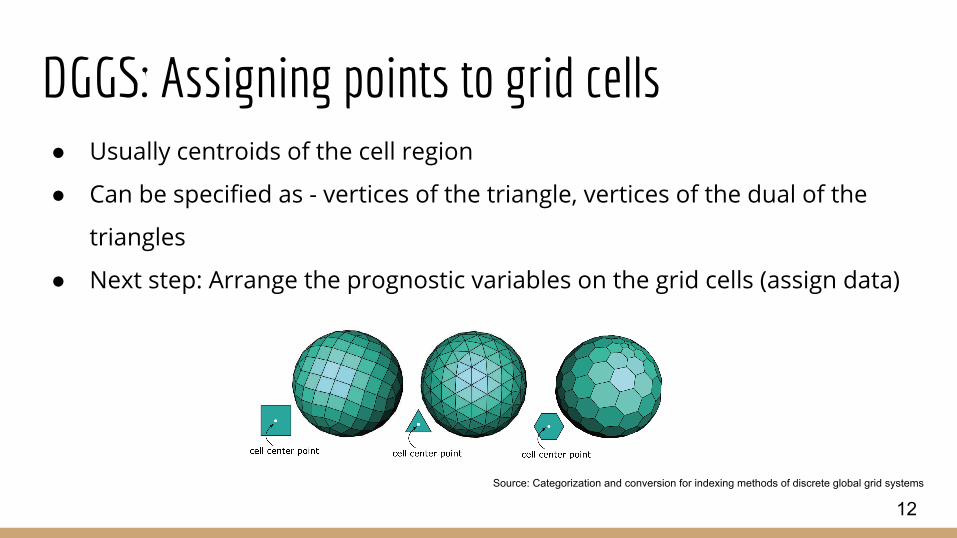
DGGS: Assigning points to grid cells ● Usually centroids of the cell region
● Can be specified as - vertices of the triangle, vertices of the dual of the
triangles
● Next step: Arrange the prognostic variables on the grid cells (assign data)
Source: Categorization and conversion for indexing methods of discrete global grid systems
12

Grid Staggering ● When all the prognostic variables are defined at the same point in a grid,
it is called an unstaggered grid (A- Grid).
● When prognostic variables are defined at more than one point in a grid, it
is called a staggered grid.○ B-Grid
○ C-Grid
○ D-Grid
○ E-Grid
Source: Grids in Numerical Weather and Climate Models
13

Grid Staggering
Source: Grids in Numerical Weather and Climate Models,Wikipedia
14

Grid Staggering
Source: Grids in Numerical Weather and Climate Models,Wikipedia
● C-Grid is popular in Weather Research and Forecasting Model
● e.g. ICON (Icosahedral non-hydrostatic)
15

ICON ● Joint project of MPI-DWD
● Used for NWP and climate research
● Icosahedral grid with C-grid staggering
Source: The Non-hydrostatic Icosahedral Atmospheric Model: description and development
16

ICON
17

ICON
18

ICON
19

ICON
20

ICON Hexagonal cells, Quadrilateral cells and Triangular cells
21

Research Goal
22

Research Goal ● Wavelets on Digital Earth data for multiresolution visualization
● Must work for all types of cellular data: Center of the hexagons, Center of
the quads and Center of the triangles.■ Need a common data structure
● Application of wavelets:■ Apply Compression
■ Observing its performance
Source: Geodesic Discrete Global Grid Systems 23

Methodology
24

Multiresolution Scheme ● Based on the work of Cohen and Schlenker
● Works for triangular grid
● Perfect reconstruction
Source: Geodesic Discrete Global Grid Systems 25

Multiresolution Scheme
26

Multiresolution Scheme
27

Conversion
28

Conversion Benefits:
● Highpass and lowpass filters remains consistent.
● Common data structure to handle neighbouring information.
● Triangles are GPU friendly (faces can be rendered using barycentric interpolation)
29

Icosahedral Map
30

Icosahedral Map ● Digital Earth grid is unstructured
● We need to store is in structured manner (inspired from ACM)
● We want to store the vertex information in 2D array (Connectivity Map)
31

Icosahedral Map ● Digital Earth grid is unstructured
● We need to store is in structured manner (inspired from ACM)
● We want to store the vertex information in 2D array (Connectivity Map)h
v
h
v
32
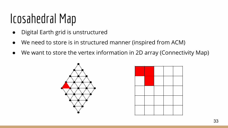
Icosahedral Map ● Digital Earth grid is unstructured
● We need to store is in structured manner (inspired from ACM)
● We want to store the vertex information in 2D array (Connectivity Map)
33

Icosahedral Map ● Digital Earth grid is unstructured
● We need to store is in structured manner (inspired from ACM)
● We want to store the vertex information in 2D array (Connectivity Map)
34

Icosahedral Map
35

Icosahedral Map
p p
p p
36

Icosahedral Map: CoH ● Center of Hexagons → Vertices of Triangles (Already!)
● Need to find connectivity information and store it in 2D array
37

Icosahedral Map: CoH
38

Icosahedral Map: CoH
39

Icosahedral Map: CoH
40

Icosahedral Map: CoH
41

Icosahedral Map
42

Icosahedral Map: CoH
43

Icosahedral Map: CoH
44

Icosahedral Map: CoQ ● Center of Quads→ Edge midpoints of Triangles
45

Icosahedral Map: CoQ
46

Icosahedral Map: CoQ
47

Icosahedral Map: CoQ
48

Icosahedral Map: CoQ
49

Icosahedral Map: CoQ
50

Icosahedral Map: CoQ
51

Icosahedral Map: CoT ● Center of Triangles→ Vertices of The voronoi cell (hexagon)
52

Icosahedral Map: CoT
53

Icosahedral Map: CoT
54

Icosahedral Map: CoT
55

Icosahedral Map: CoT
56

Icosahedral Map: CoT
57

Icosahedral Map: CoT
58

CompressionZero out magnitudes in details based on threshold
59

Compression
60

Future Work● Reduce Empty spaces in array
● Create a single array that holds the entire polyhedron net
● GPU implementation
● Bricking
61

Thanks
62