Report to Broadland District Council › download › downloads › id › ... · The Main...
45
Report to Broadland District Council by Louise Crosby MA MRTPI an Inspector appointed by the Secretary of State for Communities and Local Government Date: 1 st June 2015 PLANNING AND COMPULSORY PURCHASE ACT 2004 (AS AMENDED) SECTION 20 REPORT ON THE EXAMINATION INTO BROADLAND DEVELOPMENT MANAGEMENT DEVELOPMENT PLAN DOCUMENT Document submitted for examination on 26 September 2014 Examination hearings held on 3 and 4 February 2015 File Ref: PINS\R2610\429\1
Transcript of Report to Broadland District Council › download › downloads › id › ... · The Main...
Report to Broadland District Council
by Louise Crosby MA MRTPI an Inspector appointed by the Secretary of State for Communities and Local Government Date: 1st June 2015
PLANNING AND COMPULSORY PURCHASE ACT 2004 (AS AMENDED) SECTION 20
REPORT ON THE EXAMINATION INTO BROADLAND DEVELOPMENT
MANAGEMENT DEVELOPMENT PLAN DOCUMENT
Document submitted for examination on 26 September 2014
Examination hearings held on 3 and 4 February 2015
File Ref: PINS\R2610\429\1

-2-
Abbreviations Used in this Report AA AAP
Appropriate Assessment Broadland Growth Triangle Area Action Plan
JCS Joint Core Strategy for Broadland, Norwich and South Norfolk CDC DMP DtC GTAA
Critical Drainage Catchments Broadland Development Management Development Plan Document Duty to co-operate Gypsy and Traveller Accommodation Assessment
HRA Habitat Regulations Assessment LDS Local Development Scheme LP Local Plan MM PPTS
Main Modification Planning Policy for Traveller Sites
SA SAP
Sustainability Appraisal Broadland Site Allocations Development Plan Document
SCI Statement of Community Involvement SCS Sustainable Community Strategy

Broadland District Council Development Management Development Plan Document, Inspector’s Report June 2015
- 3 -
Non-Technical Summary This report concludes that the Broadland Development Management Development Plan Document provides an appropriate basis for the planning of the District, providing a number of modifications are made to the Plan. Broadland District Council has specifically requested me to recommend any modifications necessary to enable the plan to be adopted. All of the modifications were proposed by the Council but where necessary I have amended detailed wording and I have recommended their inclusion after considering the representations from other parties on these issues. The Main Modifications can be summarised as follows:
• Affordable housing – additional text to address the change in national planning policy
• Policy H6 (sites for Gypsies and Travellers)- introduction of additional text to explain how the Council intends to make provision for the identified needs of gypsies and travellers
• Water related matters – an additional policy (CSU5) and text to cover in greater detail the issue of surface water drainage and flooding
• Policy GC3 (Conversion of buildings outside settlement limits) – change to policy wording and associated text to ensure compliance with the National Planning Policy Framework (the Framework)
• Policy GC4 (Design) – introduction of additional text to cover green infrastructure
• Policy GC5 (Renewable Energy) – changes to the supporting text to cover the issues of biodiversity and landscape
• Policy EN1 (Biodiversity and Habitats) – additional text to ensure the policy and supporting text reflects the advice in the Framework and the findings of the Habitat Regulations Assessment (HRA)
• Policy EN2 (Landscape) – minor word change to the policy to bring it into line with the Framework
• Policy EN3 (Green Infrastructure) – changes to reflect the conclusions of the HRA and a more flexible approach to the provision of allotments
• Policy EN4 (Pollution) – amendments to reflect the advice in the Framework • Policy TS4 (Parking guidelines) – changes to the explanatory text to reflect
recent changes to national planning policy • Introduction of a glossary of terms in Appendix 1 • Monitoring framework – addition of a monitoring framework in Appendix 2

Broadland District Council Development Management Development Plan Document, Inspector’s Report June 2015
- 4 -
Introduction 1. This report contains my assessment of the Broadland Development
Management Development Plan Document in terms of Section 20(5) of the Planning & Compulsory Purchase Act 2004 (as amended). It considers first whether the Plan’s preparation has complied with the duty to co-operate, in recognition that there is no scope to remedy any failure in this regard. It then considers whether the Plan is sound and whether it is compliant with the legal requirements. The National Planning Policy Framework (paragraph 182) makes clear that to be sound, a Local Plan should be positively prepared; justified; effective and consistent with national policy.
2. The starting point for the examination is the assumption that the local authority has submitted what it considers to be a sound Plan. The submission Plan (September 2014) is not the same as the pre-submission Plan (published April 2014) as the former includes various proposed changes to address issues raised by representors at the pre-submission stage. These proposed changes were not the subject of consultation. To avoid any confusion the examination was conducted on the basis of the wording of the pre-submission Plan, having regard to the various proposed changes put forward by the Council.
3. My report deals with the Main Modifications that are needed to make the Plan sound and legally compliant and they are identified in bold in the report (MM). In accordance with section 20(7C) of the 2004 Act the Council requested that I should make any modifications needed to rectify matters that make the Plan unsound/not legally compliant and thus incapable of being adopted. These main modifications are set out in the Appendices.
4. The Main Modifications that are necessary for soundness were discussed at the Examination hearings. Following these discussions, the Council prepared a schedule of proposed Main Modifications and carried out sustainability appraisal and this schedule has been subject to public consultation for 6 weeks. I have taken account of the consultation responses on the Main Modifications in coming to my conclusions in this report and in this light I have made some amendments to the detailed wording of one of the Main Modifications (MM29) and introduced another three (MMs38, 39 & 40). These amendments do not significantly alter the content of the modifications as published for consultation or undermine the participatory processes and sustainability appraisal that has been undertaken. They simply reflect current national planning policy. I have highlighted these amendments in the report.
5. The Council has also compiled a schedule of Minor Modifications, but since they do not affect the soundness of the plan, I have not referred to them in the report. The Council may also need to make minor edits, such as re-numbering policies, and factual updates in the final adopted version of the Plan.

Broadland District Council Development Management Development Plan Document, Inspector’s Report June 2015
- 5 -
Assessment of Duty to Co-operate 6. Section s20(5)(c) of the 2004 Act requires that I consider whether the Council
complied with any duty imposed on them by section 33A of the 2004 Act in relation to the Plan’s preparation.
7. It is clear from the evidence before me, including the Duty to Co-operate document [C19], that the Council has engaged constructively with relevant bodies prescribed in s110 of the Localism Act 2011, together with other organisations, to ensure that cross boundary issues are properly coordinated and addressed.
8. There has been close collaboration between the Greater Norwich District Councils and Norfolk County Council on the Joint Core Strategy for Broadland, Norwich and South Norfolk (JCS), and its partial review, through the Greater Norwich Development Partnership Planning Sub-Group. Various joint studies dealing with cross-boundary issues in Greater Norwich have been produced. They cover matters such as housing, gypsies and travellers, employment, transport, infrastructure, habitats and the environment, historic assets and viability evidence in relation to CIL. The Greater Norwich Development Partnership has now been replaced by the Greater Norwich Growth Board and this will carry forward its work.
9. In terms of the wider area the Norfolk Strategic Planning Group, which includes representatives from the County’s planning authorities, meets on a regular basis to consider core issues. Regarding on-going compliance, a county-wide Norfolk Strategic Planning (Member) Group was set up in 2014. This comprises elected Members of all of the planning authorities in Norfolk, together with representatives of statutory bodies, such as the Environment Agency.
10. On the basis of these findings I conclude that the Duty to Co-operate has been met.
Assessment of Soundness Preamble
11. The DMP sets out local policies and criteria which will be used to inform the assessment of development proposals and to guide the Council’s decisions on planning applications in the period to 2026.
12. This Plan together with the emerging Site Allocations DPD (SAP), the emerging Growth Triangle Area Action Plan (AAP) and the already adopted JCS will replace planning policies within The Broadland District Local Plan (Replacement) (2006).
13. An Issues and Options consultation of the DMP was published in September 2011. In light of comments received the pre-submission version was published in April 2014. The DMP was submitted to the Secretary of State for Examination on 26 September 2014.
14. The Council has sought to respond in a positive manner to representations received from the public and stakeholders at all stages of the plan making

Broadland District Council Development Management Development Plan Document, Inspector’s Report June 2015
- 6 -
process. Where possible the Council has sought to resolve soundness issues by appropriate changes to policies or supporting text. This approach has continued throughout the Examination and consequently a number of representations have been satisfactorily addressed. Constructive engagement is an essential ingredient of the local plan system and the Council has entered into the spirit of this.
Main Issues
15. Taking account of all the representations, written evidence and the discussions that took place at the examination hearings I have identified a number of main issues upon which the soundness of the Plan depends. These are dealt with below. Representations on the submitted Plan have been considered insofar as they relate to soundness, but they are not reported on individually.
General matters
Does the DMP accord with the National Planning Policy Framework and does it reflect the National Planning Policy Framework’s presumption in favour of sustainable development?
16. The Framework emphasises the importance of encouraging sustainable development through enabling economic growth and promoting housing development. The DMP is in line with this approach and contains a broad range of policies that seek to adopt this approach and have sustainable development at the heart of them. As a result, the DMP sits comfortably with the general direction of the Framework. It is based on a clear strategy that aims to meet objectively assessed development and infrastructure requirements in the district.
17. I conclude, therefore, that the DMP has been positively prepared, and accords with the thrust of the Framework.
Is the DMP in general conformity with the Joint Core Strategy for Broadland, Norwich and South Norfolk?
18. Regulation 8(4) of The Town and Country Planning (Local Planning)(England) Regulations 2012 specifies that subject to paragraph (5) the policies contained in a local plan must be consistent with the adopted development plan.
19. The JCS was adopted in 2011 but was subject to legal challenge. As a consequence parts of the JCS concerning certain development proposals in the Broadland part of the Norwich Policy Area were remitted to Regulation 19 stage. Part of the JCS subsequently underwent public examination in 2013 and resultant amendments were adopted on 10 January 2014.
20. The JCS identifies Norwich as a main focus for growth in the East of England,
for new homes and jobs, leisure, cultural and educational development. It recognises though that the economic, social and cultural influence of the city extends into the neighbouring districts, including Broadland. It notes that in the rural areas, market towns continue to provide the most sustainable focus for development. The DMP, along with the emerging SAP and the emerging

Broadland District Council Development Management Development Plan Document, Inspector’s Report June 2015
- 7 -
AAP seek to deliver the growth strategy for Broadland that is set out in the JCS.
21. The DMP is in conformity with the JCS in so far as its policies are designed to
ensure that the natural environment is afforded adequate protection. The DMP adds to the strategic policies set out in the adopted JCS.
22. The DMP highlights the policy requirements of the JCS in respect of affordable housing. This seeks to ensure a proportion of affordable housing is provided on all sites for 5 or more dwellings. However, a recent Written Ministerial Statement says that contributions should not be sought from developments of 10 dwellings or less (except in specific designated areas) and that this is now national planning policy. Additional text is necessary to cover this. This is dealt with by MM29, which is necessary for soundness.
What alternatives to the policies in the Plan have been considered?
23. It is clear from the submitted DMP and the supporting evidence, that reasonably alternative policies were considered before finalising the Plan. Various rounds of consultation have taken place with the public and stakeholders. Also, the policies in this Plan as well as the alternatives that were considered have been subject to sustainability appraisal.
24. I conclude that the Council has adopted a robust and systematic approach to policy formulation and that alternative policies to those in the Plan have been given due consideration.
Should the Plan contain a monitoring framework and glossary of terms?
25. A monitoring framework is necessary to show how the implementation of policies in the Plan is progressing. Without this the Plan would not be effective and therefore unsound. Main Modification MM37 remedies this. This will form an appendix to the Plan.
26. Subject to the inclusion of MM37 the Plan is soundly based.
27. A glossary of terms to aid with the understanding of the Plan is necessary. Main Modification MM36 contains such a glossary. This will form an appendix to the Plan.
28. Subject to the inclusion of MM36 the Plan is soundly based.
Are the policies in the Plan based on a robust and up-to-date evidence base?
29. The Plan is supported by an extensive evidence base. A great deal of the evidence was originally prepared to inform the production of the JCS which commenced in 2006 and was completed in 2014. The evidence base was therefore compiled over a long period of time, with various pieces of evidence being added and updated over this period. The DMP has to be in conformity with the JCS and so this evidence base is relevant. Moreover, specific evidence has been gathered for this Plan. This includes documents such as viability assessments, sustainability appraisals and habitat regulations

Broadland District Council Development Management Development Plan Document, Inspector’s Report June 2015
- 8 -
assessments, and taken together, the evidence documents provide a sound underpinning for the Plan.
30. I conclude that the policies in the Plan are based on a robust and up-to-date evidence base.
Should the Plan contain a specific policy to deal with water related matters, including flood risk and surface water drainage?
31. The Framework at paragraph 99 advises that Local Plans should take account of climate change over the longer term, including factors such as flood risk and changes to biodiversity. It also advises on the use of green infrastructure to help manage vulnerable areas. The Local Flood Risk Management Strategy, which is at an advanced stage of production, identifies a number of places in the Norwich urban area (including some in Broadland) where the risk of flooding is highest.
32. These are defined as Critical Drainage Catchments (CDCs) and are discrete geographical areas where multiple and interlinked sources of flood risk cause flooding in one or more local flood risk zones during severe weather. As a consequence they affect people, property or local infrastructure. It is also likely that additional CDCs will be identified within Broadland as a result of either future studies or flood investigations.
33. Within such areas development needs to be tightly managed and advice on flood risk mitigation and sustainable drainage sought from developers because there are locations where an engineering solution may be impractical, unaffordable or financially unsustainable. Moreover, often the wider flood implications of development need to be considered, such as the effects downstream of increased volumes of water or flow rates.
34. Main Modification MM22 introduces an additional policy CSU5 – Surface Water Drainage. This detailed policy seeks to address the local drainage issues described above and will ensure that mitigation measures are incorporated into development to minimise the risk of flooding both on the site and elsewhere.
35. Additional text is necessary to support this policy and provide additional information, such as the location of the CDCs and this is provided by Main Modifications MMs23-28.
36. In other relevant parts of the Plan Main Modifications MMs1, 2, 14 & 15 provide guidance in relation to flooding as well as biodiversity and water quality which can also be adversely affected by flooding.
37. It is essential that all of these Main Modifications are included in the Plan to ensure that developers are aware of the sensitive flood risk and biodiversity issues in the district and design development with appropriate surface water drainage schemes.
38. In conclusion, Main Modifications MMs1, 2, 14, 15 & 22-28 are necessary for soundness.

Broadland District Council Development Management Development Plan Document, Inspector’s Report June 2015
- 9 -
Policy H6 – Sites for Gypsies and Travellers
39. JCS policy 4 says that within Broadland provision will be made for 15 gypsy and traveller sites for the period 2006 to 2011 and 20 in the period 2012 and 2026. However, these figures were based on the revoked Regional Spatial Strategy and the policy does say that when this happens new targets for the period after 2011 will be set, based on local evidence. This is the approach recommended in Planning Policy for Traveller Sites (PPTS).
40. More recent targets have been set through the Greater Norwich Gypsy and Traveller Accommodation Assessment (GTAA) 2012. This identifies a need in Broadland for 3 pitches from 2011 to 2016 which has been met through planning permissions. A further 3 pitches have been granted planning permission, thereby adding to the supply of pitches. Consequently, because of the Council’s positive approach to accommodating gypsies and travellers in the District there is currently no evidence of any unmet need for gypsy and traveller sites. Indeed the Council has granted planning permission for more sites than were identified in the most recent GTAA.
41. Paragraph 10 of PPTS advises that ‘where there is no identified need, criteria-based policies should be included to provide a basis for decisions in case applications nevertheless come forward’. Policy H6 of the Plan deals with windfall sites outside development limits.
42. The Council intends to review the GTAA in 2015/16 and the need identified
through this will inform either a review of the SAP, which is currently being examined, or a separate gypsy and traveller site allocation plan.
43. While it will be the job of the SAP review or the gypsy and traveller site allocation plan to allocate sites to meet future need, this DMP sets out the approach to dealing with this matter in explanatory text related to policy H6. In response to the concerns I raised about the lack of a commitment in this text to addressing future need, in accordance with Policy B of PPTS, the Council has proposed some Main Modifications MMs30-32 to the supplementary text associated with policy H6.
44. The Council has also updated their Local Development Scheme (LDS) to reflect this commitment. Main Modifications MMs30-32 clarify the approach that is being followed by the Council and address my original concerns. These modifications are necessary to make the Plan justified and effective.
Policy GC3 – Conversion of buildings outside settlement limits
45. Paragraph 55 of the Framework promotes sustainable rural housing. Accordingly, it advises against isolated new homes in the countryside except where there are special circumstances. One such circumstance is where the development would re-use redundant or disused buildings and lead to an enhancement to the immediate setting.
46. However, it does not say that such proposals will need to be within a set
distance of a settlement limit or that different criteria should be applied to buildings of historical or architectural merit. Nor does it suggest that local planning authorities should consider such an approach in their local plan.

Broadland District Council Development Management Development Plan Document, Inspector’s Report June 2015
- 10 -
47. Main Modifications MMs33-35 would ensure that this policy accurately reflects
the advice in the Framework. Subject to these changes policy GC3 is soundly based.
Policy GC4 - Design
48. This policy is a general design policy that reflects the thrust of chapter 7 of the Framework – ‘Requiring Good Design’. However, given the importance of Green Infrastructure in the district and the important role this will have in delivering mitigation on Natura 2000 sites, the supplementary text needs to give this important matter greater coverage in this part of the DMP and provide a reference to policy EN3 which deals with green infrastructure in greater detail. This reflects the guidance in paragraph 114 of the Framework and would be achieved through Main Modification MM3.
49. The supplementary text should make reference to Policy EN1 – ‘Biodiversity and Habitats’, in order to provide a more general overview. This is remedied through Main Modification MM16.
50. The Council are proposing a change to the wording of the supplementary text that deals with residential amenity through Main Modification MM21. Essentially the thrust of what is being said is the same, but the re-wording improves the grammar and legibility of this section of text.
51. Main Modifications MMs3, 16 & 21 are necessary for soundness.
Policy GC5 – Renewable Energy
52. The Framework at paragraph 97 promotes the use of renewable and low carbon energy, but also recognises the need for policies to have regard to adverse impacts. Biodiversity and the landscape are important issues when considering renewable energy projects and particularly so in this district and the surrounding area given the presence of European and Ramsar designated sites as well as international wildlife sites (Natura 2000 sites). This omission is resolved through Main Modification MM4 to the supporting text and is necessary for the policy to be justified and effective.
Policy EN1 – Biodiversity and Habitats
53. As set out above, this district and the surrounding area contains important national and international wildlife sites. MMs 5 & 7 are recommended in order that the supporting text to policy EN1 fully reflects the advice in the Framework in relation to the local and natural environment, best and most versatile agricultural land, and to water pollution and its potential effect on the water environment within the designated sites.
54. Reference to other important relevant legislation and the HRA that was carried out to inform this Plan and their significance is important. Likewise information about the need for evidence to show that consideration has been given to the protection and enhancement of biodiversity in designing development is necessary as well as reference to sites of special scientific interest. This is remedied through Main Modifications MMs7-11.

Broadland District Council Development Management Development Plan Document, Inspector’s Report June 2015
- 11 -
55. Main Modifications MMs5 & 7-11, are required for soundness.
Policy EN2 – Landscape
56. “Protect and enhance” are terms frequently used throughout the Framework, particularly in the context of both the natural and historic environment. Policy EN2 covers both of these subjects. Accordingly, Main Modification MM6 would bring this policy in line with the Framework and is necessary for soundness.
Policy EN3 – Green Infrastructure
57. Policy EN3 seeks to ensure that all development maximises opportunities for the creation of a well-managed network of wildlife habitats. It sets standards for informal open space and allotments for residential development. I expressed concerns about the blanket approach to allotments regardless of whether there was a demonstrable need. In order to overcome this, the Council has introduced some explanatory text through Main Modification MM19.
58. The HRA for the SAP was unable to conclude that development through the allocations would not have an adverse effect, through increased recreational pressure, on Broadland Natura 2000 sites. It identified that mitigation is required, through green infrastructure provision, to address the impacts of additional recreational pressure on these sites. The additional wording in the supplementary text to policy EN3, set out in Main Modifications MMs12, 13, 17 & 18, would achieve this.
59. Subject to Main Modifications MMs12, 13, 17, 18 & 19, this policy is soundly based.
Policy EN4 – Pollution
60. This policy seeks to ensure that any pollution risks associated with a development are identified and mitigated so that no significant adverse impact on amenity, human health or the environment occurs, in accordance with paragraph 120 of the Framework. Main Modification MM20 corrects a grammatical error which is required for the policy to be effective. As such, MM20 is necessary for soundness.
Policy TS4 – Parking guidelines
61. This policy seeks to ensure that new development has appropriate car parking and manoeuvring space provided, based on its use and location. The associated explanatory text at paragraph 8.18 sets out the relevant advice in the Framework. It also advises in the supporting text at paragraph 8.20, that adopted parking standards are set out in a Supplementary Planning Document.
62. A recent written ministerial statement, dated 25 March 2015, says that, “local planning authorities should only impose local parking standards for residential and non-residential development where there is clear and compelling justification that it is necessary to manage their local road network”. No such evidence is available. Main Modification MM38 deletes paragraph 8.20. Additions to the text in paragraphs 8.18 and 8.19, set out in Main

Broadland District Council Development Management Development Plan Document, Inspector’s Report June 2015
- 12 -
Modifications MMs39 & 40, reflect this change to national planning policy and ensure that the policy is justified and effective.
63. Main modifications MMs39 & 40 are required for soundness.

Broadland District Council Development Management Development Plan Document, Inspector’s Report June 2015
- 13 -
Assessment of Legal Compliance 64. My examination of the compliance of the Plan with the legal requirements is
summarised in the table below. I conclude that the Plan meets them all.
LEGAL REQUIREMENTS
Local Development Scheme (LDS)
The DMP is identified within the approved LDS February 2014 which sets out an expected adoption date of March 2015. The Local Plan’s content and timing are compliant with the LDS.
Statement of Community Involvement (SCI) and relevant regulations
The SCI was adopted in April 2006 and consultation has been compliant with the requirements therein, including the consultation on the post-submission proposed ‘main modification’ changes (MM)
Sustainability Appraisal (SA)
SA has been carried out and is adequate.
Appropriate Assessment (AA)
The Habitats Regulations AA Screening Report (March 2014 together with subsequent reviews) sets out why AA is not necessary.
National Policy The DMP complies with national policy except where indicated and modifications are recommended.
Sustainable Community Strategy (SCS)
Satisfactory regard has been paid to the SCS.
Public Sector Equality Duty (PSED)
The DMP complies with the Duty.
2004 Act (as amended) and 2012 Regulations.
The DMP complies with the Act and the Regulations.
Overall Conclusion and Recommendation 65. The Plan has a number of deficiencies in relation to soundness and/or
legal compliance for the reasons set out above which mean that I recommend non-adoption of it as submitted, in accordance with Section 20(7A) of the 2004 Act. These deficiencies have been explored in the main issues set out above.
66. The Council has requested that I recommend main modifications to make the Plan sound and/or legally compliant and capable of adoption. I conclude that with the recommended main modifications set out in the Appendices the Broadland Development Management Development Plan Document satisfies the requirements of Section 20(5) of the 2004 Act and meets the criteria for soundness in the National Planning Policy Framework.
Louise Crosby Inspector

Broadland District Council Development Management Development Plan Document, Inspector’s Report June 2015
- 14 -
This report is accompanied by the Appendices containing the Main Modifications. These comprise of the recommended Main Modifications, the monitoring framework and a glossary of terms.

Schedule of recommended (Main) Modifications to Development Management DPD – Proposed Submission
Following the Hearing on the Development Management DPD the following Main Modifications are proposed. Main Modifications are more substantive changes which significantly alter a policy or text (e.g. rewording policies, adding new sites or deleting existing ones). The modifications below are expressed either in the conventional form of strikethrough for deletions and underlining and bold for additions of text, explanatory notes (i.e. text that is not to be included as part of the modification) are expressed in italics. The page numbers and paragraph numbering below refer to the Proposed Submission local plan, and do not take account of the deletion or addition of text.
Ref. Page Policy / Paragraph
Main Modification
MM1 7 2.6 Water Resources and Water Quality Paragraphs 94 and 99 of the NPPF require local planning authorities to take into account water supply and demand. Paragraph 110 of the NPPF states that ‘In preparing plans to meet development needs, the aim should be to minimise pollution and other adverse effects on the local and natural environment.’ All new developments will ensure that there will be no adverse impacts on the water environment, including European and Ramsar sites and other designated sites through surface and storm water runoff, water abstraction, or sewerage discharge in accordance with the Habitat Regulations Assessment (HRA). All new development will ensure that the requirements of the Water Framework Directive (WFD) are met within the wider water environment. Policies 1 and 3 of the JCS emphasise the need for development to take into account water quality, the availability of water resources and the impact of increased abstraction.
MM2 7 2.7 Advice received from the Environment Agency and Natural England will be taken into account in the determination of development proposals. Development will not be permitted where there is significant risk to water resources or water quality.

MM3 11 2.24 Replacement of paragraph:
Adequate green space should be provided within schemes that is publicly accessible and links to surrounding areas. Appropriate infrastructure should be provided including adequate greenspace provision and other green infrastructure linking to the surrounding area, in accordance with Policy EN3 in the Environment chapter of this DPD.
MM4 12 2.29 It is important to ensure sufficient protection for the particularly distinctive and sensitive biodiversity and landscape areas. The impact of renewable energy projects upon such areas should therefore be considered carefully taking account of the Landscape Character Assessment SPD and biodiversity information.
MM5 14 EN1 Policy EN1 – Biodiversity and Habitats Development proposals will be expected to protect and enhance the biodiversity value of the district, avoid fragmentation of habitats and support the delivery of a co-ordinated green infrastructure network throughout the district. Where harmful impacts may occur, it should be adequately demonstrated that:
(i) The development cannot be located where it would cause less or no harm; and
(ii) Adequate mitigation is incorporated, including specific mitigation requirements to address impacts upon international wildlife sites (Natura 2000 sites); and
(iii) The benefits of the development clearly outweigh the impacts.
MM6 16 EN2 Policy EN2 – Landscape In order to protect the character of the area, development proposals should have regard to the Landscape Character Assessment SPD and, in particular, consider any impact upon as well as seek to protect and enhance where appropriate:
(i) Gaps between settlements; (ii) Visually sensitive skylines, hillsides and

valley sides and important views including the setting of the Broads Area;
(iii) Nocturnal character; (iv) Conservation Areas; (v) Scheduled Ancient Monuments; (vi) Historic Parks and Gardens; and (vii) Green spaces including natural and semi-
natural features as well as geological/geomorphological features which make a significant contribution towards defining the character of an area.
MM7 14 3.6 Paragraph 61 of the NPPF states that planning
policies and decisions should address the connections between people and places and the integration of new development into the natural, built and historic environment. Paragraphs 109 – 125 set out the Governments view on conserving and enhancing the natural environment. In particular, paragraph 110 of the NPPF states that ‘In preparing plans to meet development needs, the aim should be to minimise pollution and other adverse effects on the local and natural environment.’ All new developments will ensure that there will be no adverse impacts on the water environment, including European and Ramsar sites and other designated sites through surface and storm water runoff, water abstraction, or sewerage discharge in accordance with the Habitat Regulations Assessment (HRA). All new development will ensure that the requirements of the Water Framework Directive (WFD) are met within the wider water environment. Paragraph 112 states the economic and other benefits of best and most versatile agricultural land should be taken into account and that where significant development of agricultural land is necessary, local planning authorities should seek to use areas of poorer quality land in preference to that of higher quality. Paragraph 113 states that local planning authorities should set criteria based policies against which proposals for any development on or affecting protected wildlife or geodiversity sites or landscape areas will be judged. In addition, paragraph 117 states that planning policies should plan for biodiversity at a landscape-scale across local authority boundaries; identify and map components of the local ecological networks, including the hierarchy of international, national and locally designated sites of importance for biodiversity, wildlife corridors and stepping stones that
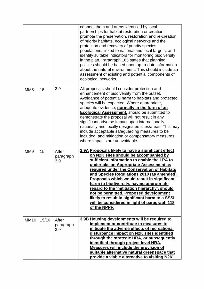
connect them and areas identified by local partnerships for habitat restoration or creation; promote the preservation, restoration and re-creation of priority habitats, ecological networks and the protection and recovery of priority species populations, linked to national and local targets, and identify suitable indicators for monitoring biodiversity in the plan. Paragraph 165 states that planning policies should be based upon up-to-date information about the natural environment. This should include an assessment of existing and potential components of ecological networks.
MM8 15 3.9 All proposals should consider protection and enhancement of biodiversity from the outset. Avoidance of potential harm to habitats and protected species will be expected. Where appropriate, adequate evidence, normally in the form of an Ecological Assessment, should be submitted to demonstrate the proposal will not result in any significant adverse impact upon internationally, nationally and locally designated sites/areas. This may include acceptable safeguarding measures to be included, and mitigation or compensatory measures where impacts are unavoidable.
MM9 15 After paragraph 3.9
3.9A Proposals likely to have a significant effect on N2K sites should be accompanied by sufficient information to enable the LPA to undertake an Appropriate Assessment as required under the Conservation of Habitats and Species Regulations 2010 (as amended). Proposals which would result in significant harm to biodiversity, having appropriate regard to the ‘mitigation hierarchy’, should not be permitted. Proposed development likely to result in significant harm to a SSSI will be considered in light of paragraph 118 of the NPPF.
MM10 15/16 After
paragraph 3.9
3.9B Housing developments will be required to implement or contribute to measures to mitigate the adverse effects of recreational disturbance impact on N2K sites identified through the strategic HRA, or subsequently identified through project level HRA. Measures will include the provision of suitable alternative natural greenspace that provide a viable alternative to visiting N2K

sites for daily recreational needs. Green Infrastructure provision will be in line with Policy EN3 Green Infrastructure requirements and have regard to green infrastructure projects identified within the Greater Norwich Infrastructure Plan or future iteration of this. Green Infrastructure provision or contribution to this will be secured through planning permissions, including S106 obligations or unilateral undertakings, or CIL.
MM11 15/16 After paragraph 3.9
3.9C All new developments will ensure that there will be no adverse impacts on the water environment, European and Ramsar sites and other designated sites in the area and beyond including by storm water runoff, water abstraction, or sewerage discharge in accordance with the Water Framework Directive (WFD). The particularly sensitive N2K sites are: The Broads SAC, The Broads RAMSAR Site, The Broadland SPA, The River Wensum SAC, Winterton-Horsey Dunes SAC, Breydon Water SPA RAMSAR, Norfolk Valley Fens SAC and Great Yarmouth North Denes; as identified in the HRA.
MM12 18 3.17 Improving the quality and accessibility of informal open space is of such importance that residential development consisting of five dwellings or more is expected to provide a contribution towards its enhancement and maintenance. The Council will seek to ensure the provision of adequate informal open space to meet the recreational needs of existing and future residents and to mitigate the potential impacts of visitor pressure upon sensitive internationally designated sites (Natura 2000 sites) as identified in the HRA and referred to in Policy EN1 of this DPD. Where appropriate on-site provision will be expected, and this will need to be adequate to provide a viable alternative to visiting Natura 2000 sites or contribute to the provision of a viable alternative as part of a wider green Infrastructure network. On sites where adequate provision cannot be achieved, off-site provision is necessary. The requirement for informal open space set out within this policy is in addition to the formal recreational provision requirement set out in Policy RL1 of this DPD. However, in general new areas of open space created should be multi-functional serving

a variety of purposes e.g. where appropriate they could incorporate formal and informal recreational provision as well as sustainable drainage areas where appropriate (in accordance with paragraph 99 of the NPPF).
MM13 19 3.20 As part of the background work underpinning the JCS, a Green Infrastructure Study and Green Infrastructure Delivery Plan were produced which development proposals should have regard to. In addition to necessary green infrastructure being provided related to the development, other strategic elements of green infrastructure will be sought. This may include some of the priorities identified in the Greater Norwich Green Infrastructure Study, the Greater Norwich Green Infrastructure Delivery Plan, the Green Infrastructure Topic Paper and the Local Infrastructure Plan and Programme (LIPP) and the projects formalised within the GNIP, or future iterations of these. Strategic green infrastructure provision will be funded through the Community Infrastructure Levy (CIL) or other funding sources. Delivery of the informal recreational provision to provide mitigation that has been identified as being necessary will be secured through s106 obligations or other legal agreement or appropriate mechanism.
MM14 47 9.3 The policies contained within this document do not repeat those set out within the NPPF and JCS. Therefore, in addition to the policies contained within this chapter, development proposals should also pay adequate regard to the guiding principles contained within those higher level documents. Of particular relevance in respect of this chapter are the references to telecommunications, climate change, flooding and coastal change as well as the integrity of tidal or fluvial flood defences and infrastructure.
MM15 47 9.4 Replacement title: Climate change, flooding and coastal change Integrity of tidal or fluvial flood defences Paragraphs 93-108 of the NPPF provide extensive guidance for local planning authorities on climate change, flooding and coastal change. Paragraph 99 states that ‘Local Plans should take account of climate change over the longer term, including

factors such as flood risk, coastal change, water supply and changes to biodiversity and landscape. New development should be planned to avoid increased vulnerability to the range of impacts arising from climate change. New development should incorporate suitable adaptation measures, including through the planning of green infrastructure.’ Paragraph 103 states that flood risk should not be increased elsewhere as a result of development and gives high priority to the use of SUDS. Policy 1 of the JCS states that to address climate change and promote sustainability, All development will be located and designed to be adapted to a changing climate and more extreme weather; and be sequentially located to minimise flood risk from all sources of flooding in accordance with policy 1 of the JCS. In accordance with paragraphs 93-108 of the NPPF and Policy 1 of the JCS, planning permission will not be granted for development that adversely significantly affects the integrity of tidal or fluvial defences. Where planning permission is given, the developer must ensure that the stability and continuity of the defences is maintained. The Environment Agency will be consulted on applications within 20 metres of a defence and any development within 9 metres of a flood defence requires Flood Defence Consent from them. Additionally in considering flood risk issues, regard will be had to the Norwich Surface Water Management Plan. Other relevant surface water management plans/guidance produced by the County Council as lead Local Flood Authority, including the emerging Local Floodrisk Management Strategy, will also be taken into account. The overall aim is to reduce the risks of flooding across the catchments. Advice received from the Environment Agency and the Lead Local Flood Authority will be taken into account in the determination of planning applications.
MM16 11 2.22 Paragraphs 109-125 of the NPPF set out the Government’s view on conserving and enhancing the natural environment and the considerations that apply when assessing the potential impacts of pollution. Development will therefore not be permitted which would result in any significant unacceptable impact upon the environment, health, or amenity. In particular, the degree of overlooking, over shadowing and over massing should be taken into account in considering the impact of new development upon

neighbouring properties. Also the potential impact associated with light, noise, odour, dust and other atmospheric pollutants arising from any new development should be considered. Regard should also be had to Policies EN1 and EN4 in the Environment chapter of this DPD.
MM17 19 After paragraph 3.19
3.20A The Council will ensure the provision of adequate informal open space to meet the recreational needs of future residents and to mitigate the potential impacts of visitor pressure upon sensitive internationally designated sites (Natura 2000 sites) as identified in the HRA and referred to in Policy EN1 of this DPD. Where appropriate, on-site provision will be expected and this will need to be adequate to provide a viable alternative to visiting Natura 2000 sites or contribute to the provision of a viable alternative as part of a wider green Infrastructure network. On sites where adequate provision cannot be achieved, off-site provision is necessary.
MM18 19 After
paragraph 3.19
3.20B The provision of green infrastructure is of particular importance to address the potential impacts of increased visitor pressure on Natura 2000 sites, as identified in the HRA. Therefore, it will need to be ensured that the type of green infrastructure provided includes attractive, accessible greenspace that gives a credible alternative to visiting those sites. This may include some of the priorities identified in the Greater Norwich Green Infrastructure Study, the Greater Norwich Green Infrastructure Delivery Plan, and the projects formalised within the GNIP, or future iterations of these.
MM19 18 3.18 The Council recognises that there may be some
circumstances where it is not appropriate to meet the green infrastructure requirement on-site. In addition, it may not always be necessary to provide allotments for example, where there is a surplus in an area. Consequently, it is acknowledged that a flexible approach will need to be adopted in applying

the policy. Therefore in seeking to apply this policy the Council will negotiate the provision on individual proposals taking into account matters such as the scale of the development proposed, characteristics and location of the site and the standard of existing provision within the area. Where there is an identified deficit the Council will seek to address this if possible. On larger sites meaningful on-site provision is more likely to be achievable. However, it is more likely that the requirement will need to be commuted for smaller developments.
MM20 19 EN4 Policy EN4 – Pollution Development proposals will be expected to undertake include an assessment of the extent of potential pollution. Where pollution may be an issue, adequate mitigation measures will be required. Development will only be permitted where there will be no significant adverse impact upon amenity, human health or the natural environment.
MM21 10/11 2.20 Paragraph 50 of the NPPF states that local planning authorities should seek to create sustainable, inclusive and mixed communities. Policy 7 of the JCS also states that integration and cohesion within and between new and existing communities will be promoted. Development proposals should therefore create sustainable, inclusive and mixed communities by, for example, seeking to ensure that affordable housing is well integrated with market housing and creating opportunities for people to meet formally and informally. New living accommodation should be designed to meet the reasonable amenity needs of allow potential future occupiers. to live comfortably and conveniently with sSufficient internal and external living space should be provided that is should meet the reasonable needs of occupiers i.e. not excessively over looked, over shadowed or adversely affected by noise etc. and therefore allows occupants to live comfortably and conveniently.
MM22 52 New CSU5 Insert new policy: Policy CSU5 – Surface water drainage
Mitigation measures to deal with surface water arising from development proposals should be incorporated to minimise the risk of flooding on

the development site without increasing flood risk elsewhere.
In particular, within the Critical Drainage Catchments and other areas at significant risk of flooding as identified by the Lead Local Flood Authority, all development proposals involving new buildings, extensions and additional areas of hard surfacing should ensure that adequate and appropriate consideration has been given to mitigating surface water flood risk.
Developers will be required to show that the proposed development would:
i) not increase the vulnerability of the site, or the wider catchment, to flooding from surface water run-off from existing or predicted water flows; and
ii) wherever practicable, have a positive impact on the risk of surface water flooding in the wider area.
Development must, as appropriate, incorporate mitigation measures to reduce surface water runoff, manage surface water flood risk to the development itself and to others, maximise the use of permeable materials to increase infiltration capacity, incorporate on site water storage and make use of green roofs and walls wherever reasonably practicable.
MM23 52 After paragraph 9.19
9.19A The use of permeable materials, on-site rainwater storage, green roofs and walls will be required unless the developer can provide justification to demonstrate that this would not be practicable or feasible within the constraints or configuration of the site, or would compromise wider regeneration objectives.
MM24 52 After paragraph 9.19
9.19B Development proposals will be required to maximise the use of soft landscaping and permeable surfacing materials unless the developer can provide justification to demonstrate that this is

not feasible.
MM25 52 After paragraph 9.19
9.19C This policy requires surface water drainage issues to be addressed in planning applications, both to ensure that surface water drainage issues and associated flood risk are considered and to ensure that the impact of drainage measures on the form and visual appearance of developments is properly taken into account in the assessment of new development.
MM26 52 After paragraph 9.19
9.19D The Norwich Surface Water Management Plan investigated flood risk surface water sources in the urban area of Norwich (which includes parts of Broadland District) the investigation highlighted three particular catchments, which are especially prone to surface water flooding (and which will flood in extreme rainfall events). One of these three catchments lies entirely within Broadland and another one extends, in part, into Broadland district. The ‘Drayton Critical Drainage Catchment’ extends from a high point along Beech Road Taverham (in the west) to a high point on Reepham Road, near Westwood Drive, Hellesdon (in the east), with a low point south of St Margaret’s Church in Drayton. The ‘Catton Grove and Sewell Critical Drainage Catchment’ extends from a northern extremity near Beeston Lane, in Broadland District, down through Old Catton to a low point within the centre of Norwich City. Critical drainage catchments will be identified in the Local Flood Risk Management Strategy. Those parts of the District falling within the Critical Drainage Catchments will not necessarily flood in extreme rainfall events, but any development within them has the potential to increase the risk of

flooding in the most flood vulnerable areas, unless appropriate mitigation measures are implemented.
MM27 52 After paragraph 9.19
9.19E The modelling evidence supporting the SWMP provides justification for requiring new development in these areas to incorporate higher standards of flood resilience than are necessary elsewhere.
MM28 52 After paragraph 9.19
9.20F The policy also allows for the emergence of more extensive technical evidence on surface water flood risk to be taken into account over the plan period, so that in areas or sites outside of the Critical Drainage Catchments where available evidence indicates that there is likely to be elevated risk of surface water flooding (e.g. as a result of specific topography) the same policy requirements would apply.
MM29 21 4.10 Policy 4 of the JCS requires a proportion of affordable housing, including an appropriate tenure mix, on all sites for 5 or more dwellings (or 0.2 hectares or more). However, following a change to national planning policy in March 2015, contributions cannot be sought from developments of 10-units or less, and which have a maximum combined gross floorspace of no more than 1000sqm (gross internal area), (except in specific designated rural areas of which there are currently none in Broadland District). The proportion of affordable housing, and mix of tenure sought will be based on an up to date needs assessment for the plan area. Finally, at appropriate settlements, sites that would not normally be released for housing will be considered for schemes that specifically meet an identified local need for affordable homes. Such schemes must ensure that the properties are made available in perpetuity for this purpose. Policy 17 also makes provision for exception sites.
MM30 27 After paragraph 4.40
4.40A The District Council will be undertaking a review of gypsy and traveller accommodation needs in 2015/16, updating the Gypsies and Travellers

Accommodation Assessment (GTAA) published in 2012. This will be undertaken individually or jointly with other authorities, and in accordance with the Duty to Co-operate.
MM31 27 After paragraph 4.40
4.40B Any future needs for gypsy and traveller accommodation that are identified through the work will be addressed, in planning terms, through the review of the Broadland Site Allocations Plan or a focussed Local Plan dealing specifically with this matter.
MM32 27 After
paragraph 4.40
4.40C The current need for gypsy and traveller accommodation, identified through the Gypsy and Traveller Accommodation Assessment (GTAA) 2012, have been addressed through a number of planning permissions given in recent years and this approach will continue if further demonstrable needs arise in the meantime.
MM33 9 Policy GC3 Policy GC3
Outside settlement limits proposals for the conversion of buildings for employment uses and tourist accommodation will be permitted where: (i) The building is capable of conversion without
substantial alteration. Proposals for residential use will be permitted where criteria (i) above is satisfied in addition to the following:
The building is within 1km of a settlement limit and the conversion will lead to an enhancement of the immediate setting.; or
(ii) The conversion will maintain or enhance the
clear architectural or historic merit of a building which is more than 1km from a settlement limit.
MM34 9 2.15 The adaptation to new uses of buildings in the
countryside can be undertaken to bring them back into productive use and so be of value in

diversifying the rural economy. In determining proposals for the re-use of redundant or disused buildings for residential purposes the Council will have regard to paragraph 55 of the NPPF as well as the requirements set out in this policy. However, tThe building must be suitable for conversion i.e. without major rebuilding and/or extensions. In addition, Tthe conversion should not be detrimental to the character of the building or the surrounding area for example through the introduction of ancillary structures or means of enclosure associated with the use into the countryside. Where conversion is allowed, a condition restricting permitted development rights may be imposed.
MM35 9 2.17 Delete paragraph 2.17:
Residential use will be considered in the case of buildings of particular significance which are within reasonable walking distance of a nearby settlement, provided that the conversion will result in a positive impact upon the character of the area.
MM36 52 After
paragraph 9.19
Insert Glossary – see Appendix 1 attached
MM37 52 After paragraph 9.19
Insert Monitoring Framework – see Appendix 2 attached
MM38 43 8.20 Delete paragraph 8.20
The Council has adopted Parking Standards which are set out in a Supplementary Planning Document. This also provides guidance on design, location servicing and drainage (amongst others) that should be adhered to.
MM39 43 8.18 Paragraph 39 of the NPPF states that if setting local parking standards, local planning authorities should consider the accessibility of the development; the type, mix and use of development; the availability of and opportunities for public transport; local car ownership levels; and an overall need to reduce the use of high-emission vehicles. A Written Ministerial Statement in March 2015 stated that the following text must be read alongside paragraph 39, “Local Planning authorities should only impose local

parking standards for residential and non-residential development where there is clear and compelling justification that it is necessary to manage their local road network”. Consequently, the acceptability of the parking provision within developments will be considered as part of the overall assessment of the development proposal and the impacts that may arise from it.
MM40 43 8.19 Policy 9 of the JCS seeks to restrain parking in areas
with good standards of public transport accessibility, especially in and around the city centre. This will be applied to accord with current national planning policy.
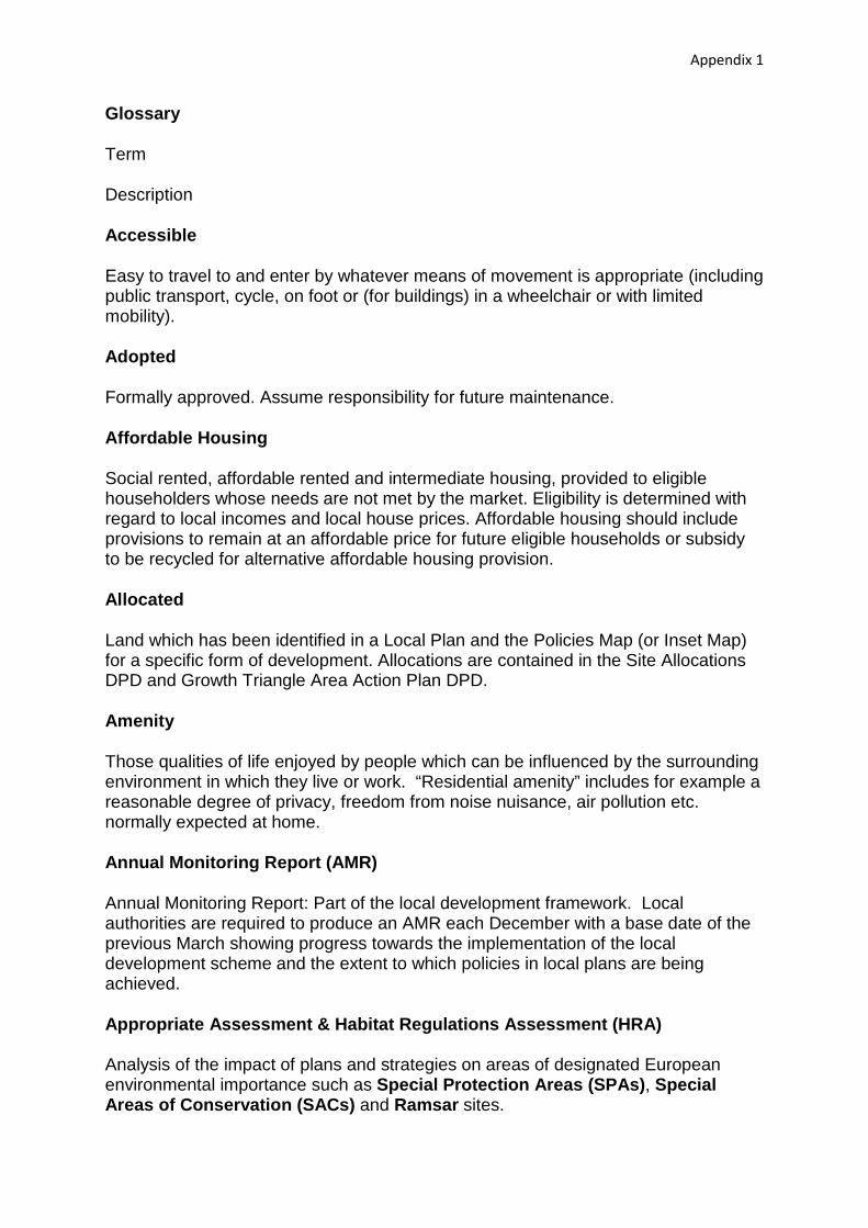
Appendix 1
Glossary
Term
Description
Accessible
Easy to travel to and enter by whatever means of movement is appropriate (including public transport, cycle, on foot or (for buildings) in a wheelchair or with limited mobility).
Adopted
Formally approved. Assume responsibility for future maintenance.
Affordable Housing
Social rented, affordable rented and intermediate housing, provided to eligible householders whose needs are not met by the market. Eligibility is determined with regard to local incomes and local house prices. Affordable housing should include provisions to remain at an affordable price for future eligible households or subsidy to be recycled for alternative affordable housing provision.
Allocated
Land which has been identified in a Local Plan and the Policies Map (or Inset Map) for a specific form of development. Allocations are contained in the Site Allocations DPD and Growth Triangle Area Action Plan DPD.
Amenity
Those qualities of life enjoyed by people which can be influenced by the surrounding environment in which they live or work. “Residential amenity” includes for example a reasonable degree of privacy, freedom from noise nuisance, air pollution etc. normally expected at home.
Annual Monitoring Report (AMR)
Annual Monitoring Report: Part of the local development framework. Local authorities are required to produce an AMR each December with a base date of the previous March showing progress towards the implementation of the local development scheme and the extent to which policies in local plans are being achieved.
Appropriate Assessment & Habitat Regulations Assessment (HRA) Analysis of the impact of plans and strategies on areas of designated European environmental importance such as Special Protection Areas (SPAs), Special Areas of Conservation (SACs) and Ramsar sites.

Appendix 1
Area Action Plan Should be used to provide the planning framework for areas where significant change or conservation is needed. A key feature of AAP’s will be the focus on implementation.
Biodiversity
The variety of life on earth or any given part of it.
Brownfield land, Brownfield Site
See Previously Developed Land
Built Environment
Surroundings which are generally built up in character. The collection of buildings, spaces and links between them which form such an area.
Business (B1) Use
Use for light industry, offices (where the office does not provide a service directly to the visiting public) and research and development (as defined in the Use Classes Order). Light industry is industry which is capable of being carried out in a residential area without causing nuisance, including as a result of traffic movement.
Commercial Centre
The centre of larger market towns and villages where there is a concentration of shops and other services which cater for customers for a group of nearby settlements.
Community
(As used in this context) All of those living and working in Broadland. This includes the general public, parish and town councils, businesses, community groups, voluntary organisations, developers, statutory agencies etc.
Community Facilities
Services available to residents in the immediate area to provide for health and wellbeing, social, educational, spiritual, recreational, leisure and cultural needs of the community. This includes village halls, post offices, doctors and dentists’ surgeries, recycling facilities, libraries and places of worship.
Community Infrastructure Levy (CIL)
Community Infrastructure Levy (CIL) is a planning charge, introduced by the Planning Act 2008 as a tool for local authorities in England and Wales to help deliver

Appendix 1
infrastructure to support the development of their area. Broadland District Council in combination with Norwich City Council and South Norfolk Council has implemented a CIL charging schedule with a list (known as the 123 List) of infrastructure projects on which the funds will be spent.
Conservation Area
Area of special historic and/or architectural interest which is designated by the Local Planning Authority as being important to conserve and enhance. Special planning controls apply within these areas.
County Wildlife Site
Wildlife habitat identified and designated as being of particular local interest of importance by Norfolk County Council and the Norfolk Wildlife Trust but which is not of sufficient national merit to be declared as a Site of Special Scientific Interest (SSSI).
Development
Defined in planning law as “the carrying out of building, engineering, mining or other operations in, on, over, or under land, or the making of a material change of use of any building or land” (see also Permitted Development).
Development Brief
See Supplementary Planning Guidance
Development Plan
The primary consideration for the Council in determining planning applications. Comprises of the Joint Core Strategy and other Development Plan Documents (including Minerals and Waste DPD’s produced by Norfolk County Council).
Development Plan Document (DPD)
Development Plan Documents: These are planning documents forming part of the local development framework and which have the status of being part of the development plan. In order to acquire this status they will be subject to independent scrutiny through a public examination. Certain documents within the local development framework must be DPDs, for example the Core Strategy, Development Management Plan, Site Specific Allocations of land and Area Action Plans where produced. There must also be an adopted Policies Map which will be amended as successive DPDs are adopted.
District Centre / District Shopping Centre
A group of shops, containing at least one supermarket or superstore and other services, providing for a catchment extending beyond the immediate locality.

Appendix 1
Employment Area
Industrial estate or other area which is used primarily for industrial, warehousing, office or other business uses falling within Classes B1, B2 and B8 of the Use Classes Order, and/or where such development is proposed.
Employment Use
Use primarily for industrial, warehousing, office or other business uses falling within Classes B1, B2 and B8 of the Use Classes Order. In the context of the local plan employment use specifically excludes retail, financial or professional services, food and drink, waste disposal or mineral extraction.
Rural Exception Site
A small site to be used specifically for affordable housing that would normally be used for housing, because they are subject to policies of restraint. Exception sites should only be used for affordable housing in perpetuity.
Geodiversity
The variety of different types of geology, landforms, soils and physical processes in a particular region.
Green Infrastructure
Green spaces and interconnecting green corridors in urban areas, the countryside in and around towns and rural settlements, and in the wider countryside. It includes natural green spaces colonised by plants and animals and dominated by natural processes and man-made managed green spaces such as areas used for outdoor sport and recreation including public and private open space, allotments, urban parks and designed historic landscapes as well as their many interconnections like footpaths, cycleways, green corridors and waterways.
Greenfield Land
Land which has not previously been built on, including land in use for agriculture or forestry and land in built up areas used for outdoor sport and recreation (including public and private open space and allotments). Does not include residential garden land.
Infrastructure
The network of services to which it is usual for most buildings or activities to be connected. It includes physical services serving the particular development (e.g. gas, electricity and water supply; telephones, sewerage) and also includes networks of roads, public transport routes, footpaths etc.
Institution

Appendix 1
Premises (not including residential) used for health care, crèche, day nursery or day centre, galleries, libraries, museum, exhibitions or worship. See also Residential Institution.
Joint Core Strategy (JCS)
The Joint Core Strategy (JCS) is a strategic local plan document produced between Broadland District Council, Norwich City Council and South Norfolk Council. This strategy sets out the key elements of the planning framework for the area. It comprises a spatial vision & strategic objectives for the area, a spatial strategy, core policies and a monitoring and implementation framework. It sets out the long term spatial vision for the area. It is a development plan document, with which all other development plans documents must conform.
Listed Building
A building of special historical and/or architectural interest considered worthy of special protection and included and described in the statutory list of such buildings published by the Secretary of State (for Culture, Media and Sport). Alteration, demolition or extension of such a Listed Building requires special consent.
Listed Building Consent (LBC)
Listed Building Consent is required from Local Planning Authorities where development involves the demolition of a listed building or a listed building is altered or extended in a manner which would affect its character as a building of special architectural or historic interest.
Local Development Order (LDO)
An Order made by a local planning authority (under the Town and Country Planning Act 1990) that grants planning permission for a specific development proposal or classes of development.
Local Development Scheme (LDS)
Local Development Scheme: Sets out the programme for preparing LDDs. This document is available to view on the Council’s website (www.broadland.gov.uk).
Local Nature Reserve (LNR)
Local Nature Reserve: Area of botanical or wildlife interest where access and use by local people is encouraged through designation by the local authority.
Local Plan
The plan for the future development of the local area, drawn up by the local planning authority in consultation with the community. In law this is described as the development plan documents adopted under the Planning and Compulsory Purchase Act 2004. Current core strategies or other planning policies, which under

Appendix 1
the regulations would be considered to be development plan documents, form part of the Local Plan. The term includes old policies which have been saved under the 2004 Act.
Local Planning Authority (LPA)
The public authority whose duty is to carry out specific planning functions for a particular area.
Local Shopping Centre
A group of shops or services forming a centre of purely local significance. See also District Shopping Centre and Commercial Centre.
Monitoring
Regular collection and analysis of relevant information in order to assess the outcome and effectiveness of Local Plan policies and proposals and to identify whether they need to be reviewed or altered.
National Planning Policy Framework (NPPF)
The National Planning Policy Framework is the Government’s national planning policy document setting out the key principles for sustainable development.
National Planning Practice Guidance (NPPG)
National Planning Practice Guidance is provided by the Government issuing guidance on the practical implementation of planning practices.
Natura 2000 Sites
Natura 2000 (N2K) sites network is an EU-wide network of nature protection areas established under the 1992 Habitats Directive. The aim of the network is to assure the long-term survival of Europe's most valuable and threatened species and habitats. It is comprised of Special Areas of Conservation (SAC) designated by Member States under the Habitats Directive, and also incorporates Special Protection Areas (SPAs) which they designate under the 1979 Birds Directive.
Northern Distributor Road (NDR)
A dual-carriageway road proposed to the north of Norwich, linking the A47 to the south-east of the city with the A1067 in the north-west.
Norwich Area Transport Strategy (NATS)
Norwich Area Transportation Strategy: Statement of strategic transportation policy for Norwich and surrounding area, most recently adopted in 2004, which was prepared jointly by Norwich City and Norfolk County Councils in discussion with Broadland and South Norfolk Councils.

Appendix 1
Norwich Fringe
Area next to the city of Norwich comprising parts of Broadland and South Norfolk which are predominantly developed, including open spaces encompassed within the developed area. For Broadland this includes the continuously built up parts of Hellesdon, Drayton, Taverham, Old Catton, Sprowston and Thorpe St Andrew.
Norwich Policy Area (NPA)
Part of the County which is centred on and strongly influenced by the presence of Norwich as a centre for employment, shopping and entertainment. In Broadland this includes 17 parishes, compromising the fringe and first ring of villages around the city of Norwich.
Outline Planning Permission (OPP)
Outline Planning Permission: This gives an outline of the proposed development, such as the Permission size and height of a building, for example. Full details of the building must be provided and approved before building work can start. Detailed planning permission must be applied for within three years.
Permitted Development
Certain categories of minor development as specified in the General Permitted Development Order, which can be carried out without having to first obtain specific planning permission. This may include specified building guidelines or change of use.
Planning Obligations
Legal agreements between a planning authority and a developer, or undertakings offered unilaterally by a developer to ensure that specific works are carried out, payments made or other actions undertaken to mitigate the impacts of development proposals. Often called Section 106 obligations. The term legal agreements may embrace S106. Planning obligations are also collected through Community Infrastructure Levy (CIL).
Policies Map
The adopted policies map illustrates all the proposals contained in development plan documents and any saved policies. It will need to be revised as each new development plan document, which has a spatial content, is adopted. As development plan documents are submitted, they will include within them a submissions policies map showing the changes which would be required upon adoption of the document.
Preferred Options

Appendix 1
Produced as part of the preparation of Development Plan Documents. It sets out the Council’s preferred options relating to the DPD and is made available to the public in order that representations can be made.
Previously Developed Land
Any land which is or was occupied by a permanent structure (excluding agricultural and forestry buildings) and associated fixed surface infrastructure, including the curtilage of (land attached to) buildings. Includes defence buildings and land used for mineral extraction or waste disposal when there is no requirement for subsequent restoration. Often called Brownfield land.
Protected Species
Any species which, because of its rarity or threatened status is protected by statutory legislation (The Wildlife and Countryside Act 1981 (as amended) and the Conservation (Natural Habitats etc.) Regulations 1994).
Public Rights of way
Public footpaths and bridleways as defined in the Countryside Rights of Way Act 2000 and permissive routes where there is no legal right of way but access is permitted by the landowner.
Ramsar Site
A European designation that protects areas of wetland.
Renewable Energy
In its widest definition, energy generated from sources which are non-finite or can be replenished. Includes solar power, wind energy, power generated from waste, biomass etc.
Reserved Matters
These relate to design, external appearance, siting, means of access and landscaping where outline planning permission has already been granted. Conditions attached to the permission may require other details to be approved (e.g. materials).
Residential Institution
Residential establishment, (which may also provide medical care or other support) in which residents live communally with catering and housekeeping services provided centrally. Includes nursing homes, residential homes and also includes hostels where a significant element of care is involved but excludes sheltered and supported housing schemes where the dwelling units are self-contained. Also excludes hotels. See also Institution.

Appendix 1
Route Hierarchy
The County Council has categorised the roads in Norfolk according to their purpose and suitability for their purpose and has defined a network serving small parts of Norfolk (cells). The following categories are included in the plan: principal routes (routes of national importance) and main distributor routes (which provide essential cross county links).
Saved Plans
Under transitional arrangements as the new style planning system is introduced, the current adopted local plan is automatically saved and retains development plan status for a period of 3 years or until superseded by development plan documents.
Scheduled Ancient Monument
Ancient structure, usually unoccupied, above or below the ground, which is preserved by order of the Secretary of State. Works affecting an ancient monument must be approved by the Secretary of State.
Section 106 Obligation (S106)
Section 106 Obligation. See Planning Obligations.
Settlement Hierarchy
A way of arranging settlements into a hierarchy based upon a number of criteria, such as population and services offered.
Settlement Limit
Settlement limits are identified on the Policies Map. These are areas where development appropriate to the settlement in question will usually be permitted subject to consideration of the policies of the NPPF, JCS and Development Management DPD.
Site of Special Scientific Interest (SSSI)
Site of Special Scientific Interest: Site or area designated as being of national importance because of its wildlife plants or flower species and/or unusual or typical geological features. SSSIs are identified by English Nature and have protected status under the Wildlife and Countryside Act 1981.
Site Specific Allocations
Allocations of sites for specific or mixed uses or development. Policies in the Site Allocations DPD will identify any specific requirements for individual sites.
Site Specific Policies

Appendix 1
Where land is allocated for specific uses (including mixed uses), this should be highlighted in one or more DPDs. The identification of sites should be founded on a robust and credible assessment of the suitability, availability and accessibility of land for particular uses or mix of uses.
Special Area of Conservation (SAC)
Special Areas of Conservation are defined in the European Union’s Habitats Directive (92/43/EEC), also known as the Directive on the Conservation of Natural Habitats and Wild Fauna and Flora. They are defined to protect the 220 habitats and approximately 1,000 species listed in Annex I and II of the Directive which are considered to be of European interest following criteria given in the Directive.
Special Protection Area (SPA)
Special Protection Areas are strictly protected sites in accordance with Article 4 of the EC Birds Directive, which came into force in April 1979. They are classified for rare and vulnerable birds (listed on Appendix I of the Directive), and for regularly occurring migratory species.
Stakeholder
(As used in this context) Any individual or organisation that has an interest in development matters relating to part or all of Broadland District.
Statement of Community Involvement (SCI)
Statement of Community Involvement: Sets out the standards which authorities will achieve with regard to involving local communities in the preparation of local development documents and development control decisions.
Strategic Environment Assessment (SEA)
Strategic Environmental Assessment: The term used to describe environmental assessment applied to policies, plans and programmes. In compliance with European SEA directive, a formal environmental assessment of land use planning proposals and plans is required. In practice SA and SEA are often combined.
Strategic Housing Land Availability Assessment (SHLAA)
A Strategic Housing Land Availability Assessment is a key component of the evidence base to support the delivery of sufficient land for housing to meet a community’s need for more homes. The assessment should be realistic in identifying land for housing that is both deliverable and developable.
Strategic Housing Market Assessment (SHMA)
A Strategic Housing Market Assessment is an assessment to establish the housing need through a comprehensive understanding of what is required to address demographic change, taking into account an area’s achievable economic potential.

Appendix 1
When a local planning authority undertakes this exercise, it should work with neighbouring authorities where housing market areas cross administrative boundaries. Supplementary Planning Document (SPD)
A Document which expands on policies set out in a DPD or provides additional detail. For example: Parking Standards, Affordable Housing, Design Guides, Area development brief etc. SPDs are not statutory requirements and do not form part of the Development Plan.
Sustainability Appraisal (SA)
Appraises policies to ensure they reflect sustainable development objectives (social, environmental and economic factors). Required by the Act to be undertaken for all local development documents. They ensure compliance with EU and UK legislation requiring Strategic Environmental Assessment.
Sustainable (Urban) Drainage System (SUDS)
Efficient drainage system which seeks to minimise wastage of water, including the use of appropriate groundcover to enable maximum penetration of clean water run-off into the ground and, where appropriate, recycling grey water within the development. Designed to minimise the impact of development on the natural water environment.
Travel Assessment
An assessment which may be required in connection with major development proposals which looks at how people are likely to access the development and its effects on travel patterns. It will also look at how any undesirable consequences can be mitigated. It should consider how access on foot, by cycle or public transport can be promoted and how the demand for car parking can be minimised.
Use Class Order (UCO)
Use Classes Order: The Town and Country Planning (Use Classes) Order, 1987, a statutory order made under planning legislation, which groups land uses into different categories (called Use Classes). Changes of use within a use class and some changes between classes do not require planning permission. Some uses (known as sui generis) do not fall within any use class.
Water Framework Directive (WFD)
The Water Framework Directive set through European legislation, requires member states (including the United Kingdom) to meet certain objectives including the improvement and the protection of the water environment. The water environment includes all rivers, canals, lakes, estuaries, wetlands and coastal waters as well as water under the ground.

Appendix 1
Windfall Site
Sites which have not been specifically identified as available in the Local Plan process. They normally comprise previously-developed sites that have unexpectedly become available.

Appendix 2
DM POLICIES MONITORING FRAMEWORK Policies JCS
Objectives SA Objectives
Indicator Target Comments
GC1 - Presumption in favour of sustainable development
1,2,3,4,5,6, 7,8,9,10,11, 12
ENV1, ENV2, ENV3, ENV4, ENV5, ENV6, ENV7, ENV8, ENV9, SOC1, SOC2, SOC3, SOC4, SOC5, SOC6, SOC7, SOC8, EC1, EC2, EC3, EC4
No specific indicator N/A See indicators for JCS objectives.
GC2 – Location of new development
1,2,3 ENV1, ENV9, SOC4, SOC7
Number of permissions granted contrary to GC2
None
GC3 – Conversion of buildings outside settlement limits
2,3,4 ENV5, ENV9, SOC 7, EC1, EC2, EC4
No specific indicator N/A See indicators for JCS objectives.
GC4 – Design 1,7,8,9,10, 11
ENV1, ENV5, ENV6, ENV9, SOC5
No specific indicator N/A See indicators for JCS objectives.
GC5 –Renewable energy
1 ENV6 Renewable energy capacity installed by type per annum
Year on year increase
This indicator is monitored as part of the JCS objectives.
EN1 - Biodiversity and Habitats
9 ENV2, ENV4, ENV5
Number of planning applications granted contrary to the advice of Natural England on the grounds of recreational impact on N2K sites
None
EN2 – Landscape
8,9 ENV2, ENV4, ENV5, ENV9
No specific indicator N/A See indicators for JCS objectives.
EN3 – Green 8,9 ENV2, ENV4, No specific indicator N/A See indicators for JCS

Appendix 2 infrastructure ENV5, ENV9 objectives – see also
indicator for recreational open space (RL1).
EN4 – Pollution 1,7,9 ENV1, ENV2, ENV3, ENV4, ENV5, ENV6, ENV7, ENV9
Number of permissions granted contrary to the advice of the Environment Agency (on pollution grounds)
None
H1 – Dwellings connected with rural enterprises
2,3 ENV1, SOC6, SOC8, EC1, EC2, EC3, EC4
No specific indicator N/A See indicators for JCS objectives.
H2 – Removal of occupancy conditions
2 ENV9, SOC4, SOC7
No specific indicator N/A See indicators for JCS objectives.
H3 – Replacement dwellings outside settlement limits
2,9 ENV9, SOC4, SOC7
Number of units granted planning permission for replacement dwellings outside of settlement limits
No target Monitoring to include a commentary on confidence with the policy.
H4 – Change of use of a dwelling
2 ENV1, SOC6, SOC8, EC1, EC2, EC3, EC4
Number of dwellings lost through change of use.
No target Monitoring to include a commentary on confidence with the policy.
H5 – Residential institutions
2 SOC1, SOC2 No specific indicator N/A See indicators for JCS objectives.
H6 – Sites for Gypsies and Travellers
2 ENV1, SOC1, SOC3, SOC8
No. of net new pitches permitted
Maintenance of at least a 5 year supply
This indicator is monitored as part of the JCS objectives.
E1 –Existing strategic employment sites
3 EC1, EC2, EC3, EC4
Amount of floor space (m2) granted planning permission for non-employment uses on strategic employment sites
None
E2 - Retention of employment sites
3 EC1, EC2, EC3, EC4
No. of permissions granted contrary to Policy E2
None

Appendix 2 E3 – Tourist accommodation
3,8 EC1, EC2, EC3, EC4
No. of permissions granted contrary to Policy E3
None
R1 – District, Commercial and Local centres
ENV9, SOC8, EC1, EC2, EC3, EC4,
% of ground floor A1 units in the defined district and commercial centres
Minimum of 50% of number of ground floor non-residential units in A1 use
R2 – Sprowston and Sweetbriar retail parks
ENV9, SOC8, EC1, EC2, EC3, EC4,
No. of permissions granted contrary to Policy R2
None
RL1 Provision of formal recreational space
8,9,11 SOC1, SOC2, SOC8
Net gain of recreational open space delivered through developments (Ha)
Net Increase
TS1 – Protection of land for transport improvements
7 ENV1, ENV3, ENV6, SOC8
No specific indicator N/A See indicators for JCS objectives.
TS2 – Travel Plans and Transport Assessments
1,7 ENV1, ENV3, ENV6, SOC8
No specific indicator N/A See indicators for JCS objectives.
TS3 – Highway safety
7 ENV1, ENV3, ENV6, SOC8
No. of permissions granted contrary to Policy TS3
None
TS4 – Parking guidelines
7 ENV1, ENV3, ENV6, SOC8
No specific indicator N/A See indicators for JCS objectives.
TS5 – Airport development
3, 7 ENV1, ENV3, ENV6, SOC8, EC1
No specific indicator N/A See indicators for JCS objectives.
TS6 – Public safety zones
7 ENV1, ENV3, ENV6, SOC8
No. of permissions granted contrary to Policy TS6
None
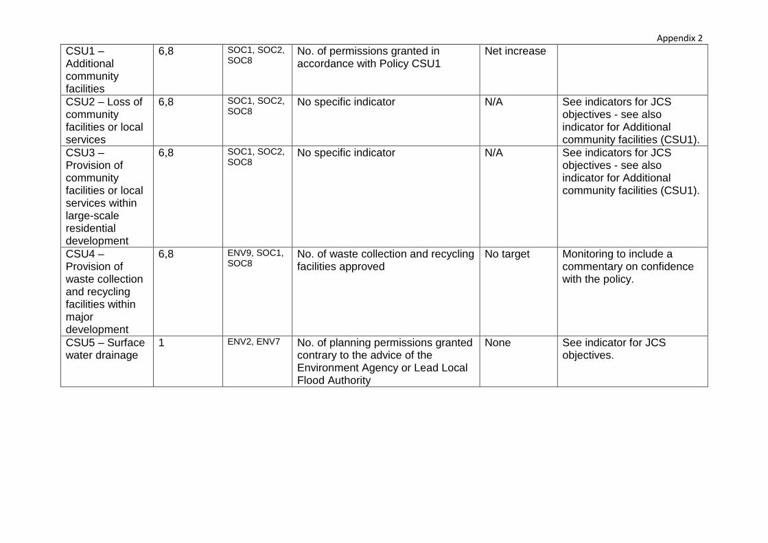
Appendix 2 CSU1 – Additional community facilities
6,8 SOC1, SOC2, SOC8
No. of permissions granted in accordance with Policy CSU1
Net increase
CSU2 – Loss of community facilities or local services
6,8 SOC1, SOC2, SOC8
No specific indicator N/A See indicators for JCS objectives - see also indicator for Additional community facilities (CSU1).
CSU3 – Provision of community facilities or local services within large-scale residential development
6,8 SOC1, SOC2, SOC8
No specific indicator N/A See indicators for JCS objectives - see also indicator for Additional community facilities (CSU1).
CSU4 – Provision of waste collection and recycling facilities within major development
6,8 ENV9, SOC1, SOC8
No. of waste collection and recycling facilities approved
No target Monitoring to include a commentary on confidence with the policy.
CSU5 – Surface water drainage
1 ENV2, ENV7 No. of planning permissions granted contrary to the advice of the Environment Agency or Lead Local Flood Authority
None See indicator for JCS objectives.