Report Template - City of Melville
53
Transcript of Report Template - City of Melville


Murdoch Mixed Use Precinct LandCorp 13-Nov-2015
Murdoch Mixed Use Precinct Transport Assessment

AECOM Murdoch Mixed Use Precinct Murdoch Mixed Use Precinct – Transport Assessment
T:\60445249 - Murdoch MUP\8. Issued Docs\8.1 Reports\151113 Murdoch MUP TA Rev1.docx Revision 1 – 13-Nov-2015 Prepared for – LandCorp – ABN: 34 868 192 835
Murdoch Mixed Use Precinct Transport Assessment
Client: LandCorp
ABN: 34 868 192 835
Prepared by AECOM Australia Pty Ltd 3 Forrest Place, Perth WA 6000, GPO Box B59, Perth WA 6849, Australia T +61 8 6208 0000 F +61 8 6208 0999 www.aecom.com ABN 20 093 846 925
13-Nov-2015
AECOM in Australia and New Zealand is certified to the latest version of ISO9001, ISO14001, AS/NZS4801 and OHSAS18001.
© AECOM Australia Pty Ltd (AECOM). All rights reserved.
AECOM has prepared this document for the sole use of the Client and for a specific purpose, each as expressly stated in the document. No other party should rely on this document without the prior written consent of AECOM. AECOM undertakes no duty, nor accepts any responsibility, to any third party who may rely upon or use this document. This document has been prepared based on the Client’s description of its requirements and AECOM’s experience, having regard to assumptions that AECOM can reasonably be expected to make in accordance with sound professional principles. AECOM may also have relied upon information provided by the Client and other third parties to prepare this document, some of which may not have been verified. Subject to the above conditions, this document may be transmitted, reproduced or disseminated only in its entirety.

AECOM Murdoch Mixed Use Precinct Murdoch Mixed Use Precinct – Transport Assessment
T:\60445249 - Murdoch MUP\8. Issued Docs\8.1 Reports\151113 Murdoch MUP TA Rev1.docx Revision 1 – 13-Nov-2015 Prepared for – LandCorp – ABN: 34 868 192 835
Quality Information Document Murdoch Mixed Use Precinct
Ref 60445249
Date 13-Nov-2015
Prepared by Teresa Matassa, Adeana Khoo
Reviewed by John Macaulay
Revision History
Revision Revision Date Details
Authorised
Name/Position Signature
0 08-Oct-2015 Draft Report for Submission John Macaulay Associate Director
Original signed
1 13-Nov-2015 Final Report John Macaulay Associate Director

AECOM Murdoch Mixed Use Precinct Murdoch Mixed Use Precinct – Transport Assessment
T:\60445249 - Murdoch MUP\8. Issued Docs\8.1 Reports\151113 Murdoch MUP TA Rev1.docx Revision 1 – 13-Nov-2015 Prepared for – LandCorp – ABN: 34 868 192 835
Table of Contents Executive Summary i 1.0 Introduction 3
1.1 Integration with the MAC Development 3 1.2 MUP Transport and Access Objectives 4 1.3 Development Staging 4
2.0 Background 6 2.1 Regional Context 6 2.2 Role of the MUP in the Regional Transport Network 6 2.3 Previous MAC and MUP Transport Studies 9
2.3.1 MAC A Structure Plan (2006, 2008) 9 2.3.2 MUP Development Plan (2009) 9 2.3.3 MAC – Assessment of Transport Impacts (2010) 9 2.3.4 MUP Access Study (2011) 10 2.3.5 MAC Public Transport Master Plan (2010) 10 2.3.6 MUP Traffic Modelling (2012) 10 2.3.7 MUP Transport Assessment (2013) 10 2.3.8 Murdoch Activity Centre Transport Assessment (2015) 10
3.0 Vehicle Movement and Access 12 3.1 Internal Network 12
3.1.1 MUP Street Network Intersection Control 13 3.1.2 Emergency Vehicle Routes 13 3.1.3 Service Vehicle Routes 13
3.2 Road Design 14 3.2.1 Barry Marshall Parade 15 3.2.2 Fiona Wood Road 16 3.2.3 Bedbrook Row 17 3.2.4 Road 1 17 3.2.5 Lot 1 Access Road 18 3.2.6 Lot 7 Access Road 19
3.3 Integration with the External Network 19 3.3.1 MUP Access to the External Road Network 20
3.4 Road Network Improvement Opportunities 21 3.4.1 Perth Freight Link (Roe 8 and Southern Connection) 21 3.4.2 Southern Extension of Fiona Wood Road to Farrington Road 21
4.0 Public Transport Movement 22 4.1 MUP objectives and mode share target 22 4.2 Existing Network 22 4.3 Proposed Network 23
4.3.1 Transit Link along Barry Marshall Parade 24 4.3.2 Pedestrian Connections to Bus and Rail Network 24
4.4 Public Transport Opportunities 25 4.4.1 Future Light Rail Transit Link 25 4.4.2 Free Transit Zone for MAC 26
5.0 Pedestrian and Cycling Movement 27 5.1 MUP Objectives and Mode Share Targets 27 5.2 Existing Network 27 5.3 Proposed Pedestrian Network 28
5.3.1 Pedestrian Linkages 29 5.3.2 Pedestrian Crossing Opportunities 29 5.3.3 Pedestrian Network Opportunities 30
5.4 Proposed Cycling Network 30 5.4.1 Cycling Linkages 30 5.4.2 Cycle Parking 32 5.4.3 Cycle Network Opportunities 32
6.0 Traffic Assessment 33

AECOM Murdoch Mixed Use Precinct Murdoch Mixed Use Precinct – Transport Assessment
T:\60445249 - Murdoch MUP\8. Issued Docs\8.1 Reports\151113 Murdoch MUP TA Rev1.docx Revision 1 – 13-Nov-2015 Prepared for – LandCorp – ABN: 34 868 192 835
6.1 MAC Traffic Modelling Background 33 6.2 Traffic Demands 34
6.2.1 General Approach for MAC 34 6.2.2 Murdoch University including Eastern Precinct 34 6.2.3 Fiona Stanley Hospital and St John of God Hospital 34 6.2.4 Murdoch Station Park n Ride 34 6.2.5 MUP 34 6.2.6 Traffic Generation Summary 35
6.3 Traffic Analysis 36 6.3.1 Intersection Level of Service 36 6.3.2 External Road Network 37 6.3.3 MUP Road Network 37 6.3.4 Pedestrian Crossings at Barry Marshall Parade / Fiona Wood Road 38
6.4 Conclusions 38 6.5 Limitations of Modelling 38
7.0 References 39 Appendix A
Traffic Generation Assumptions A

AECOM Murdoch Mixed Use Precinct Murdoch Mixed Use Precinct – Transport Assessment
T:\60445249 - Murdoch MUP\8. Issued Docs\8.1 Reports\151113 Murdoch MUP TA Rev1.docx Revision 1 – 13-Nov-2015 Prepared for – LandCorp – ABN: 34 868 192 835
i
Executive Summary The Murdoch Mixed Use Precinct (MUP) will provide a transit-orientated hub to support the specialised education and medical activity centre. The MUP site is adjacent to a complex road and rail interchange at Murdoch Station. The adjacent transport corridors constrain the site layout and future traffic generation, but also provide opportunities to achieve a much higher proportion of public transport trips to the site compared to traditional metropolitan developments in Perth. The proposed mix of residential, retail and commercial uses will provide an opportunity to live within walking and cycling distance of major workplaces or tertiary education centres, and to access many daily activities within the site.
The MUP street network and connectivity was developed to meet the following objectives:
- Provide easy and safe access to the bus / rail interchange.
- Provide effective pedestrian linkages through the site.
- Strengthen pedestrian and cycle connectivity to and within the precinct.
- Promote public transport by providing easy, regular and convenient connections.
- Modal split target: 40 per cent Public Transport.
- Low car dependency.
- Transitions from a transit ‘Origin’ to a ‘Destination’ over time.
MUP Street Network
Barry Marshall Parade forms the primary road connection between South Street, Murdoch Drive and the MUP site. It is designed to prioritise transit movements over car movements through the use of bus lanes and the transit only link to Murdoch Station. Barry Marshall Parade provides a sightline between the station and the two major hospitals, with active, landscaped streets encouraging pedestrian movements between these key activities.
The internal road network is intended to provide an attractive, pedestrianised centre with a number of walking and cycling connections to Murdoch Station and through to Fiona Stanley Hospital (FSH). It is designed as a slow-speed environment to provide car, walking and cycling access to the MUP and adjacent hospital activities.
Public Transport Connectivity
People living, working or visiting the MUP are all within a 400 metre walk of either the Barry Marshall Parade bus stops or Murdoch Station bus and rail interchange. This is achieved through the provision of several pedestrian and cycling connections between the MUP and Murdoch Station. The MUP development will almost double the number of residents within the Murdoch Station walking catchment (an additional 1,500 residents expected), but will not add a significant demand for peak hour departures compared to the overall boardings for the Mandurah rail line.
The commercial and retail mix proposed within the MUP will generate counter-flow peak trips for the rail network, and attract commuters travelling through Murdoch Station to the two major hospitals and other adjacent Murdoch Activity Centre (MAC) sites. This will assist with the transition of Murdoch Station to a ‘destination; rather than ‘origin’ station as the MUP development is completed over the next ten years. The proposed reduction in standard car parking rates for the MUP, particularly for commercial and retail employees, will support the proposed target of 40 percent of all MUP trips by public transport.
Walking and Cycling Connectivity
The proposed street network and green corridors within the MUP are designed to attract pedestrian trips through the centre and between local activities. The MUP cycling network is designed to link in with the proposed regional cycling routes through the MAC area. The MUP network includes a direct link to the Principal Shared Path along the Freeway corridor, with either a shared or dedicated cycle lanes provided along the connecting MUP streets, and a shared space design for the short, cul-de-sac lot access roads off Fiona Wood Road and Road 1
Traffic Analysis
AECOM was engaged by the Department of Transport to develop a Commuter microsimulation model for the MAC. The 2031 model includes the entire MAC Structure Plan Area and future planned surrounding road upgrades such as the extension of Roe Highway and associated southern connection as well as the southern
AECOM Murdoch Mixed Use Precinct Murdoch Mixed Use Precinct – Transport Assessment
T:\60445249 - Murdoch MUP\8. Issued Docs\8.1 Reports\151113 Murdoch MUP TA Rev1.docx Revision 1 – 13-Nov-2015 Prepared for – LandCorp – ABN: 34 868 192 835
ii
extension of Fiona Wood Road to Farrington Road. This model was subsequently refined to undertake the detailed traffic analysis for MUP.
The traffic impact assessment is based upon the full build out and occupancy of MUP Stage 1 only. Stage 2 was not modelled due to the uncertainty surrounding the potential relocation of the Murdoch Station western Park n Ride facility, which sits within the Stage 2 development area. Thus the scenario modelled assumes the Park n Ride facility is retained within the MUP Stage 2 site during Stage 1.
The traffic analysis identified a number of issues with the operation of the external road network, particularly at the South Street / Kwinana Freeway interchange and the Murdoch Drive / Farrington Road / New Southern Connection intersection.
It is noted that the MUP development is not considered to be the primary cause of the predicted peak period congestion on the external road network. The MUP parking strategy and objectives to achieve a 40 percent public transport mode share for employees and create a self-sufficient centre all contribute to reducing peak period traffic generated by the MUP development. Vehicle trips generated by the MUP Stage 1 development account for only 10 percent of all vehicle trips into the MAC area.
A significant proportion of the high traffic demands are instead attributed to the wider MAC area. Addressing the predicted traffic demand and corresponding peak period delay at the South Street / Kwinana Freeway interchange should therefore be addressed by the broader MAC transport strategy.
The MUP internal intersections are all predicted to operate satisfactorily.
It is noted that traffic modelling has its limitations. Traffic demands were taken from high level strategic models and as such there is always some level of uncertainty. The results presented in this study should therefore only be viewed as an indication of what may occur in the future.
Transport Network Improvement Opportunities
There are a number of opportunities to improve the MAC transport network, including:
- Roe Highway Extension and new connection to Murdoch Drive (southern connection)
- Southern extension of Fiona Wood Road to Farrington Road.
- Relocation of the western Park n Ride Facility (potentially to a multi-storey carpark on the eastern side of Kwinana Freeway).
- Murdoch Station bus bridge capacity improvement.
- Light Rail Transit link through the MUP to Murdoch Station.
- Free Transit Zone for MAC
- Pedestrian and cycling crossing improvements for South Street and Murdoch Drive.
- Direct pedestrian and cycling connection between catchments on the eastern side of Kwinana Freeway (Leeming and Bull Creek) and the MUP and wider MAC site such as via a pedestrian bridge which also connects to Murdoch Station.
- Bike hire scheme for MAC
These network options are to be further investigated as part of the broader MAC planning process. The MUP site has been developed to enable these opportunities to be realised if these initiatives are progressed in the future.

AECOM Murdoch Mixed Use Precinct Murdoch Mixed Use Precinct – Transport Assessment
T:\60445249 - Murdoch MUP\8. Issued Docs\8.1 Reports\151113 Murdoch MUP TA Rev1.docx Revision 1 – 13-Nov-2015 Prepared for – LandCorp – ABN: 34 868 192 835
3
1.0 Introduction The Murdoch Mixed Use Precinct (MUP) provides an opportunity to develop a transit-orientated hub in a growing strategic activity centre. The MUP will support the specialised Murdoch health and tertiary education centre, providing a range of daily activities, including student and residential dwellings, within walking and cycling distance of other key activities. The MUP site is adjacent to a complex road and rail interchange at Murdoch Station. The adjacent transport corridors constrain the site layout and future traffic generation, but also provide opportunities to achieve a much higher proportion of public transport trips to the site compared to traditional metropolitan developments in Perth.
This report outlines the proposed movement strategy for the MUP, identifying multi-modal access opportunities and the predicted traffic impact of the MUP activities. The information included in this report meets the transport assessment requirements outlined in the Transport Assessment Guidelines for Developments, Volume 2 – Structure Plans (Western Australian Planning Commission (WAPC), 2006).
1.1 Integration with the MAC Development The MUP development is one of a number of growth precincts within Murdoch Activity Centre (MAC), as illustrated in Figure 1. On the southern boundary of the MUP is the significant Fiona Stanley Hospital (FSH) development, one of the largest State Government developments in recent times. To the west, the MUP site is bounded by St John of God Hospital (SJOGH) which has recently undergone an expansion adding 174 more beds. These major trip generators will utilise part of the MUP transport network for site access and connectivity to the regional road network and have been a key consideration in the MUP transport network design. In addition, half of the MUP site is currently occupied by Murdoch Station Park n Ride facility. The management and potential relocation of this facility is the responsibility of the Public Transport Authority, and has also been an important consideration of the MUP and broader MAC transport planning process. Figure 1 MAC Sub-Precincts (Department of Planning, 2014)
The MUP development has been progressed through close liaison with MAC stakeholders, particularly the Department of Health and SJOGH management, Department of Planning, Department of Transport, Main Roads Western Australia, Public Transport Authority, City of Melville and Murdoch University. The MUP development has sought guidance on transport strategies from the MAC structure planning process, aligning with the objectives and

AECOM Murdoch Mixed Use Precinct Murdoch Mixed Use Precinct – Transport Assessment
T:\60445249 - Murdoch MUP\8. Issued Docs\8.1 Reports\151113 Murdoch MUP TA Rev1.docx Revision 1 – 13-Nov-2015 Prepared for – LandCorp – ABN: 34 868 192 835
4
recommendations of the Murdoch Specialised Activity Centre Structure Plan (WAPC & Department of Planning, January 2014).
As the MAC structure planning process is still underway, there are a number of transport issues which are still to be resolved, such as:
- Potential relocation of Murdoch Station western Park n Ride facility.
- Potential extension of Fiona Wood Road south of MUP and FSH, to relieve traffic congestion on Barry Marshall Parade, Murdoch Drive and South Street.
- Bus capacity at the Murdoch Station bus and rail interchange.
- Long term transit provision through MAC (and MUP).
These issues affect access and connectivity to and through the MUP, but are outside of the scope of the MUP development and are instead to be resolved through the MAC planning process. This transport assessment is based on the current status of committed transport network upgrades, which are outlined in Section 3.0. Where network improvement options are still under investigation through the broader MAC process, these initiatives are noted as opportunities in this movement strategy. The MUP site has been developed to enable these opportunities to be realised if these initiatives are progressed in the future.
1.2 MUP Transport and Access Objectives The importance of the movement and access strategy to the success of the development is emphasised by the number of transport objectives included in the MUP vision:
- Provide easy and safe access to the bus / rail interchange.
- Provide effective pedestrian linkages through the site.
- Strengthen pedestrian and cycle connectivity to and within the precinct.
- Promote public transport by providing easy, regular and convenient connections.
- Modal split target: 40 per cent Public Transport.
- Low car dependency.
- Transitions from a transit ‘Origin’ to a ‘Destination’ over time.
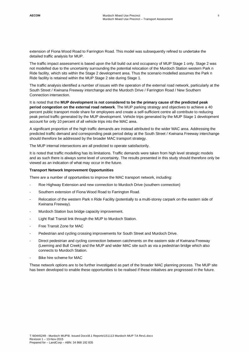
1.3 Development Staging The MUP is proposed to be developed in two stages for commercial reasons and to integrate with other developments affecting the site. The proposed development staging for the MUP is illustrated in Figure 2.
AECOM Murdoch Mixed Use Precinct Murdoch Mixed Use Precinct – Transport Assessment
T:\60445249 - Murdoch MUP\8. Issued Docs\8.1 Reports\151113 Murdoch MUP TA Rev1.docx Revision 1 – 13-Nov-2015 Prepared for – LandCorp – ABN: 34 868 192 835
5
Figure 2 Staging Plan (LandCorp, 2015)
The timing of the MUP and adjacent developments is summarised below.
- Stage 1
MUP Stage 1 civil works to be completed by mid-2017.
Murdoch Park n Ride facility within the MUP site is retained, with new access via the MUP street network.
- Stage 2
Although the Murdoch Station western Park n Ride facility lease agreement expires in 2017; commencement of Stage 2 is subject to relocation of the existing Park n Ride which will only occur when there is agreement on a suitable option by all relevant government stakeholders including Main Roads, Department of Transport (DoT) and Public Transport Authority (PTA).
There are also a number of upgrades for the adjacent regional road network to be completed within these timeframes and these are outlined in Section 3.0.
AECOM Murdoch Mixed Use Precinct Murdoch Mixed Use Precinct – Transport Assessment
T:\60445249 - Murdoch MUP\8. Issued Docs\8.1 Reports\151113 Murdoch MUP TA Rev1.docx Revision 1 – 13-Nov-2015 Prepared for – LandCorp – ABN: 34 868 192 835
6
2.0 Background This section outlines the role of the MUP within the strategic MAC development, and transport strategies influencing the MAC regional road and public transport network. A summary is also provided of previous studies investigating constraints and opportunities to improve the long-term capacity of the MAC transport network.
2.1 Regional Context Under Directions 2031 and Beyond (WAPC, 2010), the Murdoch Activity Centre is planned as a specialised activity centre. Specialised activity centres house regionally significant activities, with the health and education functions in Murdoch attracting trips from across the metropolitan area, as well as broader regional and state centres. The MUP is a key development site within the MAC area, supporting the centre to become self-sufficient through new residential, commercial and retail development (thereby encouraging walking and cycling trips for a range of daily activities) and providing an important link to multi-modal regional transport networks.
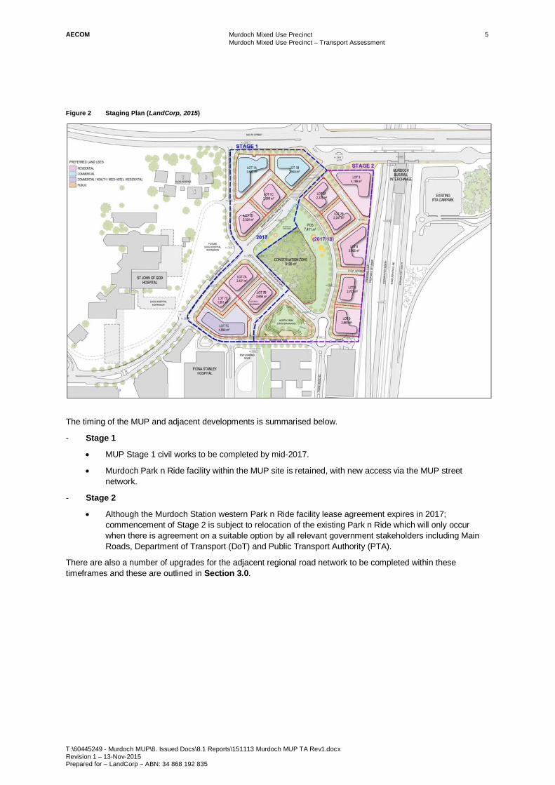
Figure 3 illustrates the location of MUP within the MAC area and in relation to other strategic centres in Perth. Figure 3 MUP Location and Regional Context (Department of Planning, 2014)
2.2 Role of the MUP in the Regional Transport Network The location of the MUP immediately adjacent to Murdoch Station and Kwinana Freeway provides a direct rail and regional road link to Perth Central Business District (CBD), as well as the north-south strategic metropolitan centres of Joondalup and Mandurah. The proximity of the MUP to the Mandurah rail line also provides access to the metropolitan wide train services, through the Perth CBD connection to the Fremantle, Armadale and Midland rail lines. South Street on the northern boundary of the site provides a primary east-west road link between the strategic centres of Fremantle, Murdoch and residential and industrial areas in the east. South Street experiences congestion at peak times with heavy demands from traffic accessing the Freeway, as well as regional freight and commuter through-movements. The movement strategy for the MUP recognises the capacity limitations of the regional road network, aiming for a significant increase in the proportion of MAC public transport trips and an increase in local walking and cycling trips between MAC activities.
To Perth CBD and Joondalup
To Mandurah
To Fremantle To Canning Vale industrial area
MUP
MAC area

AECOM Murdoch Mixed Use Precinct Murdoch Mixed Use Precinct – Transport Assessment
T:\60445249 - Murdoch MUP\8. Issued Docs\8.1 Reports\151113 Murdoch MUP TA Rev1.docx Revision 1 – 13-Nov-2015 Prepared for – LandCorp – ABN: 34 868 192 835
7
The State Planning Policy (SPP) 4.2 – Activity Centres for Perth and Peel (WAPC, 2010) requires access by public transport, walking and cycling to be prioritised over private car access for specialised activities centres. Additional guidance for the MUP development is provided in Development Control Policy (DCP) 1.6 Planning to Support Transit Use and Transit Orientated Development (WAPC, 2006). The MUP provides for high trip generating commercial and residential development within 800 metres walk of Murdoch Station and high frequency bus or transit routes. Achieving a high proportion of walking, cycling or public transport trips between MUP and other key MAC precincts is an objective of the proposed MUP development, with the attractiveness, ease and convenience of these priority transport modes key design features. The location and supply of parking for MUP and wider MAC activities (including Murdoch Station Park n Ride) will strongly influence travel choices to and within the site.
The Draft Public Transport for Perth in 2031 (Department of Transport, 2011) includes the development of a Bus Rapid Transit link between Fremantle, Murdoch and Cannington to improve east-west connectivity between these strategic centres, as outlined in Figure 4. Figure 4 Public Transport Plan for Perth by 2031 (Department of Transport, 2011)

AECOM Murdoch Mixed Use Precinct Murdoch Mixed Use Precinct – Transport Assessment
T:\60445249 - Murdoch MUP\8. Issued Docs\8.1 Reports\151113 Murdoch MUP TA Rev1.docx Revision 1 – 13-Nov-2015 Prepared for – LandCorp – ABN: 34 868 192 835
8
The draft Murdoch Structure Plan recommends additional public transport improvements to enable the MUP and broader MAC site to fulfil their growth potential whilst achieving the target modal shift towards at least 40 per cent of trips by public transport. The desired regional public transport connections for MAC are illustrated in Figure 5. Figure 5 MAC Desired Regional Public Transport Connections (Department of Planning and WAPC, 2014)
The draft Murdoch Structure Plan recommends an extension of the State Government’s proposed Light Rail Transit (LRT) system south to Murdoch, connecting to the other strategic health and education centres in the Perth metropolitan area. Extending the LRT along the east-west route between Fremantle and Cannington (or Armadale) is also recommended to greatly improve public transport accessibility to the residential catchments along South Street. The recommended MAC public transport routes are illustrated in Figure 6. The internal MUP transport network has been designed to accommodate a future LRT connection, increasing the attractiveness and capacity of public transport access in the longer term.

AECOM Murdoch Mixed Use Precinct Murdoch Mixed Use Precinct – Transport Assessment
T:\60445249 - Murdoch MUP\8. Issued Docs\8.1 Reports\151113 Murdoch MUP TA Rev1.docx Revision 1 – 13-Nov-2015 Prepared for – LandCorp – ABN: 34 868 192 835
9
Figure 6 Recommended Principal Public Transport Routes for Murdoch Activity Centre (Department of Planning and WAPC, 2014)
2.3 Previous MAC and MUP Transport Studies 2.3.1 MAC A Structure Plan (2006, 2008)
A Structure Plan was previously prepared for a much smaller MAC A area, which only included the MUP site, FSH, SJOGH, Challenger TAFE and a small eastern portion of Murdoch University (Department of Planning and Department of Health, 2007). As part of the initial planning for FSH, several traffic studies for the area were undertaken, including the Southern Tertiary Health Precinct Transport Plan Report (SKM, 2006) and Southern Tertiary Health Precinct Transport Model Update (SKM, 2008). These transport studies modelled road network options to improve the long-term peak network capacity, particularly at the South Street and Murdoch Drive intersections within the MAC A site. These studies included a 50 per cent public transport, walking and cycling mode share for major MAC activities. The MAC A road network was based on the recommended network improvements, with a new southern Freeway connection provided between Murdoch Drive and Roe Highway East, and an extension of Fiona Wood Road through to Farrington Road.
2.3.2 MUP Development Plan (2009)
A previous development plan for the MUP was prepared in 2009 (Department of Planning and GHD, 2009). This plan allowed for a significant site development, ultimately up to 17 stories and 320,000 square metres of development floorspace, although the traffic impact of the ultimate development was not assessed in detail. The 2009 MUP plan also included extensive underground parking which is no longer considered commercially viable. To improve access to the MUP site and bypass congested South Street intersections, the 2009 MUP Business Case recommended the construction of a tunnel to provided direct access between the Freeway and the MUP car park facilities. As well as improving the capacity of the road network, the new MUP access option was proposed to increase the attractiveness and development value of the MUP site.
2.3.3 MAC – Assessment of Transport Impacts (2010)
The Murdoch Activity Centre – Assessment of Transport Impacts (ARRB, 2010) was based on a smaller scale of the 2009 MUP development plan. For the MUP site, the ARRB study included 1,975 jobs and 935 residents by 2021 and ultimately 3,970 jobs and 1,870 residents by 2031 (compared to an ultimate supply of 4,800 jobs and 1,100 dwellings for the current MUP plan). This report included a 60 per cent public transport, walking and cycling

AECOM Murdoch Mixed Use Precinct Murdoch Mixed Use Precinct – Transport Assessment
T:\60445249 - Murdoch MUP\8. Issued Docs\8.1 Reports\151113 Murdoch MUP TA Rev1.docx Revision 1 – 13-Nov-2015 Prepared for – LandCorp – ABN: 34 868 192 835
10
mode share for the MUP site. The assessment tested additional transport network options to improve the long term regional road capacity, including the extension of Roe Highway to form a new southern Freeway connection and the grade separation of Murdoch Drive and South Street intersection. One of the major transport recommendations from this report was to constrain future car parking across the MAC to balance the future traffic demand and the available road network capacity, and to achieve the target public transport mode share. The recommendations on the long term (2031) transport network capacity formed the basis of the proposed maximum parking cap of 17,000 non-residential bays across the MAC area outlined in the Murdoch Activity Centre Interim Access and Parking Policy (WAPC, 2011).
2.3.4 MUP Access Study (2011)
In 2011, a more detailed study of the potential benefits for constructing a direct tunnel link between the MUP and Kwinana Freeway was undertaken (MUP Access Study, AECOM, 2011). The tunnel options provided direct access to and from the MUP and the northbound Freeway corridor. Other network improvement options considered in this study were southern connections between Murdoch Drive and the Freeway (connection to the Freeway only, as well as options connecting to the Freeway and east to Roe Highway) and a ‘right turn’ out of the MUP site from Fiona Wood Road onto South Street. The study outcomes recommended the construction of the southern connection to the Freeway and Roe Highway and the ‘right turn’ from Fiona Wood Road to South Street instead of the MUP tunnel construction, as these options were likely to deliver greater congestion benefits. However the study noted the design feasibility of the ‘right turn’ from Fiona Wood Road needed to be confirmed through further investigation.
2.3.5 MAC Public Transport Master Plan (2010)
The Murdoch Activity Centre Public Transport Master Plan (Worley Parsons, 2010) focused on the future demand for public transport services. The Main Roads Regional Operations Model (ROM) used in the other MAC traffic studies does not explicitly incorporate public transport movements, and an empirical model formula was used to forecast the future public transport demand. The Worley Parsons study was based on the MAC A proposed road network (including the extension of Fiona Wood Road to Farrington Road and a partial southern connection to the Freeway from Murdoch Drive). The study included a 35 per cent mode share for public transport (15 per cent for walking and cycling), and an ultimate of 4,000 jobs and 2,000 dwellings in the MUP site (similar to the ARRB study). The Worley Parsons study assumed the retention of the existing public transport network, allowing for increased services and new bus routes to meet the forecast future MAC demand. The study recommended the construction of a transit link from the MAC to Murdoch Station (via the MUP) as a priority, with public transport priority over general traffic along the transit link. The study also recommended consideration of car parking revenue as a funding source for future public transport initiatives.
2.3.6 MUP Traffic Modelling (2012)
In 2012, a number of recent traffic impact studies were undertaken to test different MUP street network options, FSH and SJOGH parking management and development options, and the Murdoch Station Park n Ride relocation options (Urbsol 2012a, 2012b and 2012c). The studies were based on a detailed Commuter model for the MUP and adjacent hospital precinct, and have been informed by the current MAC structure planning process and recent development plans for the MUP site. The regional road network included in the Commuter modelling incorporates recent network improvements (Kwinana Freeway widening, South Street and Murdoch Drive intersection widening), however did not include network improvement options that were recommended in previous studies but uncommitted at the time, namely the southern connection of Murdoch Drive to Kwinana Freeway and Roe Highway, and the southern extension of Fiona Wood Road to Farrington Road.,
2.3.7 MUP Transport Assessment (2013)
The previous development plan for MUP was prepared in 2013, Traffic analysis undertaken for this Transport Assessment was based on the Commuter modelling undertaken by Urbsol in 2012 to assess the operation of the wider area and external road network, with SIDRA used to assess the individual operation of key intersections within the vicinity of the MUP,
2.3.8 Murdoch Activity Centre Transport Assessment (2015)
AECOM, in collaboration with Flyt, is currently undertaking a transport study for the Department of Transport for the wider MAC study area, including traffic modelling for 2031, and reviews of the Car Parking Policy and Public Transport Master Plan. This study uses a three-tiered approach to modelling for the activity centre, with macroscopic modelling being undertaken using the Department of Transport’s strategic model STEM, mesoscopic modelling using SATURN and microscopic modelling using Commuter. The 2031 project road network being

AECOM Murdoch Mixed Use Precinct Murdoch Mixed Use Precinct – Transport Assessment
T:\60445249 - Murdoch MUP\8. Issued Docs\8.1 Reports\151113 Murdoch MUP TA Rev1.docx Revision 1 – 13-Nov-2015 Prepared for – LandCorp – ABN: 34 868 192 835
11
modelled includes the extension of Roe Highway and the associated southern connection to Murdoch Drive, as well as the southern extension of Fiona Wood Road through to Farrington Road,

AECOM Murdoch Mixed Use Precinct Murdoch Mixed Use Precinct – Transport Assessment
T:\60445249 - Murdoch MUP\8. Issued Docs\8.1 Reports\151113 Murdoch MUP TA Rev1.docx Revision 1 – 13-Nov-2015 Prepared for – LandCorp – ABN: 34 868 192 835
12
3.0 Vehicle Movement and Access The MUP site is located adjacent to the complex Murdoch Station, South Street and Kwinana Freeway interchange as illustrated in Figure 7. The MUP site is undeveloped, except for the Murdoch Station Park n Ride facility (to be relocated in Stage 2).
The proposed internal street network for the ultimate MUP development is detailed in this section. The proposed connectivity between the MUP and the regional road network is also outlined in this section, and the MUP integration with adjacent developments and road network improvement projects. Figure 7 Regional/District Road Network around MUP
3.1 Internal Network The MUP street network and indicative site access points are illustrated in Figure 8. The proposed street network is characterised by the main transit and vehicle through-route along Barry Marshall Parade, with a dispersed, slower street network radiating from the local distributor roads south of Barry Marshall Parade, namely Fiona Wood Road and the arc road east of the conservation zone (referred to as Road 1). The intent of the street network is to provide an efficient transit link through the site linked directly to Murdoch bus and rail interchange, and connecting through to FSH, SJOGH and other key MAC trip generators to the west. Barry Marshall Parade also provides a sightline between the station, FSH and SJOGH with active, landscaped street frontage encouraging pedestrian movements between these key activities.
The MUP internal road network compliments the pedestrianised, people-focused centre of MUP. Road 1 in particular, is unlikely to attract through-traffic, instead trafficked by slower speed vehicles accessing MUP development sites.
It is likely that Bedbrook Row will carry larger volumes of traffic, as it provides access to the FSH staff and visitor car parks. Bedbrook Row includes central islands to assist with traffic flow and pedestrian crossing movements.

AECOM Murdoch Mixed Use Precinct Murdoch Mixed Use Precinct – Transport Assessment
T:\60445249 - Murdoch MUP\8. Issued Docs\8.1 Reports\151113 Murdoch MUP TA Rev1.docx Revision 1 – 13-Nov-2015 Prepared for – LandCorp – ABN: 34 868 192 835
13
The remaining internal MUP roads are characterised as short, low volume streets providing access to specific development sites. Figure 8 MUP Street Network and Indicative Site Access
Base plan: Murdoch MUP Preliminary Site Plan (ARM Architecture, 10 July 2015)
3.1.1 MUP Street Network Intersection Control
Barry Marshall Parade provides the primary traffic route to and from the MUP network. The intersection with Fiona Wood Road is signalised, with the signals including pedestrian phases and bus pre-emptive priority phases.
The Barry Marshall Parade / Bedbrook Row intersection is proposed to remain unsignalised. Bedbrook Row provides access to FSH drop-off visitor parking and to the major staff and visitor car parks off Fiona Wood Road South. The intersection of Bedbrook Row and Fiona Wood Road South is proposed to remain controlled as a single-lane roundabout.
The predicted performance of the intersections during peak times are detailed in Section 6.0.
3.1.2 Emergency Vehicle Routes
The primary emergency vehicle route to Fiona Stanley Hospital does not intercept the MUP street network as it is via Murdoch Drive and Robin Warren Drive. There is a contingency Hospital emergency access agreed in principle with the Public Transit Authority (PTA) if access along South Street or Murdoch Drive is restricted. This contingency route is through Murdoch Station bus and rail interchange onto Barry Marshall Parade, Bedbrook Road and Fiona Wood Road (south). The proposed Barry Marshall Parade transit link will enable this contingency access route, with emergency vehicles able to use the priority bus lanes (and pre-emptive priority signals).
3.1.3 Service Vehicle Routes
The main service vehicle access for FSH is via a service road off Bedbrook Row located within Site 7, providing access to the FSH underground car park. The FSH car park is designed primarily for 12.5 metre long delivery vehicles, and also caters for less frequent semi-trailer access. This service road is designed for these service vehicles. Other streets within the MUP development allow for larger service vehicles (semi-trailers) access, assuming these will be infrequent movements permissible without being lane correct.
Legend
MUP Site Traffic Signals Roundabout Transit Link
MUP site access Non-MUP site access

AECOM Murdoch Mixed Use Precinct Murdoch Mixed Use Precinct – Transport Assessment
T:\60445249 - Murdoch MUP\8. Issued Docs\8.1 Reports\151113 Murdoch MUP TA Rev1.docx Revision 1 – 13-Nov-2015 Prepared for – LandCorp – ABN: 34 868 192 835
14
3.2 Road Design Typical cross-sections for the MUP streets are detailed in this section. These are taken from drawings issued by BG&E (Drawing CSK400 Revision A). The cross-section of the major access roads (Fiona Wood Road North, Barry Marshall Parade and Bedbrook Row) are designed to provide adequate intersection capacity to meet the predicted peak hour traffic flows detailed in Section 6. The cross-sections for the smaller access roads are designed to encourage slower speed traffic accessing local on-street or off-street parking facilities. A maximum speed limit of 40 kilometres per hour (km/h) is proposed for all roads within the MUP network to facilitate the safe integration of all road users.
The location of each cross-section is shown in Figure 9. Figure 9 Location of Cross-sections
Base plan: Murdoch MUP Preliminary Site Plan (ARM Architecture, 10 July 2015)

AECOM Murdoch Mixed Use Precinct Murdoch Mixed Use Precinct – Transport Assessment
T:\60445249 - Murdoch MUP\8. Issued Docs\8.1 Reports\151113 Murdoch MUP TA Rev1.docx Revision 1 – 13-Nov-2015 Prepared for – LandCorp – ABN: 34 868 192 835
15
3.2.1 Barry Marshall Parade
The existing cross-section for Barry Marshall Parade south and north of Fiona Wood Road are shown in Figure 10 and Figure 11 respectively. The road includes wide footpaths, dedicated cycle lanes and a median. South of Fiona Wood Road, Barry Marshall Parade has a single traffic lane, a shared bus/cycle lane and on-street parking in both directions. North of Fiona Wood Road, the road is a bus only link, with a dedicated bus lane provided in both directions. Traffic lanes are also provided to allow for future access to the MUP Stage 2 development. The intersection layouts are functional for a local road through a major activity centre, which encourages pedestrian permeability and local access. Figure 10 Cross-section 1: Barry Marshall Parade – South of Fiona Wood Road
Figure 11 Cross-section 2: Barry Marshall Parade – North of Fiona Wood Road
AECOM Murdoch Mixed Use Precinct Murdoch Mixed Use Precinct – Transport Assessment
T:\60445249 - Murdoch MUP\8. Issued Docs\8.1 Reports\151113 Murdoch MUP TA Rev1.docx Revision 1 – 13-Nov-2015 Prepared for – LandCorp – ABN: 34 868 192 835
16
3.2.2 Fiona Wood Road
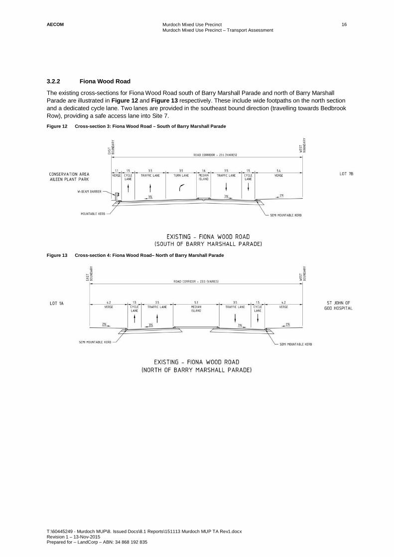
The existing cross-sections for Fiona Wood Road south of Barry Marshall Parade and north of Barry Marshall Parade are illustrated in Figure 12 and Figure 13 respectively. These include wide footpaths on the north section and a dedicated cycle lane. Two lanes are provided in the southeast bound direction (travelling towards Bedbrook Row), providing a safe access lane into Site 7. Figure 12 Cross-section 3: Fiona Wood Road – South of Barry Marshall Parade
Figure 13 Cross-section 4: Fiona Wood Road– North of Barry Marshall Parade

AECOM Murdoch Mixed Use Precinct Murdoch Mixed Use Precinct – Transport Assessment
T:\60445249 - Murdoch MUP\8. Issued Docs\8.1 Reports\151113 Murdoch MUP TA Rev1.docx Revision 1 – 13-Nov-2015 Prepared for – LandCorp – ABN: 34 868 192 835
17
3.2.3 Bedbrook Row
The existing cross-section for Bedbrook Row is illustrated in Figure 14. The road has one shared traffic and cycle lane in each direction, with wide verges and a median provided for crossing pedestrians. Figure 14 Cross-section 5: Bedbrook Row – Approach to Barry Marshall Parade
3.2.4 Road 1
The proposed cross-sections for the north and south sections of Road 1 are illustrated in Figure 15 and Figure 16. The northern section is one way only, consisting of a shared traffic and cycle lane directing traffic northbound onto Barry Marshall Parade. The southern section has one shared traffic and cycle lane in each direction, permitting access onto Fiona Wood Road and Bedbrook Row. The slow-speed road environment will support more confident cyclists sharing the traffic lanes with vehicles. On-street parking is proposed to be provided along Road 1. Figure 15 Cross-section 6: Road 1 North

AECOM Murdoch Mixed Use Precinct Murdoch Mixed Use Precinct – Transport Assessment
T:\60445249 - Murdoch MUP\8. Issued Docs\8.1 Reports\151113 Murdoch MUP TA Rev1.docx Revision 1 – 13-Nov-2015 Prepared for – LandCorp – ABN: 34 868 192 835
18
Figure 16 Cross-section 7: Road 1 South
3.2.5 Lot 1 Access Road
The proposed cross-section for the access road to Lot 1 is illustrated in Figure 17. The road reserve is 13.0 metres wide with a shared traffic/cycle lane in each direction, given the low volumes and slow-speed environment expected on this access road. Figure 17 Cross-section 8: Lot 1 Access Road

AECOM Murdoch Mixed Use Precinct Murdoch Mixed Use Precinct – Transport Assessment
T:\60445249 - Murdoch MUP\8. Issued Docs\8.1 Reports\151113 Murdoch MUP TA Rev1.docx Revision 1 – 13-Nov-2015 Prepared for – LandCorp – ABN: 34 868 192 835
19
3.2.6 Lot 7 Access Road
The proposed cross-section for the access road to Lot 7 is illustrated in Figure 18. The road reserve is 15.0 metres wide with a shared traffic/cycle lane in each direction, given the low volumes and slow-speed environment expected on this access road. Figure 18 Cross-section 9: Lot 7 Access Road
3.3 Integration with the External Network A number of traffic studies have previously been undertaken to assess existing and future capacity constraints on the regional road network surrounding the MUP, as outlined in Section 2.3. These traffic studies considered the impact of more significant traffic generators within MAC (FSH, SJOGH) as well as the MUP development.
There have been a number of upgrades to the road network in the vicinity of MUP in recent years. These include:
- Widening of the Kwinana Freeway (Leach Highway to Roe Highway) – completed in 2013: The project involved widening Kwinana Freeway to three lanes in each direction between Leach Highway and Roe Highway.
- Relocation of the Kwinana Freeway northbound to South Street off-ramp – completed in 2013: The off-ramp was relocated to access South Street from the north side to allow for construction of the transit connection from Barry Marshall Parade to Murdoch rail / bus interchange. This will also enable future development of Stage 2 of MUP.
- Murdoch Drive / South Street intersection upgrade – completed in 2014: Widening of the whole intersection was undertaken to provide an additional right turning lane from Murdoch Drive northbound onto South Street eastbound (for traffic exiting the MUP / MAC heading towards the Freeway and eastern South Street catchments), and an additional right turning lane from South Street eastbound onto Murdoch Drive northbound.
The upgrade of the Murdoch Drive / South Street intersection in particular has seen a significant reduction in the level of congestion experienced in the peak periods. However, there are still a number of pinch points in the road network, particularly the Kwinana Freeway / South Street interchange and the Murdoch Drive / Farrington Road roundabout.

AECOM Murdoch Mixed Use Precinct Murdoch Mixed Use Precinct – Transport Assessment
T:\60445249 - Murdoch MUP\8. Issued Docs\8.1 Reports\151113 Murdoch MUP TA Rev1.docx Revision 1 – 13-Nov-2015 Prepared for – LandCorp – ABN: 34 868 192 835
20
3.3.1 MUP Access to the External Road Network
The main MUP access points are Fiona Wood Road and Barry Marshall Parade, as illustrated in Figure 19. Figure 19 MUP External Road Access Points
Base plan: Murdoch MUP Preliminary Site Plan (ARM Architecture, 10 July 2015)
Fiona Wood Road (north) provides a left in, left out access between the MUP and South Street, servicing traffic exiting the freeway, traffic coming from catchments east of Kwinana Freeway and exiting traffic heading west. Fiona Wood Road is a main entrance, with a signalised intersection with Barry Marshall Parade placed to provide adequate queuing space for traffic heading into the MUP and west to FSH.
Barry Marshall Parade links FSH, SJOG and the MUP to Murdoch Drive, a district distributor road. This provides a connection to western catchments via South Street as well as northern and southern catchments within the City of Melville and City of Cockburn. The intersection of Murdoch Drive and South Street, which has recently been upgraded, accommodates all other movements not possible at the Fiona Wood Road north left in, left out access.
The impact of the MUP traffic on the traffic flows along South Street, Murdoch Drive and at the Freeway interchange is discussed in Section 6.0.

AECOM Murdoch Mixed Use Precinct Murdoch Mixed Use Precinct – Transport Assessment
T:\60445249 - Murdoch MUP\8. Issued Docs\8.1 Reports\151113 Murdoch MUP TA Rev1.docx Revision 1 – 13-Nov-2015 Prepared for – LandCorp – ABN: 34 868 192 835
21
3.4 Road Network Improvement Opportunities There are several options identified in many of the MAC transport studies which could improve the long-term road network capacity adjacent to the MUP site.
3.4.1 Perth Freight Link (Roe 8 and Southern Connection)
At this stage the State Government has committed to the Perth Freight Link Section 1 road upgrade, which includes the extension of Roe Highway (Roe 8) and a new connection to Murdoch Drive (southern connection), as shown in Figure 20.
The extension of Roe Highway would provide regional benefits for freight movements in addition to the connectivity benefits for the Murdoch area. The southern connection will provide an additional Freeway access option for vehicles from the southern catchment, directing traffic away from and easing pressure on the South Street corridor and the congested Freeway interchange. Figure 20 Perth Freight Link Section 1 (Roe 8)
Source: Main Roads Projects – Roe Highway Extension
3.4.2 Southern Extension of Fiona Wood Road to Farrington Road
Previous studies of the long-term MAC road network have included the extension of Fiona Wood Road south to Farrington Road with the replacement of the existing Kwinana Freeway northbound on-ramp at Farrington Road with a new loop ramp. This link road would provide an additional access route from the MUP and FSH onto the northbound freeway corridor via Farrington Road. This could potentially divert traffic away from Barry Marshall Parade, Murdoch Drive and South Street relieving peak hour congestion and delay, and reducing conflict with the transit and pedestrian priorities of the MUP network.
The construction of this road is identified as a priority for the medium-term (by 2021) in the Murdoch Specialised Activity Centre Structure Plan report.

AECOM Murdoch Mixed Use Precinct Murdoch Mixed Use Precinct – Transport Assessment
T:\60445249 - Murdoch MUP\8. Issued Docs\8.1 Reports\151113 Murdoch MUP TA Rev1.docx Revision 1 – 13-Nov-2015 Prepared for – LandCorp – ABN: 34 868 192 835
22
4.0 Public Transport Movement The MUP is being developed to capitalise on the ease of access to Murdoch Station, with a target for public transport to be used for a larger proportion of trips (40 per cent) than driving a vehicle (around 35 per cent of trips). The proposed infrastructure connections and initiatives to encourage public transport use for the MUP are outlined in this section.
4.1 MUP objectives and mode share target
The relevant MUP objectives for public transport access are:
- Provide easy and safe access to the bus / rail interchange.
- Promote public transport by providing easy, regular and convenient connections.
- Modal split target: 40 per cent Public Transport.
- Transitions from a transit ‘Origin’ to a ‘Destination’ over time.
The target public transport mode share of 40 per cent is considered feasible due to the proximity of MUP to Murdoch Station and the public transport and parking measures outlined in the following sections. This target is consistent with the proposed 40 per cent public transport mode share across the MAC site.
Each site in the MUP is located at a distance of 400 metres or less from Murdoch Station, well within the 800 metre walking catchment, providing an opportunity for the site to be transformed as a Transit Orientated Development (TOD). A general objective of TOD is to increase the residential density within a 10 minute walk (800 metres) of major bus or train stations (DCP 1.6 Planning to Support Transit Use and Transit Orientated Development, WAPC, 2006). A particular focus for this TOD is to grow the precinct into a destination (rather than origin) of public transport trips. To achieve this objective a large proportion of the MUP site is to be allocated to commercial activities and supporting retail / hospitality uses (forecast 2,430 jobs). These MUP activities could generate counter flow peak trips on the rail network, assisting to create a more balanced rail demand and achieving broader PTA objectives.
The MUP will provide an additional 910 to 1,230 residential dwellings within the station walking catchment, depending on whether a medium or high yield scenario is developed. This will almost double the current number of residential dwellings within the walkable catchment1 but will not add a significant demand for peak hour departures compared to the overall boardings for the Mandurah rail line (a total of almost 40,000 boardings per day in 20131). It is assumed the long-term peak period capacity will increase through the purchase of additional railcars as outlined in the Draft Public Transport for Perth in 2031 (DoT, 2011). In addition, a number of the residential dwellings are targeted at the local student population and local MAC employees, minimising the peak hour demand for residents commuting to other activity centres.
4.2 Existing Network The Murdoch MUP is well serviced by the public transport network, being located adjacent to Murdoch Station, the busiest Transperth interchange outside the Perth CBD. Murdoch Station is serviced by the Mandurah train line, which runs between Perth and Mandurah with an average five minute frequency during peak hours, and every 15 minutes in the afternoons and evenings. The placement of Murdoch station in the centre of a large transport interchange currently reduces the number of people living within the walking or cycling catchment area, with the majority of rail passengers currently arriving by car (30 per cent) or bus (60 per cent) (Presentation by Peter Martinovich, 2011 SMART Urban Transport Conference).
Reflecting the important role of bus feeder routes to the Murdoch Station rail patronage, the interchange is well serviced by 21 bus routes, illustrated in Figure 21. These buses connect Murdoch to a number of suburbs including Bull Creek and Booragoon to the north, Cannington, Thornlie, Maddington, Willetton, Southern River and North Harrisdale to the east, Jandakot and Cockburn Central to the south and Fremantle to the west. In
1 Based on a total catchment of 40,000 dwellings for Murdoch Station of which 95% are within the walkable catchment (Presentation by Peter
Martinovich, 2011 SMART Urban Transport Conference)

AECOM Murdoch Mixed Use Precinct Murdoch Mixed Use Precinct – Transport Assessment
T:\60445249 - Murdoch MUP\8. Issued Docs\8.1 Reports\151113 Murdoch MUP TA Rev1.docx Revision 1 – 13-Nov-2015 Prepared for – LandCorp – ABN: 34 868 192 835
23
addition, the buses include routes 98 and 99 (Circle Route) which travel a ring route through the middle suburbs around the CBD, including centres as far north as Stirling. Overall frequencies in the peak periods average approximately three minutes to the northern and eastern suburbs and two minutes to the southern and western suburbs. However this bus frequency can be misleading as the low density nature of the residential catchment means the majority of people rely on individual bus routes servicing specific suburbs rather than having the option to catch a variety of buses serving the major distributor roads. Traffic delay at peak times reduces the level of service for bus passengers, particularly along South Street on the western approach to the station. Figure 21 Public Transport Network
Source: Transperth Network Map
A large proportion of rail passengers also currently arrive at the station by car (30 per cent of passengers). There are three existing at-grade Park n Ride facilities surrounding Murdoch Station (providing almost 1,200 bays). For the MUP Stage 2 development to progress, the western car parks (810 bays) must be relocated to another site or below the new MUP development. The relocation is constrained by the feasibility and cost of providing underground car parking at the MUP site, and the impact of Park n Ride movements on the peak traffic flow at the congested South Street and Freeway interchanges.
4.3 Proposed Network Accentuating the ease and benefits of rail access to the site has been a focus of the MUP design. Providing attractive, efficient bus access for residential catchments to the east and west of the MUP site (not serviced by rail) is also a key consideration, with the proposed bus priority (and potential LRT) link forming the backbone of the MUP street network design.
MUP
AECOM Murdoch Mixed Use Precinct Murdoch Mixed Use Precinct – Transport Assessment
T:\60445249 - Murdoch MUP\8. Issued Docs\8.1 Reports\151113 Murdoch MUP TA Rev1.docx Revision 1 – 13-Nov-2015 Prepared for – LandCorp – ABN: 34 868 192 835
24
4.3.1 Transit Link along Barry Marshall Parade
The configuration of Barry Marshall Parade prioritises public transport movements through the MUP site. Bus lanes are provided, with a transit only link through to the interchange at Murdoch Station. Bus priority at the signalised intersections (pre-emptive bus signals) along Barry Marshall Drive has recently been incorporated to further minimise delay for bus passengers. The bus stop locations on Barry Marshall Parade were selected to minimise the distance and major road crossings for the key generators of FSH and SJOGH. People visiting or living in the MUP are within a 400 metre walk of either the Barry Marshall Parade bus stops or Murdoch Station bus interchange.
As shown in Figure 21, a large proportion of bus routes accessing Murdoch Station were rerouted through the MUP site, taking advantage of the bus priority measures along Barry Marshall Parade and its direct link to the bus / rail interchange. Through this, it is envisioned that Barry Marshall Parade would form part of the future Rapid Bus Transit network identified in the draft Public Transport for Perth in 2031 plan and Murdoch Specialised Activity Centre Structure Plan (2014). This transit link provides the potential to significantly improve public transport access to MUP and the broader MAC area from the eastern and western catchment areas (with Main Roads WA strategic ROM model for the precinct assuming over 40 per cent of MUP car trips are generated by eastern and western catchment areas, AECOM 2011).
4.3.2 Pedestrian Connections to Bus and Rail Network
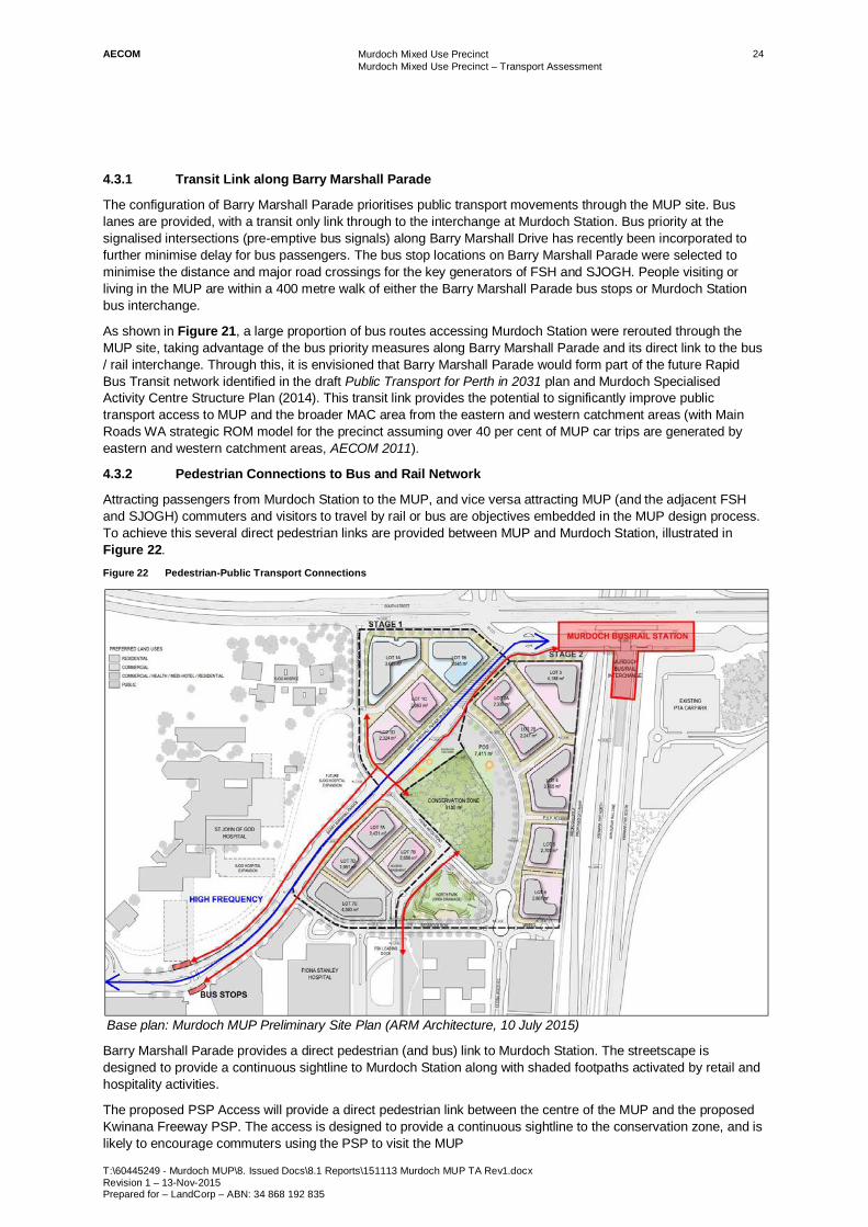
Attracting passengers from Murdoch Station to the MUP, and vice versa attracting MUP (and the adjacent FSH and SJOGH) commuters and visitors to travel by rail or bus are objectives embedded in the MUP design process. To achieve this several direct pedestrian links are provided between MUP and Murdoch Station, illustrated in Figure 22. Figure 22 Pedestrian-Public Transport Connections
Base plan: Murdoch MUP Preliminary Site Plan (ARM Architecture, 10 July 2015)
Barry Marshall Parade provides a direct pedestrian (and bus) link to Murdoch Station. The streetscape is designed to provide a continuous sightline to Murdoch Station along with shaded footpaths activated by retail and hospitality activities.
The proposed PSP Access will provide a direct pedestrian link between the centre of the MUP and the proposed Kwinana Freeway PSP. The access is designed to provide a continuous sightline to the conservation zone, and is likely to encourage commuters using the PSP to visit the MUP

AECOM Murdoch Mixed Use Precinct Murdoch Mixed Use Precinct – Transport Assessment
T:\60445249 - Murdoch MUP\8. Issued Docs\8.1 Reports\151113 Murdoch MUP TA Rev1.docx Revision 1 – 13-Nov-2015 Prepared for – LandCorp – ABN: 34 868 192 835
25
4.4 Public Transport Opportunities 4.4.1 Future Light Rail Transit Link
A proposed LRT system through to Murdoch could replace the east-west Rapid Bus Transit route between Fremantle and Cannington via Murdoch Station currently proposed under the draft Public Transport for Perth in 2031 plan. This would create an attractive, efficient link between Murdoch and other strategic health and tertiary education centres, and greatly improve public transport access to MUP and MAC from eastern and western residential catchments not currently serviced by rail. Such a LRT link would greatly assist with exceeding a 40 per cent mode share for the MAC public transport trips.
Whilst further planning is required to determine the economic feasibility and preferred alignment of a LRT system through the MAC, the transit link along Barry Marshall Parade has been designed to accommodate LRT. The northern section of Barry Marshall Parade (north of Fiona Wood Road) will only provide for transit, cycling and pedestrian movements with a minimum road reservation of 21 metres. This is sufficient to provide LRT, cycle lanes and wide footpaths, as illustrated in Figure 23. If required, additional clearance between the cycle and LRT lanes can be provided by reducing the verge width.
Along the remaining section of Barry Marshall Parade which is shared with other traffic, a minimum road reservation of around 31 metres is provided which can accommodate two light rail tracks, power poles, platform stops and footpaths. The bus lanes on Barry Marshall Parade provide some capacity for a future LRT link, although the reduction of traffic lanes is also necessary to provide continuous transit lanes (to be shared between LRT and buses). The design and impact of a light rail stop along Barry Marshall Parade would have further implications for other road and footpath users, but may not be necessary if a major LRT stop is located adjacent to the Murdoch rail / bus interchange.
The provision of a LRT link through Murdoch Station is constrained by load and space limitations on the existing bus bridge. Strengthening and widening the existing bus bridge, building a new bridge or creating an alternative link on South Street are all options which need further investigation by a joint State Government taskforce. This is outside of the MUP site and it is envisaged that State Government will prepare a concept design for the eventual redevelopment of the Murdoch Station area to accommodate this transit route (bus or light rail) and other necessary capacity changes to the station precinct that are required over the next 20 years. Figure 23 Indicative Light Rail Options for Barry Marshall Parade Transit Link (Emerge Associates, 2012)

AECOM Murdoch Mixed Use Precinct Murdoch Mixed Use Precinct – Transport Assessment
T:\60445249 - Murdoch MUP\8. Issued Docs\8.1 Reports\151113 Murdoch MUP TA Rev1.docx Revision 1 – 13-Nov-2015 Prepared for – LandCorp – ABN: 34 868 192 835
26
4.4.2 Free Transit Zone for MAC
Another recommended initiative is the provision of a Free Transit Zone, to encourage public transport use for shorter trips. The MUP is intended to provide many of the daily activities necessary for the broader MAC commuters and residents, making the centre self-sufficient. Whilst MUP residents, commuters and visitors will be able to walk between different activities the provision of the Free Transit Zone would encourage public transport use for people originating from MAC activities further away from the MUP centre (such as Murdoch University). Within the Perth CBD this has been particularly successful at encouraging more public transport use for business and lunchtime trips. This would not rely on the introduction of a special CAT bus service for MAC, but instead could take advantage of existing bus services rerouted along the MUP transit link. This initiative could be investigated as part of the broader MAC structure planning process.

AECOM Murdoch Mixed Use Precinct Murdoch Mixed Use Precinct – Transport Assessment
T:\60445249 - Murdoch MUP\8. Issued Docs\8.1 Reports\151113 Murdoch MUP TA Rev1.docx Revision 1 – 13-Nov-2015 Prepared for – LandCorp – ABN: 34 868 192 835
27
5.0 Pedestrian and Cycling Movement The vision of the Mixed Use Precinct is to provide a destination precinct that supports, integrates and links with the surrounding health and education uses and injects a range of complimentary business, living and community activities. Through this vision the MUP will support walking and cycling trips for local residents and commuters, as well as visitors to the two adjacent hospitals. The proposed infrastructure and initiatives to encourage people to walk and cycle within and to the MUP are outlined in this section.
5.1 MUP Objectives and Mode Share Targets
The relevant MUP objectives for pedestrian and cycling access are:
- Provide easy and safe access to the bus / rail interchange.
- Provide effective pedestrian linkages through the site.
- Strengthen pedestrian and cycle connectivity to and within the precinct.
The MUP objectives recognise the importance of attractive pedestrian links in achieving the aspirational public transport mode share target. In addition, the objectives highlight the role of the MUP to encourage walking and cycling trips to and from other major MAC activities to access a range of daily activities. The approximate 1,000 residential dwellings will be targeted at MAC employees, students and visitors (up to 82 short-stay rooms), encouraging people to live and work locally to support peak walking and cycling trips. Similar self - sufficient mixed use developments located away from the CBD are relatively untested in Perth, and as such even though there is potential for a significant number of vehicle trips to be avoided, a specific target mode share for walking and cycling has not been specified for the MUP.
5.2 Existing Network A number of previous studies assessed the existing walking and cycling networks surrounding the MUP and broader MAC site (Draft Murdoch Activity Centre Structure Plan B Background Report, Hames Sharley and AECOM 2011; Murdoch Activity Centre – Assessment of Transport Impacts, ARRB 2010; Murdoch Activity Centre Structure Plan A, DPI 2007). Whilst there are reasonably well connected pedestrian networks within the surrounding suburbs, there are a number of access barriers to the MUP (and wider MAC) site. The road width, volume and speed of traffic along the major road corridors bordering the site (Kwinana Freeway, South Street, Murdoch Drive and potentially the extension of Roe Highway) present safety and perceptual barriers. These roads restrict permeability resulting in longer walking and cycling trips, and the dominance of traffic does little to attract non-vehicular traffic along or across these corridors.
For cycling, a shared path is provided along South Street; although this only continues on the northern side of the road west of Murdoch Drive with no direct access between the MUP site and Murdoch University. Dedicated bicycle lanes are provided along Murdoch Drive between South Street and Farrington Road, connecting to shared paths at both ends.
The residential area of Leeming east of Kwinana Freeway, whilst relatively close by, is disconnected from the MAC by the freeway corridor. There is no convenient walking or cycling access from the residential area to the MAC except via South Street and Farrington Road which are over 1.4 kilometres apart. In addition, this area, as well as the other residential areas north of South Street, are characterised by a cul-de-sac road neighbourhood design that reduces connectivity and increases travel distances to nearby places.
A summary of the existing cycling network surrounding the MUP site is illustrated in Figure 24, including the formalised crossings providing access to the MUP.

AECOM Murdoch Mixed Use Precinct Murdoch Mixed Use Precinct – Transport Assessment
T:\60445249 - Murdoch MUP\8. Issued Docs\8.1 Reports\151113 Murdoch MUP TA Rev1.docx Revision 1 – 13-Nov-2015 Prepared for – LandCorp – ABN: 34 868 192 835
28
Figure 24 Existing Cycling Network
Source: Perth Bike Maps, Department of Transport (http://www.transport.wa.gov.au/activetransport/24816.asp)
5.3 Proposed Pedestrian Network The proposed pedestrian network will provide attractive, easy access between MUP, the adjacent hospital and education activities and Murdoch Station. Focusing on these links will greatly improve pedestrian connectivity between major traffic generators within the MAC and promoting it as a transit oriented development. The proposed MUP improvements will not address the pedestrian access barriers across the major South Street and
AECOM Murdoch Mixed Use Precinct Murdoch Mixed Use Precinct – Transport Assessment
T:\60445249 - Murdoch MUP\8. Issued Docs\8.1 Reports\151113 Murdoch MUP TA Rev1.docx Revision 1 – 13-Nov-2015 Prepared for – LandCorp – ABN: 34 868 192 835
29
Kwinana Freeway road corridors, but the MUP will provide new residences within walking distance of the adjacent MAC activities. Improving access to the existing suburbs is to be addressed through MAC and broader government transport initiatives.
5.3.1 Pedestrian Linkages
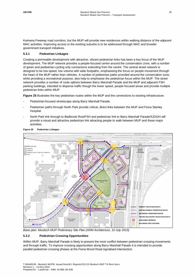
Creating a permeable development with attractive, vibrant pedestrian links has been a key focus of the MUP development. The MUP network provides a people-focused centre around the conservation zone, with a number of green and pedestrian-cycling only connections extending from the centre. The central street network is designed to be low speed, low volume with wide footpaths, emphasising the focus on people movement through the heart of the MUP rather than vehicles. A number of pedestrian paths provided around the conservation zone, while providing a recreational purpose, also help to emphasise the pedestrian focus within the MUP. The street network provides a number of route options between Barry Marshall Parade and the MUP and adjacent FSH parking buildings, intended to disperse traffic though the lower speed, people focused areas and provide multiple pedestrian links within MUP.
Figure 25 illustrates the key pedestrian routes within the MUP and the connections to existing infrastructure:
- Pedestrian-focused streetscape along Barry Marshall Parade.
- Pedestrian paths through North Park provide critical, direct links between the MUP and Fiona Stanley Hospital.
- North Park link through to Bedbrook Row/FSH and pedestrian link to Barry Marshall Parade/SJOGH will provide a visual and attractive pedestrian link attracting people to walk between MUP and these major activities.
Figure 25 Pedestrian Linkages
Base plan: Murdoch MUP Preliminary Site Plan (ARM Architecture, 10 July 2015)
5.3.2 Pedestrian Crossing Opportunities
Within MUP, Barry Marshall Parade is likely to present the most conflict between pedestrian crossing movements and through traffic. To improve crossing opportunities along Barry Marshall Parade it is intended to provide parallel pedestrian crossing phases at the Fiona Wood Road signalised intersection.

AECOM Murdoch Mixed Use Precinct Murdoch Mixed Use Precinct – Transport Assessment
T:\60445249 - Murdoch MUP\8. Issued Docs\8.1 Reports\151113 Murdoch MUP TA Rev1.docx Revision 1 – 13-Nov-2015 Prepared for – LandCorp – ABN: 34 868 192 835
30
With the exception of Fiona Wood Road, the remaining streets within MUP are likely to be characterised by lower volumes of slow moving traffic with a narrow carriageway design. Formal pedestrian crossing facilities are unlikely to be needed along these streets.
5.3.3 Pedestrian Network Opportunities
Creating a self-sufficient centre
A self-sufficient centre is one where residents can live, work and play, being able to access a range of daily activities and needs without travelling outside the centre. The MUP offers an opportunity to achieve this within the broader MAC area. Ensuring that the public realm offers a range of activities will attract users to the MUP from 6am-10pm, every day of the week. Creating after-hours activity will be particularly important, catering for early morning or late evening commuters who need to move through the MUP to access relocated park ‘n’ ride facilities, attracting hospital shift workers to visit during shift breaks or to commute by non-car modes to and from work, and attracting students who could reside in the MUP or visit to socialise and access Murdoch Station. The safety of walking and cycling routes will be strongly influenced by the provision of passive surveillance, as well as the provision of lighting and continuous networks connecting to the broader MAC area and adjacent activities.
Providing a pedestrian bridge from Murdoch Station Park n Ride to MUP and Leeming / Bull Creek
One identified measure to overcome the connectivity barriers is the provision of a new pedestrian and cycle link between the MUP and the Leeming residential area east of the Freeway (SKM 2007, Department of Planning and GHD 2009), as proposed in previous development plans for MUP. As well as increasing walking opportunities to the MUP, this connection could also increase walking and cycling trips for FSH and SJOGH commuters living in these existing eastern suburbs. The cost of this infrastructure is likely to delay implementation until the MUP site is at a later development stage, and this initiative could be considered as part of the PTA Park n Ride relocation and MAC structure planning process.
Improving pedestrian connections across to northern side of South Street and across Murdoch Drive
South Street, as a high speed and high volume traffic route, presents a significant barrier for pedestrians wishing to cross between the MUP and the residential catchment north of the road. As the MUP is envisaged to be a key destination for residents in Murdoch and the surrounding area, it is essential that sufficient safe and efficient pedestrian connections be established. The MAC strategy indicates that shared paths will be provided across Murdoch Drive connecting Murdoch University to SJOG Hospital and through to the MUP.
5.4 Proposed Cycling Network The broader MAC strategy proposes that along high volume traffic roads, cycle routes be provided via shared paths separated from the road carriageway. Along transit routes, the road design should ensure the safe integration of the cycle network along the corridor. In other areas, where the focus is on pedestrian and cyclist movement over vehicle movement, on-road cycle lanes are proposed, which will help to lower traffic volumes and speeds, and create a safer environment for non-motorised road users. The proposed cycle facilities within MUP are integrated with existing and proposed cycle routes extending through the MAC and surrounding suburbs.
5.4.1 Cycling Linkages
On-road cycles lanes along Barry Marshall Parade and Bedbrook Row and a dedicated cycle only path to the PSP provide direct links to key external routes. Within the centre of the MUP, pedestrian movement becomes the focus, and as such, only informal pedestrian and cycle space is provided along Road 1.
The cycle routes are illustrated in Figure 26. This includes:
- Existing dedicated cycle lanes along Fiona Wood Road and on Barry Marshall Parade north of Fiona Wood Road, shared cycle/bus lanes on Barry Marshall Parade south of Fiona Wood Road and on Bedbrook Row– providing a link between the western MAC activities (Murdoch University, FSH) and MUP.
- PSP connection between Site 4 & 5: cycle only path providing a direct link into MUP from the north-south regional bike route.

AECOM Murdoch Mixed Use Precinct Murdoch Mixed Use Precinct – Transport Assessment
T:\60445249 - Murdoch MUP\8. Issued Docs\8.1 Reports\151113 Murdoch MUP TA Rev1.docx Revision 1 – 13-Nov-2015 Prepared for – LandCorp – ABN: 34 868 192 835
31
Figure 26 Cycling Linkages
Base plan: Murdoch MUP Preliminary Site Plan (ARM Architecture, 10 July 2015)
The proposed MUP cycle network connects to the broader MAC cycle network strategy, illustrated in Figure 27. The on-road cycle lanes along Barry Marshall Parade link the MUP directly to Murdoch University campus. A cycle path is also proposed to link the MUP to the PSP that runs along Kwinana Freeway. Figure 27 MAC Bicycle Route Hierarchy (Department of Planning, 2014)

AECOM Murdoch Mixed Use Precinct Murdoch Mixed Use Precinct – Transport Assessment
T:\60445249 - Murdoch MUP\8. Issued Docs\8.1 Reports\151113 Murdoch MUP TA Rev1.docx Revision 1 – 13-Nov-2015 Prepared for – LandCorp – ABN: 34 868 192 835
32
5.4.2 Cycle Parking
To further encourage cycling with the MAC area, end of trip facilities including secure, sheltered bike racks and shower facilities are to be provided in all commercial buildings. On-street public bike racks are also to be provided at regular intervals within the MUP. In particular, a bicycle hub is proposed to be located within the transit zone along Barry Marshall Parade. This will include lockable and open bike storage in a shared area adjacent to the on-road cycle paths.
5.4.3 Cycle Network Opportunities
Bike hire scheme linking local activities
The introduction of a bike hire scheme has been considered as part of the MAC structure planning process. This would help to encourage the use of bicycles for local trips such as between the MUP, Murdoch Station, Murdoch University, the hospitals and other activities, and will help to further promote active transport modes and reduce the number of vehicles in the area. Further investigation into implementing such a scheme in order for it to be successful is still required.

AECOM Murdoch Mixed Use Precinct Murdoch Mixed Use Precinct – Transport Assessment
T:\60445249 - Murdoch MUP\8. Issued Docs\8.1 Reports\151113 Murdoch MUP TA Rev1.docx Revision 1 – 13-Nov-2015 Prepared for – LandCorp – ABN: 34 868 192 835
33
6.0 Traffic Assessment
6.1 MAC Traffic Modelling Background AECOM was engaged by Department of Transport to develop a Commuter microsimulation model for the MAC.
The 2031 model includes the entire MAC Structure Plan Area and future planned surrounding road upgrades such as the extension of Roe Highway and associated southern connection (South Metro Connect design) as well as the southern extension of Fiona Wood Road to Farrington Road. The model extent and road network are shown in Figure 28.
This model was subsequently refined to undertake the detailed traffic analysis for MUP. Figure 28 Commuter Model Network
AECOM Murdoch Mixed Use Precinct Murdoch Mixed Use Precinct – Transport Assessment
T:\60445249 - Murdoch MUP\8. Issued Docs\8.1 Reports\151113 Murdoch MUP TA Rev1.docx Revision 1 – 13-Nov-2015 Prepared for – LandCorp – ABN: 34 868 192 835
34
6.2 Traffic Demands 6.2.1 General Approach for MAC
The 2031 peak period traffic demands (cordon matrices) were obtained from the Department of Transport’s STEM Cube model, using the latest MAC modelling scenarios. A base year calibration was undertaken on the critical cordon links and the demands were adjusted accordingly to account for the differences between the modelled and observed counts, assuming these differences would be carried over to the future cases.
For other background traffic generated by the other land uses within MAC, two parking charge sensitivity scenarios were tested in the MAC modelling exercise:
- Scenario 1: No parking charge; and
- Scenario 2: $15/day parking charge
As expected, the traffic demands yielded in Scenario 2 were lower than those yielded in Scenario 1. Thus the overall traffic demands from Scenario 1 were used for this assessment, with the exception of the Murdoch University Eastern Precinct, discussed below.
6.2.2 Murdoch University including Eastern Precinct
The traffic generation for the core Murdoch University was based on the calibration adjusted 2031 STEM model Scenario 1, which has similar magnitude as the observed existing traffic generation. For the Eastern Precinct, the 2031 Scenario 2 forecast was used to provide a more realistic level of traffic generation compared to the proposed parking provision.
6.2.3 Fiona Stanley Hospital and St John of God Hospital
Traffic generation for Fiona Stanley Hospital and St John of God Hospital used in this assessment was taken from previous nano-simulation modelling work undertaken by Urbsol, as this nano model is the most detailed modelling undertaken for this site.
This model was originally developed for Department of Health and has accounted for not only detailed land uses and car park locations, but also detailed operations of both hospitals, such as the shift times for doctors and nurses, and arrival and departure profiles for visitors.
It is noted that the trip generation numbers from Urbsol model used in this study may overestimate some car trips, specifically due to the following points:
- The model does not account for the internalisation of trips within the site – i.e. all generated trips are assumed to originate or terminate from the wider network, which is contrary to the objectives and design of MUP.
- All car trips were assumed to be single occupancy – in reality a number of users may car share which may reduce overall car trip activity.
- For St John of God Hospital, the assumed trip generation includes a 40 percent increase in traffic levels prior to the expansion (based on the proposed 40 percent increase in bed capacity, rather than the smaller increase in car parking spaces).
6.2.4 Murdoch Station Park n Ride
Traffic generation for the Murdoch Station Park n Ride (both eastern and western) was derived from direct observation of existing volumes and movements, as information on how these car parks may change were simply not available.
6.2.5 MUP
The traffic impact assessment is based upon the full build out and occupancy of Stage 1 only. Stage 2 was not modelled due to the uncertainty surrounding the potential relocation of the Murdoch Station western Park n Ride facility, which sits within the Stage 2 development area. Thus the scenario modelled assumes the Park n Ride facility is retained within the MUP Stage 2 site during Stage 1.
Traffic generation assumptions from previous modelling undertaken for MUP by Urbsol have been adopted in this study. However, it is noted that in this study, only vehicle trip components were considered and additional people trips were not modelled.

AECOM Murdoch Mixed Use Precinct Murdoch Mixed Use Precinct – Transport Assessment
T:\60445249 - Murdoch MUP\8. Issued Docs\8.1 Reports\151113 Murdoch MUP TA Rev1.docx Revision 1 – 13-Nov-2015 Prepared for – LandCorp – ABN: 34 868 192 835
35
Traffic generation for stage 1 was split into two zones – Site 1 (comprising lots 1A, 1B 1C and 1D) and Site 7 (comprising lots 7A, 7B and 7C+7D). The proposed land uses are summarised in Table 1. Table 1 Stage 1 Land Use Yields
Site Retail Supermarket Residential Commercial Commercial
Health Short-Stay Parking Bays GFA
(m2) GFA (m2) No. of Apartments GFA (m2) GFA (m2) No. of
Apartments
Site 1 1,150 - 167 33,120 - - 720
Site 7 950 2,800 286 - 8,240 82 613
Trip generation for each land use type was determined as follows:
- Retail – based on the maximum number of car parking bays that could be provided as per parking policy and trip movement data at a typical retail / commercial car park.
- Supermarket – based on the gross floor area and rates from the Institute of Transport Engineers (ITE) handbook
- Residential – based on the number of apartment dwellings and vehicle trip generation from residential properties within transit oriented developments (TOD) published by Cervero and Arrington
- Commercial – based on the maximum number of car parking bays that could be provided as per parking policy and assumptions on the occupancy of these during peak periods for employees and visitors
- Commercial Health – same as per commercial
- Short-Stay – based on the number of rooms and rates from the ITE handbook.
The total number of trips assumed to be generated by the MUP Stage 1 development is summarised in Table 2. Table 2 Stage 1 Trip Generation
Peak Period (2 hour) Inbound Trips Outbound Trips
Site 1 Total
AM 474 75
PM 76 519
Site 7 Total
AM 331 242
PM 500 546
More details on the peak hour traffic generation assumptions are provided Appendix A.
It is noted that these assumptions do not account for the ‘internalisation’ of trips for the MUP site, whereby a number of trips to / from the proposed retail facilities and workplaces will originate from MUP or adjacent sites. This would reduce the number of car and public transport trips generated by the model. The subsequent increase in pedestrian trips would not necessarily affect the MUP signalised intersections, as there are alternative pedestrian routes through the site.
6.2.6 Traffic Generation Summary
A summary of the traffic generation of each MAC precinct is provided in Table 3. The data showed that the MUP constitutes approximately 10% of the traffic generated by the MAC area.

AECOM Murdoch Mixed Use Precinct Murdoch Mixed Use Precinct – Transport Assessment
T:\60445249 - Murdoch MUP\8. Issued Docs\8.1 Reports\151113 Murdoch MUP TA Rev1.docx Revision 1 – 13-Nov-2015 Prepared for – LandCorp – ABN: 34 868 192 835
36
Table 3 MAC Traffic Generation Summary
Precinct AM(7:00-9:00) PM(16:00-18:00)
Outbound Inbound Total Composition Outbound Inbound Total Composition
Murdoch University 515 2523 3038 22% 1674 819 2492 18%
MU Eastern Precinct 560 3257 3817 28% 3699 1100 4799 34%
Kennedy Baptist College 196 463 659 5% 284 130 414 3%
MUP 323 815 1138 8% 1068 579 1647 12%
SJOG 306 917 1223 9% 862 588 1450 10% Fiona Stanley
Hospital 933 2520 3452 25% 2127 956 3083 22% Training and Tech Precinct 37 291 328 2% 241 60 300 2%
Total 2869 10787 13656 100% 9955 4230 14185 100%
6.3 Traffic Analysis 6.3.1 Intersection Level of Service
Table 4 summarises the levels of service (LoS) at key intersections in the vicinity of and within the MUP site. Average delay, maximum queues (number of queuing vehicles in all lanes) and LoS are provided.
The results showed significant westbound traffic delay and queueing at South Street / Kwinana Freeway interchange in the AM peak. Since these three intersections are closely spaced, the model results only reflect the delay and queuing on the short links between the intersections. The critical capacity constraint occurs at the northbound interchange, but the queues impact both upstream ramp intersections and beyond towards the east.
Congestion is also expected at the Murdoch Drive / South Street intersection in both peaks. Other intersections in the MUP vicinity are expected to operate satisfactorily. Table 4 Intersection LoS
Intersection Approach
AM Peak PM Peak Ave
Delay (s)
Max Queue (veh)
LoS Ave
Delay (s)
Max Queue (veh)
LoS
South Street / Kwinana Fwy Southbound On Ramp
South St EB 28 30 B 31 28 C
Bus Station EB 94 2 F 94 63 F
Eastern Car Park NB 81 14 F 69 29 E
South St WB 370 426 F 31 96 C
All 230 118 F 34 54 C
South Street / Kwinana Fwy Southbound Off Ramp
South St EB 15 18 B 4 10 A
South St WB 71 67 F 9 10 A
Kwinana SB Off-ramp 83 52 F 94 25 F
All 56 46 D 15 15 B
South Street / Kwinana Fwy Northbound Ramps
South St WB 57 85 E 38 45 C
Bus Station WB 78 2 F 90 1 F
South St EB 73 61 F 31 48 C
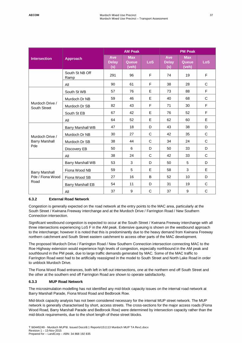
AECOM Murdoch Mixed Use Precinct Murdoch Mixed Use Precinct – Transport Assessment
T:\60445249 - Murdoch MUP\8. Issued Docs\8.1 Reports\151113 Murdoch MUP TA Rev1.docx Revision 1 – 13-Nov-2015 Prepared for – LandCorp – ABN: 34 868 192 835
37
Intersection Approach
AM Peak PM Peak Ave
Delay (s)
Max Queue (veh)
LoS Ave
Delay (s)
Max Queue (veh)
LoS
South St NB Off Ramp 291 96 F 74 19 F
All 90 61 F 38 28 C
Murdoch Drive / South Street
South St WB 57 76 E 73 88 F
Murdoch Dr NB 59 46 E 40 68 C
Murdoch Dr SB 82 43 F 71 30 F
South St EB 67 42 E 76 52 F
All 64 52 E 62 60 E
Murdoch Drive / Barry Marshall Pde
Barry Marshall WB 47 18 D 43 38 D
Murdoch Dr NB 30 27 C 42 35 C
Murdoch Dr SB 38 44 C 34 24 C
Discovery EB 50 6 D 50 33 D
All 38 24 C 42 33 C
Barry Marshall Pde / Fiona Wood Road
Barry Marshall WB 53 3 D 50 5 D
Fiona Wood NB 59 5 E 58 3 E
Fiona Wood SB 27 16 B 52 10 D
Barry Marshall EB 54 11 D 31 19 C
All 37 9 C 37 9 C
6.3.2 External Road Network
Congestion is generally expected on the road network at the entry points to the MAC area, particularly at the South Street / Kwinana Freeway interchange and at the Murdoch Drive / Farrington Road / New Southern Connection intersection.
Significant westbound congestion is expected to occur at the South Street / Kwinana Freeway interchange with all three intersections experiencing LoS F in the AM peak. Extensive queuing is shown on the westbound approach to the interchange; however it is noted that this is predominantly due to the heavy demand from Kwinana Freeway northern catchment and South Street eastern catchment to access other parts of the MAC development.
The proposed Murdoch Drive / Farrington Road / New Southern Connection intersection connecting MAC to the Roe Highway extension would experience high levels of congestion, especially northbound in the AM peak and southbound in the PM peak, due to large traffic demands generated by MAC. Some of the MAC traffic to Farrington Road west had to be artificially reassigned in the model to South Street and North Lake Road in order to unblock Murdoch Drive.
The Fiona Wood Road entrances, both left in left out intersections, one at the northern end off South Street and the other at the southern end off Farrington Road are shown to operate satisfactorily.
6.3.3 MUP Road Network
The microsimulation modelling has not identified any mid-block capacity issues on the internal road network at Barry Marshall Parade, Fiona Wood Road and Bedbrook Row.
Mid-block capacity analysis has not been considered necessary for the internal MUP street network. The MUP network is generally characterised by short, access streets. The cross-sections for the major access roads (Fiona Wood Road, Barry Marshall Parade and Bedbrook Row) were determined by intersection capacity rather than the mid-block requirements, due to the short length of these street blocks.

AECOM Murdoch Mixed Use Precinct Murdoch Mixed Use Precinct – Transport Assessment
T:\60445249 - Murdoch MUP\8. Issued Docs\8.1 Reports\151113 Murdoch MUP TA Rev1.docx Revision 1 – 13-Nov-2015 Prepared for – LandCorp – ABN: 34 868 192 835
38
All the other MUP streets cater for local access to on-street and off-street parking facilities. The local access streets include a single lane in each direction, and are designed for low traffic and slow speed conditions.
6.3.4 Pedestrian Crossings at Barry Marshall Parade / Fiona Wood Road
The Barry Marshall Parade / Fiona Wood Road intersection is expected to operate at an acceptable LoS of C in the peak periods.
Pedestrian crossings along Barry Marshall Drive were modelled as 12-second fully protected parallel pedestrian crossings (vehicles are not permitted to turn across the pedestrian crossing when the pedestrian signal is green or flashing red).
Given the forecast mode share for the MUP and overall MAC area, there is likely to be a large number of pedestrian movements at the intersection, and as such a fully protected pedestrian crossing was considered preferable. There may be a desire to increase the amount of full protected pedestrian crossing time, should pedestrian volumes warrant it. This would result in reduced green time for vehicle movements. However, there is expected to be sufficient capacity at the intersection to accommodate additional pedestrian crossing time should this be required, without significantly impacting on the LoS for vehicle movements.
6.4 Conclusions The traffic impact assessment has identified a number of issues with the operation of the external road network, particularly at the South Street / Kwinana Freeway interchange and the Murdoch Drive / Farrington Road / New Southern Connection intersection.
It is noted that the MUP development is not considered to be the primary cause of the predicted peak period congestion on the external road network. The MUP parking strategy and objectives to achieve a 40 percent public transport mode share for employees and create a self-sufficient centre all contribute to reducing peak period traffic generated by the MUP development. Vehicle trips generated by the MUP Stage 1 development account for only 10 percent of all vehicle trips into the MAC area.
A significant proportion of the high traffic demands are instead attributed to the wider MAC area. Addressing the predicted traffic demand and corresponding peak period delay at the South Street / Kwinana Freeway interchange should therefore be addressed by the broader MAC transport strategy.
The MUP internal intersections are all predicted to operate satisfactorily.
6.5 Limitations of Modelling It is noted that traffic modelling has its limitations. Traffic demands were taken from high level strategic models and as such there is always some level of uncertainty. The results presented in this study should therefore only be viewed as an indication of what may occur in the future.
AECOM Murdoch Mixed Use Precinct Murdoch Mixed Use Precinct – Transport Assessment
T:\60445249 - Murdoch MUP\8. Issued Docs\8.1 Reports\151113 Murdoch MUP TA Rev1.docx Revision 1 – 13-Nov-2015 Prepared for – LandCorp – ABN: 34 868 192 835
39
7.0 References AECOM (2011) MUP Access Study
AECOM (2013) MUP Transport Assessment
AECOM (2015) MUP Parking Strategy
Cervero and Arrington (2008) Vehicle Trip Reduction Impacts of Transit-Oriented Housing
Department of Planning and Department of Health (2007) Murdoch Activity Centre Structure Plan: Part A – Fiona Stanley Hospital and Health Precinct.
Department of Planning & GHD (2009) Murdoch Mixed Use Precinct Business Case
Department of Transport (2011) Draft Public Transport for Perth in 2031
LandCorp (2012) Business Case – Murdoch Mixed Use Precinct
Lund, Cervero & Willson (2005), Travel Characteristics of Transit Orientated Development in California
Martinovich (2011) Struggles in finding an optimum transit solution for metropolitan Perth Presentation - 2011 SMART Urban Transport Conference
Parker and Arrington (2002) Statewide Transit-Oriented Development Study: Factors for Success in California
Public Transport Authority (2011) Murdoch Station Park n Ride Residential Origin Survey SKM (2006) Southern Tertiary Health Precinct Transport Plan Report ()
SKM (2008) Southern Tertiary Health Precinct Transport Model Update
Urbsol (2012a) Traffic Modelling and Analysis Report Fiona Stanley Hospital Landcorp Development - Final Report
Urbsol (2012b) Traffic Modelling and Analysis Report for LandCorp MUP Development Design Options 4B and 5 Comparison Report
Urbsol (2012c) Traffic Modelling and Analysis Report for LandCorp MUP Development Update DRAFT Report
Urbsol (2013) Traffic Modelling and Analysis Report for LandCorp Mixed Use Precinct Update DRAFT Report
WAPC (2006a) Development Control Policy (DCP) 1.6 Planning to Support Transit Use and Transit Orientated Development
WAPC (2006b) Transport Assessment Guidelines for Developments, Volume 2 – Structure Plans ()
WAPC (2010a) Directions 2031 and Beyond
WAPC (2010b) State Planning Policy (SPP) 4.2 – Activity Centres for Perth and Peel
WAPC (2011) Murdoch Activity Centre Access and Parking Policy
WAPC & Department of Planning (2014) Murdoch Specialised Activity Centre Structure Plan
Worley Parsons (2010) Murdoch Activity Centre Public Transport Master Plan

AECOM Murdoch Mixed Use Precinct Murdoch Mixed Use Precinct – Transport Assessment
T:\60445249 - Murdoch MUP\8. Issued Docs\8.1 Reports\151113 Murdoch MUP TA Rev1.docx Revision 1 – 13-Nov-2015 Prepared for – LandCorp – ABN: 34 868 192 835
Appendix A
Traffic Generation Assumptions

Murdoch Mixed Use Precinct Appendix A - Traffic Generation Assumptions
Revision 1 – 13-Nov-2015 Prepared for – LandCorp – ABN: 34 868 192 835
1
Appendix A Traffic Generation Assumptions
1.1 Site 1 Site 1 comprises of 4 lots which have a mix of retail, residential and commercial uses, as summarised in Table 1. Table 1 Site 1 Yield
Lot Retail Residential Commercial
Parking Bays GFA (m2) No. of Apartments GFA (m2) NLA (m2)
1A 0 0 17,150 13,720 270
1B 550 0 15,970 12,776 229
1C 600 82 0 0 111
1D 0 85 0 0 110
Site 1 1,150 167 33,120 26,496 720
1.1.1 Retail
Site 1 includes a total of 1,150 m2 of GFA for retail use, for which 23 car parking bays are assumed to be provided (maximum provision as per parking policy).
The Urbsol modelling assumptions for commercial and retail trip generation were based on observed behaviour of car parking facilities that serve mixed commercial / retail purposes such as these. Obtaining information on car park operating dynamics for retail and commercial users was difficult as there are few locations in Perth likely to operate similar to the car parks for the commercial precincts. Data was obtained from a professional car park survey company called Parking Consultants international (PCI) who operate out of Sydney. PCI provided an arrival and departure profile for a typical car park in Chatswood, New South Wales.
While not identical it had a number of features that were likely to be similar to the MUP development:
- Has an 'attached' commercial tower and surrounding commercial offices
- 199 spaces
- Offers early bird, monthly and hourly casual parking
- The survey showed approximately 76% of parkers are monthly, 20% early bird, 4% casual
Figure 1 summarises occupancy through the day for the facility, with further analysis of this data provided in Table 2.

Murdoch Mixed Use Precinct Appendix A - Traffic Generation Assumptions
Revision 1 – 13-Nov-2015 Prepared for – LandCorp – ABN: 34 868 192 835
2
Figure 1 Observed Car Park Occupancy
Table 2 Summary of Car Park Data
Time Inbound Outbound
Bays Occ in period Tot Bays Occ Rate Bays Occ in
period Tot Bays Occ Rate
06:45 - 07:45 38 199 19.10% 1 199 0.50%
07:45 - 08:45 77 199 38.69% 1 199 0.50%
15:30 - 16:30 5 199 2.51% 24 199 12.06%
16:30 - 17:30 1 199 0.50% 56 199 28.14%
The observed arrival and departure rates of the car park (as a function of the total number of bays) forms the basis for trip generation for large retail land use for the MUP development. The resulting peak period trip assumptions are provided below in Table 3. Table 3 Site 1 – Retail Traffic Generation
Peak Period Inbound Trips Outbound Trips
Site 1 Retail – 23 car bays
AM1 4 0
AM2 9 0
PM1 1 3
PM2 0 6
1.1.2 Residential
Site 1 includes a total of 167 residential apartment dwellings.
Urbsol developed traffic generation rates by examining research undertaken in the US relating to Transit Oriented Development. The research by Cervero and Arrington (Cervero and Arrington, 2008) compared the vehicle trip generation from residential properties within TODs and those published by the Institute of Transport Engineers (ITE), shown in Figure 2.
0
20
40
60
80
100
120
140
160
180
Num
ber
of c
ars
Time
Car Park Occupancy

Murdoch Mixed Use Precinct Appendix A - Traffic Generation Assumptions
Revision 1 – 13-Nov-2015 Prepared for – LandCorp – ABN: 34 868 192 835
3
- They surveyed 17 housing project sites that ranged in size from 90 unit complexes through to 854 and as such represent a reasonable sample size.
- The average number of parking spaces per project was around 400, yielding an average rate of 1.16 spaces per dwelling unit.
- Six of the surveyed housing projects had ground-floor retail and/or commercial uses; however, all were primarily residential in nature (i.e., over 90% of gross floor area was for residential activities).
Figure 2 Comparison of TOD and ITE Trip Generation Rates (Source Cervero and Arrington 2008)
Given the similarity in bay provision per dwelling to the study, the above rates are adopted for each hour of the model as shown in Table 4. Table 4 Site 1 – Residential Vehicle Trip Generation
Vehicle Trips Generation Rates (Per Dwelling) Inbound Outbound Generation Inbound Outbound
Site 1 Residential – 167 dwellings
AM Peak Hours 0.279 20% 80% 46 9 37
PM Peak Hours 0.345 65% 35% 57 37 20
1.1.3 Commercial
Site 1 includes a total of 33,120 m2 of GFA for commercial space, for which 552 car bays (414 employee bays and 138 visitor bays) are assumed to be provided (maximum provision as per parking policy).
For visitor bays, the model assumed 10 percent activity in the AM peak hours (all inbound) and 20 percent activity in the PM peak hour (all outbound).
For staff parking, given the scarcity in provision compared to likely employee levels, it was assumed that all bays are consumed during the model peak periods. The rate of occupation was assumed to follow the parking arrival and departure rates observed from the parking survey illustrated in Figure 1 and Table 2 for the retail trip generation assumptions.
All trips in the morning are assumed inbound and all staff trips in the PM peak are assumed outbound.
A summary of the resulting peak period trip assumptions is provided in Table 5 and Table 6.

Murdoch Mixed Use Precinct Appendix A - Traffic Generation Assumptions
Revision 1 – 13-Nov-2015 Prepared for – LandCorp – ABN: 34 868 192 835
4
Table 5 Site 1 – Commercial Traffic Generation – AM Peak Hours (All Inbound)
Period Time Utilisation AM1 vs AM2 Employee Visitor Total 15 min rates
Site 1 Commercial – 414 employee car bays, 138 visitor car bays
AM1
06:45 - 07:00 5.22%
33.04% 137 14 145
15.79%
07:00 - 07:15 5.22% 15.79%
07:15 - 07:30 10.43% 31.58%
07:30 - 07:45 12.17% 36.84%
AM2
07:45 - 08:00 20.87%
66.96% 277 14 286
31.17%
08:00 - 08:15 19.13% 28.57%
08:15 - 08:30 12.17% 18.18%
08:30 - 08:45 14.78% 22.08%
Table 6 Site 1 – Commercial Traffic Generation – PM Peak Hours (All Outbound)
Period Time Utilisation PM1 vs PM2 Employee Visitor Total 15 min rates
Site 1 Commercial – 414 employee car bays, 138 visitor car bays
PM1
15:30 -15:45 3.75%
30.00% 124 28 141
12.50%
15:45 - 16:00 8.75% 29.17%
16:00 - 16:15 5.00% 16.67%
16:15 - 16:30 12.50% 41.67%
PM2
16:30 -16:45 8.75%
70.00% 290 28 306
12.50%
16:45 - 17:00 32.50% 46.43%
17:00 - 17:15 17.50% 25.00%
17:15 - 17:30 11.25% 16.07%
1.1.4 Total
The total traffic generation for Site 1 is summarised in Table 7. Table 7 Site 1 – Total Traffic Generation
Peak Period Inbound Trips Outbound Trips
Site 1 Total
AM1 164 37
AM2 309 37
PM1 38 175
PM2 38 344

Murdoch Mixed Use Precinct Appendix A - Traffic Generation Assumptions
Revision 1 – 13-Nov-2015 Prepared for – LandCorp – ABN: 34 868 192 835
5
1.2 Site 7 Site 7 comprises of 4 lots which have a mix of retail, supermarket, residential, commercial/health and short-stay (hotel) uses, as summarised in Table 8. Table 8 Site 7 Yield
Lot Retail Supermarket Residential Commercial Health Short-Stay Parking
Bays GFA (m2) GFA (m2) No. of
Apartments GFA (m2) NLA (m2) No. of Apartments
7A 0 0 118 0 0 0 148
7B 0 0 117 0 0 0 142
7C + 7D 950 2,800 51 8,240 6,592 82 323
Site 7 950 2,800 286 8,240 6,592 82 613
1.2.1 Retail
Site 7 includes a total of 950 m2 of GFA for retail use, for which 19 car parking bays are assumed to be provided (maximum provision as per parking policy).
The same traffic generation rates as detailed for retail use in Site 1 are applied, with resulting peak period trip assumptions are provided below in Table 9. Table 9 Site 7 – Retail Traffic Generation
Peak Period Inbound Trips Outbound Trips
Site 7 Retail – 19 car bays
AM1 4 0
AM2 7 0
PM1 0 2
PM2 0 5
1.2.2 Supermarket
Site 7 includes 2,800 m2 of GFA for a supermarket.
Generation for this component of the site is based on the ITE handbook (Supermarket 850) which produces trip generation assumptions shown in Table 10. Table 10 Site 7 – Supermarket Traffic Generation
Vehicle Trips ITE Supermarket 850 Generation Rates (per 1000 square feet)
Inbound Outbound Generation Inbound Outbound
Site 7 Supermarket – 2,800 m2 = 30, 139 ft2 GFA
AM Peak Hours 3.59 61% 39% 108 66 42
PM Peak Hours 10.50 51% 49% 316 161 155
It is also noted that the above trip assumptions are for the AM2 and PM2 peak hours. Trip generation for the AM1 peak hour is assumed to be 85 percent of the AM2 peak hour and trip generation for the PM1 peak hour is assumed to be 98% of the PM2 peak hour.

Murdoch Mixed Use Precinct Appendix A - Traffic Generation Assumptions
Revision 1 – 13-Nov-2015 Prepared for – LandCorp – ABN: 34 868 192 835
6
1.2.3 Residential
Site 7 includes a total of 286 residential apartment dwellings.
The same traffic generation rates as detailed for residential use in Site 1 are applied, with resulting peak period trip assumptions provided below in Table 11. Table 11 Site 7 – Residential Vehicle and Additional Person Trip Generation
Vehicle Trips Generation Rates (Per Dwelling) Inbound Outbound Generation Inbound Outbound
Site 7 Residential – 286 dwellings
AM Peak Hours 0.279 20% 80% 80 16 64
PM Peak Hours 0.345 65% 35% 99 64 35
1.2.4 Commercial Health
Site 7 includes a total of 8,240 m2 of GFA for commercial health use, for which 137 car bays (103 employee bays and 34 public / visitor bays) are assumed to be provided (maximum provision as per parking policy)
The same traffic generation rates as detailed for commercial use in Site 1 are applied, with resulting peak period trip assumptions as provided below in Table 12 and Table 13. Table 12 Site 7 – Commercial Traffic Generation – AM Peak Hours (All Inbound)
Period Time Utilisation AM1 vs AM2 Employee Visitor Total 15 min rates
Site 7 Commercial – 103 employee car bays, 34 visitor car bays
AM1
06:45 - 07:00 5.22%
33.04% 34 3 36
15.79%
07:00 - 07:15 5.22% 15.79%
07:15 - 07:30 10.43% 31.58%
07:30 - 07:45 12.17% 36.84%
AM2
07:45 - 08:00 20.87%
66.96% 69 3 71
31.17%
08:00 - 08:15 19.13% 28.57%
08:15 - 08:30 12.17% 18.18%
08:30 - 08:45 14.78% 22.08%
Table 13 Site 1 – Commercial Traffic Generation – PM Peak Hours (All Outbound)
Period Time Utilisation PM1 vs PM2 Employee Visitor Total 15 min rates
Site 7 Commercial – 103 employee car bays, 34 visitor car bays
PM1
15:30 -15:45 3.75%
30.00% 31 7 36
12.50%
15:45 - 16:00 8.75% 29.17%
16:00 - 16:15 5.00% 16.67%
16:15 - 16:30 12.50% 41.67%
PM2
16:30 -16:45 8.75%
70.00% 72 7 77
12.50%
16:45 - 17:00 32.50% 46.43%
17:00 - 17:15 17.50% 25.00%
17:15 - 17:30 11.25% 16.07%

Murdoch Mixed Use Precinct Appendix A - Traffic Generation Assumptions
Revision 1 – 13-Nov-2015 Prepared for – LandCorp – ABN: 34 868 192 835
7
1.2.5 Short-stay (Hotel)
The hotel will comprise 82 rooms.
The Urbsol model based the hotel trip generation on the ITE handbook (Hotel 310). It was assumed all Hotel trips are vehicle trips. The results are summarised below in Table 14. Table 14 Site 7 Hotel Trip Generation
Vehicle Trips ITE Hotel 310 Generation Rates (Per Room)
Inbound Outbound Generation Inbound Outbound
Site 7 Hotel – 82 rooms
AM Peak Hours 0.56 61% 39% 46 28 18
PM Peak Hours 0.59 53% 47% 49 26 23
1.2.6 Total
The total traffic generation for Site 7 is summarised in Table 15. Table 15 Site 7 – Total Traffic Generation
Peak Period Inbound Trips Outbound Trips
Site 7 Total
AM1 141 118
AM2 190 124
PM1 248 249
PM2 251 297