REPORT ROADSIDE AND OUTFALL DRAINAGE DITCHES Report Exhibits... · · 2017-03-29REPORT . ROADSIDE...
38
MIDDLE PENINSULA PLANNING DISTRICT COMMISSION REPORT ROADSIDE AND OUTFALL DRAINAGE DITCHES John S. Morris, III Beale, Davidson, Etherington & Morris, P.C. Richmond, Virginia September 3, 2013
-
Upload
duongthuan -
Category
Documents
-
view
222 -
download
2
Transcript of REPORT ROADSIDE AND OUTFALL DRAINAGE DITCHES Report Exhibits... · · 2017-03-29REPORT . ROADSIDE...

MIDDLE PENINSULA PLANNING DISTRICT COMMISSION
REPORT
ROADSIDE AND OUTFALL DRAINAGE DITCHES
John S. Morris, III Beale, Davidson, Etherington & Morris, P.C.
Richmond, Virginia September 3, 2013
ii
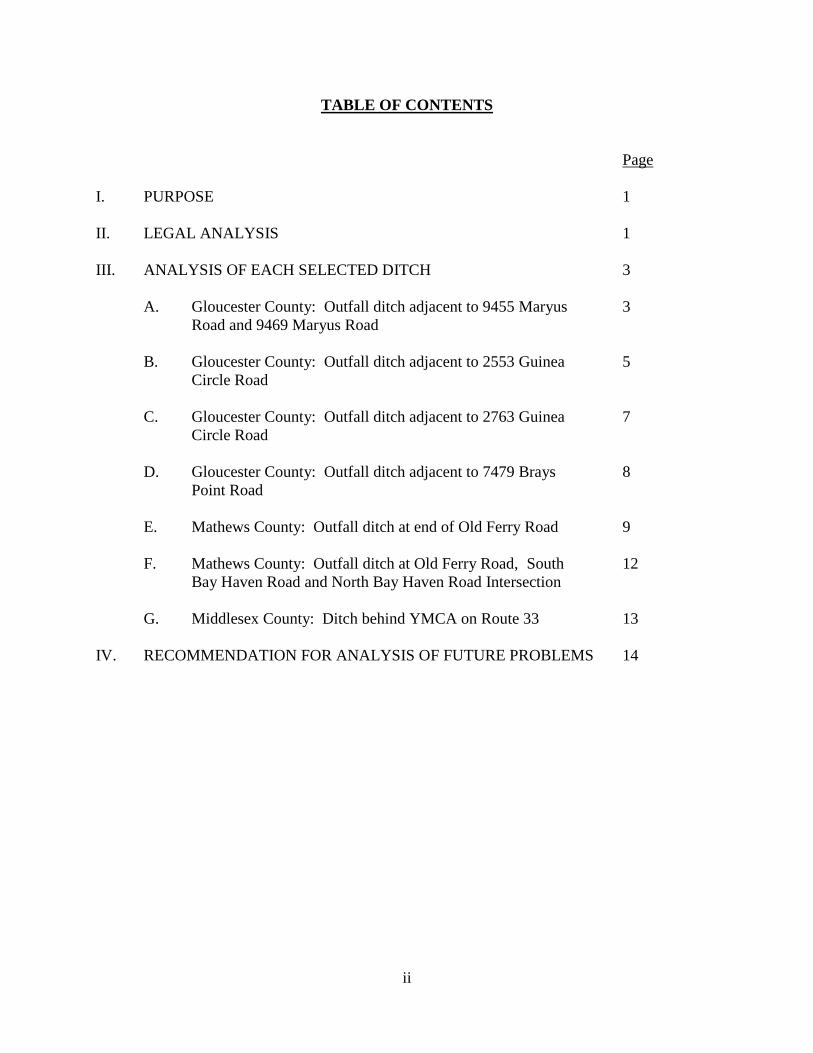
TABLE OF CONTENTS
Page I. PURPOSE 1 II. LEGAL ANALYSIS 1 III. ANALYSIS OF EACH SELECTED DITCH 3 A. Gloucester County: Outfall ditch adjacent to 9455 Maryus 3 Road and 9469 Maryus Road B. Gloucester County: Outfall ditch adjacent to 2553 Guinea 5 Circle Road C. Gloucester County: Outfall ditch adjacent to 2763 Guinea 7 Circle Road D. Gloucester County: Outfall ditch adjacent to 7479 Brays 8 Point Road E. Mathews County: Outfall ditch at end of Old Ferry Road 9 F. Mathews County: Outfall ditch at Old Ferry Road, South 12 Bay Haven Road and North Bay Haven Road Intersection G. Middlesex County: Ditch behind YMCA on Route 33 13 IV. RECOMMENDATION FOR ANALYSIS OF FUTURE PROBLEMS 14
iii
TABLE OF EXHIBITS
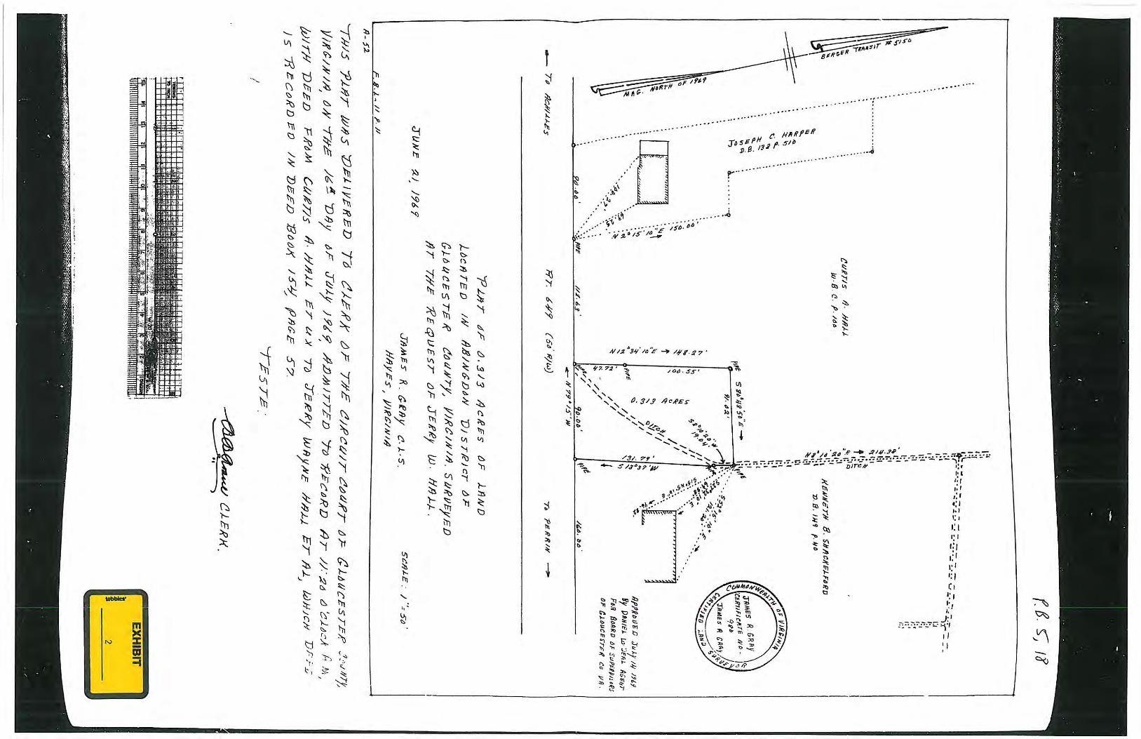
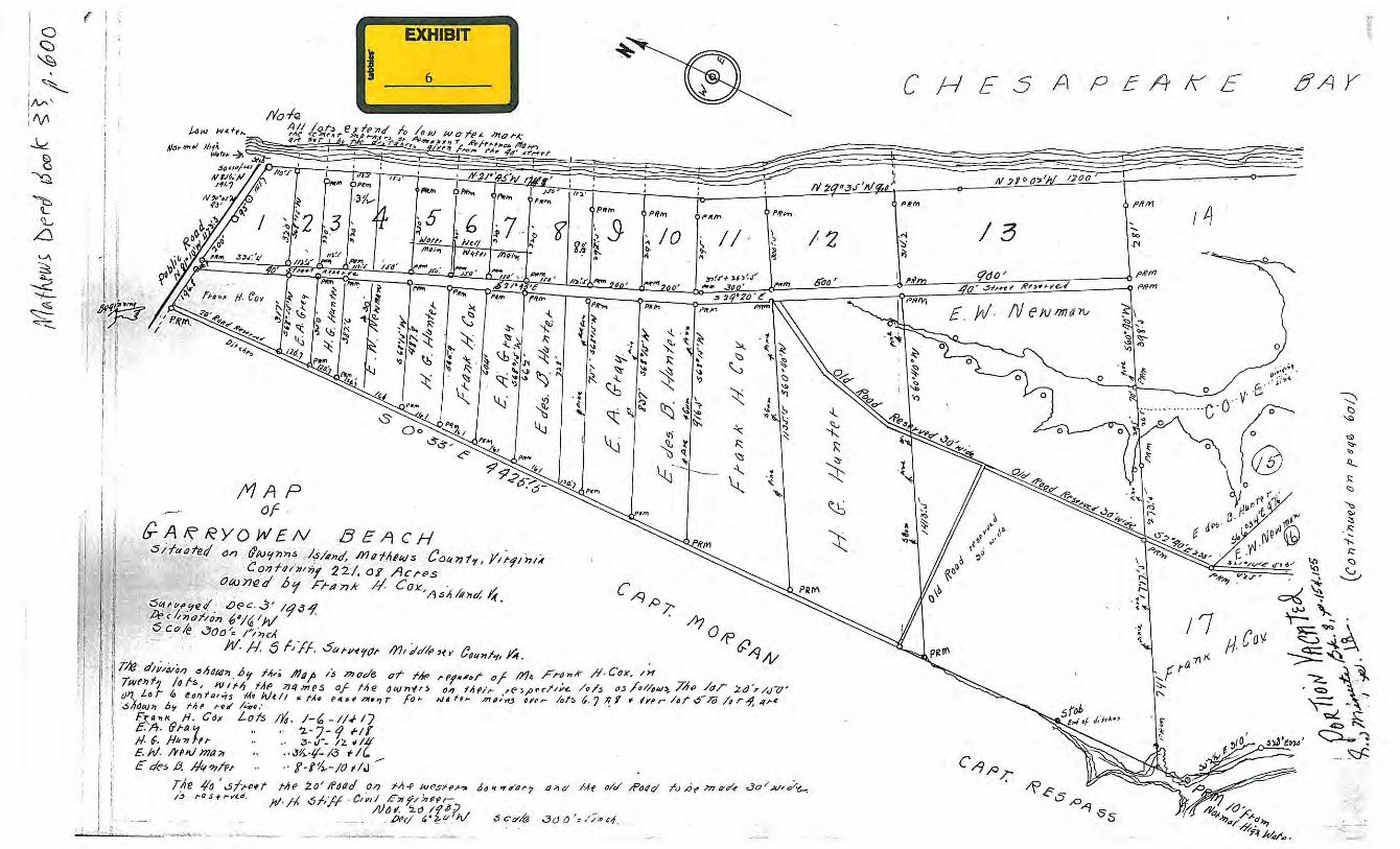
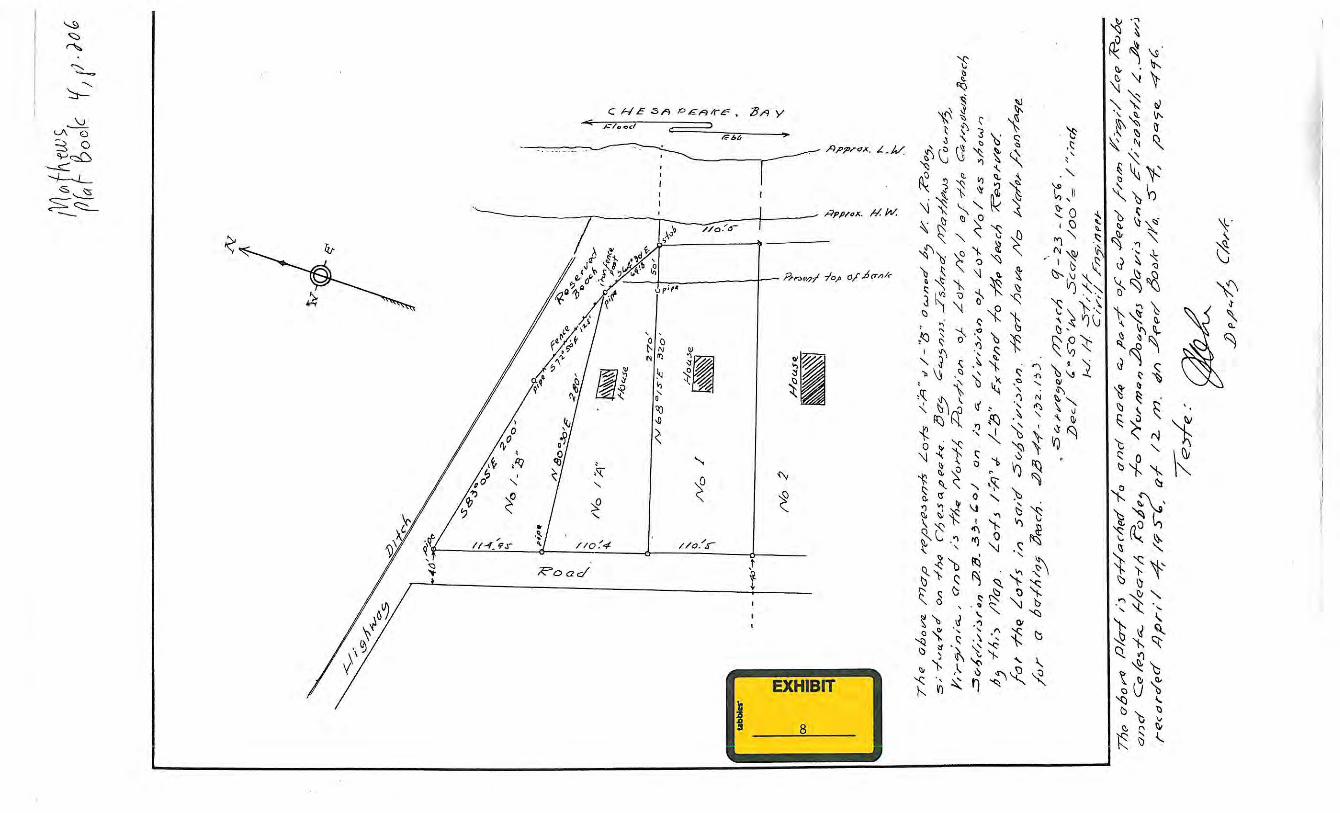
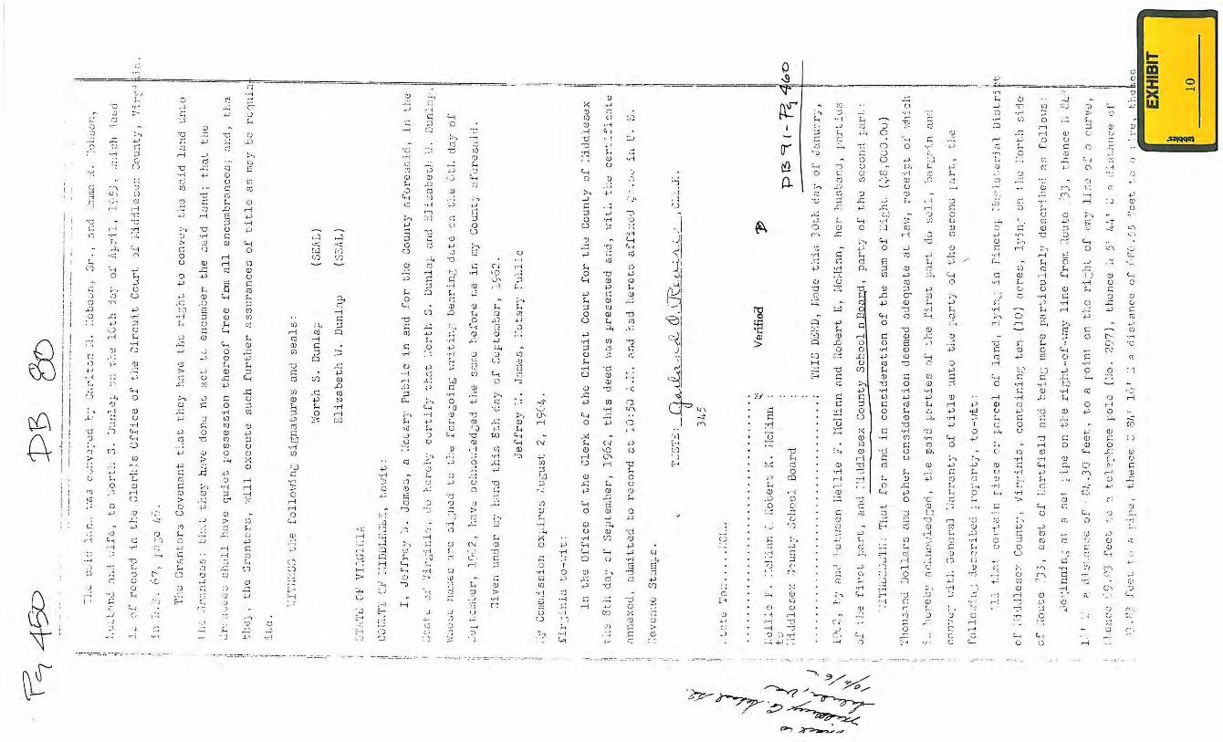
Exhibit 1: Aerial photograph of outfall ditch between 9455 and 9469 Maryus Road Exhibit 2: 1969 plat of the front part of 9455 Maryus Road, Gloucester County Plat Book 5, page 18 Exhibit 3: 1965 plat of the property behind 9455 Maryus Road, Gloucester County Plat Book 4, page 91 Exhibit 4: Aerial photograph of 2553 Guinea Circle Road Exhibit 5: 1996 Plat of 2553 Guinea Circle Road, Gloucester County Plat Book 23, page 180 Exhibit 6: 1937 Plat of Cheek Property, Mathews County Deed Book 33, page 600 Exhibit 7: 1952 Plat of Eubank Property, Mathews County Plat Book 1, page 77 Exhibit 8: 1956 Plat of Cheek Property, Mathews County Plat Book 4, page 206 Exhibit 9: Section 2 of Chapter 34 of the Law of Virginia of 1705 Exhibit 10: Middlesex County Deed Book 80, page 450 Exhibit 11: Highway plan sheet for Route 33 Exhibit 12: Middlesex County Deed Book 87, page 527 Exhibit 13: Middlesex County Deed Book 353, page 773
1
ROADSIDE AND OUTFALL DRAINAGE DITCHES I. PURPOSE The purpose of this report is to analyze various legal and ownership issues associated with a handful of ditches along Virginia Department of Transportation (“VDOT”) roads which have proven to be problematic at the local level. The report will set forth the general rules of law with regard to water flow from one property to another, the collection and distribution of the water in channels such as ditches, the responsibilities for the maintenance of such channels or ditches and the legal liabilities and responsibilities that result from excessive collection or flows of water created by the artificial courses of water or increases to natural courses of water. The report analyzes seven selected ditches and makes recommendations of methods of analyzing and resolving future problems related to similar circumstances. II. LEGAL ANALYSIS Virginia has adopted the modified common law rule with regard to surface water. Under this doctrine, surface water is a common enemy and each landowner may fight it off as best he can, provided he does so reasonably, in good faith and not wantonly and unnecessarily or carelessly so as to injury another’s property. Kurpiel v. Hicks, 284 Va. 347, 731 S.E.2d 921 (2012), citing McGehee v. Tidewater Railway Company, 108 Va. 508, 62 S.E. 356 (1908). Virginia recognizes at least two exceptions to the modified common law rule. One exception is that a landowner cannot collect surface water into an artificial channel or volume and pour it upon the land of another to his injury. Seventeen, Inc. v. Pilot Life Insurance Co., 215 Va. 74, 205 S.E.2d 648 (1974). Another exception is that landowner cannot interfere with the flow of surface water in a natural channel or stream in such a manner as to cause injury to the land of another. Mullins v. Greer, 226 Va. 587, 311 S.E.2d 110 (1984); McGehee v. Tidewater Railway Co., 108 Va. 508, 62 S.E. 356 (1908). While a landowner may turn surface water back on its neighbor, it cannot interfere with the flow of surface water in a natural channel. Howlett v. City of South Norfolk, 193 Va. 564, 69 S.E.2d 346 (1952). The following cases give examples of how these general rules have been applied. In Seventeen, Inc. v. Pilot Life Insurance Company, 215 Va. 74, 205 S.E.2d 648 (1974), a landowner developed agricultural property into a shopping center. To facilitate the flow of the increased surface water, the landowner replaced an 18 inch pipe under an adjoining roadway with a 48 inch pipe. Even though there was a downstream drainage easement, the amount of water coming off the shopping center was so much greater than the runoff from the farm and the amount of water flowing through the 48 inch pipe was so much greater than the amount that would flow through an 18 inch pipe, the increased volume was deemed to be unreasonable. In a similar case, a downhill landowner had a ditch through his property. At the end of the ditch, he had placed a 12 inch pipe under a roadway. That ditch was sufficient to hold the water from his land and the water that came naturally off a 26 acre tract above him. A new owner of the 26 acre tract erected large apartment houses and constructed streets. He also gathered the water running off his property into a two foot diameter pipe which ended a few
2
inches from the land of the downhill owner. Although the downhill owner had a ditch through his property, the increased amount of water and the concentration of that water caused extensive damage to his property and was deemed unreasonable. The downhill owner was entitled to damages as a result. Third Buckingham Community, Inc. v. Anderson, 178 Va. 478, 17 S.E.2d 433 (1941). The construction of a road can create a natural dam if it is built higher than the surrounding land. The party that constructs the road may become liable for the interference with natural drainage if it does not install adequate culverts to take care of the surface water, causing water to accumulate on an adjoining lot. In Raleigh Court Corporation v. Faucett, 140 Va. 126, 124 S.E. 433 (1924), a culvert was placed under a road. However, it was placed at a depth 8 inches above the surface of an adjoining owner’s lot. This caused up to 8 inches of water to stand on the plaintiff’s lot whenever there was a heavy rain. The failure to properly install the culvert resulted in liability. Once water is in a well defined channel, a property owner generally cannot interfere with its flow. Howlett v. City of South Norfolk, 193 Va. 564, 69 S.E.2d 346 (1952). Nevertheless, a landowner can change the course of a stream on its property. As long as the stream exits its property at the same point and no additional water is included, there is no liability on the owner. Cook v. Seaboard Air Line Ry., 107 Va. 32, 57 S.E. 564 (1907). On the other hand, if, in rerouting the natural watercourse, additional water is placed on another landowner to that landowner’s detriment, the rerouting of the watercourse will be deemed unreasonable. Mullins v. Greer, 226 Va. 587, 311 S.E.2d 110 (1984). Municipalities and other governmental entities are not exempt from these rules. They have the same obligations as landowners when they construct public improvements, including streets, on property that they own or control. Howlett v. City of South Norfolk, 193 Va. 564, 69 S.E.2d 346 (1952). However, a municipality is not liable for damage caused by the flood of an artificial channel it created if the damage was due to an extraordinary rainfall. City of Portsmouth v. Weiss, 145 Va. 94, 133 S.E. 781 (1926). The court defined extraordinary rainfall to mean a rainfall that is so unusual and extraordinary that men of ordinary prudence would not have anticipated and provided for it. It does not mean a larger downpour of rain than had ever previously occurred.
This law has been consistently interpreted and applied since 1895. However, few cases
have specifically addressed maintenance of ditches. In Jenkins v. County of Shenandoah, 246 Va. 467, 436 S.E.2d 607 (1993), a county accepted the dedication of a drainage easement which it chose not to maintain. The Supreme Court held that the county’s failure to maintain the drainage ditch did not absolve it of liability. When the county accepted the dedication of the easement, it “also accepted the burden of maintaining it in the manner necessary to protect the servient estates”. Jenkins v. County of Shenandoah, 246 Va. at 471, 436 S.E.2d at 610.
The Supreme Court handed down another decision last year dealing with responsibility
for maintenance of a ditch. Livingston v. Virginia Department of Transportation, 284 Va. 140, 726 S.E.2d 264 (2012), related to the relocation of Cameron Run, a natural stream, as part of the construction of the Capital Beltway in Fairfax County. Over a period of 35 years, significant

3
sediment accumulated in the relocated Cameron Run, but VDOT did not dredge the sediment. A significant storm produced “long periods of precipitation with high intensity downpours”, causing the flow depth of Cameron Run to increase in less than two hours from just under 2 feet to almost 14 feet. That was the second highest water flow in Cameron Run in over 50 years, topped only by Hurricane Agnes. That storm caused the water in Cameron Run to overflow, damaging nearby property. The Court held that the reconstruction of the channel did not make VDOT an insurer in perpetuity against flood damage. However, it found that the new channel may have worked without flooding if it had been properly maintained. Therefore, VDOT was liable for the damage caused by its operation of the relocated Cameron Run, “including its failure to maintain” it.
III. ANALYSIS OF EACH SELECTED DITCH A. Gloucester County: Outfall ditch adjacent to 9455 Maryus Road and 9469 Maryus Road. I visited all seven ditches on March 22, 2013. The specific ditch at issue at this location is an outfall ditch for the ditches on the north side of Maryus Road (State Route 649). It is located between 9455 and 9469 Maryus Road, which are owned by Joann Hall and Anthony and Jennifer Quintero, respectively. The water in the outfall ditch does not effectively drain. Instead, the outfall ditch is filled most of the time. According to Garrey Curry, Director of Public Works for Gloucester County, there is water in the roadside ditches all along Maryus Road almost year round, except in periods of drought. In March, all the ditches along that part of Maryus Road had standing water with algae in them. The water in the outfall ditch was not perceptibly moving at that time. VDOT maintains the ditches along the road, but does not maintain the outfall ditch. The ditch in front of 9455 Maryus Road is about 5’ wide. The centerline of Maryus Road is about 15’ from the closest bank of the ditch and about 20’ from the far side of the ditch. VDOT has a prescriptive easement in Maryus Road, which means that its right-of-way is only 30’ wide (Va. Code § 33.1-184). Therefore, the roadside ditches are almost all entirely outside the right-of-way and the outfall ditch is outside of the right-of-way. Based upon a diagram on an aerial photograph (Exhibit 1), the outfall ditch goes in a straight line northward along a property line dividing several parcels to a creek or watercourse. It is about 1,200 feet long. Although a line depicting the outfall ditch is drawn in a straight line on the aerial map, the image on the photograph appears to veer slightly away from the straight property boundary line. A search of the titles to the properties that abut the outfall ditch did not disclose any easements. The properties on both sides of the outfall ditch at Maryus Road were part of a single parcel conveyed by B. A. and Cornelia Rowe to Armstead Hall in 1895. (Gloucester Deed Book 20, page 256). The Hall family divided the property among themselves, probably after Armstead’s widow died in 1965. I could not find a plat showing the division. If there is an easement, it would have likely been created then.
4
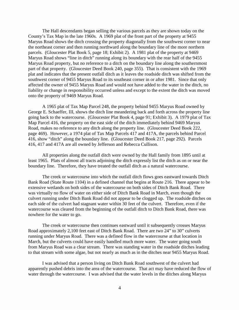
The Hall descendants began selling the various parcels as they are shown today on the County’s Tax Map in the late 1960s. A 1969 plat of the front part of the property at 9455 Maryus Road shows the ditch crossing the property diagonally from the southwest corner to near the northeast corner and then running northward along the boundary line of the more northern parcels. (Gloucester Plat Book 5, page 18; Exhibit 2). A 1981 plat of the property at 9469 Maryus Road shows “line in ditch” running along its boundary with the rear half of the 9455 Maryus Road property, but no reference to a ditch on the boundary line along the southernmost part of that property. (Gloucester Deed Book 240, page 355). That is consistent with the 1969 plat and indicates that the present outfall ditch as it leaves the roadside ditch was shifted from the southwest corner of 9455 Maryus Road to its southeast corner in or after 1981. Since that only affected the owner of 9455 Maryus Road and would not have added to the water in the ditch, no liability or change in responsibility occurred unless and except to the extent the ditch was moved onto the property of 9469 Maryus Road. A 1965 plat of Tax Map Parcel 248, the property behind 9455 Maryus Road owned by George E. Schaeffer, III, shows the ditch line meandering back and forth across the property line going back to the watercourse. (Gloucester Plat Book 4, page 91; Exhibit 3). A 1979 plat of Tax Map Parcel 416, the property on the east side of the ditch immediately behind 9469 Maryus Road, makes no reference to any ditch along the property line. (Gloucester Deed Book 222, page 469). However, a 1974 plat of Tax Map Parcels 417 and 417A, the parcels behind Parcel 416, show “ditch” along the boundary line. (Gloucester Deed Book 217, page 292). Parcels 416, 417 and 417A are all owned by Jefferson and Rebecca Cullison. All properties along the outfall ditch were owned by the Hall family from 1895 until at least 1965. Plats of almost all tracts adjoining the ditch expressly list the ditch as on or near the boundary line. Therefore, they have treated the outfall ditch as a natural watercourse. The creek or watercourse into which the outfall ditch flows goes eastward towards Ditch Bank Road (State Route 1104) in a defined channel that begins at Route 216. There appear to be extensive wetlands on both sides of the watercourse on both sides of Ditch Bank Road. There was virtually no flow of water on either side of Ditch Bank Road in March, even though the culvert running under Ditch Bank Road did not appear to be clogged up. The roadside ditches on each side of the culvert had stagnant water within 30 feet of the culvert. Therefore, even if the watercourse was cleared from the beginning of the outfall ditch to Ditch Bank Road, there was nowhere for the water to go. The creek or watercourse then continues eastward until it subsequently crosses Maryus Road approximately 2,100 feet east of Ditch Bank Road. There are two 24” to 30” culverts running under Maryus Road. There was a defined flow in the watercourse at that location in March, but the culverts could have easily handled much more water. The water going south from Maryus Road was a clear stream. There was standing water in the roadside ditches leading to that stream with some algae, but not nearly as much as in the ditches near 9455 Maryus Road. I was advised that a person living on Ditch Bank Road southwest of the culvert had apparently pushed debris into the area of the watercourse. That act may have reduced the flow of water through the watercourse. I was advised that the water levels in the ditches along Maryus
5
Road are higher now than prior to the debris being pushed into the watercourse. I could not confirm the accuracy of that information. However, if action was taken that interfered with the flow of surface water in an actual channel such as this watercourse, that person could be liable for any damage caused by flooding of that channel. Howlett v. City of South Norfolk, 193 Va. 564, 69 S.E.2d 346 (1952). Such conduct could also violate Gloucester County Ordinance § 8.5-36(b) which provides that “Under no circumstance shall any use, activity, and/or development adversely affect the capacity of the channels or floodways of any watercourse, drainage ditch, or any other drainage facility or stream.” Such action might have also violated EPA statutes and regulations. Otherwise, the problem with the outfall ditch appears to be an act of nature rather than any lack of maintenance. Although the level of standing water in the outfall ditch and the roadside ditches on Maryus Road could have been increased in part by a clogged ditch or debris in the watercourse, the channel downstream from the Ditch Bank Road culvert was hardly moving with standing water in it. Unless there is a significant blockage of that channel between Ditch Bank Road and the Maryus Road culvert, the primary cause of the lack of flow in the outfall ditch is the lack of change of elevation. The water level in Mobjack Bay appears to be not much lower than the water level in the watercourse, causing the slow movement of the water all the way back to 9455 and 9469 Maryus Road. The ability of any ditch to drain water is primarily dependent on elevation change. There is very little elevation change through this area. Therefore, the water will essentially stand still because there is nowhere for it to go. Neither VDOT nor the County has a drainage easement in the outfall ditch. Therefore, neither has any right or responsibility to clear the outfall ditch. VDOT is responsible for clearing the ditches along the road because those ditches channel water from the road. However, cleaning those ditches would not reduce the level of water in the outfall ditch. Therefore, except for the person who may have placed debris in the channel, there appears to be no person or entity responsible for the standing water in the outfall ditch. B. Gloucester County: Outfall ditch adjacent to 2553 Guinea Circle Road The problem with the outfall ditch at 2553 Guinea Circle Road (State Route 652) is that it backs up and floods Guinea Circle Road during periods of heavy rain. This outfall ditch is not well defined. In March, the culvert under the road was entirely underwater on both sides. There was a flow of water leading to the culvert on the other side of the road, so some water was moving. Nevertheless, the water on the outfall side was not visibly moving. The outfall ditch had much growth in it, but there was no visible debris deposited by anything other than the force of nature. Outfall ditch is a misnomer at this location. Based on the County Tax Map, the water comes to Guinea Circle Road from the west by way of a natural stream. That watercourse continues east of the road. The watercourse is a clearly defined channel from Guinea Circle Road to well beyond Belvin Farm Road. (Exhibit 4).

6
Guinea Circle Road is a potential dam to the watercourse. Since VDOT’s road cannot act as a barrier to the passage of water, it must have culverts adequately sized to allow the continued flow of water. Based on the lack of flow of water in the downstream (east) side of the culverts, the culverts do not appear to be undersized. They are not causing the outfall ditch to be full of water. We did not walk along the outfall ditch from Guinea Circle Road. However, we did drive down Belvin Farm Road to the point at which the natural watercourse passes under the road. At that point, the watercourse was well defined and flowing well into and through a 24 inch pipe. Based on the level of the ice around the downstream side, it was probably low tide at the time of the site visit because the water had been at least 6 inches to 12 inches higher overnight. Therefore, the blockage, if any, is between Guinea Circle Road and Belvin Farm Road. The watercourse on the east side of Guinea Circle Road follows a boundary line between the owners of Tax Map Parcels 108 and 31 on the south and east sides (Shell and Calvin French and Big OK Enterprises, respectively) and Parcels 8 and 13 on the north and west sides (Michael Pels and Ashley Ann Winebarger and Nikola and Vesne Janjic, respectively). That boundary line runs for almost half the distance from Guinea Circle Road to Belvin Farm Road following the meander of the watercourse. There is only one plat in the chain of title of 2553 Guinea Circle Road, which is owned by Pels and Winebarger and located on the north side of the outfall ditch. The boundary line that follows the ditch is described in a plat as “line in stream.” (Gloucester Plat Book 23, page 180; Exhibit 5). No plat was found for the property behind it, Parcel 53-13, but a 1952 deed in the chain of that title describes the property as bounded by a creek on the east. (Gloucester Deed Book 92, page 432). On the south and east sides of the ditch, there are no references to the ditch, creek or stream in the chain of title of either Parcel 53-108 or Parcel 53-31 going back to at least 1940. No language creating an easement was found in any of the deeds. However, based on the aerial photograph, the 1996 plat and the 1952 deed, this is a natural creek or stream. Therefore, this outfall ditch is a natural watercourse and no one has the obligation to maintain it. It is possible that, if the watercourse were cleaned out between Guinea Circle Road and Belvin Farm Road, the water would flow faster and the outfall ditch would not remain full. However, because neither VDOT nor the County has any easement, they have no responsibility to maintain the ditch. Only the landowners on each side of the watercourse have the right to maintain it or otherwise clear it out. The landowners may not restrict the flow of water in a way to harm others, but they do not have an affirmative duty to clear or maintain it unless they do something that unreasonably increases the flow of water into it. Therefore, if the growth that clogs up the stream is natural and the adjoining owners have done nothing to cause that to occur or to become worse, they have no liability.

7
C. Gloucester County: Outfall ditch adjacent to 2763 Guinea Circle Road The problem with the outfall ditch at 2763 Guinea Circle Road (State Route 652) is that it also backs up and floods Guinea Circle Road during periods of heavy rain. There are two culverts on the west side of the road across from 2763 Guinea Circle Road. There was flow coming into them from two different watercourses in March. On the east side, there was visible flow about 15 inches past the two pipes. The waterline was almost up to the top of the pipes. When Garrey Curry had been there two weeks earlier, the roadside ditch had much less water in it. Outfall ditch is also a misnomer at this location. There are two defined watercourses flowing from the west to Guinea Circle Road which merge to become one watercourse east of the road. They appear to be natural channels. The outfall ditch is a continuation of that merged watercourse. The watercourse flows through 2763 Guinea Circle Road, which is Tax Map Parcel 53-15 and owned by Steven J. Carter. This parcel was owned by A. J. Hogge at the time of his death in 1940. Hogge also died owning Parcel 53-3, which adjoins the larger watercourse on the western side of Guinea Circle Road and through which the smaller watercourse flows. There is no easement in the chain of title to 2763 Guinea Circle Road. Guinea Circle Road is a potential dam where the two watercourses converge. Since VDOT’s road cannot act as a barrier to the passage of water, it must have culverts adequately sized to allow the continued flow of water. Based on the amount of water on the downstream (east) side of the culverts, the culverts do not appear to be undersized. There was a fair amount of debris to the left of the channel on the east side of the road that was left over from an earlier storm, an overflow of water across the road or someone’s effort to clean out the ditch. However, that debris was not in the channel itself. The blockage, if any, is downstream of Guinea Circle Road. It is possible that, if the downstream channel were cleaned out, the water would flow faster and the stream would not remain full. However, neither VDOT nor the County has a drainage easement down the watercourse so neither has any responsibility to maintain that ditch. Unlike the first two ditches, this watercourse goes through a single parcel rather than along a boundary line between two parcels. Only the landowner has the right to maintain it or clear it out. The landowner may not restrict the flow of water in the watercourse through his property in a manner that harms others, including causing flooding of Guinea Circle Road or the property at 2763 Guinea Circle Road. However, he has no affirmative duty to clear it or otherwise maintain it. If the growth that clogs up the watercourse is natural, he has no liability. On the other hand, if he has done something to clog the watercourse or to otherwise impede the flow of water through the watercourse, he may have some responsibility to clear out the obstruction.
8
D. Gloucester County: Outfall ditch adjacent to 7479 Brays Point Road According to Mr. Curry, there has not yet been a problem with the ditches along Brays Point Road, the culverts at 7479 Brays Point Road (Route 636) or the outfall ditch. However, his concern relates to future drainage from potential development of Woodville Park which could be collected in the roadside ditch and flow to the subject culverts and outfall ditch. The outfall ditch appears to be a natural watercourse. In March, there was excellent flow into and out of the culvert at that location. There is a large headwall with two 36 inch pipes at the outfall ditch. We could see a flow going into the culvert. Although we could not see any obvious flow in the outfall ditch itself, the ditch appeared to be about 10 feet wide and fairly deep. There are ditches along the north side of Bray’s Point Road flowing toward the culvert. There was very little water in the ditch east of the culvert. Most of the water was coming down the road from Woodville Park and other properties to the west of the culverts. The subject outfall ditch was therefore carrying the Woodville Park water as well as water it has historically carried. If the roadside ditch and the outfall ditch become overwhelmed by excess water, it will likely have been created by the development of Woodville Park or other properties along Brays Point Road. As with all owners, the County has the right to divert water from its property in a reasonable manner. Diverting it into the roadside ditch along Brays Point Road puts it into a channel, which is permissible. However, if its use of the property adds so much water that the channel cannot handle it and causes problems to landowners on the same side of the road or if it forces the water through the culverts under Brays Point Road in such a way as to damage property on the other side, the County could become liable under the rules set forth in Kurpiel v. Hicks, 284 Va. 347, 731 S.E.2d 921 (2012). Accordingly, adding more water to the flow in the ditch would not in and of itself be a problem. However, an unreasonable amount of extra water could create liability on the County if the ditches and culverts cannot handle it. E. Mathews County: Outfall ditch at end of Old Ferry Road The problem at this location is that the beach is being eroded by the water that flows out of the outfall ditch beyond the end of State maintenance of Old Ferry Road (Route 633). The owners of the property to the north of Old Ferry Road, Christine and Mark Eubank, have recently improved the ditch from the end of State maintenance to the beach. Rather than flowing directly from the end of the ditch to the Bay, the water has cut a zigzagging channel across the beach. Old Ferry Road ends about 150 feet short of the Chesapeake Bay. It terminates on the end of the asphalt, approximately 95 feet before the beach. That extra 95 feet consists of a graveled roadway which curves and extends to the right. It ends at a drop off at the edge of the beach. The State maintained asphalt roadway is approximately 10 feet wide.
9
Two large pylons have been placed in the sand. According to Sue Thomas, an Environmental Planner for Mathews County, the pylons were installed in the last two years by the Eubanks. The two pylons in the sand are approximately 30 feet from the bulkhead to the right. If the State maintained portion of the road were extended straight to the Bay, the taller left hand pylon would be in the 10 foot line of pavement, approximately a foot or two from the left hand side of it. The bulkhead and the two posts are not parallel to Route 633 and do not approximate a direct extension of the 30 foot right-of-way, although such a 30 foot right-of-way would pass through that area. The road has been shown as a public road on plats of the properties south and north of the road since 1937 and 1952. (Mathews Deed Book 33, page 600 and Plat Book 1, page 77; Exhibits 6 and 7, respectively). The road was shown extending to or within 50 feet of the normal high water mark on those plats. They also showed the road as a straight line. A 1956 plat of the property south of the road, now owned by Edward and Evelyn Cheek, showed the southern edge of the roadway flaring somewhat more to the south, beginning at the approximate location of the current end of State maintenance. That plat described the area beyond what is now the end of State maintenance as “Reserved Beach”. (Mathews Plat Book 4, page 206; Exhibit 8). The Old Ferry Road ditch line follows generally the VDOT right-of-way leading up to the end of State maintenance. It could be within the 30 foot right-of-way because it appears to be within 10 feet of the edge of pavement. There is a culvert that runs under Sweet Gum Road, so that the water leading up to the riprap is largely coming from the runoff along Old Ferry Road. The ditch curves away from the right-of-way and the graveled road bed at the end of the VDOT right-of-way. In 2012, the Eubanks improved that ditch beyond the end of State maintenance pursuant to a permit from the County. The plans submitted with the permit application show the proposed riprap well off the VDOT right-of-way. It indicates that the existing ditch was along the property line. The Eubanks installed riprap from adjacent to the end of State maintenance to the beach. At no location is the riprap on the VDOT property. The riprap has apparently cleaned the water because the water on the downstream side of the riprap looked quite clear and was flowing. Ms. Thomas stated that it was previously “dirty”. Rather than going straight to the Bay, the water has cut a channel in the sand after it flows out of the riprap portion of the ditch. It makes a 90 degree turn to the right at the larger of the two pylons. It runs to a jetty and then turns left towards the Bay. However, it cuts back horizontally to the left as it nears the Bay before angling into the Bay. The channel does not enter into a straight line extension of Old Ferry Road until well into the beach. All of the erosion of the beach is either on the Eubank property or on the straight line extension area. According to Ms. Thomas, a nor’easter did substantial damage about 4 or 5 years ago, taking away much of the land along this area and washing out most of the sand. The fourth house going north on Sweet Gum Lane from Old Ferry Road actually fell into the water because it was undermined. She said that prior to the nor’easter the water from the ditch on the north side of Old Ferry Road went in a channel in a straight line to the Bay. The current curving channel
10
on the beach is new. She said there is much more sand on the beach here now than there had been. The jetties were put in to catch the sand and they are doing their job. The straight line extension of Old Ferry Road is likely to be a prescriptive easement to the beach. While the name of the road might indicate that it is a former public landing, it is much more likely that the “old ferry” crossed Milford Haven at the other end of Old Ferry Road, where the Route 223 bridge is located. It is unlikely that there was a ferry across the Bay from the subject road ending. Instead, this was probably just the end of the road. Based on the plats, this has been treated as a public road for many years. It was likely maintained by the County prior to the enactment of the Byrd Road Act, which transferred county control of public roads to VDOT’s secondary road system. VDOT made early administrative decisions as to which roads and which parts of roads to include in its secondary system. The end of State maintenance marks the end of the portion of the road that VDOT apparently chose to accept into the system. However, failure to accept the rest of the road into the system did not eliminate the public’s right to use the road. The Code of Virginia establishes certain presumptions as to the existence of public roads:
When a way has been worked by road officials as a public road and is used by the public as such, proof of these facts is prima facie evidence that the same is a public road. And when a way has been regularly or periodically worked by road officials as a public road and used by the public as such continuously for a period of twenty years, proof of those facts shall be conclusive evidence that the same is a public road. In all such cases, the center of the general line of passage, conforming to the ancient landmarks where such exist, shall be presumed to be the center of the way and in the absence to proof to the contrary the width shall be presumed to be thirty feet. (Va. Code § 33.1-184) (emphasis added).
This 30 foot presumption predates the Byrd Road Act of 1932 by 227 years. Section 2 of Chapter 34 of the Law of Virginia of 1705 provided that every road shall be “at least thirty foot broad”. (Exhibit 9). That 30 foot width provision has been reenacted regularly over the last 300 years. (See for example, 1748 Laws of Virginia, Chapter 28, § 6; 1785 Code of Virginia, Chapter 75, § 6; 1819 Code of Virginia, Vol. 2, Chapter 236, § 7, page 235; 1860 Code of Virginia, Chapter 52, § 5, page 298; 1874-1875 Acts of Assembly, Chapter 181, page 177; 1908 Acts of Assembly, Chapter 388, page 674; Virginia Code of 1919, § 2015; 1928 Acts of Assembly, Chapter 159, § 31, page 580).
Therefore, the public probably has a prescriptive easement in a 30 foot right-of-way
running along a straight line extension of Route 633 past the end of State maintenance to the Bay. That line does not match the current graveled portion of the roadway. Even if there is no proof of public maintenance, the 1937 and 1952 plats reflect the public’s right to use the extended roadway. The Eubanks and the Cheeks may own the underlying title up to the center line of the 30 foot prescriptive easement on their respective sides. However, no deed in their chains of title claims ownership of the prescriptive easement area.

11
VDOT’s responsibility ends at the end of State maintenance. If VDOT never accepted the rest of the roadway for maintenance, it never became VDOT’s responsibility. If VDOT has discontinued the rest of the roadway, it ceased to be VDOT’s responsibility at the time of discontinuance. Under either circumstance, the public likely has access across the rest of the roadway as a prescriptive easement. To the extent the County chooses, it may maintain the rest of the road, but it has no duty to maintain roads or their ditches not in the State’s secondary system pursuant to the Byrd Road Act. Most of the water in the ditch, including the riprap portion, comes from Old Ferry Road. Since Old Ferry Road and the ditch line along the road predate its acceptance into the secondary system, the ditch was a natural channel when VDOT become responsible for the road. That would not relieve it of liability if it took action that unreasonably increased the flow of water into the ditch. However, there does not appear to be anything done by VDOT to increase the flow. The ditch was properly carrying water toward the next watercourse, the Bay.
It appears that the present erosion of the beach was created by the improvements made to the roadside ditch by the Eubanks. However, all damage from their improvement is either on property they own or on the prescriptive easement area. The former outfall ditch from the end of the roadside ditch went straight to the Bay, which made it a part of the natural channel and watercourse flowing from the end of the roadside ditch. Neither VDOT nor the County has any responsibility for doing anything to take the water from the end of the riprap improvement into the Bay. F. Mathews County: Outfall ditch at Old Ferry Road, South Bay Haven Road and North Bay Haven Road intersection The problem at this intersection is that at least one of the ditches frequently overtops its banks during and after a storm event. Therefore, the problem is primarily a flooding issue. None of the ditches were overflowing in March or August. The water at the northeast corner goes into a culvert that runs cater-corner across the road. It outlets into the ditch at the southwest corner. South Bay Haven Road goes toward Milford Haven Bay. The roadside ditch on the west side of the road turns away from the road not far from an inlet of that bay and takes the water toward the inlet. There is no ditch at the northwest corner of Old Ferry Road where the Post Office is located. The water was not up to the top of the culvert in March. On the southwest corner, the ditches along both South Bay Haven Road and Old Ferry Road were not completely full, but they had much standing water with algae. The same situation occurred at the northeast corner and the ditches on North Bay Haven Road and Old Ferry Road. The only perceptible flow in any of the ditches at that corner in March was at the first driveway on North Bay Haven Road. The water was flowing towards the intersection. That would indicate that the culvert was working. A sidewalk culvert on the northeast side of Old Ferry Road going towards the culvert looked completely covered on the upstream side, but there was very little water backed-up. This means that the debris was not preventing the flow of water in the ditch. While we were at the site in March, Ms. Thomas talked with Ms. Kendall, the

12
Postmaster at this Post Office. Ms. Kendall said that the road does not flood as often or as badly as it used to. When I went back to the intersection on August 1, 2013, the ditches had no standing water in them, even though the prior two months had been very wet and it had been raining some during the day. Later that day, I went back to Gwynn’s Island near the end of a sustained downpour. There was water standing in the southeast side ditch along Old Ferry Road between the intersection and the first driveway culvert. Otherwise, there was no water standing at any of the ditches on the south side of Old Ferry Road. There was also water standing in the northwest curve closest to the post office where there is no ditch. There was no water in the ditch line along Old Ferry on the north side, but there was water in the ditch on North Bay Haven Road through at least the first three driveway culverts. There was no perceptible flow at either end of the pipe under Old Ferry Road. The problem at this intersection appears to be a lack of elevation change. When there is significant rain, such as the afternoon of August 1, the ditches will fill. I saw no evidence of improperly maintained ditches and culverts, with the exception of one culvert on the north side of Old Ferry Road which was not causing any problem. The water did not appear to back up going south on South Bay Haven Road. The ditches along that road were well maintained and the culverts were not full, so they were not impeding the flow of water in the ditches. To the extent the ditches along South Bay Haven Road or the culvert under the intersection are causing flooding, VDOT is responsible for maintaining the ditches and culverts. On the other hand, to the extent the culverts under the private driveways and sidewalks are inadequate and causing flooding, the responsibility is likely on the landowner because those are his or her improvements. However, no one is responsible for flooding caused by extraordinary rainfalls. City of Portsmouth v. Weiss, 145 Va. 94, 133 S.E. 781 (1926). As long as the water stays in the ditches, the ditches are doing their job. They eventually drain, as was evident on the morning of August 1. The next time the road floods, an engineer should examine the ditches and culverts between the intersection and the outfall ditch on South Bay Haven Road to the inlet to see if there is blockage along the way. If not, the problem is a lack of elevation change. G. Middlesex County: Ditch behind YMCA on Route 33 VDOT has a drainage easement onto the subject property. A ditch was extended from the end of VDOT’s easement to the rear of the subject property and into a pipe going onto the property of an adjoining owner, Doug McMinn. At some point, VDOT cleaned out the ditch, although it is not clear whether it cleaned just the VDOT ditch or the entire ditch to the pipe going onto Mr. McMinn’s property. In either event, the cleaning out of the ditch increased the flow of water through the ditch and into the pipe. The increased volume/velocity of the water in the pipe caused damage to Mr. McMinn’s property, leading him to dig up the pipe and effectively dam the end of the ditch. There have been several proposals about how to fix the problem, none of which have yet been realized.

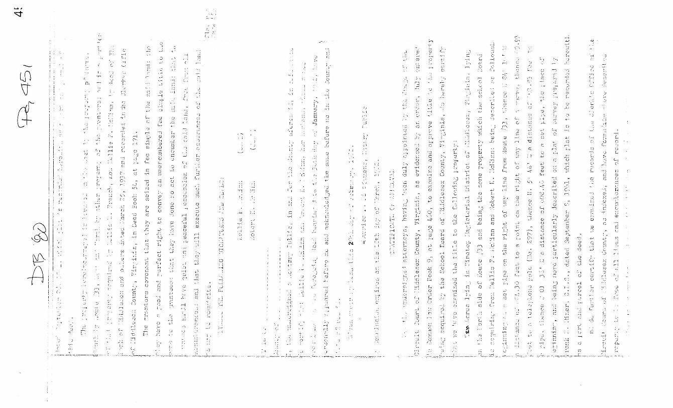
13
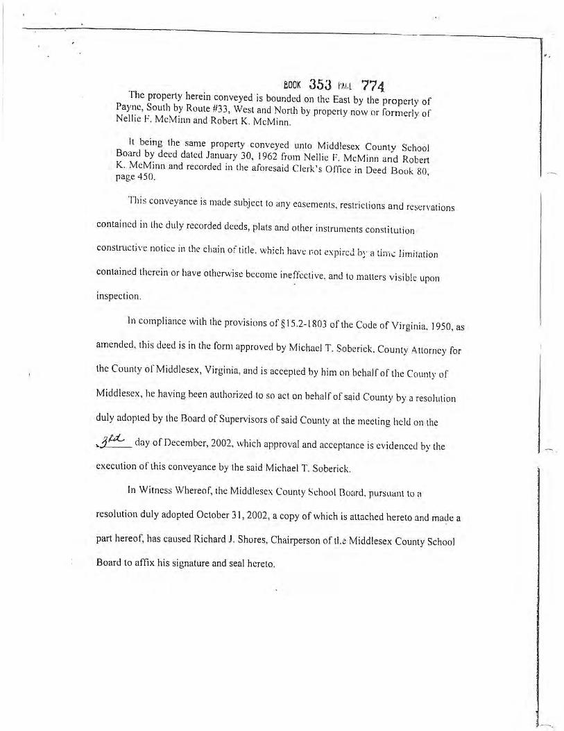
The property is a 10 acre tract. It was purchased by the Middlesex County School Board in 1962 from Nellie and Robert McMinn. (Middlesex Deed Book 80, page 450; Exhibit 10). It is owned by the Middlesex County Board of Supervisors. The property is leased at no cost to the YMCA. The first part of the ditch was constructed as part of improvements by VDOT to Route 33 in the late 1960s. VDOT acquired an easement for the ditch at that time. The easement is clearly delineated on the highway plan sheet running along the east side of the property inside the property line beginning at Route 33. (Exhibit 11). At approximately the same time, the School Board decided to create a playing field in the northeast portion of the property. Before doing so, it needed to take care of excessive water. It therefore extended the ditch from the end of VDOT’s easement to across the northern portion of the property. As part of that project, it obtained a 15 foot wide easement in 1967 from Nellie McMinn that allowed it to run the water in a pipe from the end of the ditch on the School Board’s property 150 feet onto the McMinn property. Under express terms of the deed, the easement would last as long as the School Board was the owner of the property. (Middlesex Deed Book 87, page 527; Exhibit 12). In 2002, the Middlesex School Board conveyed the property to the Middlesex County Board of Supervisors. (Middlesex Deed Book 353, page 773; Exhibit 13). Even though the School Board and the Board of Supervisors are both part of the Middlesex County government, they are separate legal entities and the clause in the deed automatically terminated the easement. Thereafter, the Middlesex County Board of Supervisors was channeling water and putting it onto the McMinn property without authorization. After VDOT cleared out the ditch a couple of years ago, large storms would cause much greater volume and quantity of water to flow into and out of that culvert. When it exited the culvert, it caused significant scouring and other damage to Mr. McMinn’s property. Mr. McMinn was not happy with that situation, so he removed the pipe and dammed the watercourse at the boundary line. The damming worked for Mr. McMinn’s purposes because the area that had been over and beyond the pipe is now dry. A major storm could cause the water to go over the dam, but it would go in sheet form, not in a concentrated form. To the extent Mr. McMinn went onto the Board of Supervisors’ property, he was trespassing and damaging public property. Otherwise, he was within his rights to do what he did. Middlesex County, VDOT and Mr. McMinn worked out an easement arrangement to have the water channeled to a different area. That arrangement had problems related to elevations. In the end, the parties could not agree on all terms of the agreement. The parties are seeking to do a “green” project with the help of VIMS that would follow the old easement and be good for all parties. There is some concern that children playing on the playground would play near the bank of the ditch and fall in. Orange fencing has been installed to screen it off. Based on my observation, the water is being held within the ditch line. It does not appear to have overflowed onto the McMinn property and so does not trigger any legal liability at this time. However, the

14
County has no place to send the water. If the “green” project does not work and the water ponds excessively at the rear of the property, the County may be required to do something that somehow captures and holds the water in a safer and more efficient manner. To the extent the water in the ditch overflows onto Mr. McMinn’s property, any damage resulting from the channeling of the water likely falls on the County, not VDOT. Because the deed of the easement from Mrs. McMinn to the School Board recites the School Board’s desire to build a playground, it is assumed that the easement to VDOT would have adequately handled all water generated by VDOT and that the water from the road did not create the need for the extra easement. Therefore, the channeling done to the rear of the property was done by the School Board for the purpose of improving its property. The County inherited responsibility when it obtained the property. If the assumption about the adequacy of VDOT’s easement is incorrect and highway runoff was the reason the additional easement was needed in the first place, VDOT could have some responsibility and may need to obtain an extension of its drainage easement. IV. RECOMMENDATIONS FOR ANALYSIS OF FUTURE PROBLEMS
The duty to keep ditches clear and maintain them will be determined by the circumstances. If the ditch was created by a single landowner or used to channel excessive water from a single landowner, that landowner would be responsible for damages resulting from the ditch. If a party has a drainage easement for the ditch, that party would be responsible for maintaining the ditch. Jenkins v. County of Shenandoah, 246 Va. 467, 436 S.E.2d 607 (1993). Landowners have the ability to fend off water, but there are limits to that ability. As long as the water is going into a natural watercourse and does not improperly damage adjoining or downstream land, there is typically no liability or obligation to do anything further. The difficult issue with most of these ditches is whether there is a duty to keep the water flowing. This is complicated by the fact that, in many of the outfall ditches, the water is not flowing very well at substantial distances from roadside ditches due to the lack of elevation change and a corresponding lack of flow in the natural watercourses. No party is responsible for such lack of flow if it has not taken some action that impedes that flow in the natural watercourse. However, if that flow has been impeded in an unreasonable manner, the party impeding the flow of water would be liable for any resulting damage. Mullins v. Greer, 226 Va. 587, 311 S.E.2d 110 (1984); Howlett v. City of South Norfolk, 193 Va. 564, 69 S.E.2d 346 (1952). If the ditch is a natural watercourse or has been in existence for many years, it must be determined whether there has been an excessive increase in the amount of water going into it. For example, if a property that had previously been unimproved becomes improved with an extensive area of impermeable surface, such as multiple buildings, asphalt parking lots or a large road system, the party creating the excessive amount of water runoff may be responsible for an unreasonable increase in the water placed into the natural channel. Nevertheless, every landowner has the right to reasonably develop its property and to fend off water. Its only other limitation is that it cannot collect the water in a volume and pour it upon the land of another to

15
his injury, such as occurred in Seventeen, Inc. v. Pilot Life Insurance Co., 215 Va. 74, 205 S.E.2d 648 (1974). That situation could occur on Brays Point Road, depending on how water is handled at the Woodville Park development and how extensive the development of Woodville Park may become. If the problem is that a ditch has become clogged, it must be determined why the ditch is clogged. If the clogging is caused by natural growth in it, it is possible that no party is responsible. However, if a party created or relocated a channel on or along its property in such a manner that caused it to become clogged or handle less water, the party may have responsibility to maintain the ditch. Livingston v. Virginia Department of Transportation, 284 Va. 140, 726 S.E.2d 264 (2012). Therefore, VDOT may have a responsibility to keep roadside ditches clear of natural vegetation so that the flow of water is not impeded. However, if the water does not flow because of a lack of elevation change, VDOT would not be responsible for that standing water. A party with a drainage easement over the property of another has the right to channel water into the easement. However, that party also has a duty to keep the easement area clean enough to allow the flow of water through the channel. Jenkins v. County of Shenandoah, 246 Va. 467, 436 S.E.2d 607 (1993). If a party had an easement to flow water through the property of another and that easement terminates, as was the case with the School Board’s easement onto the McMinn property, the former holder of the easement must then take steps to prevent the flow of the water onto the neighbor’s land in any concentrated flow. To determine the existence of an easement, one must examine the land records. Although certain easements can be implied or created by necessity, that rarely happens with regard to drainage easements. Most drainage easements are express and set forth in a recorded document such as a deed or plat. No one is responsible for a ditch to the extent it is a natural channel. Most of the properties in Gloucester County along the outfall ditches at Maryus Road and Guinea Circle Road had plats or deeds which reflected the existence of the ditch. Designations like ditch, creek or stream indicate that such a ditch is a natural watercourse or has become one over the course of many years. Therefore, any adjoining landowner has the right to channel its water into that ditch, creek or stream so long as it does so in a reasonable manner. In situations in which a ditch overflows and floods a road, like the two ditches at Guinea Circle Road and the ditch at South Haven Bay Road, further investigation is needed to determine the cause. If the cause is an unusually large storm that meets the Supreme Court’s definition of an extraordinary rainfall, no one is responsible. City of Portsmouth v. Weiss, 145 Va. 94, 133 S.E. 781 (1926). If a road floods when water on the downstream side is below road level, then the culvert may be damaged or too small to handle water coming towards the culvert. If the water level on both sides of the culvert are at the same elevation, the problem is likely downstream or simply too much water in too short a period of time.