Report on the 2014 Drilling program at the Wawa Gold Project€¦ · RED PINE EXPLORATION. Report...
30
RED PINE EXPLORATION Report on the 2014 Drilling program at the Wawa Gold Project Report Prepared By: Quentin Yarie, P. Geo. (ON), P. Geo. (NS) And Blake McLaughlin, B.Sc. Date: March 15, 2015 1
-
Upload
duongkhuong -
Category
Documents
-
view
212 -
download
0
Transcript of Report on the 2014 Drilling program at the Wawa Gold Project€¦ · RED PINE EXPLORATION. Report...

RED PINE EXPLORATION
Report on the 2014 Drilling program at the Wawa Gold Project
Report Prepared By:
Quentin Yarie, P. Geo. (ON), P. Geo. (NS)
And
Blake McLaughlin, B.Sc.
Date: March 15, 2015
1

RED PINE EXPLORATION
TABLE OF CONTENTS
Table of Contents ......................................................................................................................................................... 2
List of Tables ................................................................................................................................................................ 3
List of Figures .............................................................................................................................................................. 3
1.0 SUMMARY ......................................................................................................................................... 4
2.0 INTRODUCTION ................................................................................................................................ 5
3.0 PROPERTY DESCRIPTION AND LOCATION .................................................................................. 5
4.0 ACCESSIBILITY, CLIMATE, LOCAL RESOURCES, INFRASTRUCTURE, AND PHYSIOGRAPHY ......................................................................................................................................... 7
ACCESS ....................................................................................................................................................................... 7 CLIMATE ..................................................................................................................................................................... 7 PHYSIOGRAPHY AND VEGETATION .............................................................................................................................. 7 INFRASTRUCTURE AND LOCAL RESOURCES ................................................................................................................ 8
5.0 GEOLOGICAL SETTING AND MINERALIZATION .......................................................................... 8 REGIONAL GEOLOGY .................................................................................................................................................. 8 LOCAL GEOLOGY ....................................................................................................................................................... 9 PROPERTY GEOLOGY ............................................................................................................................................... 10 STRUCTURE .............................................................................................................................................................. 13 MINERALIZATION ...................................................................................................................................................... 13
6.0 EXPLORATION HISTORY ............................................................................................................... 14 PRIOR TO 2007......................................................................................................................................................... 14 PRODUCTION HISTORY ............................................................................................................................................. 17 PRE 2007 DRILLING ................................................................................................................................................. 18 2007 DRILLING ........................................................................................................................................................ 18 2011 DRILLING ........................................................................................................................................................ 19
7.0 CURRENT EXPLORATION: 2014 DIAMOND DRILLING .............................................................. 19 DIAMOND DRILLING CONTRACTOR .......................................................................................................................... 21 CORE HANDLING PROCEDURES ............................................................................................................................... 21 CORE LOGGING ........................................................................................................................................................ 21 STRUCTURE .............................................................................................................................................................. 22 XRF ......................................................................................................................................................................... 22 GEOLOGY ................................................................................................................................................................. 22 MAGNETIC SUSCEPTIBILITY ..................................................................................................................................... 22 CORE RECOVERY ...................................................................................................................................................... 23 CORE PHOTOGRAPHY ............................................................................................................................................... 23 COLLAR SURVEY ....................................................................................................................................................... 23
2
RED PINE EXPLORATION
SAMPLING AND ASSAYS ............................................................................................................................................. 23 DOWN HOLE SURVEYS .............................................................................................................................................. 24
8.0 RESULTS ......................................................................................................................................... 25
9.0 CONCLUSIONS AND RECOMMENDATIONS ............................................................................... 26
10.0 STATEMENT OF QUALIFICATIONS ........................................................................................... 27
11.0 REFERENCES ................................................................................................................................. 29
12.0 APPENDICES (ATTACHED AS SEPARATE FILES) .................................................................. 30 ASSAYS AND CERTIFICATES....................................................................................................................................... 30 CORE LOGS .............................................................................................................................................................. 30 SECTIONS ................................................................................................................................................................. 30 LITHO KEY ............................................................................................................................................................... 30 XRF READINGS ........................................................................................................................................................ 30 MAGNETIC SUSCEPTIBILITY READINGS .................................................................................................................... 30 CORE PHOTOS .......................................................................................................................................................... 30
LIST OF TABLES
Table 1: Past Producres on the Wawa Gold Property ................................................................... 17 Table 2: 2014 Hole Locations, Orientation and Claims where Work was Performed .................. 19 Table 3: Drilling Highlights from 2014 Drill program ................................................................. 25
LIST OF FIGURES
Figure 1: Wawa Gold Project property location and tenure outline ............................................... 6 Figure 2: Regional Geology Map ................................................................................................... 9 Figure 3: Local Geology Map of the Wawa area ...........................................................................11 Figure 4: Property Geology Map .................................................................................................. 12 Figure 5: Wawa Gold Project Property with Claims and 2014 Drilling Locations ...................... 20
3

RED PINE EXPLORATION
1.0 Summary A drilling program was designed during the late fall of 2014 and completed in December of the same year to test and expand gold mineralization in the Surluga deposit on the Wawa Gold Project.
Six (6) holes were drilled into the Surluga deposit to test different zones within the current resource and to also expand what was believed to be higher grade shoots of mineralization which were previously under developed and defined only by historic underground drilling. 702 samples were collected along the lengths of the cores and were submitted for assay.
The mineralized intersections encountered were very promising and yielded significant intervals of gold mineralization. This mineralization predominantly lies within the Jubilee shear which has been described as a 20-50m wide shear zone dipping to the south east at 20-40 degrees.
A large volume of geochemical and structural data was also collected with XRF and a KT-10 magnetic susceptibility meter. The objective of this exercise was not only to provide an effective framework of data collection moving forward, but also to develop ideas and practices which would be reiterated back on the wealth of historic drill core and geological data which exists for the property. Utilization of the Reflex ACTIII tool to orient the core has been implemented throughout this drill program in order to obtain more detailed structural information from drill core. With these tools, the geologists were able to recognize complicated lithologies and alterations. The analysis of this data will aid in further drill targeting as well as provide a more detailed chemical composition of the different rock types encountered in this drill program to date.
Moving forward, it is recommended that further drilling be completed within the jubilee shear in areas where gold mineralization is currently thin or pinched out. By filling in these gaps, a more continuous and thicker mineralized shear should be attainable. Along with this, several mineralized intervals in the hanging wall were intersected. It is recommended that these zones of hanging wall mineralization be tested and delineated. As well as infilling gaps within the current extents of the shear zone, it is also suggested that several drill holes be places in the surrounding areas of the shear to confirm and expand the along strike extensions of this zone.
It is also recommended that thin section petrography be used to further develop the lithological model. In addition, the XRF and Magnetic Susceptibility should continue to be utilized in order to develop a more statistically robust data set through the entirety of the deposit area. Initial observations include a chemical ratio which highlights gold bearing zones within the shear zone as well as demagnetization of the shear zones. As a more robust data set is developed through
4

RED PINE EXPLORATION
reanalysis of historic core and further drilling, more data analysis can be completed to further the initial observations made during this program.
2.0 Introduction The drilling program was completed in December of 2014. A drill was mobilized from the Timmins area to Wawa and was moved around site on skids behind a bulldozer. Access to the site and within the property is readily available and easily facilitated as the extensive historic work on the property has left a substantial network of roads and trails throughout the property.
Drilling was designed to intersect higher grade zones within the deposit that were previously only intersected during underground drilling from historic mine workings. As well as testing the higher grade mineralization, the drilling also confirmed the location of historic stopes and drifts as holes were planned in close proximity to such workings.
A large volume of geochemical and structural data was also collected on these 6 holes. The objective of this exercise was not only to provide an effective framework of data collection moving forward, but also to develop ideas and practices which would be reiterated back on the wealth of historic drill core and geological data which exists for the property. Utilization of the Reflex ACTIII tool to orient the core has been implemented throughout this drill program in order to obtain more detailed structural information from drill core.
3.0 Property Description and Location The “Surluga” or “Wawa Gold Project” is located in Wawa, Ontario, an area of significant historical and current gold exploration and production. The property consists of four contiguous mining claim groups totaling 5,338 hectares (figure 1) and has hosted eight past producing mines with historic production of over 120,000 ounces.
5

RED PINE EXPLORATION
Figure 1: Wawa Gold Project property location and tenure outline
6

RED PINE EXPLORATION
The property currently features an inferred gold resource (“The Surluga Deposit”) of 1,072,335 ounces at 1.49 grams per tonne gold, contained in 22.355 million tonnes, open along strike and at depth. Red Pine has entered into an assumption agreement with Augustine Ventures (CSE: WAW) and Citabar (acting by and through its sole General Partner, WAWA GP INC.) to further develop the Wawa Gold Project. Reinterpretation of the property geology could lead to an improvement in both the grade and size of the gold resource.
4.0 Accessibility, Climate, Local Resources, Infrastructure, and Physiography
ACCESS
The Town of Wawa is located on Highway 17 (Trans-Canada Highway), ~480 km east of Thunder Bay, Ontario, ~225 km north of Sault St. Marie, Ontario, and ~650 km northwest of Toronto, Ontario. The property can be accessed by driving 2 km on Highway 101 from Wawa and then turning south onto a gravel road using a 2-wheel drive vehicle. During the winter months, the main access road to the property from Highway 101 is ploughed. Areas off the main road can be accessed by snowmobiles.
CLIMATE
The vicinity to Lake Superior has a significant impact on the climate on the property. Environment Canada has recorded weather details in Wawa since 1981 (http://climate.weather.gc.ca) and showed that the warmest temperatures are recorded in July and August (daily average 15° C; daily maximum 20.8° C). The coldest temperatures are typically recorded in January (daily average −14° C; daily minimum −20.2° C). September and October are the months with the most rainfall (~122 and ~107 mm, respectively) and the highest snowfall occurs in December (80 cm). Exploration can be completed on the property year-round.
PHYSIOGRAPHY AND VEGETATION
The Town of Wawa is located at 289 m asl. The area of the property is hilly with a range of elevations from 300 m to 400 m asl. Steep ridges exist locally. The property is forested with spruce, pine, poplar and birch being the dominant species.
7

RED PINE EXPLORATION
INFRASTRUCTURE AND LOCAL RESOURCES
Skilled and unskilled labour is available in Wawa because of the long mining history of the area. Wawa has a population of 2,975 persons (http://www12.statcan.gc.ca/census-recensement/2011).
A 230 kV power line crosses the southern part of the property and a second power line crosses the western part of the property. An airport exists in Wawa but no commercial flights are operated from it. Algoma Central Railway was acquired by Canadian National Railways and does not operate freight service between Sault Ste. Marie and Hearst any more. Passenger service still exists to Hawk Junction, 23 km northeast of Wawa, but is scheduled to end in 2015 also.
Sufficient water is available from lakes and streams on the property. Surface rights for a large part of the property are held by Red Pine’s joint venture partners Augustine Ventures Inc. and Citabar Limited Partnership (acting by and through its sole general partner WAWA GP INC.) and are sufficient for any potential mining operation.
5.0 Geological Setting and Mineralization
REGIONAL GEOLOGY
The property is located in the Michipicoten greenstone belt of the Wawa Subprovince (Superior Province). The Superior Province is the world’s largest Archean craton; it formed by amalgamation of subprovinces of various origins (plutonic, volcanic-plutonic, gneissic, sedimentary) (Polat and Kerrich, 2000). The subprovinces range in age from 3.0 to 2.65 Ga. The Wawa Subprovince extends from Minnesota in the west to the Kapuskasing structural zone in the east (Figure 2). The Quetico subprovince is located to the north of the Wawa subprovince and the south-eastern boundary is represented by the Batchawana fault zone. The southern boundary is located under Lake Superior.
Two areas of greenstone belts characterize the subprovince: one along its northern border and one in its central parts. The latter area includes the Michipicoten greenstone belt.
8

RED PINE EXPLORATION
Figure 2: Regional Geology Map
LOCAL GEOLOGY
The Michipicoten greenstone belt consists of three cycles of mafic and felsic metavolcanic rocks with associated subvolcanic intrusions and metasedimentary (Sage, 1994). The ages of the three
9

RED PINE EXPLORATION
cycles are 2.9 Ga, 2.75 Ga and 2.7 Ga. The two older cycles are capped by extensive iron formation. The composition of the mafic volcanic rocks ranges from basaltic to komatiitic; the youngest mafic volcanic rocks are tholeiitic. The Hawk Lake Granitic Complex and the Jubilee Lake Stock are the intrusive equivalents to the felsic portions of the two oldest cycles and represent the centres of calderas. The granitic stocks are located along a regional structure, the Wawa–Hawk Lake–Manitowik Lake Fault (Figure 2). Diabase dikes cut the supracrustal rocks. The Firesand River Carbonatite intruded along the Wawa–Hawk Lake–Manitowik Lake Fault indicating that the fault is deep-seated. The fault forms the boundary between an area of extensive lamprophyres to the south and a lamprophyre-free zone to the north. Sage (1994) interpreted the greenstone belt to have formed as an island arc in a convergent plate margin environment.
The Michipicoten greenstone belt was metamorphosed to greenschist facies whereas the surrounding supracrustal rocks were metamorphosed to amphibolite facies. The greenstone belt is surrounded by Early Precambrian granite and gneiss. It is covered by extensive glacial material.
The Wawa Gold Project is located along the southern boundary of Michipicoten greenstone belt (Sherman, 2005).
PROPERTY GEOLOGY
A large part of the property is underlain by the Jubilee Stock, a high-level subvolcanic intrusion of variable composition (diorite to quartz diorite and granodiorite; Frey, 1987) (Figures 3 & 4). The Jubilee Stock is fine- to medium-grained and locally porphyritic; it intruded into quartz-feldspar crystal tuff at 2.745 Ga. Intrusive breccia occurs at the margins of the stock. MacMillan and Rupert (1990) observed that the more massive and competent, central parts of the Jubilee Stock are associated with better gold grades, which they attributed to a locally favorable stress field spatially associated with the competent blocks.
10

RED PINE EXPLORATION
Figure 3: Local Geology Map of the Wawa area
11

RED PINE EXPLORATION
Figure 4: Property Geology Map
12

RED PINE EXPLORATION
STRUCTURE
The structural setting on the property is complex and characterized by numerous fractures and faults of variable strikes and dips. The dominant directions of structural features, e.g., faults, joints, quartz-gold veins and zones of weakness intruded by dikes, is northeast (20°–45° and 45°–70°; Frohberg, 1937) and northwest (320°–340°). Examples of northeast striking faults are the prominent Jubilee shear zone, the Darwin shear, which is interpreted to be the offset extension of the Jubilee shear, and the Minto fault (Figure 4). The Parkhill fault is an example of a northwest striking feature.
Diabase dikes post-date gold mineralization. Lamprophyre dikes cut the diabase dikes.
The Jubilee shear zone, which hosts the majority of the mineralization at the Surluga Mine, consists of a number of parallel, ~300–900 m long en-echelon segments (Rupert, 1997). It strikes northeast (018°) and dips 40° to the southeast. Its width ranges from 9 m to 60 m. It extends from Wawa Lake to the northwest-trending Parkhill Fault (3.2 km); its southern continuation, the Darwin Shear Zone, extends another 2 km to the southwest (Rupert, 1997; MacMillan and Rupert, 1990). The Jubilee Shear Zone was interpreted to be an oblique thrust fault with the hanging wall moving up and north (Helmstaedt, 1988). It is not exposed north of Wawa Lake and is assumed to be truncated by a NW trending fault under Wawa Lake (Helmstaedt, 1988).
MINERALIZATION
Historically, mineralization was found at various locations on the property as evidenced by the eight past-producing mines. The mineralization is spatially associated with the major shear-zones on the property.
Gold mineralization is finely disseminated in quartz veins, lenses and pods within shear and breccia zones in various rock types (Frey, 1987). This lack of preference of the gold mineralization for a particular rock type is typical of the mineralization in the area. Recrystallized quartz and minor amounts of sulfides are also characteristic. Gold in wall rock is not common. Frey (1987) interpreted the rock competency to have a major impact on the character and location of the mineralization.
According to Frey (1987) gold occurs within the NE (20°) trending Jubilee shear zone and dips between 30° and 40° east. However, Sherman (2005) stressed that most historical deposits are
13

RED PINE EXPLORATION
hosted by quartz lenses located east of the Jubilee shear zone. In addition, mineralization also occurs in the hanging-wall of the Jubilee shear zone.
Rupert (1997) describes the ore zones to consist of thin lenses of <2.5 cm to 6 m thickness, 4.5–15 m length and 3 to 12 m width. They occur in clusters and are arranged in en-enchelon manner, which made it difficult to target them by drilling. Two to 4% pyrite and minor arsenopyrite and chalcopyrite were also reported; strong silicification is associated with the mineralization. The lenses consist of banded, smoky quartz that is often folded and deformed. Younger, barren quartz veins also occur. Helmstaedt (1988) suggested that the ore zones appear to be lenses because the maximum elongation direction during ductile shearing was oblique to the trend of the Jubilee zone.
Kuryliw (1970) reported the mineralization to be zoned from white quartz-tourmaline-gold to grey quartz-pyrite-gold to blue-grey quartz-arsenopyrite-gold with increasing gold grades from quartz–tourmaline to quartz–gold.
The continuity of the mineralization between the various historic mines on the property is uncertain due to lack of drilling data.
6.0 Exploration History
PRIOR TO 2007
Prior to 2007 exploration drilling along the Jubilee Shear consisted of 49,549 m of diamond drilling in 279 surface holes, and 48,768 m in 1,502 underground diamond drill holes. In 1998, the Ontario Geological Survey flew the Surluga Property as part of a helicopter-borne geophysical survey. Magnetic and three frequency electromagnetic data were recorded. A mining history of the property was summarized by Rupert (1990) and is outlined below:
14

RED PINE EXPLORATION
1880s Numerous mining locations acquired in the area by "Princes of Commerce". Very few technical records.
1895
The Ontario government adopted a claiming system to encourage mining title
1897-1902
A staking rush occurs in the Wawa area. Most local prospects a re reported as
1901
Grace Mine (Algoma Commercial Co.) started operations.
1899-1903
Mariposa and Minto shafts are sunk.
1902
Longbottom and other veins are located near the Parkhill mine but their
1901-1912
Intermittent production from the Grace mine.
1910-1922
Many claims in the area are abandoned.
1922-1926
The area is restaked and heavily promoted, primarily by the Power and Mines
1930-1938
Parkhill Gold Mines Limited sank a shaft and produced gold from the Parkhill
1930-1934
The Minto mine produced gold for Minto Gold Mines Limited.
1934-1939
The Jubilee mine was operated by Minto Gold Mines Limited.
1934-1937 Darwin Gold Mines Ltd. produced gold from the Grace mine.
15

RED PINE EXPLORATION
1961-1987 Surluga Gold Mines (later renamed Citadel Gold Mines) explored the property north of Ward Lake, and developed the Surluga mine. Production began in 1969. Over 350 surface and 900 underground diamond drill holes were bored.
1980-1986 Dunraine Mines Limited acquires the Parkhill mine and the Vansickle mine, and drilled 39 additional diamond drill holes. The Parkhill mine is partially dewatered.
1980-1983 Dunraine Mines Limited acquires the Grace mine property and drills 37 diamond drill holes.
1988 Citadel purchases that park hill and grace mine properties
1987 Citadel options the Vashaw Claims.
1988-1990 Citadel conducts surface stripping programs on the Parkhill, Darwin and Vashaw claim groups.
1987-1989 Citadel diamond drill program includes one hole along the Darwin Shear and 5 holes along a suspected splay off the Darwin Shear, north of Ward Lake.
1989 Citadel produces gold from the Surluga mine for 8 months. The tailings area is developed at Minto Lake. On closing the remaining resources were estimated at 710,000 short tons at a grade of 0.125 oz/short ton. WGM has not audited this estimate. This estimate is considered historical as it pre-dates the NI 43-101 standard. This historical estimate is presented here for historical completeness, and should not be relied upon.
16

RED PINE EXPLORATION
In 1989, Van-Ollie Mines Limited acquired the neighboring Van Sickle mine property. An extensive stripping program was conducted on the Van Sickle, Sunrise and Mickelson veins, and 5,113 feet is diamond drilled in 30 holes.
In 1996, Goldbrook Explorations Ltd. ("Goldbrook") optioned the Surluga Property to consider the potential for a large tonnage - low grade operation. Bowdidge (1996) used surface diamond drill holes to prepare an estimate of the grade and tonnage in the upper part of the Jubilee Shear. By using a lower cutoff grade of 1.03 g Au/t, and reducing all assays greater than 34.29 g/t to that value, Bowdidge estimated that the Surluga Property contained 9,319,000 tonnes grading 1.75 g Au/t. It should be noted that the Bowdidge estimate has not been audited, and, while the method used is valid, the estimate pre-dates the NI 43- 101 standard. This historical estimate is presented here for historical completeness, and should not be relied upon.
In 2004, Mr. Peter Irwin of Resource Data Management Inc. ("RDM") compiled a three dimensional model of the Surluga mine for Citabar. RDM used the existing drill hole database and digitized the mine levels from mine plans. Mineralized zones greater than 1 g Au/t were outlined. The model highlighted the potential for mineralization down plunge to the south- east of the existing mine workings. Citabar then drilled 9,282 m in 14 diamond drill holes to test the model.
PRODUCTION HISTORY
The property’s production history is listed in Table 1.
Table 1: Past Producres on the Wawa Gold Property Company Mine Years of Tonnes Recovere
Grade
Operation Milled (kg Au) (g/mt Au) 5 Companies Grace-Darwin 1902-1937 41,302 548.5 13.3 Mariposa GML Mariposa 1904 8 0.6 72.4
17
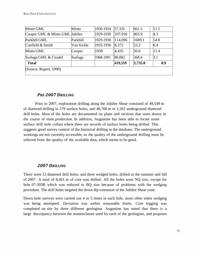
RED PINE EXPLORATION
Minto GML Minto 1930-1934 57,335 661.5 11.5 Cooper GML & Minto GML Jubilee 1929-1939 107,930 463.9 4.3 Parkhill GML Parkhill 1929-1938 114,096 1689.1 14.8 Canfield & Smith Van Sickle 1935-1936 8,372 53.2 6.4 Minto GML Cooper 1938 4,435 50.6 11.4 Surluga GML & Citadel
Surluga 1968-1991 86,082 268.4 3.1
Total 419,559 3,735.8 8.9 (Source: Rupert, 1990)
PRE 2007 DRILLING
Prior to 2007, exploration drilling along the Jubilee Shear consisted of 49,549 m of diamond drilling in 279 surface holes, and 48,768 m in 1,502 underground diamond drill holes. Most of the holes are documented on plans and sections that were drawn in the course of mine production. In addition, Augustine has been able to locate some surface drill hole collars where there are records of surface holes being drilled. This suggests good survey control of the historical drilling in the database. The underground workings are not currently accessible, so the quality of the underground drilling must be inferred from the quality of the available data, which seems to be good.
2007 DRILLING
There were 12 diamond drill holes, and three wedged holes, drilled in the summer and fall of 2007. A total of 8,401 m of core was drilled. All the holes were NQ size, except for hole 07-393B which was reduced to BQ size because of problems with the wedging procedure. The drill holes targeted the down dip extension of the Jubilee Shear zone.
Down hole surveys were carried out 4 or 5 times in each hole, more often when wedging was being attempted. Deviation was within reasonable limits. Core logging was completed on site by three different geologists. Augustine has noted that there is a large discrepancy between the nomenclature used by each of the geologists, and proposes
18

RED PINE EXPLORATION
to re-log and resample the core. A lack of storage space prompted Citabar to dispose of some of the core that was considered to be unmineralized.
2011 DRILLING
In the spring of 2011, Augustine conducted an 18 hole drill program to verify the historical data on the Surluga claims. Five of the holes were set to target the mineralization around the Citadel Jubilee mine, while the remaining 13 holes were designed to twin existing diamond drill holes. Discovery Diamond Drilling Ltd. of Morinville AB was contracted to drill 2,944m
of NQ size core. The holes were s urveyed every 10 m down the hole using a Flex-IT®
down hole survey tool. The drill hole collar locations were located with a SXBlue WAS Area based GPS survey instrument. The core was transported by Augustine personnel by truck to the core shack in Wawa, where it was logged and sampled.
7.0 Current Exploration: 2014 Diamond Drilling
The main focus of the 2014 winter drill program was to intersect high grade gold mineralization which was previously intersected in underground drilling during historic drill campaigns. As a secondary goal, this drilling also helped to confirm the location of underground workings which were in close proximity the planned program of drill holes.
Supported by Permit PR-13-10304, six (6) diamond drill holes, SD-14-01 to SD-14-06 (Table 2), comprising 1573 meters of diamond drilling were completed between December 2nd, 2014 and December 19th, 2014 on the Wawa Gold property. Diamond drill hole locations are shown on Figure 5.
Table 2: 2014 Hole Locations, Orientation and Claims where Work was Performed
Hole_ID X Y Start Date
End Date AZ Dip Depth Claim
Length (m)
SD-14-01 668306.4 5316786 2014/12/03 2014/12/04 317.5 -62 127 SSM59662 127 SD-14-02 668306.7 5316786 2014/12/04 2014/12/06 328 -65 231 SSM59662 231 SD-14-03 668441.6 5316567 2014/12/06 2014/12/09 340.1 -62 309 SSM3407 53.49
SSM59664 255.51
SD-14-04 668449.3 5316300 2014/12/09 2014/12/13 340 -65 330 SSM3104 20.93
SSM3407 309.07
SD-14-05 668364.9 5317013 2014/12/13 2014/12/15 234 -47 234 SSM59662 234 SD-14-06 668205.3 5315775 2014/12/15 2014/12/18 345 -45 342 SSM3132 96.4
SSM3131 245.6
Total Metres
1573
19

RED PINE EXPLORATION
Figure 5: Wawa Gold Project Property with Claims and 2014 Drilling Locations
20

RED PINE EXPLORATION
A large volume of geochemical and structural data was also collected on these 6 holes from the start of the drill program through to January 24th, 2015. The objective of this exercise was not only to provide an effective framework of data collection moving forward, but also to develop ideas and practices which would be reiterated back on the wealth of historic drill core and geological data which exists for the property. Utilization of the Reflex ACTIII tool to orient the core has been implemented throughout this drill program in order to obtain more detailed structural information from drill core.
DIAMOND DRILLING CONTRACTOR
Norex drilling was contracted out of porcupine (just west of Timmins) to come to camp and complete the drill program. The project is road accessible so the drill was able to be moved by skidding it behind a bulldozer. Norex utilized the Reflex ACT III tool to mark the bottom of the core for each run, producing oriented core for further analysis.
CORE HANDLING PROCEDURES
The core was boxed at the drill and labeled with the hole number and box number, as well as blocks within the core indicating the end of each drill run every 3 meters. At the end of this 3m interval a mark indicating the bottom of the core was drawn on the last piece at the drill. A lid was placed on the box, taped shut and transported by snowmobile and sleigh from the drill to the core logging facility (the core shack). The core shack is located within the town of Wawa, no more than 6km from any of the drill hole locations. After arrival in the core shack, the core boxes were opened and moved inside to defrost prior to logging.
CORE LOGGING
An extensive logging procedure was developed in order to acquire the most accurate and detailed information possible from the core. When the core is defrosted meter marks are promptly drawn on, referencing the block every three meters included by the drillers.
21

RED PINE EXPLORATION
STRUCTURE
The structural aspect of logging is the first to take place. It requires the entire core to be pieced together in order to obtain a continuous, or near continuous piece of core from the top of the hole to the bottom. A solid line is then drawn on the core connecting the marks made at the drill at the end of each run. This solid line represents the bottom of the core in the hole, proving a reference line to measure all structural data from. Structural aspects of interest are then marked on the core and measured relative to the previously mentioned line noting the bottom of core using the alpha-beta method. This method utilizes a transparent tube with angles relative to the long axis(alpha) and angles around the circumference of the core (beta).
XRF
The drill core was analyzed with an x-ray florescence (XRF) device in order to acquire real time geochemical data. A total of 2073 readings were obtained. Measurements were taken at a minimum of every meter for either 60 or 90 seconds depending on the suite of elements analyzed. The results were combined with a visual inspection of the core in order to achieve more accurate lithological descriptions and alteration suites even in cases where the protolith was indistinguishable.
GEOLOGY
The core was visually inspected and logged based on the field geologist’s descriptions. The information was then input into the Gemslogger software, an extension of Microsoft access. The incorporation of a variety of analytical methods was utilized in order to best describe lithological units. These included testing magnetism with a magnet, reactivity with 10 molar HCL and scratch testing with a nail to estimate hardness. All of these components were then used in order to create a lithological description of the core from the top to the bottom of the hole. This log is subdivided by lithologies with description of alteration, texture and mineral abundances included.
MAGNETIC SUSCEPTIBILITY
A KT-10 magnetic susceptibility meter was used to measure and record the magnetic susceptibility at 1 meter intervals along each of the drill cores. This provided us with quantitative data regarding the magnetism of the rocks down the length of each drill hole.
22

RED PINE EXPLORATION
CORE RECOVERY
Core recovery was very important to this program because of the orientation process. Since the core was pieced together into one continuous run, any missing core creates gaps of information. Extensive discussions with the drilling team verified that all efforts were made to see the highest possible core recovery rates. As such, a very high level of core recovery was achieved throughout the program.
CORE PHOTOGRAPHY
Photos were taken of all core drilled through this program. While the core was in the core shack on the logging tables, wet and dry photos of the core were taken after all marks and annotations were added.
COLLAR SURVEY
All drill collars were surveyed after completion of drilling using a handheld Garmin Oregon GPS. This unit reports an accuracy of ~5m with minimal tree cover and moderately clear skies. Future plans include utilizing a high accuracy GPS unit to more accurately locate all historic collars as well as provide accurate elevation data which can be confirmed with the preexisting digital elevation model (DEM).
SAMPLING AND ASSAYS
A total of 624 core samples along with 78 whole rock samples were sampled for assay analysis from the 6 holes drilled during this program. All of the samples were sent to Activation Laboratories’ (Act labs) facility in either Timmins or Ancaster for analysis. Samples were selected by the logging geologist and then core was cut in half and one half was sent to the lab. The other half remains in the core shack in Wawa as a reference. These samples were then placed in durable plastic bags with an identification tag, zip tied shut and grouped into large rice bags for transport. All samples were transported by Red Pine personnel to Act Labs for analysis in our company truck.
23
RED PINE EXPLORATION
Assay samples were selected to test gold mineralization within the jubilee shear zone which was believed to be the main control of gold mineralization on the deposit. Along with the main shear, any other shears intersected were also sampled in order to determine which structures are associated with gold mineralization. Areas with increased sulphide content and/or quartz veins were also sampled as several of the historic mines as well as historic surface showings were vein controlled gold mineralization.
The 1A2-UT4 analysis package with RX1 prep was utilized in order to assay for gold as well as a broad suite of other elements. In areas where higher grade mineralization was expected, 1A4-UT4 was utilized which incorporated a metallic screening process to aid in the reduction of nugget effect often seen in gold deposits of this type.
To accompany the drill core assay results, 78 whole rock samples were also collected in areas deemed less prospective for gold mineralization. These samples were analyzed in an attempt to gain better control over the main lithologies and alterations on the property. The analysis package for these samples was also the 1A2-UT4 with 4C added to include a more detailed chemical analysis. No 1A4 was utilized for whole rocks as they were not selected from prospective higher grade zones.
Reference material was systematically included in sequence for QA/QC of lab results. An Oreas Standard (Oreas 205, 206 or 209) was included every 20 samples and a 200g 'white lightning' blank was included every 25 samples.
DOWN HOLE SURVEYS
Several down hole surveys were performed in order to gain as much information possible from each drill hole. While drilling was being undertaken, a Reflex easy shot was used to provide in-hole azimuth and dip. This survey was completed ~10m below the bottom of the drill casing as well as every 50m below that. This device uses magnetism for its measurements so in areas where ferromagnetism is prevalent in the rocks, it should be noted that this measurement can be unreliable. The Reflex ACTIII is also used in conjunction with drilling in order to indicate the bottom of the drill core as it comes out of the hole.
The down-hole survey was an important aspect to drilling as holes typically flatten and bend to the right. This effectively decreases the dip and increases the azimuth. With underground workings in the area it is integral to ensure not only that the location of the collar is correct but also to effectively track the path of the drill hole as it progresses to target depth.
24

RED PINE EXPLORATION
8.0 Results The highlights from the 2014 drilling campaign are outlines below in Table 3. SD-14-01 intersected a drift from underground working and was terminated before reaching planned depth. The cause of this was due to that fact that the original azimuth of the drill setup was several degrees off planned. The resulting intersection of the drift emphasized the importance of highly accurate drill rig positioning and hole orientation.
Aside from the first hole, the mineralized intersections encountered in the following 5 holes were very promising and yielded significant intervals of gold mineralization. This mineralization predominantly lies within the Jubilee shear which has been described as a 20-50m wide shear zone dipping to the south east at 20-40 degrees.
Table 3: Drilling Highlights from 2014 Drill program Hole ID From (m) To (m) Length* (m) Gold (g/t)
SD-14-01** 75.5 78.1 2.6 2.61 SD-14-01 107.07 127 19.9 0.73
incl. 107.07 109.6 2.53 3.15 incl. 115.05 118.76 3.71 1.11
SD-14-02*** 80.5 82.5 2 3.85**
SD-14-02 118.25 128.38 10.1 3.16 incl. 119.5 126.5 7 4.44
SD-14-03 244.3 248.8 4.5 0.68 SD-14-03 244.3 275.08 30.78 3.06
incl. 255 258 3 4.45 incl. 264.1 271.8 7.7 8.89
SD-14-04 248.86 297.52 48.66 4.41
incl. 260.75 277.35 16.6 11.13
SD-14-05 134.86 165.5 30.64 3.38 incl. 155 162.5 7.25 12.94
SD-14-06 10.61 22.72 12.11 1.67 SD-14-06 294.83 322.5 27.67 2.89
incl. 301.1 304.4 3.3 6.52 incl. 318.5 322.5 4 11.54
25

RED PINE EXPLORATION
While the drilling during this program was designed to target zones within the current NI-43-101 resource, the specific zones targeted were drilled from underground workings and this data was not incorporated into the resource model. This was due to that fact that resampling of historic core was never completed to check assay results and no surface drill holes were planned previously to intersect these zones. As such, drilling from surface in these locations has confirmed the location of the underground workings as well as provided an increase in confidence that the higher grade mineralization does exist.
Along with the assay results from drilling, a large volume of data on rock chemistry and magnetism was collected from the drill cores. Through the use of x-ray florescence (XRF) analyzers and the KT-10 magnetic susceptibility tool on site geologists were able to recognize complicated lithologies and alterations. The analysis of this data will aid in further drill targeting as well as provide a more detailed chemical composition of the different rock types encountered in this drill program to date.
9.0 Conclusions and Recommendations The drilling was successful at confirming the location of underground workings as well as testing higher grade zones of mineralization within the Surluga mine area. Drill targets were in close proximity to historic workings and with the exception of SD-14-01, no workings were intersected. This was expected as Hole 1 was slightly off planned azimuth and after the initial downhole survey it was believed a drift would be intersected. The hole was completed with this in mind to confirm the drift location as well as test for gold mineralization proximal to such historic workings.
The remaining 5 holes were successful at intersecting positive gold mineralization. These results show that the broad and locally higher grade gold mineralization does exist within the Surluga deposit.
Moving forward, it is recommended that further drilling be completed within the jubilee shear in areas where gold mineralization is currently thin or pinched out. By filling in these gaps, a more continuous and thicker mineralized shear should be attainable. Along with this, several mineralized intervals in the hanging wall were intersected. It is recommended that these zones of hanging wall mineralization be tested and delineated. As well as infilling gaps within the current extents of the shear zone, it is also suggested that several drill holes be places in the surrounding areas of the shear to confirm and expand the along strike extensions of this zone.
It is also recommended that thin section petrography be used to further develop the lithological model. In addition, the XRF and Magnetic Susceptibility should continue to be utilized in order to develop a more statistically robust data set through the entirety of the deposit area. Initial observations include a chemical ratio which highlights gold bearing zones within the shear zone as well as demagnetization of the shear zones. As a more robust data set is developed through
26

RED PINE EXPLORATION
reanalysis of historic core and further drilling, more data analysis can be completed to further the initial observations made during this program.
10.0 Statement of Qualifications
I, Quentin Dale Yarie, P. Geo. of 196 McAllister Road, Toronto, Ontario, M3H 2N9, do hereby
certify that:
• I am a member of the Association of Professional Geoscientists of Ontario since 2010 (License 1778) and a member of the Association of Professional Geoscientists of Nova Scotia since 2002 (License 121). I am also a member of the Society of Exploration Geophysicists (144385).
• I have practiced my profession in excess of 25 years • I certify that by reason of my education and past relevant work experience, I fulfill with the requirements to
be a “Qualified Person“ for the purpose of this Assessment Report. My relevant work experience for the purpose of my activities identified in this report are:
• Experience with junior resource companies as a Director of Red Pine Resources (CNDX) and Red Pine Exploration (CNDX). Experience with junior resource companies as Vice President of Exploration of Red Pine Exploration Ltd., Red Pine Exploration Ltd., and Honey Badger Exploration Inc.
• Continuous work in the mineral exploration and mining industry since 1983. I ran my own geophysical consulting firm from 1990 through 2002. Work has included supervision of grassroots to advanced stage programs which have included airborne and ground geophysics, mapping, geochemical sampling, trenching and drilling. I have reviewed numerous gold, silver, base metals and diamond projects in a wide range of geological environments both in Canada, Mexico, Chile, China, Turkey, Jordan, Italy, and other international destinations.
• I am the author of several Technical Reports.
Dated at Toronto, Ontario, this 15th day of March, 2015
Quentin D. Yarie, P. Geo. (ON), P. Geo. (NS)
27

RED PINE EXPLORATION
I, Blake James McLaughlin of 2-54 Glovers Rd, Oshawa Ontario, Canada, do hereby certify that:
• I have completed an Honors Bachelor of Science degree in Geoscience from McMaster University in Hamilton Ontario.
• I have practiced my profession for five and a half years
• I spent 3 years operating and overseeing field operations for Insight Geophysics, completing geophysical surveys for exploration and mining companies
• I spent the 2.5 years working as a consulting geologist, involving prospecting and diamond drilling programs in a variety of locations within Canada
• I am currently employed as a staff geologist involved in a variety of aspects of mining exploration including reporting, field operations and administrative duties
Dated at Toronto, Ontario, this 15thday of March, 2015
Blake J McLaughlin, BSc. Geoscience (Hons)
28

RED PINE EXPLORATION
11.0 References
Bowdidge, C.R., 1996 Gold Mineralization in the Jubilee Shear Zone, Re-appraisal as a Large- Tonnage, Low-Grade Bulk-Mineable Underground Resource.
MacMillen, D. and Rupert, R.J., 1990 Geological Mapping in the vicinity of the Grace-Darwin, Parkhill and Minto mines.
Sherman, B., 2005, Illustrated Information to Accompany an Independent Assessment of the Mineral Exploration Potential of the Surluga Property of Citadel Gold Mines Inc., at Wawa, Ontario: Report for Citadel Gold Mines Inc., 48 p.
Frey, E.D., 1987, Geology of Wawa area gold mineralization: Institute of Lake Superior Geology Field Trip Guidebook, v. 33, Part 2, 31 p.
Frohberg, M.H., 1935, The Ore Deposits of the Michipicoten Area: 44th Annual Report of the Ontario Department of Mines, Vol. 44, Part 3, p. 39–83.
Helmstaedt, H., 1988, Structural observations in the Surluga and Jubilee mines, Citadel Gold Mines Inc., Wawa, Ontario: Report for Citadel Gold Mines Inc., 29 p.
Kuryliw, C.J., 1970, Progress report on Surluga Gold Mines Ltd.: Ontario Ministry of Northern Development and Mines Assessment Report No. 41N15NE00036, 13–19 p.
Polat, A. and Kerrich, R., 2000, Archean greenstone belt magmatism and the continental growth-mantle evolution connection: constraints from Th-U-Nb-LREE systematics of the 2.7 Ga Wawa subprovince, Superior Province, Canada: Earth and Planetary Science Letters, v. 175, p. 41-54.
Rupert, R.J., 1997, Exploration report on the Wawa area properties of Citadel Gold Mines Inc., Report for Citadel Gold Mines Inc., 51.
Sage, R.P., 1994, Geology of the Michipicoten greenstone belt: Ontario Geological Survey Open File Report 5888, 592 p.
29

RED PINE EXPLORATION
12.0 Appendices (attached as separate files)
ASSAYS AND CERTIFICATES
CORE LOGS
DRILL SURVEY
SECTIONS
LITHO KEY
XRF READINGS
MAGNETIC SUSCEPTIBILITY READINGS
CORE PHOTOS
30