REPORT OF THE MASTER PLAN OF ARCHAEOLOGICAL RESOURCES …
125
REPORT OF THE MASTER PLAN OF ARCHAEOLOGICAL RESOURCES OF THE DISTRICT MUNICIPALIlY OF MUSKOKA AND THE WAHTA MOHAWKS VOLUME 2 TRADmONAL USE STUDY AND ARCHAEOLOGICAL SURVEY ."~. rr~ ' .. ,. f ' 20 em ope Petroglyph Site (BeGu-4) o seale Submitted to THE DISTRICT MUNICIPALI1Y OF MUSKOKA and THE WAHTA MOHAWKS ARCHAEOLOGICAL SERVICES INC. February 1994
Transcript of REPORT OF THE MASTER PLAN OF ARCHAEOLOGICAL RESOURCES …

REPORT OF THE MASTER PLAN OF ARCHAEOLOGICAL RESOURCESOF THE
DISTRICT MUNICIPALIlY OF MUSKOKAAND THE WAHTA MOHAWKS
VOLUME 2TRADmONAL USE STUDY AND ARCHAEOLOGICAL SURVEY
."~.
rr~' ..,.
f '
20 em
ope Petroglyph Site (BeGu-4)
o seale
Submitted toTHE DISTRICT MUNICIPALI1Y OF MUSKOKA
andTHE WAHTA MOHAWKS
ARCHAEOLOGICAL SERVICES INC.
February 1994

REPORT OF THEMASTER PLAN OF ARCHAEOLOGICAL RESOURCES
OF THEDISTRICT MUNICIPALITY OF MUSKOKA
AND THE WAHTA MOHAWKS
VOLUME 2TRADITIONAL-USE STUDY AND ARCHAEOLOGICAL SURVEY
Submitted toTHE DISTRICT MUNICIPALITY OF MUSKOKA
andTHE WAHTA MOHAWKS
ARCHAEOLOGICAL SERVICES INC.662 Bathurst StreetTownto, Ontario
M5S 2R3
in association with
Untennan McPhail Cuming AssociatesMount McGovern Co., Ltd.
Dr. Carole CarpenterMs. Susan L. Maltby, Conservator
February 1994

Page i
Project Personnel
Project Director: Dr. Ronald F. Williamson
Project Archaeologists: Mr. Martin S. CooperMr. Robert 1. MacDonald
Field Archaeologists: Dr. Chen ChunMs. Jane Cottrill
Dr. Andrew StewartMr. Robert von Bitter
Lithic Analyst: Dr. Chen Chun
Faunal Analyst: Ms. Deborah Pihl
Report Preparation: Mr. Martin S. CooperMr. Robert 1. MacDonald
Report Editing: Mr. Robert 1. MacDonaldMr. D.A. Robertson
Production and Graphics: Mr. Martin S. CooperMs. Jane Cottrill
Mr. Robert 1. MacDonaldMs. Deborah Pih)Ms. Nancy Traut
Photography: Ms. Jane CottrillMr. Robert MacDonald
Archaeological Services Inc.

Page ii Master Plan of Heritage Resources for theDistrict Municipality of Muskoka and the Wahta Mohawks
Acknowledgements
Logistical and financial support for this master plan study was provided by the DistrictMunicipality of Muskoka and the Muskoka Heritage Foundation, through the MuskokaHeritage Areas Program, the Wahta Mohawks, the Lake of Bays Heritage Foundation, theMinistry of Natural Resources and the Ministry of Culture, Tourism and Recreation.
With respect to the traditional use and archaeological survey components of the master plan,Archaeological Services Inc. wishes to take this opportunity to restate our sincere thanks forthe assistance and warm hospitality extended by so many Muskoka residents as well as theirenthusiastic endorsement of this study. In particular, we thank Ms. Judi Brouse, Directorof Long Range Planning, and the staff of the District Municipality of Muskoka, whoprovided invaluable logistical support and guidance. In addition, we wish to acknowledgethe assistance of the following individuals who contributed their valuable time and knowledgeto the research for this volume. .
• Ms. Susan Allen, Muskoka Lakes Museum• Ms. Pat Barr, Bracebridge Public Library• Mr. Ross Boothby, Point Ideal• Mrs. Linda Brett, Milford Bay
Mr. Neil and Mrs. Sybil Brodie, High Falls Chalet Inn, Bracebridge• Mr. Tim and Mrs. Donna Brodie, High Falls Chalet Inn, Bracebridge• Ms. Betty Campbell, Baysville• Mr. Peter Campbell, Campbell's Landing
Mr. Jeff Castell as, District Municipality of MuskokaMr. Clark, Morrison Township
• Ms. Sara Clipsham, Sparrow LakeMr. Cowan, Bracebridge
• Mr. Stan and Mrs. Jean Clipsham, Sparrow LakeMr. and Mrs. Cottrill, HuntsvilleMs. Christine Dodd, Ministry of Transportation, amarioMr. Donnelly, Sparrow LakeMs. Bernice Field, Ministry of Culture, Tourism and Recreation
• Ms. Elene Freer, Woodchester Villa, BracebridgeMr. George Gray, Shanty BayMr. Peter Goering, Lake of Bays _Mr. Don Gordon, Muskoka Heritage Foundation, BracebridgeMessrs. Bastian and Robert Groenevelt, Fraserburg
Archaeological Services Inc

Page iii
• Ms. Lindsay Hill, Director, Muskoka Lakes Museum• Ms. Roma Hopkins, Muskoka Lakes Museum
Mr. Ted Hungerford and Family, LuminaMr. Jamie Hunter, Huronia MuseumMr. Jack Hutton, BalaMr. Lome and Mrs. Bunty Jewitt, Bala
• Mr. Bill Kelly, Tooke Lake• Mr. Thomas Knight, Brackenrig• Mr. Kim Lambert and Ms. Nadya Tarasoff, Menominee Lake
Mr. Paul Lennox, Ministry of Transponation, OlZtan'o• Mr. Mike Lynch, A"owlzead Provincial Park, MNR
Mr. Craig Macdonald, Algonquin Provincial ParkMs. Nancy McFadden, Muskoka Lakes MuseumMr. Mark and Mrs. Judy McLean, Point IdealMr. Ken McPhee, BaysvilleMs. Roberta O'Brien, Ministry of Culture, Tourism and Recreation
• Ms, Cynthia Pope-Bruce, Sparrow LakeMr. Stephen and Mrs. Diana Silverthorn, Muldrew Lake
• Mr. Victor Smith, BarlochanMs. Nancy Summerley, Bracebridge Public LibraryMr. Wib White, BracebridgeProf. Joan Vastokas, Trent University
Archaeological Services Inc.

Master Plan of Heritage Resources for theDistrict Municipality of Muskoka and the Wahta Mohawks
Page iv
Table of Contents
Project Personnel .
Acknowledgements . . . . . . . . . . . . . . . . . . . . . . . . . . . . . . . . . . . . . . . . . . . . . . . . .. 11
Table of Contents. . . . . . . . . . . . . . . . . . . . . . . . . . . . . . . . . . . . . . . . . . . . . . . . . .. IV
List of Figures . . . . . . . . . . . . . . . . . . . . . . . . . . . . . . . . . . . . . . . . . . . . . . . . . . . .. vi
List of Tables . . . . . . . . . . . . . . . . . . . . . . . . . . . . . . . . . . . . . . . . . . . . . . . . . . . . .. V11
List of Plates viii
1 ANISHINABEK TRADITIONAL-USE SITES AND ORAL HISTORYby M. S. Cooper 1
1.1 INTRODUCTION 11.2 ABORIGINAL HISTORY OF MUSKOKA 21.3 ANISHINABEK TRADITIONAL USE SITES AND ORAL HISTORY . . .. 8
1.3.1 Settlements . . . . . . . . . . . . . . . . . . . . . . . . . . . . . . . . . . . . . . . .. 91.3.2 Sugar Bush . . . . . . . . . . . . . . . . . . . . . . . . . . . . . . . . . . . . . . .. 111.3.3 Berry Collecting 111.3.4 Bark Collecting . . . . . . . . . . . . . . . . . . . . . . . . . . . . . . . . . . . .. 121.3.5 Farming 121.3.6 Fishing 131.3.7 Hunting 141.3.8 Travel . . . . . . . . . . . . . . . . . . . . . . . . . . . . . . . . . . . . . . . . . . .. 151.3.9 Cemeteries 161.3.10 Natural Landscape Features 17
2 ARCHAEOLOGICAL SURVEY: REFINEMENT OF PREHISTORICARCHAEOLOGICAL SITE POTENTIAL MODEL
by R.I. MacDonald . . . . . . . . . . . . . . . . . . . . . . . . . . . . . . . . . . .. 292.1 INTRODUCTION 292.2 RESEARCH DESIGN 292.3 FIELDWORK RESULTS 31
2.3.1' Survey Area 1 . Sparrow and Morrison Lakes 31
Archaeological Services Inc

Page v
2.3.2 Survey Area 2 • Lake Muskoka 432.3.3 Survey Area 3 • Lakes Joseph and Rosseau 482.3.4 Survey Area 4 • Three Mile Lake. . . . . . . . . . . . . . . . . . . . . . .. 532.3.5 Survey Area 5 • Muskoka River . . . . . . . . . . . . . . . . . . . . . . . .. 542.3.6 Survey Area 6 • Big East River and Huntsville Lakes 632.3.7 Survey Area 7 • Lake Algonquin Strand . . . . . . . . . . . . . . . . . .. 662.3.8 Survey Area 8· Lake or Bays. . . . . . . . . . . . . . . . . . . . . . . . . .. 67
3 SUMMARY AND CONCLUSIONSbyRl MacDonald . . . .. 97
REFERENCES CITED 105
Appendix 1 • Artifact Catalogue . . . . . . . . . .. 107
Archaeological Senlices lnc

Page vi Master Plan of Heritage Resources for theDistrict Municipality of Muskolw and the Wahta Mohawks
List of FiguresFigure 1: Traditional-use Sites/Areas--NTS Map 31 0113 • • • . . • • . • • . . . • . • . . . . . . . . . . .. 18Figure 2: Traditional-use Sites/Areas--NTS Map 31 E/4 19Figure 3: Traditional-use Sites/Areas--NTS Map 31 E/6 ..•......................... 20Figure 4: Traditional-use Sites/Areas--NTS Map 31 E/6 cont'd 21Figure 5: Traditional-use Sites/Areas--NTS Map 31 E/3 ••.......................... 22Figure 6: Traditional-use Sites/Areas--NTS Map 31 0/14 . . . . . . . . . • . . . . . . . . . . . . . . . . .. 23Figure 7: Traditional-use Sites/Areas--NTS Map 31 EI9 .••.•.•..................... 24Figure 8: Traditional-use Sites/Areas--NTS Map 31 E/4 cont'd 25Figure 9: Traditional-use Sites/Areas--NTS Map 31 E/6 cont'd 26Figure 10: Traditional-use Sites/Areas--NTS Map 31 E/6 cont'd 27Figure 11: Pope Petroglyph Site (BeGu-4) . . . . . . . . . . . . . . . . . . . . . . . . . . . . . . . . . . . .. 39Figure 12: Line Drawing of Clipsham Photograph - Possible Petroglyph SHe 40Figure 13: Survey Units la, 1b, Ie (shaded). 1:10,000 scale. . . . . . . . . . . . . . . . . . . . . . . . . .. 74Figure 14: Survey Units 1d (shaded). 1:10,000 scale. 75Figure 15: Survey Unit Ie (shaded at arrow). 1:50,000 scale. 76Figure 16: Survey Unit If (shaded). 1:10,000 scale. 77Figure 17: Survey Unit 19 (shaded). 1:10,000 scale. . . . . . . . . . . . . . . . • . . . . . . . . . . . . . .. 78Figure 18: Survey Unit 1h (shaded). 1:10,000 scale. . . . . • . . . . . . . . . . . . . . . . . . . . . . . . .. 79Figure 19: Survey Units Ii (broken line) and 2e (shaded at arrows). 1:50,000 scale. 80Figure 20: Survey Unit 2a (shaded and dashed line). 1:50,000 scale. . . . . . . . . . . . . . . . . . . . .. 81Figure 21: Survey Unit 2b (shaded at arrows). 1:50,000 scale. 82Figure 22: Survey Units 3a, 3b, 3e, 3d, 4b (dashed line and shaded). 1:50,000 scale. . . . . . . . . . .. 83Figure 23: Survey Unit 4a (dashed line). 1:10,000 scale. 84Figure 24: Survey Units Sa, 5b, & 5e (shaded). 1:11,000 scale (approx.). . . . . . . . . . . . . . . . . .. 85Figure 25: Survey Units 5e & 5d (dashed line). 1:50,000 scale. . . . . . . . . . . . . . . . . . . . . . . .. 86Figure 26: Survey Unit Sf (shaded). 1:10,000 scale. 87Figure 27: Survey Units 5g & 5h (dashed lines and shaded). 1:50,000 scale., . . . . . . . . . . . . . . .. 88Figure 28: Survey Units 5i, 5j & 6a (dashed lines). 1:50,000 scale. 89Figure 29: Survey Unit 6b (dashed line). 1:50,000 scale. .. . . . . . . . . . . . . . . . . . . . . . . . . .. 90Figure 30: Survey Unit 6c (dashed line). 1:50,000 scale. 91Figure 31: Survey Units 7a & 7b (shaded). 1:50,000 scale. . . . . . . . . . . . . . . . . . . . . . . . . . .. 92Figure 32: Survey Unit Sa (shaded at arrow). 1:50,000 scale. 93Figure 33: Survey Unit 8b (shaded). 1:10,000 scale. . . . . . . . . . . . . . . . . . . . . . . . . . . . . . .. 94Figure 34: Survey Unit 8c (shaded). 1:10,000 scale. . . . . . . . . . . . . . . . . . . . . . . . . . . . . . .. 95Figure 35: Survey Unit 3d & Be (shaded). 1:10,000 scale. 96
Archaeological Sen'ices Inc

Page vii
List of TablesTable 1: Muskoka: Traditional Use Chronology 3Table 2: Aboriginal Place Names Related to Muskoka 6Table 3: Summary of Muskoka Survey Results--New Sites Registered 102
Archaeological Services Inc.

Page viii Master Plan of Heritage Resources for theDistrict Municipality of Muskoka and the Wahta Mohawks
List of Plates
Plate 1: Groundstone Gouge - Stan Clipsham (BeGu-2) 34Plate 2: Sara Clipsham Collection (BeGu-3) 34Plate 3: Sara Clipsham Collection (BeGu-3), continued. . . . . . . . . . . . . . . . . . . . .. 35Plate 4: Pope Petroglyph Site (BeGu-4) 35Plate 5: Renshaw Site (BgGw-3) Assemblage 47Plate 6: Projectile Point from Jewitt Site (BgGw-5) . . . . . . . . . . . . . . . . . . . . . . . .. 47Plate 7: Hungerford Collection: Turner's Island site (BhGr-5) [j]; Hungerford site
(BhGr-6) [b,c,e]; Norway Point site (BhGs-8) [h]. 73Plate 8: Seventeenth Century Iron Trade Axe--Raynor Island site (BhGr-7) . . . . . .. 73
Archaeological Services Inc.

1 ANISHINABEK TRADITIONAL-USE SITES AND ORAL HISTORYby M. S. Cooper
1.1 INTRODUCTION
The major objective of this study is to produce, through documentary research and thecollection of oral histories from tribal elders, an inventory of traditional-use sites which canbe located on the available mapping and which recognizes the continuation of Anishinabekheritage and land use in the study area. In this fashion, a set of cultural data, specific tosites used by the local Anishinabek, will be available for consideration during the finalplanning phase of the Master Plan. Furthermore, the collection of such ethnohistoric datawill allow for a generalized reconstruction of seasonal activities which, in turn, may be usedto help refine the predictive model of archaeological site potential presented in Volume 1.
Two major cultural groups must be distinguished when investigating the traditional use ofthe Muskoka District: the Anishinabek (Ojibwa) and the Wahta Mohawks (formerlyMohawks of Gibson River). This distinction is necessary since the two occupations differgreatly due to temporal and cultural factors. Anishinabek use of Muskoka took place, forthe most part, prior to 1880,while the Wahta Mohawk use of the area commenced after thatdate and has continued to the present. Linguistic and cultural difference are alsoconsiderable, the Anishinabek being Algonquian speakers, whereas the Wahta Mohawks areIroquoian speakers. Moreover, while the Anishinabek occupation was extensive, takingplace over most of the district, Mohawk use has been intensive, concentrating on Wahta andthe surrounding townships. Accordingly, the traditional-use information will be presentedin two separate sections. The first section, which deals with nineteenth-century traditionaluses and is therefore most pertinent to considerations of archaeological potential, ispresented below. The second section, which deals with the traditional use of Muskoka bythe Wahta Mohawks, is currently being compiled and will be submitted as a separateaddendum.
By the turn of the nineteenth century, Anishinabek families were bunting, fishing. farming,and trapping throughout Muskoka. Historical documents combined with oral traditionprovide the data for identifying areas of traditional use. In order to compile the relevantdata, a number of individuals who are currently conducting research related to the traditionalnative use of Muskoka were contacted. Mr. Craig Macdonald, who has been conductingresearch into traditional travel routes throughout the Canadian Shield, provided informationfor the eastern portion of Muskoka. Most of these data were derived from interviews hehas conducted with long-time Muskoka residents who recalled events and stories regardingthe area's original inhabitants. Mr. Peter Goering of the Lake of Bays ResidenceAssociation provided background information on the Lake of Bays area, in particular, BigwinIsland. Mr. Franz Koennecke, treaty researcher for the Georgian Bay/Lake Nipissing TreatyUnit, provided information about the use of that portion of the District formerly occupied
ArchaeolOgical Services Inc.
Page 2 Master Plan of Heritage Resources for theDistrict Municipality of Muskolw and the Wahta Mohawks
by members of the Muskoka band, particularly in the area of the former Obagawanungsettlement (present day Port Carling). The descendants of the people who lived atObagawanung are members of the Parry Island First Nation. Dr. Ian Johnson, treatyresearcher for the United Indian Councils, provided information on member First Nationsthat used the Muskoka District during the nineteenth century. These groups include theMississaugas of Alderville, the Chippewas of Beausoleil, the Chippewas of Rama, and thePottawatomies of Moose Deer Point. Researchers with the United Indian Councils havemapped, using geographic information system (GIS) technology, nineteenth-century familyhunting territories in Muskoka. This geographical information was derived from deputationsmade for the 1923 Williams Treaty, and interviews with elders conducted between 1988 and1992. Sue and Harvey Anderson, historical researchers at M'ngikaning (formerly Chippewasof Rama First Nation) provided information regarding nineteenth-century traditional use.
In addition to the above contacts, documentary sources were consulted. Source material thatcontained relevant information includes: Florence Murray's (1963) compilation of documentsrelated to the early history of Muskoka and Haliburton Districts; Franz Koennecke's M.A.thesis (1984), which provided important information based on primary archival sources andoral histories; and deputations made by John Bigwin for the 1923 Williams Treaty.
Unlike other areas of aboriginal settlement such as Temagami and Manitoulin Island, themajority of families who lived in Muskoka no longer do so. Indeed, the extensive use ofMuskoka by Anishinabek families had diminished by the close of the nineteenth century.While oral traditions persist, despite the rapid passing away of elders, specific informationabout locations within Muskoka is limited.
1.2 ABORIGINAL HISTORY OF MUSKOKA
A chronology of historical events related to aboriginal traditional use has been presented inTable 1. By the late eighteenth century several Anishinabek bands lived year round orhunted on a seasonal basis in Muskoka. Western Muskoka was occupied by familiesaffiliated with the Muskoka band, whose members had been part of the Sandy Island andBeausoleil bands. Led by Chief John Aisance, who had arrived on Beausoleil Island in 1842from the Coldwater settlement, these people later moved to Christian Island in 1856 (Figure1). The southern and eastern portions of Muskoka were being used, primarily on a seasonalbasis, by M'ngikaning (Rama) families, such as the Yellowheads and Bigwins, who lived inthe vicinity of the Lake Couchiching Narrows. In the 1830s these families settled at Ramabut continued to travel on a seasonal basis to Muskoka.
Archaeological Services Inc.

Anishinabek Traditional-use Sites and Oral History Page 3
Table 1: Muskoka: Traditional Use Chronology
I DATE I HISTORICAL EVENT I1778 George Cowan (Jean Baptiste Constant) establishes trading house at Matchedash Bay
1793 John Simcoe meets Indians at the mouth of the Severn River
Lake Simcoe Band living at Couchiching Narrows
1794 Alexander Henry meets Matchedash Indians on the Severn River
Mesquakie (William Yellowhead) and 140 of his band visit posts at York and Niagara to
voice their complaints
1795 surrender of lands around Penetanguishene
1798 formal treaty signed
1800 Quetton St. George establishes fur post at Couchiching Narrows
1812 Mesquakie, Bigwind, Mesquido participate in War of 1812
1815 Treaty surrendering parts of Simcoe County
1816 Jean Baptiste Sylvestre establishes post at Sylvestre's Lake, Parry Sound, to trade with theIndians of the Muskokas
181? William Robinson works out of Newmarket and operates trading house southwest ofBracebridge, near the mouth of the Muskoka River and on Yoho Island in Lake Joseph
Alexander Bailey of Penetanguishene establishes trading post at Kekapekong(Bracebridge); abandoned by 1835
1818 treaty
1830 Coldwater model settlement established and reserves set aside for bands
Matchedash band settles at Coldwater
1831 part of Muskoka band settles on island in Lake Rosseau
1835 surveyors Carthew and Baddely meet Muskoka band, under Pamosagai. who had cleared 40acres on Tobin Island in Lake Rosseau
1836 Matchedash band living on Georgian Bay Islands from 1838 to 1842
William Yellowhead and Lake Simcoe band purchase 1600 acres on east shore of LakeCouchiching
Archaeological Services Inc.

Master Plan of Heritage Resources for theDistrict Municipality of Muskoka and the Wahta Mohawks
Page 4
Table 1: Muskoka: Traditional Use Chronology
I DATE I HISTORICAL EVENT I1837 David Thompson observes Indian lodges on an island in Lake Muskoka (Eilean Gowan
Island)
1838 temporary camp established for Indians at Holland Landing
1839 Yellowhead and Lake Simcoe band settles at Rama
1842 John Aisance and Matchedash band move to Beausoleil Island and use surrounding islandsfor growing crops
1845 John Bigwin born at Rama
1849 Anderson and Vidal Commission confers with 16 chiefs, who were willing to make landsurrenders, and maps territories of some Lake Huron Bands
1850 Robinson Treaty (61) signed; Meshoquetto (William King), son of Mesquedo, of Muskokaband signs treaty
1853 Alexander Murray mentions that the Indians of Lake Rosseau were trapping beaver in thearea north of Fairy and Peninsula Lakes
1857 Aisance and Beausoleil band move to Christian Island
1858 death of Megis, succeeded by Pegahmegabow as chief of Muskoka band
1860s trading took place at Auby's (Aunty's) Point on Lake of Bays, the families returning totheir camps at the north bay of Paint Lake, Hollow Lake, or the Ox Tongue Narrows(Dorset)
Other families hunting around Lake of Bays included: George; Joe; Yellowhead, Elijah,Peter and Samson; Norsnake, George and Noah; Quinbush
1860 Menominee, his wife, and two daughters mentioned by Wadsworth who had seen them onthe portage from South Bay into the main Muskoka Lake. He also stated thatMenominee's permanent camp was on Mary Lake
Archaeological Services lnc

Anishinabek Traditional-use Sites and Oral History Page 5
Table 1: Muskoka: Traditional Use Chronology
I DATE I HISTORICAL EVENT I1862 Tourists James Bain and John Campbell indicate that James Pegahmegabow Sr. (Chief of
Parry Island) was living on Peggy Island in Lake Joseph (just north of Muskoka boundary)
George Rykert, while surveying Ridout Township mentions that area was favourite huntingground of Lake Simcoe Indians, who also made large quantities of sugar there
Robert T. Burns reports that in McLean Township a few acres had been cleared for cornand potatoes
J.P. Varisttant reports that Brunei Township was highly valued as a hunting ground andthat 2 or 3 families camp there every fall and winter
1863 death of James Bigwin
1864 1864 death of William Yellowhead
1870 Obagawanung abandoned, renamed Port Carling
1871 Menominee's farm located at Menominee Lake
1881 Wahta (Gibson River Reserve) established by Mohawks
1911 John Bigwin deputation:-maintained regular camping grounds at Cedar Narrows;-raised corn, potatoes, and pumpkins in a clearing where the town of Dorset now stands-regular burial ground on Bigwin Island-made 5 day trip from Rama to· Trading Lake for 45 successive years taking route fromSevern River to Sparrow Lake, portage to Leg Lake, portage to Muskoka Lake, to theMuskoka River, to Bracebridge portage, to South Branch Muskoka River, to Trading Lake(Lake of Bays)
1917 Moose Deer Point Reserve established
1923 Williams Treaty
John Bigwin deputation:-he continued to travel to hunting grounds to gather birchbark for canoes and hunt-they maintained a clearing at Dorset where they grew potatoes and corn-elaborates on route from Rama to Trading Lake: First portage is Washa~o-down theSevern to Sparrow Lake, to Morrison Lake, to Leg Lake, portage to Muskoka Lake, toSouth Branch Muskoka River, portage at South Falls, then Tratheway's falls, thenMathew's falls
1940 death of John Bigwin
Archaeological Services inc,

Page 6 Master Plan of Heritage Resources for theDistrict Municipality of Muskoka and the Wahta Mohawks
Chief William Yellowhead's Anishinabek name "Mesquakie" was the basis for the wordMuskoka, which was used by early fur traders to refer to the Muskoka River and was firstmentioned by Alexander Shirref in 1829. Later, in the nineteenth century, Ojibwa familiesliving on the Indian (Biasong) River, were referred to as the Muskoka band, not because ofany connection with Mesquakie, but because of their geographical location. A translationof additional aboriginal place names is presented in Table 2.
By 1835, it is believed that Chief Pamosagai and several families of the Muskoka band hadsettled on Tobin Island in Lake Rosseau (Figure 2), where they had cleared 40 acres forgrowing corn and potatoes (see discussion in Sections 3.3.3.1 and 3.3.3.2). The band appearsto have moved to Obagawanung on the Biasong River around 1860, the site of present dayPort Carling (Murray 1963: 124). They remained there until 1868 when, due to theencroachment of Euro-Canadian settlement, they were compelled to move to Parry Island.
Muskoka band families also settled, hunted, and farmed in contiguous areas of Muskoka.James Pegahmagabow, who was chief of the Muskoka band after 1858, established hissettlement on Peggy Island in Lake Joseph (Obwadgwajung), an area that comprised at leasta portion of his hunting territory (Koennecke 1984:336).
Table 2: Aboriginal Place Names Related to Muskoka
Place Name TranslationlReference Location
Biasong River "at the place of the thunder and lightning" Indian River(Port Carling)(Fig 2)
Bigwind Lake named for Bigwin family (from Kitchay- Oakley TownshipBigwin Island [big] nodin [wind)) Lake of Bays (Fig 3)
Kehkapekon from Kek-kabikong, "at the place of the Bracebridge Portage (Fig 5)waterfall"
Kitshisagan from Kitchay-sawgeen. "at the mouth of Lake Muskoka (Fig 5)the large river"
Menominee Lake named for member of Muskoka band - McLean Twp (Fig 3) LakeMenominee Point means "wild rice" Vernon
M'ngikaning from Michigan-ning, "at the place of the Chippewas of Ramafish fence" (weir)
Moonz-o-zeebi "Moose River" Moon River (Fig 8)
Archaeological Services Inc.

Anishinabek Traditional-use Sites and Oral History Page 7
Table 2: Aboriginal Place Names Related to Muskoka
Place Name TranslationJReference Location
Musquash Zeebi "Muskrat River" Musquash River(Fig 8)
Nongetahwegahmog Lake-of-Bays, Trading Lake(Fig 4)
Obagawanung "at the place of the pot-like [deep-sided] Muskoka band settlement atnarrows" Port Carling (Fig 2)
Obwadgwajung Lake Joseph (Fig 2)
Paukuh "at the lake of the flying skeleton" Skeleton LakeSawgihayguning (Figs 9 and 10)
Wahta "maple" Mohawks of Gibson River
Wasoksing "at the place of the shining wood" Parry Island
Waswanay Island Beausoleil band member - means "torch- Island in Lake Rosseaulight fishing"
The Menominee family was well known to early settlers and surveyors during the middle-to late-nineteenth century. Menominee and his family lived and hunted in the area borderedby Lake of Bays (Nongetahwegahmog) in the east, Mary Lake in the west, and Lake Vernonto Peninsula Lake in the north. Menominee's settlement was located, during the 1860s, onMary Lake. Some years later he established a farm on Menominee Lake, just southwest ofLake of Bays (Figure 3). Menominee grew corn and potatoes and also kept livestock. Bythe early 1870s the Menominee family left their territory and settled with the rest of theMuskoka band on Parry Island. The area north of Fairy and Peninsula Lakes was used byLake Rosseau families to hunt Beaver (Murray 1963) (Figure 4).
After leaving the Coldwater settlement, the Beausoleil Band settled on Beausoleil Island in1842 (Figure 1). By 1846 the settlement at Cedar Springs contained 20 log houses, a barn,and a schoolhouse. Up to 100 acres were under cultivation, with the primary crops beingcorn and potatoes. In addition, the surrounding islands were used to grow crops. They alsoproduced 5,000 pounds of maple sugar annually. Fishing was an important economic activityfor the Beausoleil Band as well (Murray 1963:121). A second settlement was established 3.5kilometres north of Cedar Springs, containing 10 log houses. Cemeteries were associated
Archaeological Services Inc

Master Plan of Heritage Resources for theDistrict Municipality of Muskoka and the Wahta Mohawks
Page 8
with both settlements (Ross 1991). Due primarily to poor soil fertility the band moved toChristian Island in 1857.
M'ngikaning (Rama) families lived and hunted in the southern and eastern portions ofMuskoka. Yellowhead and several other families hunted in the area from Lake of Bays toLake Muskoka. Yellowhead had a settlement at the Bracebridge portage (Kehkapekon)(Koennecke 1984) (Figure 5). In 1837 David Thompson observed a lodge on Eilean GowanIsland in Lake Muskoka that probably belonged to the Yellowhead family (Murray 1963).
James Bigwin (Bigwind), who like Yellowhead, distinguished himself during the War of 1812,had his settlement and hunting territory in the area of Lake of Bays (Figure 3). Hemaintained a settlement on Bigwin Island, and also had a settlement and garden at thenarrows leading from Lake of Bays into Trading Bay, in the area of present day Dorset. Hisson John Bigwin hunted in this area until the turn of the century and continued visiting theLake of Bays area until just before his death in 1940 (PAC RG 10,2331, File 67.071-4a, pg.91). '
The southern portion of Muskoka, which is in close proximity to Rama, is still familiarterritory to M'ngikaning families. The Severn River was an important travel route to huntingterritories in the interior of Muskoka and along Georgian Bay. As late as the 1930s theSimcoe, Williams, and Ingersoll families were living, at least for part of the year, on SparrowLake (Harvey Anderson, pel's. comm., 1994) (Figure 6).
1.3 ANISHINABEK TRADITIONAL USE SITES AND ORAL HISTORY
Anishinabek occupants of the area, while forced to respond to the new circumstancesbrought about by Euro-Canadian colonization, maintained, in several respects, many of thebasic characteristics of their prehistoric lifeways. Thus, the recording of traditional-use siteswhich can be identified on topographic base maps, through documentary sources and thecollection of oral histories, will lead not only to the preservation of these sites themselvesand their associated traditional knowledge, but also to an enhanced understanding of theprehistory of the region.
The data encoded in the oral histories were used to refine the predictive model presentedin Volume 1 of this study, as they may be expected to detail numerous aspects of humancultural and ecological adaptation which cannot yet be perceived in the archaeologicalrecord. The range of information and site types which have been identified during thecollection of oral histories and documentary evidence are reviewed in the following sections.
Archaeological Services Inc

Anishinabek Traditional-use Sites and Oral History Page 9
1.3.1 Settlements
Settlements, also referred to as homesteads, represent the primary residential unit. It wasfrom these base settlements that most activities would have been conducted. In Muskoka,by the mid-nineteenth century, it appears that some settlements were seasonally occupiedwhile others were occupied year round. This contrasts with other areas of Anishinabeksettlement where seasonal occupation of a number of sites over a large area took place. Inthe Temagami District, for example, such a pattern of high mobility was practised well intothe twentieth century. Since fishing was likely to have been an important activity,supplemented by limited agriculture, settlements would have been situated within closeproximity to the fisheries, usually on a medium to large lake or river. The settlement wouldbe established on a relatively level and well-drained location and in close proximity to soilssuitable for horticulture. Settlement locations on large islands also occurred, althoughtransportation difficulties would occur during fall freeze up and spring thaw. On smallerislands an adequate supply of firewood could have been a problem. Within a short distanceof settlements would be a number of related sites chosen for their access to key resourcesor for their ideological significance. These various site types are discussed below.
Settlements were identified in a number of localities throughout Muskoka. These includethe following locations.
• Originally from Snake Island in Lake Simcoe, James Bigwin established hissettlement on Bigwin Island in Lake of Bays. The Bigwin family joined the Ramaband some time after the turn of the century, although John Bigwin continued totravel to Lake of Bays until the 1930s. Bigwin's settlement was located at CedarNarrows where Dorset is presently situated. It would appear that the Bigwinsettlement was occupied on a seasonal basis. During the winter the family residedat Rama on Lake Couchiching. In the spring the family would travel from Rama toLake of Bays, a journey of five days. Crops were planted in cleared areas adjacentto the settlement. While hunting and trapping were carried out from the settlement,its location at Cedar Narrows indicates that fishing may have been an importantconsideration in its selection as a base camp. Bigwin island was used as a burialground (Figure 3).
William Yellowhead (Mesquakie), chief of the Rama band, had a settlement(Kehkapekon) at the Bracebridge portage. In 1837 David Thompson reported a
Archaeological Services inc.

Master Plan of Heritage Resources for theDistrict Municipality of MuskolaI and the Wahta Mohawks
Page 10
single structure on Eilean Gowan Island (Figure 5).
• Menominee, who was affiliated with the Muskoka band, maintained a settlement onMary Lake in the 1860s, and by 1871 had relocated to Menominee Lake. Accordingto nineteenth-century observers, Menominee's settlement on Menominee Lakeconsisted of a log house and barn (Figure 3).
• By 1835 Pamosagai of the Muskoka band had established a settlement on TobinIsland in Lake Rosseau. Considered part of the Muskoka band, the settlementincluded six families who were living in wigwams (Koennecke 1984:17) (Figure 2).
By 1860 the Muskoka Band, now lead by Mishoquetto (William King) had relocatedtheir settlement on the Biasong River (Indian River), which connects Lake Rosseauto Lake Muskoka, in the area of present-day Port Carling. This settlement wascalled Obagawanung (narrows with fast moving water) and by 1865 about twentyfamilies were living there (Figure 2).
• In the 1860s Peggy Island in Lake Joseph was occupied By James Pegahmegabow,chief of the Parry Island band, and his family.
Between 1842 and 1857 two settlements were occupied on Beausoleil Island. Thefirst, at Cedar Springs, was established by John Aisance and former members of theColdwater settlement. The Cedar Springs settlement consisted of 20 log houses, twobarns, and a cemetery. The second was established 3.5 kilometres north in theTreasure BaylBeausoleil Bay area. It consisted of ten log houses with an associatedcemetery (Ross 1991). These settlements were later moved to Christian Island(Figure 1). The Cedar Springs settlement (BfGx-16) was registered with theCanadian Heritage Information Network in 1985 (Volume 1, Section 1.2). The siteconsists of 25 artifact concentrations, occurring in association with house mounds oras discrete scatters (Foster 1985). The second settlement (BfGx-13) has also beenregistered, and contains in addition to the nineteenth century occupation, prehistoriccomponents dating back to 1,000 B.C (Figure l)(Volume 1, Section 1.2).
• In 1860,Abraham Asey, son of Asa Waswanay (or Nahwahquagezhig) and a memberof the Beausoleil band, lived during the winter with his family at Rosseau Bay in abirch bark covered wigwam. He later lived on Waswanay Island in the south channelof Lake Rosseau (Murray 1963:125, Koennecke 1984:24)
A M'ngikaning family camp or settlement was located in the north bay of Paint Lake
Archaeological Sen'ices Inc

Anishinabek Traditional-use Sites and Oral History Page 11
(Koennecke 1984:55). Paint Lake was also known as a source for red ochre, whichwhen mixed with animal fat was used as a paint (c. Macdonald, personalcommunication, 1993) (Figure 7).
• The Ingersolls, a M'ngikaning family had a seasonal settlement or camp on IndianIsland at the north end of Sparrow Lake. This settlement was used at least until the1930s (Harvey Anderson, personal communication, 1994) (Figure 6).
1.3.2 Sugar Bush
The collection of maple sap during the spring for sugar production was an important activity.Some families would move to the maple bush during the early spring. Within each sugarbush would be kept sap collection and processing equipment, including iron cauldrons andbirch bark containers. Structures related to processing and shelter could also be found inthese locations. The determinant of this site type is, of course, a large mature hardwoodforest with maple as the dominant tree species.
George Rykert, while surveying Ridout Township in 1862, mentioned that the LakeSimcoe Indians, who hunted in the area, also made large quantities of maple sugar.He was probably referring to Bigwin and other M'ngikaning families who occupiedthis area.
According to a government report issued in 1858, 5,000 pounds of maple sugar werebeing produced on an annual basis on Beausoleil Island (Murray 1963:121).
1.3.3 Berry Collecting
Berry collecting was undoubtedly another important traditional subsistence actlVlty.Blueberries would be sought and eaten fresh, or dried for consumption over the wintermonths. Blueberries are found on rocky outcrops within the study area and, therefore, couldbe collected within a short distance of any settlement. Areas of secondary growth, inparticular areas that had been subjected to recent forest fires, provided particularly goodcollection areas. It is not known if the Indians conducted controlled burning to encouragethe growth of blueberries. Strawberries, occurring in open meadows and cleared fields,would have been available for collection in the late spring.
Since berry collecting and processing was probably conducted from settlements, there is little
Archaeological Services Inc.

Page 12 Master Plan of Heritage Resources for theDistrict Municipality of Muskoka and the Wahta Mohawks
potential for the identification of archaeological remains associated with this activity withinthe study area. Additionally, since berries are ubiquitous throughout the district, it is difficultto map potential collection areas.
1.3.4 Bark Collecting
Bark was an important raw material sought for craft manufacture. Although birch treeswould have been present in close proximity to the settlements, particular stands may havebeen preferred due to the superior quality of bark and large size of the trees. After removalfrom the tree, the bark would be rolled and transported back to the settlement where canoebuilding would have taken place. It is not likely that bark collection areas would havesubstantial archaeological remains associated with them.
• David Thompson reported seeing rolls of birch bark for canoe manufacture onEilean Gowan Island in Lake Muskoka. This was either the collection area or alocation suitable for canoe building (Figure 5).
Craig Macdonald reported that in the bush behind the old Kent farm was a largebirch tree that had a section of bark removed in a way that was consistent with thetraditional technique. The size of the section was suggestive of canoe manufacture.Macdonald also noted that John Bigwin spent considerable time at this farm duringthe early twentieth century (Craig Macdonald, personal communication) (Figure 3).As late as 1923, John Bigwin travelled to the region to collect birch bark for makingcanoes (PAC RG 10, 2331, File 67.071-4a, pg. 91).
1.3.5 Farming
Agricultural activities, usually conducted within close proximity to the settlement, primarilyinvolved the cultivation of potatoes and corn in small gardens. In areas of Anishinabeksettlement, such as on the north shore of Lake Huron and in the Temagami area, gardenswere often situated on islands or points of land. Similarly, garden areas were maintainedthroughout the Muskoka District.
• John Bigwin grew potatoes and corn in a clearing at the narrows between TradingBay and Little Trading Bay on Lake of Bays, in the area of present-day Dorset (PACRG 10, 2331, File 67.071-4a, pg. 91) (Figure 7).
ArchaeolOgical Services Inc

Anishinabek Traditional-use Sites and Oral History Page 13
• Crops were also being grown on Norway Point during the early nineteenth century(Macdonald, personal communication, 1993) (Figure 3).
• On Tobin Island in Lake Rosseau corn and potatoes were being groWn, probablyadjacent to the settlement (Figure 2).
Thirty to forty acres of corn, potatoes, pumpkins, and beans were grown adjacent tothe Obagawanung settlement (Figure 2).
The islands around the Beausoleil Island settlement were used for agriculturalpurposes (Figure 1).
• Potato Island, approximately 10 km south of Beausoleil Island, may have been agarden site (Figure 1).
Areas in close proximity to settlements that have relatively well-drained soils would havepotential for this site type.
1.3.6 Fishing
Sites identified as being directly related to fishing appear to be under represented inMuskoka from the data at hand. Nevertheless, fish were an important economic resourcethat were of prime importance during the spring and fall. Fishing was also conductedthroughout the year.
The importance of fishing is evident from the placement of settlements near prime fishhabitat. A number of fishing-related sites and features may be expected to be present inthe study area. These may include ice fishing locations, fish netting and weir locations, andspawning grounds.
In addition to the Severn River, Deep Bay at the north end of Sparrow Lake was anarea used for fishing by M'ngikaning families (Harvey Anderson, personalcommunication, 1994) (Figure 6).
It can be argued that all of the settlement locations listed above are situated to takeadvantage of prime fishing locations.
Archaeological Services Inc.

Master Plan of Heritage Resources for theDistrict Municipality of Muskoka and the Wahta Mohawks
Page 14
In terms of site potential, fishing would have been conducted at lake narrows, river mouths,rapids, and, for fall-spawning lake trout and whitefish, on shoals. Identification of many ofthese locations may now be difficult as a result of historic and recent alterations in waterlevels. Relatively well-drained and level locations within close proximity to prime fishinglocations would have the highest potential for campsites related to fishing and fishprocessing. Some localities may also have potential for the identification of underwaterfeatures such as fish weirs and traps.
1.3.7 Hunting
Hunting of large game was probably conducted throughout the study area, and temporaryor seasonal camps would be necessary in areas remote from the base settlement. Incontrast, small game animals might not be worth pursuing over great distances but wouldbe hunted or trapped within close proximity to the settlement. Areas within specific huntingterritories would be recognized as being particularly good for certain types of animals. Deer,bear, muskrat, and beaver were likely the most economically significant species. It wouldappear that moose were not present in Muskoka during the nineteenth century. Deer couldbe hunted at all times of the year, although they were best hunted during the fall, winter,and early spring. Tracking was probably the most common hunting method. If a singleanimal was, killed it could be brought back to the base camp for processing, but if more thanone animal was killed they would be butchered at the kill site. Snares may have beenestablished along well-used game trails and at water crossings.
Beaver and other economically important fur bearers would have been trapped during thewinter months when their pelts were at their prime. According to Rogers (1973), theMistassini Cree were aware of the location of beaver lodges within each hunting territory,and only a few adult animals were taken from each lodge during a year in order to ensurea sufficient number to maintain the population.
Muskoka band members living at Obagawanung trapped beaver in the area northof Peninsula and Fairy Lakes (Figure 4)
Hunting- and trapping-related sites would include hunting camps, trap cabins, and kill sites.Hunting was probably carried out from the base settlement, although temporary overnightcamps may have been used. Trap cabins would be established along winter trap lines andon lakes and rivers in well-drained, level locations. The potential for kill sites existsthroughout a hunting territory, however, they may be situated in almost any type ofenvironment and are therefore difficult to predict.
Archaeological Ser.·ices Inc

Anishinabek Traditional-use Sites and Oral History Page 15
1.3.8 Travel
Traditional travel routes would have involved overland trails and canoe routes. Related tothe routes themselves are sites and features associated with travel, including portages, trails,winter travel routes, blazes and natural orientation features, and transitory camps. Majorcanoe routes probably followed the Georgian Bay coast and traversed the interior lakes andrivers. Portages would have been cleared of underbrush and walkways constructed throughlow, wet areas. In Muskoka many of the major canoe routes and portages continue to beused today by recreational canoeists.
• The canoe route from Lake Couchiching to Lake of Bays was documented by theearly surveyors and detailed in the John Bigwin deputation for the 1923 WilliamsTreaty. It traversed the following course: Lake Couchiching-(Washago portage)-Severn River-Sparrow Lake-Morrison Lake-Muldrew [Leg] Lake-(2.5 mile portage)-Lake Muskoka-South Branch Muskoka River-(Portages: South Falls, Trathewy Falls,Matthias Falls)-Lake of Bays. This trip took Bigwin five days to complete (Figures5 and 6).
The canoe route from Georgian Bay to the Huntsville and Lake of Bays area wasan important route for Muskoka Band members. It traversed the following course:Georgian Bay-Moon [Moose] RiverIMusquash River-Lake Muskoka-North BranchMuskoka River-(Portages: Bracebridge, Wilson Falls, High Falls, Port Sydney Falls)-Mary Lake-North Branch Muskoka River-Fairy Lake-Peninsula Lake-North/SouthPortage-Lake of Bays (Figures 4-5, and 8-9).
The Severn River represented an important east-west canoe route providing accessto Georgian Bay and points east via the Black River.
From information provided by the nineteenth-century surveyor, Vernon B.Wadsworth (Murray 1963:124ff.), it appears that an overland winter trail existedbetween Mary Lake and the Obagawanung settlement. This trail crossed LakeRosseau and followed the portage from Portage Bay, Lake Rosseau to Three MileLake, crossed Three Mile Lake and followed a natural ridge east to Dtterson Lake,continuing east to Mary Lake (Figures 2 and 9).
Sites and features that can be associated with portages and trails include transitory camps,blazes and natural orientation features, and walkways. Transitory camps are likely to befound at the ends of portages. In addition to portages along the major transportation routes,
Archaeological Services Inc.

Page 16 Master Plan of Heritage Resources for theDistrict Municipality of Muskoka and the Wahta Mohawks
others may have been used to cross peninsulas and to access smaller isolated lakes and lakechains.
Cultural material may be deposited along the entire length of a portage and in the adjacentwaters, as items are either intentionally jettisoned or accidentally lost. However, sitepotential decreases with distance from water. Old blazes on trees may be present along aportage especially in areas where the trail changes direction or diverges. Of course, largemature trees are most likely to have markings of heritage significance. After some time ablaze will close and be visible as a vertical scar. Usually blazes were placed on both sidesof a tree. Opposing vertical scars, therefore, are certainly former blazes.
Overland trails were probably also used, especially where they could take advantage ofnatural ridges. Some of these may be detected as well-worn paths. Associated with trailswould be transitory camps, blazes, and natural orientation features.
1.3.9 Cemeteries
Cemeteries are usually associated with settlements and can thus be considered to be partof the settlement complex. Additionallocational requirements for cemeteries would includeadequate soil depth and an aesthetically pleasing location. The latter may suggest thatcemeteries are more likely to be located close to the shoreline rather than inland, behinda settlement. There is also potential for small cemeteries or individual burials to beassociated with smaller camps or with certain spiritually significant features such as ridgesand caves (see Section 3.3.2.1).
• There were at least three cemeteries located on Bigwin Island, two of which areprobably destroyed. The Bigwin family cemetery situated at the west end of theisland appears to be intact. It was visited by John Bigwin during the 1930s (Figure3).
There was an Otter dodem (clan) cemetery or burial area situated on the east sideof Mary Lake (Figures 9 and 10). While this was in the area of Menominee'ssettlement and hunting territory, he was a member of the Caribou dodem.
• Two cemeteries are located on Beausoleil Island. One is associated with Chief JohnAisance's settlement at Cedar Springs and the other is situated 3.5 kilometres northand is associated with the second settlement (Figure 1). Both cemeteries have beenregistered with the Canadian Heritage Information Network.
Archaeological Services Inc

Anishinabek Traditional-use Sites and Oral History Page 17
1.3.10 Natural Landscape Features
Natural formations of spiritual significance may potentially include rock effigies, nest rocks,and prominent ridges. Rock effigies can be in the form of humans, animals, or objects.These sites often consist of rock columns located along the shoreline or in the water withinclose proximity to the shore. Nest rocks are prominent rocks that are recognized as beingassociated with the dwelling place of the thunderbird. These locations were either formeror current nesting sites for owls, eagles, osprey, gulls, and ravens. For example, in Muskoka,Ravenscliff, located north of Lake Vernon, probably derived its name from earlierAnishinabek occupants (Figure 10). Gull Rock, at the north end of Lake Rosseau, may alsohave been an important nest rock site (Figure 2). Certain other locations were avoided dueto their association with bad manidos (spirits).
• The Baxter Lake Stone site (BfGw-3) is a stone cairn (petroform) located on thesouth shore of Baxter Lake, roughly 500 metres west of the outlet from Little GoHome Bay (see Volume 1, Section 1.2). Pollock reports that the structure is situated10 metres from the water's edge, measuring 80 centimetres in height and one metrein diameter with a 10 centimetre diameter opening in the top. Investigation of thesurrounding area failed to produce any diagnostic artifacts, but the site is presumedto be historic Native in affiliation (Figure 1).
McDonald River Stone Circle (BfGw-4) was documented by John Pollock (seeVolume 1, Section 1.2). It is a petroform located on the northeastern shore ofMcDonald Lake, 50 metres from the shoreline and roughly 100 metres below theinlet from Crooked Bay at the northern end of Six Mile Lake. The site consists ofa 3.2 metre ovoid stone circle surrounding a small cairn. No artifacts were recoveredfrom the vicinity. Pollock suggests that the circle may represent a structureassociated with Algonkian vision ceremonies (Figure 1).
Parry Island band members avoided camping at Moon River due to the presence ofbad manidos (Jenness 1935:45). This tradition may have originated with theMuskoka band (Figure 8).
Skeleton Lake, which was originally called Paukuh (Spirit) Lake, was also avoidedby Muskoka band members (Koennecke 1984:338) (Figures 9 and 10).
Archaeological Services lnc

Master Plan of Heritage Resources for theDistrict Municipality of Muskoka and the Wahta Mohawks
Archaeological Services Inc.

Inetawan+;Island
t 'fiM~wangal
.+'". "~+
I'
~ ," ",~+
'. \).
,•• "+
.."0->,) \ ~\Cedar Nfl(
) C';: ", ."(~_ .. r,.:\..,..J \ + ".\ 1_./\
\~
\\
~:::-_ Thibodeau'·.~ISland
~e""
C',',
:ft··· ...CANOE ROUTE
~':' ...
Flat Rock • ...\, . : , .• +
580=
BrousseauIsland
SnakeIsland
GARDEN
i~ .;'
MASTER PLAN OF HERITAGE RESOURCESFOR THE
DISTRICT MUNICIPALITY OF MUSKOKA AND THE WAHTA MOHAWKS
TRADITIONAL USE SITES/AREAS
Figure 1 I NTS MAP 31 0/13 I Scale 1:50,000

~Uzlswat~
'..,
': J
I'i , I
\ . " \/\\1! I )f
::J)
MASTER PLAN OF HERITAGE RESOURCESFOR THE
DISTRICT MUNICIPALITY OF MUSKOKA AND THE WAHTA MOHAWKS
TRADITIONAL USE SITES/AREAS
NTS MAP 31 E/4 IFigure 2 Scale 1:50,000

..'
mp
MASTER PLAN OF HERITAGE RESOURCESFOR THE
DISTRICT MUNICIPALITY OF MUSKOKA AND THE WAHTA MOHAWKS
17 I
TRADITIONAL USE SITES/AREAS
NTS MAP 31 E/6 Scale 1:50,000Figure 3

····'.·.1"\".
\\"'C(\ \ I
- 7-';'t if i 'I
"Hills~:'Island
L A 1--. r
~\'.\\.\
- \\
- \)
,/
FoxPain! (
MASTER PLAN OF HERITAGE RESOURCESFOR THE
DISTRICT MUNICIPALITY OF MUSKOKA AND THE WAHTA MOHAWKS
TRADITIONAL USE SITES/AREAS "-IIFigure 4 I NTS MAP 31 E/6 I '[J,\>Scale 1:50,000

J.I.
'-.,. '
MASTER PLAN OF HERITAGE RESOURCESFOR THE
DISTRICT MUNICIPALllY OF MUSKOKA AND THE WAHTA MOHAWKS
I
'1/I.I.
O'
TRADITIONAL USE SITES/AREAS La'"
Figure 5 NTS MAP 31 E/3 Scale 1:50,000

Figure 7 NTS MAP 31 E/9 Scale 1:50,000

M,
I
·L",,'
(~
MASTER PLAN OF HERITAGE RESOURCESFOR THE
DISTRICT MUNICIPALITY OF MUSKOKA AND THE WAHTA MOHAWKS
TRADITIONAL USE SITES/AREAS
Figure 8 NTS MAP 31 E/4 Scale 1:50,000 I,\ ),\

..
'\'~
'\'-
92/~ ~~~.. ':-'7 -.....;, -.' •
I~~"'\Crown -0'• -. ,: Island- __.. , . ,. OTTER DODEM'~·.
(~.LOdle-)BURIAL AREA
, Rockyc@lsland
MASTER PLAN OF HERITAGE RESOURCESFOR THE
DISTRICT MUNICIPALITY OF MUSKOKA AND THE WAHTA MOHAWKS
TRADITIONAL USE SITES/AREAS
Figure 9 NTS MAP 31 E/6 Scale 1:50,000

SKELETOpalIsland
L A K E

2 ARCHAEOLOGICAL SURVEY: REFINEMENT OF PREHISTORICARCHAEOLOGICAL SITE POTENTIAL MODELby R.L MacDonald
2.1 INTRODUCTION
In Volume 1 of this master plan study, a predictive model was developed in order to classifythe District Municipality of Muskoka into zones of potential for the discovery of prehistoricarchaeological sites. Since very few such sites had previously been documented to guide thiswork, the model was primarily based on an assessment of the paleoenvironmental constraintswhich may have affected prehistoric land use in the district (Volume 1, Section 1.6) incombination with an assessment of inferred prehistoric land use as derived from suitablearchaeological and ethnographic analogues (Volume 1, Section 1.7). Using criteriaestablished in this fashion, zones of archaeological potential were plotted on NationalTopographic Series (N.T.S.) 1:50,000base maps. Recognizing the hypothetical nature of themodel, however, the recommendations for model implementation (Volume 1, Section 1.8.4)included the undertaking of a systematic programme of field survey to initiate modelverification and refinement. Such a survey programme was subsequently executed duringthe months of June and July 1993. The following sections prese~t the results of this survey.Any necessary refinements to the site potential model arising from this work have beenincorporated into the final version of Volume 1, Section 1.
2.2 RESEARCH DESIGN
The fundamental assumptions underlying the prehistoric archaeological site potential modelfor Muskoka have been presented in Volume 1 (Section 1), and the limitations that theyimpose have been explicitly stated (Volume 1, Section 1.8). Given that the model is basedprimarily on information about the prehistoric landscape and the inferred use of thatlandscape by prehistoric peoples, it was suggested that a significant degree of refinement andtesting of the model could be accomplished by: (1) increasing the known site database andcomparing this observed data against the distribution of sites anticipated by the model, and(2) comparing the land-use patterns anticipated by the model against the traditional-usepatterns documented above. This is not ~osay that the model could be proven true or falseby such a procedure (see Volume 1, Section 1.8.1), since validation and refinement will bean on-going, cumulative process that will occur over time as new sites are documented.Rather, it recognizes the fact that no systematic survey of the District Municipality ofMuskoka has ever been undertaken and that such a study could significantly strengthen themodel by providing important empirical data that would serve as another important line ofevidence.
It was suggested that a survey programme could be implemented that would "strategically
Archaeological Services Inc.

Master Plan of Heritage Resources for theDistrict Municipality of Muskoka and the Wahta Mohawks
Page 30
sample the district in order to increase the site database as much as possible for eachpotential zone" (Volume 1, Section 1.8.2). Areas of maximum potential for each zone(Volume 1, Table 4) were selected from the 1:50,000 maps to guide a field survey involvingapproximately 120 person days. This list was refined in consultation with District officialsin order to eliminate areas where recent development had taken place and to add otherareas of potential interest. While every effort was made to ensure a fairly balanced coverageof the Muskoka District, more atten.tion was focussed on the interior lake and river systems,since it was felt that the Highway 69, Georgian Bay, and Severn River corridors hadpreviously received attention during studies conducted by archaeologists from the OntarioMinistry of Transportation, Parks Canada, and the Canada-Ontario Rideau-Trent-Severn(CORTS) Study Committee, respectively.
On initiating the fieldwork it quickly became apparent that, while the 1:50,000 maps wereuseful for selecting general survey areas, the selection of survey units on the ground wouldhave to be done with the aid of 1:10,000 Ontario Base Maps combined with observations inthe field. It also became apparent that, with the rare exception of ploughed fields, the landpresented many severe obstacles to access and survey that would seriously compromise thepace of the study. Given these problems, and our early successes in documenting existingartifact collections and known sites, we promptly modified our strategy in order to exploitwhat we suspected was a substantial body of untapped knowledge concerning prehistoricsites across the District. Beginning with local museums, we canvassed local people,particularly older, long-time residents, in an attempt to draw out this information. Not onlywas this approach successful, but the number of site leads tended to grow geometrically witheach new contact. By the end of the allocated fieldwork time we had more leads than wecould possibly track down, and had barely begun to tap the information network in eachcommunity. At least as gratifying as the receipt of valuable information was the keeninterest in our study expressed by the majority of informants.
The fieldwork employed four survey techniques. Windshield survey was conducted along allroads and in areas where access permission had not been secured. This involved visuallyevaluating the landscape in terms of archaeological site potential, apparent land disturbance,depositional and erosional history, and likelihood for development impact. Boat surveyinvolved a similar process of evaluation. Pedestrian survey was conducted using a five metretransect interval where access permission to ploughed fields could be secured. Test pitsurvey was conducted at intervals of five metres or less, often with strategically placed testpits, where access permission to non-agricultural areas could be secured. The particulartechniques employed are described for each survey unit in the following section.
Archaeological Services Inc

Archaeological Survey: Refmement of Prehistoric Archaeological Site Potential Model Page 31
2.3 FIELDWORK RESULTS
2.3.1 Survey Area 1 • Sparrow and Morrison Lakes
2.3.1.1 Survey Unit 1a
This survey unit comprised the lands fronting on the Severn River from Monahan Point onSparrow Lake southward to Lot 34, Concession 3, Morrison Geographic Township (Figure13). The unit falls within the general zone of high to very high archaeological potential thatflanks the Severn River, however, windshield survey revealed considerable developmentdisturbance associated with cottage and road construction. In addition, the landscape wasgenerally low and wet and archaeological potential was considered low within the unit.
2.3.1.2 Survey Unit 1b
This survey unit comprised the portions of Lots 30 and 31, Concessions 3 and 4, MorrisonGeographic Township, which front on the concession road (Figure 13). The unit falls withinthe general zone of moderate to high archaeological potential flanking a drainage systemthat flows into Sparrow Lake. It was selected on the basis of its accessibility where thedrainage system crosses the road. Windshield inspection revealed that this unit was actuallypart of an extensive wetland with little or no archaeological potential.
2.3.1.3 Survey Unit lc
This survey unit comprised the portions of Lots 27, 28, and 29, Concession 4, MorrisonGeographic Township, which front on the concession road (Figure 13). The unit falls withinboth the general zone of moderate to high archaeological potential flanking a small streamthat flows into Sparrow Lake, as well as the general zone of low to moderate potentialbeyond. It was selected on the basis of the proximity of a stream to adjacent arablefarmland. Windshield survey revealed that the majority of Lots 27 and 28 within the surveyunit were wetlands with little or no archaeological potential. A field adjacent to the road,while mapped as low to moderate potential on the 1:50,000 maps, in fact exhibited moderateto high potential, owing to the presence of a spring and creek that do not appear on theN.T.S. maps. Permission to conduct a pedestrian survey of fields on Lot 29 was obtainedfrom the owner, Mr. Clark. Survey of the ploughed and well-weathered fields was conducted
Archaeological Services /nc

Master Plan of Heritage Resources for theDistrict Municipality of Muskoka and the Wahta Mohawks
Page 32
at 5 metre intervals. The soils were loam to clay loam and visibility was excellent. A singleretouched flake of Onondaga chert was recovered and registered as the Clark site (BeGu-1).
2.3.1.4 Survey Unit 1d
This survey unit comprises portions of Lots 27 and 28, Concession 5, Morrison GeographicTownship, which front on the Kahshe River and the adjacent shores of Sparrow Lake(Figure 14). The unit falls within both the general zone of high to very high archaeologicalpotential that flanks the Kahshe River, as well as the specific zone of high to very highpotential that occurs at the river mouth. The unit was selected on the basis of accessibility,site potential, and landowner cooperation.
On the portion of Lot 28 south of the Kahshe River, long-time residents Stan and JeanClipsham reported the discovery of a groundstone gouge on the beach at a small point ofland now part of the Winston Camp. This tool (Plate 1) was highly polished, manufacturedfrom an unidentified dark-brown stone, and measured approximately 13.5 cm by 3.7 cm.The bit had been chipped in one corner through a recent mishap. Probably dating to theLaurentian Archaic period (c. 5500 to 4500 B.P.), this findspot was registered as the StanClipsham site (BeGu-2). With permission of the camp director, a series of test pits wereexcavated and screened on this point, however, no cultural remains or deposits wereencountered. The sediments on the point of land exhibited much evidence of recentdeposition, and it may well be that any cultural deposits have been inundated. StanClipsham recalled that before the construction of water level control dams, the waters ofSparrow Lake would retreat significantly in summer such that horse-drawn wagons could bedriven around the lakeshore on the beach. He estimated that current levels were at leastone metre higher than the former high water mark. Although much of the Camp Winstonwaterfront, which was formerly low and wet, has be filled and landscaped, a series of testpitswere also excavated at 5 metre intervals in suitable locations along the waterfront ofSparrow Lake and approximately 100 metres up river. No significant archaeological remainswere discovered.
Clipsham Lodge, the current summer cottage of Stan and Jean Clipsham, is also worthy ofcomment given its potential heritage value. The log cottage, which was the main buildingof a cottage resort they operated for years, was originally built around 1840 and was movedto the present site from Simcoe County. The log garage, which originally stood alongHighway 11 at the Kahshe River, was a cabin built over the winter of 1864-65 at the behestof Stan's grandfather when he came from England to homestead in Muskoka.
Archaeological Services Inc

Archaeological Survey: Refinement of Prehistoric Archaeological Site Potential Model Page 33
On the portion of Lots 27 and 28 north of the Kahshe River, Sara Clipsham contributed tothe survey greatly by allowing us to photograph the family collection of prehistoric artifactsand to undertake a testpit survey of a portion of their Kahshe River waterfront. She alsoguided us to a petroglyph site at one neighbour's cottage and showed us a photograph ofanother possible petroglyph on another neighbour's property.
The Sara Clipsham collection (Plates 2 & 3) consisted of: a Brewerton Corner-notchedprojectile point (c. 5.4 cm x 2.7 cm) and a large biface (c. 8.7 cm x 4.9 cm), both ofOnondaga chert; two groundstone gouges of unidentified material (c. 21.0 cm x 5.6 cm and13.7 cm x 5.4 cm, respectively); three groundstone celts of various unidentified material (c.10.9 cm x 4.7 cm, 10.9 cm x 4.5 cm, and 11.5 cm x 6.1 cm, respectively); and three iron axeblades. One of the latter has the name "Galt" stamped into it, as well as an undecipheredword of whieh a fragment appears to be "...arndoke ...", possibly in reference to the maker.This axe has been reworked as a wedge. A second is a thin bladed hatchet (c. 14.0 em x 5.7em) of the "tomahawk" style and may date to the eighteenth or early nineteenth century.The third is somewhat similar to the second, but with a wider blade (c. 14.0 cm x 8.4 cm).The final item in the Sara Clipsham collection is a large, roughly discoidal granitic stone witha symmetrical depression of some 5 centimetres depth and about 10 centimetres diametercentrally ground in the top face (Plate 3). Although roughly finished, this depression doesappear to be artificial, however its purpose and age are unknown. Sara Clipsham noted thatit had been sitting in the yard as long as she could remember but that she had no idea fromwhere it had originated. On the basis of the information provided by Sara Clipsham, hercollection was registered as site BeGu-3.
To the best of Ms. Clipsham's knowledge, all the prehistoric artifacts had been collected onthe property by either her grandfather (Henry Lawrence ''Harry'' Clipsham) or her great-grandfather (Michael Clipsham) while ploughing. Apparently, much of the farmland hadgone out of production by the time her father (H. Bruce Clipsham) started working as acarpenter, and her grandfather had actually reforested some of the former fields. Two areashad formerly been worked: a small field behind (east) of the house and a larger field a littlefarther east (now a pine/hemlock plantation). Inspection along the north shore revealed theKahshe River flowing through a steep, narrow gorge in the precambrian bedrock. At itsnarrowest point, it may have only been seasonally navigable by canoe, and a portage mayhave been required at this point. Farther upstream, at a bend in the river where a smallstream joined, the bedrock disappeared under a relatively low, flat accumulation of sandysoil. Roughly 3.7 hectares in extent, this was the field reforested by Harry Clipsham. Giventhe apparently high archaeological potential of the locality, a test pit survey was conductedat five metre intervals from the waterfront inland to a distance of about 100 metres. Whileno archaeological remains were recovered, it seems likely that some of the items in the Sara
Archaeological Services Inc.

Master Plan of Heritage Resources for theDistrict Municipality of Muskoka and the Wahta Mohawks
Archaeological Services Inc.

Page 34 Master Plan of Heritage Resources for theDistrict Municipality of Muskoka and the Mohawks of Gibson
-----------------"-----
Plate 1: Groundstone Gouge - Stan Clipsham (BeGu-2)
Plate 2: Sara Clipsham Collection (BeGu-3)
Arclweological Services Inc..

Archaeological Survey: Refinement of Prehistoric Archaeological Site Potential Model Page 35
Plate 3: Sara Clipsham Collection (BeGu-3), continued
Plate 4: Pope Petroglyph Site (BeGu-4)
Archaeological Sen.'ices Inc.

Master Plan of Heritage Resources [or theDistrict Municipality o[ Muskoka and the Wahta Mohawks
Archaeological Services Inc.

Master Plan of Heritage Resources for theDistrict Municipality of Muskoka and the Wahta Mohawks
Page 36
Clipsham collection came from this area.
In Volume 1 of this study it was noted (Section 1.2) that a petroglyph on Sparrow Lake hadbeen reported to Selwyn Dewdney, although it had not been examined by him (Dewdneyand Kidd 1967:158). It had been suggested that this reference may relate to the Donnelly2 site where, on a granite outcrop at the tip of Ellis Point, there is an inscription of twonames and a late-nineteenth century date. It now seems more likely that this report refersto a series of petroglyphs that was reported to us by cottager Cynthia Pope-Bruce andlocated at the Pope cottage (Lot 28, Concession 5, Morrison Geographic Township) with thehelp of Sara Clipsham. Registered as the Pope Petroglyph site (BeGu-4), this group ofdeeply incised figures covers approximately 2500 square centimetres of a small vertical rockface overlooking Sparrow Lake (Plate 4). Unlike many aboriginal rock art sites on theCanadian Shield, this group is not executed on an imposing rock face or some other visuallyoutstanding feature. Indeed, the petroglyph is almost impossible to see, even when standingclose by. It is situated on the edge of a rounded, almost flat outcrop of greyish granitic rock;the face itself is oriented perpendicular to the lake, with a northern aspect. Overall the facestands just over a metre high. Immediately below the face is small pocket of peat ofunknown depth. This deposit is part of a network of springs and perched wetlands thatsurrounds the petroglyph. It may be this unusual characteristic that distinguishes this stretchof shoreline from that around it.
The petroglyph consists of seven images that cover the majority of the rock face (Figure 11).The execution is primitive and ranges from deep, wide channels to narrow, shallow incisions.Given the hardness of the rock and the depth of the cuts, a significant investment of timeand effort is indicated. The uppermost image features a horizontal line, slightly inclinedtoward the west, that curves downward at the western end to terminate or connect to anasterisk-like object. Toward the eastern end of the line, a small square protrudes upward.The line is then crossed by an oblique sinistral incision before terminating in an upwardcurve. The second image is a circle, approximately 4 cm in outside diameter, with a 2 cmprotrusion from the upper side. The lower edge of the circle intersects a natural groove inthe rock face. The third image is a deep oblique dextral groove, about 16 cm long, crossedby two equally large grooves of about 9 cm each, the upper nearly vertical and the lowersinistral. The fourth image consists of a curved, vertical line of about 37 cm with anapparent arrow, spear, or harpoon head at the top, the two tines of which are about 5 cmlong. The fifth image is an anthropomorphic figure, 23 cm high, with a projection emanatingobliquely (sinistrally) from the top of the head. A single line crossing the body gives theimpression of an arm. This, together with the inclination of the body, suggests an associationbetween this image and the sixth image, which is an oblique, sinistrally incised line about 5cm long, crossed by a perpendicular line of 3 cm at the top end and a downward curving line
Archaeological Services Inc.

Archaeological Survey: Re[mement of Prehistoric Archaeological Site Potential Model Page 37
of similar size at the bottom. The seventh image is a triangle with a height of about 14 cmand a base of about 10 cm. The western edge of the triangle extends in a short curve ofabout 3 cm beyond the apex. The triangle is divided vertically into slightly unequal sectionsby a line that widens towards the bottom and terminates before intersecting the apex. Thebottom of this vertical line intersects a natural crack in the rock face that runs horizontallybelow the tableau.
As with most petroglyphs, the age of this group is difficult to estimate. The growth oflichens and weathering of the rock suggest an age of at least several decades, although thisis a qualitative assessment at best. In general the iconography is most reminiscent ofAlgonquian rock art documented throughout the Canadian Shield. In particular, theanthropomorphic figure, with the projection from the head, is similar to examplesdocumented elsewhere in Ontario (see Dewdney and Kidd 1967:20-21; Vastokas andVastokas 1973:59ff.). The spear-like object, if indeed representing a weapon, may alsosuggest an aboriginal origin. The remaining images are too abstract to interpret confidently.If they are of recent origin, whether Algonquian or Euro-Canadian, the triangular figure mayrepresent a sailboat while the uppermost figure may represent one of the stem-wheeler tugsthat served on the Sparrow Lake/Severn River run from the 1870s to the turn of the century.Whatever its cultural or temporal origins, however, the significance of this petroglyph siteis assured since it is the only one documented to date in the District of Muskoka.
Sara Clipsham also reported the discovery of another petroglyph by her father on anadjacent property (Lot 26, Concession 5, Morrison Geographic Township). Ms. Clipshamsecured permission from the current landowner to search for this site, and with somedirections from her mother, led us in a search for it. When this was unsuccessful, dueperhaps in large part to the increase in vegetation since her girlhood visit to the spot, wereturned the next day with further directions from Ms. Clipsham's brother who rememberedthe site being only about 100 metres west of Muskoka Road 13. Again, the search wasunsuccessful, however, Sara was able to locate a photograph of the tableau taken yearsbefore (Figure 12). This revealed the upper portion of a large boulder, part of which hadbroken away along a cleavage plane in the rock producing a face estimated to be 30 to 40cm in diameter. The boulder appears to be lying against or slightly beneath an overhangingoutcrop of rock. Numerous such outcrops occur around the northern perimeter of a massifthat fills the central portion of Lot 26. In the background of the photograph can be seenthe lower legs of two individuals, and this suggests that the boulder stood about one metrehigh. On the flat, grey face of the boulder there appears a series of small, whitish imagesthat look more like scratchings, as one might produce on slate with a hard object, ratherthan carved images. At the top is a series of seven asterisk-like stars lying more or lesshorizontally across the face. In the centre is an oblique line of dashes. At the bottom is a
Archaeological Se,vices Inc

Master Plan of Heritage Resources for theDistrict Municipality of Muskoka and the Wahta Mohawks
Page 38
jumble of scratchings that may include one or more asterisk stars as well as several otherpossible abstract figures. While this may be a petroglyph of aboriginal origin, neither theiconography nor the technique seem to favour such a conclusion. Also, it was pointed outby Professor Joan Vastokas that native peoples of the eastern woodlands rarely executedpetroglyphs on boulders (personal communication, January 1994). It seems more likely thatthis represents more relatively recent graffiti by some unknown passerby, perhaps early inthis century.
2.3.1.5 Survey Unit Ie
This unit comprised a picnic area on the south side of the Kahshe River where it is crossedby Highway 11 (Lot 16, Range West, Morrison Geographic Township )(Figure 15). The unitfalls within the general zone of high to very high archaeological potential flanking theKahshe River and was chosen because of its accessibility and location below a chute on abend with a wide pool.
A test pit survey at five metre intervals was conducted throughout the picnic area except onroads or areas of obvious disturbance. Test pit fill was screened through 6 mm mesh tofacilitate artifact recovery. Although the sandbar deposit that comprised the majority of thearea was obviously natural, there had been considerable deposition of fill, no doubt toimprove the drainage of the generally low-lyingarea. No archaeologically significant remainswere recovered.
2.3.1.6 Survey Unit If
This unit comprised the vicinity of the Kahshe River where it is crossed by Muskoka Road13 (Lots 25 and 26, Concession 5, Morrison Geographic Township)(Figure 16). This unitfalls within the general zone of high to very high archaeological potential that flanks theKahshe River and was chosen on the basis of accessibility and landowner cooperation.
In addition to the petroglyph search of Lot 26 detailed under Survey Unit Id above, visualinspection of the lands between the river and the south face of the rock massif revealed arelatively flat to moderately rolling area of pasture and wet meadow. Since no specificlocality of archaeological interest could be identified, and since testpit survey of the entirearea would have been impractical, no further investigation was undertaken.
Archaeological Services Inc

Archaeological Survey: Refinement of Prehistoric Archaeological Site Potential Model
Figure 11: Pope Petroglyph Site (BeGu-4)
...-~.......--- ... ",,-" ,--_ .... -
scale20 emo
Archaeological Sm'ice~ Inc
Page 39

Page 40 Master Plan of Heritage Resources for theDistrict Municipality of Muskoka and the Mohawks of Gibson
Figure 12: Line Drawing of Clipsham Photograph - Possible Petroglyph Site
r-::~~-, .. ~' ".
..-. \'~- - ~ .......r,\\
/ /
ArchaeologIcal Services /nc

Archaeological Survey: Refmement of Prehistoric Archaeological Site Potential Model Page 41
2.3.1.7 Survey Unit Ig
This unit comprised the vicinity of the Kahshe River where it is crossed by the Concession5/6 road (Figure 17). This unit falls within the general zones of moderate to high and highto very high archaeological potential that flank the Kahshe River and was chosen on thebasis of accessibility and landowner cooperation.
A pedestrian survey was conducted at five metre intervals in a ploughed field on the northside of the road immediately west of the bridge (Lot 22, Concession 6, Morrison GeographicTownship). The soils were silty to clayey and quite moist and the land comprised a relativelyflat plateau overlooking the river. Visibility was excellent, however, no cultural remains wererecovered. On crossing to the south side of the road to inspect a small triangle of landbetween the road and the river (Lot 22, Concession 5, Morrison Geographic Township), agroundstone celt was recovered from an artificial drainage ditch (c. 20 cm deep) that ledfrom a small culvert under the road. Manufactured from an unidentified greenish-greymetamorphic rock, this tool measures 127""55 x 25 cm. It is roughly ground on both sidesand the edges are well ground and bevelled towards one of the sides. The bit has beenbadly damaged and exhibits numerous step fractures; one spall extends nearly to the centreof one of the sides. The poll end has been ground to produce a secondary bit, and this tooshows considerable use damage. Test pit survey of the vicinity at five metre intervals failedto produce any additional material. Nevertheless, the findspot was registered as the KahsheStation site (BeGu-5).
2.3.1.8 Survey Unit Ih
This unit comprised the vicinity of Ellis (or Ellison) Point on Sparrow Lake (Lot 31,Concession 8, Morrison Geographic Township), specifically the property owned by Mr.Donnelly (Figure 18). This unit falls within the zone of high to very high archaeologicalpotential associated with the Severn waterway, and it was selected in order to investigate thecurrent status of the Donnelly 1 site (see Volume 1, Section 1.2).
As reported earlier (Volume 1, Section 1.2), the site was recorded on the basis of a largeartifact assemblage collected by Hugo Stein. There was some concern that this diversecollection may have been derived entirely from Simcoe County, specifically from themulticomponent Darker site on Grandview Point, since Mr. Stein had married Ella Roehl,the daughter of Grandview Point farmer Otto Roehl. However, Mr. Donnelly informed usthat Frederick Stein, father of Hugo, had been the original settler of Ellis Point and thatwhile some of the material likely did come from other locations, some was definitely from
Archaeological Services Inc.

Page 42 Master Plan of Heritage Resources for theDistrict Municipality of Muskoka and the Wahta Mohawks
Ellis Point. Mr. Donnelly inherited the collection from his father-in-law, Hugo Stein, andhe continues to find artifacts in his large vegetable garden to this day. Some of the materialhe had at hand included Onondaga chert debitage and a chert end scraper. There can thusbe little doubt that there is at least one prehistoric archaeological component on Ellis Point.Accordingly, the Donnelly 1 site was registered as BfGu-1.
2.3.1.9 Survey Unit 1i
This unit comprised the vicinity of Morrison Lake from the Muldrew Creek inlet to MorrisonLanding on the Severn River (Figure 19). This unit falls within the zone of moderate tohigh archaeological potential surrounding the lake and Morrison Creek, and includes threespecific zones of high to very high archaeological potential at the inlet, outlet, and junctionof Morrison Creek and the Severn River. It was selected in order to investigate the well-known portage route--from the Severn River to Lake Muskoka--documented as early as 1826by Lt. Briscoe of the Royal Engineers (Murray 1963).
Windshield survey from the Muldrew Creek inlet, along the eastern side of the lake andsouth to Morrison Landing revealed a generally low, marshy landscape punctuated by rockknobs. Inquiries at the Morrison Landing marina, concerning local finds of prehistoricartifacts, were fruitless. Nevertheless, visual evaluation of the local terrain confirmed themodelled prediction of very high archaeological potential.
At limited number of test pits were strategically excavated immediately adjacent to DistrictRoad 13 where it crosses Muldrew Creek at the north end of Morrison Lake. The soilswere thin gravelly sands and test pit fill was sifted through 6 mm mesh to facilitate artifactrecovery. Although site potential appeared to be high, no archaeological remains wererecovered. Testing beyond the road allowance might prove more productive.
2.3.1.10 Survey Area 1 - Summary
This survey area is characterized by gently to moderately rolling quaternary depositspunctuated by bedrock knobs which rise above the surrounding land. Wherever drainageand soil conditions allow the land has been tilled for cash crops, however, wetlands androcky hills abound. As one of the largest areas of arable farmland in the Muskoka District,it had been anticipated that there was some potential for Late Woodland period settlementby Native agriculturalists. While this remains a possibility, no evidence of this was reportedby local informants. Given the proximity of the vastly superior farmland in Simcoe County
Archaeological Services Inc.

Archaeological Survey: Refinement of Prehistoric Archaeological Site Potential Model Page 43
to the south, it now seems unlikely that this sort of site would be found here, although useof the area as a hunting territory remains a strong possibility.
The fieldwork in this area highlighted the significant degree of generalization in the mappedzones of archaeological potential arising from the resolution limits inherent in the 1:50,000N.T.S. basemaps. Working with 1:10,000 Ontario Base Maps, rather than the 1:50,000 scaletopographic maps improved the resolution of landscape features by a factor of 5. Even so,the O.B.M. maps were still ten thousand times more generalized than what was encounteredon the ground, and this was always noticeable.
While the limited survey work undertaken suggests a fairly sparse distribution of prehistoricsites, there is evidence that the Kahshe River was an important travel corridor from theArchaic through to the Historic period. It is anticipated that several large base camps andnumerous smaller campsites may be situated along this corridor and throughout itshinterland. The profusion of prehistoric evidence around the river mouth nicely supportsthe predictions, even though we were unsuccessful in pinpointing any specific habitation sites.
2.3.2 Survey Area 2 • Lake Muskoka
2.3.2.1 Survey Unit 2a
This survey unit comprised the vicinity of District Road 30 from Highway 169 to Barlochanas well as Woodwinds Island (Figure 20). It includes the complete range of archaeologicalpotential zones, and was chosen in order to investigate references in Joyce Schell's book, TheYears Gone By (1970). In her book, Mrs. Schell reports that Indians canoeing fromGravenhurst to Bala would portage the neck of land between Shanty Bay and East Bay, andthat, at the time of writing, the trail could still be traced. She also noted that the many sandbeaches in the vicinity provided landings--Walker's Point being a favourite campsite--and thatartifacts could still be found along the shore.
On making inquiries with local residents we happened to encounter Mr. Victor Smith, Mrs.Schell's brother. He informed us that his sister had formerly operated a small museum atBarlochan and had gathered local lore in that capacity. While he was not aware of anyspecific portage between Shanty Bay and East Bay, he was quite familiar with the area andsuggested the most likely route via two small ponds known locally as Mary Lake and BeaverLake. He noted that before control dams were installed, the summer level of Lake Muskoka
Archaeological Services Inc.

Master Plan of Heritage Resources for theDistrict Municipality of Muskoka and the Wahta Mohawks
Page 44
was approximately 1.5 metres lower than at present, hence shoreline sites may have beeninundated.
With respect to locally known artifact discoveries, Mr. Smith reported that his grandfather,Alfred Smith, had homesteaded on Woodwinds Island, where he had found arrowheads onthe sandy beaches. Some of these had apparently been displayed in Mrs. Schell's museum,however their current location is unknown. A windshield survey of Woodwinds Islandconfirmed that the location exhibits extremely high site potential. The absence of cottagersduring our visit precluded a more thorough survey of the locality.
Mr. Smith was also able to point out the location of a shipwreck lying in about 3 metres ofwater in front of his property. This fifty-eight foot tugboat, the Bertha May, had been builtby Capt. Harper Walker and re-built by Capt. Charles Joseph Smith, Victor's father. Oneof Capt. Smith's previous ships, the forty-five foot tug, the Sharon, had been salvaged tooutfit the Bertha May, and the re-fit had been undertaken at a boat-building facility stillstanding on Victor Smith's property. On the basis of this information, the Bertha May sitewas registered as BgGu-2.
Finally, Mr. Smith reported that while quarrying on the north shore of Browning Island, hisfather had discovered a birch-bark bundle burial in a rock crevasse. A similar story was toldby Mr. Peter Campbell of Campbell's Landing. This elderly gentleman, in his nineties,reported the discovery of a birch bark bundle burial on the shore of Rankin Island. Whileit is possible that these stories relate to the same event, since the islands are not too farfrom each other, they may also be separate incidents; both are reminiscent of a similardiscovery on Bigwin Island in Lake of Bays reported by Sid Avery as told by his uncle:
In travelling along the end of the Island he noticed a roll of birch barktucked in under a ledge of rock. As birch bark does not rot it was in verygood condition. He got it out from under the rock thinking it was a canoebark. On unrolling the bark (which had been sealed with spruce pitch), hefound it contained the skeleton of the biggest Indian he had ever seen.Beside the Indian was a real good-looking muzzle-loading gun, which he laidout on the rock and then proceeded to roll the Indian back up in the barkand put the roll back under the rock. When he had this job completed, heturned around to pick up the gun, it had almost disappeared; the iron partshad turned to rust and the wood had fallen apart. It had been so wellpreserved in the air tight birch bark roll, but when it came in contact with theair, it fell apart (Avery 1974:3).
Archaeological Services Inc

Archaeological Survey: Refinement of Prehistoric Archaeological Site Potential Model Page 45
2.3.2.2 Survey Unit 2b
This survey unit comprises the vicinity of Bala (Figure 21). This unit falls within the generalzone of high to very high archaeological potential that flanks the Moon River and the nearbyshores of Lake Muskoka. It was chosen because of its high site potential, accessibility, andprobability of site discovery by local residents.
Inquiries with local museum curator Jack Hutton directed us to cottager and local historianLorne Jewitt. In 1980, when the Moon River had been drained for construction work, Mr.Jewitt and a fellow cottager, Bert Tooke, recovered an iron trade axe from the riverbed nearthe Renshaw Boarding House across from Tooke's Island. Also recovered were four chertflakes, including one possible spokeshave and one scraper or utilized flake (Plate 5). Mr.Jewitt noted that the area was near a known portage with a spring on the south (MoonRiver) side. On the basis of this information, the Renshaw site was registered as BgGw-3.
Tooke's Island, at the confluence of the Moon and Musquash Rivers, was also the sourceof four other prehistoric artifacts of probable Late Archaic or Early Woodland age. Thesehad been found by Bert Tooke somewhere on the island, and Lorne Jewitt had a slide ofthem. They included a possible Snook Kill point of speckled grey-white chert, a possiblestemmed knife of white quartz, a discoidal chert biface, and pendant of banded slate in theshape of a projectile point. On the basis of this information, the Tooke's Island site wasregistered as BgGw-2.
On the beach at the southern tip of Hurling Point Lorne Jewitt also recovered a probableBrewerton Side-notched projectile point of Middle Archaic age. Test pits were excavatedat intervals of five metres or less on this beach and the land immediately above it to adistance inland of about 15 metres. Test pit fill was sifted through 6 mm mesh in order tofacilitate artifact retrieval, however, no archaeological remains were recovered. Mr. Jewitt'sextensive gardens were also examined without result. On the basis of this isolated find, theJewitt site was registered as BgGv-5.
Mter our visit, Mr. Jewitt relayed a message to us that a neighbouring cottager had recentlyrecovered a quartz projectile point that had been exposed after a heavy rain. Unfortunatelythese people had left before we could follow up this report.
Archaeological Services Inc.

Master Plan of Heritage Resources for theDistrict Municipality of Muskoka and the Wahta Mohawks
Page 46
2.3.2.3 Survey Unit 2c
This survey unit comprises the vicinity of Muldrew Lake which is encompassed by a generalzone of moderate to high archaeological potential (Figure 19). It was selected in order toinvestigate the well-known portage route--from the Severn River to Lake Muskoka--documented as early as 1826 by Lt. Briscoe of the Royal Engineers (Murray 1963).
Boat survey of the pertinent areas of the lake was undertaken with the assistance ofcottagers Stephen and Diana Silverthorn. The outlet of South Muldrew Lake, nowcontrolled by a dam where it enters Muldrew Creek, was situated in a large, shallow baysurrounded by wetlands. Nevertheless, the immediate vicinity of the outlet appeared to offera suitable landing or campsite, and was therefore judged to have very high archaeologicalpotential. Muldrew Lake, formerly named Leg Lake, is separated into North Muldrew Lakeand South Muldrew Lake by a long peninsula. While the main portage is situated at theneck of the peninsula, Mr. Silverthorn pointed out several other portage locations along thelake.
On the northeast corner of North Muldrew Lake is Indian Landing, the well-known start ofthe long historic portage to Lake Muskoka. Although a weathered sign reading "portage"unobtrusively hangs on a tree, there is little to suggest the existence of a portage at thislocation. With the permission of the current landowner, a few test pits were excavated andscreened through 6 mm mesh on the small beach. No artifacts were recovered from whatappeared to be primarily recent deposits. Although permission was receiveq to undertakemore extensive testing, time did not permit it. Visual survey of the portage route betweenthe lake and a cottage road revealed low, swampy terrain drained by a small creek withhigher ground on either side. Archaeological potential was judged to be very high.
Windshield survey of the road between Indian Landing and Highway 169 revealed a severelandscape of bald rock ridges interspersed with ponds and swamps. Assuming that the roadwas laid out along the path of least resistance, it is hypothesized that the modern road mayfollow the route of the historic portage.
2.3.2.4 Survey Area 2 - Summary
Lake Muskoka might be considered the prehistoric transportation hub of the MuskokaDistrict. With a canoe it was possible to travel from here: west to Georgian Bay, via theMoon or Musquash Rivers; south, via Muldrew and Morrison Lakes, to the Severn Riverand hence to Lake Simcoe or Georgian Bay; north into Lakes Joseph and Rosseau and the
Archaeological Services Inc

Archaeological Survey: Refinement of Prehistoric Archaeological Site Potential Model Page 47
Plate 5: Renshaw Site (BgGw-3) Assemblage
Plate 6: Projectile Point from Jewitt Site (BgGw-,s)
Arclweo!ogica! Services lnc.

Master Plan of Heritage Resources for theDistrict Municipality of Muskoka and the Wahta Mohawks
Archaeological Services Inc.

Master Plan of Heritage Resources for theDistrict Munkipality of Muskoka and the Wahta Mohawks
Page 48
Parry Sound District; or east, via the South Branch Muskoka and Oxtongue Rivers, to Lakeof Bays and Haliburton, or, via the North Branch Muskoka and Big East Rivers, to theHuntsville lakes and Algonquin Park. Moreover, Lake Muskoka would have been anattractive settlement area in its own right, given the easily accessible resources it offered.The prehistoric importance of Lake Muskoka is confirmed by archaeological evidencecompiled during this survey project. While very cursory, it clearly indicates prehistoric useof Lake Muskoka and environs extending back at least to the Middle Archaic period, about5,000 years ago.
2.3.3 Survey Area 3 • Lakes Joseph and Rosseau
2.3.3.1 Survey Unit 3a
This survey unit comprises the vicinity of an island in the Indian River occupied by theMuskoka Lakes Museum in the village of Port Carling (Lots 31 and 32, Concession 4,Medora Geographic Township )(Figure 22). The island was created when a small point ata bend in the river was severed from the mainland by the construction of a lock between1869 and 1871. This lock was enlarged in 1902, rebuilt in 1922, and reconstructed in 1953.A smaller lock, situated on the natural course of the river, was built in 1921, replaced in1940, and rebuilt in 1963 (Coombe 1976:95-97).
In the early 1860s this piece of land was part of the site of the Indian village ofObogawanung. In reminiscing about his early (c. 1860-4) land survey work in Muskoka,Vernon B. Wadsworth had the following to say about the settlement:
The Indian Village of Obogawanung, now Port Carling, consisted of some 20log huts, beautifully situated on the Indian River and Silver Lake with a gooddeal of cleared land about it used as garden plots, and the Indians grewpotatoes, Indian corn, and other vegetable products. They had no domesticanimals but dogs and no boats but numerous birch bark canoes.
The fall on the River there, being the outlet of Lake Rosseau, was abouteight feet, and fish and game were very plentiful (manuscript quoted inMurray 1963:125-126).
Prior to its renaming, Port Carling became simply known as "Indian Village." When
Archaeological Servkes Inc.
Archaeological Survey: Refinement of Prehistoric Archaeological Site Potential Model Page 49
European settlers arrived the Indian community was relocated to Parry Island, althoughmany returned in summer to houses along the river where they sold handicrafts to tourists(Coombe 1976:98-99). This area, on the east riverbank, is now the Indian River IndianReserve.
In discussing the history of the island with Roma Hopkins of the Muskoka Lakes Museum,it was learned that considerable quantities of fill had been dumped there, to a depth ofseveral metres, when the locks were constructed. Visual inspection of the island, withparticular attention to the perimeter, could not detect any evidence of aboriginal occupation,although the artificial topography of the site was readily apparent. It is concluded, therefore,that the island likely represents an important archaeological site capped by fill. Accordingly,the site has been registered as the Obogawanung site (BgGv-4).
While it is evident that the historic Indian occupation extended beyond the island, furtherinvestigation will be required to see if the precise limits can be reconstructed. Furthermore,given the extremely high archaeological potential of the Port Carling area, it can beanticipated that evidence of occupations extending far back into prehistory will be found.Indeed, several prehistoric artifacts were donated to the Muskoka Lakes Museum by Mr.Neil Wettlaufer along with the information that they were "found in the ground in PortCarling where the Indians used to live."
It is also important to note that our inquiries revealed that the Muskoka Lakes Museum hasthe largest and most comprehensive collection of prehistoric Indian artifacts that weencountered in the District. While it is unfortunate that the provenience information for themajority of the specimens has been lost, it is possible that most were collected in Muskoka;based on our documentary analysis of the collection there is no reason to believe otherwise.In any case, the significance of this collection as a potential resource for interpretingMuskoka's prehistoric past cannot be overstated.
2.3.3.2 Survey Unit 3b
This survey unit comprises Tobin's Island, Lake Rosseau (Figure 22). This unit falls withinthe general zone of high to very high archaeological potential associated with all islands, andwas selected as a result of documentary evidence of a historic Indian occupation. Althoughthe island was not actually surveyed, inspection of various documents and historical accountssupport the registration of at least one probable site.
In September of 1835, John Carthew recorded the following encounter with a group of
Archaeological Services Inc.

Master Plan of Heritage Resources for theDistrict Municipality of MuskoluI and the Wahta Mohawks
Page 50
Indians on Lake Rosseau:These Indians were very civil, and after making some enquiries as to theirmode of life, they took me to their village. I was surprised to find about 40acres of good clearing, planted with corn and potatoes. I learned from themthat they had made this in 4 years. The plantation is on an island in theLake, but only a small part of the island is good land. The chiefs name isPamosagay. I made the Indians a few presents of tobacco and provisions, asthey promised us any assistance we might require. They appear to residehere all the year round, taking plenty of white fish and trout. They tradewith Penetanguishene through one of Mr. Mitchell's traders--These Indianswere very cleanly, with good wigwams and new canoes ....(quoted in Murray1963:108).
Tobin's island is by far the only island on Lake Rosseau where a forty acre plantation wouldcomprise "only a small part of the island." Moreover, when Provincial Lands Surveyor,Albert Fowlie, surveyed the island in 1868 he mapped and noted that a parcel of roughly 40acres on "Lot 2 Con B has been an old Indian clearing but is now grown up with small whiteBirch and Pine." An Indian clearing was also noted on Lot 4, Concession A, although it isnot outlined on the map.
Evidence suggests that the development of Obogawanung at present-day Port Carling wasthe result of the relocation of the Tobin's Island community around 1860. Fowlie'sobservations of pioneering forest growth on Tobin's Island would be consistent withsettlement abandonment some eight years before his arrival. If so, it may. be possible toconclude that the main historic Indian occupation of Tobin's Island occurred between about1831 (four years before Carthew's arrival) and 1860.
On the basis of the historic documentary evidence, the probable settlement on Lot 2,Concession B was registered as the Pamosagai site (BgGv-8)(spelling after Koennecke 1984).
2.3.3.3 Survey Unit 3c
This survey unit comprises the vicinity of Brandy Creek north of where it is crossed by thetownship road that connects Brackenrig with Bardsville (Lot 27, Concession 1, WattGeographic Township )(Figure 22). This unit falls within the general zone of moderate tohigh archaeological potential that flanks Brandy Creek, and was selected for examination asa result of a report from the landowner, Mr. Thomas Knight, that artifacts had beencollected on the property. Some of these artifacts were also encountered during our review
Archaeological Services Inc.

Archaeological Survey: Refinement of Prehistoric Archaeological Site Potentitll Model Page 51
of collections at the Muskoka Lakes Museum.
At the time of our visit, Mr. Knight's private collection was away at the school where he ison staff and was therefore unavailable for examination. Three items, apparently collectedfrom the site by Mr. Victor W. Knight, uncle of the current landowner, were examined atthe Muskoka Lakes Museum. One was a crude, comer-notched projectile point (48 x 27 x12 mm) manufactured from a grey-brown chert with white veins. Based on morphology, thispoint was classified as a variant of the Late Archaic period (c. 1500 to 2000 B.C.) BroadPoint Tradition. The second was a groundstone slate gouge, measuring 150 x 50 x 28 mm,that exhibited slight wear damage on the bit. The third was a groundstone celt of bandedslate, measuring 165 x 70 x 32 mm, that showed heavy battering on the poll and heavy usedamage on the bit. While it is not completely certain that these items all came from the siteon Mr. Thomas Knight's property, circumstantial evidence suggests that they probably did.
At the time of our visit, Mr. Knight was rather circumspect about the precise location andnature of the site, however, local informants who had known his father and uncle were ableto tell us that artifacts had been recovered from the creekbed and vicinity where it formeda small rapid or waterfall not far from the Knight residence. On the basis of these varioussources of evidence, the Knight site was registered as BgGv-7
2.3.3.4 Survey Unit 3d
This survey unit comprises the vicinity of District of Muskoka Road 7 between Highway 118and Woodington (Figure 22). This unit traverses the general zone of low to moderatepotential from Highway 118 to Port Sandfield, the zone of moderate to high potential alongthe ridge that separates Lakes Joseph and Rosseau, the zone of low to moderate potentialbetween Cox Bay and Cumberland Bay, and the zone of moderate to high potential thatflanks the Joseph River. This unit was selected in order to investigate a claim in theaccession notes of the Muskoka Lakes Museum that some of the artifacts in the Amescollection came from the Joseph River ... Unfortunately, these notes do not specify whichartifacts were collected there, nor do they provide a more specific provenience.
Windshield survey of the corridor visually confirmed the characterization of site potential asbeing highest along the Port Sandfield ridge and along the Joseph River. Inquiries weremade at a marina on the east bank of the river, since these facilities tend to function as localinformation centres. Coincidentally, this marina was situated within a specific zone of highto very high archaeological potential. Although the family that owned the marina had beenresident for several generations, they had no knowledge of local archaeological finds.
Archaeological Services Inc.

Page 52 Master Plan of Heritage Resources for theDistrict Municipality of MuskolaJ and the Wahta Mohawks
2.3.3.5 Other Reports and Prospects
In the collections of the Muskoka Lakes Museum are two groundstone celts donated byWilliam Orgill. Although no provenience information is provided, the surname of thecollector is uncommon and may be associated with Orgill's Point and Orgill's Bay on thesouth shore of Lake Joseph, an area that falls within a specific zone of high to very higharchaeological potential.
It has also been reported to Roma Hopkins of the Muskoka Lakes Museum that projectilepoints have been found by cottagers along the shore of Brandy Lake.
Finally, a number of local informants, including Peter Campbell of Campbell's Landing,reported that 4 or 5 Indian graves were encountered many years ago in a gravel pit on thenorth side of Highway 118 between Port Carling and Highway 169. While this site may havebeen destroyed by aggregate extraction, it may still be possible to interview local informantswith more detailed information concerning the find.
2.3.3.6 Survey Area 3 - Summary
This survey area, comprising the vicinity of Lakes Joseph and Rosseau, encompasses thenorthern portion of the Muskoka Lakes, the largest interior lake system in the District ofMuskoka. Preliminary evidence confirms the hypothesis that this area served as a majorfocus of aboriginal occupation from earliest times up until the second half of the nineteenthcentury. Given the vast size of the lake system, the surrounding lands, bays, shoals, wetlands,and connecting drainages, would have provided the widest possible range of naturalresources with relatively easy access by water. The waterways would also have served as amajor transportation corridor into the surrounding hinterland.
As the connecting link between these lakes and Lake Muskoka, the Indian River would notonly have tended to channel water traffic through the centre of the system, but would havebeen an attractive settlement location in its own right. The discovery of prehistoric artifactsin the immediate area supports the notion that this location probably acted as an importantsettlement node long before the establishment of Obogawanung in the 1800s.
Archaeological Services Inc.

Archaeological Survey: Refinement of Prehistoric Archaeological Site Potential Model Page 53
2.3.4 Survey Area 4 • Three Mile Lake
2.3.4.1 Survey Unit 4a
This survey unit comprised the vicinity of Muskoka District Road 4 south of Three MileLake, as well as a side road which provided access to farms and cottages east of Green Bay(Figure 23). This unit falls within the general zone moderate to high potential thatsurrounds Three Mile Lake and one of its tributary streams, as well as the general zone oflow to moderate potential that exists beyond. It was chosen because of the potential forsurveying ploughed fields.
Windshield survey revealed a moderately to steeply rolling landscape of grain fields andpasture. While the potential was good for the discovery of archaeological sites, we wereunable to find anyone home at the locations we were interested in surveying, and in mostcases, field conditions were unsuitable for pedestrian survey at the time of our visit.Unfortunately, time did not permit us to canvass the area to investigate the possibility ofprehistoric finds by local residents, although it would undoubtedly prove worthwhile. Onelong-time cottager on Three Mile Lake reported changes in local water levels, but wasunaware of any local artifact finds.
2.3.4.2 Survey Unit 4b
This survey unit comprised the vicinity of Dee Bank, on the Dee River at the outlet of ThreeMile Lake (Figure 22). This unit falls within the general zone of high to very higharchaeological potential which flanks the Dee River, as well as the specific zone of very higharchaeological potential that surrounds the rapids there. It was chosen as a result of itsaccessibility and high archaeological potential.
Pedestrian survey was conducted in the vicinity of the rapids on the north shore of the DeeRiver and at a roadside picnic area to the east. At the rapids, the steep, rocky slopesimmediately adjacent had relatively low potential, and no archaeological remains wererecovered. Site potential on the south side of the river, where the land was flatter andoffered a better portage route, appeared much higher. At the grassed picnic area there wasconsiderable evidence of landscaping therefore no testing was undertaken.
. Archaeological Services Inc.

Master Plan of HeriJage Resources for theDistrict Municipality of MusJwka and the Wahta Mohawks
Page 54
2.3.4.3 Survey Area 4 - Summary
While time did not permit a thorough investigation of this survey area, its site potentialseemed relatively high. This is supported by historical indications that Indian travellers usedthe Dee River and Three Mile Lake to get from Obogawanung to Mary Lake (see Section3.2.8).
2.3.5 Survey Area 5 - Muskoka River
2.3.5.1 Survey Unit 5a
This unit comprised two ploughed fields on the Muskoka River floodplain immediately northof District Road 15 (Lot 6, Concession 1, Town of Bracebridge), west of Nichols Lane(Figure 24). This unit falls within a specific zone of high to very high archaeologicalpotential where a small creek joins the river. Itwas chosen because of its high potential, theavailability of ploughed and weathered land, and the cooperation of Mr. and Mrs. Nichols.
Pedestrian survey was conducted at five metre intervals. The eastern field wasapproximately 1.5 hectares in area while the western field was about 2.1 hectares, and bothfronted on Road 15. The soil consisted of heavy loam and visibility was excellent. Noarchaeologically significant remains were recovered. While it is possible that floodplainsedimentation may have covered any evidence of prehistoric occupation, the floodplain itselfmay have originally been too low and damp to attract settlement. Indeed, many of thehistoric farmsteads are situated on the brow of the upper terrace overlooking the floodplain,and this trend may have occurred in prehistory as well. Accordingly, the general zone ofhigh to very high archaeological potential which flanks the river was widened to incorporatethe upper terrace margins.
2.3.5.2 Survey Unit 5b
This unit comprises a single ploughed field approximately 300 metres west of unit 5a (Lot7, Concession 1, Town of Bracebridge)(Figure 24). This unit falls within the general zoneof high to very high archaeological potential that flanks the Muskoka River. It was chosenbecause of its high potential, the availability of ploughed and weathered land, and thecooperation of the landowner.
Archaeological Services Inc.

Archaeological Survey: Refinement of Prehistoric Archaeological Site Potential Model Page 55
Pedestrian survey was conducted at five metre intervals. The field was approximately 1.8hectares. The soil was heavy loam and visibility was excellent. No archaeologicallysignificant remains were recovered (see remarks for Unit 5a).
2.3.5.3 Survey Unit 5c
This unit comprises the vicinity of Muskoka District Road 15 between District Road 4 andthe mouth of the Muskoka River (Figure 25). This unit falls within the general zone of highto very high potential that flanks the Muskoka River.
In addition to the pedestrian survey of ploughed fields defined as Survey Units 5a and 5b,windshield survey was conducted along this stretch of road, including the roads within thesmall subdivision of Alport. Development along the waterfront, including road construction,bank stabilization, and construction of recreational facilities such as docks and boathouses,has given the river a rather artificial appearance along much of its course. On the north sideof the road, the floodplain has also been altered by channelization and drainage foragriculture and residential development. While the archaeological potential of this unitremains high, it is anticipated that development impact may already have been significant.As one approaches the river delta, on Lots 10 to 13, the land becomes quite low andswampy. While archaeological potential is high throughout this active delta, on-goingsedimentation and erosion may have deeply buried or redeposited cultural remains. Cottageand waterfront development may also have affected sites in the vicinity.
Finally, in the course of documentary research, it was learned that there had once been atrading post somewhere on the Muskoka River below Bracebridge. This was apparently oneof several throughout the Muskoka District operated by Alexander Bailey of Penetang(Mason 1957). Unfortunately no specific location of this post was provided, and thereference was not pursued with local history informants.
2.3.5.4 Survey Unit 5d
This survey unit comprises the vicinity of Muskoka District Road 16 between District Road4 and the mouth of the Muskoka River (Figure 25). This unit falls within the general zoneof high to very high archaeological potential that flanks the Muskoka River.
Windshield survey was conducted along this stretch of road which very much resemblesSurvey Unit 5c except that the floodplain is much narrower along much of this side of the
Archaeological Services Inc.

Master Plan of Heritage Resources for theDistrict Municipality of Muskolal and the Wahta Mohawks
Page 56
river. Accordingly, the same assessment of site potential vis-a-vis delta formation anddevelopment impacts apply to this side of the river.
In the course of surveying units 5c and 5d, local residents were queried about theirknowledge of previous prehistoric artifact discoveries in the vicinity. In particular, we wereattempting to track down a reference in the 1878 Guide Book and Atlas of Muskoka andParry Sound Districts that "...in clearng the Alport farm near Bracebridge, arrow head,tomahawks, and the remains of a stone fire-place were discovered, the former being ofevident Indian origin, and the fire-place being, on the contrary, a relic of by-gone whiteadventurers. From the size of the trees the relics thus unearthed beneath their roots musthave been at least a century old" (Cumming 1972:15). At the time of our visit, no one wecontacted had any knowledge of such a find, however, it was later discovered that the localname "Alport", which appears on the N.T.S. maps on the north side of the river, formerlyapplied to a post office on the south side of the river (Cumming 1972), and that the farmon the south side of the "Devil's Elbow" was the likely source of this reference.Unfortunately, time did not allow us to follow up this lead.
2.3.5.5 Survey Unit 5e
This survey unit comprises the west side of Ewing Street, Town of Bracebridge, as well asa development lot to the northwest (Figure 24). Both are on a terrace overlooking BeaverCreek, a tributary of the Muskoka River. This unit falls within the general zone of moderateto high archaeological potential that flanks the creek. This unit was chosen as the result ofa tip from local resident Wib White who reported that his brother, Albert, had discoveredhuman remains many years ago while digging his garden. At the time of our visit AlbertWhite was convalescing in hospital and was unavailable for comment, however, we paid avisit to the current owner of this property who knew nothing of the find. With hispermission we surveyed the large vegetable garden in his back yard. Although we noted thepresence of faunal bone, mostly recent deer phalanges, no remains of archaeologicalsignificance were identified. Further investigation of this report may be warranted in orderto confirm or disprove the presence of an aboriginal burial(s) on the property.
While touring Ewing Street, we noticed that a large (c. 3.75 hectares) development lot neara municipal pumping station had been stripped of topsoil in preparation for construction.We took the opportunity to examine the area since it too overlooked Beaver Creek and waswithin the moderate to high zone. The sandy loam subsoil was well weathered, and visibilitywas excellent. No archaeological deposits or cultural remains were identified.
Archaeological Services Inc.

Archaeological Survey: Refmement of PrehistorU:Archaeological Site Potential Model Page 57
2.3.5.6 Survey Unit 5f
This survey unit comprises the vicinity of the North Branch Muskoka River below High Falls(Lots 4 and 5, Concessions 5 and 6, and Lots 6, 7, 8, and 9, Concession 6, MacaulayGeographic Township)(Figure 26). This unit falls within the zone of high to very higharchaeological potential that flanks the North Branch Muskoka River, and it includes fOUfspecific zones of high to very high potential. Three of these are where tributary creeks jointhe river and the fourth is at high falls. The unit was selected because of its accessibility andhigh archaeological potential.
Windshield survey was conducted along the roads adjacent to the river. In this area, theriver has entrenched itself in a deep valley with a generally narrow floodplain. On the northand west sides the topography ranges from sheer bedrock cliffs, in the stretch known as theMuskoka Canyon, to low, swampy floodplain. On the south and east sides, above the narrowswampy floodplain, there are steep wooded or grassed banks heavily furrowed with erosionalscars. In one location roadwork had laid bare an exposure of varved clay estimated to beover 20 metres thick above the bedrock. This illustrates the lacustrine origin of the localquaternary deposits.
During the windshield survey of the east bank, inquiries were made with long-time residentMr. Wib White regarding the discovery of prehistoric artifacts in the area. He reported that,although he had personally ploughed much of the upland in the vicinity over the years, hewas not aware of any artifact discoveries. On the north bank, similar inquiries were madewith Mr. Cowan. He was also unaware of any local discoveries, although he had not beenresident nearly as long as Mr. White. His property was situated within one of the specificzones of high to very high potential where a small tributary entered the river. We werefortunate in being granted the opportunity to visually survey his vast gardens which extendedto both sides of the road. Soils were sandy loam and visibility was excellent, however, noarchaeological remains were recovered.
Visual inspection of the waterfront was accomplished by canoe. Along this stretch of riverthere were very few localities that seemed to present much archaeological site potential.The banks were either too steep or too low and swampy. In addition, there wasconsiderable evidence of erosion and deposition which suggested the possibility that sitepreservation or detection may be a problem in this area. The major exception was to befound on the south bank of the river around the pool below high falls. Here a broad sandybeach below a well-elevated yet accessible sandy terrace presented a locality of extremelyhigh potential.
Archaeological Services Inc.

Master Plan of Heritage Resources for theDistrict Municipality of Muskoka and the Wahta Mohawks
Page 58
Much of the terrace and riverfront was occupied by a resort cottage and motel complex.Coincidentally, it was here at the High Falls Chalet Inn that we had established our base forthe majority of the survey project. On discussing our work with our hosts, the Brodie family,we learned from Mrs. Sybil Brodie that local tradition claimed that the motel site, which hadonce been part of a farm, had been used as a meeting site by Indians. During our stay wehad many opportunities to examine soil exposures around the property, but no physicalevidence of such an occupation was observed. The Brodie's maintain that only minimallandscaping has been done on the site, hence, a systematic examination of the property maywell be in order. With the Brodie's permission, we did undertake a testpit survey of thewooded portion of their property to the east of the motel grounds. The survey alsoextended to the road which services a public picnic ground overlooking High Falls. Shoveltest pits were excavated at five metre intervals, or less, as soils and topography permitted.Test pit fill was screened through 6 mm mesh in order to facilitate the recovery of smallartifacts. Prehistoric artifacts were encountered in two widely separated test pits, and avariety of prehistoric artifacts and calcined faunal remains were recovered on several visitsto a site eroding from the riverbank immediately above the falls. As the three artifactsources were topographically separate from each other, each was registered as a separatesite.
The High Falls 1 site (BgGt-1) consisted of seven flakes of high-quality mottled grey chert.Two are distal flake fragments and five are complete flakes. Of the latter, three havefacetted platforms, one a linear platform, and one a flat platform. All exhibit smooth andflat bulbs of percussion suggesting that they were produced by soft-hammer percussion orpossibly pressure flaking. They range in size from 26.3 x 12.5 x 1.5 mm to 12.3 x 9.6 x 1.5mm. Judging from their size, thickness, platform attributes, and absence of cortex, thisassemblage likely represents the by-product of tool manufacture.
The High Falls 2 site (BgGt-2) consisted of four pieces of chert debitage. One is a completeflake of grey chert with heavy cortex on the dorsal surface. The striking platform is flat, andthe large edge angle between the platform and the ventral surface suggests that it might bea bifacially prepared flake detached by soft hammer percussion. The flake measures 18.4x 15.4 x 2.8 mm. The remaining specimens are all pieces of Balsam Lake chert shatter.One exhibits cobble cortex and is thermally altered. Based on the small size and platformattributes, this assemblage likely represents tool production debitage.
The High Falls 3 site (BgGt-3) consisted of fifty chipped stone artifacts and thirty-eightfragments of calcined faunal bone recovered from an area of about 100 square metres. Thelithic raw materials included Onondaga chert, Balsam Lake chert, one probable specimenof Hudson's Bay Lowland chert, several possible specimens of Upper Gull River Formation
Archaeological Services Inc.

Archaeological Survey: Refinement of Prehistoric Archaeological Site Potential Model Page 59
chert, quartz, and quartzite. Chipped stone artifacts included sixwedges, two utilized flakes,and forty-two pieces of debitage. The wedges were made from chert flakes or small chunkswith one or two ridges severely battered by bipolar percussion. Three were thermallyaltered. These tools were likely used to work bone. The debitage consisted of twelveretouch flakes, seventeen pieces of shatter, and thirteen pieces of chipped quartz andquartzite. The overall characteristics of the debitage suggest the remains of toolmanufacture.
The High Falls 1 and 2 sites were situated on either side of a large stream which joins theNorth Branch Muskoka River at a small waterfall immediately below the main falls.Although additional test pits were excavated around the positive units, no additional artifactswere recovered. It is therefore concluded that these sites likely represent very localized,short-term camps along the falls portage. The High Falls 3 site, situated at the put-inimmediately above the falls, would appear to have been a more substantial occupation sitethat was used more frequently or by larger groups, or both. Unfortunately, the integrity ofthe latter site has been compromised to an unknown degree by construction of the picnicarea and subsequent erosion.
2.3.5.7 Survey Unit 5g
This survey unit comprises the vicinity of the South Branch Muskoka River at Fraserburgas well as the vicinity of the junction of the Geographic Townships of Macaulay, McLean,Draper, and Oakley (Figure 27). Along the river, this unit falls within the zone of high tovery high archaeological potential that flanks the South Branch Muskoka River andincorporates three specific zones of high to very high archaeological potential. At thetownship junction the unit falls within the zone of low to moderate archaeological potential.The unit was chosen because of the ease of access to the riverfront and to investigate areference in the historic atlas regarding the township junction.
Windshield survey was conducted along a cottage road on the east side of the river southof District Road 14. Along this stretch the river was generally confined to a narrowfloodplain with elevated terraces on either side. Although the river was generally withinview from the road, it became apparent that survey by boat would have allowed a betterview of potential sites. Windshield survey was also conducted along a cottage road on thewest side of the river north of District Road 14. A boat survey was even more necessaryhere since the river was seldom visible from the road. If testing were involved, this wouldbe best done on a weekend when many cottagers would have been present to provide accesspermission. Unfortunately, time did not permit us to follow up on this.
Archaeological Services Inc.
Page 60 Master Plan of Heritage Resources for theDistrict Municipality of Muskoka and the Wahta Mohawks
Approximately three-quarters of a kilometre west of the river is the junction of theGeographic Townships of Macaulay, McLean, Draper, and Oakley. In the Guide Book andAtlas of Muskoka and Pany Sound Districts (Cumming 1972 [1879]:14) is the followingstatement:
Proofs of former Indian occupation of this district are abundant on the southbranch of the Muskoka River near the corner post which marks the junctionof the Townships of Muskoka (sic), Draper, Oakley and McLean, a thicksecond-growth covered the clearing formerly made by the Mohawk Indians.According to the statements of an old Indian Chief, deceased some six yearsago, these Mohawk pioneers of Muskoka settlement were driven away anddispersed after a succession of sanguinary engagements by another tribe ofIndians who hunted and fished near Trading Lake.
With the assistance of local residents Bastian and Robert Groenevelt we were able to locatethe aforementioned corner post and examine the surrounding area. The post itself issituated a few metres north of District Road 14 in the middle of a wide, swampywatercourse. This watercourse drains a very localized deposit of glacio-fluvial outwash sandsurrounded by till uplands. Robert Groenevelt was able to point out several log and framestructures in the vicinity, dating to the late nineteenth or early twentieth century, thatindicated that this area of sandy soils had once been cleared for farming. In addition, therewas a historic sand pit to the northeast that revealed bedrock at a relatively shallow depth.While no physical evidence of historic Indian settlement was noted, there was considerableevidence of historic land use in the area, hence the possibility of an early aboriginalsettlement cannot be dismissed.
2.3.5.8 Survey Unit 5h
This survey unit comprises the vicinity of Baysville (Figure 27). This unit falls within thezone of high to very high archaeological potential that flanks the South Branch MuskokaRiver and includes two specific zones of.high to very high archaeological potential. It waschosen because of its high site potential, accessibility, and probability of site discovery bylocal residents.
Windshield survey of the waterfront and environs confirmed that the combination of complexshoreline, wetlands, tributaries, and suitable occupation sites makes prehistoric occupationof the area very likely. Inquiries were made with long-time resident Ken McPhee andpostmistress Betty Campbell, however, neither had any knowledge of prehistoric artifactfinds in the vicinity.
Archaeological Services Inc.

Archaeological Survey: Refinement of Prehistoric Archaeological Site Potential Model Page 61
2.3.5.9 Survey Unit 5i
This survey unit comprises the vicinity of the outlet of Fairy Lake (Figure 28). This unit fallswithin the zone of high to very high archaeological potential that flanks the North BranchMuskoka River, as well as the specific zone of high to very high potential around the FairyLake outlet. It was chosen because of its high archaeological potential and accessibility.
Boat survey of the outlet and the river as far south as the Muskoka District Road 2 bridgeconfirmed the extremely high archaeological potential of the area. The south shore of thelake was characterized by a broad, elevated plateau gently sloping down to the water. Uponentering the river proper, one passed through a narrows into a wide bay joined by a tributarystream flowing out of a marshy bay. Just above the bridge, on the west bank, was theproperty of Mr. and Mrs. Cottrill. Long-time residents of the area, they tended extensivegardens on their riverfront property, and Mrs. Cottrill reported that she had found as leastone projectile point while gardening. With their permission we quickly surveyed the gardens,however no archaeological remains were identified. Mrs. Cottrill also reported the discoveryof arrowheads in a gravel blowout about a kilometre upstream from Breezy Point on MaryLake, as well as the location of a historic Indian cemetery near Lake of Bays (see SurveyUnit 9a). While this information helped to confirm the high site potential of the area, in theabsence of any physical evidence no sites were registered at this location.
2.3.5.10 Survey Unit 5j
This survey unit comprises the vicinity of Huntsville (Figure 28). This unit falls within thezone of high to very high archaeological potential that flanks the North Branch MuskokaRiver and includes the specific zones of high to very high archaeological potential where theriver enters Hunters Bay and Fairy Lake. It was chosen because of its high site potentialand accessibility.
Boat survey of the riverfront indicated that while site potential was extremely high overall,it is very likely that the integrity of archaeological sites has been seriously compromised bywaterfront development.
In order to encourage local residents to report artifact finds, an artifact identification sessionwas offered at the Muskoka Pioneer Village. Unfortunately the response to this event wasdisappointing and no sites were documented. However, one of the volunteer staff, who hadgrown up on the property prior to the establishment of the pioneer village, reported that she
Archaeological Services inc.

Page 62 Master Plan of Heritage Resources for theDistrict Municipality of Muskoka and the Wahta Mohawks
had found an arrowhead in a small rock cave. The cave was subsequently destroyed whenthe church was moved to its present location, and we were not able to examine thearrowhead to confirm its identification. If this artifact can be analyzed the findspot shouldbe registered.
2.3.5.11 Survey Area 5 - Summary
The portion of this survey area below the Town of Bracebridge (Survey Units 5a-e) isdominated by a broad floodplain. As a consequence, the landscape has been in a state ofconstant change over the last 10,000 years as the river slowly transformed the terrain andthe ecosystems it supported. Recent agricultural and residential development has furthercontributed to this transformation, although these later changes have tended to homogenizewhat was originally an area of tremendous biodiversity and natural productivity. Combinedwith its access from one of the largest riv~rine thoroughfares in Muskoka, this area musthave been very attractive to prehistoric hunter-gatherers. Although, in spite of twopromising leads, no tangible evidence of prehistoric land use was documented during thisbrief reconnaissance, the area is still considered to possess very high archaeological potential.It should be noted, however, that many sites may be deeply buried by alluvial deposits.Others may be situated on the terrace overlooking the floodplain, since the floodplain itselfwould have been seasonally wet and insect infested.
Three stretches of the North Branch Muskoka River were examined, one below High Falls,one below Fairy Lake, and one through Huntsville. The archaeological site potential alongthese stretches proved to be highly variable, given the diverse landforms traversed by theriver and the associated topography of the waterfront. Bearing in mind that the river hasbeen evolving since deglaciation and the withdrawal of Lake Algonquin, the topographicdiversity facilitates the interpretation of site potential; certain localities provide canoelandings, campsites, or portage routes that are obviously superior. Archaeological sites andhearsay evidence of sites were documented at two of the three survey units confirming boththe general prehistoric use of the waterway and the specific use of high potential localities.
Two stretches of the South Branch Muskoka River were examined, one at Fraserburg andone at Baysville. While neither of these were examined from the water, the waterscapeseemed less diverse than the North Branch, and was more like the stretch below Huntsville:a meandering river with a low floodplain. Nevertheless, there was clearly enoughtopographic diversity to produce variability in site potential along the river. Had timeallowed, we would undoubtedly have found evidence of prehistoric occupation.
Archaeological Services Inc.

Archaeological Survey: Refinement of PrehistorU:Archaeological Site Potential Model Page 63
In summary, the Muskoka River is judged to represent one of the most important prehistorictravel corridors through the District. Accordingly, archaeological site potential is rated highto very high, with particularly high potential at portages and canoe landings with associatedcampsites. Throughout the system there is potential for early sites to have been buried byalluvial deposits, and prehistoric occupation of terraces above the floodplain should beconsidered. Waterfront development may prove to be both detrimental and beneficial toheritage resource management; while landscaping and construction will tend to damage ordestroy sites, site discovery and the opportunity for their preservation or mitigation will alsobe increased.
2.3.6 Survey Area 6 • Big East River and Huntsville Lakes
2.3.6.1 Survey Unit 6a
This survey unit comprises the vicinity of the Big East River from Arrowhead Provincial Parkto Lake Vernon (Figure 28). The unit falls within the general zone of high to very higharchaeological potential that flanks the Big East River. It was chosen because of itsaccessibility and high archaeological potential.
Windshield survey of the Big East River where it is crossed by Highway 11, the landscapewithin Arrowhead Provincial Park, and the vicinity of the Little East River, revealed deeplyentrenched, meandering rivers with a wide floodplain. Archaeological site potential isexpected to be very high because of the availability of well-drained campsites on the riverterraces and the high biodiversity of this bottomland area.
In spite of the assistance of Park Superintendent Mike Lynch, delays in securing accesspermission from the Ministry of Natural Resources prevented us from investigating areas ofinterest within Arrowhead Provincial Park beyond a windshield survey. During ourdiscussions with Mr. Lynch, he indicated that some archaeological work had previouslyoccurred at some historic sites within the park, although he could not locate a copy of thereport. Inquiries with the Ministry of Culture, Tourism and Recreation and the RoyalOntario Museum failed to turn up any evidence of this work.
Pedestrian survey was undertaken along the riverbank at a picnic area west of Highway 1I.No archaeological remains were recovered.
Boat survey was conducted from the rivermouth upstream to a distance of about 3.5
. Archaeological Services inc.

Master Plan of Heritage Resources for theDistrict Municipality of Muskoka and the Wahta Mohawks
Page 64
kilometres as the crow flies. The lower reaches comprise an extensive swamp which is veryrich in wildlife--several deer were encountered along the river as well as many birds, fish,reptiles, and amphibians. The erosional and depositional environment is also very active,hence the possibility of archaeological sites being buried or destroyed is high. Fartherupstream the surrounding landscape varies from high rock hills to low damp levees. Sitepotential here will also be determined by the sedimentary history. Pedestrian survey wasundertaken on several sandbars and terrace exposures, however no archaeological remainswere recovered. It was concluded that, while the environment indicated high archaeologicalpotential, successful archaeological survey design would have to depend on detailed studyof the local quaternary geology.
2.3.6.2 Survey Unit 6b
This survey unit comprises the vicinity of Lake Vernon (Figure 29). This unit falls withinthe general zone of moderate to high archaeological potential that surrounds the lake as wellas the zone of high to very high potential that encompasses the islands. It was surveyed aspart of the overall investigation of the chain of large lakes around Huntsville.
Boat survey was conducted from the Muskoka River narrows, along the north shore withparticular attention to the Big East River delta, through the channel on the northeast sideof Big Island, to the inlet at Hood Rapids. A brief pedestrian survey was conducted alongthe portage at the latter location, where evidence of modern canoe landing and campingsuggests very high archaeological potential. The return trip took a more southerly tackaround the western and southern sides of Big Island. In general, the lake is surrounded byhigh, wooded bedrock hills that result in very steep shores. As a result, there are a limitednumber of suitable landings and camping spots where archaeological sites are likely to beclustered. The western end of the lake, from Hood Rapids to Wallington Creek, includingVernon Shores, appeared to have particularly high potential, as was the area at the east endof the lake from the Big East River delta to the Muskoka River.
2.3.6.3 Survey Unit 6c
This survey unit comprises the vicinity of Fairy Lake and Peninsula Lake (Figure 30). Thisunit falls within the general zone of moderate to high archaeological potential that surroundsthese lakes as well as the zone of high to very high potential that encompasses the islands.It was surveyed as part of the overall investigation of the chain of large lakes aroundHuntsville.
Archaeological Services Inc.

Archaeological Survey: Refinement of Prehistoric Archaeologkal Site Potential Model Page 65
Boat survey was conducted from the Muskoka River, along the north shore of Fairy Laketo The Canal, and along the south shore of Peninsula Lake to Wolf Bay. The return tripfollowed the same course through Peninsula Lake, and the south shore of Fairy Lake to theoutlet of the North Branch Muskoka River (see Survey Unit 5i). Like Lake Vernon, theselakes are generally surrounded by high, wooded bedrock hills, the major exceptions beingthe north shore of Fairy Lake and the vicinity of The Canal. The clustering ofarchaeological sites hypothesized for Lake Vernon is also likely to occur here. Notsurprisingly, the highest archaeological potential exists in those areas where landdevelopment is heaviest, since these have been the prime settlement locations for millennia.
In her book The Muskoka Story (1983), Beatrice Scovell reported that at the north end ofFairy Lake, where a creek joined it to Peninsula Lake, was a campsite on the shores of thecreek that had been used by Indians since before Champlain. At the west end of The Canal,on the north side, there is an extensive high, flat area that would offer an excellentsettlement site. There are also a number of high potential localities along The Canal worthyof investigation. However, a prerequisite of such an investigation would be an examinationof the consequences of the 1886-88 dredging of The Canal (Coombe 1976:215) withparticular attention to the ultimate deposition of the fill that was removed from it.
At the east end of Peninsula Lake is the cottage community of North Portage, the formernorthern terminus of the Portage Railway. In operation from 1900 to 1958, this 1.8kilometre long railway linked steamship runs on Lake of Bays with those operating throughHuntsville (Coombe 1976:216-218). This locality also likely served as a link betweenPeninsula Lake and Lake of Bays in prehistoric times, although a more direct route of about1 kilometre length from Wolf Bay may have been used. Unfortunately, at the time of ourvisit, none of the cottagers in Wolf Bay were home, hence we were unable to pursue thishypothesis.
2.3.6.4 Survey Area 6 - Summary
Much like Port Carling, the location of Huntsville suggests that it likely served as animportant prehistoric transportation hub, connecting the following major waterways: theNorth Branch Muskoka River leading to Mary Lake and Lake Muskoka; the Big East Riverleading to the Algonquin Dome; Lake Vernon and the Buck River leading into the ParrySound District; and the Fairy Lake-Peninsula Lake connection to Lake of Bays. In additionto serving as major transportation corridors, the major lake chains would have provided allof the resources necessary to sustain year-round occupation.
Archaeological Services Inc.

Master Plan of Heritage Resources for theDistrict Municipality of Muskokil and the Wahta Mohawks
Page 66
2.3.7 Survey Area 7 - Lake Algonquin Strand
2.3.7.1 Survey Unit 7a
This unit comprised the vicinity of Roxbourgh (Figure 31) where it was anticipated that theheadward erosion of quaternary deposits by Sharpe Creek may have created a gap in theglacial Lake Algonquin strand that would have attracted Paleo-Indian hunters. SimilarPaleo-Indian settlement patterns have been identified in southern Ontario (e.g. Storck 1982).During our windshield survey of the vicinity obvious textural differences were noted in theroad cuts through the quaternary deposits. Bajc (1990) indicates that the Algonquin strandoccurs at about 305 metres a.s.l. in the Bracebridge area, and we observed till deposits abovethis level while sandy deposits occurred below it. Unfortunately, however, we could notdetect any actual beach ridges in the vicinity. Examination of the 1:10,000 scale O.B.M.maps reveals that, whereas the 1:50,000 N.T.S. maps indicate a fairly discrete vail at thislocality, in fact the Algonquin shore would have been dotted with small islands. Asanticipated (Volume 1, Sections 1.6.1 & 1.7.1), nearshore erosional dampening by offshoreislands, together with the various elevations of the Algonquin water plain during retreat, hasresulted in weak expression of any shoreline features. While Paleo-Indian site potential canstill be considered high for this vicinity, testpit survey of this mostly wooded landscape wasnot practical.
2.3.7.2 Survey Unit 7b
This unit comprised the vicinity of Sage Creek where it is crossed by the Bonnie Lake road(Figure 31). Here again we anticipated the possibility of a gap in the Lake Algonquinstrand. Through inspection of sedimentary profiles in the ditches along the road it waspossible to identify the transition from till to lacustrine clay deposits, however, no strandcould be delineated. Pure lacustrine clay sediments were observed below the Algonquinstrand at about 280 metres a.s.l. where a creek crosses the road at a golf course close toHighway 117. Assuming that the strand occurs at about 310 metres a.s.l. in this area, thetopography observed on the 1:10,000 O.B.M. suggests less complexity to the shoreline in thisarea than at Roxbourgh, although no easily accessible, high-potential localities were noted.Once again, while the Paleo- Indian site potential can be considered high, testpit survey wasnot deemed worthwhile.
Archaeological Services Inc.

Archaeological Survey: Refinement of Prehistoric Archaeological Site Potential Model Page 67
2.3.7.3 Survey Unit 7 - Summary
As anticipated in Volume 1 (Section 1.7.1), it proved virtually impossible to pinpointlocalities of high potential for Paleo-Indian sites due to the poor expression of the glacialLake Algonquin strand. By examining the large-scale Ontario Base Maps, it was concludedthat the Algonquin littoral zone was not too different from the modern shore of GeorgianBay: an archipelago of great topographic complexity. Nonetheless, the site potential zonesdefined should be considered valid since they encompass areas where significant drainagesentered the lake or the wet lowlands that existed immediately following its retreat.
2.3.8 Survey Area 8 - Lake of Bays
2.3.8.1 Survey Unit 8a
This survey unit comprised part of Lot 25, Concession 2, BruneI Geographic Townshipimmediately east of District Road 9 at its intersection with the concession road (Figure 32).This unit falls within the general zone of low to moderate archaeological potential. It wasselected in order to investigate a lead from a local resident.
During our discussions with Mrs. Cottrill of Huntsville (see Survey Unit 5i) she indicated thatthere had been a historic Indian cemetery at this location and that grave posts were stillvisible as late as about 1955. The site is characterized by a large bedrock knob, 30 to 50metres from District Road 9, surrounded by deposits of glacio-fluvial sand. Between theknob and the road, the sand deposits had been quarried away. Judging from the fledglingstate of the plant growth, this had occurred within the last ten years. Pedestrian survey ofthe vicinity, including undisturbed deposits on the crest of the hill, revealed no evidence ofa cemetery. It must therefore be concluded that--assuming this to be the location sospecifically described by Mrs. Cottrill--the cemetery was either removed to a differentlocation prior to commencement of quarrying, or it was destroyed in the quarrying process.Interestingly, a local archaeological amateur, Mr. Ted Hungerford, reported the rumouredexistence of an former Iroquoian longhouse in the same vicinity.
2.3.8.2 Survey Unit 8b
This survey unit comprised part of Lot 14, Concession 12, McLean Geographic Township.The unit falls within the general zone of moderate to high archaeological potential that
Archaeological Services Inc.

Page 68 Master Plan of HeriJageResources for theDistmt Municipality of Muskoka and the Wahta Mohawks
surrounds Menominee Lake (Figure 33). It was selected in order to investigate a lead froma local resident.
On making inquiries with local cottagers--now permanent residents--Kim Lambert and NadyaTarasoff, we were informed that there may be a historic site on their property. They kindlylead us to the location where they had noted ruins and historic artifacts. A cursoryinspection of their artifact collection revealed an assortment of late-nineteenth or earlytwentieth century ceramic wares, glassware, tin cans, and iron hardware. While the artifactassemblage suggested domestic use, the extent of the log foundations suggested a fairlyextensive occupation, perhaps a logging camp. This interpretation is consistent with theirknowledge that the main outlet of Menominee Lake, at the north end, had once beendammed in order to permit logs to be floated down the secondary outlet--which is adjacentto the site--into Lake of Bays. There is also, however, a possibility that this is the homesteadsite of the Indian chief who gave the lake its name (see Section 2.3.1). Based on thesefindings, the Menominee Lake site was registered as BhGs-5.
2.3.8.3 Survey Unit 8c
This survey unit comprises the south side of the Oxtongue River at Marshs Falls,immediately west of Highway 35 (Lot 9, Concession 8, Franklin Geographic Township)(Figure 34). This unit falls within the general zone of high to very high archaeologicalpotential that flanks the Oxtongue River. It was chosen to examine potential portage routesaround the falls.
Pedestrian survey was conducted along the riverbank around the falls. In spite of goodpotential visibility due to erosional exposure of the soils, no archaeological remains wererecovered. While it appeared that the north side might offer a better portage route, therewas noticeable disturbance from road construction. Although time did not permit a morethorough investigation of this locality, archaeological potential was judged to be very high.
Although only a short stretch of the river was visible from our vantage point at Marshs Falls,this combined with an examination of the 1:10,000 topographic and 1:50,000 quaternarygeology maps suggests that the Oxtongue and Big East Rivers have many features incommon. While archaeological potential can be expected to be high, site visibility andintegrity will most certainly be affected by the developmental history of the river.
Archaeological Services Inc.

Archaeological Survey: Refinement of Prehistoric Archaeological Site Potential Model Page 69
2.3.8.4 Survey Unit 8d
This survey unit comprises Point Ideal, Lake of Bays (Lot 26, Concession 4, FranklinGeographic Township) (Figure 35). The unit falls within the general zone of moderate tohigh archaeological potential that surrounds the lake. It was chosen as a result of landownercooperation and high archaeological potential.
Formerly operated as a resort lodge and cottage complex, Point Ideal is now a small cottagecommunity. Former resort owner, Ross Boothby, who still lives in the area, allowed us tophotograph a groundstone celt he had found on the beach in front of the main lodge.Projectile points, currently in the possession of his brother and sister, had also been foundthere but were unavailable for inspection. The current owners of the main lodge complex,Mark and Judy McLean, were most supportive of our survey efforts; they were instrumentalin securing access permission from their neighbouring cottagers, allowed us to conduct testpit survey of their entire property, and gave us access to their canoes and motor boat inorder that we might survey other locations on the lake.
Test pit survey was undertaken at five metre intervals along the waterfront as conditionsallowed; bedrock is exposed in several locations, and development disturbance waswidespread. Test pit fill was screened through 6 mm mesh in order to facilitate artifactrecovery. A number of positive test pits, yielding chert and quartz debitage, weredocumented. These positive test pits were situated in two primary localities: one along thesouthern shore of the point and the other south of the main lodge. Chipped stone artifactswere also recovered from the beach and littoral zone south of the main lodge. On the basisof these findings, two archaeological sites were registered: Point Ideal 1 (BhGs-6), on thesouth shore, and Point Ideal 2 (BhGs- 7) near the main lodge.
Point Ideal 1 (BhGs-6) was initially identified by two positive test pits (Locus A) along apath which traversed the southern shore of the peninsula. While the path is currently lessthan a metre above the high water mark, a large-scale (1:1,000) survey of Point Ideal showsthat the original high water mark was up to 10 metres farther out than the current level.It is therefore quite possible that some of the site has been washed away. Farther inland,the landscape rises above the path between 2 and 3 metres to a rocky plateau. Additionalartifacts were recovered from a disturbed area (Locus B) approximately 70 metres east ofthe positive test pits. While the relationship between these loci is unclear, they have beenincluded under the same registration number. The materials recovered from Locus Ainclude three flakes of unidentified chert, one which has been thermally altered, and twoquartz flakes. Locus B produced one thermally altered chert flake and two quartz flakes.Further testing would be required in order to clarify the nature, extent, and temporal
Archaeological Services Inc.

Page 70 Master Plan of Heritage Resources for theDistrict Munuipality of Muskoka and the Wahta Mohawks
affiliation of the site.
Point Ideal 2 (BhGs- 7) produced lithic material from three loci. The beach and littoralzone, designated Locus A, produced one waterworn flake of Onondaga chert, one chunk ofunidentified grey chert with heavy cortex, one thermally altered flake of unidentified chertexhibiting retouch and/or use wear, and two worked chunks of quartz. To this assemblagecan be added the groundstone celt found by Ross Boothby, and potentially several projectilepoints found by the Boothby family. Locus B was situated by a cluster of trees west of apath that ran behind the boathouse complex on the eastern waterfront. There wasconsiderable evidence of firing in the sandy soils, although it may have been of modernorigin. Nevertheless, the three positive test pits, in this small area of about 10 metresdiameter, produced two thermally altered chert flakes as well as five pieces of quartz. LocusC was situated about 2 metres south of the shuffleboard court. A single positive test pityielded a small flake and a thumbnail end scraper, both of unidentified dark grey chert.Overall these three loci spanned an area of about fifty metres diameter. While it is possiblethat they have been affected by construction and landscaping, Ross Boothby maintained thatsuch activities had been minimal in the area concerned. Given the historic changes in thewater level, together with the physical evidence from Locus A, it would appear that aportion of the site has been washed into the lake. Further testing would be required inorder to clarify the nature, extent, and temporal affiliation of the site.
2.3.8.5 Survey Unit 8e
This survey unit comprised a small point south of Point Ideal and immediately north ofMillichamp Island (Lot 26, Concession 3, Franklin Geographic Township )(Figure 35). Thisunit falls within the general zone of moderate to high archaeological potential that surroundsLake of Bays. It was selected at the suggestion of local residents.
A favourite picnic spot of local cottagers, this small point features a sheltered bay with agood landing as well as a flat and well-drained campsite. The area was test pit surveyed atfive metre intervals, and test pit fill was screened through 6 mm mesh. The only culturalartifact of note was a broken tea cup in the blue willow pattern. While this suggested thatthe popularity of the site as a picnic spot had some antiquity, it did not warrant furtherarchaeological concern.
Archaeological Services Inc.
Archaeological Survey: Refinement of PrehistorU:Archaeological Site Potential Model Page 71
2.3.8.6 Other Reports and Prospects
Local cottager and historian, Mr. Peter Goering, toured us by boat to the west end of BigwinIsland where his research suggests is situated the historic burial ground of the Bigwin family(see also Y.N.AS. 1991). Visual inspection revealed a sheltered bay with a wide, sandybeach. At the south end of the bay was a high, steep, rocky headland while the northernend featured a small, elevated point. Archaeological potential appeared to be very high.
Local resort owner and archaeological amateur, Mr. Ted Hungerford, confirmed thearchaeological potential of this locality as he had recovered chert debitage from the beach.He had also recovered debitage around a point on the northwest side of the island as wellas the beach in front of the former resort complex. Since no specific artifacts in Mr.Hungerford's collection could be related to these sites, they were not registered at this time.Conversely, Mr. Hungerford had three sherds of Middle Iroquoian pottery in his collectionwhich he believed likely came from Bigwin Island, although he could not be certain of theexact provenience. During their study of Bigwin Island, York North Archaeological Services(1991) documented the Elder-Cunnington Collection of prehistoric artifacts from BigwinIsland. In light of all this circumstantial evidence, and the survey work undertaken by YorkNorth Archaeological Services, it is ironic that no prehistoric sites have been registered onBigwin Island to date.
Mr. Hungerford kindly allowed us to photo-document the collection that he and his familyhas assembled over the years from the Lake of Bays and Kawagama Lake areas. Theartifacts in this collection represent almost the complete range of Muskoka's culture history,from an early Middle Archaic grooved axe, to Late Archaic period projectile points, to LateWoodland pottery, to an early historic trade axe, as well as an assortment of interestinghistorical memorabilia. In a number of cases, Mr. Hungerford was able to indicate thespecific locality where certain artifacts were recovered. Accordingly, the following sites wereregistered.
Seven artifacts had been recovered from the beaches of Turner's Island, Lake of Bays,between 1964 and 1984. These included: a rim sherd fragment--probably Huron Incisedtype--of Middle Iroquoian period pottery; an end scraper of unidentified pebble chert; a sidescraper of unidentified speckled grey chert; an end scraper of Kettle Point chert; a bifaceor scraper of white quartz; a groundstone adze (Plate 7j); and a thermally altered endscraper of Balsam Lake chert. On the basis of this information, the Turner's Island site wasregistered as BhGr-5.
Immediately across from Turner's Island three artifacts had been recovered from the beach
Archaeological Services inc.

Master Plan of Heritage Resources for theDistTUtMunicipality of Muskoka and the Wahta Mohawks
Page 72
on Fox Point. Mr. Hungerford reported that at one time a sand bar connected this area toTurner's Island. These artifacts included: a groundstone gouge of banded slate (Plate 7b),a groundstone celt of banded slate (Plate 7c), and a Brewerton Side-notched projectile pointmanufactured from greywacke (Plate 7e). On the basis of this information, the Hungerfordsite was registered as BhGr-6.
On Norway Point, across from Bigwin Island, a single Archaic broad point (Plate 7h), likelya Genesee variant, had been collected along with a variety of chert debitage. On the basisof this information, the Norway Point site was registered as BhGs-8
Finally, on the west end of Raynor Island, Mr. Hungerford had recovered an iron trade axe(Plate 8). In comparing the dimensions of this specimen with those studied by Kenyon andKenyon (1987), the greatest affinity was with Group D axes. These tend to occur on sitesdating to Glass Bead Period 3b which spans the third and forth decades of the seventeenthcentury. On the basis of this information, tpe Raynor Island site was registered as BhGr-7.
2.3.8.7 Survey Area 8 - Summary
Like the Muskoka Lakes, Lake of Bays is a major inland lake with very good transportationlinkages. From there it is possible to travel by canoe: to Lake Muskoka via the SouthBranch Muskoka River; to the Huntsville lake chain via the portage to Peninsula Lake andhence to either the Big East River or the North Branch Muskoka River; to Kawagama Lakeand the interior lake chains of Haliburton County via the Hollow River and hence south toLake Couchiching via the Black River. In addition, Lake of Bays possesses a very complexshoreline with many potential resources, campsites, and alternate travel routes (portages).As a result, it would have been a primary focus of prehistoric settlement in its own right.Traditional use of Lake of Bays by the Bigwin family provides valuable indications of land-use patterns in the area that may provide important analogues to prehistoric trends.
The work of local historians and amateur archaeologists has contributed greatly to ourunderstanding of the area's prehistory and has provided an important foundation on whichto base further research. Perhaps more than any other area in Muskoka, the discoveries inand around Lake of Bays indicate the richness of the archaeological heritage resourcethroughout the District.
Archaeological Services Inc.

Archaeological Survev Refinement of Prehistoric Archaeological Site Potential Model Page 73
Plate 7: Hungerford Collection: Turner's Island site (BhGr-5) [j]; Hungerford site (BhGr-6)[b,c,e]; Norway Point site (BhGs-8) [h].
Plate 8: Seventeenth Century Iron Trade Axe--Raynor Island site (BhGr··7)
A..rc!weological Scn'ices Inc.

Page 74 Master Plan of Heritage Resources for theDistrict Municipality of Muskoka and the Mohawks of Gibson
Figure 13: Survey Units la, lb, Ie (shaded). 1:10,000 scale.
SPEER e..ISLAND
ERNESTISLAND (:\
~
o
22' 0
\\\ -\ .-----\\

Archaeological Survey: Refinement of Prehistoric Archaeological SiJe Potential Model Page 75
Figure 14: Survey Units 1d (shaded). 1:10,000 scale.
LONG ~'LAND '~"'
ERNESTI S LAN D "r;--\
"'--.~, ~
o

Page 76 Master Plan of Heritage Resources for theDistTUt Municipality of MuskolaJ and the Mohawks of Gibson
Figure 15: Survey Unit Ie (shaded at arrow). 1:50,000 scale.
,o ~
'. r'.-
~\/ ,~
I I, I
.. l::'\i\1.-
~/-
,'-" !
73 •• ~~
I -:./-
/-
,1
if
~'. - - ,_l'_,..~,~-
.....J://iJ d....
w,-'.- ..., .... ;
/ P, / / /":;.;~J W
r, ~
;z
r;/ /
\ ~;
'. i
...,-- '- ~'-I.. -. ~:-;:-
._-_ ..,.,-""...._, t-~'
;!
/,I
1'\\, !1..'-:-" : v
c ;
. -'I._4-ll,;.
':,;

Archaeological Survey: Refinement of Prehistoric Archaeological Sile Potentiill Model Page 77
Figure 16: Survey Unit If (shaded). 1:10,000 scale.
)237 0,
I /
( 'J/or--.~~ \ C\• C\
\' '236 °
I
f' /237 \,,:0, /-----...
/
\\ , '
" ,
'-
,7f
;)
,I
\, 2': e (J
?23 :
/
l '.

Page 78 Master Plan of Heritage Resources for theDistrict MunicipaliJy of Mus/wkll and the Mohawks of Gibson
Figure 17: Survey Unit 19 (shaded). 1:10,000 scale.
I I..I {/.,--.~.~
•. ... ..--\l! \
I
,.. ~
/ ..I :
\\ .\\
. 3:

Archaeologkal Survey: Refinement of Prehistoric Archaeologkal Site Potential Model Page 79
Figure 18: Survey Unit Ih (shaded). 1:10,000 scale.
\\
~
RIVERPOINT
. "
'5'; ';,~'''-
~' )
-J'/'---''--.....
/"I
McL eon Boy
";-J; ..:
•
E L 11 SC i\
POIN T
SporrowL OiE
/.......... ,/
,.......-:"',.

Page 80 Master Plan of Herilage Resources for theDistrict Municipality of Muskoka and the Mohawks of Gibson
Figure 19: Survey Units 1i (broken line) and 2c (shaded at arrows). 1:50,000 scale.
'"\...::."".:-
'.
! .. /.-~- -
~./ -.-''1,--'' ~
, ;; j

Archaeological Survey: Refinement of Prehistoric Archaeological Site Potential Model
Figure 20: Survey Unit 2a (shaded and dashed line). 1:50,000 scale.
er.ne:i)
~ ...POJnl
Wildwood I::: ~ The Brothers
~~'!i;~ben
739:£
Page 81

Master Plan of Heritage Resources for theDisrrut Munkipality of Muskoka and the Mohawks of Gibson
Page 82
Figure 21: Survey Unit 2b (shaded at arrows). 1:50,000 scale.
)/
I/
/

Archaeological Survey: Refinement of Prehistoric Archaeological Site Potential Model Page 83
'.
-~_.

Page 84 Master Plan of Heritage Resources for theDistrkt Munidpality of Muskoko and the Mohawks of Gibson
Figure 23: Survey Unit 4a (dashed line). l:lO,OIX.l scale.
/
co.,\, 0'",
'"~ .,/ ~-\\--" \ ..~.
__ ..-/ Q ,~_~ __ ~",o/J:-'/~",( .~-.."J /'./:~-
.....--............~/r
-'_."/ ~(
) ,~.J- .:::_~'-\
j/--_.~
,/--------(~-. ---- --
."-"-
/
,A
I
~
,, \\, II---- '- \\
fJ...-- ----.:.··_;2;« ,---=,,,~,.,,\
\\\\
." ~'--."-', \0, \'
.,"
.---,,\\..... \~\
. ~[~"7
,.··~__r' __
.... <....:. '.
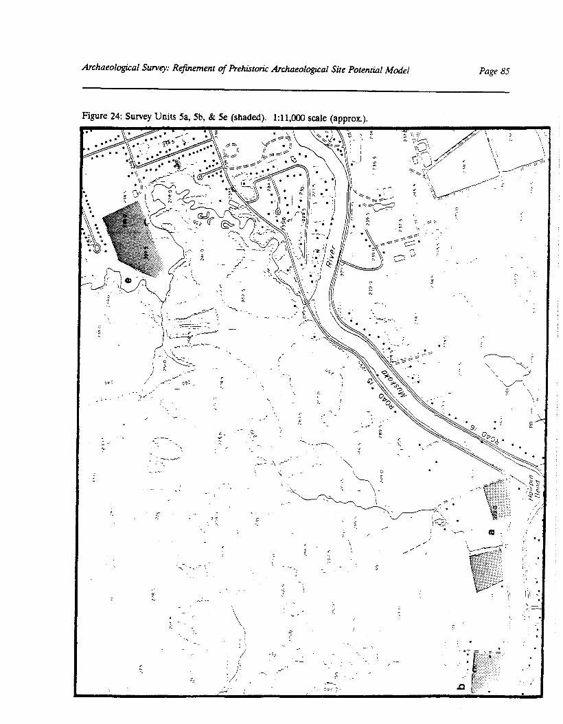
Archaeological Survey: Refinement of Prehistoric Archaeologil:al Site Potential Model Page 85
Figure 24: Survey Units Sa, 5b, & 5e (shaded). 1:11,000 scale (approx.).~~ '"
1(
j '"~
.,..;::r"---..,\~'- ~~~-,.- "-::::=:::":':"-"- ..
1;~ ....::...:4-'="'~...---,-:.~.-..-..""-"- T.:..
.:;~c>\j
c
"-
'"0f.
,//
c.
!I
/"/'
/'/'
\,\ Ii,
\l \- I. II'II

Page 86 Master Plan of Heritage Resources for theDistrict Mun~ipaliry of Muskoka and the Mohawks of Gibson
Figure 25: Survey Units 5c & 5d (dashed line). 1:50,000 scale.
rank,~land --
<
Stra: ~( :
Stra ~"iPo·,.
'.

Archaeological Survey: Refinement of PrehistorU: Archaeological Site Potential Model Page 87
Figure 26: Survey Unit Sf (shaded). 1:10,000 scale.
.' -:. ---~---HWY II
--.-
\IiI:III
i
t?

Page 88 Master Plan of Heritage Resources for theDistrict Munidpality of Muskoka and the Mohawks of Gibson
/'
Figure 27: Survey Units 5g & 5h (dashed lines and shaded), 1:50,000 scale,
..,~,
"
..... -- "-r--- "-\\\.,
\\
\,\\\\\,
\\\\I
"
:.\\ G\ \I'1\ __
/ _'1_~:;,- ./ ,I" ." \ 1'- .,-_I ~L "·j'(l('kQf,l'''.,:y~ -) \' '1.ok,
{\.
\:-'[.,it
-.
-- ..
t·1- ", \, \,.,'."
--'-'
\ -"" '"-,-= - """- I....."" -,~-=:~o:;~:,\--
_.",:-,:'; "". ~,
" .'.,
/
\c ~-\..~~...... '-'--\"\
.' ;.-'

ArchaeologiJ;al Survey: Refinement of Prehistoric Archaeological Sue PotenriAl Model Page 89
Figure 28: Survey Units 5i, 5j & 6a (dashed lines). 1:50,000 scale.
\'~J'
. .. -- .
r\ -
---o;:.:..?.:----_---- ..
---- :
,...- ..;;..... ,
One Tre-Islanc
\ .
\/,Centreview~Island
•-Snal(e
R.- lsia,.,j0::1(
ISla."l~
" .... '----

Page 90 Master Plan of Heritage Resources for theDistrict Municipality of Muskoka and the Mohawks of Gibson
Figure 29: Survey Unit 6b (dashed line). 1:50,000 scale.
/,- . - ---;-
.
.. / ... ~"c"A -,"(. ~ ~~ -_ .. ~/ -
.... : .;J,-~,y'.-e;..r- .,
.. ~\. -.:::i.
e::.-.
- F;;.f!ound,~O,,"r "

'.\~,
.. :....~~:.
',~;:,;..::~ . ..
]: 1.("11""",, ,..') .:t :.
.~.:~'~ .. ~,'- )~::-.. ~:t1'lIn·
... -'I)I. ill,·
'(".'II
r 1'llllH'I"4'
I.'~.'
1
1:,\t ' 'r~'
_i. /./ /"\
;"'; (\1.' c::-~ ,_ .•.. 'i ~ /'/\i
1,) (1---1:-<\\,>(\' \:i ;.::;(1- .. J (l ,"
) !1;:;'1'1'1 "~-.".',)I' -'
(
\
J
1:,"'1, ;.' /.,,-; /.
• i
.,',\\
....\ .'
.'
noc:klq!;mo
SnakeIsland
Anllm " •••• ";
.1<;I:\nd
"
,.-' \
,\
\" .. /
\'\\\
\I
)
/;
I
h..
I".", "
It,I', _
C\I
If
:!1 ~~ s-...no(b
~~~.(I)l:lc: .....j ~~c~e.~-
~ t0:~
S::TB. ...
~-~.~"-" ~Cj'- (Sv-~.0
§~
~ s-~ §.
~,
l:l.....tI)~.no
cl'...sg......
~~
,." : f 'f(('r
, IAJi:f'
,'J~rHri'~~l-I:i\\ I ~~'0_/./" , ,,' ....'-.
; ) : i ::

Page 92 Master Plan of Heritage Resources for theDist7U:t Municipality of Muskolw and the Mohawks of Gibson
Figure 31: Survey Units 7a & 7b (shaded).. 1:50,000 scale.
;1'
-' ,"
\;?' ..\\
'.'\I
/_.I
/
"'~.'
/\' --
~.;:~~~
.-....::- '-,

Archaeological Survey: Refinement of PrehistorU: Archaeological Sile Potential Model Page 93
Figure 32: Survey Unit Sa (shaded at arrow). 1:50,000 scale.
llhltehol' se
\'0:..")6 \Nro~~':~I '
\,\
-\\\\\~\\\
MIJllchampISland "
-:::-'ZephyrIslane
/'--'~'/,-
~"',I:
ChampIonIsland"
CastleISlandAquila
ISlandBa\
Fairview. --:::--
ISland, /' __ Fairview:.::::==~Island
.~-;~ ..
• -~_~.:: • ..!.. Joi POL1:
Par'lcaj(eIsland'
,-. Crown'~ Island /-
Roothog(- ,ISland L
S ...",---...-
• Price.=... Pc:- ..
':1":(,
:'. b
~ Hanes Island
-~:::~~>.... '/'~.~ --
: B:.trtlt lsicr;d
ScniJ/fl·,':......... Bc.:.:.L.a;' (' ~," ~ ;,'S-.~•":::.1JQ', ~' • ~'. """'3~:ic~~{!l!:-'~~ -"
/.-=-:',--' ,--- ."; ..-\ l,ll - r __
1 :'1< ..., F--=
~Ensko ISlan:::, ,, .::-:Burnl ISland
;."'-"""\;~
\,
E CliO
No:,\ ..a
Poe' '• .-J." .
~.\\\\
---\c-:-c\;- \
''"'\. __ , 1\
l.Clj'e
GO /" -------.
,~.-
Laic": ~•• __ ._. ..:, .
~..- ~ _.-1-
' .. \-c

Page 94 Master Plan of Heritage Resources for theDistmt Municipality of Muskoka and the Mohawks of Gibson
Figure 33: Survey Unit 8b (shaded). 1:10,000 scale. (\<11
!J
\
(
enommee Lake
\
\382 ~ ~o.,

Archaeological Sur;ey: Refinement of Prehistoric Archaeological Site Potential Model Page 95
Figure 34: Survey Unit Be (shaded). 1:10,000 scale.
32<.>0
3260
i")
"o
-----------
\\ ----

Page 96 Master Plan of Heritage Resources for theDistrict Municipality of MusJwka and the Mohawks of Gibson
Figure 35: Survey Unit 8d & Be (shaded). 1:10,000 scale.
Lckf
,
\
..,~\, -:\
", \. , \....... \,,\
",' \- .. '\. \, \ \-----1p~\,:
J/~\\f~;;":~
~ , \3~ -', (\
Y':..".'NEEDLER( POI~~;
,. .-- .~'
-'i /
/r(
,(
3E:
-- _ ... - ...
Of

3 SUMMARY AND CONCLUSIONSby R.L MacDonald
It is increasingly apparent that the District Municipality of Muskoka has supported humanoccupation since the retreat of the Wisconsin glacier some 11,000years ago. Although thereis as yet no concrete evidence of Paleo-Indian occupation, either during or immediately afterthe retreat of glacial Lake Algonquin, there is no reason to believe that such evidence willnot be forthcoming; indeed, Paleo-Indian sites are relatively rare throughout North America.There is, however, considerable evidence of aboriginal occupation from Archaic times up tothe present.
For the vast majority of this human prehistory, the population consisted of hunter-gathererbands which possessed an intimate knowledge of their band territory and the resources itoffered. To the casual modern observer, travelling through Muskoka on a four-lane highway,the region may appear to be a relatively homogeneous blend of mixed forest punctuated byrocky uplands and swamps. However, as the detailed regional studies undertaken by theHeritage Areas Program have demonstrated, Muskoka is an incredibly diverse landscapewith a definite texture and structure. The term "texture" is used here to refer to thefrequency with which environmental features change across the landscape, whereas"structure" refers to the overall pattern of environmental feature distribution. The intimacywith which the aboriginal hunter-gatherer understood this texture and structure, as well astheir implications for survival, cannot be achieved in studies such as this. Nevertheless, itis possible to begin to appreciate the fundamental structure of the landscape and how thisstructure may have constrained prehistoric land use. Understanding this relationship is thevery foundation of prehistoric archaeological site potential modelling.
Information concerning traditional patterns of land use can contribute a great deal towardsan understanding of landscape structure. While certain customs, such as gardening, mayhave been practiced for a relatively short time, many others are deeply rooted in prehistory.So, for example, an examination of activities such as hunting, fishing, bark collecting, berrycollecting, and travel, can serve as an important historic framework against which to evaluatehypotheses about the same activities in prehistory. In this study, many examples ofhistorically documented land use tended to follow patterns anticipated by the prehistoricarchaeological site potential model.
To a large extent the structure of the landscape and its effect on prehistoric land use canbe interpreted from maps, and this was done as a component of the Volume 1 research.In fact, the synoptic perspective afforded by relatively small mapping scales, such as 1:50,000,facilitates the identification of broad trends and patterns. Yet desktop modelling at such asmall scale does have significant limitations. While adoption of 1:50,000 as the analyticalscale was logistically necessary (see Volume 1, Section 1), the degree of generalization--orlack of resolution--at this scale proved to be enormous when viewed from the ground. Using
Archaeological Services Inc.

Page 98 Master Plan of Heritage Resources for theDistrict Municipality of Muskoka and the Wahta Mohawks
the draft 1:50,000 site potential maps in the field was impossible for all but the most generalorientation purposes; the difference in scale between the map and the real world wasequivalent to viewing an object with the naked eye and then under an electron microscope.Our only viable alternative was to use the 1:10,000 Ontario Base Maps in the field. Thisprovided a five times improvement in resolution, although there was still a ten thousandtimes difference between the map and the ground. These observations provided a practicalreminder of both the limitations inherent in the predictive model due to issues of scale andresolution (Volume 1, Section 1.3.2) as well as the attendant limitations with respect toapplication of the model on the ground (Volume 1, Section 1.8.4).
While the survey project was successful in documenting a number of previously unregisteredarchaeological sites, thereby fulfilling one of its primary objectives, these data alone mayactually contribute less to refinement of the predictive model than the knowledge of theregion that was a by-product of simply travelling to the various survey units, observing thelandscape, and talking with local residents. This amounted to a massive windshield surveyacross the entire District that turned the two-dimensional, mapped predictive model into athree-dimensional, high-resolution model--at least in the minds of the survey team. In turn,this greater familiarity with the District facilitated confirmation of many assumptions onwhich the desktop model was based as well as the identification of structural trends in thelandscape not apparent in the original exercise.
One assumption that was generally supported by the survey and Ithe traditional-useinformation was the degree to which water transportation determined prehistoric settlementin Muskoka. Indeed, the research into traditional use was able to confirm various canoeroutes predicted by the draft model. Since survival depended upon access to widely spreadresources, transportation would have been a major concern. What was not fully appreciated'prior to the fieldwork, however, was the extent to which settlement in Muskoka would havefocussed on a few major catchment areas: Georgian Bay, the Muskoka Lakes, Lake of Bays,and the Huntsville lake system. It is interesting to note how the fundamental structure ofthe landscape has influenced land use right up to the present, as evidenced by the currentorganization of townships.
Another consideration that arose repeatedly during the fieldwork was the effect of historicmodifications to the environment. It was a constant struggle to visualize the landscape asit would have appeared prior to historic logging. Aside from the current appearance of theforest, it is difficult to assess the impact of this activity in terms of erosion and modificationof regional hydrology. It was during this period of major logging activity that water levelsbegan to be artificially controlled in Muskoka, a practice that has been continued in largepart to accommodate the needs of hydro-electric generating stations. On all of the major
Archaeological Services Inc.

SUMMARY AND CONCLUSIONS Page 99
lakes, older residents recalled the days when, during summer low-water levels, it was possibleto drive a wagon team around the lakeshore. The general opinion was that current waterlevels were about four feet (1.3 m) above normal. While, as suggested in Volume 1 (Section1.7.1), this may fall within prehistoric seasonal and long-term extremes, there is a significantdifference between occasional or seasonal flooding and permanent inundation. Many of thesites documented during this survey had been affected by recent erosion, and it is expectedthat many more sites have been damaged or destroyed through inundation or erosion.
With respect to landscape texture, the severity of the topography surrounding many of thelakes became apparent during the survey. Many stretches of shoreline are simply too steepto permit settlement. As a result, suitable canoe-landing areas, such as sandy beaches,combined with flat, well-drained campsites, were identified as areas of high archaeologicalpotential. Unfortunately, beaches are generally not resolved on either 1:10,000 or 1:50,000maps. Points of land were considered to have particularly high potential, since they oftenpossessed a sheltered bay with a sandy beach as well as a good campsite with a wide vantageof the lake.
A total of twenty-five archaeological sites was registered as a result of this investigation(Table 3). At the same time, archaeologists from the Ministry of Transportation were in theprocess of registering four important new Woodland components (Baxter [BeGw-26],Bentley [BeGw-23], Bressette East [BeGw-25], and Bressette West [BeGw-24]) in the vicinityof Port Severn (Paul Lennox, personal communication, 1994). Although this virtuallydoubles the number of registered sites in Muskoka, it undoubtedly represents a smallfraction of the total number of extant sites, far too few to be able to construct a meaningfulculture history for the District. Nevertheless, the growing site database does provide a fewnotable insights.
The majority of sites consist of small assemblages of chert and quartz debitage, the by-product of chipped-stone tool manufacture. While some yield formal tools, such as hidescrapers, or expedient tools, such as utilized flakes, the discovery of temporally diagnosticprojectile points is relatively rare. In areas such as southern Ontario, where extensive surveywork has revealed recognizable trends in artifact loss and discard, it is not uncommon forhabitation sites to yield few complete projectile points, since these would have been curatedand re-used until lost or broken. As a result, projectile points are most frequently found asisolated findspots--presumably where they were lost--or as fragments discarded duringweapon refurbishment events. While site ages can be assessed through other methods, suchas radiocarbon dating of carbonized organic material, this process is costly and not usuallyundertaken in the course of archaeological survey. It is therefore impossible to assess theage of many sites except to conclude that, since chipped-stone tool manufacture disappeared
Archaeological Services Inc.

Page 100 Master Plan of Heritage Resources for theDistrU:tMunicipality of Muskolul and the Wahta Mohawks
quickly with the historic introduction of metal tools and weapons, they are likely prehistoric.
Of those sites that have yielded temporally diagnostic artifacts, many date to the Archaicperiod. This may be explained in part by the fact that the Archaic is by far the longest ofthe periods in the current paradigm of Ontario's prehistory. All things being equal, thereis therefOre a greater likelihood that a given site will derive from this time. Also, Archaicperiod projectile points and groundstone tools tend to be relatively large and more easilynoticed by the untrained eye. A similar fact may explain the frequency with which iron tradeaxes from the early historic period have been recovered.
It was quite gratifying to observe that all of the sites documented were situated in areaswhere the predictive model would expect them to be, and many were actually within specificzones of high to very high potential. While it might be argued that this reflects bias inherentin the survey strategy--that is, we only found sites where we looked for them--this is notreally true since in the majority of cases we merely documented sites previously found bylocal residents. Thus, the only inherent bias stems from the fact that modern settlement hastended to occur in the same locations as prehistoric settlement.
Often it is at least as important to understand why sites are not found in certain areas as itis to explain why they are where they are. However, given the scope and approach of thissurvey, there are few areas where this question can be considered. The most extensivesurvey work was undertaken in ploughed fields near Sparrow Lake and along the MuskokaRiver below Bracebridge. Only two sites were found as a result, and both were isolatedfindspots immediately adjacent to watercourses. While one might anticipate a significantdrop in site density as one moved away from the major lakes and rivers, such a conclusionwould be premature pending more detailed survey of these areas. In the case of rivers likethe Muskoka, site visibility may simply be masked by alluvial deposition on the floodplain.The only other obvious factor which is known to have affected site visibility and integritythroughout the District is water level. The effect of artificially high water levels was veryevident at the sites on Point Ideal, and the Severn Bridge site investigated by Ministry ofTransportation archaeologists provided good evidence of inundation during prehistoricfluctuations in the level of Lake Huron (Timmins 1993).
Aside from the scientific knowledge that was acquired in the course of this study, one of themost meaningful and rewarding insights gained was the profound sense of importance placedon archaeological heritage by the residents of Muskoka. Almost invariably, people wereastonished by the time depth of regional prehistory and were intrigued to know thatprehistoric archaeological sites were relatively common. At the same time, a remarkablenumber of residents were aware of artifact finds, yet had not given serious thought to their
Archaeological Services Inc.

SUMMARY AND CONCLUSIONS Page 101
age or significance. This tendency, for the general public to think of aboriginal culturehistory as being rather static and of short time depth, is common in Canadian society. Thefact that there is currently no institution in Muskoka interpreting First Nations' prehistoryto the public undoubtedly contributes to this perception. In discussing this problem withlocal museum curators, it was noted that--aside from the usual financial and logisticalconstraints--the proximity of Huronia, with its various institutions focussing on aboriginallifeways, has tended to create a vacuum in Muskoka. In fact, it could be argued that morearchaeological finds from Muskoka are displayed in institutions outside of the District thanwithin. One of the many ironies of this situation is that the differences in culture historybetween Muskoka District and Simcoe County are as radical as the ecological differencesbetween the two--indeed, the former arise from the latter. It is perhaps not surprising,therefore, that many Muskoka residents were of the opinion that a systematic treatment ofthe District's prehistoric past was long overdue. Moreover, many were clearly looking fora sustained programme of heritage conservation and public interpretation. Not only do theysee this as a very positive direction from the perspective of tourism and commerce, but asa crucial initiative in order to keep Muskoka in step with other provincial and nationaljurisdictions.
In conclusion, this second phase of the Muskoka archaeological resource master plan hasemployed oral history and documentary data concerning traditional aboriginal land use, aswell as information concerning archaeological sites and the landscape of the District, in orderto refine the prehistoric archaeological site potential model developed during phase one.As successful as this refinement has been, it is very much only the beginning of a process ofmodel improvement that will continue to develop as new sites are documented and a betterunderstanding of the prehistoric landscape is resolved. As a powerful planning tool, the sitepotential model provides an outline of prehistoric land use that is required in order to makeinformed heritage-resource management decisions. In no way is it considered to be acomprehensive or definitive work on the prehistory of the Muskoka District. Rather, it hasbeen designed as a framework to guide heritage planners and as a foundation on which tobuild a better understanding of the past. It is hoped that it will make a significantcontribution to a meaningful process whereby the District's archaeological heritage is:inventoried· through an on-going operation that facilitates heritage resource management;made accessible and interesting to the public through the display and interpretation ofimportant collections such as those held by the Muskoka Lakes Museum; and managedthrough progressive land-use and heritage resource planning.
Archaeological Services l1ic.

Master Plan of Heritage Resources for theDistlUt Munidpality of Muslwka and the Wahta Mohawks
Page 102
Table 3: Summary of Muskoka Survey Results--New Sites Registered
Borden Number Name Description Affiliation
BeGu-l Oark isolated Onondaga chert unidentified prehistoricflake
BeGu-2 Stan Clipsham isolated groundstone Archaicgouge
BeGu-3 Sara Clipsham Brewerton point, biface, stone tools - Middle2 grounds tone gouges, 3 Archaicgrounds tone celts, 3 iron iron axes - historicaxes
BeGu-4 Pope Petroglyph petroglyph site on unknown - probable lateSparrow Lake prehistoric or early
historic Native
BeGu-5 Kahshe Station isolated grounds tone celt unidentified prehistoric
BfGu-l Donnelly 1 stone tools recovered unidentified prehistoricfrom vegetable garden -large collectionphotographed by P.Carruthers of MCTR
BgGt-l High Falls 1 debitage in test pit on unidentified prehistoricportage
BgGt-2 High Falls 2 debitage in test pit on unidentified prehistoricportage
BgGt-3 High Falls 3 debitage and calcined unidentified prehistoricbone eroding fromriverbank on portage
BgGu-2 Bertha May 58 foot tug boat resting historic shipwreckin 10' of water offBarlochan
BgGv-4 Obogawanung island where Muskoka historic OjibwaLakes Museum nowstands was traditionalIndian village - site mayhave been capped by fillwhen locks were built
Archaeological Services Inc.

SUMMARY AND CONCLUSIONS Page 103
Table 3: Summary of Muskoka Survey Results--New Sites Registered
I Borden Number I Name I Description I Affiliation IBgGv-5 Jewitt isolated Brewerton Middle Archaic
comer-notched projectilepoint found on HurlingPoint, Muskoka River
BgGv-6 VVoodwinds~land projectile points found by unidentified prehistoricAlfred Smith on sandybeaches around island
BgGv-7 Knight artifacts in Muskoka Middle ArchaicLakes Museum recoveredfrom vicinity of creek onKnight property--ownerreportedly has largecollection
BgGv-8 Pamosagai probable historic Ojibwa . historic Ojibwavillage on Tobin ~land
BgGw-2 Tooke's ~land 2 comer-notched Middle or Late Archaicprojectile points, 1discoidal biface, and 1banded slate pendant inthe shape of a projectilepoint
BgGw-3 Renshaw iron trade axe, 4 flakes, early historicincluding a possiblespokeshave and ascraper/utilized flakefound at waterfrontacross from Tooke's~land--former portageroute with spring
BhGr-5 Turner's ~land Iroquoian pottery, 4 chert Middle Iroquoianscrapers, quartz bifaceand celt found by TedHungerford
Archaeological Services Inc.

Page 104 Master Plan of Heritage Resources for theDistrict Municipality of Muskoka and the Wahta Mohawks
Table 3: Summary of Muskoka Survey Results--New Sites Registered
I Borden Number I Name I Description I Affiliation IBhGr-6 Hungerford Brewenon side-notched Middle Archaic
point, banded slategouge, and banded slatecelt found by TedHungerford on beach
BhGr-7 Raynor Island iron trade axe found by early historicTed Hungerford (seventeenth century)
BhGs-5 Menominee Lake historic site, probable historiclogging camp, dating toturn of century
BhGs-6 Point Ideal 1 debitage in test pits on unidentified prehistoricsouth shore
BhGs-7 Point Ideal 2 debitage found in test unidentified prehistoricpits at various locationson south lawn of lodge--grounds tone celt andprojectile points found byRoss Boothby on beach
BhGs-8 Norway Point broadpoint and debitage Late Archaicrecovered by TedHungerford
Archaeological Services Inc.

REFERENCES CITED
Avery, Sidney G.1974 Reflections: Muskoka and Lake of Bays of Yesteryear. Bracebridge: Herald-
Gazette Press.
Bajc, A.F.1990 Quaternary Geology of the Huntsville-Bracebridge Area. Summary of Field
Work and OtherActivities, Ontario Geological Survey Miscellaneous Paper 151:152-156.
Coombe, G.1976 Muskoka Past and Present. Toronto: McGraw-Hill Ryerson.
Cumming, Ross (ed.)1972 Guide Book and Atlas of Muskoka and Parry Sound Districts. Toronto: H.R.
Page & Co. (Originally published 1879. Owen Sound: Richardson, Bond &Wright).
Dewdney, Selwyn and Kenneth E. Kidd1967 Indian Rock Paintings of the Great Lakes. Toronto: University of Toronto
Press.
Jenness, Diamond1935 The Ojibwa Indians of Parry Sound, Their Social and Religious Life. Canada
Department of Mines, National Museum of Canada, Bulletin No. 78,Anthropological Series 17, Ottawa.
Kenyon, Ian and Thomas Kenyon1987 The Iron Trade Axe in Ontario, ca. 1580-1650: Exploratory Data Analysis.
Kewa 87(7): 10-20.
Koennecke, Franz M.1984 Wasoksing, The History of Parry Island, An Anishnabwe Community in the
Georgian Bay. MA thesis, University of Waterloo.
Mason, D.H.C.1957 Muskoka: The First Islanders. Bracebridge: Herald-Gazette Press.
Archaeological Services Inc.

Page 106 Master Plan of Heritage Resources for theDistrict Municipality of Muskoka and the Wahta Mohawks
Murray, F.B.1963 Muskola1 and Haliburton, 1615-1875. Toronto: The Champlain Society.
Rogers, E.S.1973 The Quest for Food and Furs. National Museum of Canada, Publications in
Ethnology, No.5.
Ross, Brian D.1991 Historic Ojibway Cemeteries on Beausoleil Island, Georgian Bay Islands
National Park: Broadening Our Perspective. Unpublished report submittedto the Ontario Ministry of Culture, Tourism and Recreation.
Schell, Joyce I.1970 The Years Gone By. Bracebridge: Herald-Gazette Press.
Scovell, Beatrice1983 The Muskola1 Story. Privately printed.
Storck, Peter L.1982 Palaeo-Indian Settlement Patterns Associated with the Strandline of Glacial
Lake Algonquin in Southern Ontario. Canadian Journal of Archaeology 6: 1-31.
Timmins, Peter A.1993 The Severn Bridge Site (BeGw-21): A Multi-Component Camp at the Mouth
of the Severn River. Unpublished report. Ontario Ministry ofTransportation, Environmental Unit, Southwest Region.
Vastokas, Joan M. and Romas K. Vastokas1973 Sacred Art of the Algonkians: A Study of the Peterborough Petroglyphs.
Peterborough: Mansard Press.
York North Archaeological Services (Y.N.A.S.)1991 An Archaeological Survey of Bigwin Island, Lake of Bays. Unpublished
report submitted to the Bigwin Resort and Development Corporation.
Archaeological Services Inc.

Appendix 1 . Artifact Catalogue
Archaeological Services Inc.

Page No.02/15/94
Master Plan of Archaeological ResourcesDistrict Municipality of Muskoka
Clark Site (BeGu-1)Surface Survey--June 1993
CatNo Artifact F req COlIIIlent
1 UTILIZED FLAKE.- Total ***

Pege No.02/15/94
CetNo Artifect
Mester Plen of Archeeological ResourcesDistrict Municipality of Muskoke
Sten Clipsham Site (BeGu·2)Photogreph Only of Privete Collection
Freq Comnent
1 GClJGE_. Totel _.
privete collection

Page No.02115/94
CatNo Artifact
Master Plan of Archaeological ResourcesDistrict Municipality of Muskoka
Sara Clipsham Site (BeGu-3)Photographs of Private Collection
F req COllIIlent
1 PROJECTILE POINT2 BIFACE3 GOOGE4 GOOGE5 CELT6 CELT7 CELT8 AXE9 AXE
10 AXE*** Total ***
1 private collection111111
111
10

Page No.02115/94
CatNo Artifact
Master Plan of Archaeological ResourcesDistrict Municipality of Muskoka
Kahshe Station Site (BeGu·5)Surface Collection
Freq Conment
1 CELT... Total -* June 1993

Palle No.02/15/94
CatNo Artifact
Master Plan of Archaeological ResourcesDistrict Municipality of Muskoke
Donnelly Site (BfGu-1)Private Collection
Freq Carment
1 MISC CHIPPED LITHICS + private collection
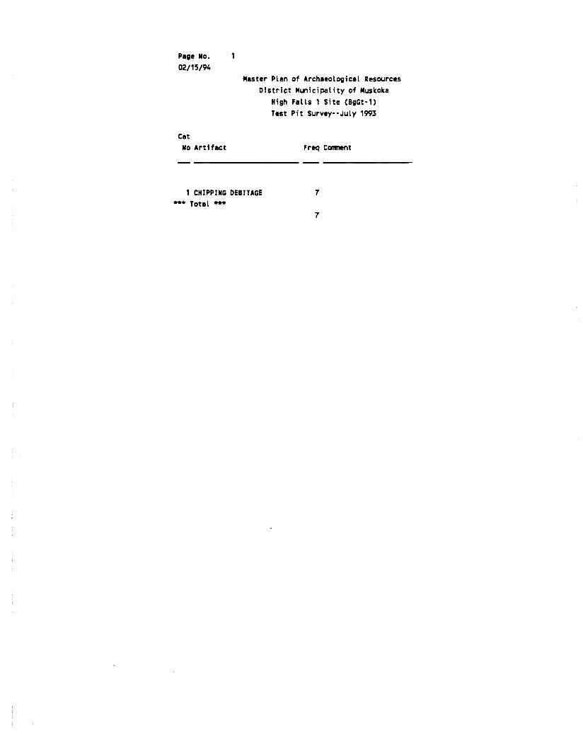
Page No.02/15/94
Master Plan of Archaeological ResourcesDistrict Municipality of Muskoka
High Falls 1 Site (BgGt·1)Test Pit Survey··July 1993
CatNo Artifact Freq Conment
1 CHIPPING DEBITAGE*** Total ***
7
7


![ERASMUS+:ERASMUS MUNDUS Master in ARCHaeological … · ERASMUS+:ERASMUS MUNDUS Master in ARCHaeological MATerials Science Student Agreement [20...- 20.. Edition] The Universidade](https://static.fdocuments.in/doc/165x107/5f62f1b80ac39211a331afb3/erasmuserasmus-mundus-master-in-archaeological-erasmuserasmus-mundus-master.jpg)