
Report of Thailand - United Nationsunstats.un.org/unsd/geoinfo/RCC/docs/rccap20/CRP1... · ECONOMIC...
11
UNITED NATIONS E/CONF.104/CRP.1 ECONOMIC AND SOCIAL COUNCIL Twentieth United Nations Regional Cartographic Conference for Asia and the Pacific Jeju, 6 - 9 October 2015 Item 7 a) of the provisional agenda Country reports Report of Thailand * _________ *Submitted by Royal Thai Survey Department (RTSD)
Transcript of Report of Thailand - United Nationsunstats.un.org/unsd/geoinfo/RCC/docs/rccap20/CRP1... · ECONOMIC...

UNITED NATIONS E/CONF.104/CRP.1 ECONOMIC AND SOCIAL COUNCIL Twentieth United Nations Regional Cartographic Conference for Asia and the Pacific Jeju, 6 - 9 October 2015 Item 7 a) of the provisional agenda Country reports
Report of Thailand * _________ *Submitted by Royal Thai Survey Department (RTSD)

- 1 -
Report of Thailand
Relating to Geodesy, Geophysics and Geographical Information System Activities
during the period of 2013-2015
The Country report of Thailand described the activities and works relating to geodesy,
geophysics and geographical information system during the period of 2013-2015 was prepared by
four agencies namely Royal Thai Survey Department, Chiang Mai University, Department of
Mineral Resources, and Department of Disaster Prevention and Mitigation. 1. The Royal Thai Survey Department The Royal Thai Survey Department (RTSD) is the national mapping agency under the Royal Thai Armed Forces Headquarters who is responsible for surveying and producing maps of Thailand for the purposes of national security and development. The activities that RTSD has carried during the period under review are two main tasks:
1.1 Geodetic tasks
The Royal Thai Survey Department
(RTSD) is responsible for the establishment of
Geodetic Network in Thailand. The horizontal
networks have been performed by using the Global
Positioning System (GPS). For past three years
during 2013 - 2015, RTSD has regularly conducted
survey on geodesy and monitored the incidences on
the earth which has changed over time. Especially,
the disaster of the earthquake and the movement of
tectonic plates, these directly affect to the stations
of national geodetic network.
Therefore, RTSD still had continuously
implemented GPS observation for inspecting,
developing and improving the accuracy and up-to-date
coordinates of horizontal control network in
accordance with the international standards and
Federal Geodetic Control Committee (FGCC) of
the United States including 8 stations of Reference
Network, 19 stations of Primary Network, 94
stations of Secondary Network and 381 stations of
Auxiliary Network. All these stations are
on International Terrestrial Reference Frame (ITRF) 2008 datum (epoch 2013.10) and available
for supporting further to government and civilian
agencies who use our survey results for mapping
and others.
Figure 1: The Movement of Plate Tectonic in Thailand
(W.J.F. Simons, 2010)

- 2 -
Control
Center
Civilian and
Official Users
(Observing Data)
INTERNET
GNSS Base Station
For the development in the future, RTSD will focus on the geodynamics, and the unity of
the coordinate systems (horizontal and vertical) used in both local and international levels.
Especially, the establishment of base stations of automated GNSS satellite observation and the
development of high precision geoid model of Thailand, these are expected that the success of both
tasks will result in a change of surveying for national infrastructure and it can also be used to prepare
to cope with natural disasters that may happen to Thailand in the future.
Figure 2: Reference, Primary, Secondary and Auxiliary Networks
Figure 3: The Establishment of Base Stations of Automated GNSS Satellite Observation
- 3 -
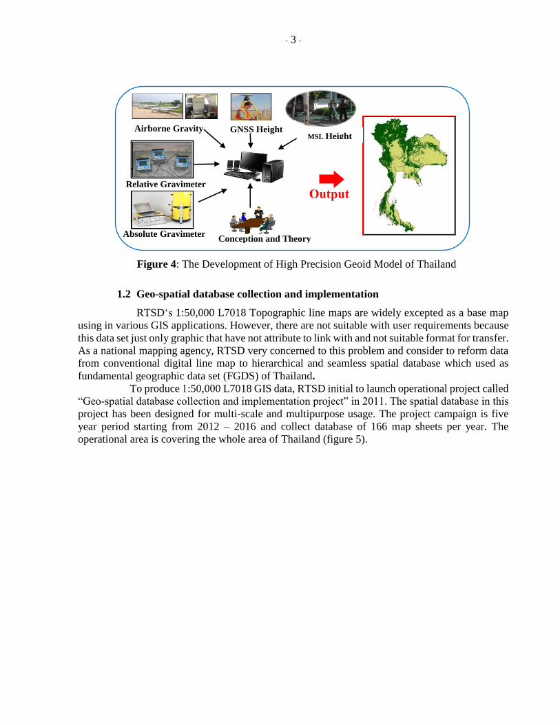
1.2 Geo-spatial database collection and implementation
RTSD‘s 1:50,000 L7018 Topographic line maps are widely excepted as a base map
using in various GIS applications. However, there are not suitable with user requirements because
this data set just only graphic that have not attribute to link with and not suitable format for transfer.
As a national mapping agency, RTSD very concerned to this problem and consider to reform data
from conventional digital line map to hierarchical and seamless spatial database which used as
fundamental geographic data set (FGDS) of Thailand.
To produce 1:50,000 L7018 GIS data, RTSD initial to launch operational project called
“Geo-spatial database collection and implementation project” in 2011. The spatial database in this
project has been designed for multi-scale and multipurpose usage. The project campaign is five
year period starting from 2012 – 2016 and collect database of 166 map sheets per year. The
operational area is covering the whole area of Thailand (figure 5).
Figure 4: The Development of High Precision Geoid Model of Thailand
ORelative Gravimeter
Output
Absolute Gravimeter Conception and Theory
Airborne Gravity GNSS Height MSL Height

- 4 -
Figure 5: Operational area and production plan
RTSD adopted US. Geo-spatial Intelligence Agency (NGA) spatial database structure
to implement this GIS database and used Feature Attribute Coding Catalog (FACC+), Digital
Geographic Information Exchange Standard (DIGEST) developed by the Digital Geographic
Information Working Group (DGIWG), to coding the geographic feature.
During 2012 – 2015 fiscal year, 478 map sheets or about 58% of operational area was
surveyed by Geography Division of RTSD. Many attributes of digital line map are classified by
field survey using mobile technologies and geo-tagging photo are used to validate the completeness
and accuracy (figure 6).Seamless storage of vector and imagery data is final output of this project
that ready to using in various GIS application and cartography. RTSD believe that this L7018
digital line map development to geo-spatial database will be support GIS applications and enhance
Thai spatial data infrastructure (SDI) development in the future.

- 5 -
a) Project progression b) RTSD‘s GIS data sample
Figure 6: Project progression and GIS data sample
2. Chiang Mai University
Chiang Mai University was founded in January 1964, under a Royal Charter granted by His
Majesty King Bhumibol Adulyadej. And CMU was the first institution of higher education in the
north, and the first provincial university in Thailand.
We have four campuses together, Suan Sak (garden of teak), Suan Dok (garden of flowers),
Mae Hea, and Sri Bua Baan campus. These campuses are sited of the Faculties of Agriculture,
Architecture, Business Administration, Science, Engineering, Humanities, Social Sciences,
Education, Fine Arts, Economics, Law, Mass Communication, Political Science and Public
Administration, the College of Arts Media and Technology, the Graduate School, Medicine,
Associated Medical Sciences, Nursing, Dentistry, Pharmacy, the Maharaj Nakorn Chiang Mai
Hospital, Veterinary Medicine, and Agro-Industry
The activities on Cartography, Geographic Information System (GIS), and Geo-informatics
(GI) of the involved departments of Chiang Mai University are research projects and publications
in several aspects as followings.
Completed In progress

- 6 -
2.1 Spatial Clustering of Burned Areas for Open Field Burning Surveillance and Prevention:
Case Studies of Chiang Mai, Lamphun and Mae Hong Son Provinces, 2014. Dr.Suttinee
Dontree, Dr.Aphiradi Soravisutr, and Dr.Photchana Phichitputja
This research has four objectives and its results are firstly, created database of the open field
burning of study area for physical condition study and statistical analysis. Secondly, in the study
area had burning occurrences differently depending on location, topography, climate conditions,
land use, and people’s socio-economic conditions. Thirdly, relevant stakeholders had different
opinions towards fire usage and wild fires, Fires had more advantages for farmers for crop residual
elimination and accelerating food and income from non-timber forest products. And finally, there
were many solutions of fire and smoke problems. Villagers used some methods appropriates to
their livelihood while government departments used law enforcement and top-down commands.
2.2 Investigation internal parameter of neural network model for flood forecasting at Upper
River Ping, Thailand KSCE Journal of Civil Engineering (in press). Dr. Tawee
Chaipimonplin
Due to the incomplete of necessary data within catchment area of Upper Ping River, the study
of Neural Network modelling with the algorithm of Bayesian Regularization (BR) and Levenberg-
Marquardt algorithm for flood forecasting are founded that the Levenberg-Marquardt algorithm
had been presented the better predicted result.
2.3 Development of Neural Network model for water level forecasting for flood warning in
Nam Mun Catchment, 2013. Dr. Tawee Chaipimonplin
This research has been investigated in input determination techniques and several of
parameters, which are changing the numbers of hidden node and comparing learning algorithm
types; LM and BR, may increase the ANN model’s performance for water level forecasting, the
peak of water level forecasting and flood warning in the study area. And found that artificial neural
network are many potentials in water level forecasting and peak events.
2.4 The used of radar imagery and hydrology information with artificial neural network model
for flood forecasting in Upper Ping Catchment, Journal of Science and Technology, 2013.
Dr. Tawee Chaipimonplin
This research investigates several parameters, i.e. water level, outflow discharge rate from a
dam and radar images. These might increase the model’s performance for water level forecasting
at the P.67 station within Chiang Mai city area. The result exhibit that adjusting the water level at
P.75 (upper river station) with various input of outflow discharge rates with radar images improve
the model’s performance. The model can predict water level at the P.67 at 18 hour in advances.
Moreover, integration between the models with the current flood warning system might be a new
method of increasing flood warning time at the P.1 station.
2.5 Changes in Temperature and Precipitation Extremes in Northern Thailand, 2014. Dr.
Chakrit Chotamonsak
This study was analyzed changes in temperature and precipitation extremes in northern
Thailand for the period 1981-2011.The study includes an analysis of the average and trends of
changes in temperature and precipitation using 22 climate indices, related to the intensity,
frequency and duration of extreme climate events. The results showed that the averaged trend of
maximum, minimum and mean temperature is likely to increase over the study area in rate of 0.5,
0.9 and 0.7 °C in last 30 years.

- 7 -
2.6 The development techniques in geoinformatics to support the supply chains management
and the logistics of economic crop, case study para-rubber in the Upper North of Thailand,
2013. The Upper North Regional Center of Geo-Informatics and Space Technology
From the considerate five factors of locations, basic structures, economic structures, local
logistics activities, and government policies, the study found that the policies from government
sector is the most important and follow respectively in location, basic structures, economic
structure and local logistics activities. That reflect to the development pattern that still depend on
the government planning and policies. It might be obstruct the development efficiently because of
sometimes policies are not issue from the proper consideration.
2.7 Land use Database Development From the Object-oriented Multispectral Imagery
Classification in The Area of Eight Northern Provinces, 2013. The Upper North Regional
Center of Geo-Informatics and Space Technology
This study aims to study and develop the techniques of the multispectral satellite image
classification. And to develop the land use database in the area of eight Northern provinces. The
result from the object-oriented classification produced the 15 types of land cover compose of cloud,
shadow, forest, field crop, grove wood, city area, water area, bare soil, mixed forest, orchard, teak,
plant forest, Eucalyptus field, and Para rubber field. Within the eight northern provinces of Chiang
Mai, Chiang Rai, Lamphun, Lampang, Phrae, Nan, Phayao, and Mae Hong Son.
2.8 The development potential assessment of the catchment area by geoinformatics techniques:
case study in the Upper North Ping River basin, 2014. The Upper North Regional Center
of Geo-Informatics and Space Technology
This study aim to define the factors that involve with the runoff volume by using the artificial
neural network (ANN). The analysis factors can be divided into three groups of climate, hydrology,
and land surface factors. The climate factors are the daily rainfall, daily maximum and minimum
temperature, and relative humidity. The hydrology factors are daily runoff, and sediment. And the
land surface factors are the areas of forest, farming, city, and open water area.
2.9 Feasibility and Environmental Impact Study of Tonpao Bypass Construction Project
Around Intersection of Roadways 121 and 1014, San Kamphaeng, Chiang Mai, 2014.
Associate Professor Dr. Aphichat Sopadang
In order to solve the traffic congestion problem, the Office of the National Economics and
Social Development Board and Bureau of the Budget in Thailand consider the construction of
Tonpao bypass project which is around the intersection between roadways of 121 and 1014, San
Kamphaeng, Chiang Mai. The Department of Rural Roads was assigned to take a responsibility for
the project feasibility study and the Initial Environmental Examination (IEE) study report. The
proposed project was expected to reduce travel time and cost, save some energy, and improve
roadways connectivity. The objectives of this project are (1) to identify the proper construction site
and to provide the conceptual design of roadways project and its extensions to the connecting
Roadways of 3029 and 4039, (2) to study the engineering, economic, social, and environment
evaluation, and (3) to evaluate the Initial Environmental Examination (IEE).
2.10 Lampang Provincial System management for Logistics Hub Development, 2015.
Associate Professor Dr. Aphichat Sopadang
This study aim to utilize the information various aspects from the local and non-local
stakeholders to the products and on land services linkage center of Lampang province to

- 8 -
positioning the functional organizations and spatial management with in the area of Lampang
province. This study utilize the GIS for spatial potential analysis to select the area of logistics hub.
3. Department of Mineral Resources
3.1 Geological Map Status of Thailand
The Mineral Resources Information Center (MRIC) of the Department of Mineral
Resources (DMR) has been set up by the minister of the Ministry of Natural Resources and
Environment since 19 January 2012 ; the MRIC is the geological and mineral resources information
center applying suitable information technology as a tool to increase efficiency of geological and
mineral resources management in Thailand (i.e., data acquisition, storage, processing and
dissemination), and the MRIC manages the computer system, geological data network of DMR,
and also produces geological and mineral resources maps of Thailand. These maps are produced
and printed out by the Cartography Section of MRIC. Moreover, the Cartography Section of MRIC
is the official source for distributing geological and mineral resources map of Thailand within DMR
and outside. The geological map status can be concluded below.
3.1.1 Geological map at the scale 1:2,500,000 was produced in 2003.
Unfortunately, this geological map is not available for commercial service, however, this
geological map can be observed in the Geological Resources Atlas of Thailand, and this atlas is
available for commercial service.
3.1.2 Geological map at the scale 1:1,000,000 The recently version of geological
map at the scale 1:1,000,000 was in 1999.
3.1.3 Geological map at the scale 1:500,000 has been produced since 1983 divided
into five parts covering the whole country including northern, northeastern, central and eastern,
western and southern parts of Thailand; Geological maps at the scale 1:500,000 of five parts of
Thailand can be divided into nine quadrangles as follows two quadrangles in northern part, two
quadrangles in northeastern part, two quadrangles in central and eastern part, one quadrangle in
western part, and two quadrangles in southern part.
3.1.4 Geological map at the scale 1:250,000 was produced by Thai geologist
during 1970 to 1980 was published 40 quadrangles and under the Thai-German Cooperation
mapping Project during 1975 to 1982, total seven quadrangles including Nan, Chiang Rai, Phayao,
Chiangdao, Chiang Mai, Li and Thong PhaPhum, therefore the total published maps are 47
quadrangles.
Moreover, provincial geological map of 66 provinces at the scale 1:250,000 was produced
under the project the mineral zoning and geological resources management during 2006 to 2014 of
66 provinces
3.1.5 Geological map at the scale 1:50,000 is the most important mission of DMR,
moreover, DMR’s geological maps are accepted by other geologists in the country and abroad.
Thailand during 1984 – 2015, 653 of 830 quadrangles were carried out.
3.2 Application of Geological Map to Geo-Hazard Maps for mitigation and
preparedness of Geohazards
3.2.1 The landslide Risk Map in Community level; Since 2003, DMR has
established landslide project, one objective is to map the landslide prone area at community level
at a scale 1: 10,000. The map shows the areas where prone to affect landslide and flash flood.
Moreover it shows the location of landslide watch network houses, safety places and rain gauges.
Since 2013 DMR has provided the map in 370 sub-districts in northern, southern part of Thailand.
3.2.2 Active fault map of Thailand; The previous version of active fault map of Thailand
was published in 2006. The recent version of active fault map of Thailand has been published since

- 9 -
2012. The new active fault map of Thailand consists of 14 active fault zones as follows; from north
to south, these active fault zones include the Mae Chan, Mae Ing, Mae Hong Son, Mae Tha, Phayao,
Pua, Thoen, Moei (or Mae Ping), Uttaradit, Petchabun, Sri Sawat, Three Pagoda, Ranong, and
Klong Marui Faults.
3.2.3 Seismic hazard map; The seismic hazard assessment was carried out in the Chiang
Rai, Chiang Mai, and Lampun provinces, northern Thailand. Regarding, a large earthquake of
Richter magnitude 6.3 occurred on the northeastern part of the Mae Lao segment of the Phayao
Fault on 5 May 2014. The epicenter was located in the Mae Lao district, Chiang Rai province,
northern Thailand; this event caused major damages in the Ching Rai province. Moreover, one
person died during the earthquake. In order to have the seismic hazard zones of northern Thailand,
The main objective of this project is to produce the probabilistic seismic hazard map of the Chiang
Rai, Chiang Mai, and Lampun provinces, northern Thailand (scale 1:50,000). This probabilistic
seismic hazard map shows the peak ground acceleration (PGA) values that a site can expect during
the next 50 years with 10 percent probability. The PGA values of this probabilistic seismic hazard
map will be converted to the Modified Mercalli intensity (MMI) scale. Therefore, both the PGA
values and MMI scale of probabilistic seismic hazard maps of the Chiang Rai, Chiang Mai, and
Lumpun provinces will be published.
3.3 Web services This project has internally launched in 2013. The outstanding movement after DMR had
participated in training and workshop concerning with an establishment of “WebGIS” portal and
creation of WMS is an implementation and development of new web services portal. The training
and workshop were conducted by GSJ/AIST. Either WebGIS portal or web services are based on
OGC standard. This means that DMR prefers to implement FOSS for future development. The
movement believes to lead sustainable contribution of facts and dissemination of knowledge and
activity to the public. Therefore, DMR does not hesitate to continue study and research on web
services in order to improve the web features to meet the more public satisfaction. Currently, the
services support 3 means of accessibility that are website, smart devices and GIS software. It is
believed that public can approach to the contribution and dissemination more easily and
convenient.
Direct access to the disseminated WMS is http://wms2.dmr.go.th/gisdmr_kml _EN.html
consequently. This can also be easily accessed by all smart devices.
Actually DMR has outsourced to establish web services since 2004, these services were
developed and created base on a well-known commercial software. There are source disadvantages
of the previous web services. The most significant disadvantage is a lack of capacity building either
knowledge or skill to keep self-confidence. Besides, complex services also retrograded public
satisfaction and failure on matters of dissemination.
4. Department of Disaster Prevention and Mitigation
Department of Disaster Prevention and Mitigation (DDPM), Ministry of Interior is the
focal government agency in charge of disaster management in Thailand. In order to better manage
disaster risks, DDPM has developed the “Disaster Information Portal (DIP)” to link and incorporate
all relevant information on disaster risks from all agencies concerned. This DIP has served as the
platform for data and information sharing as well as provision of disaster risk forecast and data
bank. DIP comprised three main components: (i) development and update of the disaster data bank,
(ii) conduct information technology need assessment of relevant agencies, and (iii) development
of methods for information linkage and sharing between DDPM and concerned agencies.

- 10 -
4.1 ITC application in disaster management
Information technology and communication system can be applied in all phases of disaster
management. It is very much depends upon the context and needs of the users. In Thailand ITC is
used in each phase as the following:
1) Prevention phase
- Do surveys and stocking of geographical information and disaster repetition in the archive
of the database;
- Update the attributes and information of the risk areas for a more accurate simulated
disaster models; and
- Get feedback to the database and adjust the emergency operation plan as appropriate.
2) Preparation phase
- Use geographical information system (GIS) and remote sensing to run the data scenario
based on updated spatial model together with meteorological model and hydrological and
hydraulic models;
- Convert to hazard maps and risk maps with models to communicate with models to
communicate with the public and concerned authorities in disaster monitoring and warning;
- Collect more information at field to reassure the accuracy of the simulated disaster
scenarios;
- Prepare for evacuation of people, live-stock and properties, if necessary; and
3) Post crisis assessment phase
- Develop damage summary report for further plan and relief funding;
- Utilize ITC and disaster database for proper management of disaster equipment and tools;
and
- Develop post-disaster assessment report for long-term planning of disaster risk prevention
and mitigation.
4.2 National Disaster Data Bank
According to Disaster Prevention and Mitigation Act 2007, the Department is mandated to
act as the principal agency to develop a common platform for disaster information sharing and
communication among concerned authorities and to synergize that information for integrated
disaster management, DDPM, therefore, improves its database and the national data bank to include
the following information;
4.3 Disaster database of DDPM
1) Current database
- Disaster Management Information System/Geo-Informatics System (MIS/GIS)
- Civil Defence Volunteers, Mr.Warning, Community Based Disaster Risk
Management (CBDRM)
- Disaster Risk Prone Area Mapping such as landslide, drought, repetitive flood
prone areas within 7 years, tsunami
- GIS Base map
2) Additional Database
- GIS Heavy machines and tools and equipment
- GIS monthly road accident statistics
- GIS safe zones and temporary shelters
*********************************