Report of Geotechnical Exploration For Geotech Report.pdf · Report of Geotechnical Exploration For...
64
Report of Geotechnical Exploration For University of North Florida Parking Lot 11 Jacksonville, Florida MAE Project No. 0019-0008 January 13, 2017 Prepared for: GAI Consultants 1301 Riverplace Boulevard, Suite 900 Jacksonville, Florida 32207 Prepared by: 8936 Western Way, Suite 12 Jacksonville, Florida 32256 Phone (904) 519-6990 Fax (904) 519-6992
Transcript of Report of Geotechnical Exploration For Geotech Report.pdf · Report of Geotechnical Exploration For...

Report of Geotechnical Exploration For
University of North Florida
Parking Lot 11 Jacksonville, Florida
MAE Project No. 0019-0008 January 13, 2017
Prepared for:
GAI Consultants
1301 Riverplace Boulevard, Suite 900 Jacksonville, Florida 32207
Prepared by:
8936 Western Way, Suite 12 Jacksonville, Florida 32256
Phone (904) 519-6990 Fax (904) 519-6992

8936 Western Way, Suite 12 Jacksonville, Florida 32256 Phone: (904)519-6990 Fax: (904)519-6992
January 13, 2017 GAI Consultants, Inc. 1301 Riverplace Boulevard, Suite 950 Jacksonville, Florida 32207
Attention: Mr. Timothy Focht, P.E.
Reference: Report of Geotechnical Exploration UNF Parking Lot 11 Jacksonville, Florida MAE Project No. 0019-0008
Dear Mr. Focht:
Meskel & Associates Engineering, PLLC (MAE) has completed a geotechnical exploration for the subject project. Our work was performed in general accordance with our proposal dated October 18, 2016. The purposes of this geotechnical exploration were to explore the existing pavement section and underlying subgrade conditions within the existing parking area, explore the shallow subsurface conditions at the two proposed dumpster pad locations, measure the depth to the encountered groundwater level and provide an estimate of the seasonal high groundwater level, and provide recommendations for design and construction of the proposed dumpster pads and construction recommendations for the parking area.
In summary, our field exploration within the existing parking lot encountered a pavement section consisting of a surficial asphalt course, ranging from 1-1/4 to 2 inches in thickness, underlain by a limerock base course ranging from 5 to 7-1/2 inches in thickness. The exception was at core location C-14, where the pavement core encountered approximately 7 inches of concrete. No apparent base material was encountered below the concrete layer. The soil borings advanced beneath the pavement surface at each core location generally encountered fine sands (SP) and fine sands with silt (SP-SM) to the boring termination depths of 6 feet below existing grade. The soil borings for the proposed dumpster pads encountered the surficial pavement section underlain by medium dense to loose fine sands (SP) and fine sands with silt (SP-SM) to the boring termination depth of 10 feet below grade. Groundwater, where encountered, was measured at depths ranging from 3 feet 5 inches to 5 feet 10 inches below existing grade. Based on our field exploration, there appear to be no adverse subsurface conditions below the existing pavement. The subsurface conditions within the 2 dumpster pad areas appear to be suitable for the planned construction, assuming the site preparation recommendations provided in this report are followed.
We appreciate this opportunity to be of service as your geotechnical consultant on this phase of the project. If you have any questions, or if we may be of any further service, please contact us.
_______________________________________ _______________________________________ W. Josh Mele, E.I. P. Rodney Mank, P.E. Staff Engineer Principal Engineer Licensed, Florida No. 41986 Distribution: Mr. Timothy Focht, P.E. - GAI Consultants, Inc. 2 copies; 1 pdf
rodney
Text Box
P. Rodney Mank, State of Florida, Professional Engineer, License No. 41986. This item has been electronically signed and sealed by P. Rodney Mank, P.E. on 01/13/2017 using a Digital Signature. Printed copies of this document are not considered signed and sealed and the signature must be verified on any electronic copies.

University of North Florida (UNF) Lot 11 MAE Report No. 0019-0008
8936 Western Way, Suite 12 Jacksonville, Florida 32256
Phone: (904)519-6990 Fax: (904)519-6992
Page | i
TABLE OF CONTENTS
Subject Page No. 1.0 PROJECT INFORMATION ................................................................................................................ 1
1.1 General ............................................................................................................................................................. 1 1.2 Project Description ..................................................................................................................................... 1
2.0 FIELD EXPLORATION ...................................................................................................................... 1 2.1 Pavement Cores ............................................................................................................................................ 1 2.2 Auger Borings ............................................................................................................................................... 1 2.3 SPT Borings .................................................................................................................................................... 2
3.0 LABORATORY TESTING .................................................................................................................. 2 3.1 Soil Index Tests............................................................................................................................................. 2
4.0 GENERAL PAVEMENT & SUBSURFACE CONDITIONS ............................................................ 2 4.1 Pavement Core Samples ........................................................................................................................... 2 4.2 General Soil Profile ..................................................................................................................................... 3 4.3 Groundwater Level ..................................................................................................................................... 3 4.4 USDA Web Soil Survey Data .................................................................................................................... 3 4.5 Seasonal High Groundwater Level ...................................................................................................... 4
5.0 DESIGN RECOMENDATIONS .......................................................................................................... 4 5.1 General ............................................................................................................................................................. 4 5.2 Pavement Considerations ........................................................................................................................ 4 5.3 Dumpster Pad Foundation Considerations ...................................................................................... 5
6.0 SITE PREPARATION AND EARTHWORK RECOMMENDATIONS ........................................ 6 6.1 Clearing and Stripping ............................................................................................................................... 6 6.2 Temporary Groundwater Control ........................................................................................................ 6 6.3 Compaction .................................................................................................................................................... 7 6.4 Structural Backfill and Fill Soils............................................................................................................. 7 6.5 Foundation Areas ........................................................................................................................................ 7
7.0 QUALITY CONTROL TESTING ....................................................................................................... 8 8.0 REPORT LIMITATIONS .................................................................................................................... 8

University of North Florida (UNF) Lot 11 MAE Report No. 0019-0008
8936 Western Way, Suite 12 Jacksonville, Florida 32256
Phone: (904)519-6990 Fax: (904)519-6992
Page | ii
TABLES Table 1 – Pavement Core and Base Conditions FIGURES
Figure 1. Site Location Map Figures 2, 2A. Boring and Core Location Plan Figures 3-9. Generalized Soil Profiles
APPENDICES Appendix A. Soil Boring Logs Field Exploration Procedures Key to Boring Logs Key to Unified Soil Classification System Appendix B Summary of Laboratory Test Results Laboratory Test Procedures Appendix C. Pavement Core Photographs

University of North Florida (UNF) Lot 11 MAE Report No. 0019-0008
8936 Western Way, Suite 12 Jacksonville, Florida 32256
Phone: (904)519-6990 Fax: (904)519-6992
Page | 1
1.0 PROJECT INFORMATION 1.1 General Project information was provided to us by you and Mr. Nick Mousa, AICP with GAI Consultants, Inc., and Mr. Jeff Auld, P.E. with McVeigh & Mangum Engineering, Inc. We were provided with the following documents for our review and reference:
• Preliminary Site Plan prepared by GAI Consultants, last dated August 12, 2016.
• Dumpster Enclosure Plan and Details (Sheet A-1) for the proposed dumpster pads, prepared by Baker Barrios, project architect, and dated January 11, 2017.
1.2 Project Description The general project location is on the University of North Florida (UNF) campus, which is generally north of JTB Boulevard and east of I-295 in Jacksonville, Duval County, Florida. The general site location is shown on Figure 1.
Based on the information provided to us, we understand that the existing asphalt wearing course within Parking Lot 11 on the UNF Campus will be milled and resurfaced. We also understand that two dumpster pads are planned, with each to be constructed as a slab-on-grade structure utilizing shallow foundations to support columns for the enclosure.
If actual project information varies from these conditions, then the recommendations in this report may need to be re-evaluated. Any changes in these conditions should be provided so the need for re-evaluation of our recommendations can be assessed prior to final design.
2.0 FIELD EXPLORATION A field exploration was performed on December 14 and 15, 2016. The Preliminary Site Plan provided to us included the requested pavement core and soil boring locations. A copy of this plan is included as the Boring and Core Location Plan, Figures 2 and 2A. The layout of the pavement cores and soil borings was done by our field crew referencing existing site features as shown on the plan sheet given to us. The locations shown on Figure 2 should be considered approximate based on the method of layout used.
2.1 Pavement Cores Twenty-four core samples of the existing pavement structure (asphalt surface, base course) were obtained within the existing pavement sections of UNF Lot 11. Each core location was drilled using a 6-inch diameter diamond coated core barrel connected to free standing mechanical drill equipment. Water was used during core sampling to cool the core barrel and to limit dust and debris generated from the coring process. The core samples were measured in the field by the field crew and transported to our laboratory. Photographs of the recovered core samples are in Appendix C.
2.2 Auger Borings To explore the subsurface conditions within the proposed pavement areas at each of the pavement core locations, we advanced 22 auger borings by hand to depths of approximately 6 feet beneath the existing pavement structure (asphalt surface, base course), in general accordance with the methodology outlined in ASTM D 1452. Each boring was backfilled with soil cuttings and capped

University of North Florida (UNF) Lot 11 MAE Report No. 0019-0008
8936 Western Way, Suite 12 Jacksonville, Florida 32256
Phone: (904)519-6990 Fax: (904)519-6992
Page | 2
with Asphalt Cold Patch material. Representative soil samples recovered during performance of the borings were visually described in the field and representative portions of the samples were transported to our laboratory for further evaluation. A summary of the field procedures is included in Appendix A.
2.3 SPT Borings We located 2 Standard Penetration Test (SPT) borings within the proposed dumpster pad areas to determine the subsurface conditions. Each boring was advanced to a depth of approximately 10 feet beneath the existing pavement structure, in general accordance with the methodology outlined in ASTM D 1586. Split-spoon soil samples recovered during the borings were visually described in the field and returned to our laboratory for further evaluation. These borings were backfilled with soil cuttings and capped with Asphalt Cold Patch material upon completion. A summary of the field procedures is included in Appendix A.
3.0 LABORATORY TESTING 3.1 Soil Index Tests Representative soil samples obtained during this field exploration were visually classified by a geotechnical engineer using the Unified Soil Classification System (USCS) in general accordance with ASTM D 2488. A key to the Unified Soil Classification System is included in Appendix A.
Quantitative laboratory testing was performed on selected samples of the soils encountered during this field exploration. The purpose of the testing was to better define the soil composition, and to provide data for correlation to their anticipated strength and compressibility characteristics. The laboratory testing focused on the following soil characteristics:
The natural moisture content The percent of soil passing the US Sieve No. 200 (percent fines) The organic content
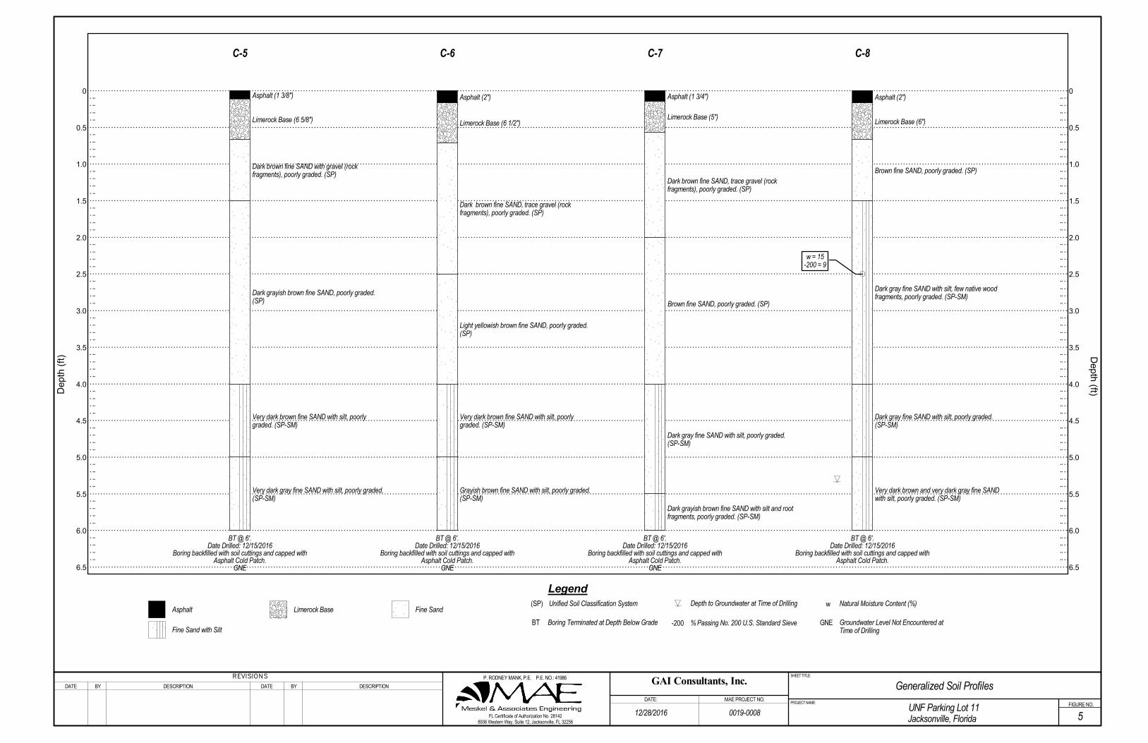
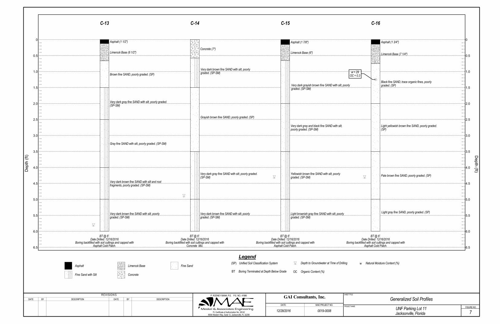
The laboratory test procedures are described in Appendix B. The results of the laboratory testing are shown in the Summary of Laboratory Test Results table included in Appendix B. Also, these results are shown on the Generalized Soil Profiles, Figures 3 through 9, and on the Log of Boring records at the respective depths from which the tested samples were recovered.
4.0 GENERAL PAVEMENT & SUBSURFACE CONDITIONS 4.1 Pavement Core Samples The asphalt portion of the pavement cores was returned to our laboratory to verify the thickness of the asphalt surface as measured in the field, and to observe the overall condition of the asphalt layer. The measured pavement core/base thickness and material descriptions are shown in Table 1.
All of the cores except C-14 encountered an asphalt surface course underlain by what appeared to be a commercially produced limerock material. Core C-14 encountered a concrete wearing surface but no discernible base material. The limerock base material appeared to be relatively dry at the time of our exploration.
Based on our observations of the core samples, the asphalt surface course appeared to be one distinct

University of North Florida (UNF) Lot 11 MAE Report No. 0019-0008
8936 Western Way, Suite 12 Jacksonville, Florida 32256
Phone: (904)519-6990 Fax: (904)519-6992
Page | 3
layer of asphalt containing fine to coarse aggregate. No cracks were observed at top, bottom or sides of the core samples.
4.2 General Soil Profile Graphical presentation of the generalized subsurface conditions is presented on Figures 3 through 9. Detailed boring records are included in Appendix A. When reviewing these records, it should be understood that the soil conditions will vary between the boring locations.
In general, underneath the pavement sections of asphalt and limerock layers as described in section 4.1, the auger and SPT borings encountered fine sands (SP), often underlain by fine sands with silt (SP-SM) to the boring termination depths of 6 feet (C-1 through C-22) and 10 feet (B-1 and B-2) below existing grade. The relative density of the soils encountered at the SPT locations (B-1 and B-2) ranged from medium dense to loose between approximately 1 to 4 feet in depth, and then medium dense to the boring termination depth of 10 feet below existing grade.
4.3 Groundwater Level The groundwater level, where encountered, was recorded at the time of drilling at depths varying from approximately 2 feet 7 inches to 4 feet 8 inches below the existing ground surface. Groundwater was not encountered at pavement core locations C-1 through C-7. However, that does not mean that groundwater does not exist at these locations, nor that groundwater would not be encountered within the vertical reaches of these borings at a later date.
It should be anticipated that the groundwater levels will fluctuate seasonally and with changes in climate. As such, we recommend that the water table be verified prior to construction. Measured groundwater levels are shown on the boring profiles and boring logs.
4.4 USDA Web Soil Survey Data The results of a review of the USDA Soil Conservation Service (SCS) Web Soil Survey of Duval County are shown in the table below. The soil type, drainage class, hydrologic group, and estimated seasonal high groundwater levels reported in the Soil Survey are as follows:
Soil No. Soil Type Drainage Class Hydrologic
Group
Depth to the Water Table(1)
(inches)
22 Evergreen-Wesconnett
Complex(2), Depressional, 0 to 2 percent slopes
Very Poorly Drained A/D 0
32 Leon fine sand, 0 to 2 percent slopes
Poorly Drained A/D 6 to 18
35 Lynn Haven fine sand, 0 to 2 percent slopes
Poorly Drained A/D 0 to 6
(1) The “Water table” above refers to a saturated zone in the soil which occurs during specified months, typically the summer wet season. Estimates of the upper limit shown in the Web Soil Survey are based mainly on observations of the water table at selected sites and on evidence of a saturated

University of North Florida (UNF) Lot 11 MAE Report No. 0019-0008
8936 Western Way, Suite 12 Jacksonville, Florida 32256
Phone: (904)519-6990 Fax: (904)519-6992
Page | 4
zone, namely grayish colors (redoximorphic features) in the soil. A saturated zone that lasts for less than a month is not considered a water table. (2) The term “complex”, as defined by the USDA, refers to a map unit consisting of two or more soils or miscellaneous areas in such an intricate pattern or in such small areas that they cannot be shown separately on the map.
4.5 Seasonal High Groundwater Level In estimating the seasonal high groundwater level, a number of factors are taken into consideration including antecedent rainfall, soil redoximorphic features (i.e., soil mottling), stratigraphy (including presence of hydraulically restrictive layers), vegetative indicators, effects of development, and relief points such as drainage ditches, low-lying areas, etc.
Based on our interpretation of the current site conditions, including the boring logs and review of published data, we estimate the seasonal high groundwater levels at the site to be generally 1 to 2 feet above the water levels measured at the time of our field work. It should be noted that this estimate is relative to the depth of the groundwater level at each location where groundwater was encountered. It does not take into account elevation changes across the site as no ground surface elevations were provided. Test locations where no groundwater was encountered are not included in this estimate as environmental factors, such as sudden change in elevation or other external factors, may be affecting the groundwater level at these locations.
It is possible that higher groundwater levels may exceed the estimated seasonal high groundwater level as a result of significant or prolonged rains. Therefore, we recommend that design drawings and specifications account for the possibility of groundwater level variations, and construction planning should be based on the assumption that such variations will occur.
5.0 DESIGN RECOMENDATIONS 5.1 General The following evaluation and recommendations are based on the provided project information as presented in this report, results of the field exploration and laboratory testing performed, and the construction techniques recommended in Section 6.0 below. If the described project conditions are incorrect or changed after this report, or subsurface conditions encountered during construction are different from those reported, MAE should be notified so these recommendations can be re-evaluated and revised, if necessary. We recommend that MAE review the final design plans and earthwork specifications to verify that the recommendations in this report have been properly interpreted and implemented.
5.2 Pavement Considerations Our exploration of the existing pavement area did not encounter any adverse subsurface conditions that may affect pavement performance. Therefore, we consider the subsurface conditions at the site favorable for support of the new asphalt pavement section. Design and construction of the milling and re-surfacing of the existing roadway should follow current City of Jacksonville (COJ) or FDOT specifications. If requested, we can prepare a project-specific pavement design if specific traffic data is provided.

University of North Florida (UNF) Lot 11 MAE Report No. 0019-0008
8936 Western Way, Suite 12 Jacksonville, Florida 32256
Phone: (904)519-6990 Fax: (904)519-6992
Page | 5
5.2.1 Asphalt Wearing Surface The wearing surface should consist of an FDOT Type S-I or Type S-III asphaltic concrete having a minimum Marshall Stability of 1,500 lbs. Specific requirements for Type S asphaltic concrete wearing surface are outlined in the latest edition of the FDOT Standard Specifications for Road and Bridge Construction. After placement and field compaction, core the wearing surface to verify material thickness and to perform laboratory densities. Obtain cores at frequencies of at least one core per 2,500 square feet of placed pavement or a minimum of two cores per day’s production.
5.3 Dumpster Pad Foundation Considerations Based on the results of our exploration, we consider the shallow subsurface conditions adaptable for support of the proposed dumpster pads. We understand current plans include shallow foundations to support the enclosure columns, with the slab constructed as a slab-on-grade. The foundation design recommendations outlined below and the site preparation and earthwork recommendations in Section 6.0below are recommended to improve the foundation subgrade soils and reduce the potential for excessive total and differential settlements.
5.3.1 Bearing Pressure The maximum allowable net soil bearing pressure for use in shallow foundation design should not exceed 2,000 psf. Net bearing pressure is defined as the soil bearing pressure at the foundation bearing level in excess of the natural overburden pressure at that level. The foundations should be designed based on the maximum load that could be imposed by all loading conditions.
5.3.2 Foundation Size The minimum widths recommended for the isolated column footings is 24 inches. Even though the maximum allowable soil bearing pressure may not be achieved, these width recommendations should control the size of the foundations.
5.3.3 Bearing Depth The foundation should bear at a depth of at least 12 inches below the final grades to provide confinement to the bearing level soils. It is recommended that stormwater be diverted away from the building exterior to reduce the possibility of erosion beneath the footings.
5.3.4 Bearing Material The foundations may bear in either the compacted suitable natural soils or compacted structural fill. The bearing level soils, after compaction, should exhibit densities equivalent to 95 percent of the modified Proctor maximum dry density (ASTM D 1557), to a depth of at least one foot below the foundation bearing levels.
5.3.5 Settlement Estimates Post-construction settlements of the structure will be influenced by several interrelated factors, such as (1) subsurface stratification and strength/compressibility characteristics; (2) footing size, bearing level, applied loads, and resulting bearing pressures beneath the foundations; and (3) site preparation and earthwork construction techniques used by the contractor. Our settlement estimates for the planned dumpster pads are based on the use of site preparation/earthwork construction techniques as recommended in Section 6.0 of this report. Any deviation from these
University of North Florida (UNF) Lot 11 MAE Report No. 0019-0008
8936 Western Way, Suite 12 Jacksonville, Florida 32256
Phone: (904)519-6990 Fax: (904)519-6992
Page | 6
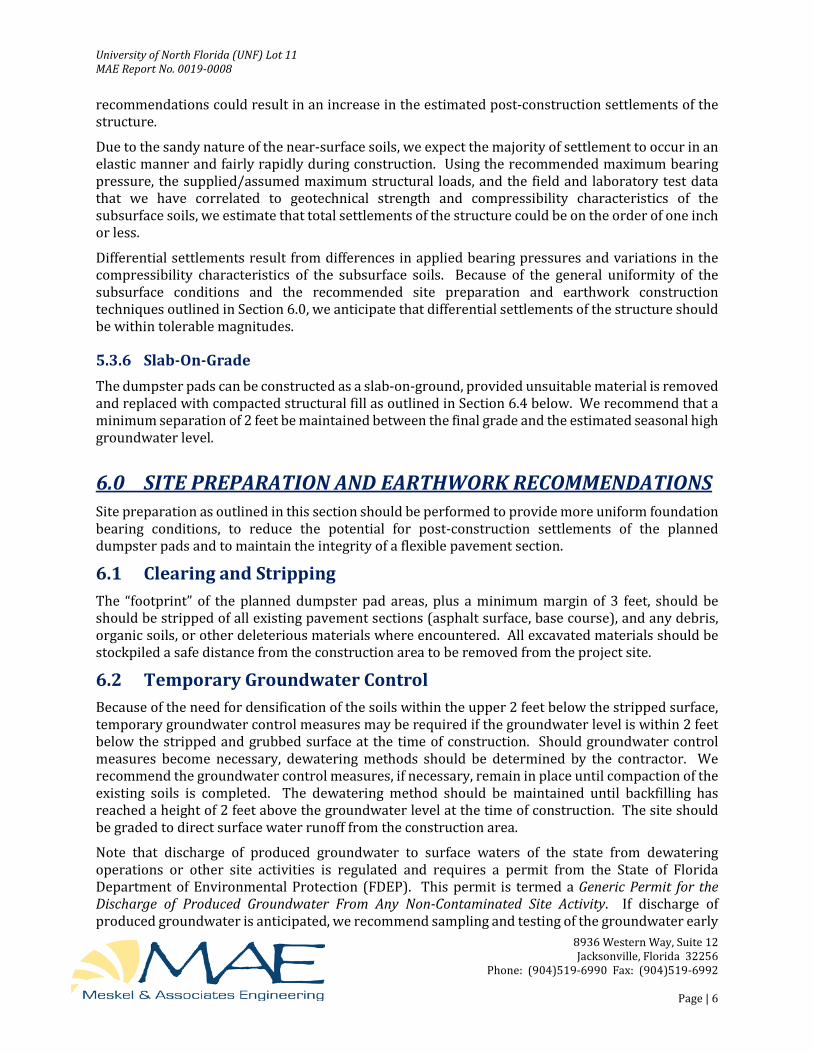
recommendations could result in an increase in the estimated post-construction settlements of the structure.
Due to the sandy nature of the near-surface soils, we expect the majority of settlement to occur in an elastic manner and fairly rapidly during construction. Using the recommended maximum bearing pressure, the supplied/assumed maximum structural loads, and the field and laboratory test data that we have correlated to geotechnical strength and compressibility characteristics of the subsurface soils, we estimate that total settlements of the structure could be on the order of one inch or less.
Differential settlements result from differences in applied bearing pressures and variations in the compressibility characteristics of the subsurface soils. Because of the general uniformity of the subsurface conditions and the recommended site preparation and earthwork construction techniques outlined in Section 6.0, we anticipate that differential settlements of the structure should be within tolerable magnitudes.
5.3.6 Slab-On-Grade The dumpster pads can be constructed as a slab-on-ground, provided unsuitable material is removed and replaced with compacted structural fill as outlined in Section 6.4 below. We recommend that a minimum separation of 2 feet be maintained between the final grade and the estimated seasonal high groundwater level.
6.0 SITE PREPARATION AND EARTHWORK RECOMMENDATIONS Site preparation as outlined in this section should be performed to provide more uniform foundation bearing conditions, to reduce the potential for post-construction settlements of the planned dumpster pads and to maintain the integrity of a flexible pavement section.
6.1 Clearing and Stripping The “footprint” of the planned dumpster pad areas, plus a minimum margin of 3 feet, should be should be stripped of all existing pavement sections (asphalt surface, base course), and any debris, organic soils, or other deleterious materials where encountered. All excavated materials should be stockpiled a safe distance from the construction area to be removed from the project site.
6.2 Temporary Groundwater Control Because of the need for densification of the soils within the upper 2 feet below the stripped surface, temporary groundwater control measures may be required if the groundwater level is within 2 feet below the stripped and grubbed surface at the time of construction. Should groundwater control measures become necessary, dewatering methods should be determined by the contractor. We recommend the groundwater control measures, if necessary, remain in place until compaction of the existing soils is completed. The dewatering method should be maintained until backfilling has reached a height of 2 feet above the groundwater level at the time of construction. The site should be graded to direct surface water runoff from the construction area.
Note that discharge of produced groundwater to surface waters of the state from dewatering operations or other site activities is regulated and requires a permit from the State of Florida Department of Environmental Protection (FDEP). This permit is termed a Generic Permit for the Discharge of Produced Groundwater From Any Non-Contaminated Site Activity. If discharge of produced groundwater is anticipated, we recommend sampling and testing of the groundwater early

University of North Florida (UNF) Lot 11 MAE Report No. 0019-0008
8936 Western Way, Suite 12 Jacksonville, Florida 32256
Phone: (904)519-6990 Fax: (904)519-6992
Page | 7
in the site design phase to prevent project delays during construction. MAE can provide the sampling, testing, and professional consulting required to evaluate compliance with the regulations.
6.3 Compaction After completing the clearing and stripping operations and installing the temporary groundwater control measures (if required), the exposed surface area should be compacted with a vibratory drum roller having a minimum static, at-drum weight, on the order of 5 tons. Typically, the material should exhibit moisture contents within ±2 percent of the modified Proctor optimum moisture content (ASTM D 1557) during the compaction operations. Compaction should continue until densities of at least 95 percent of the modified Proctor maximum dry density (ASTM D 1557) have been achieved within the upper two feet of the compacted natural soils at the site.
Should the bearing level soils experience pumping and soil strength loss during the compaction operations, compaction work should be immediately terminated. The disturbed soils should be removed and backfilled with dry structural fill soils, which are then compacted, or the excess moisture content within the disturbed soils should be allowed to dissipate before recompacting.
Care should be exercised to avoid damaging any nearby structures while the compaction operation is underway. Prior to commencing compaction, occupants of adjacent structures should be notified, and the existing conditions of the structures should be documented with photographs and survey (if deemed necessary). Compaction should cease if deemed detrimental to adjacent structures, and MAE should be contacted immediately. It is recommended that the vibratory roller remain a minimum of 50 feet from existing structures. Within this zone, use of a track-mounted bulldozer or a vibratory roller, operating in the static mode, is recommended.
6.4 Structural Backfill and Fill Soils Any structural fill required for site development should be placed in loose lifts not exceeding 12 inches in thickness and compacted by the use of the above described vibratory drum roller. The lift thickness should be reduced to 8 inches if the roller operates in the static mode or if track-mounted compaction equipment is used. If hand-held compaction equipment is used, the lift thickness should be further reduced to 6 inches.
Structural fill is defined as a non-plastic, inorganic, granular soil having less than 12 percent material passing the No. 200 mesh sieve and containing less than 4 percent organic material. The fine sands and slightly silty fine sands, without roots, as encountered in the borings are suitable as fill materials and, with proper moisture control, should densify using conventional compaction methods. It should be noted that soils with more than 12 percent passing the No. 200 sieve will be more difficult to compact, due to their nature to retain soil moisture, and may require drying. Typically, the material should exhibit moisture contents within ±2 percent of the modified Proctor optimum moisture content (ASTM D 1557) during the compaction operations. Compaction should continue until densities of at least 95 percent of the modified Proctor maximum dry density (ASTM D 1557) have been achieved within each lift of the compacted structural fill.
6.5 Foundation Areas After satisfactory placement and compaction of the required structural fill, the foundation pads for the dumpster enclosure may be excavated to the planned bearing levels. The foundation bearing level soils, after compaction, should exhibit densities equivalent to 95 percent of the modified Proctor maximum dry density (ASTM D 1557), to a depth of one foot below the bearing level. For confined areas, such as the footing excavations, any additional compaction operations can probably best be

University of North Florida (UNF) Lot 11 MAE Report No. 0019-0008
8936 Western Way, Suite 12 Jacksonville, Florida 32256
Phone: (904)519-6990 Fax: (904)519-6992
Page | 8
performed by the use of a lightweight vibratory sled or roller having a total weight on the order of 500 to 2000 pounds.
7.0 QUALITY CONTROL TESTING A representative number of field in-place density tests should be made in the upper 2 feet of compacted natural soils, in each lift of compacted backfill and fill, and in the upper 12 inches below the bearing levels in the dumpster pad footing excavations. The density tests are considered necessary to verify that satisfactory compaction operations have been performed. We recommend density testing be performed in 25 percent of the “footprint” area of each dumpster pad’s construction area.
8.0 REPORT LIMITATIONS This report has been prepared for the exclusive use of GAI Consultants, Inc. for specific application to the planned milling and resurfacing of the UNF Parking Lot 11, and to the design and construction of the planned dumpster pads. A version of our report that is signed and sealed in blue ink may be considered an original of the report. Copies of an original should not be relied on unless specifically allowed by MAE in writing. Our work for this project was performed in accordance with generally accepted geotechnical engineering practice. No warranty, express or implied, is made.
The analyses and recommendations contained in this report are based on the data obtained from the borings performed for this project. This testing indicates subsurface conditions only at the specific locations and times, and only to the depths explored. These results do not reflect subsurface variations that may exist away from the boring locations and/or at depths below the boring termination depths. Subsurface conditions and water levels at other locations may differ from conditions occurring at the tested locations. In addition, it should be understood that the passage of time may result in a change in the conditions at the tested locations. If variations in subsurface conditions from those described in this report are observed during construction, the recommendations in this report must be re-evaluated.
The scope of our services did not include any environmental assessment or testing for the presence or absence of hazardous or toxic materials in the soil, groundwater, or surface water within or beyond the subject site. Any statements made in this report, and/or notations made on the generalized soil profiles or boring logs, regarding odors or other potential environmental concerns are based on observations made during execution of our scope of services and as such are strictly for the information of our client. No opinion of any environmental concern of such observations is made or implied. Unless complete environmental information regarding the site is already available, an environmental assessment is recommended.
If changes in the design or location of the dumpster pad structures occur, the conclusions and recommendations contained in this report may need to be modified. We recommend that these changes be provided to us for our consideration. MAE is not responsible for conclusions, interpretations, opinions or recommendations made by others based on the data contained in this report.

Tables _____________________________________________________________________________________

Thickness (in) Material Thickness
(in) Material
B-1 1 3/8 Ashpalt 6 1/2 Limerock
B-2 2 Ashpalt 6 3/8 Limerock
C-1 1 3/4 Ashpalt 6 1/4 Limerock
C-2 1 1/2 Ashpalt 6 Limerock
C-3 2 Ashpalt 6 Limerock
C-4 1 1/4 Ashpalt 6 1/2 Limerock
C-5 1 3/8 Ashpalt 6 5/8 Limerock
C-6 1 1/2 Ashpalt 6 1/2 Limerock
C-7 1 3/4 Ashpalt 5 Limerock
C-8 2 Ashpalt 6 Limerock
C-9 1 7/8 Ashpalt 6 Limerock
C-10 1 3/4 Ashpalt 6 Limerock
C-11 1 3/4 Ashpalt 6 Limerock
C-12 1 3/4 Ashpalt 6 Limerock
C-13 1 1/2 Ashpalt 6 1/2 Limerock
C-14 7 Concrete N/A N/A
C-15 1 7/8 Ashpalt 6 1/8 Limerock
C-16 1 3/4 Ashpalt 7 1/4 Limerock
C-17 1 5/8 Ashpalt 6 3/8 Limerock
C-18 1 3/4 Ashpalt 6 1/4 Limerock
C-19 1 1/2 Ashpalt 6 1/2 Limerock
C-20 1 1/2 Ashpalt 6 Limerock
C-21 2 1/2 Ashpalt 6 1/2 Limerock
C-22 1 1/2 Ashpalt 7 1/2 Limerock
Base CourseSurface Course
Table 1 - Pavement Core and Base ConditionsUNF Lot 11
MAE Project No. 0019-0008
Core No.

Figures _____________________________________________________________________________________

Site Location Map
PREPARED BY PROJECT NAME
UNF Parking Lot 11 Jacksonville, Florida
REFERENCE SCALE
Delorme XMap 7.0 NTS PREPARED FOR MAE PROJECT NO. FIGURE NO.
GAI Consultants, Inc. 0019-0008 1
Approximate Site
Location
N


0
1
2
3
4
5
6
7
8
9
10
11
0
1
2
3
4
5
6
7
8
9
10
11
Legend
GAI Consultants, Inc.
MAE PROJECT NO.
BY DESCRIPTION DATE BY DESCRIPTION
SHEET TITLE:
PROJECT NAME:
Natural Moisture Content (%)
DATE
0019-0008
% Passing No. 200 U.S. Standard SieveDepth to Groundwater at Time of Drilling
N
FIGURE NO.
Generalized Soil Profiles
3
Depth (ft)D
epth
(ft
)
w
BT
DATE:
-200
Standard Penetration Resistance,Blows/Foot
Unified Soil Classification System(SP)Asphalt Limerock Base Fine Sand
Fine Sand with Silt
UNF Parking Lot 11Jacksonville, Florida
Boring Terminated at Depth Below ExistingGrade
FL Certificate of Authorization No. 281428936 Western Way, Suite 12, Jacksonville, FL 32256
OC Organic Content (%)
12/28/2016
BT @ 10'.Date Drilled: 12/14/2016
Boring backfilled with soil cuttings and capped withAsphalt Cold Patch.
10
7
20
21
25
Asphalt (1 3/8")
Limerock Base (6 1/2")
Medium dense, Brown fine SAND, poorly graded.(SP)
Loose, Very dark gray fine SAND, poorly graded.(SP)
Medium dense, Black fine SAND with silt, poorlygraded. (SP-SM)
Medium dense, Dark grayish brown fine SAND,poorly graded. (SP)
Medium dense, Black fine SAND with silt, little rootfragments, little organic fines, poorly graded.(SP-SM)
BT @ 10'.Date Drilled: 12/14/2016
Boring backfilled with soil cuttings and capped withAsphalt Cold Patch.
15
7
17
18
17
Asphalt (2")
Limerock Base (6 3/8")
Medium dense to loose, Very pale brown fineSAND, poorly graded. (SP)
Medium dense, Light gray fine SAND, poorlygraded. (SP)
N
B-1
N
B-2
P. RODNEY MANK, P.E. P.E. NO.: 41986
w = 30OC = 5.5
w = 22-200 = 2
w = 26-200 = 3

0
0.5
1.0
1.5
2.0
2.5
3.0
3.5
4.0
4.5
5.0
5.5
6.0
6.5
0
0.5
1.0
1.5
2.0
2.5
3.0
3.5
4.0
4.5
5.0
5.5
6.0
6.5
BY DESCRIPTION DATE BY DESCRIPTION
SHEET TITLE:
PROJECT NAME:
DATE
0019-0008FIGURE NO.
Generalized Soil Profiles
4
Depth (ft)D
epth
(ft
)
BT
(SP)Asphalt Limerock Base Fine Sand
Fine Sand with Silt
DATE:
Legend
GAI Consultants, Inc.
MAE PROJECT NO.
Unified Soil Classification System Depth to Groundwater at Time of Drilling
UNF Parking Lot 11Jacksonville, Florida
Boring Terminated at Depth Below Grade
FL Certificate of Authorization No. 281428936 Western Way, Suite 12, Jacksonville, FL 32256
GNE Groundwater Level Not Encountered atTime of Drilling
Asphalt (1 3/4")
Limerock Base (6 1/4")
Brown fine SAND, some gravel (rock fragments),poorly graded. (SP)
Brown fine SAND with silt, poorly graded. (SP-SM)
Gray fine SAND, poorly graded. (SP)
BT @ 6'.Date Drilled: 12/15/2016
Boring backfilled with soil cuttings and capped withAsphalt Cold Patch.
GNE
Asphalt (1 1/2")
Limerock Base (6")
Dark brown fine SAND, poorly graded. (SP)
Light yellowish brown fine SAND, poorly graded.(SP)
Dark yellowish brown fine SAND with silt, poorlygraded. (SP-SM)
Dark gray fine SAND with silt, poorly graded.(SP-SM)
Very dark gray fine SAND with silt, poorly graded.(SP-SM)
BT @ 6'.Date Drilled: 12/15/2016
Boring backfilled with soil cuttings and capped withAsphalt Cold Patch.
GNE
Limerock Base (6")
Brown fine SAND with gravel (rock fragments),poorly graded. (SP)
Asphalt (2")
Very dark brown fine SAND with silt, poorlygraded. (SP-SM)
Very dark gray fine SAND with silt, poorly graded.(SP-SM)
BT @ 6'.Date Drilled: 12/15/2016
Boring backfilled with soil cuttings and capped withAsphalt Cold Patch.
GNE
BT @ 6'.Date Drilled: 12/15/2016
Boring backfilled with soil cuttings and capped withAsphalt Cold Patch.
GNE
Black fine SAND with silt, poorly graded. (SP-SM)
Asphalt (1 1/4")
Limerock Base (6 3/4")
Very dark brown fine SAND, poorly graded. (SP)
Very dark brown fine SAND with gravel (rockfragments), poorly graded. (SP)
Grayish brown fine SAND with silt, poorly graded.(SP-SM)
12/28/2016
C-1 C-2 C-3 C-4
P. RODNEY MANK, P.E. P.E. NO.: 41986
0
0.5
1.0
1.5
2.0
2.5
3.0
3.5
4.0
4.5
5.0
5.5
6.0
6.5
0
0.5
1.0
1.5
2.0
2.5
3.0
3.5
4.0
4.5
5.0
5.5
6.0
6.5
BY DESCRIPTION DATE BY DESCRIPTION
SHEET TITLE:
PROJECT NAME:
Natural Moisture Content (%)
DATE
0019-0008FIGURE NO.
Generalized Soil Profiles
5
Depth (ft)D
epth
(ft
)
w
BT
(SP)Asphalt Limerock Base Fine Sand
Fine Sand with Silt
DATE:
Legend
GAI Consultants, Inc.
MAE PROJECT NO.
Unified Soil Classification System Depth to Groundwater at Time of Drilling
-200 % Passing No. 200 U.S. Standard Sieve
UNF Parking Lot 11Jacksonville, Florida
Boring Terminated at Depth Below Grade
FL Certificate of Authorization No. 281428936 Western Way, Suite 12, Jacksonville, FL 32256
GNE Groundwater Level Not Encountered atTime of Drilling
Asphalt (1 3/8")
Limerock Base (6 5/8")
Dark brown fine SAND with gravel (rockfragments), poorly graded. (SP)
Dark grayish brown fine SAND, poorly graded.(SP)
Very dark brown fine SAND with silt, poorlygraded. (SP-SM)
Very dark gray fine SAND with silt, poorly graded.(SP-SM)
BT @ 6'.Date Drilled: 12/15/2016
Boring backfilled with soil cuttings and capped withAsphalt Cold Patch.
GNE
Asphalt (2")
Limerock Base (6 1/2")
Dark brown fine SAND, trace gravel (rockfragments), poorly graded. (SP)
Light yellowish brown fine SAND, poorly graded.(SP)
Very dark brown fine SAND with silt, poorlygraded. (SP-SM)
Grayish brown fine SAND with silt, poorly graded.(SP-SM)
BT @ 6'.Date Drilled: 12/15/2016
Boring backfilled with soil cuttings and capped withAsphalt Cold Patch.
GNE
Asphalt (1 3/4")
Limerock Base (5")
Dark brown fine SAND, trace gravel (rockfragments), poorly graded. (SP)
Dark gray fine SAND with silt, poorly graded.(SP-SM)
Dark grayish brown fine SAND with silt and rootfragments, poorly graded. (SP-SM)
Brown fine SAND, poorly graded. (SP)
BT @ 6'.Date Drilled: 12/15/2016
Boring backfilled with soil cuttings and capped withAsphalt Cold Patch.
GNE
Asphalt (2")
Limerock Base (6")
Brown fine SAND, poorly graded. (SP)
Dark gray fine SAND with silt, few native woodfragments, poorly graded. (SP-SM)
Dark gray fine SAND with silt, poorly graded.(SP-SM)
Very dark brown and very dark gray fine SANDwith silt, poorly graded. (SP-SM)
BT @ 6'.Date Drilled: 12/15/2016
Boring backfilled with soil cuttings and capped withAsphalt Cold Patch.
12/28/2016
C-5 C-6 C-7 C-8
P. RODNEY MANK, P.E. P.E. NO.: 41986
w = 15-200 = 9

0
0.5
1.0
1.5
2.0
2.5
3.0
3.5
4.0
4.5
5.0
5.5
6.0
6.5
0
0.5
1.0
1.5
2.0
2.5
3.0
3.5
4.0
4.5
5.0
5.5
6.0
6.5
BY DESCRIPTION DATE BY DESCRIPTION
SHEET TITLE:
PROJECT NAME:
Natural Moisture Content (%)
DATE
0019-0008FIGURE NO.
Generalized Soil Profiles
6
Depth (ft)D
epth
(ft
)
w
BT
(SP)Asphalt Limerock Base Fine Sand
Fine Sand with Silt
DATE:
Legend
GAI Consultants, Inc.
MAE PROJECT NO.
Unified Soil Classification System Depth to Groundwater at Time of Drilling
-200 % Passing No. 200 U.S. Standard Sieve
UNF Parking Lot 11Jacksonville, Florida
Boring Terminated at Depth Below Grade
FL Certificate of Authorization No. 281428936 Western Way, Suite 12, Jacksonville, FL 32256
Asphalt (1 3/4")
Limerock Base (6")
Dark grayish brown fine SAND, poorly graded.(SP)
Brown fine SAND, poorly graded. (SP)
Dark gray and black fine SAND, poorly graded.(SP)
Very dark brown fine SAND with silt, poorlygraded. (SP-SM)
Dark grayish brown fine SAND with silt, poorlygraded. (SP-SM)
BT @ 6'.Date Drilled: 12/16/2016
Boring backfilled with soil cuttings and capped withAsphalt Cold Patch.
BT @ 6'.Date Drilled: 12/16/2016
Boring backfilled with soil cuttings and capped withAsphalt Cold Patch.
Asphalt (1 3/4")
Limerock Base (6")
Brown fine SAND, poorly graded. (SP)
Very dark gray fine SAND with silt, poorly graded.(SP-SM)
Very dark grayish brown fine SAND with silt, poorlygraded. (SP-SM)
Gray fine SAND, poorly graded. (SP)
Black fine SAND with silt, poorly graded. (SP-SM)
Asphalt (1 3/4")
BT @ 6'.Date Drilled: 12/16/2016
Boring backfilled with soil cuttings and capped withAsphalt Cold Patch.
Limerock Base (6")
Brown fine SAND, poorly graded. (SP)
Black fine SAND with silt, poorly graded. (SP-SM)
Grayish brown fine SAND with silt, poorly graded.(SP-SM)
Very dark brown fine SAND with silt, poorlygraded. (SP-SM)
BT @ 6'.Date Drilled: 12/15/2016
Boring backfilled with soil cuttings and capped withAsphalt Cold Patch.
Asphalt (1 7/8")
Limerock Base (6")
Very dark brown fine SAND, poorly graded. (SP)
Light brownish gray fine SAND, poorly graded.(SP)
Very dark gray fine SAND, poorly graded. (SP)
Very dark grayish brown fine SAND, poorlygraded. (SP)
Grayish brown fine SAND, poorly graded. (SP)
Light gray fine SAND, poorly graded. (SP)
12/28/2016
C-10 C-11 C-12C-9
P. RODNEY MANK, P.E. P.E. NO.: 41986
w = 13-200 = 7
0
0.5
1.0
1.5
2.0
2.5
3.0
3.5
4.0
4.5
5.0
5.5
6.0
6.5
0
0.5
1.0
1.5
2.0
2.5
3.0
3.5
4.0
4.5
5.0
5.5
6.0
6.5
BY DESCRIPTION DATE BY DESCRIPTION
SHEET TITLE:
PROJECT NAME:
Natural Moisture Content (%)
DATE
0019-0008FIGURE NO.
7
Depth (ft)D
epth
(ft
)
w
BT
(SP)Asphalt Limerock Base Fine Sand
Fine Sand with Silt Concrete
DATE:
Legend
GAI Consultants, Inc.
MAE PROJECT NO.
Unified Soil Classification System Depth to Groundwater at Time of Drilling
UNF Parking Lot 11Jacksonville, Florida
Boring Terminated at Depth Below Grade Organic Content (%)
FL Certificate of Authorization No. 281428936 Western Way, Suite 12, Jacksonville, FL 32256
OC
BT @ 6'.Date Drilled: 12/16/2016
Boring backfilled with soil cuttings and capped withAsphalt Cold Patch.
Asphalt (1 1/2")
Limerock Base (6 1/2")
Brown fine SAND, poorly graded. (SP)
Very dark gray fine SAND with silt, poorly graded.(SP-SM)
Gray fine SAND with silt, poorly graded. (SP-SM)
Very dark brown fine SAND with silt and rootfragments, poorly graded. (SP-SM)
Very dark brown fine SAND with silt, poorlygraded. (SP-SM)
Concrete (7")
Very dark gray fine SAND with silt, poorly graded.(SP-SM)
Very dark brown fine SAND with silt, poorlygraded. (SP-SM)
Grayish brown fine SAND, poorly graded. (SP)
BT @ 6'.Date Drilled: 12/16/2016
Boring backfilled with soil cuttings and capped withConcrete Mix.
Very dark brown fine SAND with silt, poorlygraded. (SP-SM)
Asphalt (1 7/8")
Limerock Base (6")
Very dark gray and black fine SAND with silt,poorly graded. (SP-SM)
Yellowish brown fine SAND with silt, poorlygraded. (SP-SM)
Light brownish gray fine SAND with silt, poorlygraded. (SP-SM)
Very dark grayish brown fine SAND with silt, poorlygraded. (SP-SM)
BT @ 6'.Date Drilled: 12/16/2016
Boring backfilled with soil cuttings and capped withAsphalt Cold Patch.
Light gray fine SAND, poorly graded. (SP)
BT @ 6'.Date Drilled: 12/16/2016
Boring backfilled with soil cuttings and capped withAsphalt Cold Patch.
Asphalt (1 3/4")
Limerock Base (7 1/4")
Black fine SAND, trace organic fines, poorlygraded. (SP)
Light yellowish brown fine SAND, poorly graded.(SP)
Pale brown fine SAND, poorly graded. (SP)
12/28/2016
Generalized Soil Profiles
C-13 C-14 C-15 C-16
P. RODNEY MANK, P.E. P.E. NO.: 41986
w = 29OC = 0.3

0
0.5
1.0
1.5
2.0
2.5
3.0
3.5
4.0
4.5
5.0
5.5
6.0
6.5
0
0.5
1.0
1.5
2.0
2.5
3.0
3.5
4.0
4.5
5.0
5.5
6.0
6.5
BY DESCRIPTION DATE BY DESCRIPTION
SHEET TITLE:
PROJECT NAME:
Natural Moisture Content (%)
DATE
0019-0008FIGURE NO.
Generalized Soil Profiles
8
Depth (ft)D
epth
(ft
)
w
BT
(SP)Asphalt Limerock Base Fine Sand with Silt
Fine Sand
DATE:
Legend
GAI Consultants, Inc.
MAE PROJECT NO.
Unified Soil Classification System Depth to Groundwater at Time of Drilling
-200 % Passing No. 200 U.S. Standard Sieve
UNF Parking Lot 11Jacksonville, Florida
Boring Terminated at Depth Below Grade
FL Certificate of Authorization No. 281428936 Western Way, Suite 12, Jacksonville, FL 32256
Asphalt (1 5/8")
Limerock Base (6 3/8")
Light yellowish brown fine SAND with silt, poorlygraded. (SP-SM)
Very pale brown fine SAND with silt, poorlygraded. (SP-SM)
White fine SAND, poorly graded. (SP)
Grayish brown fine SAND with silt and gravel (rockfragments), poorly graded. (SP-SM)
BT @ 6'.Date Drilled: 12/16/2016
Boring backfilled with soil cuttings and capped withAsphalt Cold Patch.
BT @ 6'.Date Drilled: 12/16/2016
Boring backfilled with soil cuttings and capped withAsphalt Cold Patch.
Asphalt (1 3/4")
Limerock Base (6 1/4")
Pale brown fine SAND, poorly graded. (SP)
Light gray fine SAND, poorly graded. (SP)
Very pale brown fine SAND, poorly graded. (SP)
Brown fine SAND with silt, gravel (rock fragments)and bricks, poorly graded. (SP-SM)
BT @ 6'.Date Drilled: 12/16/2016
Boring backfilled with soil cuttings and capped withAsphalt Cold Patch.
Asphalt (1 1/2")
Limerock Base (6 1/2")
Grayish brown fine SAND, some gravel (rockfragments), poorly graded. (SP)
Pale brown fine SAND, poorly graded. (SP)
Very pale brown fine SAND, poorly graded. (SP)
BT @ 6'.Date Drilled: 12/16/2016
Boring backfilled with soil cuttings and capped withAsphalt Cold Patch.
Asphalt (1 1/2")
Limerock Base (6")
Very dark grayish brown fine SAND with silt, poorlygraded. (SP-SM)
Grayish brown fine SAND, few gravel (rockfragments), poorly graded. (SP)
Gray fine SAND with silt, trace gravel (rockfragments), poorly graded. (SP-SM)
Dark brown fine SAND with silt, poorly graded.(SP-SM)
Grayish brown fine SAND with silt, poorly graded.(SP-SM)
12/28/2016
C-17 C-18 C-19 C-20
P. RODNEY MANK, P.E. P.E. NO.: 41986

0
0.5
1.0
1.5
2.0
2.5
3.0
3.5
4.0
4.5
5.0
5.5
6.0
6.5
0
0.5
1.0
1.5
2.0
2.5
3.0
3.5
4.0
4.5
5.0
5.5
6.0
6.5
BY DESCRIPTION DATE BY DESCRIPTION
SHEET TITLE:
PROJECT NAME:
Natural Moisture Content (%)
DATE
0019-0008FIGURE NO.
Generalized Soil Profiles
9
Depth (ft)
OC
Dep
th (
ft)
w
BT
(SP)Asphalt Limerock Base Fine Sand
Fine Sand with Silt
DATE:
Legend
GAI Consultants, Inc.
MAE PROJECT NO.
Unified Soil Classification System Depth to Groundwater at Time of Drilling
UNF Parking Lot 11Jacksonville, Florida
Boring Terminated at Depth Below Grade
FL Certificate of Authorization No. 28142
Organic Content (%)
8936 Western Way, Suite 12, Jacksonville, FL 32256
BT @ 6'.Date Drilled: 12/16/2016
Boring backfilled with soil cuttings and capped withAsphalt Cold Patch.
Asphalt (2 1/2")
Very dark brown fine SAND, poorly graded. (SP)
Grayish brown fine SAND with silt, trace gravel(rock fragments), poorly graded. (SP-SM)
Light gray fine SAND, poorly graded. (SP)
Limerock Base (6 1/2")
BT @ 6'.Date Drilled: 12/16/2016
Boring backfilled with soil cuttings and capped withAsphalt Cold Patch.
Asphalt (1 1/2")
Limerock Base (7 1/2")
Dark brown fine SAND, poorly graded. (SP)
Grayish brown fine SAND with silt, poorly graded.(SP-SM)
Black fine SAND with silt, trace organic fines,poorly graded. (SP-SM)
Very dark brown fine SAND with silt, few organicfines, poorly graded (SP-SM)
12/28/2016
C-21 C-22
P. RODNEY MANK, P.E. P.E. NO.: 41986
w = 39OC = 3.8

Appendix A _____________________________________________________________________________________

26 3
Asphalt (1 3/8")Limerock Base (6 1/2")
Medium dense, Brown fine SAND, poorly graded.
Loose, Very dark gray fine SAND, poorly graded.
Medium dense, Dark grayish brown fine SAND,poorly graded.
Medium dense, Black fine SAND with silt, poorlygraded.
10
7
20
21
25
864
2344
510106
5101113
5101518
1
2
3
4
5
SP
SP
SP
SP-SM
SP-SM
COMPLETED 12/14/16DATE STARTED 12/14/16
DRILLING CONTRACTOR MAE, PLLC
LOGGED BY P.R.Young CHECKED BY W. Josh Mele GROUND ELEVATION
DRILLING METHOD Standard Penetration Test
BORING LOCATION See Boring Location Plan
MO
IST
UR
EC
ON
TE
NT
(%
)
PLA
ST
ICIT
YIN
DE
X
GR
AP
HIC
LOG
N-V
ALU
E
BLO
W C
OU
NT
S
REMARKS
SA
MP
LE D
EP
TH
NU
MB
ER
PO
CK
ET
PE
N.
(tsf
)R
EC
OV
ER
Y %
(RQ
D)
FIN
ES
CO
NT
EN
T (
%)
LIQ
UID
LIM
IT
MATERIAL DESCRIPTION
DE
PT
H (
ft)
0.0
2.5
5.0
7.5
10.0
OR
GA
NIC
CO
NT
EN
T (
%)
US
CS
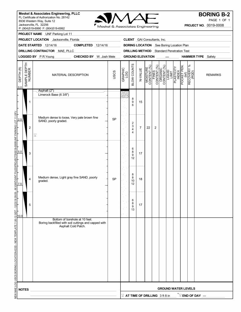
BORING B-1PAGE 1 OF 1
NOTES GROUND WATER LEVELS
END OF DAY ---
PROJECT NAME UNF Parking Lot 11
PROJECT LOCATION Jacksonville, Florida CLIENT GAI Consultants, Inc.
PROJECT NO. 0019-0008
NE
W M
AE
LO
G U
SC
S B
OR
ING
LO
CA
TIO
N-E
OD
- N
EW
TE
MP
LAT
E 7
-30-
12.G
DT
- 1
2/23
/16
09:
09 -
M:\G
INT
\GIN
T F
ILE
S\P
RO
JEC
TS
\001
9-0
008\
UN
F P
AR
KIN
G L
OT
11.
GP
JMeskel & Associates Engineering, PLLCFL Certificate of Authorization No. 281428936 Western Way, Suite 12Jacksonville, FL 32256P: (904)519-6990 F: (904)519-6992
AT TIME OF DRILLING 4 ft 8 in
Bottom of borehole at 10 feet.Boring backfilled with soil cuttings and capped with
Asphalt Cold Patch.
30 5.5Medium dense, Black fine SAND with silt, little rootfragments, little organic fines, poorly graded.
HAMMER TYPE Safety
22
15
7
17
18
17
896
2344
68912
881012
68913
1
2
3
4
5
2
Asphalt (2")Limerock Base (6 3/8")
Medium dense to loose, Very pale brown fineSAND, poorly graded.
Medium dense, Light gray fine SAND, poorlygraded.
SP
SP
COMPLETED 12/14/16DATE STARTED 12/14/16
DRILLING CONTRACTOR MAE, PLLC
LOGGED BY P.R.Young CHECKED BY W. Josh Mele GROUND ELEVATION
DRILLING METHOD Standard Penetration Test
BORING LOCATION See Boring Location Plan
MO
IST
UR
EC
ON
TE
NT
(%
)
PLA
ST
ICIT
YIN
DE
X
GR
AP
HIC
LOG
N-V
ALU
E
BLO
W C
OU
NT
S
REMARKS
SA
MP
LE D
EP
TH
NU
MB
ER
PO
CK
ET
PE
N.
(tsf
)R
EC
OV
ER
Y %
(RQ
D)
FIN
ES
CO
NT
EN
T (
%)
LIQ
UID
LIM
IT
MATERIAL DESCRIPTION
DE
PT
H (
ft)
0.0
2.5
5.0
7.5
10.0
OR
GA
NIC
CO
NT
EN
T (
%)
US
CS
BORING B-2PAGE 1 OF 1
NOTES GROUND WATER LEVELS
END OF DAY ---
PROJECT NAME UNF Parking Lot 11
PROJECT LOCATION Jacksonville, Florida CLIENT GAI Consultants, Inc.
PROJECT NO. 0019-0008
NE
W M
AE
LO
G U
SC
S B
OR
ING
LO
CA
TIO
N-E
OD
- N
EW
TE
MP
LAT
E 7
-30-
12.G
DT
- 1
2/23
/16
09:
09 -
M:\G
INT
\GIN
T F
ILE
S\P
RO
JEC
TS
\001
9-0
008\
UN
F P
AR
KIN
G L
OT
11.
GP
JMeskel & Associates Engineering, PLLCFL Certificate of Authorization No. 281428936 Western Way, Suite 12Jacksonville, FL 32256P: (904)519-6990 F: (904)519-6992
AT TIME OF DRILLING 3 ft 8 in
Bottom of borehole at 10 feet.Boring backfilled with soil cuttings and capped with
Asphalt Cold Patch.
HAMMER TYPE Safety
1
2
3
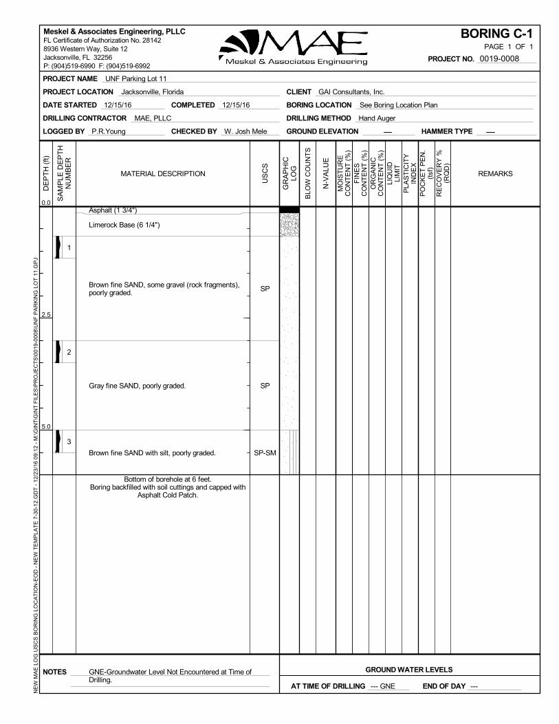
Asphalt (1 3/4")
Limerock Base (6 1/4")
Brown fine SAND, some gravel (rock fragments),poorly graded.
Gray fine SAND, poorly graded.
Brown fine SAND with silt, poorly graded.
SP
SP
SP-SM
COMPLETED 12/15/16
GNE-Groundwater Level Not Encountered at Time ofDrilling.
DATE STARTED 12/15/16
DRILLING CONTRACTOR MAE, PLLC
LOGGED BY P.R.Young CHECKED BY W. Josh Mele GROUND ELEVATION HAMMER TYPE
DRILLING METHOD Hand Auger
BORING LOCATION See Boring Location Plan
MO
IST
UR
EC
ON
TE
NT
(%
)
PLA
ST
ICIT
YIN
DE
X
GR
AP
HIC
LOG
N-V
ALU
E
BLO
W C
OU
NT
S
REMARKS
SA
MP
LE D
EP
TH
NU
MB
ER
PO
CK
ET
PE
N.
(tsf
)R
EC
OV
ER
Y %
(RQ
D)
FIN
ES
CO
NT
EN
T (
%)
LIQ
UID
LIM
IT
MATERIAL DESCRIPTION
DE
PT
H (
ft)
0.0
2.5
5.0
OR
GA
NIC
CO
NT
EN
T (
%)
US
CS
BORING C-1PAGE 1 OF 1
NOTES GROUND WATER LEVELS
END OF DAY ---AT TIME OF DRILLING --- GNE
PROJECT NAME UNF Parking Lot 11
PROJECT LOCATION Jacksonville, Florida CLIENT GAI Consultants, Inc.
PROJECT NO. 0019-0008
NE
W M
AE
LO
G U
SC
S B
OR
ING
LO
CA
TIO
N-E
OD
- N
EW
TE
MP
LAT
E 7
-30-
12.G
DT
- 1
2/23
/16
09:
12 -
M:\G
INT
\GIN
T F
ILE
S\P
RO
JEC
TS
\001
9-0
008\
UN
F P
AR
KIN
G L
OT
11.
GP
JMeskel & Associates Engineering, PLLCFL Certificate of Authorization No. 281428936 Western Way, Suite 12Jacksonville, FL 32256P: (904)519-6990 F: (904)519-6992
Bottom of borehole at 6 feet.Boring backfilled with soil cuttings and capped with
Asphalt Cold Patch.

BORING C-2PAGE 1 OF 1
NOTES GROUND WATER LEVELS
END OF DAY ---AT TIME OF DRILLING --- GNE
1
2
3
4
5
Asphalt (1 1/2")
Limerock Base (6")
Dark brown fine SAND, poorly graded.
Light yellowish brown fine SAND, poorly graded.
Dark yellowish brown fine SAND with silt, poorlygraded.
Dark gray fine SAND with silt, poorly graded.
Very dark gray fine SAND with silt, poorly graded.
SP
SP
SP-SM
SP-SM
SP-SM
COMPLETED 12/15/16DATE STARTED 12/15/16
DRILLING CONTRACTOR MAE, PLLC
LOGGED BY P.R.Young CHECKED BY W. Josh Mele GROUND ELEVATION HAMMER TYPE
DRILLING METHOD Hand Auger
BORING LOCATION See Boring Location Plan
MO
IST
UR
EC
ON
TE
NT
(%
)
PLA
ST
ICIT
YIN
DE
X
GR
AP
HIC
LOG
N-V
ALU
E
BLO
W C
OU
NT
S
REMARKS
SA
MP
LE D
EP
TH
NU
MB
ER
PO
CK
ET
PE
N.
(tsf
)R
EC
OV
ER
Y %
(RQ
D)
FIN
ES
CO
NT
EN
T (
%)
LIQ
UID
LIM
IT
MATERIAL DESCRIPTION
DE
PT
H (
ft)
0.0
2.5
5.0
OR
GA
NIC
CO
NT
EN
T (
%)
US
CS
PROJECT NAME UNF Parking Lot 11
PROJECT LOCATION Jacksonville, Florida CLIENT GAI Consultants, Inc.
PROJECT NO. 0019-0008
NE
W M
AE
LO
G U
SC
S B
OR
ING
LO
CA
TIO
N-E
OD
- N
EW
TE
MP
LAT
E 7
-30-
12.G
DT
- 1
2/23
/16
09:
12 -
M:\G
INT
\GIN
T F
ILE
S\P
RO
JEC
TS
\001
9-0
008\
UN
F P
AR
KIN
G L
OT
11.
GP
JMeskel & Associates Engineering, PLLCFL Certificate of Authorization No. 281428936 Western Way, Suite 12Jacksonville, FL 32256P: (904)519-6990 F: (904)519-6992
Bottom of borehole at 6 feet.Boring backfilled with soil cuttings and capped with
Asphalt Cold Patch.
GNE-Groundwater Level Not Encountered at Time ofDrilling.

1
2
3
Asphalt (2")
Limerock Base (6")
Brown fine SAND with gravel (rock fragments),poorly graded.
Very dark brown fine SAND with silt, poorly graded.
Very dark gray fine SAND with silt, poorly graded.
SP
SP-SM
SP-SM
COMPLETED 12/15/16DATE STARTED 12/15/16
DRILLING CONTRACTOR MAE, PLLC
LOGGED BY P.R.Young CHECKED BY W. Josh Mele GROUND ELEVATION HAMMER TYPE
DRILLING METHOD Hand Auger
BORING LOCATION See Boring Location Plan
MO
IST
UR
EC
ON
TE
NT
(%
)
PLA
ST
ICIT
YIN
DE
X
GR
AP
HIC
LOG
N-V
ALU
E
BLO
W C
OU
NT
S
REMARKS
SA
MP
LE D
EP
TH
NU
MB
ER
PO
CK
ET
PE
N.
(tsf
)R
EC
OV
ER
Y %
(RQ
D)
FIN
ES
CO
NT
EN
T (
%)
LIQ
UID
LIM
IT
MATERIAL DESCRIPTION
DE
PT
H (
ft)
0.0
2.5
5.0
OR
GA
NIC
CO
NT
EN
T (
%)
US
CS
BORING C-3PAGE 1 OF 1
NOTES GROUND WATER LEVELS
END OF DAY ---AT TIME OF DRILLING --- GNE
PROJECT NAME UNF Parking Lot 11
PROJECT LOCATION Jacksonville, Florida CLIENT GAI Consultants, Inc.
PROJECT NO. 0019-0008
NE
W M
AE
LO
G U
SC
S B
OR
ING
LO
CA
TIO
N-E
OD
- N
EW
TE
MP
LAT
E 7
-30-
12.G
DT
- 1
2/23
/16
09:
12 -
M:\G
INT
\GIN
T F
ILE
S\P
RO
JEC
TS
\001
9-0
008\
UN
F P
AR
KIN
G L
OT
11.
GP
JMeskel & Associates Engineering, PLLCFL Certificate of Authorization No. 281428936 Western Way, Suite 12Jacksonville, FL 32256P: (904)519-6990 F: (904)519-6992
Bottom of borehole at 6 feet.Boring backfilled with soil cuttings and capped with
Asphalt Cold Patch.
GNE-Groundwater Level Not Encountered at Time ofDrilling.

1
2
3
4
Asphalt (1 1/4")
Limerock Base (6 3/4")
Very dark brown fine SAND, poorly graded.
Very dark brown fine SAND with gravel (rockfragments), poorly graded.
Black fine SAND with silt, poorly graded.
Grayish brown fine SAND with silt, poorly graded.
SP
SP
SP-SM
SP-SM
COMPLETED 12/15/16DATE STARTED 12/15/16
DRILLING CONTRACTOR MAE, PLLC
LOGGED BY P.R.Young CHECKED BY W. Josh Mele GROUND ELEVATION HAMMER TYPE
DRILLING METHOD Hand Auger
BORING LOCATION See Boring Location Plan
MO
IST
UR
EC
ON
TE
NT
(%
)
PLA
ST
ICIT
YIN
DE
X
GR
AP
HIC
LOG
N-V
ALU
E
BLO
W C
OU
NT
S
REMARKS
SA
MP
LE D
EP
TH
NU
MB
ER
PO
CK
ET
PE
N.
(tsf
)R
EC
OV
ER
Y %
(RQ
D)
FIN
ES
CO
NT
EN
T (
%)
LIQ
UID
LIM
IT
MATERIAL DESCRIPTION
DE
PT
H (
ft)
0.0
2.5
5.0
OR
GA
NIC
CO
NT
EN
T (
%)
US
CS
BORING C-4PAGE 1 OF 1
NOTES GROUND WATER LEVELS
END OF DAY ---AT TIME OF DRILLING --- GNE
PROJECT NAME UNF Parking Lot 11
PROJECT LOCATION Jacksonville, Florida CLIENT GAI Consultants, Inc.
PROJECT NO. 0019-0008
NE
W M
AE
LO
G U
SC
S B
OR
ING
LO
CA
TIO
N-E
OD
- N
EW
TE
MP
LAT
E 7
-30-
12.G
DT
- 1
2/23
/16
09:
12 -
M:\G
INT
\GIN
T F
ILE
S\P
RO
JEC
TS
\001
9-0
008\
UN
F P
AR
KIN
G L
OT
11.
GP
JMeskel & Associates Engineering, PLLCFL Certificate of Authorization No. 281428936 Western Way, Suite 12Jacksonville, FL 32256P: (904)519-6990 F: (904)519-6992
GNE-Groundwater Level Not Encountered at Time ofDrilling.
Bottom of borehole at 6 feet.Boring backfilled with soil cuttings and capped with
Asphalt Cold Patch.
1
2
3
4
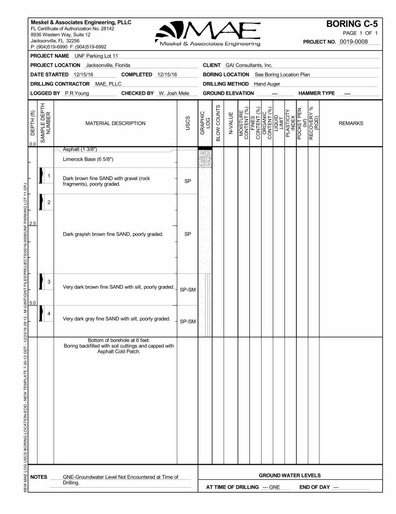
Asphalt (1 3/8")
Limerock Base (6 5/8")
Dark brown fine SAND with gravel (rockfragments), poorly graded.
Dark grayish brown fine SAND, poorly graded.
Very dark brown fine SAND with silt, poorly graded.
Very dark gray fine SAND with silt, poorly graded.
SP
SP
SP-SM
SP-SM
COMPLETED 12/15/16DATE STARTED 12/15/16
DRILLING CONTRACTOR MAE, PLLC
LOGGED BY P.R.Young CHECKED BY W. Josh Mele GROUND ELEVATION HAMMER TYPE
DRILLING METHOD Hand Auger
BORING LOCATION See Boring Location Plan
MO
IST
UR
EC
ON
TE
NT
(%
)
PLA
ST
ICIT
YIN
DE
X
GR
AP
HIC
LOG
N-V
ALU
E
BLO
W C
OU
NT
S
REMARKS
SA
MP
LE D
EP
TH
NU
MB
ER
PO
CK
ET
PE
N.
(tsf
)R
EC
OV
ER
Y %
(RQ
D)
FIN
ES
CO
NT
EN
T (
%)
LIQ
UID
LIM
IT
MATERIAL DESCRIPTION
DE
PT
H (
ft)
0.0
2.5
5.0
OR
GA
NIC
CO
NT
EN
T (
%)
US
CS
BORING C-5PAGE 1 OF 1
NOTES GROUND WATER LEVELS
END OF DAY ---AT TIME OF DRILLING --- GNE
PROJECT NAME UNF Parking Lot 11
PROJECT LOCATION Jacksonville, Florida CLIENT GAI Consultants, Inc.
PROJECT NO. 0019-0008
NE
W M
AE
LO
G U
SC
S B
OR
ING
LO
CA
TIO
N-E
OD
- N
EW
TE
MP
LAT
E 7
-30-
12.G
DT
- 1
2/23
/16
09:
12 -
M:\G
INT
\GIN
T F
ILE
S\P
RO
JEC
TS
\001
9-0
008\
UN
F P
AR
KIN
G L
OT
11.
GP
JMeskel & Associates Engineering, PLLCFL Certificate of Authorization No. 281428936 Western Way, Suite 12Jacksonville, FL 32256P: (904)519-6990 F: (904)519-6992
Bottom of borehole at 6 feet.Boring backfilled with soil cuttings and capped with
Asphalt Cold Patch.
GNE-Groundwater Level Not Encountered at Time ofDrilling.

SP-SM
SP-SM
COMPLETED 12/15/16DATE STARTED 12/15/16
DRILLING CONTRACTOR MAE, PLLC
LOGGED BY P.R.Young CHECKED BY W. Josh Mele GROUND ELEVATION HAMMER TYPE
DRILLING METHOD Hand Auger
BORING LOCATION See Boring Location Plan
MO
IST
UR
EC
ON
TE
NT
(%
)
PLA
ST
ICIT
YIN
DE
X
GR
AP
HIC
LOG
N-V
ALU
E
BLO
W C
OU
NT
S
REMARKS
SA
MP
LE D
EP
TH
NU
MB
ER
1
2
3
4
Asphalt (2")
Limerock Base (6 1/2")
Dark brown fine SAND, trace gravel (rockfragments), poorly graded.
Light yellowish brown fine SAND, poorly graded.
Very dark brown fine SAND with silt, poorly graded.
Grayish brown fine SAND with silt, poorly graded.
SP
SP
PO
CK
ET
PE
N.
(tsf
)R
EC
OV
ER
Y %
(RQ
D)
FIN
ES
CO
NT
EN
T (
%)
LIQ
UID
LIM
IT
MATERIAL DESCRIPTION
DE
PT
H (
ft)
0.0
2.5
5.0
OR
GA
NIC
CO
NT
EN
T (
%)
US
CS
BORING C-6PAGE 1 OF 1
NOTES GROUND WATER LEVELS
END OF DAY ---AT TIME OF DRILLING --- GNE
PROJECT NAME UNF Parking Lot 11
PROJECT LOCATION Jacksonville, Florida CLIENT GAI Consultants, Inc.
PROJECT NO. 0019-0008
NE
W M
AE
LO
G U
SC
S B
OR
ING
LO
CA
TIO
N-E
OD
- N
EW
TE
MP
LAT
E 7
-30-
12.G
DT
- 1
2/23
/16
09:
12 -
M:\G
INT
\GIN
T F
ILE
S\P
RO
JEC
TS
\001
9-0
008\
UN
F P
AR
KIN
G L
OT
11.
GP
JMeskel & Associates Engineering, PLLCFL Certificate of Authorization No. 281428936 Western Way, Suite 12Jacksonville, FL 32256P: (904)519-6990 F: (904)519-6992
GNE-Groundwater Level Not Encountered at Time ofDrilling.
Bottom of borehole at 6 feet.Boring backfilled with soil cuttings and capped with
Asphalt Cold Patch.

1
2
3
4
Asphalt (1 3/4")
Limerock Base (5")
Dark brown fine SAND, trace gravel (rockfragments), poorly graded.
Brown fine SAND, poorly graded.
Dark gray fine SAND with silt, poorly graded.
Dark grayish brown fine SAND with silt and rootfragments, poorly graded.
SP
SP
SP-SM
SP-SM
COMPLETED 12/15/16DATE STARTED 12/15/16
DRILLING CONTRACTOR MAE, PLLC
LOGGED BY P.R.Young CHECKED BY W. Josh Mele GROUND ELEVATION HAMMER TYPE
DRILLING METHOD Hand Auger
BORING LOCATION See Boring Location Plan
MO
IST
UR
EC
ON
TE
NT
(%
)
PLA
ST
ICIT
YIN
DE
X
GR
AP
HIC
LOG
N-V
ALU
E
BLO
W C
OU
NT
S
REMARKS
SA
MP
LE D
EP
TH
NU
MB
ER
PO
CK
ET
PE
N.
(tsf
)R
EC
OV
ER
Y %
(RQ
D)
FIN
ES
CO
NT
EN
T (
%)
LIQ
UID
LIM
IT
MATERIAL DESCRIPTION
DE
PT
H (
ft)
0.0
2.5
5.0
OR
GA
NIC
CO
NT
EN
T (
%)
US
CS
BORING C-7PAGE 1 OF 1
NOTES GROUND WATER LEVELS
END OF DAY ---AT TIME OF DRILLING --- GNE
PROJECT NAME UNF Parking Lot 11
PROJECT LOCATION Jacksonville, Florida CLIENT GAI Consultants, Inc.
PROJECT NO. 0019-0008
NE
W M
AE
LO
G U
SC
S B
OR
ING
LO
CA
TIO
N-E
OD
- N
EW
TE
MP
LAT
E 7
-30-
12.G
DT
- 1
2/23
/16
09:
12 -
M:\G
INT
\GIN
T F
ILE
S\P
RO
JEC
TS
\001
9-0
008\
UN
F P
AR
KIN
G L
OT
11.
GP
JMeskel & Associates Engineering, PLLCFL Certificate of Authorization No. 281428936 Western Way, Suite 12Jacksonville, FL 32256P: (904)519-6990 F: (904)519-6992
Bottom of borehole at 6 feet.Boring backfilled with soil cuttings and capped with
Asphalt Cold Patch.
GNE-Groundwater Level Not Encountered at Time ofDrilling.

15
1
2
3
4
9
Asphalt (2")
Limerock Base (6")
Brown fine SAND, poorly graded.
Dark gray fine SAND with silt, few native woodfragments, poorly graded.
Dark gray fine SAND with silt, poorly graded.
Very dark brown and very dark gray fine SAND withsilt, poorly graded.
SP
SP-SM
SP-SM
SP-SM
COMPLETED 12/15/16DATE STARTED 12/15/16
DRILLING CONTRACTOR MAE, PLLC
LOGGED BY P.R.Young CHECKED BY W. Josh Mele GROUND ELEVATION HAMMER TYPE
DRILLING METHOD Hand Auger
BORING LOCATION See Boring Location Plan
MO
IST
UR
EC
ON
TE
NT
(%
)
PLA
ST
ICIT
YIN
DE
X
GR
AP
HIC
LOG
N-V
ALU
E
BLO
W C
OU
NT
S
REMARKS
SA
MP
LE D
EP
TH
NU
MB
ER
PO
CK
ET
PE
N.
(tsf
)R
EC
OV
ER
Y %
(RQ
D)
FIN
ES
CO
NT
EN
T (
%)
LIQ
UID
LIM
IT
MATERIAL DESCRIPTION
DE
PT
H (
ft)
0.0
2.5
5.0
OR
GA
NIC
CO
NT
EN
T (
%)
US
CS
BORING C-8PAGE 1 OF 1
NOTES GROUND WATER LEVELS
END OF DAY ---
PROJECT NAME UNF Parking Lot 11
PROJECT LOCATION Jacksonville, Florida CLIENT GAI Consultants, Inc.
PROJECT NO. 0019-0008
NE
W M
AE
LO
G U
SC
S B
OR
ING
LO
CA
TIO
N-E
OD
- N
EW
TE
MP
LAT
E 7
-30-
12.G
DT
- 1
2/23
/16
09:
12 -
M:\G
INT
\GIN
T F
ILE
S\P
RO
JEC
TS
\001
9-0
008\
UN
F P
AR
KIN
G L
OT
11.
GP
JMeskel & Associates Engineering, PLLCFL Certificate of Authorization No. 281428936 Western Way, Suite 12Jacksonville, FL 32256P: (904)519-6990 F: (904)519-6992
Bottom of borehole at 6 feet.Boring backfilled with soil cuttings and capped with
Asphalt Cold Patch.
AT TIME OF DRILLING 5 ft 4 in

1
2
3
4
5
6
Asphalt (1 7/8")
Limerock Base (6")
Very dark brown fine SAND, poorly graded.
Light brownish gray fine SAND, poorly graded.
Very dark gray fine SAND, poorly graded.
Very dark grayish brown fine SAND, poorly graded.
Grayish brown fine SAND, poorly graded.
Light gray fine SAND, poorly graded.
SP
SP
SP
SP
SP
SP
COMPLETED 12/15/16DATE STARTED 12/15/16
DRILLING CONTRACTOR MAE, PLLC
LOGGED BY P.R.Young CHECKED BY W. Josh Mele GROUND ELEVATION HAMMER TYPE
DRILLING METHOD Hand Auger
BORING LOCATION See Boring Location Plan
MO
IST
UR
EC
ON
TE
NT
(%
)
PLA
ST
ICIT
YIN
DE
X
GR
AP
HIC
LOG
N-V
ALU
E
BLO
W C
OU
NT
S
REMARKS
SA
MP
LE D
EP
TH
NU
MB
ER
PO
CK
ET
PE
N.
(tsf
)R
EC
OV
ER
Y %
(RQ
D)
FIN
ES
CO
NT
EN
T (
%)
LIQ
UID
LIM
IT
MATERIAL DESCRIPTION
DE
PT
H (
ft)
0.0
2.5
5.0
OR
GA
NIC
CO
NT
EN
T (
%)
US
CS
BORING C-9PAGE 1 OF 1
NOTES GROUND WATER LEVELS
END OF DAY ---
PROJECT NAME UNF Parking Lot 11
PROJECT LOCATION Jacksonville, Florida CLIENT GAI Consultants, Inc.
PROJECT NO. 0019-0008
NE
W M
AE
LO
G U
SC
S B
OR
ING
LO
CA
TIO
N-E
OD
- N
EW
TE
MP
LAT
E 7
-30-
12.G
DT
- 1
2/23
/16
09:
12 -
M:\G
INT
\GIN
T F
ILE
S\P
RO
JEC
TS
\001
9-0
008\
UN
F P
AR
KIN
G L
OT
11.
GP
JMeskel & Associates Engineering, PLLCFL Certificate of Authorization No. 281428936 Western Way, Suite 12Jacksonville, FL 32256P: (904)519-6990 F: (904)519-6992
Bottom of borehole at 6 feet.Boring backfilled with soil cuttings and capped with
Asphalt Cold Patch.
AT TIME OF DRILLING 5 ft 7 in

1
2
3
4
5
Asphalt (1 3/4")
Limerock Base (6")
Dark grayish brown fine SAND, poorly graded.
Brown fine SAND, poorly graded.
Dark gray and black fine SAND, poorly graded.
Very dark brown fine SAND with silt, poorly graded.
Dark grayish brown fine SAND with silt, poorlygraded.
SP
SP
SP
SP-SM
SP-SM
COMPLETED 12/16/16DATE STARTED 12/16/16
DRILLING CONTRACTOR MAE, PLLC
LOGGED BY P.R.Young CHECKED BY W. Josh Mele GROUND ELEVATION HAMMER TYPE
DRILLING METHOD Hand Auger
BORING LOCATION See Boring Location Plan
MO
IST
UR
EC
ON
TE
NT
(%
)
PLA
ST
ICIT
YIN
DE
X
GR
AP
HIC
LOG
N-V
ALU
E
BLO
W C
OU
NT
S
REMARKS
SA
MP
LE D
EP
TH
NU
MB
ER
PO
CK
ET
PE
N.
(tsf
)R
EC
OV
ER
Y %
(RQ
D)
FIN
ES
CO
NT
EN
T (
%)
LIQ
UID
LIM
IT
MATERIAL DESCRIPTION
DE
PT
H (
ft)
0.0
2.5
5.0
OR
GA
NIC
CO
NT
EN
T (
%)
US
CS
BORING C-10PAGE 1 OF 1
NOTES GROUND WATER LEVELS
END OF DAY ---
PROJECT NAME UNF Parking Lot 11
PROJECT LOCATION Jacksonville, Florida CLIENT GAI Consultants, Inc.
PROJECT NO. 0019-0008
NE
W M
AE
LO
G U
SC
S B
OR
ING
LO
CA
TIO
N-E
OD
- N
EW
TE
MP
LAT
E 7
-30-
12.G
DT
- 1
2/23
/16
09:
12 -
M:\G
INT
\GIN
T F
ILE
S\P
RO
JEC
TS
\001
9-0
008\
UN
F P
AR
KIN
G L
OT
11.
GP
JMeskel & Associates Engineering, PLLCFL Certificate of Authorization No. 281428936 Western Way, Suite 12Jacksonville, FL 32256P: (904)519-6990 F: (904)519-6992
Bottom of borehole at 6 feet.Boring backfilled with soil cuttings and capped with
Asphalt Cold Patch.
AT TIME OF DRILLING 5 ft 10 in
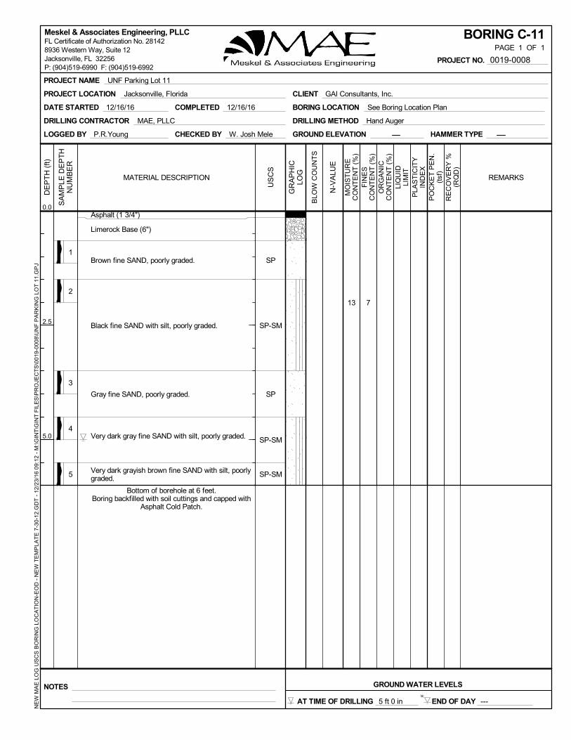
13
1
2
3
4
5
7
Asphalt (1 3/4")
Limerock Base (6")
Brown fine SAND, poorly graded.
Black fine SAND with silt, poorly graded.
Gray fine SAND, poorly graded.
Very dark gray fine SAND with silt, poorly graded.
Very dark grayish brown fine SAND with silt, poorlygraded.
SP
SP-SM
SP
SP-SM
SP-SM
COMPLETED 12/16/16DATE STARTED 12/16/16
DRILLING CONTRACTOR MAE, PLLC
LOGGED BY P.R.Young CHECKED BY W. Josh Mele GROUND ELEVATION HAMMER TYPE
DRILLING METHOD Hand Auger
BORING LOCATION See Boring Location Plan
MO
IST
UR
EC
ON
TE
NT
(%
)
PLA
ST
ICIT
YIN
DE
X
GR
AP
HIC
LOG
N-V
ALU
E
BLO
W C
OU
NT
S
REMARKS
SA
MP
LE D
EP
TH
NU
MB
ER
PO
CK
ET
PE
N.
(tsf
)R
EC
OV
ER
Y %
(RQ
D)
FIN
ES
CO
NT
EN
T (
%)
LIQ
UID
LIM
IT
MATERIAL DESCRIPTION
DE
PT
H (
ft)
0.0
2.5
5.0
OR
GA
NIC
CO
NT
EN
T (
%)
US
CS
BORING C-11PAGE 1 OF 1
NOTES GROUND WATER LEVELS
END OF DAY ---
PROJECT NAME UNF Parking Lot 11
PROJECT LOCATION Jacksonville, Florida CLIENT GAI Consultants, Inc.
PROJECT NO. 0019-0008
NE
W M
AE
LO
G U
SC
S B
OR
ING
LO
CA
TIO
N-E
OD
- N
EW
TE
MP
LAT
E 7
-30-
12.G
DT
- 1
2/23
/16
09:
12 -
M:\G
INT
\GIN
T F
ILE
S\P
RO
JEC
TS
\001
9-0
008\
UN
F P
AR
KIN
G L
OT
11.
GP
JMeskel & Associates Engineering, PLLCFL Certificate of Authorization No. 281428936 Western Way, Suite 12Jacksonville, FL 32256P: (904)519-6990 F: (904)519-6992
Bottom of borehole at 6 feet.Boring backfilled with soil cuttings and capped with
Asphalt Cold Patch.
AT TIME OF DRILLING 5 ft 0 in

1
2
3
4
Asphalt (1 3/4")
Limerock Base (6")
Brown fine SAND, poorly graded.
Black fine SAND with silt, poorly graded.
Grayish brown fine SAND with silt, poorly graded.
Very dark brown fine SAND with silt, poorly graded.
SP
SP-SM
SP-SM
SP-SM
COMPLETED 12/16/16DATE STARTED 12/16/16
DRILLING CONTRACTOR MAE, PLLC
LOGGED BY P.R.Young CHECKED BY W. Josh Mele GROUND ELEVATION HAMMER TYPE
DRILLING METHOD Hand Auger
BORING LOCATION See Boring Location Plan
MO
IST
UR
EC
ON
TE
NT
(%
)
PLA
ST
ICIT
YIN
DE
X
GR
AP
HIC
LOG
N-V
ALU
E
BLO
W C
OU
NT
S
REMARKS
SA
MP
LE D
EP
TH
NU
MB
ER
PO
CK
ET
PE
N.
(tsf
)R
EC
OV
ER
Y %
(RQ
D)
FIN
ES
CO
NT
EN
T (
%)
LIQ
UID
LIM
IT
MATERIAL DESCRIPTION
DE
PT
H (
ft)
0.0
2.5
5.0
OR
GA
NIC
CO
NT
EN
T (
%)
US
CS
BORING C-12PAGE 1 OF 1
NOTES GROUND WATER LEVELS
END OF DAY ---
PROJECT NAME UNF Parking Lot 11
PROJECT LOCATION Jacksonville, Florida CLIENT GAI Consultants, Inc.
PROJECT NO. 0019-0008
NE
W M
AE
LO
G U
SC
S B
OR
ING
LO
CA
TIO
N-E
OD
- N
EW
TE
MP
LAT
E 7
-30-
12.G
DT
- 1
2/23
/16
09:
12 -
M:\G
INT
\GIN
T F
ILE
S\P
RO
JEC
TS
\001
9-0
008\
UN
F P
AR
KIN
G L
OT
11.
GP
JMeskel & Associates Engineering, PLLCFL Certificate of Authorization No. 281428936 Western Way, Suite 12Jacksonville, FL 32256P: (904)519-6990 F: (904)519-6992
Bottom of borehole at 6 feet.Boring backfilled with soil cuttings and capped with
Asphalt Cold Patch.
AT TIME OF DRILLING 5 ft 7 in
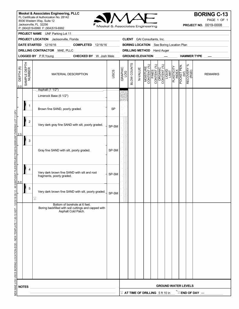
1
2
3
4
5
Asphalt (1 1/2")
Limerock Base (6 1/2")
Brown fine SAND, poorly graded.
Very dark gray fine SAND with silt, poorly graded.
Gray fine SAND with silt, poorly graded.
Very dark brown fine SAND with silt and rootfragments, poorly graded.
Very dark brown fine SAND with silt, poorly graded.
SP
SP-SM
SP-SM
SP-SM
SP-SM
COMPLETED 12/16/16DATE STARTED 12/16/16
DRILLING CONTRACTOR MAE, PLLC
LOGGED BY P.R.Young CHECKED BY W. Josh Mele GROUND ELEVATION HAMMER TYPE
DRILLING METHOD Hand Auger
BORING LOCATION See Boring Location Plan
MO
IST
UR
EC
ON
TE
NT
(%
)
PLA
ST
ICIT
YIN
DE
X
GR
AP
HIC
LOG
N-V
ALU
E
BLO
W C
OU
NT
S
REMARKS
SA
MP
LE D
EP
TH
NU
MB
ER
PO
CK
ET
PE
N.
(tsf
)R
EC
OV
ER
Y %
(RQ
D)
FIN
ES
CO
NT
EN
T (
%)
LIQ
UID
LIM
IT
MATERIAL DESCRIPTION
DE
PT
H (
ft)
0.0
2.5
5.0
OR
GA
NIC
CO
NT
EN
T (
%)
US
CS
BORING C-13PAGE 1 OF 1
NOTES GROUND WATER LEVELS
END OF DAY ---
PROJECT NAME UNF Parking Lot 11
PROJECT LOCATION Jacksonville, Florida CLIENT GAI Consultants, Inc.
PROJECT NO. 0019-0008
NE
W M
AE
LO
G U
SC
S B
OR
ING
LO
CA
TIO
N-E
OD
- N
EW
TE
MP
LAT
E 7
-30-
12.G
DT
- 1
2/23
/16
09:
12 -
M:\G
INT
\GIN
T F
ILE
S\P
RO
JEC
TS
\001
9-0
008\
UN
F P
AR
KIN
G L
OT
11.
GP
JMeskel & Associates Engineering, PLLCFL Certificate of Authorization No. 281428936 Western Way, Suite 12Jacksonville, FL 32256P: (904)519-6990 F: (904)519-6992
Bottom of borehole at 6 feet.Boring backfilled with soil cuttings and capped with
Asphalt Cold Patch.
AT TIME OF DRILLING 5 ft 10 in

1
2
3
4
Concrete (7")
Very dark brown fine SAND with silt, poorly graded.
Grayish brown fine SAND, poorly graded.
Very dark gray fine SAND with silt, poorly graded.
Very dark brown fine SAND with silt, poorly graded.
SP-SM
SP
SP-SM
SP-SM
COMPLETED 12/16/16DATE STARTED 12/16/16
DRILLING CONTRACTOR MAE, PLLC
LOGGED BY P.R.Young CHECKED BY W. Josh Mele GROUND ELEVATION HAMMER TYPE
DRILLING METHOD Hand Auger
BORING LOCATION See Boring Location Plan
MO
IST
UR
EC
ON
TE
NT
(%
)
PLA
ST
ICIT
YIN
DE
X
GR
AP
HIC
LOG
N-V
ALU
E
BLO
W C
OU
NT
S
REMARKS
SA
MP
LE D
EP
TH
NU
MB
ER
PO
CK
ET
PE
N.
(tsf
)R
EC
OV
ER
Y %
(RQ
D)
FIN
ES
CO
NT
EN
T (
%)
LIQ
UID
LIM
IT
MATERIAL DESCRIPTION
DE
PT
H (
ft)
0.0
2.5
5.0
OR
GA
NIC
CO
NT
EN
T (
%)
US
CS
BORING C-14PAGE 1 OF 1
NOTES GROUND WATER LEVELS
END OF DAY ---
PROJECT NAME UNF Parking Lot 11
PROJECT LOCATION Jacksonville, Florida CLIENT GAI Consultants, Inc.
PROJECT NO. 0019-0008
NE
W M
AE
LO
G U
SC
S B
OR
ING
LO
CA
TIO
N-E
OD
- N
EW
TE
MP
LAT
E 7
-30-
12.G
DT
- 1
2/23
/16
09:
12 -
M:\G
INT
\GIN
T F
ILE
S\P
RO
JEC
TS
\001
9-0
008\
UN
F P
AR
KIN
G L
OT
11.
GP
JMeskel & Associates Engineering, PLLCFL Certificate of Authorization No. 281428936 Western Way, Suite 12Jacksonville, FL 32256P: (904)519-6990 F: (904)519-6992
Bottom of borehole at 6 feet.Boring backfilled with soil cuttings and capped with
Concrete Mix.
AT TIME OF DRILLING 4 ft 11 in

1
2
3
4
Asphalt (1 7/8")
Limerock Base (6")
Very dark grayish brown fine SAND with silt, poorlygraded.
Very dark gray and black fine SAND with silt, poorlygraded.
Yellowish brown fine SAND with silt, poorly graded.
Light brownish gray fine SAND with silt, poorlygraded.
SP-SM
SP-SM
SP-SM
SP-SM
COMPLETED 12/16/16DATE STARTED 12/16/16
DRILLING CONTRACTOR MAE, PLLC
LOGGED BY P.R.Young CHECKED BY W. Josh Mele GROUND ELEVATION HAMMER TYPE
DRILLING METHOD Hand Auger
BORING LOCATION See Boring Location Plan
MO
IST
UR
EC
ON
TE
NT
(%
)
PLA
ST
ICIT
YIN
DE
X
GR
AP
HIC
LOG
N-V
ALU
E
BLO
W C
OU
NT
S
REMARKS
SA
MP
LE D
EP
TH
NU
MB
ER
PO
CK
ET
PE
N.
(tsf
)R
EC
OV
ER
Y %
(RQ
D)
FIN
ES
CO
NT
EN
T (
%)
LIQ
UID
LIM
IT
MATERIAL DESCRIPTION
DE
PT
H (
ft)
0.0
2.5
5.0
OR
GA
NIC
CO
NT
EN
T (
%)
US
CS
BORING C-15PAGE 1 OF 1
NOTES GROUND WATER LEVELS
END OF DAY ---
PROJECT NAME UNF Parking Lot 11
PROJECT LOCATION Jacksonville, Florida CLIENT GAI Consultants, Inc.
PROJECT NO. 0019-0008
NE
W M
AE
LO
G U
SC
S B
OR
ING
LO
CA
TIO
N-E
OD
- N
EW
TE
MP
LAT
E 7
-30-
12.G
DT
- 1
2/23
/16
09:
12 -
M:\G
INT
\GIN
T F
ILE
S\P
RO
JEC
TS
\001
9-0
008\
UN
F P
AR
KIN
G L
OT
11.
GP
JMeskel & Associates Engineering, PLLCFL Certificate of Authorization No. 281428936 Western Way, Suite 12Jacksonville, FL 32256P: (904)519-6990 F: (904)519-6992
Bottom of borehole at 6 feet.Boring backfilled with soil cuttings and capped with
Asphalt Cold Patch.
AT TIME OF DRILLING 4 ft 4 in

COMPLETED 12/16/16DATE STARTED 12/16/16
DRILLING CONTRACTOR MAE, PLLC
LOGGED BY P.R.Young CHECKED BY W. Josh Mele GROUND ELEVATION HAMMER TYPE
DRILLING METHOD Hand Auger
BORING LOCATION See Boring Location Plan
MO
IST
UR
EC
ON
TE
NT
(%
)
PLA
ST
ICIT
YIN
DE
X
GR
AP
HIC
LOG
N-V
ALU
E
BLO
W C
OU
NT
S
REMARKS
SA
MP
LE D
EP
TH
NU
MB
ER
PO
CK
ET
PE
N.
(tsf
)R
EC
OV
ER
Y %
(RQ
D)
FIN
ES
CO
NT
EN
T (
%)
LIQ
UID
LIM
IT
MATERIAL DESCRIPTION
29
1
2
3
4
Asphalt (1 3/4")
Limerock Base (7 1/4")
Black fine SAND, trace organic fines, poorlygraded.
Light yellowish brown fine SAND, poorly graded.
Pale brown fine SAND, poorly graded.
Light gray fine SAND, poorly graded.
0.3SP
SP
SP
SP
DE
PT
H (
ft)
0.0
2.5
5.0
OR
GA
NIC
CO
NT
EN
T (
%)
US
CS
BORING C-16PAGE 1 OF 1
NOTES GROUND WATER LEVELS
END OF DAY ---
PROJECT NAME UNF Parking Lot 11
PROJECT LOCATION Jacksonville, Florida CLIENT GAI Consultants, Inc.
PROJECT NO. 0019-0008
NE
W M
AE
LO
G U
SC
S B
OR
ING
LO
CA
TIO
N-E
OD
- N
EW
TE
MP
LAT
E 7
-30-
12.G
DT
- 1
2/23
/16
09:
12 -
M:\G
INT
\GIN
T F
ILE
S\P
RO
JEC
TS
\001
9-0
008\
UN
F P
AR
KIN
G L
OT
11.
GP
JMeskel & Associates Engineering, PLLCFL Certificate of Authorization No. 281428936 Western Way, Suite 12Jacksonville, FL 32256P: (904)519-6990 F: (904)519-6992
Bottom of borehole at 6 feet.Boring backfilled with soil cuttings and capped with
Asphalt Cold Patch.
AT TIME OF DRILLING 4 ft 4 in

1
2
3
4
Asphalt (1 5/8")
Limerock Base (6 3/8")
Grayish brown fine SAND with silt and gravel (rockfragments), poorly graded.
Light yellowish brown fine SAND with silt, poorlygraded.
Very pale brown fine SAND with silt, poorly graded.
White fine SAND, poorly graded.
SP-SM
SP-SM
SP-SM
SP
COMPLETED 12/16/16DATE STARTED 12/16/16
DRILLING CONTRACTOR MAE, PLLC
LOGGED BY P.R.Young CHECKED BY W. Josh Mele GROUND ELEVATION HAMMER TYPE
DRILLING METHOD Hand Auger
BORING LOCATION See Boring Location Plan
MO
IST
UR
EC
ON
TE
NT
(%
)
PLA
ST
ICIT
YIN
DE
X
GR
AP
HIC
LOG
N-V
ALU
E
BLO
W C
OU
NT
S
REMARKS
SA
MP
LE D
EP
TH
NU
MB
ER
PO
CK
ET
PE
N.
(tsf
)R
EC
OV
ER
Y %
(RQ
D)
FIN
ES
CO
NT
EN
T (
%)
LIQ
UID
LIM
IT
MATERIAL DESCRIPTION
DE
PT
H (
ft)
0.0
2.5
5.0
OR
GA
NIC
CO
NT
EN
T (
%)
US
CS
BORING C-17PAGE 1 OF 1
NOTES GROUND WATER LEVELS
END OF DAY ---
PROJECT NAME UNF Parking Lot 11
PROJECT LOCATION Jacksonville, Florida CLIENT GAI Consultants, Inc.
PROJECT NO. 0019-0008
NE
W M
AE
LO
G U
SC
S B
OR
ING
LO
CA
TIO
N-E
OD
- N
EW
TE
MP
LAT
E 7
-30-
12.G
DT
- 1
2/23
/16
09:
12 -
M:\G
INT
\GIN
T F
ILE
S\P
RO
JEC
TS
\001
9-0
008\
UN
F P
AR
KIN
G L
OT
11.
GP
JMeskel & Associates Engineering, PLLCFL Certificate of Authorization No. 281428936 Western Way, Suite 12Jacksonville, FL 32256P: (904)519-6990 F: (904)519-6992
Bottom of borehole at 6 feet.Boring backfilled with soil cuttings and capped with
Asphalt Cold Patch.
AT TIME OF DRILLING 3 ft 10 in

1
2
3
4
Asphalt (1 3/4")
Limerock Base (6 1/4")
Pale brown fine SAND, poorly graded.
Very pale brown fine SAND, poorly graded.
Light gray fine SAND, poorly graded.
SP
SP
SP
COMPLETED 12/16/16DATE STARTED 12/16/16
DRILLING CONTRACTOR MAE, PLLC
LOGGED BY P.R.Young CHECKED BY W. Josh Mele GROUND ELEVATION HAMMER TYPE
DRILLING METHOD Hand Auger
BORING LOCATION See Boring Location Plan
MO
IST
UR
EC
ON
TE
NT
(%
)
PLA
ST
ICIT
YIN
DE
X
GR
AP
HIC
LOG
N-V
ALU
E
BLO
W C
OU
NT
S
REMARKS
SA
MP
LE D
EP
TH
NU
MB
ER
PO
CK
ET
PE
N.
(tsf
)R
EC
OV
ER
Y %
(RQ
D)
FIN
ES
CO
NT
EN
T (
%)
LIQ
UID
LIM
IT
MATERIAL DESCRIPTION
DE
PT
H (
ft)
0.0
2.5
5.0
OR
GA
NIC
CO
NT
EN
T (
%)
US
CS
BORING C-18PAGE 1 OF 1
NOTES GROUND WATER LEVELS
END OF DAY ---
PROJECT NAME UNF Parking Lot 11
PROJECT LOCATION Jacksonville, Florida CLIENT GAI Consultants, Inc.
PROJECT NO. 0019-0008
NE
W M
AE
LO
G U
SC
S B
OR
ING
LO
CA
TIO
N-E
OD
- N
EW
TE
MP
LAT
E 7
-30-
12.G
DT
- 1
2/23
/16
09:
12 -
M:\G
INT
\GIN
T F
ILE
S\P
RO
JEC
TS
\001
9-0
008\
UN
F P
AR
KIN
G L
OT
11.
GP
JMeskel & Associates Engineering, PLLCFL Certificate of Authorization No. 281428936 Western Way, Suite 12Jacksonville, FL 32256P: (904)519-6990 F: (904)519-6992
Bottom of borehole at 6 feet.Boring backfilled with soil cuttings and capped with
Asphalt Cold Patch.
AT TIME OF DRILLING 4 ft 0 in
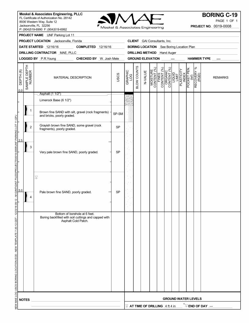
1
2
3
4
Asphalt (1 1/2")
Limerock Base (6 1/2")
Brown fine SAND with silt, gravel (rock fragments)and bricks, poorly graded.
Grayish brown fine SAND, some gravel (rockfragments), poorly graded.
Very pale brown fine SAND, poorly graded.
Pale brown fine SAND, poorly graded.
SP-SM
SP
SP
SP
COMPLETED 12/16/16DATE STARTED 12/16/16
DRILLING CONTRACTOR MAE, PLLC
LOGGED BY P.R.Young CHECKED BY W. Josh Mele GROUND ELEVATION HAMMER TYPE
DRILLING METHOD Hand Auger
BORING LOCATION See Boring Location Plan
MO
IST
UR
EC
ON
TE
NT
(%
)
PLA
ST
ICIT
YIN
DE
X
GR
AP
HIC
LOG
N-V
ALU
E
BLO
W C
OU
NT
S
REMARKS
SA
MP
LE D
EP
TH
NU
MB
ER
PO
CK
ET
PE
N.
(tsf
)R
EC
OV
ER
Y %
(RQ
D)
FIN
ES
CO
NT
EN
T (
%)
LIQ
UID
LIM
IT
MATERIAL DESCRIPTION
DE
PT
H (
ft)
0.0
2.5
5.0
OR
GA
NIC
CO
NT
EN
T (
%)
US
CS
BORING C-19PAGE 1 OF 1
NOTES GROUND WATER LEVELS
END OF DAY ---
PROJECT NAME UNF Parking Lot 11
PROJECT LOCATION Jacksonville, Florida CLIENT GAI Consultants, Inc.
PROJECT NO. 0019-0008
NE
W M
AE
LO
G U
SC
S B
OR
ING
LO
CA
TIO
N-E
OD
- N
EW
TE
MP
LAT
E 7
-30-
12.G
DT
- 1
2/23
/16
09:
12 -
M:\G
INT
\GIN
T F
ILE
S\P
RO
JEC
TS
\001
9-0
008\
UN
F P
AR
KIN
G L
OT
11.
GP
JMeskel & Associates Engineering, PLLCFL Certificate of Authorization No. 281428936 Western Way, Suite 12Jacksonville, FL 32256P: (904)519-6990 F: (904)519-6992
Bottom of borehole at 6 feet.Boring backfilled with soil cuttings and capped with
Asphalt Cold Patch.
AT TIME OF DRILLING 4 ft 4 in

1
2
3
4
5
Asphalt (1 1/2")
Limerock Base (6")
Very dark grayish brown fine SAND with silt, poorlygraded.
Grayish brown fine SAND, few gravel (rockfragments), poorly graded.
Gray fine SAND with silt, trace gravel (rockfragments), poorly graded.
Dark brown fine SAND with silt, poorly graded.
Grayish brown fine SAND with silt, poorly graded.
SP-SM
SP
SP-SM
SP-SM
SP-SM
COMPLETED 12/16/16DATE STARTED 12/16/16
DRILLING CONTRACTOR MAE, PLLC
LOGGED BY P.R.Young CHECKED BY W. Josh Mele GROUND ELEVATION HAMMER TYPE
DRILLING METHOD Hand Auger
BORING LOCATION See Boring Location Plan
MO
IST
UR
EC
ON
TE
NT
(%
)
PLA
ST
ICIT
YIN
DE
X
GR
AP
HIC
LOG
N-V
ALU
E
BLO
W C
OU
NT
S
REMARKS
SA
MP
LE D
EP
TH
NU
MB
ER
PO
CK
ET
PE
N.
(tsf
)R
EC
OV
ER
Y %
(RQ
D)
FIN
ES
CO
NT
EN
T (
%)
LIQ
UID
LIM
IT
MATERIAL DESCRIPTION
DE
PT
H (
ft)
0.0
2.5
5.0
OR
GA
NIC
CO
NT
EN
T (
%)
US
CS
BORING C-20PAGE 1 OF 1
NOTES GROUND WATER LEVELS
END OF DAY ---
PROJECT NAME UNF Parking Lot 11
PROJECT LOCATION Jacksonville, Florida CLIENT GAI Consultants, Inc.
PROJECT NO. 0019-0008
NE
W M
AE
LO
G U
SC
S B
OR
ING
LO
CA
TIO
N-E
OD
- N
EW
TE
MP
LAT
E 7
-30-
12.G
DT
- 1
2/23
/16
09:
12 -
M:\G
INT
\GIN
T F
ILE
S\P
RO
JEC
TS
\001
9-0
008\
UN
F P
AR
KIN
G L
OT
11.
GP
JMeskel & Associates Engineering, PLLCFL Certificate of Authorization No. 281428936 Western Way, Suite 12Jacksonville, FL 32256P: (904)519-6990 F: (904)519-6992
Bottom of borehole at 6 feet.Boring backfilled with soil cuttings and capped with
Asphalt Cold Patch.
AT TIME OF DRILLING 5 ft 4 in

1
2
3
4
Asphalt (2 1/2")
Limerock Base (6 1/2")
Very dark brown fine SAND, poorly graded.
Grayish brown fine SAND with silt, trace gravel(rock fragments), poorly graded.
Light gray fine SAND, poorly graded.
SP
SP-SM
SP
COMPLETED 12/16/16DATE STARTED 12/16/16
DRILLING CONTRACTOR MAE, PLLC
LOGGED BY P.R.Young CHECKED BY W. Josh Mele GROUND ELEVATION HAMMER TYPE
DRILLING METHOD Hand Auger
BORING LOCATION See Boring Location Plan
MO
IST
UR
EC
ON
TE
NT
(%
)
PLA
ST
ICIT
YIN
DE
X
GR
AP
HIC
LOG
N-V
ALU
E
BLO
W C
OU
NT
S
REMARKS
SA
MP
LE D
EP
TH
NU
MB
ER
PO
CK
ET
PE
N.
(tsf
)R
EC
OV
ER
Y %
(RQ
D)
FIN
ES
CO
NT
EN
T (
%)
LIQ
UID
LIM
IT
MATERIAL DESCRIPTION
DE
PT
H (
ft)
0.0
2.5
5.0
OR
GA
NIC
CO
NT
EN
T (
%)
US
CS
BORING C-21PAGE 1 OF 1
NOTES GROUND WATER LEVELS
END OF DAY ---
PROJECT NAME UNF Parking Lot 11
PROJECT LOCATION Jacksonville, Florida CLIENT GAI Consultants, Inc.
PROJECT NO. 0019-0008
NE
W M
AE
LO
G U
SC
S B
OR
ING
LO
CA
TIO
N-E
OD
- N
EW
TE
MP
LAT
E 7
-30-
12.G
DT
- 1
2/23
/16
09:
12 -
M:\G
INT
\GIN
T F
ILE
S\P
RO
JEC
TS
\001
9-0
008\
UN
F P
AR
KIN
G L
OT
11.
GP
JMeskel & Associates Engineering, PLLCFL Certificate of Authorization No. 281428936 Western Way, Suite 12Jacksonville, FL 32256P: (904)519-6990 F: (904)519-6992
Bottom of borehole at 6 feet.Boring backfilled with soil cuttings and capped with
Asphalt Cold Patch.
AT TIME OF DRILLING 3 ft 5 in

39
1
2
3
4
Asphalt (1 1/2")
Limerock Base (7 1/2")
Dark brown fine SAND, poorly graded.
Grayish brown fine SAND with silt, poorly graded.
Black fine SAND with silt, trace organic fines,poorly graded.
Very dark brown fine SAND with silt, few organicfines, poorly graded
3.8
SP
SP-SM
SP-SM
SP-SM
COMPLETED 12/16/16DATE STARTED 12/16/16
DRILLING CONTRACTOR MAE, PLLC
LOGGED BY P.R.Young CHECKED BY W. Josh Mele GROUND ELEVATION HAMMER TYPE
DRILLING METHOD Hand Auger
BORING LOCATION See Boring Location Plan
MO
IST
UR
EC
ON
TE
NT
(%
)
PLA
ST
ICIT
YIN
DE
X
GR
AP
HIC
LOG
N-V
ALU
E
BLO
W C
OU
NT
S
REMARKS
SA
MP
LE D
EP
TH
NU
MB
ER
PO
CK
ET
PE
N.
(tsf
)R
EC
OV
ER
Y %
(RQ
D)
FIN
ES
CO
NT
EN
T (
%)
LIQ
UID
LIM
IT
MATERIAL DESCRIPTION
DE
PT
H (
ft)
0.0
2.5
5.0
OR
GA
NIC
CO
NT
EN
T (
%)
US
CS
BORING C-22PAGE 1 OF 1
NOTES GROUND WATER LEVELS
END OF DAY ---
PROJECT NAME UNF Parking Lot 11
PROJECT LOCATION Jacksonville, Florida CLIENT GAI Consultants, Inc.
PROJECT NO. 0019-0008
NE
W M
AE
LO
G U
SC
S B
OR
ING
LO
CA
TIO
N-E
OD
- N
EW
TE
MP
LAT
E 7
-30-
12.G
DT
- 1
2/23
/16
09:
12 -
M:\G
INT
\GIN
T F
ILE
S\P
RO
JEC
TS
\001
9-0
008\
UN
F P
AR
KIN
G L
OT
11.
GP
JMeskel & Associates Engineering, PLLCFL Certificate of Authorization No. 281428936 Western Way, Suite 12Jacksonville, FL 32256P: (904)519-6990 F: (904)519-6992
Bottom of borehole at 6 feet.Boring backfilled with soil cuttings and capped with
Asphalt Cold Patch.
AT TIME OF DRILLING 5 ft 0 in

FIELDEXPLORATIONPROCEDURES
StandardPenetrationTest(SPT)BoringsUsingPortable(Tripod)Equipment
TheStandardPenetrationTest(SPT)boring(s)wereperformedusingportableequipment.Thisgenerallyinvolvessettingupatripodmetalframewithacatheadandmotorattachedtotheframetoraiseandlowerthedrillrod.Thisequipmentisusedwhenaconventionalmotorized drill rig cannot access the boring location(s). Due to the limitations of thisequipment,rotarywashdrillingtechniques,normallyusedtoadvancetheborehole,arenotpossible.Therefore,theboringswereadvancedbetweensamplingintervalsusinga“washandchop”drillingmethod.Thismethodinvolvesrepeatedlyraisingandloweringthedrillrodtobreakup,or“chop”,thesoillayersandusingbentoniteslurryto“wash”thecuttingstothesurface,thusadvancingtheborehole.
SamplesfromtheboringswereobtainedingeneralaccordancewiththelatestrevisionofASTMD1586,“PenetrationTestandSplit‐BarrelSamplingofSoils”.Asplit‐barrelsamplerwasinsertedtotheboreholebottomanddriven18to24inchesintothesoilusinga140‐pound hammer dropped an average of 30 inches per hammer blow. The number ofhammerblows for the final 12 inches of penetration (18” sample) or for the sumof themiddle12inchesofpenetration(24”sample) istermedthe“penetrationresistance,blowcount,orN‐value.” Thisvalueisanindextoseveralin‐situgeotechnicalpropertiesofthematerialtested,suchasrelativedensityandYoung’sModulus.
Afterdrivingthesampler,itwasretrievedfromtheboreholeandrepresentativesamplesofthematerialwithin the split‐barrelwere containerizedand sealed. After completing thedrillingoperations,thesamplesforeachboringweretransportedtothelaboratorywheretheywereexaminedbyourengineerinordertoverifythefielddescriptions.

K E Y T O B O R I N G L O G S – U S C S
S o i l C l a s s i f i c a t i o n Soil classification of samples obtained at the boring locations is based on the Unified Soil Classification System (USCS). Coarse grained soils have more than 50% of their dry weight retained on a #200 sieve. Their principal descriptors are: sand, cobbles and boulders. Fine grained soils have less than 50% of their dry weight retained on a #200 sieve. They are principally described as clays if they are plastic and silts if they are slightly to non-plastic. Major constituents may be added as modifiers and minor constituents may be added according to the relative proportions based on grain size. In addition to gradation, coarse-grained soils are defined on the basis of their in-place relative density and fine-grained soils on the basis of their consistency.
KBLS- USCCS-Safety
BORING LOG LEGEND Symbol Description
N Standard Penetration Resistance, the number of blows required to advance a standard spoon sampler 12" when driven by a 140-lb hammer dropping 30".
WOR Split Spoon sampler advanced under the weight of the drill rods WOH Split Spoon sampler advanced under the weight of the SPT hammer 50/2” Indicates 50 hammer blows drove the split spoon 2 inches; 50 Hammer blows for less than 6-
inches of split spoon driving is considered “Refusal”.
(SP) Unified Soil Classification System -200 Fines content, % Passing No. 200 U.S. Standard Sieve
w Natural Moisture Content (%) OC Organic Content (%) LL Liquid Limit PI Plasticity Index NP PP
Non-Plastic Pocket Penetrometer in tons per square foot (tsf)
MODIFIERS RELATIVE DENSITY (Coarse-Grained Soils)
Relative Density N-Value SECONDARY CONSTITUENTS Very Loose Less than 4
(Sand, Silt or Clay) Loose 4 to 10 Trace Less than 5% Medium Dense 10 to 30 With 5% to 12% Dense 30 to 50
Sandy, Silty or Clayey 12% to 35% Very Dense Greater than 50 Very Sandy, Very Silty or Very Clayey 35% to 50%
CONSISTENCY (Fine-Grained Soils) ORGANIC CONTENT Consistency N-Value
Trace 2% or less Very Soft Less than 2 Few 3% to 5% Soft 2 to 4
Little 5% to 10% Firm 4 to 8 With Greater than 10% Stiff 8 to 15
Very Stiff 15 to 30 Hard Greater than 30
MINOR COMPONENTS (Shell, Rock, Debris, Roots, etc.) RELATIVE HARDNESS (Limestone)
Trace Less than 5% Relative Hardness N-Value Few 5% to 10% Soft Less than 50
Little 15% to 25% Hard Greater than 50
Some 30% to 45%

Prefix: G = Gravel, S = Sand, M = Silt, C = Clay, O = Organic Suffix: W = Well Graded, P = Poorly Graded, M = Silty, L = Clay, LL < 50%, H = Clay, LL > 50%
Unified Soil Classification System (USCS) (from ASTM D 2487)
Major Divisions Group
Symbol Typical Names
Coarse-Grained Soils More than 50% retained on the 0.075 mm (No. 200) sieve
Gravels 50% or more of coarse fraction retained on the 4.75 mm (No. 4) sieve
Clean Gravels
GW Well-graded gravels and gravel-sand mixtures, little or no fines
GP Poorly graded gravels and gravel-sand mixtures, little or no fines
Gravels with Fines
GM Silty gravels, gravel-sand-silt mixtures
GC Clayey gravels, gravel-sand-clay mixtures
Sands 50% or more of coarse fraction passes the 4.75 (No. 4) sieve
Clean Sands
SW Well-graded sands and gravelly sands, little or no fines
SP Poorly graded sands and gravelly sands, little or no fines
Sands with Fines
SM Silty sands, sand-silt mixtures
SC Clayey sands, sand-clay mixtures
Fine-Grained Soils More than 50% passes the 0.075 mm (No. 200) sieve
Silts and Clays Liquid Limit 50% or less
ML Inorganic silts, very fine sands, rock four, silty or clayey fine sands
CL Inorganic clays of low to medium plasticity, gravelly/sandy/silty/lean clays
OL Organic silts and organic silty clays of low plasticity
Silts and Clays Liquid Limit greater than 50%
MH Inorganic silts, micaceous or diatomaceous fine sands or silts, elastic silts
CH Inorganic clays or high plasticity, fat clays
OH Organic clays of medium to high plasticity
Highly Organic Soils PT Peat, muck, and other highly organic soils

Appendix B _____________________________________________________________________________________

B-1 3 5 3 26 SP--- --- --- ---
Sample NoBorehole %<#200Sieve
WaterContent
(%)
OrganicContent
(%)
LiquidLimit
PlasticLimit CommentsPlasticity
Index ClassificationUSCS
DATE.
SUMMARY OF LABORATORYTEST RESULTS
Approx.Depth
PROJECT NAME UNF Parking Lot 11
PROJECT LOCATION Jacksonville, Florida CLIENT GAI Consultants, Inc.
PROJECT NO. 0019-0008
LAB
SU
MM
AR
Y_M
AE
_ALL
PR
OJE
CT
S -
GIN
T S
TD
US
LA
B.G
DT
- 1
2/23
/16
09:
47 -
M:\G
INT
\GIN
T F
ILE
S\P
RO
JEC
TS
\001
9-0
008\
LA
B_U
NF
PA
RK
ING
LO
T 1
1.G
PJ
Meskel & Associates Engineering, PLLCFL Certificate of Authorization No. 281428936 Western Way, Suite 12Jacksonville, FL 32256P: (904)519-6990 F: (904)519-6992
12/28/2016
Note: "---" Untested Parameter
B-2 2 3 2 22 SP
C-11 2 2 7 13 SP-SM
C-8 2 2 9 15 SP-SM--- --- --- ---
--- ---
C-16 1 2 29 0.3 SP
C-22 3 3 39 3.8 SP-SM
--- ---
--- --- --- ---
--- --- ---
--- --- ---
---
---
B-1 --- --- --- SP-SM4 7 --- 30 5.5

LABORATORY TEST PROCEDURES
Percent Fines Content
The percent fines or material passing the No. 200 mesh sieve of the sample tested was
determined in general accordance with the latest revision of ASTM D 1140. The percent
fines are the soil particles in the silt and clay size range.
Natural Moisture Content
The water content of the tested sample was determined in general accordance with the
latest revision of ASTM D 2216. The water content is defined as the ratio of “pore” or “free”
water in a given mass of material to the mass of solid material particles.
Organic Loss on Ignition (Percent Organics)
The organic loss on ignition or percent organic material in the sample tested was
determined in general accordance with ASTM D 2974. The percent organics is the material,
expressed as a percentage, which is burned off in a muffle furnace at 455±10 degrees
Celsius.

Appendix C _____________________________________________________________________________________
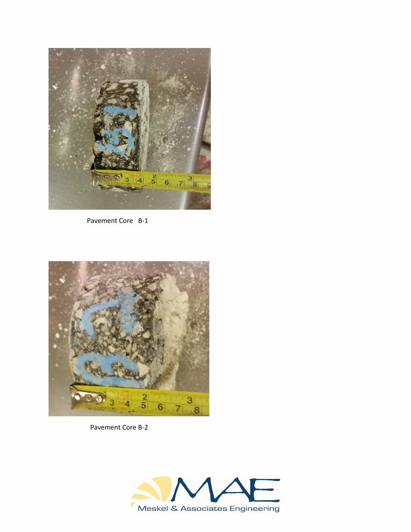
Pavement Core B-1
Pavement Core B-2
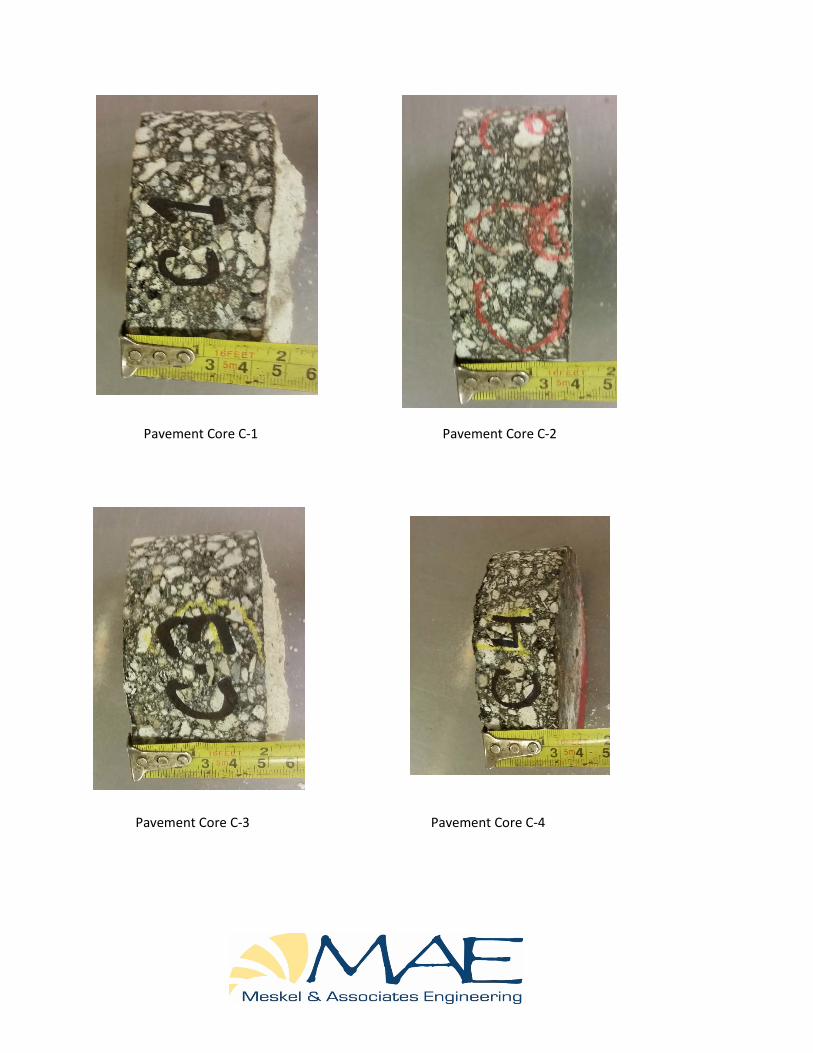
Pavement Core C-1 Pavement Core C-2
Pavement Core C-3 Pavement Core C-4

Pavement Core C-5 Pavement Core C-6
Pavement Core C-7 Pavement Core C-8

Pavement Core C-9 Pavement Core C-10
Pavement Core C-11 Pavement Core C-12
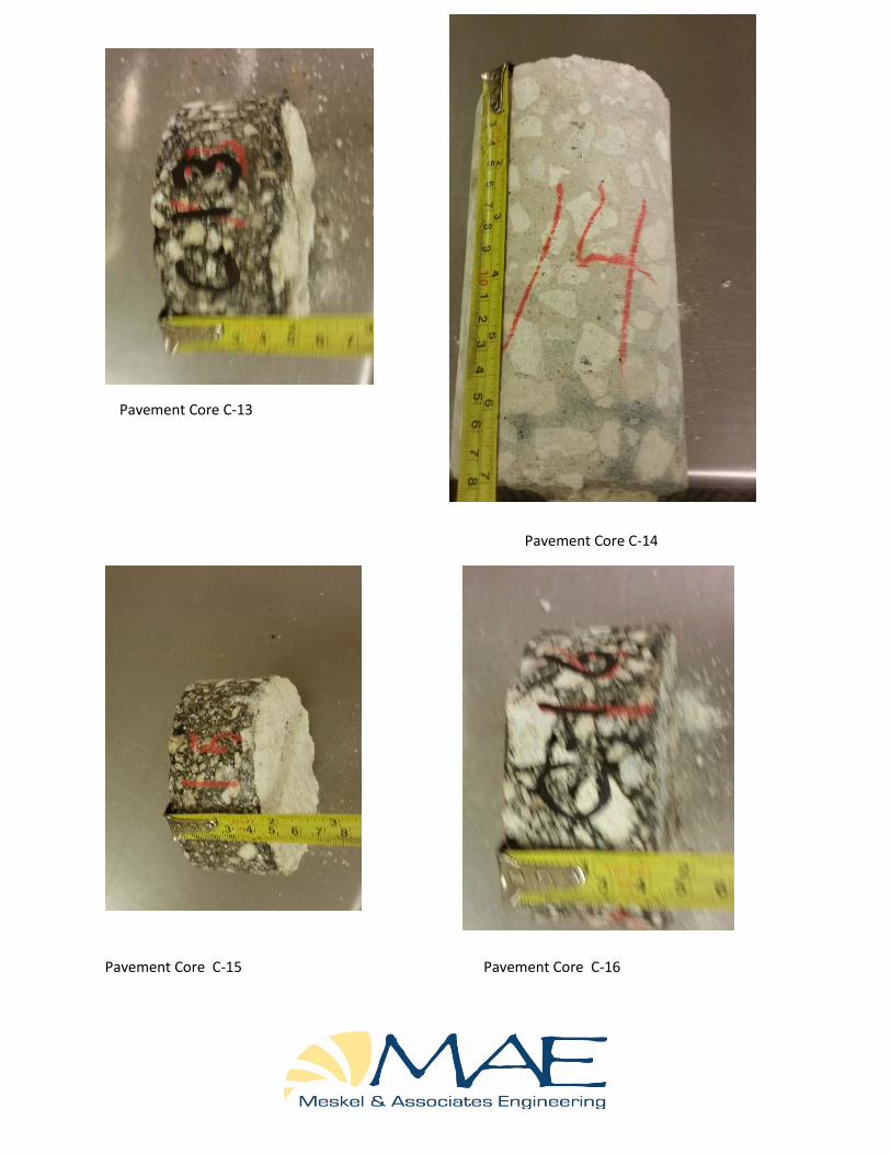
Pavement Core C-13
Pavement Core C-14
Pavement Core C-15 Pavement Core C-16
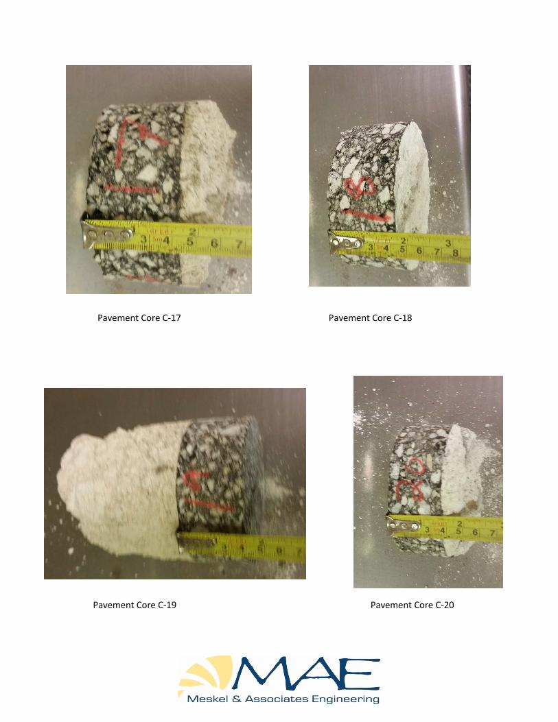
Pavement Core C-17 Pavement Core C-18
Pavement Core C-19 Pavement Core C-20

Pavement Core C-21
Pavement Core C-22