Report of Activities, 1997 Resident Geologist Program
110
Ontario Geological Survey Open File Report 5972 Report of Activities, 1997 Resident Geologist Program Timmins Regional Resident Geologist’s Report: Timmins–Sault Ste. Marie Districts 1998
Transcript of Report of Activities, 1997 Resident Geologist Program

Ontario Geological SurveyOpen File Report 5972
Report of Activities, 1997Resident Geologist Program
Timmins Regional Resident
Geologist’s Report:
Timmins–Sault Ste. Marie Districts
1998


ONTARIO GEOLOGICAL SURVEY
Open File Report 5972
Report of Activities, 1997Resident Geologist Program
Timmins Regional Resident Geologist’s Report:Timmins–Sault Ste. Marie Districts
by
B.T. Atkinson, M.H. Hailstone, A.C. Wilson, D.M. Draper, P. Hope, P.M. Morra andD.C. Egerland
1998
Parts of this publication may be quoted if credit is given. It is recommended thatreference to this publication be made in the following form:
Atkinson, B.T., Hailstone, M.H., Wilson, A.C., Draper, D.M., Hope, P., Morra, P.M. andEgerland, D.C. 1998. Report of Activities 1997, Resident Geologist Program,Timmins Regional Resident Geologist’s Report:Timmins–Sault Ste. Marie Districts;Ontario Geological Survey, Open File Report 5972, 89p.
e Queen’s Printer for Ontario, 1998

iii
e Queen’s Printer for Ontario, 1998.
Open File Reports of the Ontario Geological Survey are available for viewing at the Mines Library in Sudbury, at theMines andMinerals InformationCentre in Toronto, and at the regionalMines andMinerals officewhose district includesthe area covered by the report (see below).
Copies can be purchased at Publication Sales and the office whose district includes the area covered by the report. Al-though a particular report may not be in stock at locations other than the Publication Sales office in Sudbury, they cangenerally be obtained within 3 working days. All telephone, fax, mail and e--mail orders should be directed to the Publi-cation Sales office in Sudbury. Use ofVISAorMasterCard ensures the fastest possible service. Cheques ormoney ordersshould be made payable to the Minister of Finance.
Mines and Minerals Information Centre (MMIC) Tel: (416) 314-3800(local)Macdonald Block, Room M2-17 1--800--665--4480(toll free inside Ontario)900 Bay St.Toronto, Ontario M7A 1C3
Mines Library Tel: (705) 670-5614933 Ramsey Lake Road, Level A3Sudbury, Ontario P3E 6B5
Publication Sales Tel: (705) 670-5691(local)933 Ramsey Lake Rd., Level A3 1-888-415-9847(toll-free)Sudbury, Ontario P3E 6B5 Fax: (705) 670-5770
E-mail: [email protected]
Regional Mines and Minerals Offices:
Kenora - Box 5050, 810 Robertson St., Kenora P9N 3X9
Kirkland Lake - 4 Government Rd. E., Kirkland Lake P2N 1A2
Red Lake - Box 324, Ontario Government Building, Red Lake P0V 2M0
Sault Ste. Marie - 60 Church St., Sault Ste. Marie P6A 3H3
Sioux Lookout - Box 3000, Queen and Fourth, Sioux Lookout P8T 1C6
Southern Ontario - P.O. Bag Service 43, Old Troy Rd., Tweed K0K 3J0
Sudbury - Level B3, 933 Ramsey Lake Rd., Sudbury P3E 6B5
Thunder Bay - Suite B002, 435 James St. S., Thunder Bay P7E 6S7
Timmins - Ontario Government Complex, P.O. Bag 3060, Hwy. 101 East, South Porcupine P0N 1H0
Toronto - MMIC, Macdonald Block, Room M2--17, 900 Bay St., Toronto M7A 1C3
This report has not received a technical edit. Discrepanciesmay occur for which the OntarioMinistry ofNorthernDevel-opment andMines does not assume any liability. Source references are included in the report andusers are urged to verifycritical information. Recommendations and statements of opinions expressed are those of the author or authors and arenot to be construed as statements of government policy.
If you wish to reproduce any of the text, tables or illustrations in this report, please write for permission to the TeamLeader, Publication Services, Ministry of Northern Development and Mines, 933 Ramsey Lake Road, Level B4,Sudbury, Ontario P3E 6B5.
Cette publication est disponible en anglais seulement.
Parts of this report may be quoted if credit is given. It is recommended that reference be made in the following form:
Atkinson, B.T., Hailstone, M.H., Wilson, A.C., Draper, D.M., Hope, P., Morra, P.M. and Egerland, D.C. 1998.Report of Activities 1997, Resident Geologist Program, Timmins Regional Resident Geologist’sReport: Timmins–Sault Ste. Marie Districts; Ontario Geological Survey, Open File Report 5972, 89p.


v
ONTARIO GEOLOGICAL SURVEY
RESIDENT GEOLOGIST PROGRAM – 1997
TIMMINS REGIONAL RESIDENT GEOLOGIST’S DISTRICT
Contents
Timmins Resident Geologist’s District–Timmins AreaIntroduction 1. . . . . . . . . . . . . . . . . . . . . . . . . . . . . . . . . . . . . . . . . . . . . . . . . . . . . . . . . . . . . . . . . . . . . . . . . . . . . . .
Mining Activity 3. . . . . . . . . . . . . . . . . . . . . . . . . . . . . . . . . . . . . . . . . . . . . . . . . . . . . . . . . . . . . . . . . . . . . . . . . . . .
Gold Mining 4. . . . . . . . . . . . . . . . . . . . . . . . . . . . . . . . . . . . . . . . . . . . . . . . . . . . . . . . . . . . . . . . . . . . . . . . . . . . . . .Kinross Gold Corporation – Hoyle Pond Mine 4. . . . . . . . . . . . . . . . . . . . . . . . . . . . . . . . . . . . . . . . . . . . . . . .Placer Dome North America Limited – Detour Lake Mine 4. . . . . . . . . . . . . . . . . . . . . . . . . . . . . . . . . . . . . .Placer Dome North America – Dome Mine 4. . . . . . . . . . . . . . . . . . . . . . . . . . . . . . . . . . . . . . . . . . . . . . . . . . .Royal Oak Mines Inc., Timmins Division – Pamour Mine 5. . . . . . . . . . . . . . . . . . . . . . . . . . . . . . . . . . . . . . .Royal Oak Mines Inc., Timmins Division – Nighthawk Lake Mine 5. . . . . . . . . . . . . . . . . . . . . . . . . . . . . . . .
Base Metals 6. . . . . . . . . . . . . . . . . . . . . . . . . . . . . . . . . . . . . . . . . . . . . . . . . . . . . . . . . . . . . . . . . . . . . . . . . . . . . . .Falconbridge Limited – Kidd Creek Mine and Metallurgical Complex 6. . . . . . . . . . . . . . . . . . . . . . . . . . . . .
Industrial Minerals 7. . . . . . . . . . . . . . . . . . . . . . . . . . . . . . . . . . . . . . . . . . . . . . . . . . . . . . . . . . . . . . . . . . . . . . . . . .Luzenac Inc. – Penhorwood Mine 7. . . . . . . . . . . . . . . . . . . . . . . . . . . . . . . . . . . . . . . . . . . . . . . . . . . . . . . . . .
Advanced Exploration 8. . . . . . . . . . . . . . . . . . . . . . . . . . . . . . . . . . . . . . . . . . . . . . . . . . . . . . . . . . . . . . . . . . . . . . .Agrium Inc. – Cargill Project 8. . . . . . . . . . . . . . . . . . . . . . . . . . . . . . . . . . . . . . . . . . . . . . . . . . . . . . . . . . . . . .Band--Ore Resources Ltd. – Thorne Property 8. . . . . . . . . . . . . . . . . . . . . . . . . . . . . . . . . . . . . . . . . . . . . . . . .Echo Bay Mines Ltd. – Aquarius Project 11. . . . . . . . . . . . . . . . . . . . . . . . . . . . . . . . . . . . . . . . . . . . . . . . . . . . .Outokumpu Mines Ltd. – Montcalm Project 12. . . . . . . . . . . . . . . . . . . . . . . . . . . . . . . . . . . . . . . . . . . . . . . . . .St. Andrew Goldfields Ltd. – Stock Mine 13. . . . . . . . . . . . . . . . . . . . . . . . . . . . . . . . . . . . . . . . . . . . . . . . . . . .United Tex – Sol Mines Inc. – Clavos Property 13. . . . . . . . . . . . . . . . . . . . . . . . . . . . . . . . . . . . . . . . . . . . . . . .Vedron Gold Inc. – Fuller Zone 14. . . . . . . . . . . . . . . . . . . . . . . . . . . . . . . . . . . . . . . . . . . . . . . . . . . . . . . . . . . .Young Shannon Gold Mines Limited – Chester Township 14. . . . . . . . . . . . . . . . . . . . . . . . . . . . . . . . . . . . . . .
Exploration Activity 15. . . . . . . . . . . . . . . . . . . . . . . . . . . . . . . . . . . . . . . . . . . . . . . . . . . . . . . . . . . . . . . . . . . . . . . .Black Pearl Minerals Inc. – Nickel Offsets Project 15. . . . . . . . . . . . . . . . . . . . . . . . . . . . . . . . . . . . . . . . . . . . .Canabrava Diamond Corporation – Kap Diamond Project 15. . . . . . . . . . . . . . . . . . . . . . . . . . . . . . . . . . . . . . .Cross Lake Minerals Ltd. – Sheraton – Timmins Property 24. . . . . . . . . . . . . . . . . . . . . . . . . . . . . . . . . . . . . . .Golden Knight Resources Inc. – Nighthawk Lake Property 25. . . . . . . . . . . . . . . . . . . . . . . . . . . . . . . . . . . . . .Haddington Resources Ltd., Silverstone Resources Ltd. – Kaltwasser Property 26. . . . . . . . . . . . . . . . . . . . . .Pentland Firth Ventures Ltd. – Marlhill Mine Project 26. . . . . . . . . . . . . . . . . . . . . . . . . . . . . . . . . . . . . . . . . . .Placer Dome North America Limited – Detour Lake Area 26. . . . . . . . . . . . . . . . . . . . . . . . . . . . . . . . . . . . . . .Prospectors Alliance Corporation – Timmins West Properties 36. . . . . . . . . . . . . . . . . . . . . . . . . . . . . . . . . . . .
Land Use Planning Activity 37. . . . . . . . . . . . . . . . . . . . . . . . . . . . . . . . . . . . . . . . . . . . . . . . . . . . . . . . . . . . . . . . . .
Resident Geologist Staff and Activities 38. . . . . . . . . . . . . . . . . . . . . . . . . . . . . . . . . . . . . . . . . . . . . . . . . . . . . . . . .
Property Examinations 39. . . . . . . . . . . . . . . . . . . . . . . . . . . . . . . . . . . . . . . . . . . . . . . . . . . . . . . . . . . . . . . . . . . . . .Holmer Gold Ltd. – Bristol Township 39. . . . . . . . . . . . . . . . . . . . . . . . . . . . . . . . . . . . . . . . . . . . . . . . . . . . . . .Prospectors Alliance Corporation – Jowsey Occurrence 39. . . . . . . . . . . . . . . . . . . . . . . . . . . . . . . . . . . . . . . . .


vii
Lecours Property – Byng Township 40. . . . . . . . . . . . . . . . . . . . . . . . . . . . . . . . . . . . . . . . . . . . . . . . . . . . . . . . .
Recommendations for Exploration 41. . . . . . . . . . . . . . . . . . . . . . . . . . . . . . . . . . . . . . . . . . . . . . . . . . . . . . . . . . . . .Cu--Ni--Cr--PGEs 41. . . . . . . . . . . . . . . . . . . . . . . . . . . . . . . . . . . . . . . . . . . . . . . . . . . . . . . . . . . . . . . . . . . . . . . .Phosphate in Carbonatites 41. . . . . . . . . . . . . . . . . . . . . . . . . . . . . . . . . . . . . . . . . . . . . . . . . . . . . . . . . . . . . . . .Base Metals 41. . . . . . . . . . . . . . . . . . . . . . . . . . . . . . . . . . . . . . . . . . . . . . . . . . . . . . . . . . . . . . . . . . . . . . . . . . . .Gold 42. . . . . . . . . . . . . . . . . . . . . . . . . . . . . . . . . . . . . . . . . . . . . . . . . . . . . . . . . . . . . . . . . . . . . . . . . . . . . . . . .
OGS Activities and Research by others 43. . . . . . . . . . . . . . . . . . . . . . . . . . . . . . . . . . . . . . . . . . . . . . . . . . . . . . . . .
Acknowledgements 44. . . . . . . . . . . . . . . . . . . . . . . . . . . . . . . . . . . . . . . . . . . . . . . . . . . . . . . . . . . . . . . . . . . . . . . . .
References 45. . . . . . . . . . . . . . . . . . . . . . . . . . . . . . . . . . . . . . . . . . . . . . . . . . . . . . . . . . . . . . . . . . . . . . . . . . . . . . . .
Metric Conversion Table 89. . . . . . . . . . . . . . . . . . . . . . . . . . . . . . . . . . . . . . . . . . . . . . . . . . . . . . . . . . . . . . . . . . . . .
ERRATUM 1 53. . . . . . . . . . . . . . . . . . . . . . . . . . . . . . . . . . . . . . . . . . . . . . . . . . . . . . . . . . . . . . . . . . . . . . . . . . . . . .
ERRATUM 2 54. . . . . . . . . . . . . . . . . . . . . . . . . . . . . . . . . . . . . . . . . . . . . . . . . . . . . . . . . . . . . . . . . . . . . . . . . . . . . .
Figures1. Simplified geology of the Aquarius project, Echo Bay Mines Ltd. 13. . . . . . . . . . . . . . . . . . . . . . . . . . . . . .
2. Sketch of mineralized zones, Montcalm project, Outokumpu Mines Ltd. 14. . . . . . . . . . . . . . . . . . . . . . . . .
3. Longitudinal plan of the Fuller Zone, Vedron Gold Inc. 16. . . . . . . . . . . . . . . . . . . . . . . . . . . . . . . . . . . . . . .
4. Longitudinal diamond drill section, Sheraton – Timmins Property, Cross Lake Minerals Ltd. 25. . . . . . . . .
5a. Timmins Resident Geologist’s District – northwest part 27. . . . . . . . . . . . . . . . . . . . . . . . . . . . . . . . . . . . . . .
5b. Timmins Resident Geologist’s District – northeast part 28. . . . . . . . . . . . . . . . . . . . . . . . . . . . . . . . . . . . . . .
5c. Timmins Resident Geologist’s District – west central part 29. . . . . . . . . . . . . . . . . . . . . . . . . . . . . . . . . . . . .
5d. Timmins Resident Geologist’s District – east central part 30. . . . . . . . . . . . . . . . . . . . . . . . . . . . . . . . . . . . .
5e. Timmins Resident Geologist’s District – southwest part 31. . . . . . . . . . . . . . . . . . . . . . . . . . . . . . . . . . . . . . .
5f. Timmins Resident Geologist’s District – southeast part 32. . . . . . . . . . . . . . . . . . . . . . . . . . . . . . . . . . . . . . .
6. Timmins Resident Geologist’s District – Exploration Activity 1997 33. . . . . . . . . . . . . . . . . . . . . . . . . . . . .
Tables1. Summary of claims recorded and assessment work credit in the Timmins District in 1997 2. . . . . . . . . . .
2. Mine production and reserves in the Timmins District 9. . . . . . . . . . . . . . . . . . . . . . . . . . . . . . . . . . . . . . . .
2a. Gold Production from the Timmins Resident Geologist’s District to the end if 1997 10. . . . . . . . . . . . . . . .
2b. Base Metal Production from the Timmins Resident Geologist’s District to the end of 1997 11. . . . . . . . . . .
3. Assessment files received in the Timmins District in 1997 17. . . . . . . . . . . . . . . . . . . . . . . . . . . . . . . . . . . .
4. Exploration activity in the Timmins District in 1997 34. . . . . . . . . . . . . . . . . . . . . . . . . . . . . . . . . . . . . . . . .
5. Staff Activities, Timmins Resident Geologist Office 1997 38. . . . . . . . . . . . . . . . . . . . . . . . . . . . . . . . . . . . .
6. Publications received by the Timmins Resident Geologist Office in 1997 47. . . . . . . . . . . . . . . . . . . . . . . . .
7. Mineral Deposits not being mined in the Timmins resident Geologist District in 1997 49. . . . . . . . . . . . . .
Timmins Resident Geologist’s District–Wawa AreaIntroduction 56. . . . . . . . . . . . . . . . . . . . . . . . . . . . . . . . . . . . . . . . . . . . . . . . . . . . . . . . . . . . . . . . . . . . . . . . . . . . . . .
Mining Activity 57. . . . . . . . . . . . . . . . . . . . . . . . . . . . . . . . . . . . . . . . . . . . . . . . . . . . . . . . . . . . . . . . . . . . . . . . . . . .Algoma Ore Disvion – G. W. MacLeod Mine 57. . . . . . . . . . . . . . . . . . . . . . . . . . . . . . . . . . . . . . . . . . . . . . . . .

ix
River Gold Mines Ltd. – Eagle River Mine 59. . . . . . . . . . . . . . . . . . . . . . . . . . . . . . . . . . . . . . . . . . . . . . . . . . .River Gold Mines Ltd. – Edwards Project 59. . . . . . . . . . . . . . . . . . . . . . . . . . . . . . . . . . . . . . . . . . . . . . . . . . . .
Advanced Exploration 62. . . . . . . . . . . . . . . . . . . . . . . . . . . . . . . . . . . . . . . . . . . . . . . . . . . . . . . . . . . . . . . . . . . . . . .Golden Goose Resources Inc. – Magino Gold Mine 62. . . . . . . . . . . . . . . . . . . . . . . . . . . . . . . . . . . . . . . . . . . .Patricia Mines Inc. – Island Gold Project 62. . . . . . . . . . . . . . . . . . . . . . . . . . . . . . . . . . . . . . . . . . . . . . . . . . . .
Exploration Activity 63. . . . . . . . . . . . . . . . . . . . . . . . . . . . . . . . . . . . . . . . . . . . . . . . . . . . . . . . . . . . . . . . . . . . . . . .Canabrava Diamond Corporation 63. . . . . . . . . . . . . . . . . . . . . . . . . . . . . . . . . . . . . . . . . . . . . . . . . . . . . . . . . . .Mishibishu Gold Corporation 63. . . . . . . . . . . . . . . . . . . . . . . . . . . . . . . . . . . . . . . . . . . . . . . . . . . . . . . . . . . . . .Murgor Resources Inc. 63. . . . . . . . . . . . . . . . . . . . . . . . . . . . . . . . . . . . . . . . . . . . . . . . . . . . . . . . . . . . . . . . . . .Pele Mountain Resources Inc. 63. . . . . . . . . . . . . . . . . . . . . . . . . . . . . . . . . . . . . . . . . . . . . . . . . . . . . . . . . . . . .Prime Equities International Corporation 64. . . . . . . . . . . . . . . . . . . . . . . . . . . . . . . . . . . . . . . . . . . . . . . . . . . .Spider Resources Inc. – KWG Resources Inc. 64. . . . . . . . . . . . . . . . . . . . . . . . . . . . . . . . . . . . . . . . . . . . . . . . .
Staff and Activities 65. . . . . . . . . . . . . . . . . . . . . . . . . . . . . . . . . . . . . . . . . . . . . . . . . . . . . . . . . . . . . . . . . . . . . . . . .
Property Examinations 66. . . . . . . . . . . . . . . . . . . . . . . . . . . . . . . . . . . . . . . . . . . . . . . . . . . . . . . . . . . . . . . . . . . . . .Spider Resources Inc. – KWG Resources Inc. 66. . . . . . . . . . . . . . . . . . . . . . . . . . . . . . . . . . . . . . . . . . . . . . . . .
Recommendations for Exploration 68. . . . . . . . . . . . . . . . . . . . . . . . . . . . . . . . . . . . . . . . . . . . . . . . . . . . . . . . . . . . .Diamonds in Archean Lampophyre Dikes 68. . . . . . . . . . . . . . . . . . . . . . . . . . . . . . . . . . . . . . . . . . . . . . . . . . . .
Acknowledgements 69. . . . . . . . . . . . . . . . . . . . . . . . . . . . . . . . . . . . . . . . . . . . . . . . . . . . . . . . . . . . . . . . . . . . . . . . .
References 70. . . . . . . . . . . . . . . . . . . . . . . . . . . . . . . . . . . . . . . . . . . . . . . . . . . . . . . . . . . . . . . . . . . . . . . . . . . . . . . .
Metric Conversion Table 89. . . . . . . . . . . . . . . . . . . . . . . . . . . . . . . . . . . . . . . . . . . . . . . . . . . . . . . . . . . . . . . . . . . . .
Figures1. Wawa Area – exploration development and mining activity, 1997 58. . . . . . . . . . . . . . . . . . . . . . . . . . . . . .
Tables1. Mine production and reserves in the Wawa Area 59. . . . . . . . . . . . . . . . . . . . . . . . . . . . . . . . . . . . . . . . . . . .
1a. Gold Production from the Wawa Area to the end of 1997 60. . . . . . . . . . . . . . . . . . . . . . . . . . . . . . . . . . . . .
2. Exploration activity in the Wawa Area in 1997 61. . . . . . . . . . . . . . . . . . . . . . . . . . . . . . . . . . . . . . . . . . . . .
3. Mineral Deposits not being mined in the Wawa Area in 1997 71. . . . . . . . . . . . . . . . . . . . . . . . . . . . . . . . . .
Sault Ste. Marie Resident Geologist’s DistrictIntroduction 73. . . . . . . . . . . . . . . . . . . . . . . . . . . . . . . . . . . . . . . . . . . . . . . . . . . . . . . . . . . . . . . . . . . . . . . . . . . . . . .
Mining Activity 74. . . . . . . . . . . . . . . . . . . . . . . . . . . . . . . . . . . . . . . . . . . . . . . . . . . . . . . . . . . . . . . . . . . . . . . . . . . .Ontario Trap Rock (A Division of R.W. Tomlinson Limited) 74. . . . . . . . . . . . . . . . . . . . . . . . . . . . . . . . . . . .Nestorville Quarry (Smelter Bay Aggregates Limited) 74. . . . . . . . . . . . . . . . . . . . . . . . . . . . . . . . . . . . . . . . . .Gilbertson Enterprises Quarry 74. . . . . . . . . . . . . . . . . . . . . . . . . . . . . . . . . . . . . . . . . . . . . . . . . . . . . . . . . . . . .Root River Sandstone Quarry 75. . . . . . . . . . . . . . . . . . . . . . . . . . . . . . . . . . . . . . . . . . . . . . . . . . . . . . . . . . . . . .
Exploration Activity 77. . . . . . . . . . . . . . . . . . . . . . . . . . . . . . . . . . . . . . . . . . . . . . . . . . . . . . . . . . . . . . . . . . . . . . . .
Land Use Planning Activity 79. . . . . . . . . . . . . . . . . . . . . . . . . . . . . . . . . . . . . . . . . . . . . . . . . . . . . . . . . . . . . . . . . .
Resident Geologist Staff and Activities 80. . . . . . . . . . . . . . . . . . . . . . . . . . . . . . . . . . . . . . . . . . . . . . . . . . . . . . . . .
Property Examinations 82. . . . . . . . . . . . . . . . . . . . . . . . . . . . . . . . . . . . . . . . . . . . . . . . . . . . . . . . . . . . . . . . . . . . . .Green Quartzite Quarry (Algoma Jade) 82. . . . . . . . . . . . . . . . . . . . . . . . . . . . . . . . . . . . . . . . . . . . . . . . . . . . . .Livingston Creek Outcrops--Pecors Road/Joubin Township 82. . . . . . . . . . . . . . . . . . . . . . . . . . . . . . . . . . . . . .


xi
Gold associated with Lorrain Formation 83. . . . . . . . . . . . . . . . . . . . . . . . . . . . . . . . . . . . . . . . . . . . . . . . . . . . .
Recommendations for Exploration 86. . . . . . . . . . . . . . . . . . . . . . . . . . . . . . . . . . . . . . . . . . . . . . . . . . . . . . . . . . . . .
OGS Activities and Research by Others 87. . . . . . . . . . . . . . . . . . . . . . . . . . . . . . . . . . . . . . . . . . . . . . . . . . . . . . . . .
References 88. . . . . . . . . . . . . . . . . . . . . . . . . . . . . . . . . . . . . . . . . . . . . . . . . . . . . . . . . . . . . . . . . . . . . . . . . . . . . . . .
Metric Conversion Table 89. . . . . . . . . . . . . . . . . . . . . . . . . . . . . . . . . . . . . . . . . . . . . . . . . . . . . . . . . . . . . . . . . . . . .
Figures1. Sault Ste. Marie District: exploration and mining activity, 1997 81. . . . . . . . . . . . . . . . . . . . . . . . . . . . . . .
2. Location of Livingston Creek outcrops on Pecors Road 84. . . . . . . . . . . . . . . . . . . . . . . . . . . . . . . . . . . . . . .
Tables1. Mine production and reserves in the Sault Ste. Marie District 74. . . . . . . . . . . . . . . . . . . . . . . . . . . . . . . . .
2. Assessment files received in the Sault Ste. Marie District 75. . . . . . . . . . . . . . . . . . . . . . . . . . . . . . . . . . . . .
3. Exploration activity in the Sault Ste. Marie District 78. . . . . . . . . . . . . . . . . . . . . . . . . . . . . . . . . . . . . . . . . .
4. Property visits conducted by the Sault Ste Marie District Geologist 80. . . . . . . . . . . . . . . . . . . . . . . . . . . . .
5. Publications received by the Sault Ste Marie District Geologist Office, 1997 86. . . . . . . . . . . . . . . . . . . . . .


xiii

Ontario Geological SurveyResident Geologist Program – 1997
Timmins Regional Resident Geologist’s District
Timmins Area
by
B.T. Atkinson, M.H. Hailstone, A.C. Wilson, D.M. Draper, P.Hope, P.M. Morra and D.C. Egerland
1998


1
Timmins Area, Timmins Regional ResidentGeologist’s District –1997
B. T. Atkinson1, A. C. Wilson2, D. M. Draper3, P. Hope4 and D. C. Egerland5
1Regional Resident Geologist, Timmins, Resident Geologist Program, Ontario Geological Survey
2District Geologist, Timmins, Resident Geologist Program, Ontario Geological Survey
3Regional Support Geologist, Timmins, Resident Geologist Program, Ontario Geological Survey
4Geological Assistant, Timmins, Resident Geologist Program, Ontario Geological Survey
5Regional Administrative Assistant, Timmins, Resident Geologist Program, Ontario GeologicalSurvey
Introduction
The long tradition of mining continued in the Timmins District with 5 producing gold mines, 1base metal mine and a talc mine. One local mill did custom gold recovery of ore trucked from theKirkland Lake District. We were reminded of the vital importance of mining to the Timmins commu-nity when the Kidd Creek mine and metallurgical sites as well as the Dome Mine underground opera-tions were simultaneously suspended in October as a result of mining problems. At the Kidd CreekMine, pit wall failure of the east side of the mined--out open pit resulted in closure of the undergroundoperations as a safety precaution. Suspension of the mining operations resulted in a slow--down ofoperations at the metallurgical site. At the same time, hoist problems at the No. 8 shaft at the DomeMine interrupted underground operations. The combined effect of the week long interruptions re-sulted in the temporary suspension of over 2000 jobs in the community of 49 000 people.
Through most of the year, exploration was very active, but by year end, languishing gold pricesaffected both gold mining and exploration activities, resulting in workforce downsizing and cost--cut-ting measures at the area mines, as well as reductions in exploration expenditures. Plans for closure ofthe Detour Lake Mine in mid 1999 were announced.
The mining industry continued to demonstrate technological innovation by the creative use of fro-zen ground technology. In the first--ever, mining--scale project, Echo Bay Mines Ltd. began construc-tion of a 3.5 km long freeze wall pit perimeter to control ground water flow at the Aquarius Projecteast of Timmins.
Agrium Inc. announced their decision to bring the Cargill Township phosphate deposit into pro-duction by July, 1999. The site is located approximately 20 km southwest of Kapuskasing.
The discovery of significant concentrations of volcanogenic massive sulphide mineralization byCross Lake Minerals Ltd. in Sheraton Township, east of Timmins, prompted a staking rush in the dis-trict.
A summary of claim staking and assessment work is listed in Table 1. Claim recordings reached alevel not seen since 1965 and the Texasgulf (Kidd Creek Mine) discovery. Assessment files receivedin the Timmins District are presented in Table 3.

2
The Ontario Prospectors Assistance Program (OPAP) provided funding of $269 936 for 27 desig-nated projects in the Timmins District.
Table 1. Summary of claims recorded and assessment work credit in the Timmins District in 1997
Year ClaimsUnits
Recorded
ClaimUnits
Cancelled
ClaimsUnitsActive
DiamondDrilling($)
PhysicalWork($)
GeotechnicalWork($)
Total($)
1997 45 173 16 908 79 004 N/A* N/A* N/A* N/A*
1996 13 859 15 876 50 739 4 788 424 216 812 3 288 156 8 418 072
1995 14 376 7 769 60 705 2 003 632 202 191 2 742 497 5 052 359
1994 19 738 6 689 47 497 1 577 945 310 392 1 251 400 3 186 244
1993 7 852 3 191 34 779 2 016 974 909 810 1 439 217 4 437 645
* District specific statistics unavailable at time of writing

3
Mining Activity
Gold continued to be produced at 5 mines and one custom milling operation. As a result of a de-cline in gold prices that continued throughout the year, all operations enacted cost--saving measures.Several operations reduced their workforce as part of their cost--saving measures. Placer Dome NorthAmerica Limited operated both the Dome Mine in Tisdale Township and the Detour Lake Mine, lo-cated approximately 200 km northeast of Timmins. Kinross Gold Corporation operated the HoylePond Mine in Whitney Township and Royal Oak Mines Inc. operated the Pamour Mine in WhitneyTownship and the Nighthawk Lake Mine in Cody Township. St. Andrew Goldfields Ltd. custommilled gold ore trucked from the Glimmer Mine in Hislop and Beatty townships near Matheson at theStock Mine.
Falconbridge Limited operated the Kidd Creek base metal mine in Kidd Township and their met-allurgical complex in Hoyle Township. Ore refined at the Kidd Creek smelter included Kidd Creekore as well as custom ore from the Flambeau Mine in Wisconsin, USA.
Locations of the active mining operations are presented in Figure 5f. Table 2 lists mine produc-tion and reserves for the year. Historical gold production is listed in Table 2a and base metal produc-tion is listed in Table 2b. A list of select mineral deposits not being mined in the Timmins District ispresented in Table 7.

4
Gold Mining
KINROSS GOLD CORPORATION -- HOYLE POND MINE
The Kinross Gold Corporation, Hoyle Pond Mine produced approximately 174 000 ounces ofgold in 1997. Ore is milled at the Bell Creek Mill which was recently expanded to 1500 tons per daycapacity. Reserves at the mine (January, 1997) are 4 603 000 tonnes with a grade of 11.07 g/t gold.This includes 807 000 tonnes of proven ore, 734 000 tons of probable ore and 3 062 000 tons of pos-sible ore. The underground mining operations were active on 40 headings on 8 levels. A total of 2666m of raising, 1273 m of ramp development and 9401 m of lateral development were completed. Min-ing methods included shrink, panel, cut--and--fill and long hole. Underground drilling totalled 130 000m in 884 holes for both ore definition and exploration. Development work is being advanced from thenewly completed 820 m shaft from the 440--metre and 720--metre levels. Ramping progressed fromthe 255--metre level to the 440--metre level.
Exploration drilling continued to test the 1060 Zone to depth, the Hoyle Pond Veins, the B--3Footwall Veins and the Sediment Zone.
The mine employees 200 people. Tony Makuch is the Mine Manager and Keith Green is the ChiefGeologist.
PLACER DOME NORTH AMERICA LIMITED -- DETOUR LAKE MINE
The Detour Lake Mine produced 125 556 ounces of gold from 1 202 594 tonnes of ore for a re-covered grade of 3.46 g/t gold. The daily mining rate was 3 295 tonnes and mill recovery was 93.89%.Mining operations included 6 860 m of drifting and 1203 m of raising. There were 33 active levelsand mining methods included long hole, sublevel retreat and modified shrinkage. Underground dril-ling included 18 171 m of ore definition and 13 504 m of exploration drilling. Surface exploration dia-mond drilling amounted to 1 092 metres. On the “OK Zone”, drifting, diamond drilling and bulk sam-pling was completed, but the zone was deemed uneconomic. A life of mine study indicated ore re-serves will be exhausted by mid--1999.
The mine has a workforce of 359 employees. Peter Neilans is the Mine Manager and Tom Stu-bens is the Chief Geologist.
PLACER DOME NORTH AMERICA LIMITED -- DOME MINE
Gold was mined at the Dome Mine in both underground and open pit operations. Operating ca-pacity for the year was 11 587 tons per day and gold production amounted to 328 729 ounces from 4229 269 tons of ore milled. The mill achieved a gold recovery rate of 93.2%. Underground mine op-erations included longhole and cut--and--fill methods. Through the year, mining, development andexploration occurred on 29 levels with 50 active headings. Mining development included a total of 14329 feet of drifting and 1182 feet of raising. Underground diamond drilling amounted to 92 643 feetof ore definition drilling and 171 443 feet of exploration drilling. Surface diamond drilling explora-tion totalled 9317 feet.
Development was started on a new intake airway as part of an upgrade of the underground ventila-tion system from 150 000 ft3/minute to 250 000 ft3/minute. Contouring and revegetation of 40 acresof waste dumps were completed as part of the mine’s progressive rehabilitation plan.
By way of an option agreement, Placer Dome explored and test--mined the neighbouring PrestonMine property in Tisdale and Deloro townships. Evaluation work included 152 km of line cutting,
5
148 km of magnetometer surveys, power stripping, channel sampling of 8 trenches, and geologicalcompilation and mapping. Exploration drilling totalled 25 412 feet and 30 039 feet of ore definitiondrilling was completed. Gold ore obtained from open pit mining of two 30--foot benches was milledat the Dome Mine.
At year end, the Dome Mine had a work force of 484 employees. Peter Martin is the Mine Man-ager and Morton Shannon is the Chief Geologist.
ROYAL OAK MINES INC., TIMMINS DIVISION – PAMOUR MINE
The Pamour Mine, located in Whitney Township, operates as both an open pit and undergroundgold operation. Preliminary gold production figures for the year from the combined Timmins opera-tions were 101 344 ounces of gold from 1 365 851 tons of ore milled. The mill head grade was 0.086ounce per ton gold and the mill achieved a recovery rate of 86.7%. Mill operations produced 18 439ounces of silver. The daily mining rate was 3 800 tons.
In an effort to reduce costs, the mine reduced the workforce of 340 employees by 34 in November.Mike Lalonde serves as the Mine Manager and Kim Tyler is the Chief Geologist.
ROYAL OAK MINES INC., TIMMINS DIVISION – NIGHTHAWK LAKEMINE
Royal Oak Mines Inc. operates the Nighthawk Mine in Cody Township as a feeder to the Pamouroperations. Ore mined at the Nighthawk Mine is trucked to the Pamour Mill for processing.
Royal Oak completed surface drilling (27 holes for a total of 17 285 feet) and underground dril-ling (98 holes for a total of 23 875 feet) on the R--2 (Ramp Zone) at the Nighthawk Lake Mine. Met-allurgical test work was completed with the objective of reclassifying mineralization into the provenand probable reserve category. As a result of the underground drilling, a new zone, south of the RampZone, has been identified. (Paul Coad, Royal Oak Mines Inc., personal communication, January1998).
6
Base Metals
FALCONBRIDGE LIMITED – KIDD CREEK MINE ANDMETALLURGICAL COMPLEX
The Kidd Creek Mine produced 2 940 000 tonnes of ore grading 2.62% Cu, 3.68% Zn, 0.15% Pband 48 g Ag. The mine operated at a daily capacity of 9500 tons. Ore from the mine in Kidd Town-ship is transported by rail car to the Kidd Metallurgical Site in Hoyle Township, a distance of approxi-mately 45 km. Reserves at the mine are 35 102 000 tonnes grading 2.57% Cu, 5.53% Zn, 0.19% Pband 62 g/t Ag. Ore reserves include 20 674 000 tonnes of proven ore, 11 710 000 tonnes possible oreand 2 718 000 tons of possible ore. Mill operations include 4 independent circuits, each with a 2500ton per day capacity. At current mining rates, 3 circuits are sufficient to process ore from the KiddCreek Mine and the fourth circuit is used as a custom milling facility. Underground mining operationsinvolved 7 236 m of drifting and 2 910 m of raising. Mining was done by sub--level blasthole openstoping. Underground drilling included 44 842 m for ore definition and 38 973 m of exploration dril-ling. Ore reserves were extended to the 8200--foot level.
Combined, the mine and metallurgical complex employ 1800 people. Falconbridge Ltd. an-nounced a downsizing of the metallurgical operations over the next three years of 200 employees toreduce operating costs. Allen Hayward is the General Manager of the Mining Division and BrentChertow is the General Manager of the Metallurgical Division. Al Coutts is the Chief Geologist.

7
Industrial Minerals
LUZENAC INC. -- PENHORWOOD MINE
Luzenac Inc. operated an open pit mine in Penhorwood Township in the Swayze greenstone belt.The mine site is situated 75 km west of Timmins and is accessible via Highway 101. High purity,talc--magnesite altered, ultramafic rocks are mined and the talc is pre--concentrated on site, then trans-ported to Luzenac’s processing and microgrinding facilities at the former Hollinger Mine site in Tim-mins. Industrial and cosmetic grade talc products are made at the processing plant.
Talc production for the year was 37 500 short tons from 107 000 tons of ore. The daily productionrate is 450 tons and the recovery is 68%. The talc grade varies between 45 to 50%. Proven and pos-sible ore reserves are 7 million tons grading 47.5% talc. An additional 7 million tons of rock are cate-gorized as possible ore.
Luzenac installed new grinding equipment for experimental product research and did explorationdrilling on a new North Zone. Surface diamond drilling included 2000 feet of exploration drilling and600 feet for ore definition.
The Luzenac operations employ 47 people. Terry DiPoce is the General Manager at the mine site.

8
Advanced Exploration
Advanced exploration projects in the Timmins District are described below with locations arekeyed to Figure5f.
AGRIUM INC. – CARGILL PROJECT
Agrium Inc. acquired the Cargill Township phosphate deposit in December, 1996 when it mergedwith Viridian Inc. The deposit is located 40 km southwest of Kapuskasing and is accessed by a secon-dary logging road.
To date, over 350 diamond drill holes have been drilled on the deposit since the original discoveryin 1954 by Continental Copper. Initially, the deposit was explored for its base metal content but therecognition of phosphate--bearing carbonatite resulted in a shift of exploration emphasis to the phos-phate potential. As a result of subsequent exploration, a deposit of 18 million tonnes, grading 29%P2O5, has been delineated. Agrium Inc. plans to mine the deposit as an open pit operation and shipthe ore by train to their fertilizer plant in Red Water, Alberta for processing. In preparation for themining operation, feasibility and environmental studies have been completed. The mining operationis scheduled to produce 1.1 million tons of concentrate per year beginning in July, 1999 with a mini-mum mine life of 13 years. (Agrium Inc., public information session, Kapuskasing, November 20,1997).
Geology:
Phosphate mineralization occurs as apatite--bearing sovite within the Cargill carbonatite. A Prot-erozoic age of 1907 4 Ma has been determined for the carbonatite by U/Pb dating techniques(Sage 1988). Phosphate enrichment is interpreted to be the result of Cretaceous weathering of the car-bonatite, which removed much of the soluble carbonate minerals, leaving a phosphate--enriched resid-uum (Sage 1988).
BAND--ORE RESOURCES LTD. -- THORNE PROPERTY
Band--Ore Resources Ltd.’s Thorne property consists of 229 claims located in Thornloe and Bris-tol townships centred approximately 25 km southwest of Timmins city centre. Exploration of theproperty since 1994 has defined several zones of gold mineralization over a distance of 5.2 km. TheKapika Gold Zone consists of altered and deformed, sericite--quartz schists adjacent to, and containedby, a porphyry complex. A near surface gold resource of 290 000 tons grading 0.074 ounce per tongold has been outlined in the zone.
Recent drilling has outlined the Golden River East Zone, and the Golden River West Zone. Agold resource of 479 180 ounces has been outlined on the property (The Daily Press, October 27,1997). In 1997, an extensive amount of diamond drilling was completed with the object being thedelineation of a bulk tonnage, near surface gold resource.
Band--Ore acquired 405 claim units in Carman, Shaw and Michie townships as a follow up to theCross Lake Minerals base metal discovery in Sheraton Township.

9
Table 2. Mine production and reserves in the Timmins District.
Mine Production to end of 1996 Production in 1997 Reserves at end of 1997
Tonnage @ Grade TotalCommodity
Tonnage @ Grade TotalCommodity
Tonnage Grade
FalconbridgeLimited,Kidd CreekMine
3 384 000 tonnes@:2.70% Cu,3.80% Zn,0.12% Pb56 g/t Ag
N/A 2 940 000 tonnes@:2.62% Cu,3.68% Zn,0.15% Pb,
48 g/t Ag1
As concentrate:94 000 tonnesZn77 000 tonnesCu2(estimated)
35 102 000tonnes**1
2.57% Cu,5.53% Zn,0.19 % Pb,62 g/t Ag1
Kinross GoldCorporation,Hoyle PondMine
377 746 tonnes@ 14.9 g/t Au3
161 669 oz Au3 N/A 174 000 oz Au4 (as of Jan.1/97)4 603 000tonnes**5
11.07 g/t Au5
LuzenacIncorporated,PenhorwoodMine
80 000 tonnes 36 000 tonnestalc
107 000 tons @45--50% talc6
37 500 tons talc6 7 million tons*6 45--50% talc6
Placer DomeInc.Detour LakeMine
986 928 tonnes@ 4.13 g/t Au
120 288 oz Au 1 202 594 tonnes@ 3.46 g/t Au7
3 905 228 g Au7 (as of Dec/96)1 921 000tonnes*8
4.70 g/t Au8
Placer DomeNorth AmericaDome Mine
4 224 056 tons@ 0.076 opt Au8
305 183 oz Au 4 229 269 tons@ 0.084 opt Au7
328 729 oz Au7 36 244 000tons*7
0.05 opt Au7
Royal OakMines Inc.—Combinedoperations
1 381 665 tons@ 0.086 optAu10
104 577 ozAu10
1 365 851 tons@ 0.086 opt Au9
101 344 oz Au9 (1996 year--end)Mineable, alloperations:3 993 000 oz 10
Royal OakMines Inc.NighthawkLake Mine
238 283 tons@ 0.143 opt Au
30 285 oz Au — — 1 246 000tons10
0.048 opt Au10
Royal OakMines Inc.Pamour Mine
1 112 963 tons@ 0.075 opt Au
83 172 oz Au — — 2 628 000 oz(drill indicated,open pittable)10
Abbreviations: N/A – Data not available; g/t – grams per tonne; opt – ounces per ton.* Proven and probable reserves** Total of proven, probable and possible reserves
1 Communication, Falconbridge Limited, Kidd Creek Division personnel.2 Falconbridge Limited newsrelease Dec. 12, 1997.3 Kinross Gold Corporation Annual Report 19964 Kinross Gold Corporation newsrelease Jan. 19, 1998.5 Communication, Kinross Gold Corporation personnel.6 Communication, Luzenac Incorporated personnel7 Communication, Placer Dome North America personnel.8 Placer Dome Inc, Annual Report 19969 Communication, Royal Oak Mines Inc. personnel.10 Royal Oak Mines Inc. Annual Report 1996
10
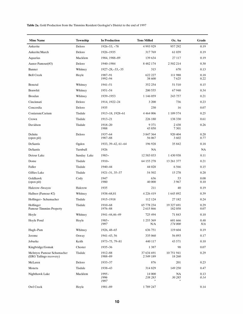
Table 2a. Gold Production from the Timmins Resident Geologist’s District to the end of 1997
Mine Name Township In Production Tons Milled Oz. Au Grade
Ankerite Deloro 1926--53, --78 4 993 929 957 292 0.19
Ankerite/March Deloro 1926--1935 317 769 61 039 0.19
Aquarius Macklem 1984, 1988--89 139 634 27 117 0.19
Aunor Pamour(#3) Deloro 1940--1984 8 482 174 2 502 214 0.30
Banner Whitney 1927--28,--33,--35 315 670 0.13
Bell Creek Hoyle 1987--911992--94
622 22738 600
111 9887 625
0.180.22
Bonetal Whitney 1941--51 352 254 51 510 0.15
Bonwhit Whitney 1951--54 200 555 67 940 0.34
Broulan Whitney 1939--1953 1 146 059 243 757 0.21
Cincinnati Deloro 1914, 1922--24 3 200 736 0.23
Concordia Deloro 1935 230 16 0.07
Coniarum/Carium Tisdale 1913--18, 1928--61 4 464 006 1 109 574 0.25
Crown Tisdale 1913--21 226 180 138 330 0.61
Davidson Tisdale 1918--201988
9 37143 850
2 4387 301
0.26
Delnite(open pit)
Deloro 1937--641987--88
3 847 36456 067
920 4043 602
0.200.77
DeSantis Ogden 1933, 39--42, 61--64 196 928 35 842 0.18
DeSantis Turnbull 1926 NA NA
Detour Lake Sunday Lake 1983-- 12 583 033 1 430 938 0.11
Dome Tisdale 1910-- 64 155 278 13 261 377 0.21
Fuller Tisdale 1940--44 44 028 6 566 0.15
Gillies Lake Tisdale 1921--31, 35--37 54 502 15 278 0.28
Goldhawk(open pit)
Cody 19471980
63640 000
533 967
0.080.10
Halcrow--Swayze Halcrow 1935 211 40 0.19
Hallnor (Pamour #2) Whitney 1938--68,81 4 226 419 1 645 892 0.39
Hollinger-- Schumacher Tisdale 1915--1918 112 124 27 182 0.24
HollingerPamour Timmins Property
Tisdale 1910--681976--88
65 778 2342 615 866
19 327 691182 058
0.290.07
Hoyle Whitney 1941--44,46--49 725 494 71 843 0.10
Hoyle Pond Hoyle 1985--1997
1 255 369N/A
601 666174 000
0.48N/A
Hugh--Pam Whitney 1926, 48--65 636 751 119 604 0.19
Jerome Osway 1941--43, 56 335 060 56 893 0.17
Joburke Keith 1973--75, 79--81 440 117 43 571 0.10
Kingbridge/Gomak Chester 1935--36 1 387 98 0.07
McIntyre Pamour Schumacher(ERG Tailings recovery)
Tisdale 1912--881988--89
37 634 6912 549 189
10 751 94118 260
0.29
McLaren Deloro 1933--37 876 201 0.23
Moneta Tisdale 1938--43 314 829 149 250 0.47
Nighthawk Lake Macklem 1995--19961997
14 000238 283
*
NA30 285
*
0.130.14
Owl Creek Hoyle 1981--89 1 789 247 0.14

11
Table 2a. cont’d. Gold Production from the Timmins Resident Geologist’s District to the end of 1997
Mine Name Township In Production Tons Milled Oz. Au Grade
Pamour #1 (Incl. pits 3, 4 & 7) Whitney 1936--1997
51 347 681*
4 654 260*
0.09
Porcupine Peninsular Cody 1924--27,--40,--47 99 688 27 354 0.27
Preston Tisdale 1938--68 6 284 405 1 539 355 0.24
Preston NY Tisdale 1933 2 800 153 0.05
Preston/Porcupine Pet Deloro 1914--15 NA 314
Preston/Porphyry Hill Deloro 1913--15 46 312 6.78
Reef Mine Whitney 1915--65 2 144 507 498 932 0.23
St. Andrew Goldfields Stock 1989--94 591 736 95 032 0.16
Tionaga/Smith Thorne Horwood 1938--39 6 653 2 299 0.35
Tisdale Ankerite Tisdale 1952 14 655 2 236 0.15
Tommy Burns/ Arcadia Shaw 1917 21 14 0.28
Vipond Tisdale 1911--41 1 565 218 414 367 0.26
* Only total figure for production from all Royal Oak sites available; see Table 2.Notes: Preliminary production figures for 1997 are shown in Italics
Grade = oz per ton Au
Table 2b. Base Metal Production from the Timmins Resident Geologist’s District to the end of 1997
Mine Name Township In Production Ore Milled Grades
Alexo Dundonald 1912--191943--44
51 857 tons4 923 tons
4.5% Ni, 0.55% Cu
Canadian Jamieson Godfrey 1966--71 816 173 tons 2.44% Cu, 4.22% Zn
Jameland Jamieson 1969--72 509 356 tons 0.99% Cu, 0.88% Zn
Kam Kotia Robb 1943--441961--72
6.6 Mtons 1.1% Cu, 1.17% Zn,0.10 oz/T Ag
Kidd Creek Kidd 1966-- 124.8 Mtons 2.38% Cu, 6.66% Zn,0.27% Pb, 83 g/t Ag
Langmuir #1 Langmuir 1990--91 111 502 tons 1.74% Ni
Langmuir #2 Langmuir 1972--78 1.1 Mtons 1.43% Ni
McIntyre Tisdale 1963--82 10 Mtons 0.67% Cu
Redstone Eldorado 1989--921995--96
294 895 tons10 228 tons
2.4% Ni1.7% Ni
United Obalski Godfrey 1966 Produced 240tons Cu
concentrate
ECHO BAY MINES LTD. -- AQUARIUS PROJECT
The Aquarius project is located in Macklem Township, 36 km east of Timmins. Access is by wayof a secondary road leading south from Hwy 101 for 2 km to the mine site. The Aquarius is a formerunderground gold mine that produced 27 117 ounces of gold in 1984 and 1988 to 1989. At that time,the mine was owned and operated by Asarco Exploration Company of Canada. Asarco began explor-ing the near surface, open pit potential of the property and then sold the property to Echo Bay OntarioLtd. in 1995. A 1996 feasibility study of the property by Echo Bay determined a gold resource of 1277 000 ounces contained in 19.7 million tons of ore could be recovered by open pit mining.
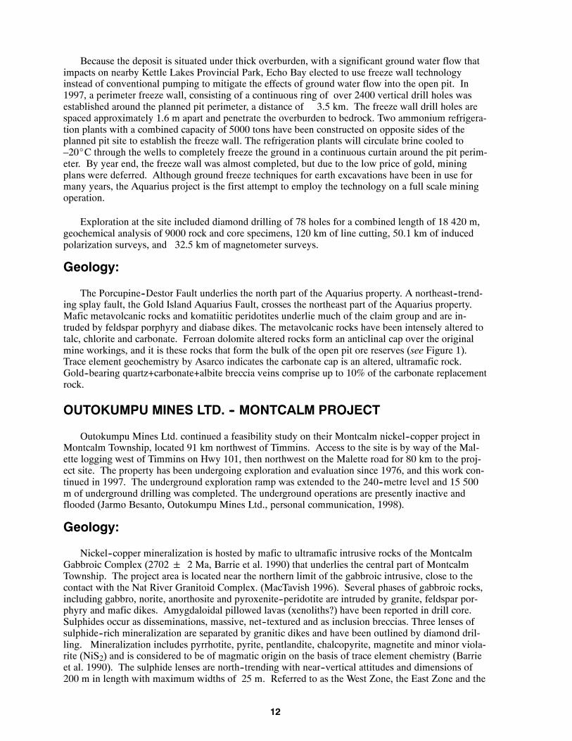
12
Because the deposit is situated under thick overburden, with a significant ground water flow thatimpacts on nearby Kettle Lakes Provincial Park, Echo Bay elected to use freeze wall technologyinstead of conventional pumping to mitigate the effects of ground water flow into the open pit. In1997, a perimeter freeze wall, consisting of a continuous ring of over 2400 vertical drill holes wasestablished around the planned pit perimeter, a distance of 3.5 km. The freeze wall drill holes arespaced approximately 1.6 m apart and penetrate the overburden to bedrock. Two ammonium refrigera-tion plants with a combined capacity of 5000 tons have been constructed on opposite sides of theplanned pit site to establish the freeze wall. The refrigeration plants will circulate brine cooled to–20_C through the wells to completely freeze the ground in a continuous curtain around the pit perim-eter. By year end, the freeze wall was almost completed, but due to the low price of gold, miningplans were deferred. Although ground freeze techniques for earth excavations have been in use formany years, the Aquarius project is the first attempt to employ the technology on a full scale miningoperation.
Exploration at the site included diamond drilling of 78 holes for a combined length of 18 420 m,geochemical analysis of 9000 rock and core specimens, 120 km of line cutting, 50.1 km of inducedpolarization surveys, and 32.5 km of magnetometer surveys.
Geology:
The Porcupine--Destor Fault underlies the north part of the Aquarius property. A northeast--trend-ing splay fault, the Gold Island Aquarius Fault, crosses the northeast part of the Aquarius property.Mafic metavolcanic rocks and komatiitic peridotites underlie much of the claim group and are in-truded by feldspar porphyry and diabase dikes. The metavolcanic rocks have been intensely altered totalc, chlorite and carbonate. Ferroan dolomite altered rocks form an anticlinal cap over the originalmine workings, and it is these rocks that form the bulk of the open pit ore reserves (see Figure 1).Trace element geochemistry by Asarco indicates the carbonate cap is an altered, ultramafic rock.Gold--bearing quartz+carbonate+albite breccia veins comprise up to 10% of the carbonate replacementrock.
OUTOKUMPU MINES LTD. -- MONTCALM PROJECT
Outokumpu Mines Ltd. continued a feasibility study on their Montcalm nickel--copper project inMontcalm Township, located 91 km northwest of Timmins. Access to the site is by way of the Mal-ette logging west of Timmins on Hwy 101, then northwest on the Malette road for 80 km to the proj-ect site. The property has been undergoing exploration and evaluation since 1976, and this work con-tinued in 1997. The underground exploration ramp was extended to the 240--metre level and 15 500m of underground drilling was completed. The underground operations are presently inactive andflooded (Jarmo Besanto, Outokumpu Mines Ltd., personal communication, 1998).
Geology:
Nickel--copper mineralization is hosted by mafic to ultramafic intrusive rocks of the MontcalmGabbroic Complex (2702 2 Ma, Barrie et al. 1990) that underlies the central part of MontcalmTownship. The project area is located near the northern limit of the gabbroic intrusive, close to thecontact with the Nat River Granitoid Complex. (MacTavish 1996). Several phases of gabbroic rocks,including gabbro, norite, anorthosite and pyroxenite--peridotite are intruded by granite, feldspar por-phyry and mafic dikes. Amygdaloidal pillowed lavas (xenoliths?) have been reported in drill core.Sulphides occur as disseminations, massive, net--textured and as inclusion breccias. Three lenses ofsulphide--rich mineralization are separated by granitic dikes and have been outlined by diamond dril-ling. Mineralization includes pyrrhotite, pyrite, pentlandite, chalcopyrite, magnetite and minor viola-rite (NiS2) and is considered to be of magmatic origin on the basis of trace element chemistry (Barrieet al. 1990). The sulphide lenses are north--trending with near--vertical attitudes and dimensions of200 m in length with maximum widths of 25 m. Referred to as the West Zone, the East Zone and the

13
Deep Zone, the lenses are depicted in Figure 2. Outokumpu has calculated a mineral resource of 7.1million tonnes grading 1.54% Ni and 0.72% Cu.
ST. ANDREW GOLDFIELDS LTD. -- STOCK MINE
St. Andrew Goldfields Ltd. continued exploring the previously mined Stock Mine in Stock Town-ship which is the site of their 1000 ton per day custom milling operation. Underground drilling of themine workings focussed on developing continuity below existing mine workings to a depth of 500feet.
The Stock mill operated on a custom basis, treating ore from the Glimmer Mine, located in Hislopand Beatty townships, east of Matheson, in the Kirkland Lake District.
UNITED TEX--SOL MINES INC. -- CLAVOS PROPERTY
The Clavos property is located in the northwest part of Stock Township and the northeast part ofGerman Township.
Access to the site is by way of the Finn road, north from Hwy 101, east of Timmins. A 1997 dia-mond drill project increased the geological resource of the property to 1 750 048 tonnes grading 6.4grams per tonne. A total of 360 080 ounces of gold have been identified in the DL Zone (The OntarioProspector, 1998).
To date, 28 000 m of diamond drilling have been completed on the property in 340 holes. Thedrilling has outlined 4 parallel zones of gold mineralization with a strike length of 1680 m. Gold oc-curs along a geological contact between metasedimentary rocks and metavolcanic rocks. Host rocksare sericite altered over widths varying from 5 to 40 m. From south to north, the mineralized zonesare referred to as the Sediment Zone, the Contact Zone, the DL Zone and the Footwall Zone. Thebulk of the gold mineralization is contained by the DL and Footwall zones. Gold occurs both as vis-ible gold and associated with pyrite mineralization. Minor arsenopyrite has been observed in the dia-mond drill core (Ed Ludwig, United Tex--Sol Mines Inc., personal communication, 1998).
Figure 1. Simplified geology of the Aquarius project, modified from Echo Bay Mines Ltd.

14
Figure 2. Sketch of mineralized zones, Montcalm project, modified from Outokumpu Mines Ltd..
VEDRON GOLD INC. -- FULLER ZONE
Vedron Gold Inc. explored their 58 claim, Vedron--Buffalo Ankerite property in Tisdale and Delo-ro townships. A gold resource of 614 092 ounces of gold grading 0.216 ounce per ton gold has beendelineated on the Fuller Zone, where a ramp has been excavated to the 650--foot level. In 1997, dia-mond drilling included 8 holes totaling 16 993 feet. The drilling was the second phase of an explora-tion program designed to test the continuation of previously outlined gold mineralization between1600 feet and 2500 feet below surface. A longitudinal sketch of the property is presented in Figure 3.Vedron Gold completed geophysical surveys over 48 km of grid lines on their Romfield South Zone inDeloro Township.
YOUNG -- SHANNON GOLD MINES LIMITED -- CHESTER TOWNSHIP
Young – Shannon Gold Mines Limited holds 11 patented claims in Chester Township, in theSwayze greenstone belt. The property is located approximately 95 km southwest of Timmins and isaccessed by secondary road from Highway 144. Underground exploration and development on theproperty has outlined a mineral resource of 695 787 tons with a grade of 0.344 ounces per ton gold(Canadian Mines Handbook, 1997--98).

15
Exploration Activity
Exploration activity, known to have been performed in the district is presented in Table 4 and onFigures 5e, 5f and 6. More detailed information on select exploration projects is described below.
BLACK PEARL MINERALS INC. -- NICKEL OFFSETS PROJECT
The Nickel Offsets property in Tully Township includes 16 contiguous patented claims. Theproperty is located approximately 30 km northeast of Timmins city centre. Access is by way ofHighway 655, to Buskegou Road for 12 km to the site. The property is blanketed by a mantle of gla-cial overburden 30 to 50 m thick.
Gold mineralization was discovered by McIntyre Porcupine Mines in 1968. Cromarty Explora-tion Company Ltd. did follow--up diamond drilling on the property in 1969 for McIntyre Mines. Thisdrilling amounted to 14 675 feet in 25 holes. Limited metallurgical testing of the mineralization wascompleted but no further work was done over the next ten years until Nickel Offsets Ltd. acquired theground. By 1982, Nickel Offsets outlined a gold resource of 370 650 tons grading 0.174 ounce perton gold. In 1987, Noranda Exploration Company Ltd. completed an exploration program on theproperty consisting of geophysical surveys and 17 265 feet of diamond drilling in 26 holes. In 1988,an additional 18 diamond drill holes, totalling 12 290 feet, were completed by Noranda.
Recent drilling by Black Pearl Minerals Inc. has better defined the mineralization and establishedthe geometry and geology of the deposit. In 1997, Black Pearl completed 46 636 feet of diamond dril-ling in 61 holes partly as infill drilling on 25 m centres within the Nickel Offsets gold deposit. Tendiamond drill holes tested induced polarization targets on the northern tuff horizon, resulting in thediscovery of the Murlin Zone, approximately one mile north of the Nickel Offsets deposit.
Geology:
The geology of the Nickel Offsets property consists of a 50 m wide band of east--trending, altereddacitic to andesitic or mafic “tuffs” bound by peridotite and komatiite flows to the south, and clasticmetasediments, including greywacke and graphitic argillite to the north. Ultramafic rocks are alteredto talc, chlorite, serpentine and carbonate. An inferred overturned, synclinal fold results in a similarbut reversed geological sequence on the north part of the property. The Main Zone is located on thesouth limb, while the Murlin Zone is located on the north limb of the syncline. In the Main Zone,gold mineralization occurs as crosscutting quartz and quartz + carbonate veins within the tuff unit.Visible gold occurs in the veins and pyrite is common. Minor chalcopyrite, sphalerite, arsenopyriteand galena have been reported in drill core but the presence of these sulphides does not appear to af-fect the gold tenor. Rare tellurides and tetrahedrite are noted. Diamond drilling indicates the tuff unitthins to the west.
CANABRAVA DIAMOND CORPORATION — KAP DIAMONDPROJECT
Canabrava Diamond Corporation, in conjunction with Paramount Ventures and Finance, com-pleted the acquisition of approximately 120 000 hectares of staked claims south of Kapuskasing. Thisproperty, known as the KAP Diamond Project consists of 4 property blocks within the KapuskasingStructural Zone. The company completed a high--resolution airborne magnetic and electromagnetic--VLF survey over the property in late 1997. Kimberlite targets identified from this survey will be tar-geted for ground follow up in 1998. Canabrava is also planning a comprehensive geochemical surveyfor kimberlite indicator minerals in the coming field season (Canabrava Diamond Corporation -- Para-mount Ventures and Finance, press release, December 1, 1997).

16
Figure 3. Longitudinal plan of the Fuller Zone, reproduced with permission of Vedron Gold Inc.

17
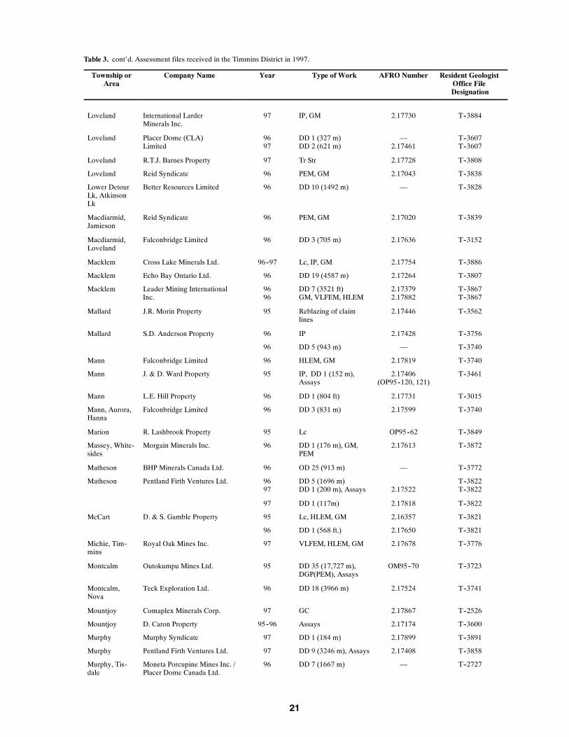
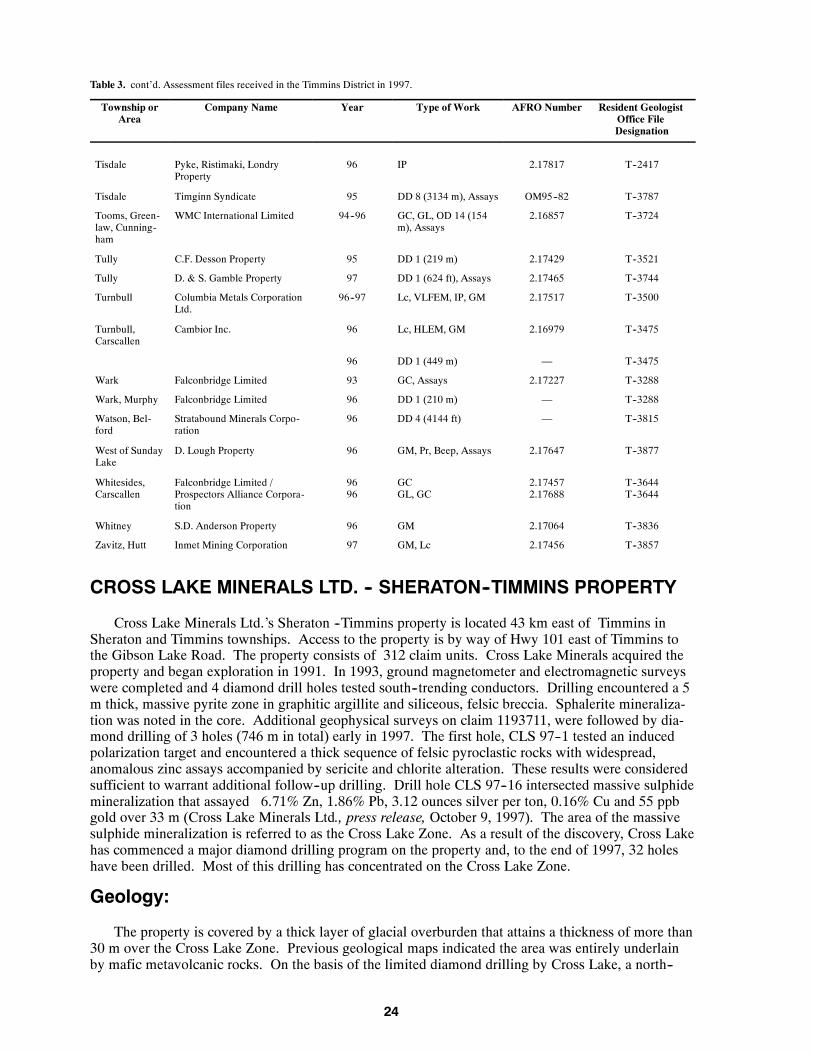
Table 3. Assessment files received in the Timmins District in 1997.
Abbreviations
Beep Beep Mat survey OD Overburden drilling
DD Diamond drilling OM Ontario Mineral Incentive Program
DGP Down--hole geophysics OP Ontario Prospectors Assistance Program
GC Geochemical survey PEM Pulse electromagnetic survey
GEM Ground electromagnetic survey Pr Prospecting
GL Geological survey Samp Sampling (other than bulk)
GM Ground magnetic survey Str Stripping
HLEM Horizontal loop electromagnetic survey TEM Transient electromagnetic in--loop survey
IM Industrial mineral testing and marketing Topo Topographic survey
IP Induced polarization survey Tr Trenching
Lc Linecutting VLFEM Very low frequency electromagnetic survey
Township orArea
Company Name Year Type of Work AFRO Number Resident GeologistOffice FileDesignation
BMA 524--852 KWG Resources Inc. 95 DD 1 (494 m),Petrology Report
2.16481 T--3659
BMA 527--853 KWG Resources Inc. 95 DD 2 (313 m) 2.17493 T--3659
BMA 528--853 KWG Resources Inc. 96 DD 1 (171 m) 2.17492 T--3659
BMA 528--861 KWG Resources Inc. 96 DD 1 (130 m) 2.17783 T--3894
BMA 531--851& 531--852
KWG Resources Inc. 96 DD 1 (304 m) 2.17531 T--3865
BMA 531--854 KWG Resources Inc. 95 DD 1 (74 m) 2.17491 T--3861
BMA 532--852 KWG Resources Inc. 95 DD 1 (383 m) 2.17494 T--3864
BMA 532--854 KWG Resources Inc. 95 DD 1 (178 m) 2.17519 T--3862
95 DD 2 (337 m) 2.17490 T--3862
BMA 533--852 KWG Resources Inc. 95 DD 1 (107 m) 2.17605 T--3863
95 DD 1 (206 m) 2.17501 T--3863
BMA 534--852 KWG Resources Inc. 95 DD 1 (164 m) 2.17521 T--3866
BMA 535--862 KWG Resources Inc. 95 DD 1 (127 m) 2.17773 T--3895
25 townships The Hanna MiningCompany
72--73 Samp, Assays Donated T--3840
Adams, Bart-lett, etc (9townships)
The Hanna Mining Company 75--77 Samp, Assays Donated T--3841
Aubin, Beck,etc (11 town-ships)
McIntyre Porcupine Mines 65 GC 63.4838/2 T--3842
Aurora, Cal-vert, Duff
Falconbridge Limited 96 GC 2.17658 T--3740
Beemer, En-glish
Driver Resources Inc. 95 IP, GM 2.17532 T--3873
Benton Cameco Corporation 95--96 GM, VLFEM, IP, Pr,Assays
2.17014 T--3750
Bond Cross Lake Minerals Ltd. 97 DD 1 (237 m) 2.17424 T--3274
Bond, Sheraton Cross Lake Minerals Ltd./Golden Knight Res. Inc.
96--9797
Lc, IP, GMHLEM
2.177552.17718
T--3274T--3576

18
Table 3. cont’d. Assessment files received in the Timmins District in 1997.
Township orArea
Company Name Year Type of Work AFRO Number Resident GeologistOffice FileDesignation
Bristol Copper Dome Mines Ltd. 97 GM, VLFEM, IP 2.17854 T--3817
Bristol Copper Dome Mines Ltd. /Poirier Option
97 Lc, VLFEM, GM 2.17356 T--3817
Bristol R. Poirier Property 90 Reblazing of claimlines
— T--3468
95 IP 2.17256 T--3468
Bristol, Cars-callen, Denton,Thorneloe
Battle Mountain Canada Ltd. 96 DD 9 (1960 m) 2.17460 T--3246
Brower P. Haire Property 96--97 GC, Topo 2.17833 T--3801
Carman, Lang-muir
Eclipse Mining Corporation 97 Tr, Samp, Assays 2.17801 T--3887
Carroll, Can-field
K. Cool, M. Kean Property 96 IM 2.17045 T--3543
Carscallen Golden Gate Resources Ltd. 97 GM, IP 2.17911 T--3818
Carscallen R.A. Plaunt Property 96 GL 2.17771 T--3798
Casselman P.P. Dirks Property 96 Str, Tr, Assays 2.17528 T--3876
Carscallen,Bristol
Band--Ore Resources Ltd. 97 GM, IP 2.17693 T--3616
Chester Bryan et al. Property 95 VLFEM 2.17807 T--3469
95 Str, Tr, GC, VLFEM OP95--112,113,114
T--3469
Chester, Yeo B. Duess & B. Durham Prop-erty
95 IP, Pr 2.17536(OP95--382)
T--3844
Clergue A. Salo Property 95 Report OP95--66 T--2759
Clergue Moneta Porcupine Mines Inc. 97 IP 2.17402, 2.17763 T--3777
Clergue S.D. Anderson Property 97 Lc, IP 2.17732 T--3885
Cody Anvil Resources Ltd. 97 IP, HLEM, GM, DD 5(981 m), Assays
2.17694 T--3882
Cody Moneta Porcupine Mines Inc. 9697
IPDD 2 (393 m),Assays
2.177612.17741
T--3764T--3764
Cody Royal Oak Mines Inc. 97 DD 16 (10,781 ft),Assays
2.17832 T--1573
Crawford, Lu-cas
Inco Ltd. 97 HLEM, GM, DD 1(178 m)
2.17682 T--3893
Deloro Asarco Exploration 97 Assays 2.17691 T--3602
Deloro Chas. R. Morgan Property 96 Str — T--2907
Deloro Grant--Collin Property 96 VLFEM, GM, GL 2.17266 T--3672
Deloro Placer Dome Inc. 97 DD 1 (145 ft) 2.17676 T--3832
Deloro Royal Oak Mines Inc. 97 Lc, GM, VLFEM 2.17865 T--3892
Deloro, Shaw Grant--Collin Property 95 VLFEM, GM, GL 2.17265 T--3672
Deloro, Shaw Placer Dome Canada Ltd. 96 GM 2.17042 T--3832
Denton Band--Ore Resources Ltd. 96 DD 12 (2432 m),Assays
2.17434 T--3784
Denton Black Pearl Minerals Inc. /Pentland Firth Ventures Ltd.
96 Lc, GM, HLEM 2.17696 T--3880
Denyes D.F. Patrie Property 96 IP, Lc 2.16964 T--3318

19
Table 3. cont’d. Assessment files received in the Timmins District in 1997.
Township orArea
Company Name Year Type of Work AFRO Number Resident GeologistOffice FileDesignation
Dore Inmet Mining Corporation 969697
IP, LcIP, LcDD 8 (2008 m), Assays
2.169452.172262.17466
T--3823T--3823T--3823
Eldorado,Adams, Deloro
Outokumpu Mines Ltd. 97 OD 51 (814 m) 2.17802 T--3658
English Cameco Corporation / Tri Ori-gin Exploration Ltd.
9696
Str, Tr, AssaysDD 7 (1354 m),Assays
2.175292.17489
T--3464T--3464
English Tri Origin Exploration Ltd. 95 GL, GC, Assays OM95--23 T--3464
English, Sem-ple
Cameco Corporation / Tri Ori-gin Exporation Ltd.
9697
Lc, GL, Pr, Samp, GCIP
2.174872.17689
T--3464T--3464
Esther M.L. Burton Property 96--97 DD 33 (3388 m),Assays
2.17845 T--1920
Evelyn A. Salo Property 96 DD 1 (647 ft) — T--3108
Evelyn S.D. Anderson Property 9696
Lc, HLEM, GMGL
2.169882.17523
T--3701T--3701
Evelyn D. & S. Gamble Property 96 DD 1 (300 ft), Assays 2.17455 T--3746
Fortune Jones -- Filo Property 95 DD 1 (350 ft), Str,Assays, Pr
2.17404(OP95--321, 322)
T--3847
Fox (Stimson) Anvil Resources Ltd. 95--96 DD 12 (2729 m),Assays
2.17834 T--3889
Fripp D. Tichinoff Property 97 IP 2.17177 T--3483
Fripp Moneta Porcupine Mines Inc. /McArthur Minerals
9696--97
DD 2 (525 m), AssaysDD 12 (1074 m),Assays
—2.17762
T--3806T--3806
Fripp,McKeown,Price
2973090 Canada Inc,/ Anglau-maque/Kalahari ResourcesInc.
97 GM, VLFEM 2.17486 T--3855
Garnet F. Ross Property 96 Str, Tr 2.17527 T--3729
Str, Tr 2.17526 T--3729
Godfrey Jones -- Bilenki Property 96 VLFEM, Reblazing ofclaim lines
2.16971 T--3681
Godfrey Moneta Porcupine Mines Inc. 95--96 DD 3 (751 m), Assays 2.16983 T--3546
96 GM, HLEM 2.17649 T--3546
97 IP 2.17601 T--3546
97 GM 2.17600 T--3546
Gowan Gowest AmalgamatedResources Ltd.
96 DD 3 (1024 m), Assays 2.17257 T--3803
Greenlaw 2973090 Canada Inc./ T. Ob-radovich Property
96 Pr, Beep, Samp,Assays
2.17412 T--3859
Halcrow D.F. Patrie Property 95 IP, GM, VLFEM 2.17433 T--3318
97 IP 2.17458 T--3318
Halcrow J.P. Patrie Property 95 IP, Assay 2.17447 T--3648
Halcrow,Tooms
Cameco Corporation 95 IP, GM, VLFEM,Assays
2.17014 T--3749
96 Tr — T--3749
Halliday Panterra Minerals Inc. 96 VLFEM, GM, GL,Samp, Pr, Assays
2.17533 T--3853

20
Table 3. cont’d. Assessment files received in the Timmins District in 1997.
Township orArea
Company Name Year Type of Work AFRO Number Resident GeologistOffice FileDesignation
Halliday Panterra Minerals Inc. / C.Pegg Property
97 DD 5 (1073m), Assays 2.17518 T--3853
Heenan Morin – Ross Property 91 Pr, Tr, Samp, Assays OP91--245, 242 T--3879
Heenan D. Mullen Property 95 DD 1 (64 m) OP95--266 T--3564
Horwood D. Morin Property 95 Str, Tr, Assays 2.17844(OP95--330)
T--3505
97 Str, Tr 2.17699 T--3505
Horwood Haddington Resources Ltd. 95 DD 10 (1795 m) 2.17263 T--3710
Horwood Morgain Minerals Inc. 95--96 IP, VLFEM, GM 2.17057 T--3830
96 DD 14 (2355 m) — T--3830
Horwood Ross -- Lalonde Property 95 Tr, Samp, Assays OP95--61,166,167
T--3851
Hoyle Black Hawk Mining Inc. 95 DD 16 (2987 m),Assays
OM95--114 T--3852
Hoyle Pentland Firth Ventures Ltd. 97 DD 2 (749 m), Assays 2.17431 T--3757
Ivanhoe D. Morin Property 95 Pr, Assays OP95--330 T--3846
96 Pr, Mechanical 2.17495 T--3846
Ivanhoe J.R. Morin Property 95 Pr, Assays 2.17453 T--3870
96 VLFEM, GM, Pr,Assays
2.17445 T--3870
Jamieson, God-frey
Falconbridge Limited 96--97 HLEM, GC 2.17820 T--3467
Jessop Mountjoy Jessop Syndicate 96 DD 4 (1562 m) 2.17398 T--3209
Jessop The Jessop Syndicate 96 Lc, PEM, GM 2.17357 T--3209
Keefer Blackwater Gold Corporation 96 Lc, IP, GM 2.17062 T--3825
Keefer, Hillary W. Sims Property 96 GL, Samp, Assays, Str 2.17485 T--3369
Keith D. Morin Property 94 Str — T--3779
Keith Marshall Minerals Corp 96 DD 12 (1291 m) — T--2776
Keith Penn--Gold Resources Inc./Can. Golden Dragon Re-sources Ltd.
96 GM 2.17058 T--3834
Kenogaming D. Morin Property 95 Pr, Assays, GM,VLFEM, HLEM
OP95--330 T--2726
Kenogaming Eastmain Resources Inc. 95 IP, GL OM95--49 T--3752
Kenogaming K. Filo Property / Orezone Re-sources Inc.
96 GL 2.17175 T--3759
Langmuir Black Pearl Minerals Inc. 97 GL 2.17698 T--3883
Langmuir D. Meunier Property 97 DD 3 (768 m), Assays 2.17680 T--2951
Langmuir Kalahari Resources Inc. 92, 96 VLFEM, IP, HLEM 2.17016 T--3829
Langmuir Outokumpu Mines Ltd. 96 DD 4 (876 m) 2.17422 T--3789
96 HLEM, GM 2.17520 T--3789
Little D. & S. Gamble Property 96--97 DD 1 (160 m), Assays 2.17454 T--3745
Loveland Atna Resources Ltd. 97 GM 2.17401 T--3871
Loveland D. Meunier Property 96 Lc,VLFEM, GM 2.17172 T--3381
97 Str — T--3381
Loveland Driver Resources Inc. 95--96 IP, GM, DD 6 (950 m) 2.17171 T--3875
21
Table 3. cont’d. Assessment files received in the Timmins District in 1997.
Township orArea
Company Name Year Type of Work AFRO Number Resident GeologistOffice FileDesignation
Loveland International LarderMinerals Inc.
97 IP, GM 2.17730 T--3884
Loveland Placer Dome (CLA)Limited
9697
DD 1 (327 m)DD 2 (621 m)
—2.17461
T--3607T--3607
Loveland R.T.J. Barnes Property 97 Tr Str 2.17728 T--3808
Loveland Reid Syndicate 96 PEM, GM 2.17043 T--3838
Lower DetourLk, AtkinsonLk
Better Resources Limited 96 DD 10 (1492 m) — T--3828
Macdiarmid,Jamieson
Reid Syndicate 96 PEM, GM 2.17020 T--3839
Macdiarmid,Loveland
Falconbridge Limited 96 DD 3 (705 m) 2.17636 T--3152
Macklem Cross Lake Minerals Ltd. 96--97 Lc, IP, GM 2.17754 T--3886
Macklem Echo Bay Ontario Ltd. 96 DD 19 (4587 m) 2.17264 T--3807
Macklem Leader Mining InternationalInc.
9696
DD 7 (3521 ft)GM, VLFEM, HLEM
2.173792.17882
T--3867T--3867
Mallard J.R. Morin Property 95 Reblazing of claimlines
2.17446 T--3562
Mallard S.D. Anderson Property 96 IP 2.17428 T--3756
96 DD 5 (943 m) — T--3740
Mann Falconbridge Limited 96 HLEM, GM 2.17819 T--3740
Mann J. & D. Ward Property 95 IP, DD 1 (152 m),Assays
2.17406(OP95--120, 121)
T--3461
Mann L.E. Hill Property 96 DD 1 (804 ft) 2.17731 T--3015
Mann, Aurora,Hanna
Falconbridge Limited 96 DD 3 (831 m) 2.17599 T--3740
Marion R. Lashbrook Property 95 Lc OP95--62 T--3849
Massey, White-sides
Morgain Minerals Inc. 96 DD 1 (176 m), GM,PEM
2.17613 T--3872
Matheson BHP Minerals Canada Ltd. 96 OD 25 (913 m) — T--3772
Matheson Pentland Firth Ventures Ltd. 9697
DD 5 (1696 m)DD 1 (200 m), Assays 2.17522
T--3822T--3822
97 DD 1 (117m) 2.17818 T--3822
McCart D. & S. Gamble Property 95 Lc, HLEM, GM 2.16357 T--3821
96 DD 1 (568 ft.) 2.17650 T--3821
Michie, Tim-mins
Royal Oak Mines Inc. 97 VLFEM, HLEM, GM 2.17678 T--3776
Montcalm Outokumpu Mines Ltd. 95 DD 35 (17,727 m),DGP(PEM), Assays
OM95--70 T--3723
Montcalm,Nova
Teck Exploration Ltd. 96 DD 18 (3966 m) 2.17524 T--3741
Mountjoy Comaplex Minerals Corp. 97 GC 2.17867 T--2526
Mountjoy D. Caron Property 95--96 Assays 2.17174 T--3600
Murphy Murphy Syndicate 97 DD 1 (184 m) 2.17899 T--3891
Murphy Pentland Firth Ventures Ltd. 97 DD 9 (3246 m), Assays 2.17408 T--3858
Murphy, Tis-dale
Moneta Porcupine Mines Inc. /Placer Dome Canada Ltd.
96 DD 7 (1667 m) — T--2727

22
Table 3. cont’d. Assessment files received in the Timmins District in 1997.
Township orArea
Company Name Year Type of Work AFRO Number Resident GeologistOffice FileDesignation
Murphy, Tis-dale
Placer Dome Canada Ltd. 96 HLEM, GM 2.17061 T--3835
Ogden I.A. Lajeunesse Property 96 Pr, Reblazing of claimlines
2.17614 T--3874
Ogden S.Anderson / Willow Re-sources
96--97 Lc, GM 2.17262 T--3697
Osway, Esther,Garnet, Benton,Mallard, Heen-an, Dore, Ca-rew, Joffre
M. Charette Property 95 GL, Samp, Assays OP95--240 T--3845
Penhorwood B. Durham Property 96 Str — T--3774
Penhorwood Can. Golden DragonResources Ltd. /BrownstoneInvestments
96 IP, GM 2.17060 T--2722
Penhorwood La Societe de Gestion Mas-kours Inc.(Roseval)
96 GM 2.16965 T--3237
Penhorwood Otis J. Exploration 95 IP Sections OM95--22 T--3774
Penhorwood,Reeves
Can. Golden DragonResources Ltd. / BrownstoneInvestments
96 Lc, HLEM, GM 2.17059 T--2722
Pharand E. Mord Property 96 DD 2 (461 ft), Assays,Pr, Samp
2.17435 T--3489
Potter, Sangster Noranda Mining & Explora-tion
95 GL 2.17772 T--3763
Price Inmet Mining Corporation 96 DD 8 (2179 m) 2.17500 T--3809
Price, Ogden,Thorneloe
Inmet Mining Corporation 96 IP 2.16987 T--3809
Prosser Eastmain Resources Inc. 95 IP 2.16980 T--3831
Prosser Falconbridge Limited 96 GC 2.17013 T--3162
Prosser, Wark Eastmain Resources Inc. 95 GM, HLEM, TEM, IP,DD 2 (469 m), Assays
OM95--50 T--3831
Reeves Cross Lake Minerals Ltd. 96 HLEM, IP, GM, DD 3(725 m)
2.17044 T--3837
96 DD 2 (350 m), Assays 2.17687 T--3837
Reeves East West ResourceCorporation
96 Lc, HLEM, GM 2.17056 T--3833
Reeves Elcajun Resources Ltd. 95 Tr — T--3628
95--96 Pr 2.17176 T--3628
96 Tr — T--3628
Reeves + 7townships
Troup & Otton Property 92 Pr, Samp, Assays, GC OP92--558,559 T--3878
Reid McChip Resources Inc. 95 DD 2 (568 m), Assays OM95--83 T--3519
Reid Reid Syndicate 96 PEM, GM 2.16966 T--3802
96 GM 2.16978 T--3802
Reid, Carnegie Comaplex Minerals Corp. /Comstate Resources
96 DD 3 (722 m), Assays 2.17258 T--3154
Robb Falconbridge Limited 96 DD 1 (486 m) 2.17499 T--3189
Robb G. Kerr Property 97 GM 2.17690 T--3881

23
Table 3. cont’d. Assessment files received in the Timmins District in 1997.
Township orArea
Company Name Year Type of Work AFRO Number Resident GeologistOffice FileDesignation
Robb, Jamie-son, Godfrey
Falconbridge Limited 96 DD 3 (994 m) 2.17648 T--3189
Sewell Cross Lake Minerals Ltd. 96 IP, GM, Lc 2.16962 T--3824
96 GL 2.16963 T--3824
Sewell Driver Resources Inc. 95 DD 6 (950 m) 2.17804 T--3791
Sewell Sewell Mining Corporation /M. Caron Property
96 Lc, IP, GM 2.17497 T--3868
Shaw Outokumpu Mines Ltd. 96 DD 2 (229 m) 2.17423 T--3848
96 GM 2.17578 T--3848
Shaw R. Collins Property 95 Tr, GL OP95--97 T--3850
Sheraton Cross Lake Minerals Ltd. 97 DD 3 (747 m), Assays 2.17719 T--3576
97 IP, HLEM, GM 2.17720 T--3576
Slack J.P. Arsenault Property 96 Manual 2.17525 T--2363
Sothman Abitibi Mining Corp 95--96 DD 14 (1681 m) — T--3820
South of RidgeLake
D. McKinnon Property 97 IM 2.17496 T--3860
Stock St. Andrew Goldfields Ltd. 96 DD 1 (455 m) 2.17795 T--3088
Sunday Lake Gowest AmalgamatedResources Ltd.
97 HLEM, GM 2.17808 T--3888
Sunday Lake Cyprus Canada Inc. 97 Lc, IP, GM, DD 1(138 m), Assays
2.17530 T--3854
Sunday Lake,West of
Pelangio--Larder Mines Limit-ed
97 DD 4 (629 m), Assays 2.17464 T--3856
Sunday Lk, W.of, Sunday Lk.
Placer Dome Ltd. 96 DD 6 (853 m), Assays 2.17450 T--2349
Swayze J.P. Patrie et al Property 96 IP, Pr 2.17430 T--3869
Thorburn Noranda Mining & Explora-tion
96 DD 1 (783 m) — T--3236
Thorneloe Band--Ore Resources Ltd. 96 DD 15 (4053 m),Assays
2.17757 T--3616
Thorneloe Band--Ore Resources Ltd. /Abitibi Mining Corp.
96 DD 11 (2758 m),Assays
2.17224 T--3616
Thorneloe Comaplex Minerals Corp. 96 DD 1 (215 m) — T--3826
Thorneloe Meranto Technology Inc. 96 Lc, IP, GM, VLFEM 2.17888 T--3890
Thorneloe,Bristol
Band--Ore Resources Ltd. 96--97 IP, GM 2.17760 T--3616
Thorneloe,Bristol
Band--Ore Resources Ltd. / Se-dex Mining Corp.
96 DD 6 (911 m), Assays 2.17225 T--3616
Timmins Royal Oak Mines Inc. 96 GC 2.17063 T--3776
96 DD 4 (1198 m), Assays — T--3776
Timmins,Sheraton
Haddington Resources Ltd. 97 GL, Assays 2.17758 T--3805
Tisdale D. & P. Meunier Property 95 DD 1 (913 ft) OP95--253,254 T--2956
Tisdale Pyke -- Londry Property 94 GM, VLFEM, HLEM,IP
2.17015 T--2417
Tisdale D.R. Pyke Property 97 IP 2.17218 T--3569
Tisdale Pentland Firth Ventures Ltd. 96 DD 2 (601 m) — T--3827
24
Table 3. cont’d. Assessment files received in the Timmins District in 1997.
Township orArea
Company Name Year Type of Work AFRO Number Resident GeologistOffice FileDesignation
Tisdale Pyke, Ristimaki, LondryProperty
96 IP 2.17817 T--2417
Tisdale Timginn Syndicate 95 DD 8 (3134 m), Assays OM95--82 T--3787
Tooms, Green-law, Cunning-ham
WMC International Limited 94--96 GC, GL, OD 14 (154m), Assays
2.16857 T--3724
Tully C.F. Desson Property 95 DD 1 (219 m) 2.17429 T--3521
Tully D. & S. Gamble Property 97 DD 1 (624 ft), Assays 2.17465 T--3744
Turnbull Columbia Metals CorporationLtd.
96--97 Lc, VLFEM, IP, GM 2.17517 T--3500
Turnbull,Carscallen
Cambior Inc. 96 Lc, HLEM, GM 2.16979 T--3475
96 DD 1 (449 m) — T--3475
Wark Falconbridge Limited 93 GC, Assays 2.17227 T--3288
Wark, Murphy Falconbridge Limited 96 DD 1 (210 m) — T--3288
Watson, Bel-ford
Stratabound Minerals Corpo-ration
96 DD 4 (4144 ft) — T--3815
West of SundayLake
D. Lough Property 96 GM, Pr, Beep, Assays 2.17647 T--3877
Whitesides,Carscallen
Falconbridge Limited /Prospectors Alliance Corpora-tion
9696
GCGL, GC
2.174572.17688
T--3644T--3644
Whitney S.D. Anderson Property 96 GM 2.17064 T--3836
Zavitz, Hutt Inmet Mining Corporation 97 GM, Lc 2.17456 T--3857
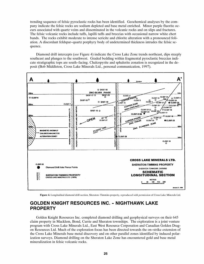
CROSS LAKE MINERALS LTD. -- SHERATON--TIMMINS PROPERTY
Cross Lake Minerals Ltd.’s Sheraton --Timmins property is located 43 km east of Timmins inSheraton and Timmins townships. Access to the property is by way of Hwy 101 east of Timmins tothe Gibson Lake Road. The property consists of 312 claim units. Cross Lake Minerals acquired theproperty and began exploration in 1991. In 1993, ground magnetometer and electromagnetic surveyswere completed and 4 diamond drill holes tested south--trending conductors. Drilling encountered a 5m thick, massive pyrite zone in graphitic argillite and siliceous, felsic breccia. Sphalerite mineraliza-tion was noted in the core. Additional geophysical surveys on claim 1193711, were followed by dia-mond drilling of 3 holes (746 m in total) early in 1997. The first hole, CLS 97--1 tested an inducedpolarization target and encountered a thick sequence of felsic pyroclastic rocks with widespread,anomalous zinc assays accompanied by sericite and chlorite alteration. These results were consideredsufficient to warrant additional follow--up drilling. Drill hole CLS 97--16 intersected massive sulphidemineralization that assayed 6.71% Zn, 1.86% Pb, 3.12 ounces silver per ton, 0.16% Cu and 55 ppbgold over 33 m (Cross Lake Minerals Ltd., press release, October 9, 1997). The area of the massivesulphide mineralization is referred to as the Cross Lake Zone. As a result of the discovery, Cross Lakehas commenced a major diamond drilling program on the property and, to the end of 1997, 32 holeshave been drilled. Most of this drilling has concentrated on the Cross Lake Zone.
Geology:
The property is covered by a thick layer of glacial overburden that attains a thickness of more than30 m over the Cross Lake Zone. Previous geological maps indicated the area was entirely underlainby mafic metavolcanic rocks. On the basis of the limited diamond drilling by Cross Lake, a north--
25
trending sequence of felsic pyroclastic rocks has been identified. Geochemical analyses by the com-pany indicate the felsic rocks are sodium depleted and base metal enriched. Minor purple fluorite oc-curs associated with quartz veins and disseminated in the volcanic rocks and on slips and fractures.The felsic volcanic rocks include tuffs, lapilli tuffs and breccias with occasional narrow white chertbands. The rocks exhibit moderate to intense sericite and chlorite alteration with a pronounced foli-ation. A discordant feldspar--quartz porphyry body of undetermined thickness intrudes the felsic se-quence.
Diamond drill intercepts (see Figure 4) indicate the Cross Lake Zone trends northeast, dips steeplysoutheast and plunges to the southwest. Graded bedding within fragmental pyroclastic breccias indi-cate stratigraphic tops are south--facing. Chalcopyrite and sphalerite zonation is recognized in the de-posit (Bob Middleton, Cross Lake Minerals Ltd., personal communication, 1997).
Figure 4. Longitudinal diamond drill section, Sheraton–Timmins property, reproduced with permission of Cross Lake Minerals Ltd.
GOLDEN KNIGHT RESOURCES INC. -- NIGHTHAWK LAKEPROPERTY
Golden Knight Resources Inc. completed diamond drilling and geophysical surveys on their 645claim property in Macklem, Bond, Currie and Sheraton townships. The exploration is a joint ventureprogram with Cross Lake Minerals Ltd., East West Resource Corporation and Canadian Golden Drag-on Resources Ltd. Much of the exploration focus has been directed towards the on--strike extension ofthe Cross Lake Minerals base metal discovery and on other parallel zones identified by induced polar-ization surveys. Diamond drilling on the Sheraton Lake Zone has encountered gold and base metalmineralization in felsic volcanic rocks.

26
HADDINGTON RESOURCES LTD., SILVERSTONE RESOURCES LTD.-- KALTWASSER PROPERTY
The Kaltwasser property is situated at the intersection of Sheraton, Timmins and Egan townships,approximately 50 km east of Timmins city centre. Access to the property is by way of the GibsonLake Road, south from Hwy 101. Haddington Resources Ltd. and Silverstone Resources Ltd. carriedout a joint venture exploration of the property consisting of induced polarization surveys and diamonddrilling. Five diamond drill holes tested IP conductors over a strike length of 1 km, approximately 5km southeast of the recent base metal discovery in Sheraton Township by Cross Lake Minerals Ltd.Felsic volcaniclastic rocks and pyrite--bearing, rhyolite breccia, up to 55.5 m thick, with elevated lev-els of zinc, copper and gold were encountered in the drill program (Haddington Resources Ltd., Silv-erstone Resources Ltd., press release, October 29, 1997).
PENTLAND FIRTH VENTURES LTD. -- MARLHILL MINE PROJECT
The Marlhill Mine Project is located in Hoyle Township, 800 m north of the Bell Creek Mine.Previous exploration on the site has defined and extended a number of gold--bearing zones. The M1Vein was mined between 1989 and 1991 to a depth of 120 m. Pentland Firth has been exploring be-neath the mine workings and has identified a gold resource of 199 000 ounces in 1.3 million tons ofmineralization grading 4.78 g/t gold (The Ontario Prospector, 1998). The property is presently inac-tive.
On the Schumacher III project, in Hoyle Township, Pentland Firth has outlined a gold resource of62 000 ounces in 670 000 tons of mineralization grading 2.89 g/t gold (The Ontario Prospector,1998).
Pentland Firth Ventures Ltd. completed geochemical surveys over their properties in Hoyle andMurphy townships.
PLACER DOME NORTH AMERICA LIMITED -- DETOUR LAKE AREA
Placer Dome North America Limited explored four properties in the Detour Lake greenstone beltoutside the Detour Lake Mine property. These included a joint venture project with Pelangio LarderMines Limited west of the Detour Lake Mine where 3 diamond drill holes, totalling 3739 m, werecompleted.
On the McAlpine Lake property, Placer Dome completed 3 new diamond drill holes and a dia-mond drill hole collared in 1996 was extended. The diamond drill program amounted to 1851 m.
The South Detour and Sunday Lake properties, situated south and east of the Detour Lake Mine,were optioned from Westmin Resources Limited. Diamond drilling of 16 holes totalling 4314 m ex-plored the South Detour property, and 50 km of line cutting and 45 km of induced polarization werecompleted on the Sunday Lake property.

27
Figure 5a. No exploration activity.

28
Figure 5b. No exploration activity.

29
Figure 5c. No exploration activity.

30
Figure 5d.No exploration activity

31
Figure 5e. Exploration activity, 1997.

32
Figure 5f.Mining and exploration activity, 1997.

33
Figure6.ExplorationActivity,1997

34
Table 4. Exploration activity in the Timmins District in 1997.
Abbreviations
AEM Airborne electromagnetic survey Mo Molybdenum
AM Airborne magnetic survey NA Data Not Available
Ag Silver Ni Nickel
Au Gold ODH Overburden drill hole(s)
BM Base metals Pb Lead
Cu Copper PEM Pulse electromagnetic survey
DD Diamond drilling PGM Platinum group metals
DGP Down--hole geophysics Pr Prospecting
GC Geochemical survey RES Resistivity survey
GL Geological Survey Samp Sampling (other than bulk)
GM Ground magnetic survey Str Stripping
HLEM Horizontal loop electromagnetic survey Topo Topographical survey
IM Industrial mineral testing and marketing Tr Trenching
IP Induced polarization survey VLFEM Very low frequency electromagnetic survey
Lc Linecutting Zn Zinc
No Company/Individual(Occurrence Name)
or Property
Township/Area(Commodity)
Exploration Activity
1 2973090 Canada Inc. / Anglaumaque /Kalahari Resources Inc.
Fripp, McKeown, Price (Au) GM, VLFEM
2 S. D. Anderson / Willow Resources Ogden (Au) Lc, GM
3 S. D. Anderson Property Clergue (Au) Lc, IP
4 Anvil Resources Ltd. Cody (Au) IP, HLEM, GM, DD 5 (981 m), Assays
5 Asarco Exploration Deloro (Au, Cu, Ag, PGM) Assays
6 Atna Resources Ltd. Loveland (NA) GM
7 Band--Ore Resources Ltd. Carscallen, Bristol (Au) GM, IP
8 Band--Ore Resources Ltd. Thorneloe, Bristol (Au) IP, GM
9 R.T.J. Barnes Property Loveland (NA) Tr, Str
10 Battle Mountain Gold Company Thorneloe, Bristol, Denton (Au) Lc, GM, IP, GL, DD 24 (7100 m)
11 Black Pearl Minerals Inc. Langmuir (Au, BM) GL
12 Black Pearl Minerals Inc. Tully (Au) DD 71 (54,792 ft)
13 Blue Emerald Resources Inc. Price (Au) GM, VLFEM
14 M.L. Burton Property Esther (Au) DD 33 (3388 m), Assays
15 Cameco Gold Inc./Tri Origin ExplorationLtd.
English, Semple (Au) Lc, GL, IP
16 Canabrava Diamond Corporation / Para-mount Ventures and Finance
Allenby, Cargill, Concobar, Kirkwall,Lerwick, Maude, Oscar, Shanly, Sta-ples, Stephansson, Sulman(diamonds)
AEM, AM
17 Comaplex Minerals Corp. Mountjoy (Au) GC
18 Copper Dome Mines Ltd. / Poirier Option Bristol (Au) Lc, VLFEM, GM, IP
19 Cross Lake Minerals Ltd. Macklem (Au) Lc, GM
20 Cross Lake Minerals Ltd. Sheraton (Zn, Cu, Au) DD 34, Assays, Lc, GM, IP
20 Cross Lake Minerals Ltd. / Golden KnightResources Inc.
Sheraton, Bond (Zn, Cu, Au) DD 27, IP, GM, HLEM, Assays
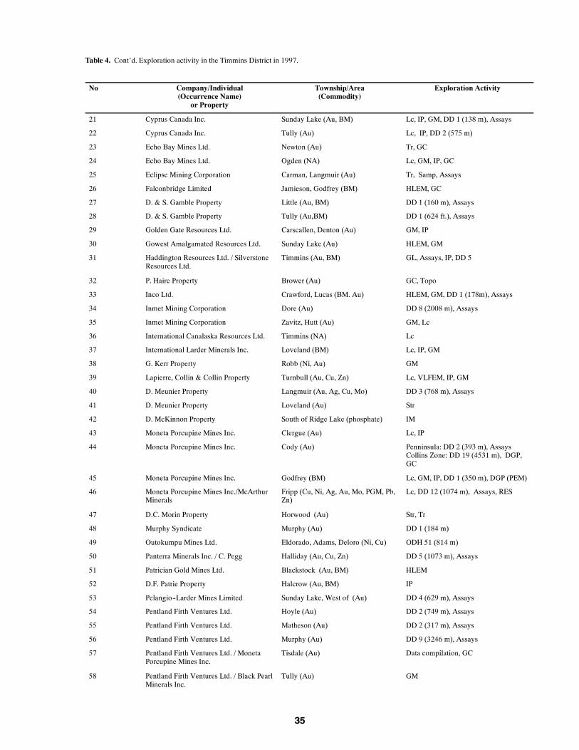
35
Table 4. Cont’d. Exploration activity in the Timmins District in 1997.
No Company/Individual(Occurrence Name)
or Property
Township/Area(Commodity)
Exploration Activity
21 Cyprus Canada Inc. Sunday Lake (Au, BM) Lc, IP, GM, DD 1 (138 m), Assays
22 Cyprus Canada Inc. Tully (Au) Lc, IP, DD 2 (575 m)
23 Echo Bay Mines Ltd. Newton (Au) Tr, GC
24 Echo Bay Mines Ltd. Ogden (NA) Lc, GM, IP, GC
25 Eclipse Mining Corporation Carman, Langmuir (Au) Tr, Samp, Assays
26 Falconbridge Limited Jamieson, Godfrey (BM) HLEM, GC
27 D. & S. Gamble Property Little (Au, BM) DD 1 (160 m), Assays
28 D. & S. Gamble Property Tully (Au,BM) DD 1 (624 ft.), Assays
29 Golden Gate Resources Ltd. Carscallen, Denton (Au) GM, IP
30 Gowest Amalgamated Resources Ltd. Sunday Lake (Au) HLEM, GM
31 Haddington Resources Ltd. / SilverstoneResources Ltd.
Timmins (Au, BM) GL, Assays, IP, DD 5
32 P. Haire Property Brower (Au) GC, Topo
33 Inco Ltd. Crawford, Lucas (BM. Au) HLEM, GM, DD 1 (178m), Assays
34 Inmet Mining Corporation Dore (Au) DD 8 (2008 m), Assays
35 Inmet Mining Corporation Zavitz, Hutt (Au) GM, Lc
36 International Canalaska Resources Ltd. Timmins (NA) Lc
37 International Larder Minerals Inc. Loveland (BM) Lc, IP, GM
38 G. Kerr Property Robb (Ni, Au) GM
39 Lapierre, Collin & Collin Property Turnbull (Au, Cu, Zn) Lc, VLFEM, IP, GM
40 D. Meunier Property Langmuir (Au, Ag, Cu, Mo) DD 3 (768 m), Assays
41 D. Meunier Property Loveland (Au) Str
42 D. McKinnon Property South of Ridge Lake (phosphate) IM
43 Moneta Porcupine Mines Inc. Clergue (Au) Lc, IP
44 Moneta Porcupine Mines Inc. Cody (Au) Penninsula: DD 2 (393 m), AssaysCollins Zone: DD 19 (4531 m), DGP,GC
45 Moneta Porcupine Mines Inc. Godfrey (BM) Lc, GM, IP, DD 1 (350 m), DGP (PEM)
46 Moneta Porcupine Mines Inc./McArthurMinerals
Fripp (Cu, Ni, Ag, Au, Mo, PGM, Pb,Zn)
Lc, DD 12 (1074 m), Assays, RES
47 D.C. Morin Property Horwood (Au) Str, Tr
48 Murphy Syndicate Murphy (Au) DD 1 (184 m)
49 Outokumpu Mines Ltd. Eldorado, Adams, Deloro (Ni, Cu) ODH 51 (814 m)
50 Panterra Minerals Inc. / C. Pegg Halliday (Au, Cu, Zn) DD 5 (1073 m), Assays
51 Patrician Gold Mines Ltd. Blackstock (Au, BM) HLEM
52 D.F. Patrie Property Halcrow (Au, BM) IP
53 Pelangio--Larder Mines Limited Sunday Lake, West of (Au) DD 4 (629 m), Assays
54 Pentland Firth Ventures Ltd. Hoyle (Au) DD 2 (749 m), Assays
55 Pentland Firth Ventures Ltd. Matheson (Au) DD 2 (317 m), Assays
56 Pentland Firth Ventures Ltd. Murphy (Au) DD 9 (3246 m), Assays
57 Pentland Firth Ventures Ltd. / MonetaPorcupine Mines Inc.
Tisdale (Au) Data compilation, GC
58 Pentland Firth Ventures Ltd. / Black PearlMinerals Inc.
Tully (Au) GM

36
Table 4. Cont’d. Exploration activity in the Timmins District in 1997.
No Company/Individual(Occurrence Name)
or Property
Township/Area(Commodity)
Exploration Activity
59 Pentland Firth Ventures Ltd. / Inmet Min-ing Corporation (Croxall – KangasProperty)
Thorneloe, Price, Ogden (Au) GM, IP
60 Placer Dome (CLA) Limited Loveland (Au) DD 2 (621 m)
61 Placer Dome (CLA) Limited Deloro (Au) DD 1 (145 ft.)
62 Placer Dome North America Limited /Pelangio--Larder Mines Limited
Sunday Lake, West of (Au) DD 3 (3739 m)
63 Placer Dome North America Limited(Gowest Amalgamated Resources Ltd.Option)
Sunday Lake, West of (Au) DD 3 (1851 m)
64 Placer Dome North America Limited(Westmin Option)
Lower Detour Lake (Au) DD 16 (4314 m)
65 Placer Dome North America Limited(Westmin Option)
Sunday Lake (Au) Lc, IP
66 Prospectors Alliance Corporation Bristol, Carscallen, Whitesides (Au) Str, Tr, GL, Samp, DD
67 D.R. Pyke Property Tisdale (Au) IP
68 Renaudat – Fournier Property Horwood (Au, BM) Str, Assays
69 Royal Oak Mines Inc. Cody (Au) DD 16 (10,781 ft), Assays
70 Royal Oak Mines Inc. Deloro (Au, BM) Lc, GM, VLFEM
71 Royal Oak Mines Inc. Michie, Timmins (Au) Lc, VLFEM, HLEM, GM, DD 1 (689 ft)
72* Royal Oak Mines Inc. Murphy (Au) DD 1 (608 ft)
73 Teck Exploration Ltd. Wark (BM) HLEM, DD 1 (110 m)
74 D. Tichinoff Property Fripp (Au, BM) IP
75 M. Tremblay Zavitz (BM) Pr
* Property 72 misplotted on Figure 6. Location in NW quarter of township not SW
PROSPECTORS ALLIANCE CORPORATION -- TIMMINS WESTPROPERTIES
Prospectors Alliance Corporation holds a 500 claim block with a 22 km length in Bristol, Carscal-len, and Whitesides townships. The company did stripping, trenching, mapping and sampling on theAllerston fault where several historic gold occurrences have been identified. The Jowsey Occurrence(see “Property Examinations”) was tested with a small drill program.
Prospectors Alliance Corporation and International Larder Minerals Inc. have joint ventured toexplore properties in the Kamiskotia area northwest of Timmins for base metal mineralization (TheOntario Prospector, 1998).

37
Land Use Planning Activity
Lands for Life is a new land use planning program initiated by the Ontario government which hasthe objective of identifying and mitigating varying land use practises throughout much of the prov-ince. Staff contributed to the mineral resource assessment of the land base in the Timmins District aspart of the Lands for Life process.

38
Resident Geologist Staff and Activities
As a result of Ministry reorganization, significant personnel changes occurred in the Timmins of-fice. Lorne Luhta vacated the Regional Resident Geologist position in May, and Pam Sangster de-parted to take up the Tweed based position of Regional Resident Geologist, Southern Ontario in Sep-tember. Brian Atkinson transferred from the Red Lake Resident Geologist position to serve as theRegional Resident Geologist for the Timmins District in June and also acquired supervisory responsi-bility for the Sault Ste. Marie District. Ann Wilson was appointed District Geologist and a secondposition of District Geologist remained vacant through the year. Reno Pressacco has been appointedto fill that position, commencing February 1998. Philip Hope was appointed Geological Assistant.Diane Draper serves as the Regional Support Geologist, responsible for the Earth Resources Land In-formation System (ERLIS). Dan Lachapelle and John Cribbs provided enthusiastic summer assis-tance. Reorganization of the Resident Geologist Program re--established Timmins as a regional office.Jim Ireland, former Resident Geologist for the Cobalt District, now serves as Manager, Northeast Re-gion, and is based in the Timmins. Faye Boucher, former staff member in the Kirkland Lake ResidentGeologist Office, and Diane Egerland now serve as Regional Administrative Assistants.
In March, the Resident Geologist Office was moved from downtown Timmins to the Ontario Gov-ernment Complex in South Porcupine.
Staff completed property visits, client service and consultations, participated in the northeasternOntario Mines and Minerals Symposium and provided several field trips to industry personnel anduniversity students. Statistics for office use are presented in Table 5.
B. Atkinson completed 1:50 000 scale mapping of the Medicine Stone Lake area (NTS 52L/16),Red Lake District.
As a result of cost--saving measures, the closure of the drill core library was initiated. All corepresently stored in the library is slated for removal to a fenced, outdoor storage compound that will beoperated as a self--serve diamond drill core repository. Core removal is expected to take place early in1998.
Table 5. Staff Activities, Timmins Resident Geologist office 1996 -- 1997.
Activity 1996 1997
Client Visits -- Main Office 2620 2406
Client Visits -- Drill Core Library 378 238
Property Visits by staff 22 20
ERLIS Client Sessions 151 207
Telephone inquiries 4100 4300
Major surface tours given 3 3
Assessment files processed (including donations) 271 225
OPAP/OMIP files processed 21 23

39
Property Examinations
HOLMER GOLD LTD. -- BRISTOL TOWNSHIP
Holmer Gold Mines Ltd. is currently exploring their property located in southwestern BristolTownship, approximately 20 km west of Timmins. The main showing is south of Highway 101 and isaccessible via a short bush road, just west of Thunder Creek.
The property is the former McAuley--Bridge property that was discovered in 1911 by Messrs.McAuley and Bridge. The earliest recorded work on the property consisted of trenching and sinking oftwo shallow shafts by the two discoverers (Ferguson 1957). Exploration has been conducted sporadi-cally by various companies since the 1920’s. Chevron Minerals Ltd. completed the most recent inten-sive exploration program in the late 1980’s under an option agreement with Holmer Gold Mines Ltd.At that time, a mineral resource was calculated at 211 000 tonnes averaging 5 g/t gold (Fumerton1989).
In 1996, Holmer Gold drilled 10 holes and identified 2 steeply--dipping gold zones in a 330--footwide shear zone (Luhta et al. 1997). Several new gold zones have been identified as a result of theircurrent 60 000--foot diamond drill program (The Timmins Times, August 9, 1997, The Daily Press,September 26, 1997). Results of the drill program indicate the property hosts 3 westward--plunging,parallel zones (Main, Footwall and Hanging Wall zones) in a shear or deformation zone that is at least385 feet wide. The gold mineralization has an estimated strike length of 820 feet.
Both the Main and the Hanging Wall zones are characterized by sericite and iron carbonate alter-ation. Gold mineralization occurs within a system of massive quartz + tourmaline stockwork veins.The stockwork contains disseminated pyrite, arsenopyrite and visible gold. The Main Zone occurs atthe nose of a fold and the Hanging Wall lies along the flanks of the fold, at the contact between mafic,metavolcanic rocks and metasediments (The Northern Miner, June 23, 1997). The fold structure isexposed in an area that was stripped by Chevron Minerals Ltd. and enlarged by Holmer Gold. Basedon the results of Holmer’s drilling, the Main Zone has been extended down plunge for at least 1640feet and the Hanging Wall Zone was extended down plunge for at least 1389 feet. (Holmer GoldMines Ltd., 1996 Annual Report).
The Footwall Zone exhibits a more complex geology. It is located at the contact between maficmetavolcanic rocks and ultramafic rocks and has been traced down plunge to 2260 feet. A new zone,named the Ultramafic Zone, has also been found within the ultramafic rocks. The shear zone hostingboth the Footwall and Ultramafic zones is estimated to be 718 feet wide and averages 0.03 ounce perton gold (The Daily Press, September 26, 1997).
PROSPECTOR’S ALLIANCE CORPORATION -- JOWSEYOCCURRENCE
The Jowsey Occurrence is located in Carscallen Township and is held as part of a large claimgroup by Prospectors Alliance Corporation in the west Timmins area. Access to the site is from Hwy101, west of Timmins to the Malette Road, then north for a distance of about 4 km to a secondary log-ging trail that leads directly to the occurrence.
Early records indicate the property was covered by claims P11537 to P11542 as part of the largerJowsey Denton Gold Mines Ltd. property. (Harding and Berry 1938). An earlier report by Hawley(1926) indicates claim P11538 is the Beanland--Hurst occurrence. The property is now encompassedby claim 1212680. At the time of the property examination, a number of pits and trenches were being

40
excavated and these permitted a good view of the underlying geology. Glacial overburden in the vi-cinity of the trenches was 2m or less.
The property is underlain by mafic metavolcanic flows and is situated about 3 km east of the con-tact of supracrustal rocks with felsic, intrusive batholithic rocks that delineate the margin of the Abiti-bi greenstone belt. The mafic metavolcanic rocks include pillow forms and associated pillow brec-cias. The mafic flows are light green in colour and are metamorphosed to upper greenschist facies.Pillow fragments in the breccia units are subrounded to angular and are generally light green to white.Mafic dikes up to 20 cm wide intrude the mafic flows. Chert--magnetite ironstone, up to 3 m inwidth, interleaves with the mafic flows. The ironstone is thinly banded and contains approximately80% chert and 20% magnetite. Pyrite occurs as irregular small pods and lenses within the ironstoneand is sometimes associated with silicification. The main stripped area exposes a 1 m wide quartz--feldspar porphyry dike within mafic flows that parallels the trend of the ironstone. A 2 m wide,north--trending diabase dike cross cuts the mafic flows, ironstone and a silicified fault breccia on theeast side of the outcrop. The ironstone generally trends about 060_ but changes abruptly to 350_ be-tween 2 closely spaced outcrops. Numerous small faults affect the ironstone and may account forsome of the structural complexity observed.
A small trench on the west side of the access road exposed a 3 m wide pod of carbonate + quartzmineralization in mafic volcanic rocks. Euhedral quartz and calcite crystals up to 2 cm long suggestopen--space crystallization within a vein system. Minor chalcopyrite and pyrite were observed withthe calcite.
LECOURS PROPERTY -- BYNG TOWNSHIP
The Lecours property is located in Byng Township, approximately 100 km south of Hearst. Ac-cess is by way of municipal road 583, south from Hearst for 5 km to the Bradlo Road, then south onthis road for 92 km then east on an unnamed logging road for 8 km to the property. Good road accessis available right to the site.
The Lecours property consists of a 16--claim unit numbered 1193827. In 1995, the claim holdercompleted bedrock trenching and a Beepmat survey. Previous work on the property has included anairborne geophysical survey by Amax Minerals Exploration in 1981. A small diamond drill program,completed 5 km south of the claims in Puskuta Township by a Canamax – Noranda joint venture, en-countered mafic metavolcanic rocks, graphitic metasediments and felsic pyroclastic rocks. Narrowintersections of base metal mineralization were reported in drill core.
The property is underlain by amphibolitized, garnet--bearing, pillowed mafic flows that trend 080_and dip northward between 65_ to vertical. Several bands of 1 to 2 m thick chert--magnetite iron-stone occur within the mafic flows. The ironstone exhibits pronounced sinistral deformation withsmall S--fold axes and mineral lineations that plunge 40_ west. Sulphidized ironstone reportedly car-ries elevated copper and zinc values up to 1.75% (Rita Lecours and Gerald Lecours, Prospectors, per-sonal communication, 1997). Although no ultramafic rocks were viewed on the property, an angularboulder of ultramafic composition of possible local derivation was noted.
The area is mapped on a regional scale as northwest--trending mafic volcanic rocks that form anelongate greenstone sliver enclosed by felsic intrusive country rocks (Thurston et al. 1977). Thegreenstone sliver is the eastward extension of the Kabinakagami Lake greenstone belt where numerousgold and base metal occurrences have been identified (Thurston et al. 1977). The Puskuta Lake ShearZone parallels the length of the greenstone sliver (Leclair 1990).
The location of the Lecours property indicates the underlying greenstone is wider than indicatedon regional geological maps. The combination of good road access, limited previous work, favour-able geology, structure and mineralization makes the area attractive for reconnaissance exploration.

41
Recommendations for Exploration
Cu--Ni--Cr--PGEs
Throughout the year, several Timmins--based prospectors have been bringing in various rocks tothe Resident Geologist Office for identification. The rocks have been collected from the WatabeagLake area, McEvay Township, Kirkland Lake District, east of the Cross Lake Minerals Ltd. base metaldiscovery. Visual inspection indicates the rocks form a complete suite of mafic to ultramafic intrusiverocks, ranging in composition from olivine--bearing peridotite, pyroxenite, gabbro and leucogabbro,with coarse--grained, massive, cumulate and glomeroporphyritic textures. Sulphide mineralizationincludes pyrrhotite, chalcopyrite and pyrite in leucogabbro host rocks that show a positive nickel re-sponse to dimethylgloxine powder. Specimens of cumulate ultramafic rock were heavily mineralizedwith euhedral, medium--grained black chromite. Assay results from one prospector’s chromite--bear-ing specimen analyzed up to 19% Cr2O3. A specimen of gabbro with pyrrhotite mineralization con-tained anomalous platinum group elements (Garry Windsor, Prospector, personal communication,1998).
Although chromite is a common, uneconomic accessory mineral in komatiitic flows (MacRae1965, Naldrett and Mason 1968, Muir 1975, Barrie 1997), the McEvay Township occurrence has aplutonic character and consequently, a high economic potential. The rocks submitted by the prospec-tors may represent a zoned, chromititic ultramafic intrusive complex, resulting from mantle eductionadjacent to the deep--seated Porcupine--Destor Fault.
With the potential of hosting platinum group elements (PGEs), nickel--copper mineralization andchromite, this new discovery was the result of traditional prospecting that was stimulated by the CrossLake Minerals base metal discovery, in close proximity to an area traditionally thought to be well ex-plored. The McEvay Township occurrence suggests much remains to be known and discovered withinthe Abitibi greenstone belt, and underscores the importance of traditional prospecting.
Of particular importance is the presence of documented chromite mineralization associated withplatinum group elements for further prospecting interest. Despite obvious differences in scale, explo-ration models should review and compare the Bushveld intrusion in South Africa, the Stillwater intru-sion in Montana, USA, and the Lac des Iles intrusion near Thunder Bay, Ontario, as possible ana-logues. The reader is referred to Chromite Deposits in Ontario (Whittaker 1986) and references with-in for additional information. Caution is advised in sample selection, as sulphide content may not bea reliable guide to mineral content when searching for PGEs.
PHOSPHATE IN CARBONATITES
Carbonatites may host economic deposits of phosphate mineralization as demonstrated by the pro-duction decision for the Cargill Township deposit by Agrium Inc. Numerous other large, weatheredand buried carbonatites have been identified with mineral characteristics common to the Cargill carbo-natite. Many of these carbonatites appear related to the Kapuskasing structure, and should be morethoroughly evaluated. Examples include the Martison Carbonatite Complex, (Sage 1991), the LacknerLake Complex, (Sage 1988), the Nemegosenda Lake Complex, (Sage 1987), the Seabrook Lake Car-bonatite Complex, (Sage 1988), and the Valentine Township Carbonatite Complex, (Sage 1983). Re-sidual enrichment of phosphate by Cretaceous weathering appears to be an important process for theeconomic viability of carbonatites. Therefore, carbonatites that don’t breach the Paleozoic cover in theJames Bay Lowlands would be of less interest for their phosphate potential.
BASE METALS
The Cross Lake Minerals Ltd. base metal discovery in Sheraton Township was the result of persis-tent exploration in an area of thick overburden and little outcrop. By careful analysis of induced po-

42
larization surveys followed by diamond drilling, Cross Lake Minerals has outlined a significant newdeposit of volcanogenic massive sulphide mineralization. Although the economics of the deposithave yet to be established, the discovery represents a significant find for the Timmins District. Thefelsic suite of rocks that host the mineralization are prime targets for additional exploration. The felsicvolcanic rocks underlying Fasken, Fallon and Douglas townships may be the southwest continuationof the rocks that host the Cross Lake Minerals discovery, but separated by the Blackstock Stock. Sim-ilarly, the extensive felsic pile that extends from McArthur Township to Halliday Township may bethe southward sweep of the same felsic stratigraphy. Numerous base metal occurrences, combinedwith favourable geochemical traits suggest these rocks are good prospects for volcanogenic, massivesulphide mineralization.
GOLD
Despite the current downward trend in price, gold remains a rare and precious metal with uniquecharacteristics, historical importance and intrinsic value. The difficulty of discovering economic newsources ensures gold will remain in tight supply over the long term. Exploration should continue totake the long term view and continue the search for the precious metal in the prolific Abitibi green-stone belt.

43
OGS Activities and Research by Others
Publications received by the Timmins Resident Geologist Office in 1997 are listed in Table 6.
J. A. Ayer, N. F. Trowell, Z. Madon and F. Corfu (OGS) continued to work on a geological com-pilation of the western Abitibi greenstone belt. The project includes results of a preliminary structuralinvestigation of the Timmins area using Radarsat data.
C. T. Barrie, Geological Survey of Canada (GSC), investigated the geology and completedgeochemical, geochronological and isotopic studies of the southern Abitibi subprovince for the Kidd--Munro Extension Project. In 1997, studies concentrated on southwestern Dundonald Township.
R. P. Sage, OGS, Precambrian Geoscience Section, continued a study of Jurassic kimberlites ofthe James Bay Lowland clustered near the Attawapiskat River, as well as, widely dispersed Precam-brian kimberlites.
T. F. Morris of the OGS, Sedimentary Geoscience Section completed a Quaternary geology map-ping and overburden sampling program in the Woman Falls – Wakusimi River area, south of Kapus-kasing. The project aims to identify occurrences of kimberlite indicator minerals and areas of poten-tial aggregate deposits.
S. M. Hamilton (OGS), M. B. McClenaghan (GSC), A. F. Bajc (OGS) and G. E. M. Hall (GSC)continued a study to evaluate peat and shallow groundwater as suitable geochemical sample media fordetecting mineralization in areas of thick overburden. The study is a joint project of the Ontario Geo-logical Survey and the Geological Survey of Canada.

44
Acknowledgements
Information on past work contained within the body of this report is derived from assessment filesunless noted otherwise. Insight and information provided by prospectors, consultants, individuals andmining and exploration company personnel is acknowledged.

45
References
Barrie, C. T. 1997. The Kidd--Munro Extension Project: Synopsis of FieldWork in the Southeast DundonaldArea;in Summary of Field Work and Other Activities 1997, Ontario Geological Survey, Miscellaneous Paper 168,p.14--19.
Barrie, C. T., Naldrett, A. J. and Davis, D. W. 1990. Geochemical Constraints on the Genesis of the MontcalmGabbroic Complex and Ni – Cu Deposit, Western Abitibi Subprovince, Ontario; Canadian Mineralogist, vol.28, p.451--474.
Ferguson, S. A. 1957. Geology of Bristol Township; OntarioDepartment ofMines, AnnualReport, 1957, v. 66, pt.7, 42p.
Fumerton, S. L. 1989. Report onWork Performed on Holmer Gold Project; Timmins Resident Geologist’sOffice,assessment file T--3317, 63p.
Harding,W.D. andBerry, L.G. 1938. Geologyof theKeefer –EldoradoArea;OntarioDepartment ofMinesAnnu-al Report 1938, v. 47, pt. 4, 26p.
Hawley, J. E. 1926. GeologyofOgden,Bristol, andCarscallen Townships, CochraneDistrict; OntarioDepartmentof Mines, Annual Report 1926, v. 35, pt. 6, 36p.
Leclair, A. D. 1990. Puskuta Lake shear zone and Archean crustal structure in the central Kapuskasing Uplift,northern Ontario; in Current Research Part C, Geological Survey of Canada, Paper 90 – 1C, p. 197--206.
Luhta, L. E., Sangster, P. J., Draper, D. M. and Egerland, D. C. 1997. Timmins Resident Geologist’s District; inReport of Activities, Resident Geologists; OntarioGeological Survey,Open FileReport 5958, p. 8--1 to 8--55.
MacRae, N. D. 1965. Petrology and Geochemistry of Ultramafic--Gabbroic Intrusions in Abitibi Area, Ontario;unpublished Ph.D. thesis, McMaster University, Hamilton, Ontario, 118p.
MacTavish,A.D. 1996. Precambrian geology,Montcalm greenstone belt; OntarioGeological Survey, Report 300,76p.
Muir, T. L. 1975. A Petrological Study of the Ultramafic and Related Rocks of the ShawDome, Southeast of Tim-mins, Ontario; unpublished M Sc. thesis, Queen’s University, Kingston, Ontario, 271p.
Naldrett, A. J., andMason, G. D. 1968. ContrastingArcheanUltramafic IgneousBodies inDundonald andClergueTownships, Ontario; Canadian Journal of Earth Sciences, v 5, p. 111--143.
Sage, R. P. 1983. Geology of the Valentine Township Carbonatite Complex; Ontario Geological Survey, Open FileReport 5418, 65p.
— 1987. Geology of Carbonatite – Alkalic Rock Complexes in Ontario: Nemegosenda Lake Alkalic Rock Com-plex, District of Sudbury; Ontario Geological Survey, Study 34, 132p.
— 1988. Geology of Carbonatite – Alkalic Rock Complexes in Ontario: Cargill Township Carbonatite Complex,District of Cochrane; Ontario Geological Survey, Study 36, 92p.
—1988. Geology of Carbonatite--Alkalic Complexes inOntario: Lackner LakeAlkalic RockComplex, District ofSudbury; Ontario Geological Survey, Study 32, 141p.
—1988. Geology of Carbonatite--Alkalic Complexes inOntario: Seabrook Lake Carbonatite Complex, District ofAlgoma; Ontario Geological Survey, Study 31, 45p.
— 1991. Geology of the Martison Carbonatite Complex; Ontario Geological Survey, Open File Report 5420, 74p.

46
Thurston, P. C., Siragusa,G.M., andSage, R. P. 1977.Geology of the ChapleauArea, Districts of Algoma, Sudbury,and Cochrane; Ontario Division of Mines, Geological Report 157, 293p.
Whittaker, P. J. 1986. Chromite Deposits in Ontario; Ontario Geological Survey, Study 55, 97p.
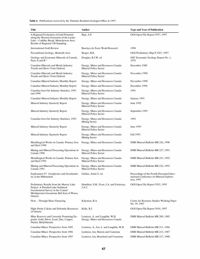
47
Table 6. Publications received by the Timmins Resident Geologist Office in 1997.
Title Author Type and Year of Publication
A Regional Evaluation of Gold Potentialalong the Western Extension of the LarderLake – Cadillac Break, Matachewan Area:Results of Regional Till Sampling
Bajc, A.F. OGS Open File Report 5957, 1997
International Gold Review Barclays de Zoete Wedd Research 1990
Precambrian Geology, Monteith Area Berger, B.R. OGS Preliminary Map P.3367, 1997
Geology and Economic Minerals of Canada,Parts A and B *
Douglas, R.J.W. ed GSC Economic Geology Report No. 1,1976
Canadian Minerals and Metals Industry:Trends and Short--Term Outlook
Energy, Mines and Resources CanadaMineral Policy Sector
December 1988
Canadian Minerals and Metals Industry:Trends and Short--Term Outlook
Energy, Mines and Resources CanadaMineral Policy Sector
November 1990
Canadian Mineral Industry Monthly Report Energy, Mines and Resources Canada November 1990
Canadian Mineral Industry Monthly Report Energy, Mines and Resources Canada December 1990
Canadian Iron Ore Industry Statistics, 1991and 1990
Energy, Mines and Resources CanadaMineral Policy Sector
1991
Canadian Mineral Industry Monthly Report Energy, Mines and Resources Canada January 1991
Mineral Industry Quarterly Report Energy, Mines and Resources CanadaMineral Policy Sector
June 1992
Mineral Industry Quarterly Report Energy, Mines and Resources CanadaMineral Policy Sector
September 1992
Canadian Iron Ore Industry Statistics, 1992 Energy, Mines and Resources CanadaMining Sector
1992
Mineral Industry Quarterly Report Energy, Mines and Resources CanadaMineral Policy Sector
June 1993
Mineral Industry Quarterly Report Energy, Mines and Resources CanadaMining Sector
Fall 1993
Metallurgical Works in Canada: Primary Ironand Steel 1990
Energy, Mines and Resources Canada EMR Mineral Bulletin MR 226, 1990
Mining and Mineral Processing Operations inCanada 1990
Energy, Mines and Resources CanadaMineral Policy Sector
EMR Mineral Bulletin MR 227, 1991
Metallurgical Works in Canada: Primary Ironand Steel 1992
Energy, Mines and Resources CanadaMineral Policy Sector
EMR Mineral Bulletin MR 231, 1992
Mining and Mineral Processing Operations inCanada 1992
Energy, Mines and Resources CanadaMineral Policy Sector
EMR Mineral Bulletin MR 232, 1993
Exploration 97: Geophysics and Geochemis-try at the Millennium
Gubins, Arnis G. ed. Proceedings of the Fourth Decennial Inter-national Conference on Mineral Explora-tion, 1997
Preliminary Results from the Murray LakeProject: A Detailed Lake SedimentGeochemical Survey in the CentralMichipicoten Greenstone Belt East of Wawa,Ontario
Hamilton, S.M., Fyon, J.A. and Fortescue,J.A.C.
OGS Open File Report 5932, 1995
Flow – Through Share Financing Kalymon, B.A. Centre for Resource Studies Working PaperNo. 39, 1987
High--Purity Calcite and Dolomite Resourcesof Ontario
Kelly, R.I. OGS Open File Report 5954, 1997
Mine Reserves and Currently Promising De-posits: Gold, Silver, Lead, Zinc, Copper,Nickel, Molybdenum
Lemieux, A. and Laughlin, W.H.Energy, Mines and Resources Canada
EMR Mineral Bulletin MR 209, 1985
Canadian Mines: Perspective from 1985 Lemieux, A., Jen, L. and Laughlin, W.H. EMR Mineral Bulletin MR 211, 1986
Canadian Mines: Perspective from 1986 Lemieux, Jen, Marois and Cranstone EMR Mineral Bulletin MR 215, 1987
Canadian Mines: Perspective from 1987 Lemieux, Jen, Bouchard and Cranstone EMR Mineral Bulletin MR 217, 1988

48
Table 6. cont’d. Publications received by the Timmins Resident Geologist Office in 1997.
Title Author Type and Year of Publication
Canadian Mines: PerspectiveProduction, Reserves, Development, Explo-ration 1991
Lemieux, Jen, Cranstone and Bouchard NRC MR 233, 1993
Mineral Exploration and Mine DevelopmentPotential in Ontario: Economic Guidelinesfor Government Policy
Mackenzie, B., Bilodeau, M. and Doggett,M.
Centre for Resources Studies, TechnicalPaper No. 9, 1989
Ice Flow Indicators in the Timmins and Kirk-land Lake Area, Northeastern Ontario
McClenaghan, M.B., Veillette, J.J. and Di-labio, R.N.W.
GSC Open File 3014 (map), 1995
Landforms and Surface Materials of Canada:A Stereoscopic Airphoto Atlas and Glossary*
Mollard, J.D. Circa 1979
Results of Modern Alluvium Sampling forKimberlite Indicator Minerals, KinniwabiLake Area, Northeastern Ontario
Morris, T.F., Crabtree, D. and Pianosi, S. OGS Open File Report 5956, 1997
Prospector’s Guide to Drift Prospecting forDiamonds
Morris, T.F. and Kaszycki, C.A. OGS Miscellaneous Paper 167, 1997
Metallurgical Works in Canada: Primary Ironand Steel 1993
Natural Resources Canada, Mining Sector NRC Mineral Bulletin MR 234, 1993
Mining and Mineral Processing Operations inCanada 1993
Natural Resources Canada, Mining Sector NRC Mineral Bulletin MR 235, 1994
Report of Activities 1996, Resident Geolo-gists
Newsome, J.W. and Laderoute, D. OGS Open File Report 5958, 1997
Ontario Airborne Magnetic and Electromag-netic Surveys; Processed Data and DerivedProducts:Black River – Matheson Area
Ontario Geological Survey OGS ERLIS Data Set 1001
Ontario Airborne Magnetic and Electromag-netic Surveys; Processed Data and DerivedProducts: Timmins Area
Ontario Geological Survey OGS ERLIS Data Set 1004
Ontario Airborne Magnetic and Electromag-netic Surveys; Processed Data and DerivedProducts:North Swayze – Montcalm Area
Ontario Geological Survey OGS ERLIS Data Set 1005
Precambrian Geology, Greenwater LakeArea, West--Central Shebandowan Green-stone Belt
Osmani, I.A. OGS Report 296, 1997
Surficial Mapping, Quaternary StratigraphicStudies, and Drift Prospecting in the westernAbitibi Greenstone Belt, Timmins
Paulen, R.C. and McClenaghan, M.B. GSC/NRC/NODA poster, 1997
Geology of the Aquarius Mine, Night HawkLake Area, Timmins, Ontario *
Reddick, J.R. Queen’s University M.Sc. Thesis, 1996
Symposium: Applications of Automation inMining Present and Future
Resource Technology Centre Sudbury, October 1986
Potential Use of Granite Curb for HighwayConstruction in Ontario
Rogers, C.A. Ontario Min. of Transportation and Com-munication Materials Information ReportNo. 86, 1985
Nickel – Copper – Sulphide Mineralization inLabrador: The Voisey Bay Discovery and itsExploration Implications
Ryan, Wardle, Gower and Nunn Newfoundland Dept. of Natural ResourcesReport 95--1, Current Research, 1995
The Structure, Stratigraphy and Mineral De-posits of the Wawa Area
Sage, R.P. and Heather, K.B, GAC/MAC/SEG Field Trip A6: Guide-book, 1991
Industrial Minerals Resources Assessment ofMine Development Rock, Timmins, Ont.
Staff of the Sedimentary Geoscience Sec-tion and Golder Associates
OGS Mineral Deposits Circular 34, 1997
Geological Evolution of North America * Stearn, C.W., Carroll, R.L. and Clark, T.H. John Wiley & Sons, 1979

49
Table 6. cont’d. Publications received by the Timmins Resident Geologist Office in 1997.
Title Author Type and Year of Publication
Introduction to Geology: Physical and His-torical *
Stokes, W.L., Judson, S. and Picard, M.D. Prentice--Hall, 1978
Five--Year Growth Response in Drained andFertilized Black Spruce Peatlands
Sundstrom, E. and Jeglum, J.K. Forestry Canada and MNR NEST Techni-cal Report TR--03, 1992
Applied Geophysics * Telford, Geldart, Sheriff and Keys Press Syndicate, 1976
Gold and the Metals Marketplace The Financial Post Conferences Toronto, October 1990
Sequence of Glacial Ice Flows in Abitibi –Timiskaming
Veillette, J.J. and McClenaghan, M.B. GSC Open File 3033 (map), 1996
Geology of the Manitouwadge – HornepayneRegion, Ontario
Williams, H.R. and Breaks, F.W. OGS Open File Report 5953, 1997
* Donation
Table 7. Mineral deposits not being mined in the Timmins Resident Geologist District in 1997.
Abbreviations
AF Assessment Files MR Mining Recorder
AR Company Annual Report NM The Northern Miner
CMH Canadian Mines Handbook OFR Open File Report
MDC Mineral Deposit Circular PC Personal Communication
MDIR Mineral Deposit Inventory Record RGF Resident Geologist Files
Deposit Name/Township
Commodity Tonnage--GradeEstimates and/orDimensions
Ownership ReservesReference
Status
AllerstonWhitney Township
Talc 36.8 million tonnes (est.) Cominco Ltd. Study 28MDIR C0383
Inactive
AquariusMacklem Township
Au 1997: reserves 1 277 000oz. Au in 19.7 MtIn production 1984,1988--89 produced 27 117oz. @ .19 opT.
Echo Bay Mines Ltd. MDIR C0376PC 1997
ActiveProduction decisiondeferred. Freeze wallconstruction under-way
AugdomeTisdale Township
Au 140 000 T @ 0.10 opTAccessible from DomeMine underground work-ings
Augdome Corporation MDIR C0276 Inactive
Bell Creek Mine (pastproducer)Hoyle Township
Au 61 000 tonnes @ 8.3 g/tIn production 1987--1994,produced 660 827 oz @0.20 opt
Kinross Gold Corporation AR 1996 Care and mainte-nance
Broulan BelmoralWhitney Township
Au 336 000 T @ 0.043 opTIn production 1939--1953,produced 243 757 oz. @0.21 opT.
Royal Oak Mines Ltd. MDIR C0295 InactiveU/G development in1988
Canadian MagnesiteDeloro Township
Magnesite,Talc
100 MT @ 50% magnesiteBulk Sample 1990
Magnesium Refactories MDIR C0007 Inactive
Cargill DepositCargill Township
Phosphate,Vermiculite
18 MT @ 29% P2O5 Agrium Inc. MDIR C0056PC
Active. Expectedproduction to beginmid--1999
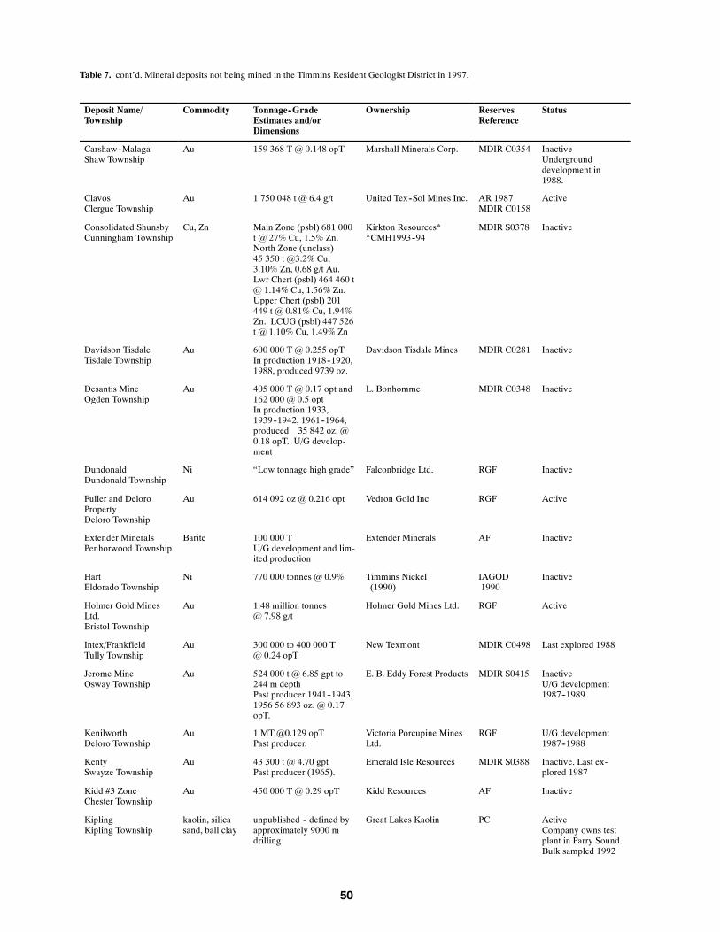
50
Table 7. cont’d. Mineral deposits not being mined in the Timmins Resident Geologist District in 1997.
Deposit Name/Township
Commodity Tonnage--GradeEstimates and/orDimensions
Ownership ReservesReference
Status
Carshaw--MalagaShaw Township
Au 159 368 T @ 0.148 opT Marshall Minerals Corp. MDIR C0354 InactiveUndergrounddevelopment in1988.
ClavosClergue Township
Au 1 750 048 t @ 6.4 g/t United Tex--Sol Mines Inc. AR 1987MDIR C0158
Active
Consolidated ShunsbyCunningham Township
Cu, Zn Main Zone (psbl) 681 000t @ 27% Cu, 1.5% Zn.North Zone (unclass)45 350 t @3.2% Cu,3.10% Zn, 0.68 g/t Au.Lwr Chert (psbl) 464 460 t@ 1.14% Cu, 1.56% Zn.Upper Chert (psbl) 201449 t @ 0.81% Cu, 1.94%Zn. LCUG (psbl) 447 526t @ 1.10% Cu, 1.49% Zn
Kirkton Resources**CMH1993--94
MDIR S0378 Inactive
Davidson TisdaleTisdale Township
Au 600 000 T @ 0.255 opTIn production 1918--1920,1988, produced 9739 oz.
Davidson Tisdale Mines MDIR C0281 Inactive
Desantis MineOgden Township
Au 405 000 T @ 0.17 opt and162 000 @ 0.5 optIn production 1933,1939--1942, 1961--1964,produced 35 842 oz. @0.18 opT. U/G develop-ment
L. Bonhomme MDIR C0348 Inactive
DundonaldDundonald Township
Ni “Low tonnage high grade” Falconbridge Ltd. RGF Inactive
Fuller and DeloroPropertyDeloro Township
Au 614 092 oz @ 0.216 opt Vedron Gold Inc RGF Active
Extender MineralsPenhorwood Township
Barite 100 000 TU/G development and lim-ited production
Extender Minerals AF Inactive
HartEldorado Township
Ni 770 000 tonnes @ 0.9% Timmins Nickel(1990)
IAGOD1990
Inactive
Holmer Gold MinesLtd.Bristol Township
Au 1.48 million tonnes@ 7.98 g/t
Holmer Gold Mines Ltd. RGF Active
Intex/FrankfieldTully Township
Au 300 000 to 400 000 T@ 0.24 opT
New Texmont MDIR C0498 Last explored 1988
Jerome MineOsway Township
Au 524 000 t @ 6.85 gpt to244 m depthPast producer 1941--1943,1956 56 893 oz. @ 0.17opT.
E. B. Eddy Forest Products MDIR S0415 InactiveU/G development1987--1989
KenilworthDeloro Township
Au 1 MT @0.129 opTPast producer.
Victoria Porcupine MinesLtd.
RGF U/G development1987--1988
KentySwayze Township
Au 43 300 t @ 4.70 gptPast producer (1965).
Emerald Isle Resources MDIR S0388 Inactive. Last ex-plored 1987
Kidd #3 ZoneChester Township
Au 450 000 T @ 0.29 opT Kidd Resources AF Inactive
KiplingKipling Township
kaolin, silicasand, ball clay
unpublished -- defined byapproximately 9000 mdrilling
Great Lakes Kaolin PC ActiveCompany owns testplant in Parry Sound.Bulk sampled 1992
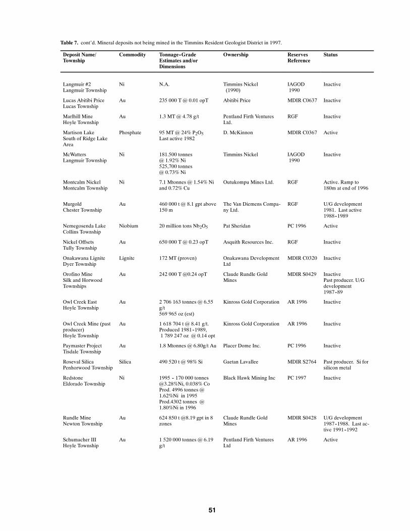
51
Table 7. cont’d. Mineral deposits not being mined in the Timmins Resident Geologist District in 1997.
Deposit Name/Township
Commodity Tonnage--GradeEstimates and/orDimensions
Ownership ReservesReference
Status
Langmuir #2Langmuir Township
Ni N.A. Timmins Nickel(1990)
IAGOD1990
Inactive
Lucas Abitibi PriceLucas Township
Au 235 000 T @ 0.01 opT Abitibi Price MDIR C0637 Inactive
Marlhill MineHoyle Township
Au 1.3 MT @ 4.78 g/t Pentland Firth VenturesLtd.
RGF Inactive
Martison LakeSouth of Ridge LakeArea
Phosphate 95 MT @ 24% P2O5Last active 1982
D. McKinnon MDIR C0367 Active
McWattersLangmuir Township
Ni 181.500 tonnes@ 1.92% Ni525,700 tonnes@ 0.73% Ni
Timmins Nickel IAGOD1990
Inactive
Montcalm NickelMontcalm Township
Ni 7.1 Mtonnes @ 1.54% Niand 0.72% Cu
Outukompu Mines Ltd. RGF Active. Ramp to180m at end of 1996
MurgoldChester Township
Au 460 000 t @ 8.1 gpt above150 m
The Van Diemens Compa-ny Ltd.
RGF U/G development1981. Last active1988--1989
Nemegosenda LakeCollins Township
Niobium 20 million tons Nb2O5 Pat Sheridan PC 1996 Active
Nickel OffsetsTully Township
Au 650 000 T @ 0.23 opT Asquith Resources Inc. RGF Inactive
Onakawana LigniteDyer Township
Lignite 172 MT (proven) Onakawana DevelopmentLtd
MDIR C0320 Inactive
Orofino MineSilk and HorwoodTownships
Au 242 000 T @0.24 opT Claude Rundle GoldMines
MDIR S0429 InactivePast producer. U/Gdevelopment1987--89
Owl Creek EastHoyle Township
Au 2 706 163 tonnes @ 6.55g/t569 965 oz (est)
Kinross Gold Corporation AR 1996 Inactive
Owl Creek Mine (pastproducer)Hoyle Township
Au 1 618 704 t @ 8.41 g/t.Produced 1981--1989,1 789 247 oz @ 0.14 opt
Kinross Gold Corporation AR 1996 Inactive
Paymaster ProjectTisdale Township
Au 1.8 Mtonnes @ 6.80g/t Au Placer Dome Inc. PC 1996 Inactive
Roseval SilicaPenhorwood Township
Silica 490 520 t @ 98% Si Gaetan Lavallee MDIR S2764 Past producer. Si forsilicon metal
RedstoneEldorado Township
Ni 1995 -- 170 000 [email protected]%Ni, 0.038% CoProd. 4996 tonnes @1.62%Ni in 1995Prod.4302 tonnes @1.80%Ni in 1996
Black Hawk Mining Inc PC 1997 Inactive
Rundle MineNewton Township
Au 624 850 t @8.19 gpt in 8zones
Claude Rundle GoldMines
MDIR S0428 U/G development1987--1988. Last ac-tive 1991--1992
Schumacher IIIHoyle Township
Au 1 520 000 tonnes @ 6.19g/t
Pentland Firth VenturesLtd
AR 1996 Active

52
Table 7. cont’d. Mineral deposits not being mined in the Timmins Resident Geologist District in 1997.
Deposit Name/Township
Commodity Tonnage--GradeEstimates and/orDimensions
Ownership ReservesReference
Status
SothmanSothman Township
Ni 231 000 @ 1.3% Ni440 000 @ 0.9% Ni
Falconbridge Ltd IAGOD1990
Thorne Property --Kapika Gold and Gold-en River East ZonesBristol Township
Au 479 180 oz Band--Ore Resources Ltd. RGF Active
WetmoreHoyle Township
Au 290 500 t @ 2.75 gpt inthe North Vein Zone
Pentland Firth VenturesLtd.
MDIR Active
Young ShannonChester Township
Au 695 787 tons @ 3.44 optonAu
Young Shannon GoldMines Ltd.
PC Active

53
Erratum 1
Open File Report 5972
Report of Activities 1997,
Timmins Resident Geologist’s District—Timmins AreaPlease note the addition of the following information for Table 4. p. 35 to 37.
Table 4. Exploration activity in the Timmins District in 1997.
No Company / Individual(Occurrence Name
or Property )
Township / Area(Commodity)
Exploration Activi-ty
8 Band--Ore Resources Ltd. Thornloe, Bristol (Au) IP, GM,DD(186)--50738m
20 Cross Lake Minerals Ltd. / Golden Sheraton, Bond (Zn, Cu, Au) DD, IP, GM, HLEM,
Knight Resources Inc. / East West Assays
Resource Corp. / Canadian Golden
Dragon Resources Ltd.
(Nighthawk Joint Venture)
32a Holmer Gold Mines Ltd. Bristol (Au) DD
37a International PBX Ventures Ltd. McArthur (Au) Lc, IP
72a St Andrew Goldfields Ltd. Stock, Bond (Au) DD, AEM, AM
Table 7, p. 50 and 52 should be modified as follows:
Table 7. Mineral deposits not being mined in the Timmins Resident Geologist District in 1997.
Deposit Name / Commodity Tonnage--Grade Ownership Reserves Status
Township Estimates and/or References
ConsolidatedShunsby
Cu, Zn Main Zone (psbl) 681 000 t Kirkton Resources* MDIRS0378
Inactive
CunninghamTownship
@ 2.7% Cu, 1.5%Zn. NorthZone (unclass) 45 [email protected]% Cu, #.10% Zn, 0.68G/t Au. Lwr Chert (psbl)464 460 t @ 1.14% Cu1.56% Zn. Upper Chert(psbl) 201 449 T @ 0.81%Cu, 1.94% Zn. LCUG(psbl) 447 526 t @ 1.1%Cu, 1.49% Zn
*CMH1993--94
Young ShannonChester Township
Au 695 787 tons @ 0.344 opt Au Young ShannonMines Ltd.
PC Active

54
Erratum 2
Open File Report 5972
Report of Activities 1997,
Timmins Resident Geologist’s District—Timmins AreaPlease note the following changes:
Page 2, last sentence reads:
Claim recordings reached a level not seen since 1965 and the Texasgulf (Kidd Creek Mine) discov-ery.
should read:
Claim recordings declined by 11% from the previous year.
Table 1, page 2 should be changed as follows:
Table 1. Summary of claims recorded and assessment work credit in the Timmins District in 1997
Year ClaimsUnits
Recorded
ClaimUnits
Cancelled
ClaimsUnitsActive
DiamondDrilling
$
PhysicalWork$
GeotechnicalWork$
Total$
1997 45 173 16 908 70 004 N/A* N/A* N/A* N/A*
should read:
Table 1. Summary of claims recorded and assessment work credit in the Timmins District in 1997
Year ClaimsUnits
Recorded
ClaimUnits
Cancelled
ClaimsUnitsActive
DiamondDrilling
$
PhysicalWork$
GeotechnicalWork$
Total$
1997 10 771 16 908 45 173 N/A* N/A* N/A* N/A*

Ontario Geological SurveyResident Geologist Program – 1997
Regional Resident Geologist’s District
Wawa Area
by
A. C. Wilson, M. H. Hailstone and P. M. Morra
1998

56
Wawa Area, Timmins Regional Resident Geologist’sDistrict – 1997
A. C. Wilson1, M. H. Hailstone2 and P. M. Morra3
1District Geologist, Timmins District, Resident Geologist Program
2District Geologist, Sault Ste. Marie District, Resident Geologist Program
3Geological Assistant, Sault Ste. Marie District, Resident Geologist Program
Introduction
Iron mining began its one hundredth year of continuous production from the Helen Iron Range atthe G. W. Macleod Mine in 1997. River Gold Mines Ltd. operated both the Eagle River Mine in theMishibishu Lake area and began trucking and milling ore from the Edwards Project in Finan Town-ship. Gold had last been produced from the Edwards in 1938.
Two advanced exploration projects, both in the Goudreau area, successfully improved the avail-able ore reserves at the Magino Mine and the Island Gold Project (Lochalsh Deposit).
Announcements concerning a new discovery of diamonds in Lalibert and Menzies townships bySpider Resources Inc. — KWG Resources Inc., and the discovery of significant haloes of kimberliteindicator minerals in the Whitefish Lake area by Canabrava Diamond Corporation sparked a stakingrush in the Wawa area in mid--summer.
Mid--summer also saw the completion of an agreement between Algoma Central Corporation(ACC) and McDonald Investment Company Inc. of Birmingham, Alabama on the sale of 816 000acres of ACC’s land holdings north of Sault Ste. Marie.
Seventeen active exploration projects were ongoing in the Wawa area during the year. The Ontar-io Prospectors Assistance Program (OPAP) provided funding of $60 000 for 5 designated projects inthe area.
A summary of the claims recorded and assessment work credit filed in the former Sault Ste. MarieMining Division is presented in Hailstone and Morra (this volume). Hailstone and Morra (this vol-ume) also provide information for the Wawa area on the assessment files received in Sault Ste. Marieand on Wawa specific publications received in Sault Ste. Marie.

57
Mining Activity
Total production and reserve figures for the 3 mines operating in the Wawa district is summarizedin Table 1. Total historical production of gold for the Michipicoten greenstone belt is presented inTable 1b. The locations of each of the producing mines are presented on Figure 1.
ALGOMA ORE DIVISION – G. W. MACLEOD MINE
The G. W. Macleod Mine produced 645 514 tons of natural siderite ore during 1997 (A. L. Ste-vens, Algoma Ore Division, personal communication, 1998). Production statistics and raw materialconsumption for the year are presented below:
Total Sinter Production 782 662 tons
Superfluxed Sinter 621 361 tons
Low Flux Sinter 155 422 tons
Total Sinter Shipped 776 783 tons
Sinter on Wawa Stockpile (31/12/97) 137 505 tons
Raw materials used for total sinter production include:
Siderite Natural Ore 645 514 tons
Limestone 162 931 tons
Reverts/Oxides 339 419 tons
Subgrade Fines 23 433 tons
The mine is expected to produce approximately 500 000 tons of superfluxed sinter, in 1998, to beshipped to the Algoma Steel Inc. steelworks in Sault Ste. Marie.
On December 2, 1997, Algoma Steel Inc. announced that the G. W. MacLeod Mine would closein mid--1998. The reason for the closure is reported to be the inability of the mine to effectively com-pete with other alternate sources of supply. All of the approximately 200 permanent employees at themine will be provided with positions at the Corporation’s facilities in Sault Ste. Marie. Algoma Steelwill be working with the community of Wawa, as well as the provincial and federal governments, inorder to determine ways in which the community can be assisted with the impact of the closure (Algo-ma Steel Inc., press release, December 2, 1997).

58
Figure1.WawaDistrict,exploration,developm
entand
miningactivity,1997.

59
Table 1. Mine production and reserves in the Wawa Area.
Mine Production to end of 1996 Production in 1997 Reserves at end of 1997
Tonnage @Grade
TotalCommodity
Tonnage @Grade
TotalCommodity
Tonnage Grade
Algoma OreDivision,G. W. MacleodMine
739 569 tons@ 31.5% Fe
832 544 tonssinter
645 514 tons@ 34.8% Fe
782 662 tonssinter
17 456 000 tons 31.0% Fe
River Gold MinesLtd.,Eagle River Mine
162 074tonnes @12.76 g/t
64 523 oz Au 156 293@ 9.2 g/t
46 312 oz Au 1 158 000 tonnes 10.97 g/t
River Gold MinesLtd.,Edwards Project
1573 tons@ 3.0 oz/t*
485 oz Au* 62 963tonnes @15.23 g/t
30 414 oz Au 28 835tonnes (proven)127 214 (probable)
12.09 g/t
*Edwards Property last produced ore in 1938
RIVER GOLD MINES LTD. – EAGLE RIVER MINE
The Eagle River Mine is a classic, shear--hosted, narrow quartz vein, high--grade gold deposit. Itis situated within the Eagle River Deformation Zone (ERDZ) of the Mishibishu Lake greenstone belt.Numerous mineralized zones have been identified along the 14--kilometre strike length of the ERDZon the Eagle River property. Production and development work in 1997 concentrated on the No. 8and the No. 6 Zones. Both of these zones are hosted by shears, which cut a quartz diorite stock. Theore zones dip vertically, are moderately to steeply dipping to the east and have mineable widths of be-tween 1.5 and 7.5 metres (River Gold Mines Ltd., 1996 Annual Report). Production and reserve fig-ures for the mine are presented in Table 1.
In late 1996, the company began work on a $10 million shaft sinking and exploration program tobe completed by 1998. The shaft will eventually reach 700 metres and it will provide access to thedepth extensions of the known ore zones. Delineation drilling of the No. 6 Zone was completed dur-ing the year and early results show continuity of the mineralization at a vertical depth of 400 metres.Underground exploration of the No. 7 Zone resulted in the extension of this high--grade zone to adepth of 100 metres. The No. 7 zone parallels the current mine workings. A surface diamond--dril-ling program also investigated the depth extensions of the Papa and HP zones. The company contin-ues to prospect to the east of the minesite (Eagle River Gold Mines Ltd., press release, July 31, 1997).
Five kilometres east of the Eagle River property, surface prospecting by the company identified anew structure, the Iron Hat Vein. Grab samples from the vein returned assay values up to 150 g/tgold. Several veins in this vicinity merit future diamond drilling (Eagle River Gold Mines Ltd, pressrelease, November 6, 1997).
The mine is accessed by a decline ramp. Shrinkage stope mining of the No. 6 and No. 8 Zoneshas taken place above a depth of 220 metres. The company operates 550--tpd mill on the site of theformer Magnacon Mine.
A combined total of 172 people are employed by the company at the Eagle River Mine and theEdwards Project.
RIVER GOLD MINES LTD. – EDWARDS PROJECT
In early 1996 River Gold Mines Ltd. entered into a ten--year agreement with VenCan Gold Corpo-ration to develop and mine the former Edwards Gold Mine in Jacobson Township. The property liesapproximately 100 km northeast of the Eagle River Gold Mine. Development and mining of ore be-

60
gan early in 1997, with the ore being trucked to the Eagle River mill at a rate of approximately 500tpd. Milling of the Edwards ore was delayed for two months because of the need to construct an ac-cess road to the Magnacon mill. In addition, River Gold decided to concentrate all of the 1997 pro-duction from the Edwards into a single mill run of approximately 45 000 – 50 000 tons (The NorthernMiner, September 1, 1997, p.3).
Bruce (1940) originally described the geology at the Edwards. According to Bruce, the 2.5--footwide vein reportedly cut a porphyry dike and metavolcanic rocks. The vein strikes 293_ and dips 75_to the north. Mineralization is concentrated in two, high--grade, gold--bearing zones: the Porphyry andthe Carbonate zones. Two additional untested targets, the Shaynee and the New North horizons, lie tothe east and west of the main mineralized zones (Wilson 1992).
Development at the mine consisted of completion of the decline ramp to the 380--vertical--footlevel and stope development from the 200--foot level up to near surface for both of the high--gradezones. The original mineral inventory, prepared by VanCan, for the two zones was listed as a drill--in-dicated reserve (probable) of 43 915 tons grading 0.964 ounces of gold per ton (uncut) within 200 feetof surface (The Northern Miner, September 1, 1997, p.1).
Table 1a: Gold Production from the Wawa Area to the end of 1997
Mine Name Township In Production Tons Milled Oz. Au Grade
Alden--Goudreau Cowie 1937, 40, 43, 45 13 479 3220 4.2
Centennial Naveau 1939--40 8612 610 14.1
Cline Jacobson 1938--40, 1947--48 331 842 63 328 5.2
Darwin/Grace McMurray 1902--03, 07--08,10, 23, 25, 30, 35,37, 40, 43--44
45 528 15 191 3.0
Deep Lake McMurray 1936--1938, 1943 2790 1633 1.7
Eagle River Point Isacor 1995-- 318 367 110 835 10.98 g/t
Edwards Jacobson 1938 1537 485 3.2
1997 62 963 30 414 15.23 g/t
Holdsworth Prospect Corbiere 1933 60 10 6
Kremzar Finan 1989--90 392 858 37 678 4.5g/t
Magino/Algoma Summit Finan 1930--40, 1988--92 768 679 + 113 228 4.5 g/t
Magnacon Mishbishu Lake 1989--90 165 000 15 356 10.7
Minto (includes Jubileeand Cooper)
McMurray 1929--1942 184 600 37 678 4.9
Murphy/Algold/Amherst
Abotossaway 1926--32, 36--38,1940
23 211 2450 9.5
Norwalk/Manxman Naveau 1904, 1910 820 60 13
Parkhill McMurray 1902, 29, 30--38,40--44
125 778 54 301 2.3
Ranson Rabazo 1939 774 156 4.96
Renabie Leeson 1947--70, 1981--91 5 583 895 1 100 000 0.2
Smith/Van Sickle McMurray 1935--36 9228 536 17.2
Surluga McMurray 1968--69, 1988--89 87460 8898 n.a.
Stanley McMurray 1936 1963 84 23.3

61
Table 2. Exploration activity in the Wawa Area in 1997.
Abbreviations
AEM Airborne electromagnetic survey GM Ground magnetic survey
AM Airborne magnetic survey HLEM Horizontal loop electromagnetic survey
Beep Beep Mat survey IP Induced polarization survey
DD Diamond drilling Lc Linecutting
DDH Diamond drill hole(s) Pr Prospecting
GC Geochemical survey Samp Sampling (other than bulk)
GEM Ground electromagnetic survey Str Stripping
GL Geological Survey Tr Trenching
No Company/Individual(Occurrence Name)
or Property
Township/Area(Commodity) Exploration Activity
1 Atkins, W. M. Abbie Lake (Au) Str, Tr, Samp, Pr
2 Canabrava Diamond Corporation(Whitefish Lake Diamond Project)
Maness, Fiddler, Cowie, Issac, Michanoand Miskokomon (diamonds)
Samp, AEM, AM, GL, GC,
3 Fraser, M. Stover (Au) Str, Tr, Samp, Beep, Pr
4 Golden Goose Resources Ltd.(Magino Mine)
Finan (Au) DD, Str, Tr, Samp, GL, GC
5 Hutteri, H. Chabanel (Au) Str, Samp, GL, GEM, GM
6 Luciuk, G. Stover (Au) Str, Tr, Samp, GL, GC
7 Mealey, G. L. and Mealey, W. B. Abraham (Au) Str, Tr, Samp, Pr, GEM, GM
8 Mishibishu Gold Corporation(Mishi Gold Project)
Mishibishu Lake and David Lake (Au) Str, Tr, Samp, Lc, GC, GL
9 Murgor Resources Inc.(Mishibishu Lake Project)
Mishibishu Lake (Au) Lc, GM, HLEM, Samp Str, Tr, GL, GC
10 Nicholson,T. Gratton, G. Riggs (Au) Pr, Samp
11 Noront Resources Ltd. Meath and Rennie (Au) GL, GEM, GM
12 O’Reilly, G. and Gerdes, J. Dolson and Echum (diamonds) Pr, Samp
13 Patricia Mines Inc.(Island Lake Project)
Finan (Au) DDH (34), Str, Tr, Samp, GL, GC
14 Pele Mountain Resources Inc.(Markes Gold Prospect)
Jacobson (Au) DDH (30), Samp, GL
15 Prime Equities InternationalCorporation (Otter Pond Occurrence)
Corbiere Tp (Au) Str, Tr, Samp, GL, GC
16 River Gold Mines Ltd (Eagle RiverGold Mine)
Point Isacor (Au) Pr, Str, Tr, Samp
17 Spider Resources Inc. and KWGResources Inc.
Lalibert and Menzies (diamonds) Str, Samp, AEM, AM, GL, GC

62
Advanced Exploration
The location of advanced exploration projects is shown on Figure 1.
GOLDEN GOOSE RESOURCES INC. – MAGINO GOLD MINE
Golden Goose Resources Inc. holds a 100% interest in the former Muscocho Explorations Limited— McNellen Resources Inc. owned Magino Gold Mine in Finan Township. Magino operated from1988--1992 when the mine closed due to low gold prices. At the time of shutdown, Magino had pro-duced 102 185 ounces of gold and contained a resource of 611 000 tonnes grading 5.6 g/t gold (Wil-son 1992). The Magino Mine was previously operated as a narrow--vein, underground mining opera-tion, however the company is now examining the potential of operating a large tonnage open pit at thesite.
A 10--hole (2088 m) surface diamond drilling program tested three profiles through the deposit.These profiles were drilled to depths of 100 to 250 metres in the west, main and northeast areas of themine property. The mineralized profiles were 9.5 to 48 metres long, with gold grades ranging from 1to 4 g/t gold (The Northern Miner, August 4, 1997, p.4). A new resource estimate was calculated us-ing the results from the 1997 drilling program. One calculation, the inverse--distance--squared meth-od, using a cutoff grade of 0.86 g/t gold resulted in a resource of 24 million tonnes grading 1.68 g/tgold or 1.3 million ounces. The second calculation, using the Kriging method, returned a resource of35.7 million tonnes @ 1.16 g/t gold or 1.3 million ounces (The Northern Miner, August 11, 1997,p.15).
PATRICIA MINES INC. – ISLAND GOLD PROJECT
An extensive program of infill diamond drilling and bedrock stripping/trenching was conductedby Patricia Mines Inc. to assess the mineral resource of the Lochalsh Deposit (Island Gold Project) inFinan Township. As a result of the diamond drill program, the company was able to extend theknown depth of mineralization in the Lochalsh Deposit by 100--300 metres along its 1 km strikelength (The Northern Miner, October 27, 1997, p.18). In 1990, a 1 km long decline ramp was driv-en into the Island Zone by Canamax Resources Inc. and a bulk sample was extracted from the 125--and 140--metre levels. The 4172--tonne sample had a head grade of 6.6 g/t gold (Tortosa et al. 1990).
An independent resource evaluation of the deposit by Roscoe Postle and Associates Inc. was re-leased in early 1998. Roscoe Postle estimates the Island/Lochalsh Deposit contains a total resource of883 000 tonnes grading 6.50 g/t gold, for a total of 184 608 ounces of gold in all categories (PatriciaMines Ltd., press release, January, 15, 1998). This reserve calculation is based upon 96 surface and50 underground diamond drill holes (37 019 m total) spaced at approximately 25 m over the 1 kmstrike length of the deposit, to a maximum depth of 320 metres.
Surface trenching was also conducted on a number of other high--grade gold occurrences on theproperty. Notable assays include: average values of 20.94 g/t gold across a width of 1.7 m from theNo. 2 Zone; average values of 2.82 g/t gold over a combined width of 15 m from the Morrison Zone;40.60 g/t gold over a width of 2.6 m from the No. 9 Zone; and a grab sample of 58.80 g/t gold from avein at the Tent Zone (Patricia Mines Inc., press release, October 8, 1997).
Company land holdings also include the former Kremzar Mine and mill, operated by Canamax inthe late 1980’s. During its two years of operation, the Kremzar produced 46 000 ounces of gold at ahead grade of 4.7 g/t Au. The deposit was mined to a depth of 240 metres and still contains an esti-mated reserve of 350 000 tonnes grading 6.3 g/t Au (The Northern Miner, July 28, 1997).

63
Exploration Activity
Locations of exploration activity are shown on Figure 1 and Table 2.
CANABRAVA DIAMOND CORPORATION
Approximately 75 000 hectares of ground was acquired by Canabrave Diamond Corporation fromAlgoma Central Corporation following the release of a stream sediment survey for kimberlite indica-tor minerals by the Ontario Geological Survey (OGS). The results of the OGS survey indicated thepresence of G--10 garnets and high--chromium chromites and the report suggested that the source forthese indicator minerals was local. This property, known as the Whitefish Lake property, is located 30km northeast of Wawa.
Following the completion of a high--resolution aeromagnetic survey and an intensive till, streamand lake bottom sediment survey, the company announced the discovery of a kimberlite pipe cluster,as well as, 3 new kimberlite indicator mineral haloes on their Whitefish Lake property (CanabravaDiamond Corporation, press releases, September 17, 1997 and December 9, 1997). Fresh olivine,pyrope garnet and picroilmenite were discovered within the indicator haloes. The presence of fresholivine suggests a local kimberlitic source for the minerals. Microprobe analysis of the grains will becompleted in early 1998. A ground follow--up survey of the kimberlite pipes is expected in the com-ing year.
MISHIBISHU GOLD CORPORATION
Mishibishu Gold Corporation purchased a 100% interest in the Mishi Gold project from MacMil-lan Gold Corp. The Mishi Gold project is located within the Mishibishu Lake Deformation Zone(MLDZ) in the Mishibishu Lake area. The Mishi Main Zone has been estimated to contain a mineralresource of 1 424 300 tonnes grading 4.24 g/t gold. This resource includes an open pittable reserve of772 000 tonnes grading 3.3 g/t gold (Mishibishu Gold Corporation, press release, September 9, 1997).
The company completed geological mapping, channel sampling, soil sampling and mechanicaltrenching on the property. Several anomalous gold zones were discovered along strike to the west ofthe Mishi Main Zone. Selected channel sample values include: 13.25 g/t gold across 3 metres, 10.59g/t gold across 1.2 metres, 9.69 g/t gold across 1.8 m and 5.03 g/t gold across 2.5 meters (MishibishuGold Corporation, press release, November 24, 1997).
MURGOR RESOURCES INC.
Murgor Resources Inc. completed an extensive surface exploration program on their MishibishuLake area property during 1998. Work consisted of a ground geophysical (IP) survey as well as bed-rock stripping and channel sampling. Of note was a discovery on the Dorset Zone. Channel samplesyielded assays of 2.67 g/t Au across 12.5 m, including 4.82 g/t Au across 4.2 m and 3.66 g/t Au over10.6 m, including 6.19 g/t Au across 2.1 m. This zone varies from 2--12 m in width over its 4--kmlong strike length and is hosted by pillowed metavolcanic and clastic metasedimentary rocks (MurgorResources Inc., press release, December 17, 1997).
The property is situated in the Mishibishu Lake area, west of the Mishi Deposit and the past--pro-ducing Magnacon Mine, and north of the Eagle River Mine.
PELE MOUNTAIN RESOURCES INC.
A 30--hole (3000 m) surface diamond drilling program was completed by Pele Mountain Re-sources Inc. on the Markes and Vega gold occurrences in Jacobson Township. Both properties are lo-
64
cated to the east of the past--producing Cline Gold Mine and are hosted by mafic metavolcanic rocksand quartz--phyric or quartz--feldspar porphyry dikes of the eastern Goudreau Lake Deformation Zone.The boundaries of the main mineralized shear zone are defined by narrow, 1--2 cm wide, crack andseal, quartz--tourmaline--bearing shears (Sage and Heather 1991).
PRIME EQUITIES INTERNATIONAL CORPORATION
Prime Equities International Corporation has entered into a Mineral Exploration License Agree-ment with Algoma Central Corporation. The agreement covers 41.5 km2 and includes the Otter PondOccurrence in Corbiere Township. Prime Equities has optioned the Otter Pond Occurrence from SaultSte. Marie prospectors, George Lucuik and Cliff Hicks (Prime Equities International Corporation,press release, February 10 1997). Messrs. Lucuik and Hicks, partially financed with an Ontario Pros-pector’s Assistance Program (OPAP) grant explored the Otter Pond Occurrence in 1996.
Channel sampling was conducted on the property by the company during 1997. Seven samplescut along the exposed dip surfaces of the veins assayed between 6.4 g/t and 74.1 g/t gold. An addi-tional 10 grab samples assayed between 1.2 g/t and 5.5 g/t gold. Prime Equities also completed a soilsample survey and a ground geophysical survey (Prime Equities International Corporation, press re-lease, June 5, 1997).
SPIDER RESOURCES INC. — KWG RESOURCES INC.
A spring and early summer program conducted by Spider Resources Inc. included the collectionand sampling of 367 till samples and 103 rock samples, geological mapping and ground geophysicalsurveys on their property located in Lalibert and Menzies townships. A total of 95 diamonds, includ-ing 15 macrodiamonds, were recovered from a 167.4 kg sample taken from a roadcut on Highway 17.The largest diamond recovered was a white, transparent fragment measuring 0.82 mm by 0.76 mm by0.65 mm (Spider Resources Inc. – KWG Resources Inc., press release, August 19 1997). In a laterpress release, the company announced that a total of 231 diamonds were recovered from 8 separateoutcrop areas during the 1997 sample analysis. Two of these outcrops represent new discoveries (Spi-der Resources Inc. – KWG Resources Inc., press release, November 5, 1997).
The company plans to focus its 1998 exploration program on these 8 outcrop areas. They willconduct a program consisting of bedrock trenching, geological and geophysical surveying and dia-mond drilling.

65
Staff and Activities
As a result of the restucturing of the Resident Geologist’s Program in early 1997, responsibilityfor the Wawa area was shifted to the Timmins Regional Resident Geologist’s Office. Prior tomid--1997, Wawa area clients were served by staff based in Sault Ste. Marie. Service to Wawa areaclients is now provided from both Sault Ste. Marie (M. H. Hailstone) and Timmins (A. C. Wilson).Assessment files and a complete library for the Wawa area are currently available for viewing at theSault Ste. Marie office. In Timmins, assessment files for the Wawa area are available for viewing onthe regional ERLIS system. A complete reference library of OGS material for the Michipicotengreenstone belt will also be available in Timmins in 1998.
A Wawa--specific library of Ontario Geological Survey publications was compiled in Timmins bythe District Geologist and is available for viewing or borrowing from the Wawa Northern Develop-ment Officer’s office. This library consists of all Geological Reports, Open File Reports, airbornegeophysical surveys, preliminary geological maps and final geological maps. A small selection ofgeneral interest Miscellaneous Papers and Mineral Resource Circulars is also available for consulta-tion.

66
Property Examinations
SPIDER RESOURCES INC. – KWG RESOURCES INC.
In early October, a field visit was made to the Spider Resources Inc. – KWG Resources Inc. prop-erty by R. P. Sage (OGS, Sudbury) and A. C. Wilson, District Geologist. The property is located onthe Trans--Canada Highway about 25 km west of Wawa. The purpose of the visit was to examine andsample outcrop exposures where recent diamond discoveries have been made.
Spider Resources Inc. currently holds a five--year exploration licence agreement with AlgomaCentral Properties Inc., which has recently been acquired by New Hampshire based McDonald Forest-ry Products (KWG Resources Inc.– Spider Resources Inc., press release, November 5, 1997). Eventhough the agreement covers an area of 222 km2, exploration is focussed on a 45 km2 area where 8separate outcrops have yielded diamonds. This area includes the site of the 1995 diamond discoverymade by Sandor Surmacz and Marcelle Hauseaux (Bennett, Hailstone and Fremlin 1997).
The property is underlain by the supracrustal rocks of the 2700 Ma cycle of the Michipicotengreenstone belt. These rocks are dominantly intermediate to felsic tuffs and poorly--bedded to massivequartz--feldspar crystal tuffs. Oligomictic and polymictic breccias stratigraphically overlie the tuffsand are sporadically found on the property. Most breccias are oligomictic and consist of either brecciafragments in a matrix of similar composition or fragments within a chlorite--rich matrix. Fragmentsare up to 0.3 m in size (Sage 1993).
Diamonds are hosted within narrow (1--10 m wide), xenolith--rich ultramafic dikes which crosscutthe stratigraphy. These dikes are typically characterized by round to elliptical, actinolite or actinoliteplus talc inclusions which may reach up to 0.5 m in size. The actinolite inclusions frequently consistof large (up to 8 cm), prismatic crystals which may be arranged randomly or radiate inwards towardthe inclusion centre. Actinolite--talc inclusions consist of talc cores surrounded by radiating prismaticor acicular actinolite crystals (Sage 1993). Black, biotite--rich reaction rims are frequently observedenclosing the xenoliths. Sage (1993) suggests that the xenoliths may represent at least two originalmafic compositions. They are likely to be of lower crust, or deeper, origin. Other diamond--bearingdikes in the vicinity are characterized by carbonate--altered ultramafic xenoliths. These dikes are lesscommonly observed.
The matrix of the dikes is variable in appearance. In some cases, the matrix is biotite-- and actino-lite--rich and is dark green in colour. These dikes resemble more conventional ultramafic dikes. Inother instances, the matrix is light grey in colour and it is difficult to distinguish dikes with this matrixfrom the surrounding felsic lapilli tuffs.
Two ages of xenolith--bearing dikes have been observed on the property. The oldest are xenolith--rich dikes containing approximately 50--60% rounded inclusions. Younger, relatively xenolith--freedikes appear to crosscut this series of dikes. These younger dikes contain approximately 20--30% sub-angular to subrounded xenoliths. Both sets of dikes are diamond--bearing. When both phases of thedikes crosscut each other and are hosted by one of the supracrustal breccias, it is simple to distinguishamong the three rock types. Identification is far more difficult when the xenolith--poor dikes appearon their own in outcrop.
The older set of dikes trends northwest to west--northwest and the younger set of dikes trendsroughly west. Because a weakly developed regional schistosity crosses these dikes, it is implied thatthey are Archean in age.
Chemically, it is suggested that these rocks have lamprophyric affinities (KWG Resources Inc.–Spider Resources Inc., press release, November 6, 1997; Sage 1993).

67
Eight separate outcrops on the property have yielded 231 diamonds. Of this number, 37 of thediamonds are greater than 0.5 mm in one dimension and this includes 5 that are greater than 0.8 mmin one dimension (KWG Resources Inc.—Spider Resources Inc., press release, November 5, 1997).
A complete suite of the xenoliths and the host rocks is available for viewing at the Timmins Resi-dent Geologist’s Office in South Porcupine.

68
Recommendations for Exploration
DIAMONDS IN ARCHEAN LAMPROPHYRE DIKES
Known commercial diamond deposits occur only in kimberlite and lamproite, although diamondshave been discovered in a variety of other host rocks. Lamprophyres, specifically monchiquites andaillikites, have been reported as hosting diamonds. Occurrences of diamond--bearing lamprophyreshave been reported in Canada. Sage (1996) has compiled a comprehensive listing of these variousrock types and the reader is referred to his publication and bibliography for further details.
Within the Michipicoten greenstone belt, lamprophyre dikes have been mapped in two broad geo-graphic regions. One area lies between the former Magpie Mine in Leclaire Township and the Dick-enson Lake Stock in Knicely Township and the second lies to the south of the Wawa--Hawk--Manito-wik Lakes Fault system. Lamprophyre dikes in the first area are Archean in age and occur as one ofthree types. They are biotite--rich lamprophyres, lamprophyres with a biotite--actinolite rich matrixand containing rounded xenoliths, and heterolithic breccias similar to diatreme breccias. Lampro-phyre dikes in the second area are Proterozoic in age and are interpreted as being related to the Kapus-kasing Structural Zone (Sage 1994). No lamprophyre dikes have been mapped in the Goudreau area,west of the Dickenson Lake Stock or east of the Magpie Mine.
The 1995 and 1997 discoveries of macrodiamonds in Archean lamprophyric dikes in the Wawaarea suggest that there is potential for similar discoveries not only in the Wawa area, but in othergreenstone belts in the province.
The xenolith--rich dikes in the vicinity of the KWG Resources Inc.--Spider Resources Inc. proper-ty were recognized and reported in 1926 by Collins, Quirke and Thomson. They described the dikesas “spherulitic greenstone” and suggested that the rock could readily pass as a conglomerate. Theirdescription accurately describes both the location and the rock type, although they did not attach anyeconomic significance to their presence. Numerous other older geological publications also make ref-erence to “cobble dikes” or pebble lamprophyres. These could be descriptions of dikes similar to thexenolith--bearing lamprophyre dikes. It is recommended that particular attention be paid to any de-scriptions that might appear in any vintage geological publications of cobble or rubble dikes, pebblelamprophyre, spherulitic greenstones or unusual conglomerates. Every attempt should be made to lo-cate, examine and sample rocks matching these descriptions.

69
Acknowledgements
M. H. Hailstone provided information for Table 2. Figure 1 was prepared by P. M. Morra.

70
References
Bennett, G.,Hailstone,M. andFremlin, B. 1997. Sault Ste.MarieResident Geologist’sDistrict; inReport ofActiv-ities, Resident Geologists; Ontario Geological Survey, Open File Report 5958, p.10--1 to 10--26.
Bruce E. L. 1940. Geology of the Goudreau--Lochalsh Area; Ontario Department of Mines, Annual Report, 1940,v. 49, pt. 3, 50p.
Collins, W. H., Quirke, T. T. and Thomson, E. 1926. Michipicoten Iron Ranges; Geological Survey of Canada,Memoir 147, 175p.
Sage, R. P. 1993. Geology ofKillins, Knicely and Lalibert townships, District of Algoma; Ontario Geological Sur-vey, Open File Report 5589, 141p.
1994. Geology of the Michipicoten Greenstone Belt; Ontario Geological Survey, Open File Report 5888,592p.
1996. Kimberlites of the Lake Timiskaming Structural Zone; Ontario Geological Survey, Open File Report5937, 435p.
Sage, R. P. andHeather, K. B. 1991. The Structure, Stratigraphy andMineral Deposits of theWawa Area: Geologi-cal Association of Canada, Mineralogical Association of Canada, Society of Economic Geologists, JointAnnual Meeting, Toronto ’91, Field Trip A6: Guidebook, 118p.
Tortosa, D. J. J., Frey, E. D., Delisle, P. C., Lowe, C., Wilson, A. C., Beach, P. and Walmsley, J. R. 1991. WawaResident Geologist’s District — 1990; in Report of Activities, Resident Geologists’ Ontario Geological Sur-vey, Miscellaneous Paper 152, p.179--201.
Wilson, A. C. 1992. Wawa Resident Geologist’s District — 1991; in Report of Activities, Resident Geologists;Ontario Geological Survey, Miscellaneous Publication 158, p. 201--214.
1993. WawaResidentGeologist’sDistrict—1992; inReport ofActivities, ResidentGeologists; OntarioGeo-logical Survey, Miscellaneous Publication 161, p. 195--206.

71
Table 3. Mineral deposits not being mined in the Wawa Area in 1997.
Abbreviations
AF Assessment Files MLS Mining Lands, Sudbury
CMH Canadian Mines Handbook MR Mining Recorder
GR Geological Report NM The Northern Miner
MDC Mineral Deposit Circular OFR Open File Report
MDIR Mineral Deposit Inventory record PC Personal Communication
DepositName/NTS
Commodity Tonnage--GradeEstimates and/orDimensions
OwnershipReferences
ReserveReferences
Status
Braminco ProspectBrackin Township
Au 100 000 T @0.15 opT (#21 Vein);23 000 T @ 0.31 opT (#7 Vein);5000 T @ 0.26 opT (B Vein)
Conquest YellowknifeResources Ltd.
RGF Inactive
Conboy LakeProspectRennie Township
Zn 100 000 tons @ 8.3% Zn,5.5 opt Ag; strike length125 m, extends to 140 m,maximum width 1.8 m
N. A. RGF Active exploration1997
Goudreau ZoneFinan Township
Au 198 000 tonnes @ 8.4 g/t Patricia Mines Ltd. Jan. 15, 1998companypress release
Active exploration1997
Kremzar Mine(past producer)Finan Township
Au 298 000 tonnes @ 6.3 g/tPast producer 1988--1990,46 000 oz @ 4.7 g/t
Patricia Mines Ltd. Jan. 15, 1998companypress release
Care andmaintenance
Lochalsh Deposit(Island GoldProject)Finan Township
Au 883 000 tonnes @ 6.5 g/tincludes 148 000 tonnes @5.34 g/t (measured);260 000 tonnes @ 6.95 g/t(indicated); 475 000 tonnes@ 6.61 g/t (inferred)
Patricia Mines Ltd. Jan.15, 1998companypress release
Active. Under-ground ramp to140 m
Magino Mine(past producer)Finan Township
Au 24 million tonnes @ 1.68 g/t. Pastproducer 1988--92, 101 948 oz
Golden GooseResources Inc.
NM, Aug. 111997
Active
Magnacon Mine(past producer)Mishibishu LakeArea
Au 1.47 million tons aver.0.19 oz/t (drill indicated).Past producer 1990, 19 397oz from 163 366 tons
Golden GooseResources Inc
CMH,1997--98,p. 204
Inactive
Mishi Main ZoneMishibishu LakeArea
Au 1 424 3000 tonnes@ 4.24 g/t; open pittablereserve 772 000 tonnes@ 3.3 g/t
Mishibishu Gold Cor-poration
CMH,1997--98,p.318--319
Active exploration1997
Nudulama ProspectLeeson Township
Au 579 325 T @ 0.194 opT Conquest YellowknifeResources Ltd.
RGF Inactive
No. 8 ZoneFinan Township
Au 90 700 tonnes @ 6.9 g/t Patricia Mines Ltd. Jan. 15, 1998companypress release
Exploration 1997
Pine Zone Fi-nan Township
Au 70 000 tonnes @ 6.4 g/t Patricia Mines Ltd. Jan. 15, 1998companypress release
Inactive
Surluga Mine (pastproducer) McMur-ray Township
Au 385 000 tons @ 0.21 opt.Past producer 1989, 4921oz Au & 383 oz Ag
Citadel Gold MinesInc.
NM, March 5,1990
Care andmaintenance

Ontario Geological SurveyResident Geologist Program – 1997
Sault Ste. Marie Resident Geologist’s District
by
M. Hailstone and P. Morra
1998
73
Sault Ste. Marie Resident Geologist District – 1997M. Hailstone1 and P.Morra2
1District Geologist, Sault Ste. Marie, Resident Geologist Program, Ontario Geological Survey
2Geological Assistant, Sault Ste. Marie, Resident Geologist Program Ontario Geological Survey
Introduction
The primary mineral production in the Sault Ste. Marie district is bedrock aggregate from four quar-ries. A total of 5 mineral exploration projects were conducted in the district during the year including 2diamond drill programs for Keweenawan mineralization, 2 prospecting projects for gold and 1 prospect-ing project for copper zinc. Total explortation expenditures amounted to approximately $1.2million. Thisyear 3 OPAP programswere conducted in the Sault Ste. Marie district. Details on exploration activity forthe Sault Ste. Marie district can be found in the text and by reference to Table 3. and Figure 1. This reportcontains details of theWawa district in Table 2. However details on exploration development and miningactivity aswell as property visits and recommendations for exploration in theWawaDistrict, are publishedunder a separate chapter for the Wawa district.
74
Mining Activity
ONTARIO TRAP ROCK ( A DIVISION OF R.W. TOMLINSON LIMITED)
A crushed bedrock aggregate is quarried fromNipissing diabase at theOntarioTrap Rock site near theTown of Bruce Mines. Ontario Trap Rock produces armour stone, railway ballast, products for road sur-facing and material for rock wool insulation.
During 1996 the State of Michigan added 4 cents a gallon to the price of gasoline to finance a majorhighway reconstruction andmaintenance program. The company is aggressively pursuing the sale of theirproducts to Michigan.
The company has increased the number of employees from18 salariedworkers to 40. Expendituresonwages, fuel and materials amount to about $1 million per year.
The operating season begins in March and normally ends in November . Aggregate is shipped bytruck, rail and water. During 1997 there were 22 vessels loaded with a total of 318 000 tons of product atthe company’s ship loading facilities near Bruce Mines. Production figures are shown in Table 2.
Table 1. Mine production and reserves in the Sault Ste Marie District.
Mine Production to end of 1996 Production in 1997 Reserves at end of 1997
Tonnage @Grade
TotalCommodity
Tonnage @Grade
TotalCommodity
Tonnage Grade
GilbertsonEnterprises
Not available Not available 20 000 tonnes 20 000 tonnes Not available
Ontario Traprock(A Division ofR.W. TomlinsonLtd.
354 377 tonnes 354 377 tonne 416 000 tonnes 416 000 tonnes Undefined butconsiderable
Undefined butconsiderable
Nestorville TrapRock Quarry(Smelter Bay Ag-gregates Ltd).
6000 tonnes 6000 tonnes 40 000 tonnes 40 000 tonnes Undefined butconsiderable
Undefined butconsiderable
Root RiverQuarry(E. Kosiba)
40 – 50 tons 40 – 50 tons 300 tons 300 tons Undefined butconsiderable
Undefined butconsiderable
NESTORVILLE QUARRY (SMELTER BAY AGGREGATES LIMITED)
This quarry is located near theVillage ofNestorville a short distancewest of Thessalon. Production ofcrushedNipissing diabase increased substantially during 1997, (see Table 2). Products are used primarilyfor construction aggregate and roofing granules. The products are shipped from the port of Maple RidgeAggregates at Thessalon.
GILBERTSON ENTERPRISES QUARRY
Gilbertson Enterprises of St. Joseph Island operates a quarry east of Highway 548, just south of thejunction with Highway 17.
Theproduct is a reddish--pink granophyre, crushed primarily for landscaping purposes. Several sizesof products are screened for various landscaping effects. There areminor amounts of pyrite, chalcopyriteand specular hematite, healing fractures in the granophyre. This is typical of the BruceMines type diabaseof which the granophyre is a differentiate. Production figures are shown in Table 2.

75
ROOT RIVER SANDSTONE QUARRY
E. Kosiba operates a small quarry within the city limits of Sault SteMarie. The Jacobsville Sandstonehas long been used in local building construction, and some of the oldest and finest buildings in Sault SteMarie were built of this product. Presently the flagstone is used mostly for facing stone and landscaping.Production from the quarry this year by Brandes Aggregates Limited consisted of 300 tons. Brandes Ag-gregates removed the material for use as landsacaping flagstone. For a marketing sample Brandes Aggre-gates Limited crushed approximately 25 tons ofmaterial. The resulting aggregate is an attractive tan, red-dish brown colour. See Table 2 for production.
Table 2. Assessment files receive in Sault Ste Marie District, 1997.
Abbreviations
AEM Airborne electromagnetic survey IP Induced polarization survey
AM Airborne magnetic survey Lc Linecutting
DD Diamond drilling OD Overburden drilling
DDH Diamond drill hole(s) OPAP Ontario Prospectors Assistance Program
GC Geochemical survey Pr Prospecting
GEM Ground electromagnetic survey RES Resistivity survey
GL Geological Survey Samp Sampling (other than bulk)
GM Ground magnetic survey Tr Trenching
HLEM Horizontal loop electromagnetic survey VLEM Vertical loop electromagnetic survey
HM Heavy mineral sampling VLFEM Very low frequency electromagnetic survey
Township or Area Company Name Year Type of Work AFRONumber
District GeologistOffice FileDesignation
Abotossaway Hemlo Gold Mines Inc. 1991 GC GL WP Abotossaway 25
AbotossawayAguonie Corbiere
Manwa Exploration Services 1985 GEM GM VLFEM GC WP Corbiere 16
AbotossawayAguonie Corbiere
Mascot Gold Mines Ltd 1985 DD Samp GM HEM WP Abotossaway 23
Abotossaway AguonieCorbiere
Orequest Cons. Ltd 1987 DD IP GL Samp WP Abotossaway 24
AbotossawaAguonie Corbiere
International Corona Res.Hemlo Gold Mines Inc
1993 DD Samp GM WP Abotossaway 26
Abraham Mealy, Geo. 1997 GM VLF 2.17329 WP Abraham 03
Abraham Mealy, Geo. 1995 GC
Brackin Fraser, Malcom 1995 Pr Samp Tr Beep
Camp Lake Mishibishu Gold Corp 1996 DD WP Camp Lake 3
Casson Mayer, Y.L. 1996 Tr Str 2.17418 SSMP Casson 09
Chabanel International Legacy Inc. 1996 Samp 2.16960 WP Chabanel 28
Chabanel McMurray Melnick, Lawrence 1996 GL VLFEM GM 2.16959 WP McMurray 71
David Lakes Murgor Resources Ltd. 1997 IP Tr 2.17441 WP DavidLakes 43
David Lakes Mishibishu Gold Corp 1996 DD WP David Lakes 42
Finan Golden Goose Resources Ltd 1997 IP 2.17847 WP Finan 59
Finan Golden Goose Resources Ltd 1997 Samp 2.17118 WP Finan 56
Finan Golden Goose Resources Ltd 1997 Samp 2.17173 WP Finan 58
Finan Golden Goose Resources Ltd 1997 IP 2.17847 WP Finan 59

76
Table 2. Cont’d. Assessment files receive in Sault Ste Marie District, 1997.
Township or Area Company Name Year Type of Work AFRONumber
District GeologistOffice FileDesignation
Finan Golden Goose Resources Ltd 1996 Samp 2.16993 WP Finan 55
Finan Canada Tungsten Inc 1997 DDH Samp 2.17141 WP Finan 57
Hughes Fleming, Dennis 1995 Pr Samp SSMP Hughes 4
Jacobson Champion Gold Res. Ltd 1996 GL VLFEM GM 2.07671 WP Jacobson 65
Keating Manwa Exploration Services 1983 VLFEM GC WP Keating 1
Lastheels McMurray Feder. Elliot 1996 DDH WP Lastheels 5
Lastheels McMurray Feder. Elliot 1996 Samp GC VLFEM GL 2.16985 WP Lastheels 6
Lendrum Currie Rose Resources Inc. 1996 DDH 2.17184 WP Lendrum 26
Lendrum,McMurray,Rabazo
Currie Rose Resources Inc. 1995 Samp 2.17362 WP Lendrum 27
Lendrum,McMurray,Rabazo
Currie Rose Resources Inc. 1996 DDH 2.17184 WP Lendrum 26
Michano McMillan, Doug 1995 GM
Mishibishu Lake Murgor Resources Ltd. 1997 GM 2.17365 WP Mishibishu 47
Mishibishu LakeDavid Lk Pt.Isacor
Dominion Explorers Inc 1996 GM 2.16986 WP Mishibishu Lk 46
Moggy Moen Starcore Resources Ltd 1996 GL GC 2.17155 SSMP Moggy 7
Moggy Moen Avalon Ventures Ltd 1996 GM HLEM GC 2.17156 SSMP Moggy 6
Nahwegezhic Algoma Ore Properties Met
Neill Frankow, Phillip 1997 GL VLFEM Pr 2.17378 SSMP Neill 15
Palmer Aurogin Resources Ltd. 1996 IP RES 2.17271 SSMP Palmer 17
Palmer Aurogin Resources Ltd. 1996 Pr Samp 2.17341 SSMP Palmer 18
Palmer Hepditch, L. 1997 Pr Samp 2.17161 SSMP Palmer 19
Plummer Ontario Traprock Ltd. 1996 Str SSMP Plummer 6
Point Isacor PilotHarbour Mishibishu
River Gold Mines Ltd. 1996 DDH Samp 2.17709 WP Point Isacor 16
Rennie Reukl, Robert 1997 GM 2.17508 WP Rennie 11
Riggs Lloydex Resources Inc. 1996 Samp 2.17114 WP Riggs 97
Stover Kerr, William 1996 Tr Samp 2.17069 WP Stover 6
Vankoughnet Lucuick, Geo. 1997 DD 2.17513 SSMP Vankoughnet 3

77
Exploration Activity
AUROGIN RESOURCES LTD.
Aurogin Resources Ltd. carried out an exploration program forKeweenawanCu--Ag--Aumineraliza-tion associatedwith breccia zones and veins on their 12,000 hectare, Batchawana property (100%owned)located inRyan andPalmerTownships, north of Sault Ste. Marie. An airborne survey, geologicalmappingand sampling, soil geochemistry and an Induced Polarization survey located 16 anomalies indicative ofbreccia pipes. The width of these anomalies varies from 200 m to 1500m (Aurogin Resources Ltd., pressrelease, Dec 2,1998). A 35 hole 5300m diamond drilling program tested these and other tagets during theyear.
In October the company announced the discovery of two significant breccia zones, Mountain Brecciaand Richards Breccia. TheMountain Breccia is an exceptionally strong resistivity anomaly 250 metres indiameter. The mountain Breccia is located 3.5 km southwest of the former Tribag copper mine. Initialshallow diamond drilling of 9 holes intersected numerous veinlets containing zinc, copper, arsenic, leadand molybdenum mineralization. Partial assays available from the first of these holes (97--26) indicatevalues up to 4 g/t gold and 81 g/t silver. The last hole of the program (97--35)was positioned to drill into thetarget at deeper levels and it intersected 203metres of continuouslymineralized sulphide bearing autoclas-tic breccia. (Aurogin Resources Ltd.,press release, Oct. 6,1997)
Diamond drilling of the Richards Breccia Discovery produced the following results. Hole No. 1(97--24) drilled into the surface outcrop of low grade brecciamineralizedwith pyrite and copper sulphidesencountered 44 metres of similar low grade breccia. In contrast the following 14 metres encountered abreccia phase mineralized with significant chalcopyrite. Hole No. 2 (97--25) drilled beneath the first en-countered a 42metre section of brecciamineralizedwith chalcopyrite. The14m and 42m sections averageover one percent copper and contain gold and silver values.
The company has spent $1.19 million this year on exploration on the property(Rogers, D. , personalcommunication, 1997). The 16 breccia pipe targets will be testedwith amajor drill program in early 1998.( Aurogin Resources Ltd., press release, Dec. 2 1997)
HICKS, C. AND LUCIUK, G.
Prospectors Cliff Hicks and George Luciuk conducted a soil geochemistry survey, stripping, trench-ing, sampling and a diamond drill program on their Prace Mine property in Vankoughnet Townshipthis year. Five diamond drill holes using a Boyles Winkie drill were attempted but due to excessiveoverburden only 2 holes were competed. The two diamond drill holes which were completed yeildeddisappointing results although both holes intersected mineralization.
A total of 83 soil samples, were collected and analyitcal results indicated 2 anomalous areas. Addi-tional drilling, stripping, trenching and sampling is planned to follow up on the soil geochemical anoma-lies and mineralization exposed in trench #2.
Three other prospectors are known to have conducted prospecting programs for gold in theBatchawa-na Greenstone Belt in the Sault Ste Marie Geologist’s district. Details of these propsecting programs in-clude: Trevor Fleming for gold at his Olsen Township property, Dennis Flemming for copper zincminer-alization in Lunkie Township and Phil Frankow for gold on this Neill Township claim block.
78
Table 3. Exploration activity in the Sault Ste Marie Discrict, 1997
Abbreviations
AEM Airborne electromagnetic survey Lc Linecutting
AM Airborne magnetic survey OPAP Ontario Prospectors Assistance Program
DD Diamond drilling Pr Prospecting
GC Geochemical survey RES Resistivity survey
GEM Ground electromagnetic survey Samp Sampling (other than bulk)
GL Geological Survey Str Stripping
GM Ground magnetic survey Tr Trenching
IP Induced polarization survey
No Company/Individual(Occurance Name)
or Property
Township/Area(Commodity)
Exploration Activity
1 Aurogin Resources Ltd. Palmer , Ryan (Cu, Au, Ag, Zn) IP, RES, Str, Samp, Pr, DDH, AEM, AM, GL, GC,Lc, GEM, GM
2 Fleming, D. (OPAP) Lunkie, (BM) Str, Samp, Tr, Pr.
3 Fleming, T. (OPAP) Olsen, (Au) Str, Samp, Tr, Pr.
4 Frankow, P. Neill, (Au.) Str, Samp, Tr.
5 Hicks, C. (OPAP) Vankoughnet (Pb, Ag) GC, Samp. DD

79
Land Use Planning Activity
Geological and mineral production background information were provided for theNorth ShoreOffi-cial Plan and the Elliot Lake official Plan during the year. A review of the Elliot Lake official plan wasongoing at the time of writing this report.

80
Resident Geologist Staff and Activities
Following restructuring of the Ontario Geological Survey Resident Geologist’s Program in April ofthis year the Sault District office is now staffed by Mike Hailstone, District Geologist and Paul Morra,Geological Assistant. Gerald Bennett retired in June after 35 years service with the Ontario GeologicalSurvey.
AFieldTrip entitled; “TheHuronian betweenSault SteMarie andElliot Lake–Evidence for theEarlyProterozoic atmosphere, climate and tectonics” and a talk were presented by Gerald Bennett at the 43rdannual meeting of the Lake Superior Institute on Lake Superior Geology in Sudbury May 6--11, 1997.
The District Geologist was also assigned to the Ministry of Northern Development and Mines Eco-nomicDevelopment InitiativeTeam for theAlgomaArea. The area teamshavebeenchargedwithco--ordi-nating the delivery of the government’s economic development programs and services and promoting eco-nomic development opportunities throughout the north.
During the year staff of the District Geologist Office were assissted by Experience student JeremySmith during July andAugust and byWhite Pines High School Co--Op student TaraRoussel fromOcto-ber to January 1998.
The office responded to 1023 telephone calls and 787 visitors during the calendar year. The Drill CoreLibrary received 15 visitors during the year.
Table 4. Property visits conducted in the Sault Ste Marie District, 1997
Numbered (keyed to Figure 1) Property/Occurrence
1 Green Quartzite Quarry, Kehoe Township
2 Foul Bight, Thompson Township
3 Hicks Claims (Former Prace Mine) Vankoughnet Township
4 Coppercorp Mine, Montreal Mining Location (Ryan Township)
5 Gilbertson Granophyre Quarry, Tarbutt Additional Township
6 East Bull Lake Intrusion, Massey Tote Road, Boon and Mandamin townships
7 Pecors Road – Livingston Creek Formation, Joubin Township
8 Lorrain Formation in Poulin and Sagard Township
9 Moon Lake area, Bolger Township
10 Rydal Bank area Lorrain Formation, Plummer Topwnship

81
Figure1.SaultSte.M
arieDistrict,explorationandminingactivity,1997.

82
Property Examinations
GREEN QUARTZITE QUARRY (ALGOMA JADE).
This quarry is located in the Township of Kehoe, in the northeastern part of Section 26, several milesnorth of the north end of EchoLake. There is a road to the property, accessible from EchoBay onHwy17.Hwy 638 leads north 2.5 km from Echo Bay to the Echo Lake Road. The Echo Lake Road proceeds 12.5km north to a skidder trail inKehoeTownship. Theproperty can beaccessed on foot along this skidder trailleading 550 meters off the Echo Lake Road.
Mr. R. Barnett from the Barnet Geological Consulting wished to visit the site to collect samples fortests at the University of Western Ontario. This was done in July 1997.
The earliest workings of the quarry took place about 1961 or 1962, the exact date is not known. Therewere some diamond drill holes put down on the property , but the core is not available. A company underthe name of Special Aggregates Limited marketed the product in Michigan State.
A description of the quartzite is given by R. Rupert, former Resident Geologist in Sault Ste Marie, asfollows:
“The quarry exploits a lens of green quartzite in a sequence of whitish to pale green , 10 foot thickbeds of cross--bedded indurated quartzite. Dips are 40 to 55 degrees southwest.
Petrographically, the quartzite is rather pure, being composed of 85% rounded and moderately sortedfine to medium packed grains of quartz and 5% rounded, fine to medium grained chert and jasperclasts. A few (less than 2%) decomposed potash feldspar grains are present. The above sand grainsare in a matrix of very fine sericite flakes whose ends penetrate the quartz grains in a saw--tooth pat-tern when viewed microscopically..... “
The Lorrain quartz arenite member dips towards a 200 meter thick, northwest striking diabase dyke(Frarey, 1977). The dike is located in outcrop aproximately 100meters SWof the quarry site. Chromium--bearing micas are thought to give the green colour to the rock and it is suggested that fluid migration fromthe diabase, along bedding planes, has added chromium to the rock.
Nicki Ahrencia, a BSc student fromWestern University is currently studying this occurrence with N.Duke as his thesis supervisor .
Results of the samples taken for testing by Mr. Barnett have not yet been received.
The quarry has had about 1400 tons of material removed over the years, and is now inactive.
LIVINGSTON CREEK OUTCROPS – PECORS ROAD/JOUBINTOWNSHIP
The Livingston Creek Formation is the oldest known sedimentary unit in the Huronian Supergroup.The Livingston Creek formation is unconformably overlain by Huronian volcanic stratigraphy of theThessalon Formation. Outcrops of Livingston creek conglomerate unconformably overlying and proxi-mal to archean felsic volcanic pyroclastic rocks, and iron formation, were observed this summer in JoubinTownship, along the Pecors road.
The Pecors road is accessible fromHwy 108, approximately 7 km south of Elliot Lake. Here, theNor-dic mine road leads north 1 km to the Pecors road. The distance to exposures of Livingston Creek on the

83
north side of the Pecors road is 11.5 km from the start of the road. These outcrops are located 75m east ofthe powerline.
At the powerline site, “B” onFigure 2, sheared archean pyroclastic rocks are unconformably overlainby a pyritic conglomerate unit containing fist sized cobbles of subrounded felsic volcanic rock and chertymaterial with cobbles of grey granite and milky quartz pebbles. The matrix for the is subarkosic and con-tains smokey glassy quartz up to 0.5 cm with irregular patches of disseminated pyrite. The matrix/clastratio is approximately 2/3. This unit is observed in thicknesses of 1 to 2 metres in each of the Pecors roadsites.
At Site “C”, 1.5m of the pyritic conglomerate is overlain by 0.5 to 1m of hetrolithic, clast supportedgranite boulder conglomeratewith no pyrite in thematrix andwell rounded clasts up to 10 cm in diameter.Clasts of gniesic material are found in this conglomerate. The contact between the boulder conglomerateand the lower pyritic unit is gradational. The beds dip approximately 10--15 degrees to the north with a80--85 degree strike. Here the pyritic conglomerate unit can clearly be seen to underlie the Boulder con-glomerate and unconformably overling the sheared Archean intermediate to felsic pyroclastic rocks.
At site “A”, the unconformable relationship between the pyritic conglomerate unit and the shearedArchean mafic volcanics is quite distinct, however the overlying boulder conglomerate is missing in thisarea.
The geology of this area has been described by Robertson (1961) as located on the south side of theQuirke syncline, withHuronian sediments unconformably overlapping archeanmaficvolcanics andmeta-sedimentary rocks. More recent mapping by Jensen and Rodgers ( OGS, 1994 and 1992) defined est strik-ing felsic vocanic rocks and a felsic centre in theKingsLake area, striking east approximately 1--2 kilome-ters south of the unconformity.
The Livingstone Creek Formation has been regionaly described by Bennett (1997) as a clast sup-ported. polymictic conglomerate base essentially composed of well rounded boulder and cobble sizedclasts overlain by a fine to meduim--grained, subarkose to subwacke. This type section of the LivingstonCreek formation is exposed along the shoreline of Lake Huron , approximately 7 km east of Thessalon.
Comments by Bennett on the base of the Huronian bear similarity to the base of the Livingston creekin the Pecors road outcrops. “ The diffuse edges and embayment of some clasts suggests that they haveundergone little transportation and may be corestones of weathered granitic blocks. The basal portion ofthis short section may be, at least in part, paleosol material which is either in place, or undergone littletransportation “ (Bennett, 1997).
West of Pecors LakeByron (1994) obtained anomalous concentrations of arsenic, gold and zinc fromsamples collected from Archean sulphide rich--iron formations mineralized with pyrite, pyrrhotite andminor chalcopyrite, sphalerite and galena. The Archean iron formations occurr within a diverse sequenceof magnesium--rich basalt, mafic tuff, rhyolite/dacite, felsic tuff and metasedimentary rocks. Sampling ofiron formation from a pit located on the west side of Hwy 108 returned an assay of 0.893 ounces gold perton, although subsequent assays of grab samples could not reproduce this value. (Bennett et al. 1992). Thehighest gold value (256 ppb) was obtained from sampling of a discontiuous zone of highly silicified andcarbonatized mafic volcanic rocks west of Pecors Lake by Mr. Byron. The pyritic lower units, possiblylocally derived paleosol of the Livingston creek Formation, are also located in this area.
Additional evaluation of basal pyritic units of Livingston Creek Formation will be carried out duringthe summer of 1998.
GOLD ASSOCIATED WITH LORRAIN FORMATION
Outcrops of Lorrain Formation quartz--pebble conglomerate (locally ferruginous) were examinedalong new logging roads in the vicinity of Hat Lake on the west side of Poulin Township. Heavy mineral

84
Figure2.LocationofLivingstonCreek
outcropson
PecorsRoad.

85
concentrations up to 4 cm thick are found in the fore sets of local cross bedded grit beds within the quartzpebble conglomerate member.
The geology of the area has been described byRobertson (1976). Bedding regionally dips to the southat at 10 degrees. Locally, ferruginous heavy mineral beds are radioactive (attributable to 190 counts ura-nium and 10 counts thorium on aMcPhar TV--1A). Hematitemay have originally been deposited asmag-netite--illmentite and altered to Hematite through diagenesis. Two grab samples of the heavy mineral ma-terial were collected to determine other heavy metals that may have been deposited. Assay results are asfollows:
Additional sampling of ferruginous quartz--pebble conglomerate in this area is planned for the 1998field season to compare with those of Totosa, from his sampling of the Lorrain Formation in the Brucemines and Whitefish Falls areas (Tortosa, 1984).
In Plummer Township, north of Otter Lake, Tortosa has suggested that in the Lorrain Formation,heavymineral beds located at the base of the red quartzitemember, overlying the quartz--pebble conglom-erate member, host elevated gold values to 197 ppb Au. This was determined from a sampling programcarried out in 1984where 972 sampleswere collected formLorrain Formation in theBruceMines area and1217 samples from Lorrain in the Whitefish Falls area(Tortosa, 1984). From a review of previously pub-lished surveys on paleo--placer gold in the Huronian, Tortosa concluded that heavy mineral beds , pebbleconglomerate facies and red beds were the most likely candidates for concentration of Gold in the Huro-nian (Tortosa, 1984).
In previous studies ofGold in the Lorrain Formation in theCobalt Embayment , Colvine (1981) foundvalues of up to 1200 ppb gold in hematitic middlemembers of the Lorrain Formation. In a sampled strati-graphic section through the Lorrain formation north of Elliot Lake , Colvine (1983) found only low con-centrations of gold. Suggesting geologic provenance for gold being present north of the Cobalt embay-ment but not present in the Elliot Lake area.
86
Recommendations for Exploration
Gold associatedwith basal pyritic units of the Livingston Creek Formation is suggested as a target forreconnaissance grass roots sampling exploration program in the Huronian. Evaluation should include thepyritic quartz pebble--conglomerate horizon, possibly a paleosol, at the base of the Huronian volcanicrocks. Samples of this unit in the Thessalon area collected by Bennett G. in 1982 gave assays of 200 and600 ppbAu. Samples of similarmaterial from the same stratigraphic horizon at Cullis Lake in Day Town-ship returned assays as high as 43000 ppb Au (Bennett et al. 1992). Also for paleoplacer gold in theHuro-nian, Totosa (1984) has indicated that heavy mineral beds in the ferruginous quartzite member overlyingthe jasper quartz pebble conglomerate member of the Lorrain Formation contains elevated values of goldto 197 ppb north of Bruce Mines.
Fragmental lamprophyres have been reported from an area east of Ranger Lake by several local prop-sectors including Ted Leahy (Leahy, T. personal communication, 1994). The Keweenawan Sea BrookeLake Carbonatite intrusion is located 10 km northeast of this area. fragmental lamprophyres have alsobeen observed by the author underground in the Stanleigh mine in the Elliot Lake area. Lamprophyrewasencountered during the sinking of the No. 2 shaft at the StanleighMine and fragments of this material canbe seen along the east side of the mine road leading to the Stanleigh Mine. Fragmental lamprophyresshould be examined carefully for diamonds. The district geologist can advise prospectors on how to pro-ceed with samples of more promising looking fragmental lamprophyre.
Table 5. Publications received by the Sault Ste. Marie District Geologist Office, 1997.
Title Author Type and Year of Publication
Report of Activities 1996, ResidentGeologists
Newsome, J.W. and Laderoute, D. editors Ontario Geological SurveyOpen File Report 5958,1997
The “Nicholson” Ultramafic Dike, Wawa,Ontario: A Preliminary Investigation
Sage R.P and Crabtree, D. Ontario Geological SurveyOpen File Report 5955, 1997
Results of Modern Alluvium Sampling forKimberlite Indicator Minerals, KinniwabiLake Area, Northeastern Ontario
Morris, T. F. Ontartio Geological SurveyOpen File Report 5956, 1997
Roadside Geology of Ontario, North Shoreof Lake Superior
Pye, E. edited by Debecki, R. Ontartio Geological SurveyROCK ON Series No. 2, 1997
Prospector’s Guide to Drift Prospecting forDiamonds, Northern Ontario
Morris, T.F. and Kaszycki, C.A. Ontartio Geological SurveyMiscellaneous Paper 167
The Huronian Supergroup between SaultSte. Marie and Elliot Lake
Bennett, G, Card, K.D and Tomlinson, K.Y. ILSG Fieldtrip Guidebook 43rd annualmeeting, 1997
Structual Evoloution of The CentralMichipicoten Greenstone Belt, SuperiorProvince, Wawa, Ontario, Canada
Arias, Z.G. MSc Thesis, Queens University, 1996

87
OGS Activities and Research by Others
Nicki Abrencia, University ofWestern Ontario, commenced a BSc thesison the Lorrain Formation atthe Algoma Jade occurrence this year. Norman Duke is the thesis supervisor.
JohnWalmsley continues a digital compilation of abandonedminedata at the CanadaCentre forMin-eral and Energy Technology (CANMET) in Elliot Lake. This program has produced three dimensionalimages of abandonedmineworkings not only in the Elliot Lake area but for otherminingCamps inOntar-io.
TheElliot LakeResearch Filed Station, ofLaurentianUniversity continues to focus studies in the areaofmine rehabilitation and related environmental remediation. Themain aspect ofmining related researchcarried out at the lab today involve Surface Environment, Radiation, Mine Site Database and Tailings Da-tabase as well as a study into the stability of sludges.

88
References
Bennett, Card and Tomlinson, 1997: The Huronian Supergroup between Sault Ste.Marie and Elliot Lake; InstituteOn Lake Superior Geology, 43rd annual meeting; Field Trip Guidebook, Volume 43, prt 2, 76p.
Bennett, G., Leahy, T.,Walmsley, J. andHailstone,M., 1992: Sault Ste.MarieResident Geologist’sDistrict – 1992;in Report of Activities of the Resident Geologist--1992; OntarioGeological Survey, Miscellaneous Paper 161,pp207--231.
Byron, M.,1993: Lithogeochemical Study of the Archean Volcanic Rocks of the Whiskey Lake Greenstone Belt,Algoma Dsitict Ontarioo; Ontario Geological Survey, Open File Report 5587, 51p.
Byron, M.,1994: Lithogeochemical and Geological Compilation of the Archean Rocks of the Whiskey LakeGreenstone Belt, Algoma District, Ontario: Applications to Reconnaissance Mineral Exploration; OntarioGeological Survey, Open File Report 5902, 87p.
Colvine, A.C., 1981: Reconnaissance of the Lorrain Formation, Northern Cobalt Embayment; OntarioGeologicalSurvey, Miscellaneous Paper 100, p.187--190.
Frarey, M.J., 1977: Geology of the Huronian Belt between Sault Ste, Marie and Blind River, Ontario; GeologicalSurvey of Canada, Memoir 383, p.87 accompanied by maps 1412A, 1413A, 1414A and 1415A, scale1:50,000.
Jensen, L., 1994: Geology of theWhiskey LakeGreenstone Belt (West Half), Districts of Sault Ste.Marie and Sud-bury; Ontario Geological Survey, Open File Report 5883, 101p.
Richards J.P. 1985: A Fluid Inclusion and Stable Isotope Study of Keweenawan Fissure--Vein Hosted Copper Sul-phide Mineralization, Mamainse Point, Ontario; University of Toronto; MSc thesis; p.290.
Robertson, J.A. 1961: Geology of Townships 143 and 144District of Algoma; Ontario Department ofMines; Geo-logical Report 4, 65p. accompanied by maps 2001 and 2002 , scale 1:15,840.
Robertson, J.A., 1976: Map 2346 Poulin and Sagard Townships; Ontario Geological Survey; scale1:31680.
Rogers, M.C., 1992: Geology of the Whiskey Lake area, east half, Ontario Geological Survey, Open File Report5834, 109p.
Tortosa, D., (1984): Lithogeochemistry of Huronian Supergroup, Bruce Mines and Whitefish Falls Areas, North-ern Ontario; Geological Survey of Canada; Open File Report 1089, p77.
89
Metric Conversion Table
Conversion from SI to Imperial Conversion from Imperial to SI
SI Unit Multiplied by Gives Imperial Unit Multiplied by Gives
LENGTH1 mm 0.039 37 inches 1 inch 25.4 mm1 cm 0.393 70 inches 1 inch 2.54 cm1 m 3.280 84 feet 1 foot 0.304 8 m1 m 0.049 709 chains 1 chain 20.116 8 m1 km 0.621 371 miles (statute) 1 mile (statute) 1.609 344 km
AREA1 cm@ 0.155 0 square inches 1 square inch 6.451 6 cm@1 m@ 10.763 9 square feet 1 square foot 0.092 903 04 m@1 km@ 0.386 10 square miles 1 square mile 2.589 988 km@1 ha 2.471 054 acres 1 acre 0.404 685 6 ha
VOLUME1 cm# 0.061 023 cubic inches 1 cubic inch 16.387 064 cm#1 m# 35.314 7 cubic feet 1 cubic foot 0.028 316 85 m#1 m# 1.307 951 cubic yards 1 cubic yard 0.764 554 86 m#
CAPACITY1 L 1.759 755 pints 1 pint 0.568 261 L1 L 0.879 877 quarts 1 quart 1.136 522 L1 L 0.219 969 gallons 1 gallon 4.546 090 L
MASS1 g 0.035 273 962 ounces (avdp) 1 ounce (avdp) 28.349 523 g1 g 0.032 150 747 ounces (troy) 1 ounce (troy) 31.103 476 8 g1 kg 2.204 622 6 pounds (avdp) 1 pound (avdp) 0.453 592 37 kg1 kg 0.001 102 3 tons (short) 1 ton (short) 907.184 74 kg1 t 1.102 311 3 tons (short) 1 ton (short) 0.907 184 74 t1 kg 0.000 984 21 tons (long) 1 ton (long) 1016.046 908 8 kg1 t 0.984 206 5 tons (long) 1 ton (long) 1.016 046 90 t
CONCENTRATION1 g/t 0.029 166 6 ounce (troy)/ 1 ounce (troy)/ 34.285 714 2 g/t
ton (short) ton (short)1 g/t 0.583 333 33 pennyweights/ 1 pennyweight/ 1.714 285 7 g/t
ton (short) ton (short)
OTHER USEFUL CONVERSION FACTORS
Multiplied by1 ounce (troy) per ton (short) 31.103 477 grams per ton (short)1 gram per ton (short) 0.032 151 ounces (troy) per ton (short)1 ounce (troy) per ton (short) 20.0 pennyweights per ton (short)1 pennyweight per ton (short) 0.05 ounces (troy) per ton (short)
Note:Conversion factorswhich are in boldtype areexact. Theconversion factorshave been taken fromor havebeenderived from factors given in theMetric PracticeGuide for the CanadianMining andMetallurgical Industries, pub-lished by the Mining Association of Canada in co-operation with the Coal Association of Canada.


ISSN 0826--9580ISSN 0838--3677 (sub--series)ISBN 0--7778--7280--3