
REPORT AUTHOR(S): Neil Beck, Planning Officer GENERAL ... · REPORT AUTHOR(S): Neil Beck, Planning...
55
47 of 304 Ordinary Meeting - 3 November 2015 5.3. RECONFIGURATION OF A LOT – 1 INTO 72 LOTS (PLUS PARK), VIXIES ROAD, WONGA BEACH REPORT AUTHOR(S): Neil Beck, Planning Officer GENERAL MANAGER: Paul Hoye, General Manager Operations DEPARTMENT: Development and Environment PROPOSAL Reconfiguring a Lot (1 Lot into 72 Lots) plus Park APPLICANT V G Scomazzon C/- Cardno Po Box 1619 Cairns Qld 4870 LOCATION OF SITE Vixies Road Wonga PROPERTY Lot 32 on SP126925 LOCALITY PLAN LOCALITY Rural Areas and Rural Settlements PLANNING AREA Rural Settlement PLANNING SCHEME Douglas Shire Planning Scheme 2008
Transcript of REPORT AUTHOR(S): Neil Beck, Planning Officer GENERAL ... · REPORT AUTHOR(S): Neil Beck, Planning...

47 of 304
Ordinary Meeting - 3 November 2015
5.3. RECONFIGURATION OF A LOT – 1 INTO 72 LOTS (PLUS PARK), VIXIES ROAD, WONGA BEACH
REPORT AUTHOR(S): Neil Beck, Planning OfficerGENERAL MANAGER: Paul Hoye, General Manager OperationsDEPARTMENT: Development and Environment
PROPOSAL Reconfiguring a Lot (1 Lot into 72 Lots) plus Park
APPLICANT V G ScomazzonC/- CardnoPo Box 1619Cairns Qld 4870
LOCATION OF SITE Vixies Road Wonga
PROPERTY Lot 32 on SP126925
LOCALITY PLAN
LOCALITY Rural Areas and Rural Settlements
PLANNING AREA Rural Settlement
PLANNING SCHEME Douglas Shire Planning Scheme 2008

48 of 304
Ordinary Meeting - 3 November 2015
REFERRAL AGENCIES Department of Transport and Main RoadsDepartment of Natural Resources and Mines
NUMBER OF SUBMITTERS Not Applicable
STATUTORY ASSESSMENTDEADLINE Expired
APPLICATION DATE 14 August 2009
RECOMMENDATION
That Council approves the development application for Reconfiguring of a Lot (1 Lot into 72 Lots) over land described as Lot 32 on SP126925 located at Vixies Road Wonga Beach, subject to the following:
APPROVED DRAWING(S) AND / OR DOCUMENT(S)
The term ‘approved drawing(s) and / or document(s)’ or other similar expressions means:
Drawing or Document Reference DateContour & Drainage Plan – Sheet 1 of 3
Q144007-001-C01 Rev 03 25 March 2015
Contour & Drainage Plan – Sheet 2 of 3
Q144007-001-C02 Rev 03 25 March 2015
Contour & Drainage Plan – Sheet 3 of 3
Q144007-001-C03 Rev 04 6 May 2015
Layout Plan – Sheet 1 of 3 Q144007-001-L01 Rev 02 24 September 2015Layout Plan – Sheet 2 of 3 Q144007-001-L02 Rev 02 24 September 2015Layout Plan – Sheet 3 of 3 Q144007-001-L02 Rev 03 24 September 2015Supporting Technical Documents
Wonga Beach Flood Study Q144007 20 November 2014
ASSESSMENT MANAGER CONDITIONS
1. Carry out the approved development generally in accordance with the approved drawing(s) and/or document(s), and in accordance with:-
a. The specifications, facts and circumstances as set out in the application submitted to Council;
b. The following conditions of approval and the requirements of Council’s Planning Scheme and the FNQROC Development Manual.
Except where modified by these conditions of approval
Timing of Effect
2. The conditions of the Development Permit must be effected prior to issue of a Compliance Certificate for the Plan of Survey, except where specified otherwise in these conditions of approval.

49 of 304
Ordinary Meeting - 3 November 2015
Street Layout and Design
3. The street layout and design is to be generally in accordance with Cardno Drawings Q144007-001-C01 to C03 subject to any amendments to comply with conditions, Queensland Streets and the FNQROC Development Manual, to the satisfaction of the Chief Executive Officer. In particular:
a. Design and construct the internal road servicing lots 6 to 72 in accordance with the FNQROC Development Manual and generally in accordance with the Cross Section as detailed on Drawing No. Q144007-001-C01 subject to the construction of a 7 metre sealed pavement with 1 metre gravel shoulders.
b. Design and construct the road connection to South Arm Drive. Lots 27 and 28 are to be amended to ensure the road reserve width is consistent for the entire length of the road. Noting the vegetation constraints in the drainage reserve, the road connection within the drainage corridor is to meet the following performance criteria:
(i) the road connection is to be a two lane road;
(ii) pedestrian access is to be provided on at least one side;
(iii) suitable barriers are to be provided as required;
(iv) plans are to demonstrate clearance to and location of significant vegetation;
(v) drainage calculations are to show the crossing achieves flood immunity for the ARI 10 year rainfall event and are to show compliance with the Queensland Urban Drainage Manual for events flows up to and including the 100 year ARI rainfall event (1%AEP).
An amended plan incorporating the above requirements must be submitted prior to the issue of a Development Permit for Operational Works.
All works must be carried out in accordance with the approved plans, to the requirements and satisfaction of the Chief Executive Officer prior to the issue of a Compliance Certificate for the Plan of Survey.
Earthworks and Drainage Plan
4. Provide revised earthworks and drainage plans to address the following requirements:
a. Provide a plan identifying a building pad of minimum 1000m² located at least 300mm above the identified Q100 ARI flood interval level for each lot on site. The minimum freeboard is to be confirmed based on the freeboard requirements in QUDM but shall be a minimum of 300mm; and

50 of 304
Ordinary Meeting - 3 November 2015
b. Where cutting and filling is proposed to achieve the building pad footprint, confirm extents of cut and fill and demonstrate the proposed work does not have a worsening impact on the drainage and flooding. In particular that the areas of the site being cut down do not become impacted by flooding as a result of the earthworks.
The amended Plan must be submitted to Council, to the satisfaction of the Chief Executive Officer, prior to submitting a Development Application for Operational Works. All filling is to be completed in accordance with the approved plans during the Operational Works stage.
Building Envelope Plan
5. Provide a Plan nominating building envelopes for all habitable buildings on each lot. These envelopes are to correspond with the 1000m² building pads required by conditions of this Development Permit.
The Building Envelope Plan must be submitted to Council, to the satisfaction of the Chief Executive Officer prior to the issue of a Compliance Certificate for the Plan of Survey.
The applicant / owner must also ensure that the endorsed building envelope plans are made known to all prospective purchasers of the lots.
Updated Flood Study Plan
6. The Wonga Beach Flood Study prepared by Cardno and dated 20 November 2014, must be updated based on detailed survey of the site and drainage lines adjacent to the site. Subject to the findings of the updated flood modelling the development footprint and layout must be confirmed and any changes identified.
The updated study based on detailed survey is to verify the findings of the November 2014 assessment that relied on LIDAR data. In particular the flood modelling must consider the following elements:
a. The in-stream barriers where existing crossings occur including on existing Lot 31 to the north of the development;
b. The impact of the proposed crossings for the accesses to Lots 70 to 72;
c. The impact of the proposed crossing linking the development to South Arm Drive between Lots 27 and 28;
d. The detailed survey of the site and subsequent flood modelling must also verify that the existing site levels on the northern lots are consistent with the LIDAR data and therefore the extent of inundation of these lots is not greater than currently indicated in the November 2014 assessment.
The detailed survey and amended flood study must be endorsed by the Chief Executive Officer prior to issue of a Development Permit for Operational Works.

51 of 304
Ordinary Meeting - 3 November 2015
External Works
7. Undertake the following external works:-
a. Construct the intersection for the proposed new road with Vixies Road in accordance with the FNQROC Development Manual requirements, including line marking, street lighting, drainage, pavement design and carriageway widening if required to facilitate the intersection operation.
Three (3) copies of a plan of the works must be endorsed by the Chief Executive Officer prior to the issue of a Development Permit for Operational Works. All works must be carried out in accordance with the approved plan prior to the issue of a Compliance Certificate for the Plan of Survey.
Plan of Drainage Works
8. The subject land must be drained to the satisfaction of the Chief Executive Officer. This includes provision of the following:
a. Drainage infrastructure generally in accordance with the concepts shown on Cardno drawings Q144007-001-C01 to C03 Revision 3 & 4 subject to amendments required to comply with the FNQROC Development Manual. Calculations of the sub-catchment discharge and the flow width and depth in roadside drains and easements must be provided prior to the issue of a Development Permit for Operational Works. The calculations must demonstrate that the flows are fully contained in the drainage paths and do not enter private property except where easements exist;
b. The drainage lines along the side boundaries are to be included in easements with sufficient width for vehicular access for maintenance;
c. The cross drainage culverts for the accesses to Lots 70 to 72 are to be designed to provide immunity for the ARI 10 year event unless otherwise approved by Council. Any alternative crossing arrangement must demonstrate that acceptable immunity is provided for minor rainfall events with access maintained for the 100 year ARI event (1%AEP event). In particular trafficability and flow depth are to be demonstrated for the accesses for various rainfall events.
d. The building pads and on-site sewage disposal areas on all new allotments shall have immunity from flooding associated with an ARI 100 year rainfall event;
e. The drainage swale at the rear of Lots 1 – 5 inclusive can be re-profiled to formalise the drainage line through this area. The rear boundaries of Lots 1-5 must be amended to reflect the re-profiling works undertaken. The re-profiling works must also be reflected in the updated flood study required by conditions of the Development Permit.
The nature and extent of drainage easements will be determined at the time of seeking a Development Permit for Operational Works.
All drainage works must be completed to the satisfaction of the Chief Executive Officer, prior to the issue of a Compliance Certificate for the Plan of Survey.

52 of 304
Ordinary Meeting - 3 November 2015
Existing Creek and Drainage Systems
9. All existing creek systems and drainage areas must be left in their current state, including no channel alterations and no removal of vegetation unless consented to in writing by the Chief Executive Officer.
The applicant / owner must obtain any necessary approvals from the Department of Natural Resources & Mines for carrying out works in a watercourse.
Lawful Point of Discharge
10. All stormwater from the property must be directed to a lawful point of discharge such that it does not adversely affect surrounding properties or properties downstream from the development.
Open Space
11. The area identified as Park on Drawing No. Q144007-001-C02 / 03 is not suitable to be dedicated as Park due to the characteristics and location of the land. The land could form one additional residential lot within the development.
Water Supply Master Plan
12. A Water Supply Master Plan accompanied by supporting calculations must be provided which demonstrates how the development can be connected to Council’s water supply network at the nearest point of connection.
The calculations must include modelling of the internal reticulation and the external connection mains and must include provision for fire fighting flows in accordance with FNQROC.
Three (3) copies of a plan of the works must be endorsed by the Chief Executive Officer prior to the issue of a Development Permit for Operational Works.
All works must be carried out in accordance with the approved plans, to the requirements and satisfaction of the Chief Executive Officer, prior to the issue of a Compliance Certificate for the Plan of Survey for Stages 2 – 6 inclusive.
Water Supply Works Internal
13. Undertake the following water supply works internal to the subject land for Stages 2 – 6 inclusive:
a. Provide ability for water connection to each lot in accordance with the FNQROC Development Manual;
b. Provide the conduit for water supply for the full length of the access leg for proposed Lots 70 to 72 & Lot 39. The conduit does not need to be connected to Council’s water supply. The conduit must be capped and staked at the road frontage and at the nominated building pad for easy identification when a future house is constructed on these lots.
All the above works must be designed and constructed in accordance with the FNQROC Development Manual.

53 of 304
Ordinary Meeting - 3 November 2015
All works must be carried out in accordance with the approved plans, to the requirements and satisfaction of the Chief Executive Officer prior to the issue of a Compliance Certificate for the Plan of Survey.
Infrastructure Credits for Augmentation of Water Main
14. Where water supply infrastructure has the potential to service external development areas, some of this work may be subject to infrastructure credits. The value will need to be assessed in consultation with Council Officers for the costs over and above that which the developer would need to provide to service the proposed development subject of this Development Permit.
Subject to detailed design for water supply and where it is agreed that a credit is applicable, the cost of constructing water supply infrastructure must be agreed to by the Chief Executive Officer prior to the issue of a Development Permit for Operational Works to construct the infrastructure.
Damage to Infrastructure
15. In the event that any part of Council’s existing infrastructure is damaged as a result of construction activities occurring on the site, Council must be notified of the affected infrastructure and have it repaired or replaced at no cost to Council.
Electricity Supply
16. Written evidence from Ergon Energy advising if distribution substation/s are required within the development must be provided. If required, details regarding the location of these facilities must be submitted to the Chief Executive Officer accompanied by written confirmation from Ergon Energy. Details regarding electricity supply must be provided prior to the issue of a Development Permit for Operational Works.
Electricity and Telecommunications
17. Written evidence of negotiations with Ergon Energy and the telecommunication authority must be submitted to Council stating that both an underground electricity supply and telecommunications service will be provided to the development prior to the issue of a Compliance Certificate for the Plan of Survey for Stages 2 – 6 inclusive. Stage 1 may be serviced by existing over head power.
Stockpiling and Transportation of Fill Material
18. Soil used for filling or spoil from the excavation is not to be stockpiled in locations that can be viewed from adjoining premises or a road frontage for any longer than one (1) month from the commencement of works.
Transportation of fill or spoil to and from the site must not occur within:
a. peak traffic times; or b. before 7:00 am or after 6:00 pm Monday to Friday; or c. before 7:00 am or after 1:00 pm Saturdays; ord. on Sundays or Public Holidays.

54 of 304
Ordinary Meeting - 3 November 2015
19. Dust emissions or other air pollutants must not extend beyond the boundary of the site and cause a nuisance to surrounding properties.
Storage of Machinery and Plant
20. The storage of any machinery, material and vehicles must not cause a nuisance to surrounding properties, to the satisfaction of the Chief Executive Officer.
Construction Access
21. Vehicular access to the site for construction and demolition purposes must be provided from Vixies Road only, unless authorised by the Chief Executive Officer.
Access to Hatchet or Battleaxe Lots
22. Construct an imperviously sealed driveway to battleaxe Lots 70, 71, 72 & 39 extending the full length of the access leg from adjacent edge of carriageway with an approximate crossover of the road side table drain in accordance with FNQROC Development Manual Standard Drawings. The access legs must have a minimum width of 6 metres.
Construction of the concrete driveways must be generally in accordance with FNQROC Development Manual Standard Drawing except that the minimum width of the sealed pavement must be 3m for Lot 70 with a passing bay on the western side of the drainage swale and 4.5m for the shared access for Lots 71 & 72. The width and alignment of the cross drainage culverts for Lots 71 & 72 will be determined at the time of seeking Operational Works approval and must seek to retain the significant vegetation at this location. Council will accept a bitumen sealed driveway if requested.
The size of the drainage crossing is to be confirmed in accordance with the drainage conditions of this Development Permit.
All works must be carried out to the requirements and satisfaction of the Chief Executive Officer prior to the issue of a Compliance Certificate for the Plan of Survey.
Service Conduits
23. Provide service conduits to lots 70, 71, 72 and 39 adjacent to the driveway together with associated access pits if necessary, to extend from the front boundary to the end of the access driveway.
All works must be carried out to the requirements and satisfaction of the Chief Executive Officer prior to the issue of a Compliance Certificate for the Plan of Survey.
Temporary Vehicle Turnaround
24. A temporary vehicle turnaround at end of all partially constructed roads where the length of road exceeds sixty (60) metres (ie maximum acceptable reversing distance for garbage truck) must be provided. The turning facility must be of sufficient size to turn around a garbage truck, either in a continuous forward movement or by a three-point turn.

55 of 304
Ordinary Meeting - 3 November 2015
Access & Service Easement/s
25. Create Access and Service Easements to allow vehicle access and on-site manoeuvring for lots 71 and 72 & lots 39 & 40 to the requirements and satisfaction of the Chief Executive Officer.
Create an Access Easement over Lot 72 in favour of Lot 59 on SP204110 to the requirements and satisfaction of the Chief Executive Officer.
A copy of the easement documents must be submitted to Council for the approval of Council's solicitors at no cost to Council. The approved easement documents must be submitted at the same time as seeking approval and dating of the Plan of Survey and must be lodged and registered with the Department of Natural Resources and Mines in conjunction with the Plan of Survey.
Acid Sulfate Soil Investigation
26. Undertake an Acid Sulfate Soil investigation in the area to be affected by this development. Soil sampling and analysis must be undertaken in accordance with procedures specified in ‘Guidelines for Sampling and Analysis of Lowland Acid Sulfate Soils in Queensland’ (1998) or updated version of the document produced by Department of Natural Resources and Mines – QASSIT Guidelines. The results of this investigation must be submitted to Council for approval prior to any earthworks being commenced on the site.
Identification of soils with a pyrite content in excess of the action levels nominated in the latest version of DNRM – QASSIT : ‘Guidelines for Sampling and Analysis of Lowland Acid Sulfate Soils in Queensland’ (1998) will trigger the requirement for preparation of an Acid Sulfate Soil Environmental Management Plan in accordance with the most recent requirements of the DNRM: ‘Queensland Acid Sulfate Soil Technical Manual’ (2002), including Soil Management Guidelines 2014, which must be prepared to the satisfaction of the Chief Executive Officer.
CONCURRENCE AGENCY CONDITIONS & REQUIREMENTS:
Concurrency Agency Concurrence Agency Reference
Date Council Electronic Reference
Department of Environment & Heritage Protection
DEHP - IC0909CNS0006 15 February 2012 #309310
Department of Main Roads
214/655/102 (1489.06) 15 September 2009 #160587
Refer to Attachment: Concurrence Agency Requirements. (Please note that these conditions / requirements may be superseded by subsequent negotiations with the relevant referral agencies).
ADVICE
1. This approval, granted under the provisions of the Sustainable Planning Act 2009, shall lapse four (4) years from the day the approval takes effect in accordance with the provisions of sections 339 and 341 of the Sustainable Planning Act 2009.

56 of 304
Ordinary Meeting - 3 November 2015
2. All building site managers must take all action necessary to ensure building materials and / or machinery on construction sites are secured immediately following the first cyclone watch and that relevant emergency telephone contacts are provided to Council officers, prior to commencement of works.
3. This approval does not negate the requirement for compliance with all other relevant Local Laws and other statutory requirements.
4. If the works identified in Condition 14 generate a credit, Council and the applicant/owner shall enter into an Infrastructure Agreement. The Agreement shall document, to the satisfaction of both parties, the terms and conditions under which the applicant is to be reimbursed.
5. For information relating to the Sustainable Planning Act 2009 log on to www.dilgp.qld.gov.au . To access the FNQROC Development Manual, Local Laws and other applicable Policies log on to www.douglas.qld.gov.au.
EXECUTIVE SUMMARY
An application to reconfigure the land was made to the former Cairns Regional Council in August 2009. The application seeks approval to develop the land for 72 large residential allotments being consistent with the planning intent of the Rural Settlement Planning Area.
The land has an area of 56.33 hectares with a frontage of approximately 250 metres to Vixies Road and approximately 300 metres to South Arm Drive. At present, the site is not serviced by reticulated water or sewer.
Throughout the assessment, concerns were raised with regard to a number of issues. Such issues related to the ability to service the land with reticulated water, suitability for onsite effluent disposal and the ability to ensure the proposed lots were not unduly impacted and vulnerable to flooding events including storm tide inundation and sea level rise.
The applicant has undertaken the necessary investigations and provided Council with the information required to complete an assessment. Despite the lodgement of the application in August 2009, the investigations and subsequent findings in conjunction with the assessment and subsequent Recommendation to Council represents contemporary expectations and outcomes when developing land for residential purposes.
The application was referred to the Department of Main Roads and Department of Environment and Resource Management as Concurrence Agencies. Conditions forwarded by each agency form Attachment 3.
Draft conditions of approval were forwarded to the Applicant to gain their response prior to presenting the matter to Council. It is understood the Applicant is accepting of conditions of approval and therefore unlikely that Council will receive a request for a negotiated decision. The development of the land in the manner proposed is responsive to the constraints of the site and consistent with the intent of the Rural Settlement Planning Area. Approval of the application is recommended subject to conditions.

57 of 304
Ordinary Meeting - 3 November 2015
TOWN PLANNING CONSIDERATIONS
Site & Surrounds
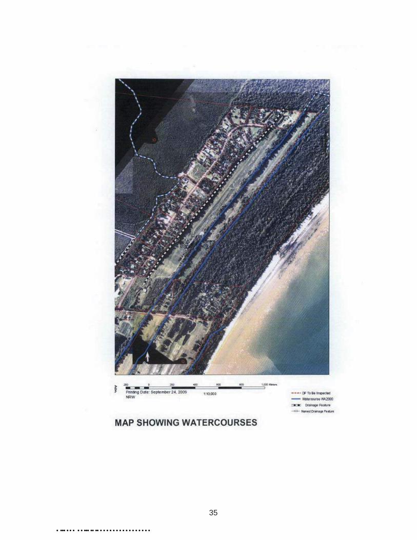
The application relates to a 56.33 hectare rectangular parcel of land situated on the northern side of Vixies Road. The site is mostly cleared of native vegetation with the exception of two distinct vegetated swales extending through the site in a south to north direction being parallel to the beach.
The site is currently improved by a single residence and a lychee orchard in the southern portion of the site.
The applicant has relied upon LIDAR survey (released by Department of Natural Resources & Mines) in conjunction with several detailed survey locations to assist with the layout of the subdivision and more specifically, to determine the vulnerability of the development from flooding impacts. Various boundary characteristics including storm tide events, storm surge tail water levels along with the external contributing catchment for the Average Recurrence Interval (ARI) 1 in 100 year rainfall event has been investigated and analysed to demonstrate the development has adequate flood immunity.
The survey data reveals the topography is characterised by a sandy ridge located between two vegetated swale drains which drain from south to north. Site levels range between approximately 1.25m AHD (bottom of the swale drains) to a little over 4.0m AHD. The site is sheltered from the Coral Sea by a significant coastal mangrove and marine plant buffer having a width of approximately 500 metres.
A mix of land uses are proximate to the site which include rural, rural residential, an aquaculture facility (barramundi farm) and the Pinnacle Village Caravan Park. The large lot to the south of the site between Vixies Road and Snapper Island Drive has an approval to be developed into 99 residential lots.
The proposed development represents a logical extension to the existing rural settlement development of South Arm Drive immediately to the west of the site.
Proposal
The application seeks a Development Permit for the reconfiguration of the land into 72 lots, open space and drainage areas. The layout provides for a new road off Vixies road extending in a northerly direction through the site. The road is positioned on top of an existing ridgeline with lots located either side of the road.
The development is intended to take place in six stages.
For the most part, the lots vary in size from approximately 4000m2 to several hectares. Several very large lots being 70 – 72 are located further east of the vegetated swale drain and sit adjacent to the eastern boundary of the site. These lots will be accessed via a shared access between Lot 48 & Lot 49. The alignment of the access coincides with an existing access through the vegetated swale. The layout also provides a road connection to South Arm Drive between Lots 27 & 28.
The copy of the proposal plans and staging plans form Attachment 1 & Attachment 2 respectively.

58 of 304
Ordinary Meeting - 3 November 2015
Far North Queensland Regional Plan
The site is located within the Regional Landscape and Rural Production Area of the Far North Queensland Regional Plan (FNQRP) in which subdivision for residential purposes is not anticipated or encouraged. However the land is contained within the Rural Settlement Planning Area within the Planning Scheme conferring use rights over the land.
While not included within the Rural Living designation within the Regional Plan, the proposed development will not undermine the intent of the Regional Plan. Adjacent lots are not in agricultural use and the majority of lots are constrained as far as potential agricultural uses due to large areas of remnant vegetation and residential occupation. There is limited opportunity to amalgamate adjacent lots to provide for viable rural land holdings.
The land is identified as containing areas of ecological significance under the Regional Plan being the wetlands within the swales. The land use policies of the Regional Plan requires urban development in or adjacent to areas of general ecological significance to be located, designed and operated to avoid or, where avoidance is not possible, minimise any adverse impacts on the ecological values where possible.
The layout of the development is designed to avoid such adverse impacts on ecological values by protecting the whole of the area within the swales. Conservation covenants will be placed over remnant vegetation and drainage lines within each allotment. The conservation covenants will prohibit any development within the covenanted area as well as prohibiting clearing of vegetation for any purpose.
Douglas Shire Planning Scheme Assessment
Douglas ShireCoastal Suburbs Planning Locality
Code Applicability Compliance
Locality Rural Areas and Rural Settlements Locality Code Complies
Planning Area Rural Settlement Planning Area Code Complies
Overlay Codes Acid Sulfate Soils Conditioned to Comply - see comment belowFilling and Excavation Code Conditioned to Comply – see comments below
Natural Areas and Scenic Amenity Code Conditioned to Comply – see comments below
General Codes
Reconfiguring a Lot Code Complies
Coastal Planning & Flooding Considerations
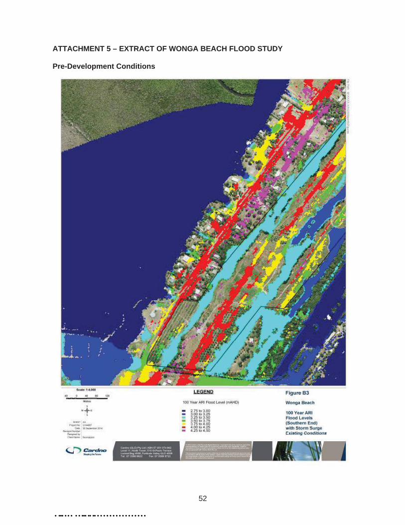
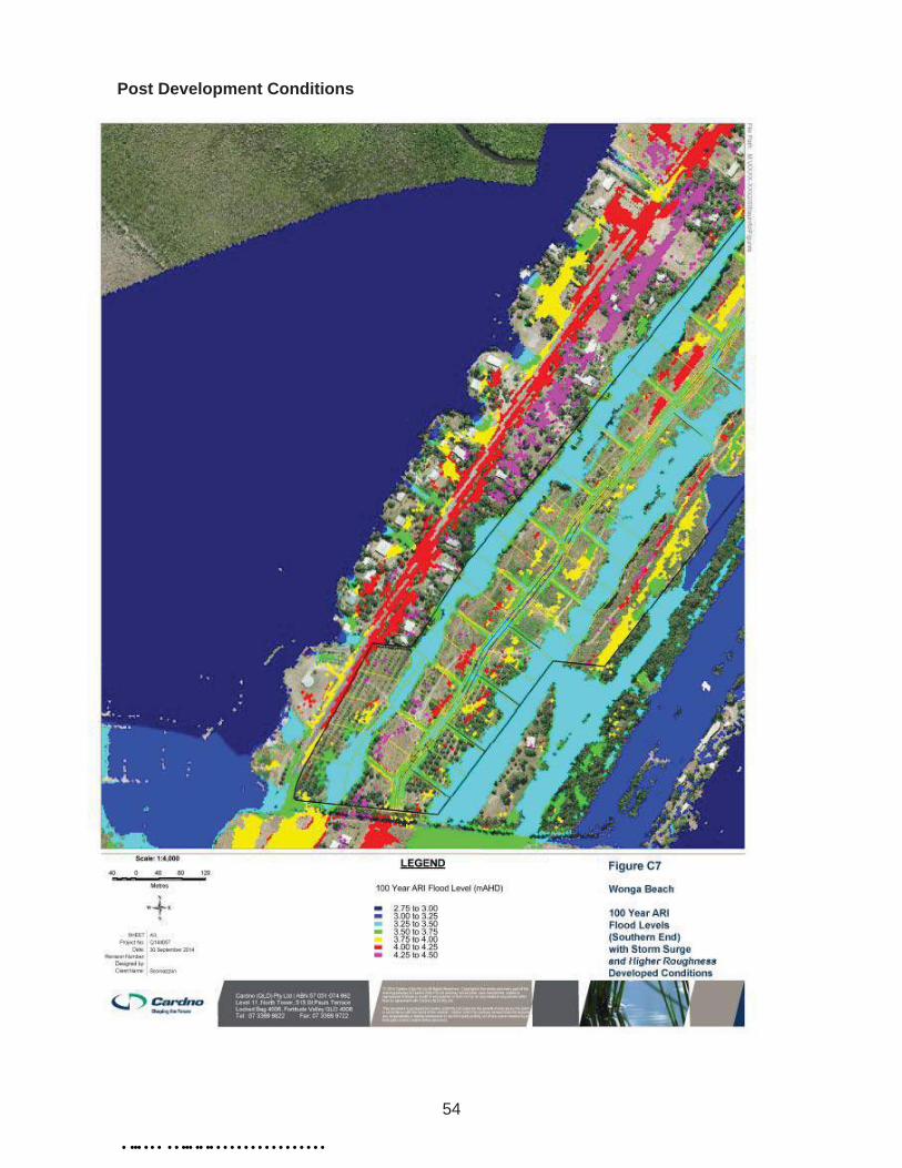
A detailed flood analysis for the site and the contributing catchment was undertaken by Cardno. The flood study calculated the ARI 1 in 100 year rainfall event in conjunction with three possible boundary conditions being:-
1. ocean outlet sanded up to a level of 1.5m AHD;
2. a high tide scenario using Highest Astronomical Tide (HAT) level of 1.78m AHD; and,
3. a 100 year ARI storm tide level (including climate change and 0.8m sea level rise) of 2.8m AHD
Of the three scenarios modelled, the event which had the most impact on the site was the ARI 1 in 100 year rainfall event coinciding with a 100 year ARI storm tide level of 2.8m AHD.
59 of 304
Ordinary Meeting - 3 November 2015
When calculating these levels for this particular event, a higher coefficient for roughness (vegetation in swales) was also used.
The above event results in peak water levels in the range of 3.15m AHD to 3.45m AHD across the site which is generally consistent with the historical development in the local area and beach suburbs of Far North Queensland.
The flood study relied upon LIDAR survey released by Department of Natural Resources & Mines in association with detailed survey of the culverts on Vixies Road and spot levels taken within the site.
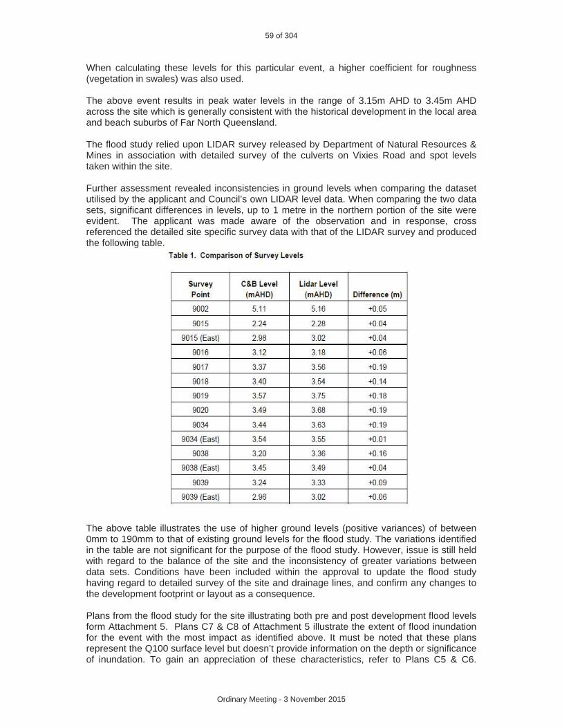
Further assessment revealed inconsistencies in ground levels when comparing the dataset utilised by the applicant and Council’s own LIDAR level data. When comparing the two data sets, significant differences in levels, up to 1 metre in the northern portion of the site were evident. The applicant was made aware of the observation and in response, cross referenced the detailed site specific survey data with that of the LIDAR survey and produced the following table.
The above table illustrates the use of higher ground levels (positive variances) of between 0mm to 190mm to that of existing ground levels for the flood study. The variations identified in the table are not significant for the purpose of the flood study. However, issue is still held with regard to the balance of the site and the inconsistency of greater variations between data sets. Conditions have been included within the approval to update the flood study having regard to detailed survey of the site and drainage lines, and confirm any changes to the development footprint or layout as a consequence.
Plans from the flood study for the site illustrating both pre and post development flood levels form Attachment 5. Plans C7 & C8 of Attachment 5 illustrate the extent of flood inundation for the event with the most impact as identified above. It must be noted that these plans represent the Q100 surface level but doesn’t provide information on the depth or significance of inundation. To gain an appreciation of these characteristics, refer to Plans C5 & C6.

60 of 304
Ordinary Meeting - 3 November 2015
These plans illustrate flows being largely contained to the drainage swales with isolated and scattered areas of inundation within the proposed lots (excluding the drainage swales). The analysis suggests that the extent of inundation within the lots is less than 250mm and would be reflective of depressions and localised variations in ground levels. Minor earthworks of grading and levelling the land would overcome these issues and therefore are not significant.
In relation to earthworks, conditions of approval require a building pad having an area of 1000m2 with a finished pad level being a minimum 300mm above the Q100 ARI flood level for each lot. A condition of approval also requires that where cutting and filling is proposed to achieve the building pad footprint, the applicant must confirm the extent of cut and fill and demonstrate that the proposed work does not have a worsening impact on drainage and flooding. In particular, the areas of the site being cut down do not become more venerable to flooding as a result of the earthworks.
To improve the utility of the lots forming Stage 1 and the absence of environmental constraints at the rear of these lots, it is likely the applicant will seek to re-profile this section of drainage line immediately adjacent Vixies Road. In the event the applicant intends to undertake this work, conditions of approval have been included regarding the alignment of the rear boundary of the lots for Stage 1 to ensure they are appropriately placed with respect to the re-profiled drainage swale.
Road Layout & Local Road Network
The layout provides for a new road off Vixies road extending in a northerly direction through the site. The road is positioned on top of an existing ridgeline with lots located either side of the road. A new road is proposed linking the internal road through to South Arm Drive between Lots 27 and 28. The applicant has suggested that this road be constructed as a single lane road due to vegetation constraints and as a consequence of discussions with Department of Environment and Resource Management (DERM). A single lane road is not supported and conditions of approval require the link road to be a two lane road to connect to South Arm Drive and to achieve certain level of performance as opposed to the road standards set by the FNQROC Development Manual. This is intended to result in minimal disturbance to the drainage swale while ensuring the new road is fit for purpose. It is noted that the conditions forwarded by DERM with regard to the protection of Remnant Vegetation within the drainage swales excludes roads.
The extension of South Arm Drive to connect to Lot 39 in the northern portion of the site is not feasible due to flooding constraints and the extent of works required to gain practical access. As an alternative, Lot 39 is accessed via an access easement from the head of the cul-de-sac.
Stage 1 has frontage to South Arm Drive being a constructed road with access to telecommunications and over head power. The lots comprising Stage 1 are also the least impacted by flood levels as illustrated at Attachment 5.
Filling
In order to comply with conditions of approval, the applicant will be required to undertake filling on certain lots to achieve the minimum flood immunity of 300mm above the Q100 ARI flood level. As detailed above, the applicant will likely pursue a cut and fill option in order to reduce the amount of imported fill.
Details of proposed earthworks and the extent of cut and fill required will form part of the detail associated with the downstream Operational Works submission. It is standard practice

61 of 304
Ordinary Meeting - 3 November 2015
that such detail is investigated and clarified at this stage of the development approval process.
On-Site Sewerage
Investigations undertaken on this site in conjunction with findings of detailed investigations for the site immediately to the south suggest that there is an ability to dispose of effluent onsite in a manner which complies with the Australian Standard.
Concerns were held with regard to the fluctuating water table and high ground water levels which may render certain lots unsuitable for onsite waste disposal. However, sufficient evidence has been provided to indicate that the separation distance of 600mm for advanced secondary systems from ground water can be achieved.
Private Certifiers can only issue building approval for structures containing fixtures once a plumbing approval has been issued by Council in areas not serviced by reticulated sewer. This provides Council with a further opportunity to consider the issue of onsite effluent disposal for each allotment. If the level of ground water and separation distances remains a concern for a particular allotment at this point in time, then there is the opportunity for mounding, or otherwise known as the “Wisconsin Mound” to achieve separation. However based on the information provided and other plumbing approvals issued by Council in the locality over the last 18 months, it is unlikely that this will represent an issue.
Water Supply
The recommendation contains conditions requiring the applicant to investigate the nearest point of connection to service the development. This will involve the extension of the water main along Mossman- Daintree Road and down Vixies Road to the site.
Augmentation of the reticulated water supply required to service the development is not identified in Council’s infrastructure planning undertaken to date.
The approved development of the land to the south (McCloys land) has the ability to service up to 20 lots from Snapper Island before being required to extend the water main in the manner required to service this land.
A condition of approval flags a potential opportunity to obtain infrastructure credits associated with the extension of the water main. A credit arrangement will be entertained whereby the extension has the ability to service external development areas and provides additional capacity over and above that required to service the subject development. Detailed consideration of this matter will be undertaken at the time of seeking Operational Works approval.
Conditions of approval provide for the creation of the five lots fronting South Arm Drive forming Stage 1 of the proposal without the requirement to provide reticulated water as this stage fronts a constructed road, has access to services and is the least constrained lots in the development. It also forms an extension of the existing lots to the east fronting South Arm Drive. However, in order to progress Stage 2 and subsequent stages of the development, reticulated water supply is required.
The ability to service this land and surrounding properties with a reticulated water supply and whether such works will form part of Council’s trunk water supply network will be considered when preparing the Local Government Infrastructure Plan.

62 of 304
Ordinary Meeting - 3 November 2015
Acid Sulfate Soils (ASS)
The volume of earthworks (cut / fill) required to achieve the level of flood immunity required is currently unknown. However it will involve earthworks that will trigger the requirement for a detailed assessment of this issue. A condition is recommended to be placed on the approval to ensure the matter is adequately addressed.
No excavation or filling of the existing natural areas is proposed.
Open Space
The proposed layout identifies a significant area of land opposite Lots 19 – 22 to be dedicated to Council as park. The land is proposed to be dedicated in order to satisfy the developments obligations with respect to open space.
The proposed park lot contains a significant water feature and is undesirable in terms of its features and location. The public demand for open space in this location is extremely low and would be an inefficient use of Council’s resources should this land be dedicated for such a purpose and maintained by Council in perpetuity. Furthermore the presence of a significant water feature is a public hazard.
Conditions of approval do not accept this land as park and advises that such land can be used for residential purposes.
The Infrastructure Charges at Attachment 4 includes a monetary contribution for open space.
Access to Country
The land immediately to the east of this site being Lot 59 on SP204110 has an area of 333.5 hectares and is currently owned in freehold by Jabalbina Yalanji Land Trust as trustee for the land. The land further to the east adjacent the Coral Sea has an area of 220 hectares being Unallocated State Land.
An informal access track exists through the subject land in order to gain access to Lot 59 which then extends through to the beach. The proposal plans at Attachment 1 identifies this track as being the shared access for Lots 71 & 72. Other than an 11 metre wide strip of unconstructed (heavily vegetated) road reserve at the north eastern corner of Pinnacle Village Caravan Park, no other lawful or practical access is available.
The Applicant has advised that local indigenous people and other locals often use this track in order to gain access to the beach. The Applicant has expressed his interest in formalising this track and opening this section of track as a continuation of road reserve. Earlier proposal plans identified a road extending to the eastern boundary and a car park to formalise beach access.
Access onto Lot 59 is restricted by a locked gate on the eastern boundary. It is understood that the key/s to the gate are held by local indigenous people.
Illustrations are provided below.

63 of 304
Ordinary Meeting - 3 November 2015
Beach Access
Informal track through the land gaining access to Lot 59. Note access onto the beach (bottom right corner)
Earlier proposal plan nominating new road and car park to eastern boundary

64 of 304
Ordinary Meeting - 3 November 2015
Esplanade frontage to Lot 59 (north east corner of Pinnacle Village Caravan Park)
In order to improve lawful and practical access to Lot 59, is recommended that an access easement over proposed Lot 72 be granted in favour of Lot 59 on SP204110. This option is preferable over the proposal of opening new road which will encourage and promote general public access through to the beach which requires traversing freehold land.
How general public access is managed once the development is created is a matter for the owners of the residential lots and Jabalbina Yalanji Land Trust.
Referral Agency Requirements
The application was referred to the former Department of Environment and Resource Management (now DEHP) as a Concurrence and Advice Agency and the Department of Main Roads (now DTMR) as a Concurrence Agency.
Key conditions imposed by the agencies seek to protect the remnant vegetation within the drainage swales through the placement of such areas within conservation covenants in addition to requiring an upgrade to the intersection of Vixies Road and Mossman-Daintree Road.
The intersection upgrade is required prior to the creation of any lots within the development. The applicant has the ability to request a change to this condition through direct discussions with DTMR particularly with regard to the release of Stage 1 as detailed at Attachment 2.
Referral agencies responses form Attachment 3.
ADOPTED INFRASTRUCTURE CHARGES
The Development triggers infrastructure charges. A copy of the calculation forms Attachment 4.
65 of 304
Ordinary Meeting - 3 November 2015
COUNCIL’S ROLE
Council can play a number of different roles in certain circumstances and it is important to be clear about which role is appropriate for a specific purpose or circumstance. The implementation of actions will be a collective effort and Council’s involvement will vary from information only through to full responsibility for delivery.
The following area outlines where Council has a clear responsibility to act:
Regulator: Meeting the responsibilities associated with regulating activities through legislation or local law.
Under the Sustainable Planning Act 2009 and the Sustainable Planning Regulation 2009, Council is the assessment manager for the application.
ATTACHMENTS
Attachment 1 – Approved Plan(s) & Document(s) Attachment 2 – Staging PlansAttachment 3 – Concurrence Agency Conditions & RequirementsAttachment 4 –Attachment 5
Infrastructure ChargesExtract of Wonga Beach Flood Study (Pre & Post Development)

22
ATTACHMENT 1 – APPROVED PLANS
• ••• • • • • • ••• •• •• • • • • • • • • • • • • • • • •

23
• ••• • • • • • ••• •• •• • • • • • • • • • • • • • • • •

24
• ••• • • • • • ••• •• •• • • • • • • • • • • • • • • • •

25
ATTACHMENT 2 – STAGING PLANS
• ••• • • • • • ••• •• •• • • • • • • • • • • • • • • • •

26
• ••• • • • • • ••• •• •• • • • • • • • • • • • • • • • •

27
• ••• • • • • • ••• •• •• • • • • • • • • • • • • • • • •
28
ATTACHMENT 3 – CONCURRENCE AGENCY CONDITIONS & REQUIREMENTS
• ••• • • • • • ••• •• •• • • • • • • • • • • • • • • • •

29
• ••• • • • • • ••• •• •• • • • • • • • • • • • • • • • •

30
• ••• • • • • • ••• •• •• • • • • • • • • • • • • • • • •

31
• ••• • • • • • ••• •• •• • • • • • • • • • • • • • • • •

32
• ••• • • • • • ••• •• •• • • • • • • • • • • • • • • • •

33
• ••• • • • • • ••• •• •• • • • • • • • • • • • • • • • •

34
• ••• • • • • • ••• •• •• • • • • • • • • • • • • • • • •
35
• ••• • • • • • ••• •• •• • • • • • • • • • • • • • • • •
36
• ••• • • • • • ••• •• •• • • • • • • • • • • • • • • • •

37
• ••• • • • • • ••• •• •• • • • • • • • • • • • • • • • •

38
• ••• • • • • • ••• •• •• • • • • • • • • • • • • • • • •

39
• ••• • • • • • ••• •• •• • • • • • • • • • • • • • • • •

40
• ••• • • • • • ••• •• •• • • • • • • • • • • • • • • • •

41
• ••• • • • • • ••• •• •• • • • • • • • • • • • • • • • •

42
• ••• • • • • • ••• •• •• • • • • • • • • • • • • • • • •

43
• ••• • • • • • ••• •• •• • • • • • • • • • • • • • • • •

44
• ••• • • • • • ••• •• •• • • • • • • • • • • • • • • • •

45
• ••• • • • • • ••• •• •• • • • • • • • • • • • • • • • •

46
• ••• • • • • • ••• •• •• • • • • • • • • • • • • • • • •

47
• ••• • • • • • ••• •• •• • • • • • • • • • • • • • • • •
48
• ••• • • • • • ••• •• •• • • • • • • • • • • • • • • • •

49
• ••• • • • • • ••• •• •• • • • • • • • • • • • • • • • •

50
• ••• • • • • • ••• •• •• • • • • • • • • • • • • • • • •

51
ATTACHMENT 4 – INFRASTRUCTURE CHARGES
• ••• • • • • • ••• •• •• • • • • • • • • • • • • • • • •
52
ATTACHMENT 5 – EXTRACT OF WONGA BEACH FLOOD STUDY
Pre-Development Conditions
• ••• • • • • • ••• •• •• • • • • • • • • • • • • • • • •

53
• ••• • • • • • ••• •• •• • • • • • • • • • • • • • • • •
54
Post Development Conditions
• ••• • • • • • ••• •• •• • • • • • • • • • • • • • • • •

55
• ••• • • • • • ••• •• •• • • • • • • • • • • • • • • • •

56
Depth of Flows
• ••• • • • • • ••• •• •• • • • • • • • • • • • • • • • •

57
• ••• • • • • • ••• •• •• • • • • • • • • • • • • • • • •