The tectonic construction of a façade. Milanese buildings ...
Upload
nguyenlienCategory
view
215download
0
Reopening the “Navigli” canals in Milan Summary of the project
There have been talks of reopening the existing canals in Milan for decades. Our project, which proposes the total reopening of the “Navigli” canals buried when the historical city plan changed between 1929 and the ‘60s, has been studied by the Milan Polytechnic between 2008 and 2010. Preliminary studies have shown that the project of reopening the “inner trench” is feasible from an architectural and engineering point of view, and is suitable for the environmental requalification of the city, the re-organization of the transport system to improve urban mobility and to re-establish Milan as a traditional “water city”. The project, of great value from an environmental and landscape point of view, could give back its old charm to the whole town, restoring the great Milan and Lombardy waterway system, which could again fulfil its proper transport function, especially of a touristic kind, from Lake Maggiore and Lake Como to the river Po towards Venice and the Adriatic Sea. Reopening the Navigli canals represents for Milan a new urban, environmental and economic strategy. It’s an extraordinary occasion to upgrade the town along its canals routes and many nearby areas, above and under ground. A special opportunity to invest in quality and to create new activities and roles. The reopened Navigli will attract tourists from all over the world, contributing to reinforce the tourism-related economy and increasing the value of Milan’s architectural heritage. Needless to say, the project does not wish to carry out an impossible philological and antiquarian “reconstruction” of the historical canals but aims at rebuilding a new landscape along with new opportunities for development of the town, based on its historical waterway plan.
Project features
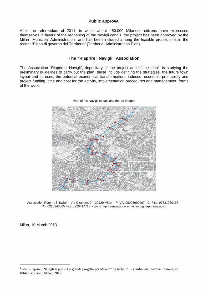
The project plans to carry out the realization of eight and a half kilometres of canal, with 25 bridges, from the Cassina de Pom location, where the Naviglio Martesana sinks under via Melchiorre Gioia, up to the Darsena; the canal will go through the entire Via Melchiorre Gioia, via San Marco, the inner belt and the conca dei Navigli. The Navigli will be reopened following the water flow, which enters Milan coming from the Adda river and the already existing Naviglio Martesana. The first tract, which goes through via Melchiorre Gioia towards via San Marco and via Pontaccio, represents a great opportunity for the re-qualification of the town in the areas which have been transformed more recently, including those around the Garibaldi-Repubblica area, and in those areas which still show evident signs of the old Navigli, down-river via San Marco and up-river at the Conca dell’Incoronata. From corso di Porta Vittoria to corso di Porta Romana, the Naviglio is an element of continuity of the town’s main municipal functions: the Central Public Library in Palazzo Sormani, the Palace of Justice, the Umanitaria Society, the Guastalla gardens, the State University in Via Festa del Perdono, the historical buildings of the Policlinico Hospital in via Francesco Sforza.

The present Cerchia dei Navigli will be open to traffic for residents only and to public transport. The traffic which now uses the Cerchia as inner belt can be easily transferred to the Cerchia dei Bastioni of the Mura Spagnole, as already planned and approved by Milan Municipality’s traffic management plan of 2003-2006. Along via Francesco Sforza, via Santa Sofia and via De Amicis, the Naviglio will flow over the new metro line M4 and overpass with no problems the metro lines M1 and M3. A fundamental part of the project is the design of the Conca del Naviglio tract, in the street with the same name, as an urban public space in connection to other spaces and green areas all around it, including the pedestrian zones which link it with the roman arena up to the Parco delle Basiliche and the Darsena. Reopening the canals will spur the creation of new pedestrian areas which, along with the already existing ones, will form a network of non-motorised mobility. A Navigli tourist transport service will be carried out by boats and will complement the mobility offer. Reopening the Navigli canals will allow the reactivation of the link to the Adda-Ticino waterway: an infrastructure of about 70 Km, in a landscape of rare beauty, along which it will be possible to open one of the longest bicycle paths in Europe with all the relative tourist facilities.
Economic advantages The Naviglio will be a source of cost-effective enterprises in the tourist and energy sectors, and in other activities. The new network of canals will be not only a landscape system which will transform the town’s landscape and quality of life, but also a complex technological creation which will be of great use in several public areas, including: • energy: using the water flow to produce energy (micro turbines, heat pumps , etc.) • hydraulic: rationalizing the hydraulic system and water usage in the Milan area; • information technology: creating fibre optic conduits and other infrastructures for information
and communication; • thermal: developing teleheating; • subsoil exploiting: creation of new parking places, management of supply and storage of
goods, garbage and waste products pickup, other technological galleries.
The creation of the new Navigli network will spur new economical activities deriving from: • management of water resources, • management of leisure time infrastructures, restaurant and accommodation industry, • management of new cultural and touristic activities, • valorisation of buildings along the Navigli, with increased possibility of re-qualification and
reclamation, • new potential real estate activities with new functions and services.
Costs and financial feasibility
Total estimate for the architectural and engineering works needed to carry out the project amounts to 120 - 150 million Euros, less than the cost of 3 kilometres of underground. The project can be financed by private and public sources, in an articulated funding plan. Various forms of financing will be explored, such as: project-financing, public funding by municipal and regional sources, donations by authorities or companies; donations or supporter’s trusts, income by advertising; European funding projects of the smart cities type.
Public approval
After the referendum of 2011, in which about 450.000 Milanese citizens have expressed themselves in favour of the reopening of the Navigli canals, the project has been approved by the Milan Municipal Administration and has been included among the feasible propositions in the recent “Piano di governo del Territorio” (Territorial Administration Plan).
The “Riaprire i Navigli” Association
The Association “Riaprire i Navigli”, depositary of the project and of the idea1, is studying the preliminary guidelines to carry out the plan; these include defining the strategies, the future town layout and its uses, the potential economical transformations induced, economic profitability and project funding, time and cost for the activity, implementation procedures and management forms of the work.
Plan of the Navigli canals and the 25 bridges
Association Riaprire i Navigli – Via Ozanam, 9 – 20129 Milan – P.IVA: 08093690967 - C. Fisc: 97631960156 – Ph: 0220240585 Fax: 0229417717 - www.riaprireinavigli.it – email: [email protected]
Milan, 10 March 2013
1 See “Riaprire i Navigli si può – Un grande progetto per Milano” by Roberto Biscardini and Andrea Cassone, ed. Biblion edizioni, Milan, 2012.