Remote Telepresence for Exploring Virtual Worlds
37
Remote Telepresence for Exploring Virtual Worlds Foundational Talk Virtual World and Immersive Environments January 26, 2008 Dr. Larry Smarr Director, California Institute for Telecommunications and Information Technology Harry E. Gruber Professor, Dept. of Computer Science and Engineering Jacobs School of Engineering, UCSD
-
Upload
larry-smarr -
Category
Technology
-
view
412 -
download
0
Transcript of Remote Telepresence for Exploring Virtual Worlds

Remote Telepresence for Exploring Virtual Worlds
Foundational Talk
Virtual World and Immersive Environments
January 26, 2008
Dr. Larry Smarr
Director, California Institute for Telecommunications and Information Technology
Harry E. Gruber Professor,
Dept. of Computer Science and Engineering
Jacobs School of Engineering, UCSD

The NSFnet (Later Expands to Form Today’s Internet) Connected the Six NSF Supercomputers at 56kbps!
NCSANCSA
NSFNET 56 Kb/s Backbone (1986-8)
PSCPSCNCARNCAR
CTCCTC
JVNCJVNC
SDSCSDSC
• Televisualization:– Telepresence– Remote Interactive
Visual Supercomputing
– Multi-disciplinary Scientific Visualization
A Simulation of Telepresence for Exploring Virtual Worlds: Using Analog Communications to Prototype the Digital Future
“We’re using satellite technology…to demowhat It might be like to have high-speed fiber-optic links between advanced computers in two different geographic locations.”
― Al Gore, SenatorChair, US Senate Subcommittee on Science, Technology and Space
Illinois
Boston
SIGGRAPH 1989
ATT & Sun
“What we really have to do is eliminate distance between individuals who want to interact with other people and with other computers.”― Larry Smarr, Director, NCSA

The CAVE Virtual Reality System:Fully Immersive Science and Fantasy Worlds
CAVE conceived in 1991 by Tom DeFanti and Dan Sandin (EVL co-directors) and implemented by Carolina Cruz-Neira (Ph.D. student)
Crayoland
Colliding Galaxies QUAKE II
The CAVE
• EVL Invents ‘91• Debuts SIGGRAPH ’92• National Access NCSA ‘93

Kids Building Virtual CitiesSupercomputing ‘95 San Diego
UIC
• First User-Generated Virtual World
– Coco Conn (producer), Zane Vella (director), Chris Cederwall (programmer), et al.
– Ported to CAVE SIGGRAPH ’94
– Networked Over I-Way ‘95CitySpace
http://en.wikipedia.org/wiki/CityspaceI-WAY 155 Mbps

Caterpillar / NCSA: Distributed Virtual Reality for Global-Scale Collaborative Prototyping
Real Time Linked Virtual Reality and Audio-Video Between NCSA, Peoria, Houston, and Germany
www.sv.vt.edu/future/vt-cave/apps/CatDistVR/DVR.html1996
Floating Rendered Video

Grid-Enabled Collaborative Analysisof Ecosystem Dynamics Datasets
Chesapeake Bay Data in Collaborative Virtual Environment
Alliance Application TechnologiesEnvironmental Hydrology Team
1997
Donna Cox, Robert Patterson, Stuart Levy, NCSA Virtual Director TeamGlenn Wheless, Old Dominion Univ.
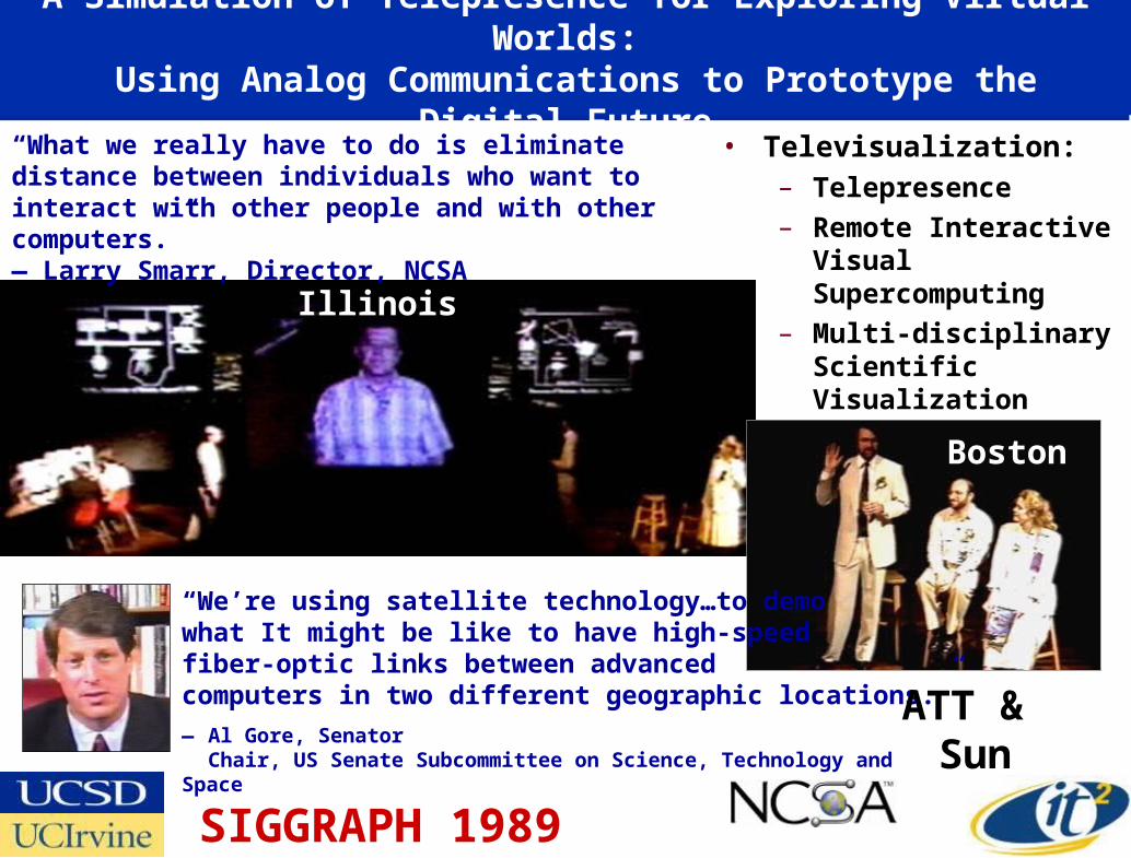
Two New Calit2 Buildings Provide New Laboratories for “Living in the Future”
• “Convergence” Laboratory Facilities– Nanotech, BioMEMS, Chips, Radio, Photonics
– Virtual Reality, Digital Cinema, HDTV, Gaming
• Over 1000 Researchers in Two Buildings– Linked via Dedicated Optical Networks
UC Irvinewww.calit2.net
Preparing for a World in Which Distance is Eliminated…

September 26-30, 2005Calit2 @ University of California, San Diego
California Institute for Telecommunications and Information Technology
Borderless CollaborationBetween Global University Research Centers at 10Gbps
iGrid
2005T H E G L O B A L L A M B D A I N T E G R A T E D F A C I L I T Y
Maxine Brown, Tom DeFanti, Co-Chairs
www.igrid2005.org
100Gb of Bandwidth into the Calit2@UCSD BuildingMore than 150Gb GLIF Transoceanic Bandwidth!450 Attendees, 130 Participating Organizations
20 Countries Driving 49 Demonstrations1- or 10- Gbps Per Demo

First Trans-Pacific Super High Definition Telepresence Meeting Using Digital Cinema 4k Streams
Keio University President Anzai
UCSD Chancellor Fox
Lays Technical Basis for
Global Digital
Cinema
Sony NTT SGI
Streaming 4k with JPEG 2000 Compression ½ gigabit/sec
100 Times the Resolution
of YouTube!
Calit2@UCSD Auditorium
4k = 4000x2000 Pixels = 4xHD

Interactive VR Streamed Live from Tokyo to Calit2 Over Dedicated GigE and Projected at 4k Resolution
Source: Toppan Printing
iGrid 2005Kyoto Nijo
Castle

The OptIPuter Project: Creating High Resolution Portals Over Dedicated Optical Channels to Global Science Data
Picture Source:
Mark Ellisman,
David Lee, Jason Leigh
Calit2 (UCSD, UCI) and UIC Lead Campuses—Larry Smarr PIUniv. Partners: SDSC, USC, SDSU, NW, TA&M, UvA, SARA, KISTI, AIST
Industry: IBM, Sun, Telcordia, Chiaro, Calient, Glimmerglass, Lucent
$13.5M Over Five
Years
Scalable Adaptive Graphics
Environment (SAGE)

My OptIPortalTM – AffordableTermination Device for the OptIPuter Global Backplane
• 20 Dual CPU Nodes, 20 24” Monitors, ~$50,000• 1/4 Teraflop, 5 Terabyte Storage, 45 Mega Pixels--Nice PC!• Scalable Adaptive Graphics Environment ( SAGE) Jason Leigh, EVL-UIC
Source: Phil Papadopoulos SDSC, Calit2

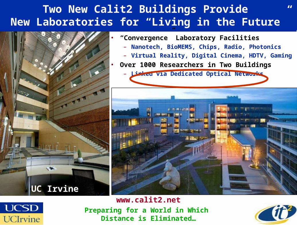
Tiled Displays Allow for Both Global Context and High Levels of Detail—150 MPixel Rover Image on 40 MPixel OptIPuter Visualization Node Display
"Source: Spirit Rover Landing Site Panorama, Data from JPL/Mica; Display UCSD NCMIR, David Lee"

Interactively Zooming In Using UIC’s Electronic Visualization Lab’s JuxtaView Software
"Source: Data from JPL/Mica; Display UCSD NCMIR, David Lee"
Highest Resolution Zoom
"Source: Data from JPL/Mica; Display UCSD NCMIR, David Lee"

Beyond 4k – From 8 Megapixels Towards a Billion Pixels
Calit2@UCI Apple Tiled Display WallDriven by 25 Dual-Processor G5s
50 Apple 30” Cinema Displays
Source: Falko Kuester, Calit2@UCINSF Infrastructure Grant
Data—One Foot Resolution USGS Images of La Jolla, CA
HDTV
Digital Cameras Digital Cinema

OptIPuter Enables Telepresence Combined with Remote Interactive Analysis
OptIPuter Visualized
Data
HDTV Over
Lambda
Live Demonstration
of 21st Century National-Scale Team Science
August 12, 2005SIO/UCSD NASA Goddard

The OptIPuter Enabled Collaboratory:Remote Researchers Jointly Exploring Complex Data
OptIPuter Connectsthe Calit2@UCI
200M-Pixel Wall tothe 220M-Pixel Displayat Calit2@UCSD With
Shared Fast Deep Storageand High Definition Video
UCI
UCSD
Falko Kuester, UCSD; Steven Jenks, UCI
80 NVIDIA Quadro FX 5600 GPUs
2,000 Mbps
Brain Circuitry Modeling and Visualization In Collaboration with the
Transdisciplinary Imaging Genetics Center (TIGC) at UCI

Source: Maxine Brown, OptIPuter Project Manager
GreenInitiative:
Can Optical Fiber Replace Airline Travel
for Continuing Collaborations
?

OptIPortalsAre Being Adopted Globally
NCMIR@UCSDEVL@UIC Calit2@UCI
KISTI-Korea
Calit2@UCSD
AIST-Japan
UZurich
CNIC-China
NCHC-Taiwan
Osaka U-Japan
SARA- Netherlands Brno-Czech Republic

Launch of the 100 Megapixel OzIPortal Over Qvidium Compressed HD on 1 Gbps CENIC/PW/AARNet Fiber
www.calit2.net/newsroom/release.php?id=1219

“Using the Link to Build the Link”Calit2 and Univ. Melbourne Technology Teams
www.calit2.net/newsroom/release.php?id=1219
No Calit2 Person Physically Flew to Australia to Bring This Up!
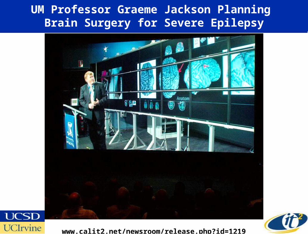
UM Professor Graeme Jackson Planning Brain Surgery for Severe Epilepsy
www.calit2.net/newsroom/release.php?id=1219

Victoria Premier and Australian Deputy Prime Minister Asking Questions
www.calit2.net/newsroom/release.php?id=1219

University of Melbourne Vice Chancellor Glyn Davis in Calit2 Replies to Question from Australia
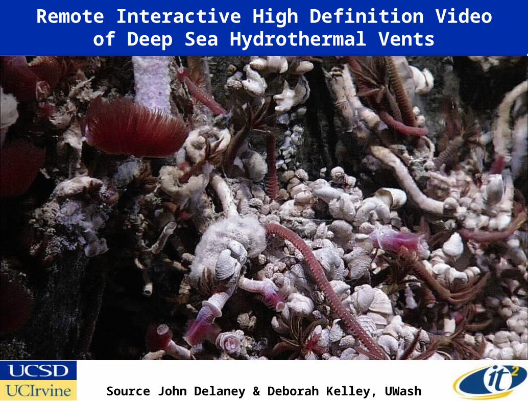
Remote Interactive High Definition Videoof Deep Sea Hydrothermal Vents
Source John Delaney & Deborah Kelley, UWash
Canadian-U.S. Collaboration

e-Science Collaboratory Without Walls Enabled by iHDTV Uncompressed HD Telepresence
Photo: Harry Ammons, SDSC
John Delaney, PI LOOKING, Neptune
May 23, 2007
1500 Mbits/sec Calit2 to UW Research Channel Over NLR

Creating a Digital MooreaCalit2 Collaboration with UC Gump Station (UCB, UCSB)

3D OptIPortals: Calit2 StarCAVE and VarrierAlpha Tests of Telepresence “Holodecks”
Cluster with 30 Nvidia 5600 cards-60 GB Texture Memory
Source: Tom DeFanti, Greg Dawe, Calit2
Connected at 20 Gb/s to CENIC, NLR, GLIF
30 HD Projectors!
15 Meyer Sound Speakers + Subwoofer
Passive Polarization--Optimized the
Polarization Separation and Minimized Attenuation

The StarCAVE as a “ Browser” for the NASA’s “Blue Marble” Earth Dataset
Source: Tom DeFanti, Jurgen Schulze, Bob Kooima, Calit2/EVL

3D Videophones Are Here! The Personal Varrier Autostereo Display
• Varrier is a Head-Tracked Autostereo Virtual Reality Display– 30” LCD Widescreen Display with 2560x1600 Native Resolution
– A Photographic Film Barrier Screen Affixed to a Glass Panel
• Cameras Track Face with Head Tracker to Locate Eyes• The Display Eliminates the Need to Wear Special Glasses
Source: Daniel Sandin, Thomas DeFanti, Jinghua Ge, Javier Girado, Robert Kooima, Tom Peterka—EVL, UIC

Varrier Barrier Strip Auto-StereoQuick Review
• Columns of right and left eye images viewed through slits
R L R L R L R L R L R L R L R L
Source: Dan Sandin, EVL/ Calit2

EVL/Calit2’s Varrier Developer Dan Sandin Explains How it Works
Source: Dan Sandin, EVL/ Calit2

Calit2/EVL Varrier --60 Screen Stereo OptIPortal, no Glasses Needed
Dan Sandin, Greg Dawe, Tom Peterka, Tom DeFanti, Jason Leigh, Jinghua Ge, Javier Girado, Bob Kooima, Todd Margolis, Lance Long, Alan Verlo, Maxine Brown,
Jurgen Schulze, Qian Liu, Ian Kaufman, Bryan Glogowski
Mars Rendered at 46,000 x 23,000 pixels

Exploring Virtual Mars with the Varrier
Source: Dan Sandin, EVL/ Calit2

The Mars demo integrates data from 3 sources. The primary data set is a topographical map collected by Mars Global Surveyor (MGS), a sun-synchronous polar orbiting Mars probe launched by NASA/JPL in 1996. The data was collected between 1996 and 2001, though the probe remains functional as a communications relay in Mars orbit to this day. Topographic measurement was performed by the Mars Orbiter Laser Altimeter (MOLA), giving planetary radius with 1 meter precision at a resolution of 128 pixels per degree, or approximately half a kilometer at the equator.
Topographical data is textured using color imagery composited and color-matched from NASA's Viking Orbiter data collected during the late 70s. The color data has a resolution of approximately 64 pixels per degree. The background starfield is the Hipparcos catalog, a database of 120,000 nearby stars collected by the ESA's HIPPARCOS satellite between 1989 and 1993, rendered as correctly scaled and colored points.
The total size of the topographical data set is 46080 by 22528 pixels. At 16-bit precision it consumes 2GB of storage. When rendered using OpenGL, a position, normal, and texture coordinate must be computed per pixel. This expands the data set out to over 30GB, much too large to be rendered efficiently.
A topo data caching mechanism was designed to enable real-time display on the Varrier. To begin, the raw topo data set is mipmapped using a linear filter, giving a pyramid of data sets of decreasing resolutions. For each rendered frame, a level-of-detail algorithm recursively subdivides the surface of Mars into square areas, determines which of these areas are visible, and computes the minimum resolution for the optimal display of each. For each visible area, a 45-by-45 vertex geometry page is generated from the raw mipmap level that most-closely matches the optimal resolution of that area. These 45-by-45 vertex pages are streamed directly to the video RAM of the graphics board, and stored there under a least-recently-used caching policy. The smooth motion of the viewpoint provides a locality of reference that ensures efficient use of this VRAM geometry cache. This mechanism cycles approximately 40 times per second, with each of the 33 nodes of the 65-panel Varrier maintaining a separate parallel cache representing its own subset of the total view.