
Remote Sensing of Environment - NASA · Remote Sensing of Environment 143 (2014) 85–96 ⁎...
12
The New VIIRS 375 m active fire detection data product: Algorithm description and initial assessment Wilfrid Schroeder a, ⁎, Patricia Oliva a , Louis Giglio a , Ivan A. Csiszar b a Department of Geographical Sciences, University of Maryland, College Park, MD, United States b NOAA/NESDIS Center for Satellite Applications and Research, College Park, MD, United States abstract article info Article history: Received 14 October 2013 Received in revised form 16 December 2013 Accepted 17 December 2013 Available online xxxx Keywords: Active fire detection S-NPP/VIIRS MODIS The first Visible Infrared Imaging Radiometer Suite (VIIRS) was launched in October 2011 aboard the Suomi- National Polar-orbiting Partnership (S-NPP) satellite. The VIIRS instrument carries two separate sets of multi- spectral channels providing full global coverage at both 375 m and 750 m nominal resolutions every 12 h or less depending on the latitude. In this study, we introduce a new VIIRS active fire detection algorithm, which is driven primarily by the 375 m middle and thermal infrared imagery data. The algorithm builds on the well-established MODIS Fire and Thermal Anomalies product using a contextual approach to detect both day and nighttime biomass burning and other thermal anomalies. Here we present the fire algorithm's design and imple- mentation, including important information describing the input data characteristics and potential artifacts associ- ated with pixel saturation and the South Atlantic Magnetic Anomaly, both found to affect the middle infrared channel data. Initial assessment using results derived from the global processing of the algorithm indicated small, although variable, commission errors (b 1.2%) for nominal confidence fire pixels. We achieved improved perfor- mance using the 375 m active fire data compared to the VIIRS 750 m baseline fire product, resulting in a 3× and 25× factor increase in the absolute number of fire pixels detected using day and nighttime data, respectively. Similarly, VIIRS 375 m fire data showed significantly superior mapping capabilities compared to current MODIS fire detection data with improved consistency of fire perimeter delineation for biomass burning lasting multiple days. © 2014 Elsevier Inc. All rights reserved. 1. Introduction The Visible Infrared Imaging Radiometer Suite (VIIRS) was launched in October 2011 aboard the Suomi National Polar-orbiting Partnership (S-NPP) satellite, a United States mission jointly managed by the National Aeronautics and Space Administration (NASA) and the National Oceanic and Atmospheric Administration (NOAA). The S-NPP serves as a preparatory mission to the upcoming Joint Polar Satellite System (JPSS), while delivering operational data products (Hillger et al., 2013). The JPPS program will provide continuity to the multi-decadal polar orbit environmental satellite data record that includes NOAA's Advanced Very High Resolution Radiometer (AVHRR) and NASA's Moderate Resolution Imaging Spectroradiometer (MODIS) data, and is complemented by data from the Defense Meteorological Satellite Program (DMSP) (Justice et al., 2013). These different satellite data sets have been used in support of a variety of active fire and biomass burning products and applications (Davies, Ilavajhala, Wong, & Justice, 2009; Elvidge et al., 1996; Flasse & Ceccato, 1996; Giglio, Descloitres, Justice, & Kaufman, 2003; Giglio, Loboda, Roy, Quayle, & Justice, 2009; Ichoku, Giglio, Wooster, & Remer, 2008; Roy, Boschetti, Justice, & Ju, 2008). The resulting fire products have reached different levels of maturity based on validation analyses and algorithm refinements made over the years, with the MODIS Fire and Thermal Anomalies algorithm (MOD14 and MYD14) becoming the most developed and widely used fire data set in the last decade (Giglio et al., 2003; Morisette, Giglio, Csiszar, & Justice, 2005; Schroeder et al., 2008). The operational land products derived from the new VIIRS data include key Environmental Data Records (EDRs), and the Active Fires Application Related Product (ARP) in support of primarily weather applications (Justice et al., 2013). Originally, the VIIRS Active Fires ARP built on the 750 m channel data containing sparse array output data in- cluding the geographic (latitude and longitude) and image (row and column indices) coordinates, and associated quality flags describing fire-affected pixels (Csiszar et al., in press). The algorithm used to gen- erate the current operational VIIRS 750 m Active Fires ARP builds on the MODIS Collection 4 fire algorithm (Giglio et al., 2003), applying vir- tually the same combination of tests to the corresponding VIIRS 750 m multi-spectral data. Subsequent revision of VIIRS land product require- ments for the upcoming JPSS upgraded the 750 m Active Fires ARP product to the category of EDR. The revised requirements incorporated algorithm updates and additional layers to the product including a 2D image classification array (fire mask), a pixel-based fire characterization parameter (Fire Radiative Power [FRP]), among other features. The revised active fire product will be gradually integrated into the current Remote Sensing of Environment 143 (2014) 85–96 ⁎ Corresponding author at: Department of Geographical Sciences, University of Maryland, 2181 LeFrak Hall, College Park, MD 20742, United States. Tel.: +1 202 341 7763. E-mail address: [email protected] (W. Schroeder). 0034-4257/$ – see front matter © 2014 Elsevier Inc. All rights reserved. http://dx.doi.org/10.1016/j.rse.2013.12.008 Contents lists available at ScienceDirect Remote Sensing of Environment journal homepage: www.elsevier.com/locate/rse
Transcript of Remote Sensing of Environment - NASA · Remote Sensing of Environment 143 (2014) 85–96 ⁎...

Remote Sensing of Environment 143 (2014) 85–96
Contents lists available at ScienceDirect
Remote Sensing of Environment
j ourna l homepage: www.e lsev ie r .com/ locate / rse
The New VIIRS 375 m active fire detection data product: Algorithmdescription and initial assessment
Wilfrid Schroeder a,⁎, Patricia Oliva a, Louis Giglio a, Ivan A. Csiszar b
a Department of Geographical Sciences, University of Maryland, College Park, MD, United Statesb NOAA/NESDIS Center for Satellite Applications and Research, College Park, MD, United States
⁎ Corresponding author at: Department of GeograMaryland, 2181 LeFrakHall, College Park,MD20742, Unite
E-mail address: [email protected] (W. Schro
0034-4257/$ – see front matter © 2014 Elsevier Inc. All rihttp://dx.doi.org/10.1016/j.rse.2013.12.008
a b s t r a c t
a r t i c l e i n f oArticle history:Received 14 October 2013Received in revised form 16 December 2013Accepted 17 December 2013Available online xxxx
Keywords:Active fire detectionS-NPP/VIIRSMODIS
The first Visible Infrared Imaging Radiometer Suite (VIIRS) was launched in October 2011 aboard the Suomi-National Polar-orbiting Partnership (S-NPP) satellite. The VIIRS instrument carries two separate sets of multi-spectral channels providing full global coverage at both 375 m and 750 m nominal resolutions every 12 h orless depending on the latitude. In this study, we introduce a new VIIRS active fire detection algorithm, which isdriven primarily by the 375 m middle and thermal infrared imagery data. The algorithm builds on thewell-established MODIS Fire and Thermal Anomalies product using a contextual approach to detect both day andnighttime biomass burning and other thermal anomalies. Here we present the fire algorithm's design and imple-mentation, including important information describing the input data characteristics and potential artifacts associ-ated with pixel saturation and the South Atlantic Magnetic Anomaly, both found to affect the middle infraredchannel data. Initial assessment using results derived from the global processing of the algorithm indicated small,although variable, commission errors (b1.2%) for nominal confidence fire pixels. We achieved improved perfor-mance using the 375 m active fire data compared to the VIIRS 750 m baseline fire product, resulting in a 3× and25× factor increase in the absolute number of fire pixels detected using day and nighttime data, respectively.Similarly, VIIRS 375 m fire data showed significantly superior mapping capabilities compared to current MODISfire detection data with improved consistency of fire perimeter delineation for biomass burning lasting multipledays.
© 2014 Elsevier Inc. All rights reserved.
1. Introduction
The Visible Infrared Imaging Radiometer Suite (VIIRS) was launchedin October 2011 aboard the Suomi National Polar-orbiting Partnership(S-NPP) satellite, a United States mission jointly managed by theNational Aeronautics and Space Administration (NASA) and the NationalOceanic and Atmospheric Administration (NOAA). The S-NPP serves as apreparatory mission to the upcoming Joint Polar Satellite System (JPSS),while delivering operational data products (Hillger et al., 2013). TheJPPS program will provide continuity to the multi-decadal polar orbitenvironmental satellite data record that includes NOAA's Advanced VeryHigh Resolution Radiometer (AVHRR) and NASA's Moderate ResolutionImaging Spectroradiometer (MODIS) data, and is complemented bydata from the Defense Meteorological Satellite Program (DMSP) (Justiceet al., 2013). These different satellite data sets have been used in supportof a variety of active fire and biomass burning products and applications(Davies, Ilavajhala, Wong, & Justice, 2009; Elvidge et al., 1996; Flasse &Ceccato, 1996; Giglio, Descloitres, Justice, & Kaufman, 2003; Giglio,Loboda, Roy, Quayle, & Justice, 2009; Ichoku, Giglio, Wooster, & Remer,2008; Roy, Boschetti, Justice, & Ju, 2008). The resulting fire products
phical Sciences, University ofd States. Tel.:+1 202 341 7763.eder).
ghts reserved.
have reached different levels of maturity based on validation analysesand algorithm refinements made over the years, with the MODIS Fireand Thermal Anomalies algorithm (MOD14 and MYD14) becoming themost developed and widely used fire data set in the last decade (Giglioet al., 2003; Morisette, Giglio, Csiszar, & Justice, 2005; Schroeder et al.,2008).
The operational land products derived from the new VIIRS datainclude key Environmental Data Records (EDRs), and the Active FiresApplication Related Product (ARP) in support of primarily weatherapplications (Justice et al., 2013). Originally, the VIIRS Active Fires ARPbuilt on the 750 m channel data containing sparse array output data in-cluding the geographic (latitude and longitude) and image (row andcolumn indices) coordinates, and associated quality flags describingfire-affected pixels (Csiszar et al., in press). The algorithm used to gen-erate the current operational VIIRS 750 m Active Fires ARP builds onthe MODIS Collection 4 fire algorithm (Giglio et al., 2003), applying vir-tually the same combination of tests to the corresponding VIIRS 750 mmulti-spectral data. Subsequent revision of VIIRS land product require-ments for the upcoming JPSS upgraded the 750 m Active Fires ARPproduct to the category of EDR. The revised requirements incorporatedalgorithm updates and additional layers to the product including a 2Dimage classification array (firemask), a pixel-basedfire characterizationparameter (Fire Radiative Power [FRP]), among other features. Therevised active fire product will be gradually integrated into the current

86 W. Schroeder et al. / Remote Sensing of Environment 143 (2014) 85–96
S-NPP/VIIRS data processing stream thereby enabling full delivery of re-quired data layers with the launch of the first JPSS satellite around 2017.In addition to the operational 750 m Active Fires ARP product, a newalgorithm was recently developed using primarily the VIIRS 750 mshort-wave infrared (1.61 μm) channel and Day-Night Band (DNB)data for the nighttime detection of gas flares and other high tempera-ture sources (Elvidge, Zhizhin, Hsu, & Baugh, 2013).
Building on the currentMODIS fire algorithm, the current operation-al VIIRS 750 mActive Fires ARP and future EDR active fire detection andcharacterization product will provide continuity to more than 10 yearsof systematic global biomass burning monitoring (Justice et al., 2002).Like MODIS, VIIRS 750 m Active Fires algorithm is primarily based ona dual gain high saturation temperature (634 K) middle infrared chan-nel (4 μm) and on a single gain thermal infrared (11 μm) channel data,thereby accommodating a wide range of fire pixel radiances. Initialpost-launch assessment of the VIIRS 750 m Active Fires ARP indicatedgood overall performance with high degree of agreement with near-coincident Aqua/MODIS active fire detections (Csiszar et al., in press).Compared to 1 km Aqua/MODIS MYD14 data, the VIIRS 750 m ActiveFires ARP showed increased fire detection rates as a result of theradiometer's improved spatial resolution and unique sampling scheme.The sampling scheme applied to VIIRS data incorporates data aggrega-tion processing to compensate for pixel footprint enlargement withdistance from nadir (Cao, DeLuccia, Xiong, Wolfe, & Weng, 2013;Csiszar et al., in press).
In this study, we investigate the use of the complementary set of375 m resolution VIIRS channels for active fire detection, in order totake full advantage of the finer spatial information provided by thosedata. Improved spatial resolution enables detection of smaller fires ofthe same temperature, as well as refined mapping of larger fires,resulting in critical gain to both fire management and science applica-tions. The VIIRS five-channel 375 m data include two bands centeredon the middle and thermal infrared regions. Consequently, it meetsthe basic spectral requirements for application of fire detectionalgorithms based on the differential radiometric response of high tem-perature targets imaged in those two spectral regions. We present themain data characteristics and describe the design and implementationof the active fire detection algorithm, and how it compares againstthe operational 750 m Active Fires ARP baseline fire product and otheractive fire data sets.
2. Input data characteristics
The S-NPP/VIIRS flies in a sun-synchronous orbit with an equatorcrossing local time of ~1:30 PM (ascending node) and ~1:30 AM(descending node), acquiring simultaneous and co-registered 375 m
Fig. 1. VIIRS 375 m (I-bands) and 750 m (M-bands), and MODIS (B) data spectral intervals forband sample spatial resolution describing the along track, cross track (aggregated), and area (a
(I-bands) and 750 m (M-bands) resolution data. The VIIRS 375 m dataare comprised of five distinct single-gain channels extending from thevisible to thermal infrared spectral region (Fig. 1; VIIRS spectral re-sponse functions available at: http://www.star.nesdis.noaa.gov/jpss/VIIRS.php). The pixel size increase with scan angle, typical to othersensors such as AVHRR and MODIS, is minimized due to a unique dataaggregation scheme performed for all VIIRS channels (Wolfe et al.,2013). This scheme results in three distinct image sections in the acrosstrack direction (Fig. 1). The native I-band image resolution prior toonboard aggregation is approximately 125 × 375 m at nadir. In thefirst image section (scan angles from 0° (nadir) to ±31.72°), everythree native pixels are averaged over the radiance domain in the acrosstrack direction to formone effective sample. In the second image section(scan angles from±31.72° to ±44.86°), every two native pixels are ag-gregated into one effective sample. Finally, no aggregation is performedin the third image section (scan angles from±44.86° to ±56.28°) suchthat each native pixel represents one effective sample. Consequently,the first, second and third image sections total 1184, 736, and 1280samples, respectively, and the effective footprint ranges from thenominal 375 m resolution (383 × 360 m) at the sub-satellite point to795 × 784 m at a maximum scan angle of 56.28°. The image swath ex-tends to approximately 3000 km, or 6400 pixels, providing completeglobal coverage every ≈12 h or less depending on the latitude.
Onboard pre-processing of VIIRS data is also applied to minimizedata redundancy during scanning. Data redundancy results from thetwo-fold increase in sample footprint size from nadir to the edge ofscan (also known as the bowtie effect), which is still observed after ag-gregation (Wolfe et al., 2013). An array of 32 detectors (compared to16 on the 750 m channels) arranged along track generates 6400 × 32samples during each rotation of the telescope. To minimize the bowtieeffect, the four outermost sample rows of an individual scan (two oneach end) are replaced with fill values across the second image section,whereas the eight outermost sample rows of an individual scan (four oneach end) are replaced with fill values across the third image section.Deletion of those samples results in approximately 50% reduction indata redundancy in the Sensor Data Record (SDR). The bowtie deletioncreates a striped pattern across the second and third image sections,which reflects the samples containing fill values (Fig. 2).
VIIRS channel I4 is the primary driver of the fire detection algorithmpresented in this study. The spectral response of Channel I4 (rangingfrom 3.55 to 3.93 μm, centered at 3.74 μm) spans the wavelengths ofpeak spectral radiance for blackbodies emitting at temperaturesbetween 737 and 817 K. Channel I4 is therefore well suited fordistinguishing pixels containing sub-resolution combustion compo-nents from those pixels composed of cooler fire-free backgroundareas. Channel I4 is a single gain channel with a pixel saturation
all channels used in the corresponding active fire detection algorithms (left), and VIIRS I-ggregated) dimensions (right).

Fig. 2. VIIRS 375 m swath (satellite projection; top left) and resampled (geographic projection; top right) data acquired on 15 August 2013 20:16–20:21UTC over part of Mexico andUnited States. Lower panel comprises swath data subset (red rectangle) showing the striped pattern created by bowtie deletion (fill values) coincident with second and third imagesections. (For interpretation of the references to color in this figure legend, the reader is referred to the web version of this article.)
87W. Schroeder et al. / Remote Sensing of Environment 143 (2014) 85–96
temperature of 367 K. The relatively low saturation temperature, incombinationwith the improved spatial resolution, can result in frequentfire pixel saturation. This is therefore considered the most importantchannel characteristic influencing the development of an active firealgorithm for this data set, as will be demonstrated below. Anotherimportant aspect of VIIRS I4 data involves the channel's spectral place-ment, which is approximately 0.3 μm shorter than the correspondingVIIRS M13 radiometer channel driving the baseline 750 m Active FiresARP algorithm. This spectral offset introduces an approximatelythree-fold increase of the reflected solar component in the I4 channel,with potential reduction of the radiometric separation between fire-affected pixels and bright fire-free surfaces.
Complementing the I4 channel data, channel I5 is centered at 10.5–12.4 μm and is the primary channel against which I4 is compared inorder to separate active fires from their fire-free background. This isalso a single gain channel with a saturation temperature of 380 K. Thethree remaining I-band channels (I1, I2, and I3) cover the visible (0.6–0.68 μm), near-infrared (0.846–0.885 μm) and the shortwave infrared(1.58–1.64 μm) regions and are used in support of cloud, sun glintand water-body discrimination in the fire detection algorithm. VIIRSchannels I1–I3 are only operated during the daytime portion of theorbit.
The VIIRS SDRs used in this studywere produced by the Interface DataProcessing Segment (IDPS), and distributed as Hierarchical Data Format(HDF5) files corresponding to ~84 s orbit segments. Each SDR file con-tains 16-bit data from a single VIIRS channel. Geolocation data are distrib-uted as a separate HDF5 file containing terrain-corrected pixel levelnavigation. Individual SDR files provide calibrated top-of-atmosphere(TOA) reflectance (unitless) and radiance (W·m−2·sr−1·μm−1) datafor visible channels I1, I2, and I3, and scaled brightness temperature
(K) and radiance data for infrared channels I4 and I5. Additionalmetadata complement the HDF5 file content, including pixel level8-bit quality flags for each channel (JPSS, 2013). VIIRS SDRs includequality flags describing a range of calibration scenarios that can leadto anomalous pixel data and therefore are used to screen for suchdepartures fromnominal data quality. However, VIIRS SDR data lack de-tailed flagging or special handling of fire-affected and other radiometri-cally bright native pixels during the onboard data aggregationprocessing. This limitation can lead to potential artifacts in the datadue to mixing of saturated and unsaturated pixels. A discussion of theimplications to active fire detection is provided in Section 2.1 below.
2.1. Data artifacts
Assessment of the VIIRS data available to date (approximately twoyears of sensor operation at the time of writing) indicated two mainanomalous conditions affecting the primary I4 channel used for activefire detection: pixel saturation and the South Atlantic Magnetic Anom-aly (SAMA). Pixel saturationmay be found overfires typically spreadingover multiple contiguous pixels, an indication of potentially large andintense biomass burning (Fig. 3a–b). In the first instance, saturatedpixels show a brightness temperature of 367 K and correspondingchannel I4 SDR quality flag indicating “poor calibration – all pixelssaturated”. A second variation in pixel saturation is associated withvery large wildfires where VIIRS pixels located at the core area coincid-ing with intense fire activity will greatly exceed the effective saturationtemperature causing a complete folding of the digital count. In this case,the pixel's brightness temperaturemay be set at 208 K, the lower end ofthe channel I4 dynamic range (Fig. 3c). The corresponding SDR qualityflag will predominantly associate the folding pixels with a “poor
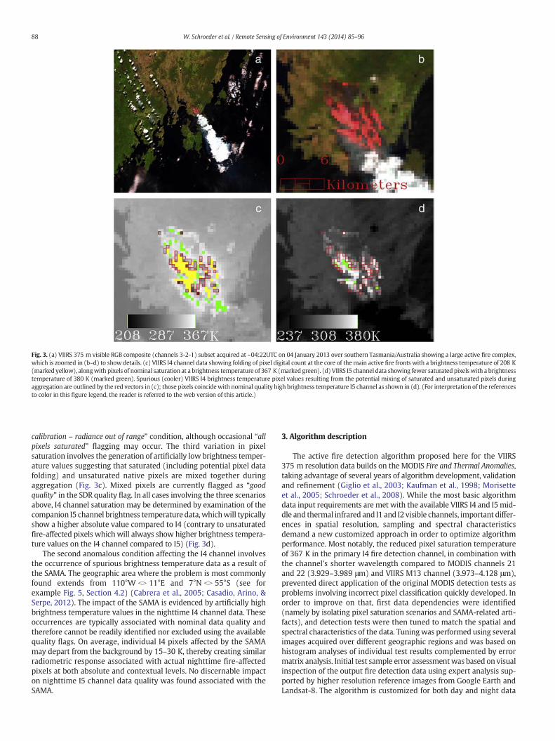
Fig. 3. (a) VIIRS 375 m visible RGB composite (channels 3-2-1) subset acquired at ~04:22UTC on 04 January 2013 over southern Tasmania/Australia showing a large active fire complex,which is zoomed in (b–d) to show details. (c) VIIRS I4 channel data showing folding of pixel digital count at the core of themain active fire fronts with a brightness temperature of 208 K(marked yellow), alongwith pixels of nominal saturation at a brightness temperature of 367 K (marked green). (d) VIIRS I5 channel data showing fewer saturated pixels with a brightnesstemperature of 380 K (marked green). Spurious (cooler) VIIRS I4 brightness temperature pixel values resulting from the potential mixing of saturated and unsaturated pixels duringaggregation are outlined by the red vectors in (c); those pixels coincidewith nominal quality high brightness temperature I5 channel as shown in (d). (For interpretation of the referencesto color in this figure legend, the reader is referred to the web version of this article.)
88 W. Schroeder et al. / Remote Sensing of Environment 143 (2014) 85–96
calibration – radiance out of range” condition, although occasional “allpixels saturated” flagging may occur. The third variation in pixelsaturation involves the generation of artificially low brightness temper-ature values suggesting that saturated (including potential pixel datafolding) and unsaturated native pixels are mixed together duringaggregation (Fig. 3c). Mixed pixels are currently flagged as “goodquality” in the SDR quality flag. In all cases involving the three scenariosabove, I4 channel saturation may be determined by examination of thecompanion I5 channel brightness temperature data,whichwill typicallyshow a higher absolute value compared to I4 (contrary to unsaturatedfire-affected pixels whichwill always show higher brightness tempera-ture values on the I4 channel compared to I5) (Fig. 3d).
The second anomalous condition affecting the I4 channel involvesthe occurrence of spurious brightness temperature data as a result ofthe SAMA. The geographic area where the problem is most commonlyfound extends from 110°W bN 11°E and 7°N bN 55°S (see forexample Fig. 5, Section 4.2) (Cabrera et al., 2005; Casadio, Arino, &Serpe, 2012). The impact of the SAMA is evidenced by artificially highbrightness temperature values in the nighttime I4 channel data. Theseoccurrences are typically associated with nominal data quality andtherefore cannot be readily identified nor excluded using the availablequality flags. On average, individual I4 pixels affected by the SAMAmay depart from the background by 15–30 K, thereby creating similarradiometric response associated with actual nighttime fire-affectedpixels at both absolute and contextual levels. No discernable impacton nighttime I5 channel data quality was found associated with theSAMA.
3. Algorithm description
The active fire detection algorithm proposed here for the VIIRS375 m resolution data builds on the MODIS Fire and Thermal Anomalies,taking advantage of several years of algorithm development, validationand refinement (Giglio et al., 2003; Kaufman et al., 1998; Morisetteet al., 2005; Schroeder et al., 2008). While the most basic algorithmdata input requirements are met with the available VIIRS I4 and I5mid-dle and thermal infrared and I1 and I2 visible channels, important differ-ences in spatial resolution, sampling and spectral characteristicsdemand a new customized approach in order to optimize algorithmperformance. Most notably, the reduced pixel saturation temperatureof 367 K in the primary I4 fire detection channel, in combination withthe channel's shorter wavelength compared to MODIS channels 21and 22 (3.929–3.989 μm) and VIIRS M13 channel (3.973–4.128 μm),prevented direct application of the original MODIS detection tests asproblems involving incorrect pixel classification quickly developed. Inorder to improve on that, first data dependencies were identified(namely by isolating pixel saturation scenarios and SAMA-related arti-facts), and detection tests were then tuned to match the spatial andspectral characteristics of the data. Tuningwas performed using severalimages acquired over different geographic regions and was based onhistogram analyses of individual test results complemented by errormatrix analysis. Initial test sample error assessmentwas based on visualinspection of the output fire detection data using expert analysis sup-ported by higher resolution reference images from Google Earth andLandsat-8. The algorithm is customized for both day and night data

89W. Schroeder et al. / Remote Sensing of Environment 143 (2014) 85–96
analyses, with the latter representing those pixels with a solar zenithangle ≥90°.
3.1. Initial data screening
3.1.1. Classification of cloud and water pixelsPixels containing optically thick clouds are classified independently as
part of the fire algorithm processing following the similar approach usedin the heritage International Geosphere-Biosphere Programme (IGBP)and MODIS fire products (Giglio et al., 2003; Stroppiana, Pinnock, &Grégoire, 2000), on which the VIIRS 750 m Active Fires ARP productalso builds upon. For daytime data, cloud pixels are classified using thefollowing tests:
BT5 b 265 KORρ1 þ ρ2 N 0:9 AND BT5 b 295 KORρ1 þ ρ2 N 0:7 AND BT5 b 285 K
where ρi is the reflectance in I-band channel i and BTi is the brightnesstemperature in I-band channel i. For nighttime data, cloud pixels areclassified based on the brightness temperature of channels I4 and I5 asfollows:
BT5 b 265 K AND BT4 b 295 K:
Adding BT4 to the nighttime cloud test improved algorithm responseto fires occurring under semi-transparent clouds (e.g., cirrus), whichcan have very cold brightness temperatures on channel I5. The firealgorithm skips all day and nighttime pixels classified as cloud-covered,and their data are excluded from the calculation of fire pixel backgroundconditions.
Water bodies were classified for daytime data using a spectral profil-ing approach using the following VIIRS I-band channel combination:
ρ1 N ρ2 N ρ3:
This test can successfully separatemostwater bodies,whereas it tendsto underperformover sediment-filledwater pixels and along some shore-lines. Also, burn scars may also be misclassified as water using the testabove although this limitation had no observable impact on the activefire detection performance. The fire algorithm processes all pixels classi-fied as water to allow for gas flare detection, although their data areexcluded from the calculation of daytime background conditions.
3.1.2. Fixed threshold testsDetection of unambiguous daytime fire-affected pixels based on a
simple fixed threshold applied to VIIRS channel I4 brightness tempera-ture data is not practical due to the spectral characteristics of that chan-nel, which could lead to numerous potential false alarms. For nighttimedata any potential ambiguity is eliminated and the following test wasadopted:
BT4N320 K AND Q F4 ¼ 0 nighttime only½ �
where QF4 is the channel I4 quality flag, whichmust show nominal dataquality.
Potential daytime and nighttime fire-affected pixels may be identi-fied through the screening of channel I4 saturated pixels in combinationwith complementary data from channels I1, I2, and I5 applied to the fol-lowing tests:
BT4 ¼ 367 K AND Q F4 ¼ 9 both day and night½ �AND
BT5N290 K AND Q F5 ¼ 0 daytime only½ � AND ρ1 þ ρ2b0:7 daytime only½ �
where QFi is the quality flag on channel i. In this case, the channel I4quality flag (decimal) value indicates complete saturation of the aggre-gated pixel value and is found concurrently with channel I5 nominalquality data. This condition coincides with the first saturation scenariodescribed above when channel I4 brightness temperature is set at thesaturation value of 367 K. In order to address the saturation scenariowhen folding of the channel I4 data is encountered, a fire pixel detectiontest is implemented using:
fΔBT45b0 both day and night½ �
AND
ðBT5N325 K AND Q F5 ¼ 0 daytime½ � ORBT5N310 K AND Q F5 ¼ 0 nighttime½ �ÞgORBT4 ¼ 208 K AND BT5N335 K nighttime½ �f g
where ΔBT45 is the channel I4 and I5 brightness temperature difference.Here, the negative difference between those two channels is indicativeof artificially cold brightness temperature on channel I4 caused bycomplete folding of the aggregated pixel value, or mixing of foldedand non-folded pixels during onboard aggregation. Typically, thiscondition is only observed at the core areas of large and very intensewildfires that are assumed to greatly exceed the effective I4 channelsaturation temperature.
All fire pixels identified using the simple thresholding tests aboveare exempted from the contextual fire detection analysis (Section 3.3),thereby reducing the overall image processing time. However, daytimefire pixels undergo additional false alarm screening described inSection 3.4, whereas night pixels occurring in the SAMA region undergoadditional verification described in Section 3.5.
3.1.3. Masking of potential background firesPotential background fire pixels are identified using daytime and
nighttime-specific tests as follows:
BT4N335 K AND ΔBT45 N30 K daytime only½ �ORBT4N300 K AND ΔBT45 N10 K nighttime only½ �
Potential background fire pixels are used below to supplement thecharacterization of background conditions for candidate fire pixels.
3.1.4. Avoiding bright fire-free targetsRadiometrically bright targets such as sand banks along riverbeds
can form small clusters of high BT4 pixel values on daytime VIIRSI-band data, some of which may be confused with active fires. In orderto avoid these areas, daytime pixels meeting the following criteria areautomatically skipped:
ρ1 þ ρ2 N 0:6 AND BT5b 285 KANDρ3N0:3 AND ρ3 N ρ2 AND ρ2 N 0:25 AND BT4 ≤ 335 K:
3.2. Candidate fire pixels
Candidate pixels are defined using a less strict set of conditions to in-clude potential background fire pixels plus other less prominent radio-metric anomalies on channel I4. The candidate pixels are thosemeetingthe following criteria:
BT4NBT4s OR ΔBT45N25 K daytime only½ �ORBT4N295 K OR ΔBT45N10 K nighttime only½ �
where BT4s is a large-area background brightness temperature referencevalue on channel I4 calculated for a 501 × 501window centered on the

90 W. Schroeder et al. / Remote Sensing of Environment 143 (2014) 85–96
pixel. This initial large-area sampling accommodates variations in back-ground conditions, adding flexibility to candidate fire pixel selection. Itis intended to improve algorithm sensitivity to fires occurring in colderhigh latitude regions, while reducing false alarm rates in lower latitudesconsisting of warmer background. The large area background samplingexcludes all pixels previously classified as cloud, water bodies, and po-tential background fire pixels, as well as any pixel with non-zero qualityflag including fill values associatedwith bowtie deletion samples. BT4s isderived using the following:
BT4M ¼ Max 325;M½ � KBT4s ¼ Min 330;BT4M½ � K
whereM is the BT4 median value calculated for the 501 × 501window.The sampling window must contain a minimum of 10 valid observa-tions or else BT4s is set to 330 K. BT4s is only derived for daytime data,allowing the candidate fire pixel brightness temperature on channel I4to vary between a minimum of 325 K to a maximum of 330 K in orderto accommodate scene-dependent changes in background conditions.Nighttime background conditions are found to be less variable,therefore we opted to use a single fixed value to define candidate firepixels at night.
3.3. Contextual analysis
The contextual analysis implemented for VIIRS 375 m fire detectionresembles the MODIS Fire Thermal Anomalies algorithm approach bysampling a dynamically assigned window size to allow optimum char-acterization of the candidate fire pixel background. In the VIIRS I-bandcase, the minimum sample size is set to an 11 × 11 element windowcentered on the candidate fire pixel. The sampling window is allowedto grow to a maximum size of 31 × 31 until at least 25% of the samplesize is composed of valid pixels, or a minimum of 10 valid pixels arefound. Similarly to the large area background sampling applied to thedaytime data, valid pixels exclude those classified as cloud, water bod-ies, potential background fire pixels, and pixels with non-zero qualityflags on any of the input bands, including those containing fill values.If the minimum number of valid pixels cannot be met, the pixel isassigned the class “unknown” indicating that the background conditioncould not be properly characterized.
Provided the minimum number of background valid pixels issatisfied, mean and mean absolute deviation values are calculated forchannels I4 BT4b;δ4b
� �, I5 BT5b;δ5b
� �, and the I4–I5 brightness tempera-
ture difference BT45b;δ45b using the background sample. In addition,mean andmean absolute deviation are calculated for channel I4 bright-ness temperature data from potential background fire pixels found
within the sampling window BT′
4; δ0
4
� �. The parameters above are
used to define a set of contextual tests that must be jointly satisfied inorder to produce a nominal confidence fire pixel detection based onthe criteria below:
Daytime :ΔBT45NΔBT45b þ 2� δ45bΔBT45NΔBT45b þ 10BT4NBT4b þ 3:5� δ4bBT5NBT5b þ δ5b−4 OR δ
0
4N5
Nighttime :ΔBT45NΔBT45b þ 3� δ45bΔBT45NΔBT45b þ 9BT4NBT4b þ 3� δ4b:
The tests above explore the distinct radiometric signature associatedwith active fires, which will typically produce a strong departure of thefire-affected pixel brightness temperature on VIIRS channel I4 com-pared to fire-free adjacent pixels. The I4 channel response is
accompanied by a relatively small variation on VIIRS channel I5 bright-ness temperature values relative to the same background. Test configu-ration is meant to avoid other image features with high channel I4brightness temperatures such as clouds, and bright and warm surfacessuch as deserts.
A complementary contextual test is applied to daytime data whenthe number of potential background fire pixels exceeds 10% of all validbackground pixels in the sampling window, and is also greater thanfour pixels. This additional test is represented as follows:
ρ2N0:15ANDBT ′4b345 AND δ
0
4b3 AND BT4NBT′4 þ 6� δ
0
4 daytime only½ �:
This test targets desert boundary areaswhere themixing of high andlow temperature land surfaces could lead to erroneous pixel classifica-tion. All candidate fire pixels meeting the test above are automaticallyrejected.
3.4. Daytime false alarm filter
Sources of potential confusion found on the daytime VIIRS I-banddata are treated independently using custom filters to reduce falsealarm rates. Areas of high solar reflection are the primary cause offalse alarms resulting in localized spikes in brightness temperature onchannel I4 off metallic rooftops in industrial parks, over large and brightsurfaces such as concrete pavement, and at water bodies over whichspecular reflection (Sun glint) may occur. In order to address thiscondition, a test is applied to all daytime nominal confidence fire pixelsdetected with the tests above using the angle θg between vectorspointing in the surface-to-satellite and specular reflection directions asin Giglio et al. (2003):
cosθg ¼ cosθv cosθs− sinθv sinθs cosϕ
where θg and θs are the view and solar zenith angles, respectively, and ϕis the relative azimuth angle. Using the expression above, pixels classi-fied as fire-affected by the previous tests are further inspected anddowngraded to the class of “glint-related false alarm” if they satisfy thefollowing condition:
θgb15�ANDρ1 þ ρ2N0:35
ORθgb25
�ANDρ1 þ ρ2N0:4:
In addition to the test above, a 3 × 3 ring is used around all remain-ing pixels classified as fire for which ΔBT45 b 30K or θg b 15° to look forlow confidence detections. Single stand-alone fire pixels (i.e., thosewithout adjacent detections) with a channel I4 brightness temperatureless than 15 K above any of the valid adjacent eight pixels forming thering are assigned a “low confidence” class; valid pixels are defined as inthe background sampling methods described above. If no valid pixelsare found, the pixel is also assigned a “low confidence” class.
3.5. Nighttime SAMA filter
The influence of the SAMA on channel I4, as described in Section 2.1,can lead to numerous false alarms in theVIIRS nighttimedata as the vastmajority of pixels affectedwillmimic the radiometric signature of activefires. In order to minimize the negative impact of that anomalousfeature on the output product, a filter based on the complementaryVIIRS M13 channel data is used to further inspect pixels classified asnominal confidence fire detections by the nighttime tests and occurringwithin the region of influence of the SAMA. The application of this addi-tional filter is restricted to stand-alone night fire pixels, as inspection ofthe first two years of VIIRS data indicated that manifestation of the

91W. Schroeder et al. / Remote Sensing of Environment 143 (2014) 85–96
SAMA on the I4 channel is typically associated with single pixel eventsscattered over large regions.
First, the M13 brightness temperature [x, y] image coordinate is de-rived from the corresponding 375 m fire pixel. Then, a simple neighbor-ing analysis is performed using a 3 × 3 ring centered on that locationcomparing the M13 brightness temperature of the target pixel withall adjacent pixels. The 375 m fire pixel is downgraded to a “lowconfidence” class if the M13 brightness temperature of the target pixelis found to be less than 1 K above all adjacent pixels. Otherwise, provid-ed the coincidentM13brightness temperature is also indicative of a heatanomaly, the pixel is confirmed as a nominal confidence fire detection.
4. Results
4.1. Theoretical minimum detectable fire
We assessed the theoretical performance of the fire detection algo-rithm by simulating different fire scenarios applied to actual VIIRS375 m global imagery. Fires were simulated assuming areas rangingfrom 2 to 250 m2, and temperatures ranging from 400 to 1200 K. Fireradiances were derived at 2 m2 and 10 K intervals for both I4 and I5channels using the instrument's spectral response functions, andassuming blackbody emission. A total of 10 daytime and 10 nighttimeVIIRS 5-min orbit segments acquired duringAugust 2013were random-ly selected covering different geographic areas, including low and highlatitude regions, with variable levels of fire activity. For every image,we selected 10 pixels distributed along nadir and apart from eachother, and when possible, near areas of fire activity in order to bestrepresent regional fire-prone conditions. Simulated fire radiances andactual background radiances were area-weighted to provide realisticBT4 and BT5 pixel values representative of actual observation condi-tions. The new VIIRS 375 m active fire detection algorithm was thenapplied to the imagery data containing a simulated active fire pixelsurrounded by genuinely observed background pixels.
Fig. 4 shows the 50% probability of detection curves derived for thedaytime and nighttime fire algorithms applied to the global data sample.Improved nighttime performance resulted from the more homogeneousbackground conditions, significantly enhancing the algorithm's responseto relatively small heat sources. An experimental fire consisting of a1.25 m radius circular bonfire burning at ~1000 K corroborated thenight fire detection curve. The burn was conducted on 08 July 2013near Rio de Janeiro, Brazil (43°00′00″W 22°23′36.6″S), coincident withthe VIIRS overpass at 1:23 am local time. The fire was imaged by VIIRSat a 32.7° scan angle producing a +10 K increment over the I4 channelbackground, consequently satisfying all contextual tests in the nighttimefire algorithm. Meanwhile, daytime algorithm performance is subjectedto the solar component, which introduces larger background variations
Fig. 4. Theoretical 50% probability offire detection curves derived for VIIRS 375 m day andnighttime algorithms as a function of fire area and temperature.
and potential ambiguity involving highly reflective fire-free surfaces onchannel I4. Consequently, the simulated daytime probability of detectionwas found to be lower compared to the same heat sources introduced inthe nighttime data.
Despite the differences between day and nighttime algorithmtheoretical fire detection probability curves indicated here, actual prod-uct performance suggests that diurnal variations in fire behavior couldhelp reduce that contrast. For example, larger and/or more intensebiomass burning, typical of VIIRS early afternoon overpass timeswhen dryer and warmer fuel and weather conditions prevail (Beck,Alexander, Harvey, & Beaver, 2002; Smith et al., 2013), should favor sep-aration of active fire pixels frombackground. Conversely, smaller and/orcooler night fires could partially offset the improved separation offire-affected pixels from a backgroundwith no solar component. Conse-quently, we expect this to lead tomore uniformdetection rates for samesize fires burning during day and night observations (see forexample Figs. 8 and 9, Sections 4.2.1 and 4.2.2).
4.2. Global fire detection performance
The performance of the 375 m active fire detection algorithm isdemonstrated here for 30 days of global VIIRS data covering 1–30 Au-gust 2013. The algorithm was applied to both day and nighttime data,and the results compared to VIIRS 750 m Active Fires ARP (IDPS ver-sion) and Aqua/MODIS 1 km (MYD14) active fire detection products.
Fig. 5 shows the spatial distribution of daytime and nighttime fire de-tections produced by the VIIRS 375 m fire algorithm, plus low confidencedaytime pixels potentially associated with bright fire-free land surfacefeatures and low confidence nighttime pixels identified across theSAMA region. On average, ~59,000 daytime and ~15,000 nighttime nom-inal confidencefire pixelswere detected daily during the period sampled.
The application of the special filter to separate lower confidencenighttime pixels was effective in eliminating the vast majority of detec-tions induced by the SAMA. However, on average 3 nighttime pixels ofnominal confidence were detected daily over suspicious locations(e.g., pixels over open ocean away from known heat sources). Lack ofappropriate reference data prevented further inspection of those isolat-ed pixels; these cases represented 1% of all low confidence nighttimepixels detected over ocean in the SAMA region. Application of the night-time false alarmfilter across the SAMA regionwas also found to produceoccasional omission errors for small and low intensity fires without ameasurable heat signature on channel M13. Examples of confirmedomission errors induced by the SAMA filter were observed overknown inland gas flares. Overall, commission and omission errorsacross the SAMA region were found to be reduced based on visualimage inspection; further investigation using quality reference data isrequired in order to quantitatively estimate those potential errors. Thenumber of low confidence fire pixels in the SAMA region accountedfor approximately 5% of all nighttime fire pixels detected globally.
Daytime commission errors were typically found over bright landsurfaces in areas of Sun glint. Those pixelswere predominantly associat-ed with reflective rooftops on large industrial buildings. Commissionerror rates were estimated for the nominal confidence daytime firepixels by sampling single orbit data subsets distributed over 12 distinct10° × 10° regions around the globe (Fig. 6). The data sample covered awide range of land surface conditions, including areaswith different fireregimes and subject to different levels of urban development. Areas ineastern China were particularly prone to produce false alarms showinga 1.2% commission error rate. Those cases were ambiguous to low con-fidence daytime pixels and were often observed over large industrialbuildings containing highly reflective rooftops. In those areas the build-ingmaterials and the landscape configuration,which is characterized bylarge industrial parks surrounded by cooler background, were found toaugment the ambiguity between fire-free and fire-affected pixels. Thedaytime commission error rate for nominal confidence detections pre-dominantly associated with urban false alarms was assessed using
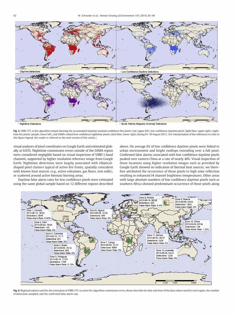
Fig. 5.VIIRS 375 m fire algorithmoutput showing the accumulated daytime nominal confidence fire pixels (red; upper left), low confidence daytime pixels (light blue; upper right), night-time fire pixels (purple; lower left), and SAMA-related low confidence nighttime pixels (dark blue; lower right) during 01–30 August 2013. (For interpretation of the references to color inthis figure legend, the reader is referred to the web version of this article.)
92 W. Schroeder et al. / Remote Sensing of Environment 143 (2014) 85–96
visual analyses of pixel coordinates onGoogle Earth and estimated glob-ally at 0.03%. Nighttime commission errors outside of the SAMA regionwere considered negligible based on visual inspection of VIIRS I-bandchannels, supported by higher resolution reference image from GoogleEarth. Nighttime detections were largely associated with elliptical-shaped pixel clusters typical of active fire fronts, spatially coincidentwith known heat sources (e.g., active volcanoes, gas flares, iron mills),or scattered around active biomass burning areas.
Daytime false alarm rates for low confidence pixels were estimatedusing the same global sample based on 12 different regions described
Fig. 6.Regional subsets used for the estimation of VIIRS 375 mactivefire algorithmcommissionof detections sampled, and the confirmed false alarm rate.
above. On average 6% of low confidence daytime pixels were linked tourban environment and bright rooftops extending over a full pixel.Confirmed false alarms associated with low confidence daytime pixelspeaked over eastern China at a rate of nearly 40%. Visual inspection ofthose locations using higher resolution images such as provided byGoogle Earth showed no indication of thermal heat sources; we there-fore attributed the occurrence of those pixels to high solar reflectionresulting in enhanced I4 channel brightness temperatures. Other areaswith large absolute numbers of low confidence daytime pixels such assouthern Africa showed predominant occurrence of those pixels along
errors. Boxes describe the date and time of the data subset used for each region, the number

93W. Schroeder et al. / Remote Sensing of Environment 143 (2014) 85–96
the edge of fire pixel clusters of nominal confidence; therefore we asso-ciated those cases with lower intensity sub-pixel fire activity. Daytimelow confidence fire pixels accounted for approximately 11% of alldaytime detections produced globally.
Nominal saturation on channel I4 impacted approximately 8% of alldaytime fire pixels detected, compared to 0.02% on channel I5. Night-time saturation rateswere equivalent to 1% on channel I4 and negligibleon channel I5. Folding of the I4 digital value occurred for 0.2% of the firepixels detected, whereas no pixel folding was identified on channel I5.Additionally, suspicious brightness temperature values on channel I4were found for 0.5% of the daytime and0.04% of the nighttimefire pixelsin associationwith potentialmixing of saturated and unsaturated nativepixel radiances during onboard data aggregation. As described above,nominal pixel saturation and folding episodes were all accompaniedby SDR flags indicating poor data quality. Meanwhile, the suspiciousbrightness temperature values involving potential mixing of saturatedand unsaturated pixels were all accompanied by nominal SDR qualitydata flags. Due to the non-negligible rate of pixel saturation on channelI4 and the potential idiosyncrasies involving the SDR quality flags, weopted to defer the retrieval of sub-pixel fire characteristics such asFRP, size and temperature to future studies pending proper investiga-tion of the complementary use of the dual-gain M13 channel data insupport of those analyses.
4.2.1. Comparison with VIIRS 750 m Active Fires ARPThe VIIRS 375 m active fire detection data were compared to the
operational VIIRS 750 m Active Fires ARP detection data generated byIDPS in order to assess the overall consistency between products.VIIRS 375 m and 750 m data are acquired simultaneously, and spatially
Fig. 7. Frequency of VIIRS 375 m fire pixels with (dashed line) and without (solid line) coincide2013. The horizontal axis indicates the number of VIIRS 375 m fire detections contained withindetected using VIIRS 375 m and 750 m daytime (c) and nighttime (d) data.
co-registered (one 750 m pixel overlaps with four [2 × 2] 375 mpixels). Day and nighttime results were analyzed separately, as both al-gorithm and observation conditions differ in each case. Overall, VIIRS375 m fire algorithm showed a three-fold increase in the absolute num-ber of daytime fire pixels detected compared to the 750 m Active FiresARP product, and a staggering 25-fold increase in the absolute numberof nighttime fire pixels detected compared to the 750 m fire product.The number of coincident daytime detections produced by both datasets (i.e., one 750 m Active Fires ARP fire pixel with a minimum ofone and a maximum of four overlapping 375 m nominal confidencefire pixel; Fig. 7a–b, dashed lines) accounted for 43% and 83% ofthe 375 m and 750 m fire pixels, respectively. Further considerationof 375 m low confidence daytime fire pixels helped increase the rateof coincident detections to 90% of the 750 m fire pixels. Meanwhile,the number of coincident nighttime detections accounted for 10% and98% of the 375 m and 750 m fire pixels produced, respectively. Thesestatistics reflect a significantly higher rate of fire detection using the375 m data at night compared to the 750 m product (Fig. 7a–b; solidlines).
Differences in day and nighttime performance observed for the twoVIIRS fire detection data sets also applied to spatially coincident clustersof contiguous fire pixels. Fig. 7c–d shows density plots of spatiallycoincident fire pixel clusters detected by the 375 m and 750 m firealgorithms, ranging in size from 1 to 10 contiguous pixels in eachcase. Coincident fire pixel clusters in the nighttime data were largelyskewed towards the lower part of the plot area, indicating the occur-rence ofmultiple contiguous 375 m fire pixels overlappingwith smaller750 m pixel clusters often containing less than two contiguous pixelelements.
nt 750 m active fire detection for daytime (a) and nighttime (b) data during 1–30 Augusteach 750 m pixel footprint. Density plot showing the size of coincident fire pixel clusters

Fig. 8. VIIRS 375 m and 750 m fire detection data acquired at 14:28 h PDT on 06 August 2013 and at 2:50 h PDT on 07 August 2013 over the Power Fire in California. USDA-Forest ServiceNIROPS airborne data acquired at 21:36 h PDT on 06 August 2013 shows the mapped fire perimeter as well as the areas showing intense heat.
94 W. Schroeder et al. / Remote Sensing of Environment 143 (2014) 85–96
The occurrence of lower intensity fires at nightmay help explain theresults above, since those fires could fall below the detection limit of the750 m product as suggested by the flat response of the 750 m productto smaller 375 m fire pixel clusters (Fig. 7b). Meanwhile, the occurrenceof large 375 m fire pixel clusters with 1–2 750 m coincident pixelssuggests potential omission errors in the IDPS product. The VIIRS750 m Active Fires ARP product generated by IDPS is a replica of theCollection 4 MODIS Fire and Thermal Anomalies algorithm, modified toaccept VIIRS data format. Consequently, tuning of the 750 m fire algo-rithm processed by IDPS to the VIIRS sensor-specific characteristicsmay be required.
The relative performance of the 375 m and 750 m fire detectionalgorithms was assessed using reference airborne fire data acquired bythe U.S. Department of Agriculture – Forest Service National InfraredOperations (NIROPS) over wildfires in the United States in 2012 and2013. Fig. 8 shows VIIRS 375 m and 750 m active fire detection clustersdetected approximately 7 h before and 5 h after the NIROPSmapping ofthe Power Fire in California around 21:36 h PDT on 06 August 2013. Thefirst VIIRS overpass represents the daytime data acquisition, whereasthe second overpass coincides with the nighttime data approximately12 h later. VIIRS 375 m detections are color-coded using the middle-infrared channel I4 brightness temperature data in order to provide aproxy for fire intensity across the complex at the moment of overpass.Differences between day and night data may be due to changes in firebehavior and background conditions as well as a result of the solarcontribution in the middle-infrared channel. The daytime VIIRS fire
Fig. 9. Daily fire spread mapped by 1 km Terra/MODIS (left), 375 m VIIRS (center), and 1 km(−32.7°lat, −52.55°lon). The data cover the period beginning on 26 March 2013 (Julian day31 March 2013. The white vector outline represents the burned area mapped using the 30 m L
detectionsderived from the375 mand750 mdata showed good spatialagreement, and were well aligned with the underlying NIROPS fire pe-rimeter and intense heat areas. The nighttime VIIRS 375 m data showeda small noticeable spatial progress of the 375 m fire cluster moving inthe northeast direction, while maintaining good overall spatial agree-ment with NIROPS. The nighttime 750 m fire cluster was reduced tothe northeastern part of the complex, omitting the cooler southwesternportion of the fire complex.
4.2.2. Comparison with MODISFor more than a decade the Fire and Thermal Anomalies product has
been among themost commonly used data set of theMODIS land prod-uct suite, serving both fire managers and the fire science community.The new VIIRS 750 m Active Fires EDR data will provide continuity tothat invaluable data set into the next decade, delivering similar fire de-tection and characterization information to the user community. TheVIIRS 375 m fire detection data complement the 750 m fire product,and could represent a significant improvement over the currentMODIS 1 km data providing spatially refined fire information. To illus-trate the potential qualitative gain in performance of the new VIIRS375 m data compared to current MODIS 1 km product we analyzed afire complex in southern Brazil. That fire burned for several days inMarch of 2013 and was imaged by VIIRS and MODIS onboard TerraandAqua (Fig. 9). Thefire data derived from sequential VIIRS 375 m im-ages showed spatially consistent day and night fire detection clusters,and was estimated to spread at a rate of 58 m/h. Comparatively, the
Aqua/MODIS (right) data for a wildfire at the Taim Ecological Reserve in southern Brazil85) and ending at the approximate time of the Landsat-7 data acquired at 13:15UTC onandsat-7 data.

95W. Schroeder et al. / Remote Sensing of Environment 143 (2014) 85–96
MODIS 1 km fire detection data showedmuch less coherent fire spreadinformation as a result of partial omission of the fire complex, as well asdue to limited coverage provided byMODIS data at that latitude. Conse-quently, fire spread could not be properly estimated using MODIS data.Additionally, the VIIRS active fire pixels provide significantly improvedspatial agreement with the available burned area perimeter digitizedusing Landsat-7 data acquired on 31 March 2013.
4.2.3. Comparison with Landsat-8Previous satellite fire remote sensing validation studies used
both coincident and near-coincident Advanced Spaceborne ThermalEmission and Reflection Radiometer (ASTER) and Landsat-5 and 7data to quantify commission and omission errors for MODIS andGeostationary Operational Environmental Satellite (GOES) active fireproducts (Giglio et al., 2008; Morisette et al., 2005; Schroeder et al.,2008). In the case of VIIRS and Landsat-8 sensor data, the average 3 hseparation between same-day image acquisition times prevents
Fig. 10. Landsat-8 image subsets acquired on 24 July (upper left) and 09 August (upper right) 20shown are the VIIRS 375 m fire detection data (yellow vectors) acquired approximately 75 mindetection pixels during the time interval separating the two Landsat-8 acquisition dates, colorperimeter mapped using dNBR applied to Landsat-8 data. (For interpretation of the references
application of the paired data sets for quantitative error analyses, as ar-tifacts associated with short-term variations in fire behavior can be in-troduced (Csiszar & Schroeder, 2008). However, Landsat-8 imagesmay still be used as a reference data set in support of qualitative assess-ment of the VIIRS 375 m fire detection data allowing for visual interpre-tation of areas of active biomass burning.
Fig. 10 shows an active fire region in Melville Island/Australia im-aged by Landsat-8 on 24 July and 09 August 2013. The VIIRS imagesfor those two dates were acquired approximately 75 min after theLandsat-8 overpass. Areas showing active fire fronts could be separatedon the Landsat-8 data using a fire detection algorithm based on thevisible and shortwave infrared channels 5 and 7, similar to Schroederet al. (2008). Burn scars can also be identified adjacent to the activefires. Visual analysis of the Landsat images shows the fire-affected areaexpanding outward in all directions, and particularly to the east andwest of the large fire fronts detected on 24 July 2013. Overall, the instan-taneous VIIRS 375 m fire detection data captured most of the near-
13 over theMelville Island inAustralia. Activefire fronts on Landsat-8 aremarked red. Alsoafter the Landsat-8 images. The lower left panel shows the accumulated VIIRS 375 m fire
-coded to indicate the calendar day of detection. The black vector shows the burned areato color in this figure legend, the reader is referred to the web version of this article.)

96 W. Schroeder et al. / Remote Sensing of Environment 143 (2014) 85–96
coincident Landsat-8 active fire perimeter. Small differences could beidentified and we assumed that thosewere caused by short-term varia-tions in fire behavior, and due to differences in detection performancebetween the two data sets. The VIIRS fire detections accumulated overthe period separating the acquisition dates of the two Landsat-8 scenesshowed good spatial overlap with the 30 m resolution burned areamapped using differenced Normalized Burned Ratio (dNBR), providingfurther temporal informationon thefire growthduring that 16-dayperiod.
5. Conclusions
In this paper we introduced the use of the new 375 m VIIRS sensordata in support of active fire detection using a contextual algorithmbuilt on the heritage MODIS Fire and Thermal Anomalies product. Differ-ences in VIIRS I-band spatial and spectral resolution were all addressedwith the new algorithm. The new data set provides significantly refinedspatial fire information, improving upon the current line of coarserspatial resolution satellite active fire detection products. The lower367 K pixel saturation temperature in the middle-infrared I4 channel,combinedwith the pixel's smaller ground footprint, resulted in frequentsaturation of fire-affected pixels. While the impact on active fire detec-tion performance could beminimized, this condition created additionalchallenges to the retrieval of sub-pixel fire characterization parameterssuch as FRP, size and temperature. Alternatively, use of the 750 m dual-gain M13 channel data, which saturates at 634 K, could help comple-ment the 375 m fire detection data providing unsaturated input datafor the retrieval of sub-pixel fire characteristics; this is the subject of on-going investigation.
The VIIRS improved spatial sampling, which eliminates coveragegaps over lower latitudes and minimizes pixel size increase with scanangle, provided consistent daily fire mapping performance of fires last-ing several days. Our initial data quality assessment indicated high levelof agreement between VIIRS 375 m fire detection data and near-coincident higher resolution airborne and Landsat-8 reference datasets. The classification of pixels into two main classes, namely nominaland low confidence groups, helped separate confirmed fire-affectedpixels from ambiguous pixels more likely associated with false alarmsand marginal burning.
The availability of spatially-refined active fire perimeter derivedfrom 12 h VIIRS 375 m data provides new opportunities for using satel-litefire information in support offire tacticalmapping andmodeling ap-plications. New applications building on these data have successfullydemonstrated the assimilation of fire perimeter information derivedfrom VIIRS 375 m fire data into higher resolution fire behavior models(Coen & Schroeder, 2013). Similar new applications are likely to follow.
Future development of the VIIRS 375 m algorithm described hereshall explore the complementary use of the 750 mdata, leading to a po-tential hybrid algorithm based on both sets of data. The current 375 mfire algorithm is intended for implementation as part of the Internation-al Polar Orbiter Processing Package (IPOPP) in order to serve thebroader international community. Presently, routine data covering theConterminous United States can be accessed at the following URL:http://viirsfire.geog.umd.edu/data.html.
Acknowledgments
This study was supported by the NASA Terrestrial Ecology andApplied Sciences Programs through the following research grants:NNX12AQ87G and NNH11AS03I. We are thankful for USDA's RemoteSensing Applications Center (Mr. Brad Quayle), National Infrared Oper-ations (Mr. Thomas Mellin), and Pacific Southwest Research Station(Dr. Philip Riggan) for supporting initial data quality assessment in theUnited States.
References
Beck, J. A., Alexander, M. E., Harvey, S. D., & Beaver, A. K. (2002). Forecasting diurnalvariations in fire intensity to enhance wildland firefighter safety. InternationalJournal of Wildland Fire, 11, 173–182.
Cabrera, J., Cyamukungu, M., Stauning, P., Leonov, A., Leleux, P., Lemaire, J., et al. (2005).Fluxes of energetic protons and electrons measured on board the Oersted satellite.Annales Geophysicae, 23, 2,975–2,982.
Cao, C., DeLuccia, F., Xiong, X., Wolfe, R., &Weng, F. (2013). Early On-orbit Performance ofthe Visible Infrared Imaging Radiometer Suite (VIIRS) onboard the Suomi NationalPolar-orbiting Partnership (S-NPP) Satellite. IEEE Transactions on Geoscience andRemote Sensing. http://dx.doi.org/10.1109/TGRS.2013.2247768.
Casadio, S., Arino, O., & Serpe, D. (2012). Gas flaring monitoring from space using ATSRinstrument series. Remote Sensing of Environment, 116, 239–249.
Coen, J., & Schroeder, W. (2013). Use of spatially refined satellite remote sensingfire detection data to initialize and evaluate coupled weather-wildfire growthmodel simulations. Geophysical Research Letters. http://dx.doi.org/10.1002/2013GL057868.
Csiszar, I., & Schroeder, W. (2008). Short-term observations of the temporal developmentof active fires from consecutive same-day ETM+ and ASTER imagery in the Amazon:Implications for active fire product validation. IEEE Journal of Selected Topics in AppliedEarth Observations and Remote Sensing, 1(4), 248–253.
Csiszar, I., Schroeder, W., Giglio, L., Ellicott, E., Wind, B., Vadrevu, K. P., et al. (2013).Active fires from the Suomi NPP Visible Infrared Radiometer Suite: Productstatus and first evaluation results. Journal of Geophysical Research. http://dx.doi.org/10.1002/2013JD020453 (in press)..
Davies, D. K., Ilavajhala, S., Wong, M. M., & Justice, C. O. (2009). Fire information forresource management system: Archiving and distributing MODIS active fire data.IEEE Transactions on Geoscience and Remote Sensing, 47(1), 72–79.
Elvidge, C. D., Kroehl, H. W., Kihn, E. A., Baugh, K. E., Davis, E. R., & Hao, W. M. (1996). Al-gorithm for the retrieval of fire pixels from DMSP operational linescan system data.Biomass burning and global change: Remote sensing, modeling and inventorydevelopment, and biomass burning in Africa, 1. (pp. 73–85), 73–85.
Elvidge, C. D., Zhizhin, M., Hsu, F. -C, & Baugh, K. E. (2013). VIIRS nightfire: Satellite py-rometry at night. Remote Sensing, 5, 4,423–4,449.
Flasse, S. P., & Ceccato, P. (1996). A contextual algorithm for AVHRR fire detection.International Journal of Remote Sensing, 17(2), 419–424.
Giglio, L., Csiszar, I., Restas, Á., Morisette, J. T., Schroeder, W., Morton, D., et al.(2008). Active fire detection and characterization with the advancedspaceborne thermal emission and reflection radiometer (ASTER). RemoteSensing of Environment, 112, 3055–3063.
Giglio, L., Descloitres, J., Justice, C. O., & Kaufman, Y. J. (2003). An enhanced contextual firedetection algorithm for MODIS. Remote Sensing of Environment, 87, 273–282.
Giglio, L., Loboda, T., Roy, D. P., Quayle, B., & Justice, C. O. (2009). An active-fire basedburned area mapping algorithm for the MODIS sensor. Remote Sensing ofEnvironment, 113(2), 408–420.
Hillger, D., Kopp, T., Lee, T., Lindsey, D., Seaman, C., Miller, S., et al. (2013). First-lightimagery from Suomi NPP VIIRS. Bulletin of the American Meteorological Society.http://dx.doi.org/10.1175/BAMS-D-12-00097.1.
Ichoku, C., Giglio, L., Wooster, M. J., & Remer, L. A. (2008). Global characterization ofbiomass-burning patterns using satellite measurements of fire radiative energy.Remote Sensing of Environment, 112, 2950–2962.
Joint Polar Satellite System (JPSS) (2013). Common data format control book – external(CDFCB-X) – volume III block 1.2.3 (effective date: July 2, 2013)– SDR/TDR formats,document number: 474-00001-03-B0123. http://npp.gsfc.science.sciencedocuments
Justice, C. O., Giglio, L., Korontzi, S., Owens, J., Morisette, J. T., Roy, D., et al. (2002). TheMODIS fire products. Remote Sensing of Environment, 83, 244–262.
Justice, C. O., Román, M.O., Csiszar, I., Vermote, E. F., Wolfe, R. E., Hook, S. J., et al. (2013).Land and cryosphere products from Suomi NPP VIIRS: Overview and status. Journal ofGeophysical Research, [Atmospheres], 118. http://dx.doi.org/10.1002/jgrd.50771.
Kaufman, Y. J., Justice, C. O., Flynn, L. P., Kendall, J.D., Prins, E. M., Giglio, L., et al. (1998).Potential global fire monitoring from EOS-MODIS. Journal of Geophysical Research,103(D24), 32,215–32,238.
Morisette, J. T., Giglio, L., Csiszar, I., & Justice, C. O. (2005). Validation of the MODIS activefire over Southern Africa with ASTER data. International Journal of Remote Sensing,26(19), 4239–4264.
Roy, D., Boschetti, L., Justice, C. O., & Ju, J. (2008). The collection 5 MODIS burned areaproduct—Global evaluation by comparison with the MODIS active fire product.Remote Sensing of Environment, 112(9), 3690–3707.
Schroeder, W., Prins, E., Giglio, L., Csiszar, I., Schmidt, C., Morisette, J. T., et al. (2008). Valida-tion of GOES and MODIS active fire detection products using ASTER and ETM + data.Remote Sensing of Environment, 112, 2711–2726.
Smith, A. M. S., Tinkham,W. T., Roy, D. P., Boschetti, L., Kremens, R. L., Kumar, S. S., Sparks,A. M., & Falkowski, M. J. (2013). Quantification of fuel moisture effects on biomassconsumed derived from fire radiative energy retrievals. Geophysical Research Letters,40. http://dx.doi.org/10.1002/2013GL058232.
Stroppiana, D., Pinnock, S., & Grégoire, J. -M. (2000). The Global Fire Product: Daily fireoccurrence from April 1992 to December 1993 derived from NOAA AVHRR data.International Journal of Remote Sensing, 21, 1279–1288.
Wolfe, R. E., Lin, G., Nishihama, M., Tewari, K. P., Tilton, J. C., & Isaacman, A.R. (2013). SuomiNPP VIIRS prelaunch and on-orbit geometric calibration and characterization. Journal ofGeophysical Research, [Atmospheres], 118, 11,508–11,521. http://dx.doi.org/10.1002/jgrd.50873.


![[REMOTE SENSING] 3-PM Remote Sensing](https://static.fdocuments.in/doc/165x107/61f2bbb282fa78206228d9e2/remote-sensing-3-pm-remote-sensing.jpg)


