
Remote Sensing Microwave Remote Sensing. 1. Passive Microwave Sensors ► Microwave emission is...
32
Remote Sensing Remote Sensing Microwave Remote Sensing Microwave Remote Sensing
-
Upload
bruno-bruce -
Category
Documents
-
view
275 -
download
3
Transcript of Remote Sensing Microwave Remote Sensing. 1. Passive Microwave Sensors ► Microwave emission is...

Remote SensingRemote Sensing
Microwave Remote SensingMicrowave Remote Sensing

1. Passive Microwave Sensors1. Passive Microwave Sensors► Microwave emission is related to Microwave emission is related to
temperature and emissivity temperature and emissivity ►Microwave radiometers are sensitive to Microwave radiometers are sensitive to
= 0.1mm - 30cm = 0.1mm - 30cm ► The interpretation requires knowledge of the The interpretation requires knowledge of the
system, the atmosphere, and the thermal system, the atmosphere, and the thermal property of the objectsproperty of the objects

2. Active Microwave Sensors - 2. Active Microwave Sensors - RadarsRadars
RADAR: RAdio Detection And Ranging RADAR: RAdio Detection And Ranging

2. Active Microwave Sensors - 2. Active Microwave Sensors - RadarsRadars
► Transmitter: transmits repetitive pulse of Transmitter: transmits repetitive pulse of microwave energy microwave energy
► Receiver: receives the reflected signal Receiver: receives the reflected signal through antenna and filters and amplifies through antenna and filters and amplifies the signalthe signal

2. Active Microwave Sensors - 2. Active Microwave Sensors - RadarsRadars
► Antenna array: transmits a narrow beam of Antenna array: transmits a narrow beam of microwave energy microwave energy
► Recorder: records and displays the signal as Recorder: records and displays the signal as an imagean image
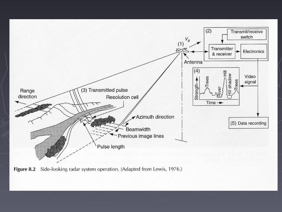

3. Side-Looking Airborne Radar 3. Side-Looking Airborne Radar (SLAR)(SLAR)
► RangingRanging
- distance from the antenna to the features - distance from the antenna to the features can be calculated by measuring the time can be calculated by measuring the time delay between the time when a signal is delay between the time when a signal is transmitted to the time its echo is received transmitted to the time its echo is received
► Detecting frequency and polarization shifts Detecting frequency and polarization shifts
- by comparing the transmitted signal of - by comparing the transmitted signal of known properties to the received signalknown properties to the received signal


3. Side-Looking Airborne Radar 3. Side-Looking Airborne Radar (SLAR)(SLAR)
► The "all weather" capability: The "all weather" capability:
- the - the used by SLAR is long enough to used by SLAR is long enough to penetrate clouds and light rain, e.g. penetrate clouds and light rain, e.g. applications in tropical area applications in tropical area
- SLAR systems are independent from solar - SLAR systems are independent from solar illumination, which makes night missions illumination, which makes night missions possible possible

3. Side-Looking Airborne Radar 3. Side-Looking Airborne Radar (SLAR)(SLAR)
► Spatial resolution Spatial resolution
- spatial scale at 1:100,000, between - spatial scale at 1:100,000, between Landsat and air photo Landsat and air photo
- spectral information different from other - spectral information different from other sensor systemssensor systems

4. Geometry of the Radar Image4. Geometry of the Radar Image
► Radar shadow Radar shadow
► Radar layoverRadar layover
► Radar foreshortening Radar foreshortening
4. Geometry of the Radar Image4. Geometry of the Radar Image
► Depression angle Depression angle
► Far, mid, and near-range portion of a radar Far, mid, and near-range portion of a radar imageimage
► Radar shadow, more severe in the far range Radar shadow, more severe in the far range

4. Geometry of the Radar Image4. Geometry of the Radar Image

4. Geometry of the Radar Image4. Geometry of the Radar Image
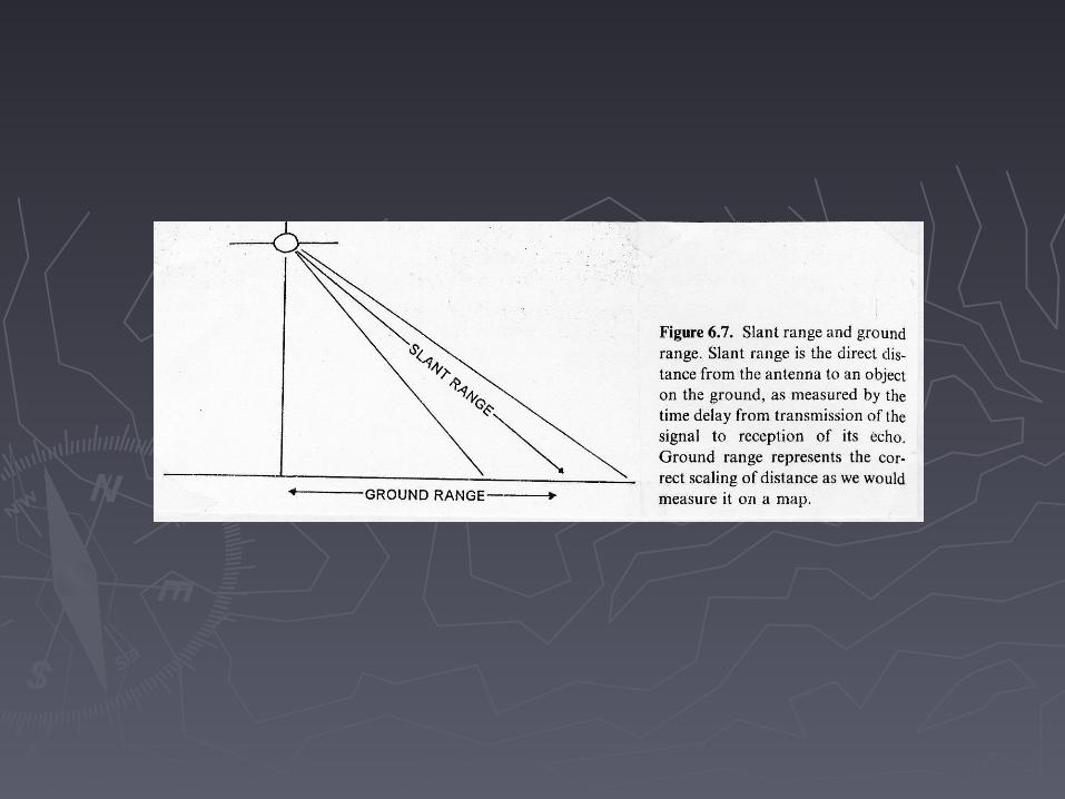
► Slant range distanceSlant range distance
- direct distance from the antenna to an - direct distance from the antenna to an object on the ground measured by time object on the ground measured by time delay delay
► Ground range distance Ground range distance
- distance of correct scaling as we would - distance of correct scaling as we would measure on a map measure on a map

4. Geometry of the Radar Image4. Geometry of the Radar Image
► Geometric errors Geometric errors
- because radars collect information in slant - because radars collect information in slant range distance range distance
► Radar layoverRadar layover► Radar foreshorteningRadar foreshortening

4. Geometry of the Radar Image4. Geometry of the Radar Image
► Radar layover Radar layover
- the top of a tall object appears closer to - the top of a tall object appears closer to the antenna than its base the antenna than its base
- the antenna receives the echo of the top - the antenna receives the echo of the top before the base before the base
- it is more severe in the near range- it is more severe in the near range

Radar LayoverRadar Layover

Radar LayoverRadar Layover

4. Geometry of the Radar Image4. Geometry of the Radar Image
► Radar foreshortening Radar foreshortening
- with modest or high relief in the mid or far - with modest or high relief in the mid or far range portion range portion
- features maintain relative position but - features maintain relative position but incorrect distance causing near range slope incorrect distance causing near range slope appear steeper and far range slope gentler appear steeper and far range slope gentler

Radar ForeshorteningRadar Foreshortening


5. Resolutions5. Resolutions
► Slant range resolutionSlant range resolution► Ground range resolutionGround range resolution► Azimuthal resolution Azimuthal resolution

5. Resolutions5. Resolutions
► Two determinant parameters: pulse length Two determinant parameters: pulse length and antenna beam width and antenna beam width
- the pulse length dictates the spatial - the pulse length dictates the spatial resolution in the direction of energy resolution in the direction of energy propagation propagation
- the width of the antenna beam determines - the width of the antenna beam determines the resolution cell size in the flight directionthe resolution cell size in the flight direction


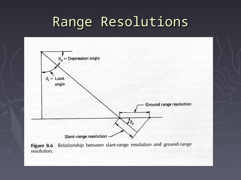
Range Resolutions (along track)Range Resolutions (along track)
► Slant-range resolution (Sr) is consistentSlant-range resolution (Sr) is consistent
- equal to half the transmitted pulse length - equal to half the transmitted pulse length PL/2 PL/2
► Ground-range resolution (Rr) changes with Ground-range resolution (Rr) changes with distance from the aircraft distance from the aircraft
- inversely related to the cosine of - inversely related to the cosine of depression angle depression angle
Rr = slant range resolution/cosRr = slant range resolution/cosdd, ,
d d - depression angle- depression angle
Range ResolutionsRange Resolutions

Azimuth Resolution (cross track)Azimuth Resolution (cross track)
► is determined by the angular beam width is determined by the angular beam width and slant range Sr and slant range Sr
- while beam width - while beam width is inversely related to is inversely related to antenna length AL antenna length AL
RRaa = Sr · = Sr ·, , = = /AL, /AL, -pulse wavelength -pulse wavelength
- near range portion has finer resolution - near range portion has finer resolution than the far range than the far range


ReadingsReadings
► Chapter 8Chapter 8


![Technical Seminar Presentation-2004 MICROWAVE REMOTE SENSING Kishore Kumar ParidaEC200117313 [1] Microwave Remote Sensing (MRS) Presented by Kishore Kumar.](https://static.fdocuments.in/doc/165x107/56649eb35503460f94bba821/technical-seminar-presentation-2004-microwave-remote-sensing-kishore-kumar.jpg)

