Remnants of a Golden Era — Palmer River Goldfield 1986205733/s00855804_1987_13... · John Hay is...
10
Remnants of a Golden Era — Palmer River Goldfield 1986 Dedicated to the memory of the late Sam Elliott by John Hay Presented to a meeting of the Society 28 August 1986 Aptly described as "the most remote and harshest field worked by early Australian diggers", the Far North Queensland Palmer River Goldfield still retains its vast and inaccessible appearance. The scene that first confronted the diggers over a hundred years ago seems bare- ly unchanged, yet the remnants of that era scattered throughout the bushland form a visual legacy to the golden days of the Palmer. A small portion of our heritage is being preserved through individuals like the late Sam EUiott, and organisations such as the Palmer River Historic Preservation Society. Discovered in 1872 by the renowned explorer William Hann, the mighty Palmer played host to the ensuing "gold-rush" that was to see an infiltration of diggers into every creek, gully, and river bed on the field. Three aspects of the Palmer history gave rise to the visual artifacts that remain to-day. The first was the invasion by the European and Chinese diggers, who formed the array of alluvial workings and camp sites. The second was the need to establish routes in the form of dray roads and pack trails for transit through the unchartered bushland, and the third was the inevitable advent of reef mining. Gold was won quickly on the Palmer in 1873 and 1874, and dig- gers rushed the field. Maytown sprang up and became the focus of the entire Peninsula. Unhke the countless "tent towns" that left lit- tle but a strewn paraphernalia of oddments, Maytown became established and long-lasting. Despite its demise, Maytown remains a gazetted townsite to this day. Within a year, these rushes were followed by the Chinese inva- sion, responsible for sites of more permanent and cultural impor- tance, many a result of their fastidious methods of mining. While John Hay is President of the Palmer River Historic Preservation Society which is active in the recording, preservation and restoration of the Palmer River Goldfield.
Transcript of Remnants of a Golden Era — Palmer River Goldfield 1986205733/s00855804_1987_13... · John Hay is...
Remnants of a Golden Era — Palmer River Goldfield 1986
Dedicated to the memory of the late Sam Elliott by John Hay
Presented to a meeting of the Society
28 August 1986
Aptly described as "the most remote and harshest field worked by early Australian diggers", the Far North Queensland Palmer River Goldfield still retains its vast and inaccessible appearance. The scene that first confronted the diggers over a hundred years ago seems barely unchanged, yet the remnants of that era scattered throughout the bushland form a visual legacy to the golden days of the Palmer. A small portion of our heritage is being preserved through individuals like the late Sam EUiott, and organisations such as the Palmer River Historic Preservation Society.
Discovered in 1872 by the renowned explorer William Hann, the mighty Palmer played host to the ensuing "gold-rush" that was to see an infiltration of diggers into every creek, gully, and river bed on the field. Three aspects of the Palmer history gave rise to the visual artifacts that remain to-day. The first was the invasion by the European and Chinese diggers, who formed the array of alluvial workings and camp sites. The second was the need to establish routes in the form of dray roads and pack trails for transit through the unchartered bushland, and the third was the inevitable advent of reef mining.
Gold was won quickly on the Palmer in 1873 and 1874, and diggers rushed the field. Maytown sprang up and became the focus of the entire Peninsula. Unhke the countless "tent towns" that left little but a strewn paraphernalia of oddments, Maytown became established and long-lasting. Despite its demise, Maytown remains a gazetted townsite to this day.
Within a year, these rushes were followed by the Chinese invasion, responsible for sites of more permanent and cultural importance, many a result of their fastidious methods of mining. While
John Hay is President of the Palmer River Historic Preservation Society which is active in the recording, preservation and restoration of the Palmer River Goldfield.

64
X a o
• «
!"
00
oq
65
European miners haphazardly sorted rocks from creeks and races when clearing dirt for washing, the Chinese painstakingly hand packed the rocks into retaining walls. Excellent examples of this "hand-stoning" remain to-day as a magnificent monument to early Chinese alluvial mining. As well, water races of great magnitude and length still exist, such as the two stone dams and associated races situated on Butchers Creek opposite the Comet mine. One race, situated on the eastern bank of Stoney Creek just opposite the old site of Stoneyville, is 1300 metres long. The Government Geologist, Robert Logan Jack, estimated the cost of building such a race as 500 pounds per mile in 1896. Ground races were often used in lieu of sluice boxes to obtain gold and produced much the same result as water races except for the length of the race. Miners also made their mark with the flagstone floors easily located to-day around any of the old diggings.
While prospecting in 1939, Sam Elliott discovered what has been described as a "Chinese fortress", entirely of hand-packed rocks and is situated overlooking Prospect Creek. Not far away Sam discovered the largest section of Chinese "handstoning" known of in the Far North. One and a half kilometres of the creek has been packed on both banks and forms a corridor winding its way up the bed of this narrow defile.
Twenty kilometres north of Maytown is the largest intact flag-stone floor on the field. This 15 by 17 metre house floor is all that remains of the Folders Staging Post which is situated at the base of the original Range descent of the Laura to Maytown coach road. This precipitous descent has recently been re-opened by the Palmer River Historic Preservation Society.
Downstream from the camp established by James Venture Mulligan on Oakey Creek, in June 1874, is the remains of the "Oakey Creek Township". Situated on the high southern bank are 23 hand cut benches which once formed a thriving township. A short distance away, on a tributary of Oakey Creek, is a recently discovered site described as a Chinese "opium den". Alongside a flag-stone camp floor are layer upon layer of empty opium tins, half buried in the hard earth. Nearby are several Chinese graves, marked by a pile of rocks at the foot of each grave. Some graves display the now rare "grave markers", usually a flat sided stone, with the Chinese characters of the deceased's name and sometimes a short resume of his demise.
One cemetery area on the field with 23 grave sites has been fenced by the Society to protect the assortment of semi-circular mounds from inadvertent disturbance. Some Chinese burial-urns remain on the field. These earthenware vessels, weighing many kilograms, were originally sent out from China containing dried fish and when emp-

66
tied were used as burial urns. After the body had been buried several months it would be exhumed and the now dried bones were placed into such an urn. Fitted with an almost air-tight lid the person was said to be immortal while entombed within the jar. They were usually well concealed among rocky outcrops near alluvial workings.
Not all of the Chinese prospected for gold; many traded as storekeepers, dotted throughout the field at townships like Revolver Point, Echo Town, German Bar, Byerstown, Chinatown, and Maytown.
The second segment of the heritage commenced after A. C. Mac-Millan's party blazed the track from Cooktown to the diggings during October and November 1873. New tracks evolved as newer and better "strikes" were discovered. These "blazed tree hnes" quickly turned into pack tracks or "bridle pads". Some tracks became dray and wagon roads as the need arose to establish camps. The tracks became synonymous with the pioneers who blazed them and some gained much notoriety, examples being MacMillan's, Mulligan's, Coward's, Jenkin's, Robinson's, and Douglas' tracks. The North Palmer River, or Left Hand Branch as it was also known, became a labyrinth of passages throughout the surrounding mountainous region. Gold was won in every creek and gully but access to the area was not gained lightly.
One dubious route, the Hell's Gate track between the North Palmer and the Laura River valley, has aroused the curiosity of the modern day explorer. Late in 1873, Sub-Inspector Alexander Douglas, then attached to the Palmerville Police, was deputed to locate a shorter route to the diggings from Cooktown. After following the North Palmer upstream for a distance, Douglas located a precarious ascent up onto the main barrier, the Conglomerate Range. From there he struck north-east into the countless gorges and tree-studded ridges within the Conglomerate mass. By locating a natural pass off the range the Hell's Gate gap and subsequent track was first negotiated by Douglas in early January 1874. This route was well used at first but as reefing became the alternative, the existence of wagon roads made this track redundant. Several sites along this trail, have been identified as reputed "black attack" scenes and are still evident to-day. During the relocation of this trail in 1978, a large Aboriginal gallery was discovered some distance from one of these sites. Adorning the walls are numerous faded ochre drawings, some depicdng human forms, obviously dead and all bound together by the limbs.
On the opposite side of the range overlooking the North Palmer and just west of Douglas's original point of ascent, is another important pass, the Lone Star Gap. Gaining its own notoriety in the early period, this pass became a focal point where several impor-

67
tant trails junctioned including "Hell's Gate track" to the east. Ah Ung's track runs north to the massive escarpment-rimmed Mossman River. The renowned Robert Logan Jack, travelled some of these tracks through Lone Star Gap during his survey of the Conglomerate Range. Some sections were mapped by Jack but until recently the majority of the trails have escaped proper scrutiny. The previously unknown "dry weather" section of the "Hell's Gate track" has been rediscovered with the assistance of information by Sam EUiott. This precarious, weather worn descent, used during the exhausting early summer months leaves the main track some distance from the "Lone Star" end of the range. By the use of natural spurs it drops into the North Palmer at one of the few permanent water-holes on the upper reaches.
Situated below the rim of the Lone Star Gap is the remains of a splendid handmade wagon road constructed during 1877 by Andrew Binnie, a Scottish engineer. It was used to transport a 5 head stamper machine and mill for a Maytown syndicate whose mine was aptly named the Lone Star. One kilometre west of this point and 540 metres above sea level is a deep depression denting the brink of the sandstone. It was here that the proposed Laura to Maytown railway was to tunnel through the watershed between the Mossman River and the North Palmer. The original track used by the railway surveyor in 1882 was recently relocated and traced through this gap.
Coincidentally a rare item of historic importance also remains at this site, a huge weather-worn boulder displaying the hand-chiselled names of 3 early travellers, " J . Manfield, T. Barr," and one initialed "J . H ." and the date "1875". From this point an almost unrestricted view of the North Palmer valley is broken only by the long expanse of the Jessop's Range highlighted by the high pinnacle used for the railway survey trig point. R. L. Jack also used a trig point on Jessop's Hill, further west in 1895.
There are two mysterious tracks, one to the township of Larrimore and south the little known "Kiplings track" concealed to but a few ardent bushwalkers. Packing trails up the main river afforded access to the far distant towns of Byerstown, Uhrstown and eventually onto the diggings of the Normanby. A short distance to the west, a winding track leaves Cradle Creek and climbs the divide up Catalpa Creek, while a branch forms into a dray road which serviced the now defunct Cradle Creek township.
By 1874 the need for alternative gold-winning methods signalled the commencement of the "hard-rock era". Reefing became the predominant mining activity over the next two decades, providing us with that splendid array of abandoned machinery, some still on its original site. The Pioneer Mill, a ten head machine, was the forerunner of the established mills on the field. This mill, capable
68
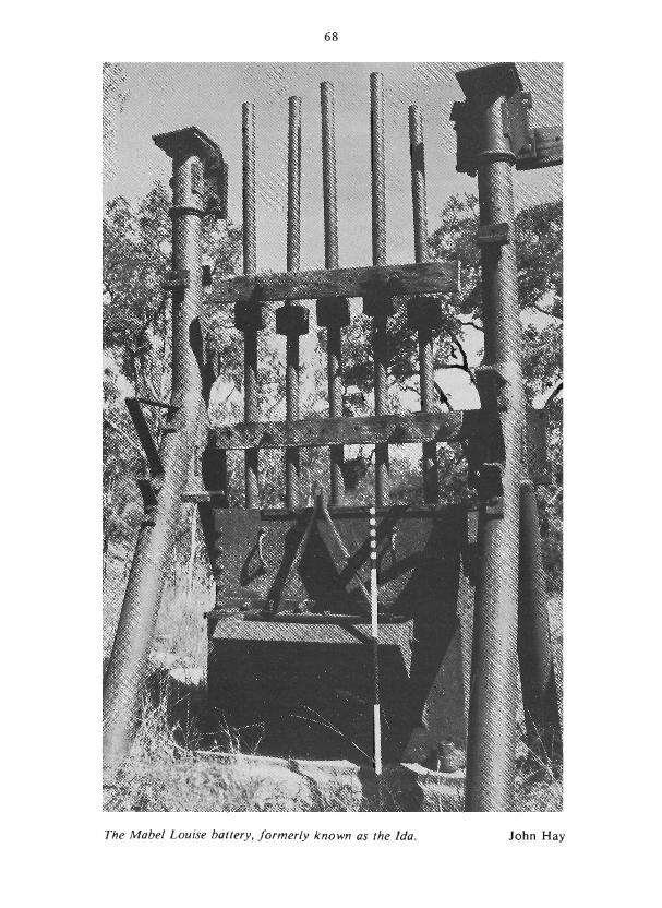
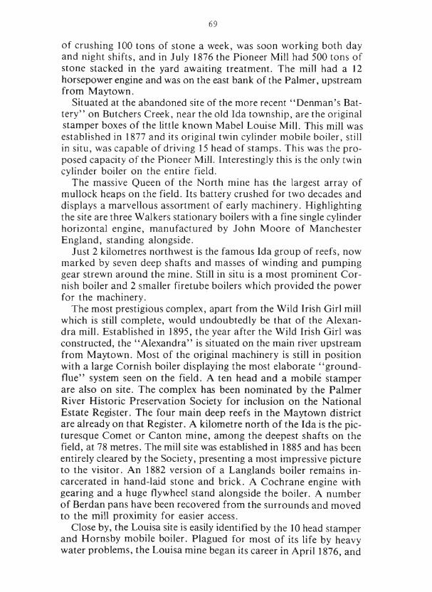
The Mabel Louise battery, formerly known as the Ida. John Hay
69
of crushing 100 tons of stone a week, was soon working both day and night shifts, and in July 1876 the Pioneer Mill had 500 tons of stone stacked in the yard awaiting treatment. The mill had a 12 horsepower engine and was on the east bank of the Palmer, upstream from Maytown.
Situated at the abandoned site of the more recent "Denman's Battery" on Butchers Creek, near the old Ida township, are the original stamper boxes of the little known Mabel Louise Mill. This mill was established in 1877 and its original twin cylinder mobile boiler, still in situ, was capable of driving 15 head of stamps. This was the proposed capacity of the Pioneer Mill. Interestingly this is the only twin cylinder boiler on the entire field.
The massive Queen of the North mine has the largest array of mullock heaps on the field. Its battery crushed for two decades and displays a marvellous assortment of early machinery. Highlighting the site are three Walkers stationary boilers with a fine single cylinder horizontal engine, manufactured by John Moore of Manchester England, standing alongside.
Just 2 kilometres northwest is the famous Ida group of reefs, now marked by seven deep shafts and masses of winding and pumping gear strewn around the mine. StiU in situ is a most prominent Cornish boiler and 2 smaller firetube boilers which provided the power for the machinery.
The most prestigious complex, apart from the Wild Irish Girl mill which is still complete, would undoubtedly be that of the Alexandra mill. Established in 1895, the year after the Wild Irish Girl was constructed, the "Alexandra" is situated on the main river upstream from Maytown. Most of the original machinery is still in position with a large Cornish boiler displaying the most elaborate "ground-flue" system seen on the field. A ten head and a mobile stamper are also on site. The complex has been nominated by the Palmer River Historic Preservation Society for inclusion on the National Estate Register. The four main deep reefs in the Maytown district are already on that Register. A kilometre north of the Ida is the picturesque Comet or Canton mine, among the deepest shafts on the field, at 78 metres. The mill site was established in 1885 and has been entirely cleared by the Society, presenting a most impressive picture to the visitor. An 1882 version of a Langlands boiler remains incarcerated in hand-laid stone and brick. A Cochrane engine with gearing and a huge flywheel stand alongside the boiler. A number of Berdan pans have been recovered from the surrounds and moved to the mill proximity for easier access.
Close by, the Louisa site is easUy identified by the 10 head stamper and Hornsby mobile boiler. Plagued for most of its life by heavy water problems, the Louisa mine began its career in April 1876, and

70

71
was worked spasmodically right up until 1941. Ahhough the 10 head Enterprise Mill is not the original one, the Tangye boiler at the shaft entrance was used originally for the mine's winding and pumping operations. Besides the heavy water problem, the very hard rock peculiar to the Palmer reefs, at times had to be burnt prior to crushing. As well fuel timber became scarce and had to be carted at considerable cost.
By 1890 there were 158 reef mines located throughout the Palmer, one third of them around the Maytown. Although more isolated, the outer area mines, also played an important role during early reefing. With the assistance of Sam Elliott, who spent the past 36 years on the North Palmer, surveys into this area have been carried out by the Society. Sam had operated the Wild Irish Girl battery from 1945 until 1976. During that period he located many of these old mines and re-opened some in order to procure payable stone. As the only surviving complete mill on the entire field, the Wild Irish Girl is Hsted on the National Estate Register along with 20 hectares of the old alluvial workings.
One of the most important yet unrecognised mines recently relocated on Cradle Creek is the British Lion, a shallow open-cut reef, first worked in 1876. By 1900 a 5 head stamper mill had been erected on site. Judging by the haul roads, the British Lion machine treated stone from various mines in that isolated region. Today a Mazefield - Auchland battery box and cam shaft lie abandoned near the hand-stoned forge. Nearby the hand-packed dam still retains water.
The well concealed Hidden Treasure mine, located on the opposite watershed to the south of the British Lion, employed a prodigious 6 kilometre haul road leading from the mine to the treatment mill, debatably either Burton's Battery or the British Lion, both of which are in the same area. Entirely hand-cut, this road braves terrain that would make modern vehicles falter and is a splendid example of early road making techniques. Sam Elliott re-located the huge excavated mill site at Burton's Battery with its fine display of stone retort stand.
At the Mount Atlas group, the Walhalla and the Nonpareil, the Duffer, Christmas and Atlas reefs have now been located and identified. The old site of Echo Town at the base of Mount Adas is marked today by a stone boiler stand where Binnie erected his stamper mill in 1876. His house site was benched into the steep hill behind the battery alongside the precarious dray track leading from the various mines. The single, stone "cooking oven" still marks this house site. As the mountainous track used to transport Binnie's machine into the river was so steep, Binnie could not get wagon cartage for his Mill when attempting to move it some years later. He eventually had to raft his entire Mill 6 kilometres downstream dur-

72
ing the monsoonal flood period, re-erecting it at German Bar. In 1882 Binnie removed a 5 head battery and 12 horsepower engine from Revolver Point, and transported this load over 300 kilometres distance to re-erect it at,Top Camp on the Goldsborough field on the Mulgrave River, southwest of Cairns.
From the bumper year of 1878 when 120,233 ounces of gold was produced from the Palmer reefs, the industry declined rapidly. The amorphous mullock heaps dotting the bushland and rotting iron bark shoring are the remnants that have survived the years and stand in silent testimony to that period. Machinery, majestic in its isolation, forms a huge decaying museum.
The old capital itself, Maytown, lies deserted now on a grass covered ridge rising from the rocky water-holed Palmer. The neat hand stoned street gutters and footpaths adorn the shop fronts that have long since disappeared. The only structures now left standing are the "Replica Miners Hut" and the "Pioneer Monument" both erected by the Palmer River Historic Preservation Society. Although Maytown was abandoned during the Second World War, the deserted streets still resound to the tread of activity as visitors come and go, leaving nought but the dust to settle.
BIBLIOGRAPHY — PUBLISHED REFERENCES North Most Australia — 1921. Robert Logan Jack. My Life On A Tropic Goldfield — 1944. J. H. Binnie. Readings In Far North Queensland Mining History — Vol. 1. 1980. N. Kirkman. Report On A Visit To The Palmer Goldfield — 1899. R. L. Jack. Prospecting For Gold On The Conglomerate Range — 1896. R. L. Jack. Cooktown Courier — 1875. Cooktown Herald — Jan 1877. The Golden Age — July 1876. Queensland Government Mining Journal — 1901. Queensland Votes and Proceedings — 1897. The Cairns Post — May 1915. The Cairns Post — July 1934.
UNPUBLISHED REFERENCES AND FIELD INFORMATION SUPPLIED BY:
Mr Bill Lane — Palmer Prospector and past owner of the "Wild Irish Girl" battery. Mr Sonny Parsons — One time Packer and Mailman from Maytown. The Late Mr Sam Elliott — Prospector, Hard-rock Miner and past owner of the "Wild Irish Girl" battery. Deceased hfe-member of the Palmer River Historic Preservation Society.