Remedial Investigation Report - Welcome to NYC.gov€¦ · RIR Remedial Investigation Report SCO...
28
CITY ISLAND ESTATES CITY ISLAND, BRONX, NEW YORK Remedial Investigation Report NYC VCP Site Number: 14CVCP169X Prepared for: City Island Reserve LLC 152 West 57 th Street – 60 th Floor New York, NY 10019 (212) 649-9700 Prepared by: Carlin-Simpson & Associates 61 Main Street Sayreville, NJ 08872 732-432-5757 September 2013
-
Upload
doannguyet -
Category
Documents
-
view
219 -
download
0
Transcript of Remedial Investigation Report - Welcome to NYC.gov€¦ · RIR Remedial Investigation Report SCO...
CITY ISLAND ESTATES
CITY ISLAND, BRONX, NEW YORK
Remedial Investigation Report NYC VCP Site Number: 14CVCP169X
Prepared for:
City Island Reserve LLC
152 West 57th Street – 60th Floor
New York, NY 10019
(212) 649-9700
Prepared by:
Carlin-Simpson & Associates
61 Main Street
Sayreville, NJ 08872
732-432-5757
September 2013
REMEDIAL INVESTIGATION REPORT
TABLE OF CONTENTS
LIST OF ACRONYMS 4
CERTIFICATION 5 EXECUTIVE SUMMARY 6 REMEDIAL INVESTIGATION REPORT 11
1.0 SITE BACKGROUND 11 1.1 Site Location and Current Usage 11 1.2 Proposed Redevelopment Plan 11
1.3 Description of Surrounding Property 12 2.0 SITE HISTORY 12
2.1 Past Uses and Ownership 12
2.2 Previous Investigations and Remedial Actions 12 2.3 Site Inspection 17 2.4 Areas of Concern 17
3.0 PROJECT MANAGEMENT 17 3.1 Project Organization 17 3.2 Health and Safety 18
3.3 Materials Management 18 4.0 REMEDIAL INVESTIGATION ACTIVITIES 18
4.1 Geophysical Investigation 18
4.2 Borings and Monitoring Wells 19 4.3 Sample Collection and Chemical Analysis 21
5.0 ENVIRONMENTAL EVALUATION 24
5.1 Geological and Hydrogeological Conditions 24 5.2 Soil Chemistry 25 5.3 Groundwater Chemistry 26
5.4 Soil Vapor Chemistry 26 5.5 Prior Activity 27 5.6 Impediments to Remedial Action 27
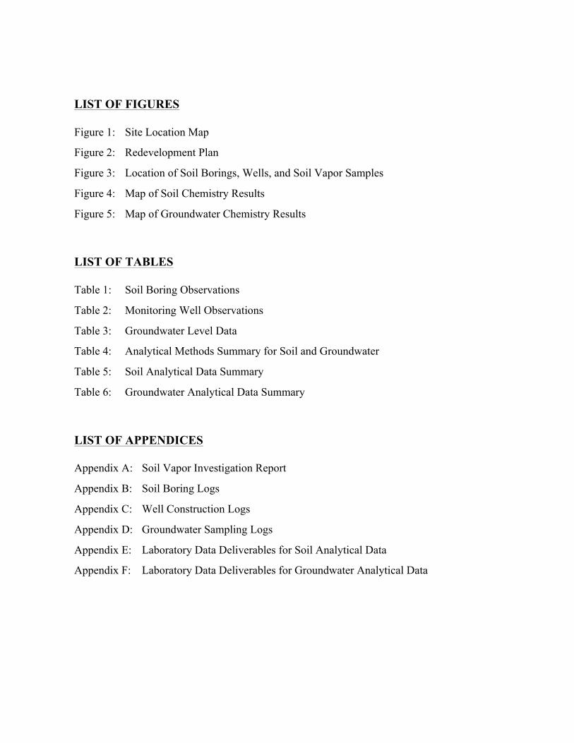
LIST OF FIGURES
Figure 1: Site Location Map
Figure 2: Redevelopment Plan
Figure 3: Location of Soil Borings, Wells, and Soil Vapor Samples
Figure 4: Map of Soil Chemistry Results
Figure 5: Map of Groundwater Chemistry Results
LIST OF TABLES
Table 1: Soil Boring Observations
Table 2: Monitoring Well Observations
Table 3: Groundwater Level Data
Table 4: Analytical Methods Summary for Soil and Groundwater
Table 5: Soil Analytical Data Summary
Table 6: Groundwater Analytical Data Summary
LIST OF APPENDICES
Appendix A: Soil Vapor Investigation Report
Appendix B: Soil Boring Logs
Appendix C: Well Construction Logs
Appendix D: Groundwater Sampling Logs
Appendix E: Laboratory Data Deliverables for Soil Analytical Data
Appendix F: Laboratory Data Deliverables for Groundwater Analytical Data
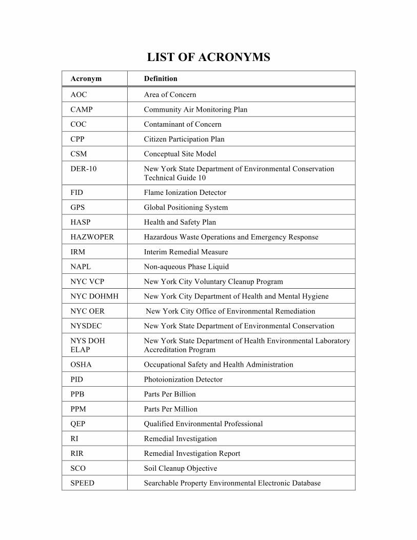
LIST OF ACRONYMS Acronym Definition
AOC Area of Concern
CAMP Community Air Monitoring Plan
COC Contaminant of Concern
CPP Citizen Participation Plan
CSM Conceptual Site Model
DER-10 New York State Department of Environmental Conservation Technical Guide 10
FID Flame Ionization Detector
GPS Global Positioning System
HASP Health and Safety Plan
HAZWOPER Hazardous Waste Operations and Emergency Response
IRM Interim Remedial Measure
NAPL Non-aqueous Phase Liquid
NYC VCP New York City Voluntary Cleanup Program
NYC DOHMH New York City Department of Health and Mental Hygiene
NYC OER New York City Office of Environmental Remediation
NYSDEC New York State Department of Environmental Conservation
NYS DOH ELAP
New York State Department of Health Environmental Laboratory Accreditation Program
OSHA Occupational Safety and Health Administration
PID Photoionization Detector
PPB Parts Per Billion
PPM Parts Per Million
QEP Qualified Environmental Professional
RI Remedial Investigation
RIR Remedial Investigation Report
SCO Soil Cleanup Objective
SPEED Searchable Property Environmental Electronic Database
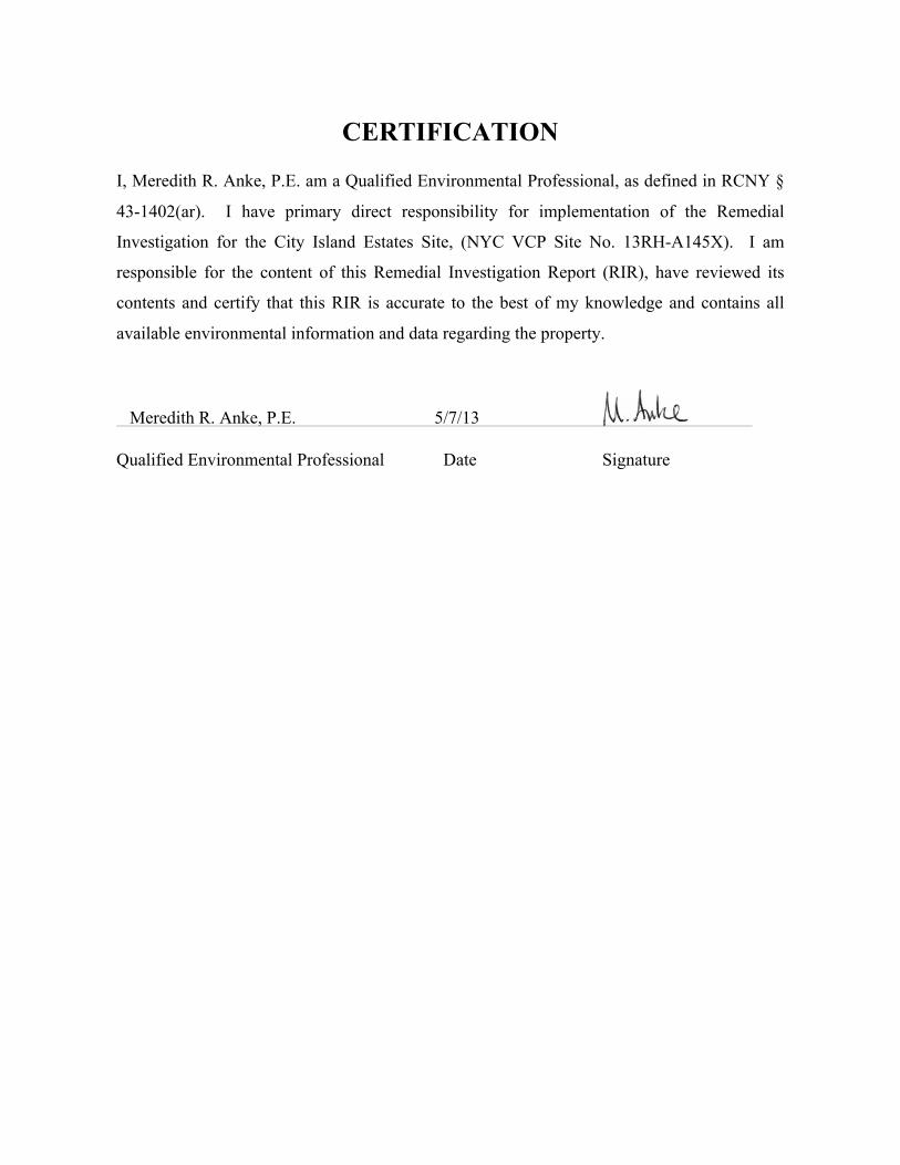
CERTIFICATION
I, Meredith R. Anke, P.E. am a Qualified Environmental Professional, as defined in RCNY §
43-1402(ar). I have primary direct responsibility for implementation of the Remedial
Investigation for the City Island Estates Site, (NYC VCP Site No. 13RH-A145X). I am
responsible for the content of this Remedial Investigation Report (RIR), have reviewed its
contents and certify that this RIR is accurate to the best of my knowledge and contains all
available environmental information and data regarding the property.
Meredith R. Anke, P.E. 5/7/13
Qualified Environmental Professional Date Signature
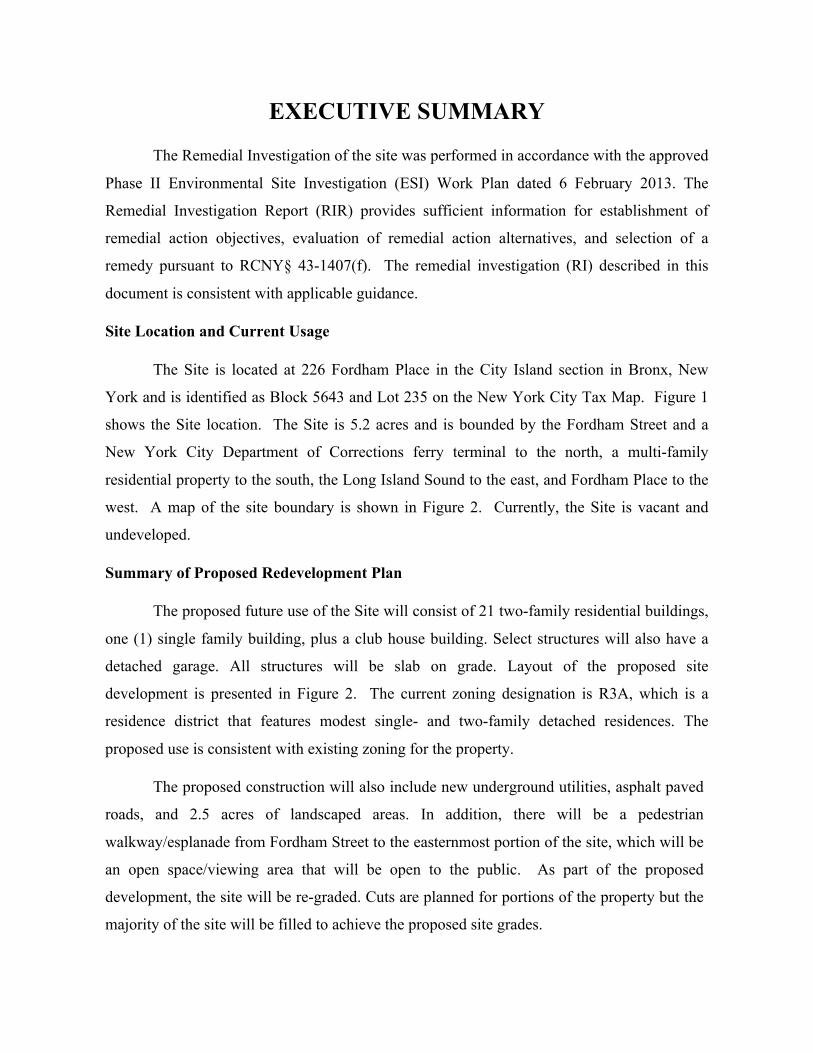
EXECUTIVE SUMMARY
The Remedial Investigation of the site was performed in accordance with the approved
Phase II Environmental Site Investigation (ESI) Work Plan dated 6 February 2013. The
Remedial Investigation Report (RIR) provides sufficient information for establishment of
remedial action objectives, evaluation of remedial action alternatives, and selection of a
remedy pursuant to RCNY§ 43-1407(f). The remedial investigation (RI) described in this
document is consistent with applicable guidance.
Site Location and Current Usage
The Site is located at 226 Fordham Place in the City Island section in Bronx, New
York and is identified as Block 5643 and Lot 235 on the New York City Tax Map. Figure 1
shows the Site location. The Site is 5.2 acres and is bounded by the Fordham Street and a
New York City Department of Corrections ferry terminal to the north, a multi-family
residential property to the south, the Long Island Sound to the east, and Fordham Place to the
west. A map of the site boundary is shown in Figure 2. Currently, the Site is vacant and
undeveloped.
Summary of Proposed Redevelopment Plan
The proposed future use of the Site will consist of 21 two-family residential buildings,
one (1) single family building, plus a club house building. Select structures will also have a
detached garage. All structures will be slab on grade. Layout of the proposed site
development is presented in Figure 2. The current zoning designation is R3A, which is a
residence district that features modest single- and two-family detached residences. The
proposed use is consistent with existing zoning for the property.
The proposed construction will also include new underground utilities, asphalt paved
roads, and 2.5 acres of landscaped areas. In addition, there will be a pedestrian
walkway/esplanade from Fordham Street to the easternmost portion of the site, which will be
an open space/viewing area that will be open to the public. As part of the proposed
development, the site will be re-graded. Cuts are planned for portions of the property but the
majority of the site will be filled to achieve the proposed site grades.
Summary of Past Uses of Site and Areas of Concern
The Site was developed prior to 1893 for use as a shipyard with woodworking,
storage, a machine shop, and a dwelling. The Site has been used since that time for various
maritime related uses, including ship and yacht building, boat storage and boat repair, sail
making, and a diving business. From 1976 to 1978, the Site was also used as a contractor’s
yard. Sometime between 1978 and 1981, the Site was filled to its current grade.
The following structures on the property were demolished in 2012: 1) a two-story
wood frame structure in the northern portion of the site, which was reportedly used as an
office building (green building); 2) a one-story metal building in the western portion of the
site, which was reportedly used as a machine shop (red building); 3) a two-story metal
building in the center, northern portion of the property, which was reportedly used as a garage
and was also used by a diving business (blue building); and 4) a dilapidated two-story wood
frame structure in the southwest corner of the site, which was at one time identified as a
carpentry building (brown building).
The following Areas of Concern have been identified and addressed under previous
remedial actions:
1. Two (2) 10,000-gallon USTs which were removed and documented by HDR’s August
2007 Tank Closure Report;
2. Previous boring B-3 and a 550-gallon UST, which has not been located since GTA’s
2003 Investigation. This tank is believed to have been removed based on multiple test
pits and GPR surveys;
3. A former drum storage area, which was excavated and documented by Carlin-
Simpson’s July 2012 RACR. Residual levels of SVOCs and metals above Restricted
Residential SCOs remain and are believed to be associated with historic fill;
4. Stained surface area west of the former garage building (blue building), which was
excavated and documented by HDR’s August 2007 Tank Closure Report. Excavated
material was stockpiled on-site until the 2011-2012 Remedial Action;
5. Stained surface area near southeast corner of the site, which was excavated and
documented by HDR’s August 2007 Tank Closure Report. Excavated material was
stockpiled on-site until the 2011-2012 Remedial Action;
6. Area of discarded batteries, which was excavated and documented by HDR’s August
2007 Tank Closure Report. Excavated material was stockpiled on-site until the 2011-
2012 Remedial Action;
7. Discolored area east of the office building (green building), which was excavated and
documented by Carlin-Simpson’s July 2012 RACR; Residual levels of SVOCs and
metals above Restricted Residential SCOs remain and are believed to be associated
with historic fill;
8. Previous boring B-10 and an area of high metal concentrations, which was excavated
and documented by HDR’s August 2007 Tank Closure Report. Excavated material
was stockpiled on-site until the 2011-2012 Remedial Action;
9. Previously stockpiled areas, which were removed. Residual levels of SVOCs and
metals above Restricted Residential SCOs remain and are believed to be associated
with historic fill; and
10. Groundwater contamination, which was addressed under NYSDEC Petroleum Spill
07-02222 by installing an absorbent sock in a groundwater well in response to a sheen/
lens identified during excavation. No petroleum was identified, and no oil recovery
was required. The spill was closed on October 17, 2012.
The scope of work for this RI was developed in response to the proposed development
project. An investigation of soil, soil vapor, and groundwater was performed to characterize
the Site for potential environmental contamination from historic on-site uses, operations,
filling, etc. The sampling event was designed to provide general coverage across the entire
site and to characterize the historic fill material that remains on Site.
Summary of the Work Performed under the Remedial Investigation
As part of this investigation, Carlin-Simpson & Associates performed the following
scope of work:
1. Installed 12 soil borings across the entire project Site, and collected 19 soil
samples for chemical analysis from the soil borings to evaluate soil quality;
2. Installed 5 groundwater monitoring wells throughout the Site to establish
groundwater flow and collected 5 groundwater samples for chemical analysis to
evaluate groundwater quality;
In addition, Environmental Maintenance Contractors, Inc. (EMC) performed the
following scope of work:
1. Attempted to install 13 soil vapor probes across the project Site and collected 10
samples for chemical analysis. Three probes were not sampled due to a shallow
water table.
Summary of Environmental Findings
1. The majority of the Site is relatively flat with surface elevations ranging from
approximately elevation +10.0 feet to elevation +20.0 feet. In the eastern portion
of the property, the surface elevations slope down steeply to the adjacent Long
Island Sound, which has a mean high water level at elevation +2.05.
2. Depth to groundwater ranges from 10.25 feet to 14.25 feet below the existing
ground surface at the Site. Groundwater flow beneath the Site is tidally influenced
as a result of the adjacent Long Island Sound.
3. Depth to bedrock is approximately 13 feet in the northwest portion of the Site.
Bedrock is more than 25 feet below the surface in the remainder of the site.
4. The stratigraphy of the site, from the surface down, consists of 6 feet to more than
17 feet of fill material (Class 7) that is underlain by medium dense to dense Sand
or Silty Sand with Gravel and occasional cobbles (Class 3b).
5. Soil samples collected during the RI showed no detectable concentrations of
PCBs. One VOC (acetone) was detected in one sample at a concentration that
exceeds the Unrestricted Use SCO but is well below the Residential Use SCO. All
other VOCs detected were found to be at very low levels, including PCE at a max
concentration of 0.0007 ppm. One pesticide (4,4’-DDT) was detected at a
concentration that slightly exceeded the Unrestricted Use SCO but is well below
the Residential Use SCO. Five SVOCs including benzo(a)anthracene (max 3.2
ppm), benzo(a)pyrene (max 3.9 ppm), benzo(b)fluoranthene (max 4.7 ppm),
dibenz(a,h)anthracene (max 0.80 ppm), and indeno(1,2,3-cd)pyrene (max 3.1 ppm)
exceeded Restricted Residential Use Soil Cleanup Objectives (SCOs) in most
shallow and roughly a quarter of the deep soil samples. These SVOCs are all in a
class of compounds known as polycyclic aromatic hydrocarbons (PAHs), which
are commonly found in historic fill material. Eight metals exceeded Track 1
Unrestricted Use SCOs, and six of these metals, arsenic (max of 20.0 ppm),
barium (max of 506 ppm), chromium (max of 113 ppm), copper (max of 382
ppm), lead (max of 3,960 ppm), and mercury (max of 4.9 ppm), also exceeded
Track 2 Restricted Residential Use SCOs. These sampling results, with the
exception of two shallow hotspot areas, one for lead and one for mercury, are
consistent with findings in historic fill material at Sites throughout NYC.
6. Groundwater samples collected during the RI showed that dissolved metals
including antimony, cobalt, iron, magnesium, manganese, and sodium exceeded
the New York State 6 NYCRR Part 703.5 Class GA groundwater quality standards
(GQS). Two SVOCs (benzo(a)anthracene and benzo(b)fluoranthene) were
detected above GQSs in one sample. Three petroleum-related VOCs were also
detected at trace concentrations, but were well below their GQSs. Groundwater
samples showed no detectable concentrations of PCBs or pesticides. Given that
the Site is located immediately adjacent to the Long Island Sound, we expect that
the groundwater below the Site is brackish.
7. Soil vapor samples collected during the RI showed several petroleum and
chlorinated VOCs at generally low concentrations. Acetone (maximum of 89
µg/m3) and carbon disulfide (maximum of 79 µg/m3) were detected in all samples.
Most other detections were generally less than 10 µg/m3. PCE was identified in
nine of ten soil vapor samples at a maximum concentration of 12 µg/m3, TCE was
identified in two of the ten soil vapor samples at a maximum concentration of 1.0
µg/m3, carbon tetrachloride was identified in two samples at a max concentration
of 1.0 µg/m3, and 1,1,1-TCA was identified in five samples at a max concentration
of 6.2 µg/m3. None of these chlorinated VOCs were identified in groundwater
samples collected during this RI, and only PCE was identified at trace levels in
soil. All soil vapor concentrations were reported below the monitoring level ranges
established within the NYS DOH soil vapor guidance matrices. Methane was only
detected in one sample at 0.032 percent, which is well below its explosive limit.
REMEDIAL INVESTIGATION REPORT
1.0 SITE BACKGROUND
City Island Reserve LLC has enrolled in the New York City Voluntary Cleanup
Program (NYC VCP) to investigate and remediate a 6.4-acre site located at 226 Fordham
Place in the City Island section of Bronx, New York. Residential use is proposed for the
property. The RI work was performed between March and April 2013. This RIR summarizes
the nature and extent of contamination and provides sufficient information for establishment
of remedial action objectives, evaluation of remedial action alternatives, and selection of a
remedy that is protective of human health and the environment consistent with the use of the
property pursuant to RCNY§ 43-1407(f).
1.1 Site Location and Current Usage
The Site is located at 226 Fordham Place in the City Island section in Bronx, New
York and is identified as Block 5643 and Lot 235 on the New York City Tax Map. Figure 1
shows the Site location. The Site is 6.4 acres and is bounded by the Fordham Street and a
New York City Department of Corrections ferry terminal to the north, a multi-family
residential property to the south, the Long Island Sound to the east, and Fordham Place to the
west. A map of the site boundary is shown in Figure 2. Currently, the Site is vacant and
undeveloped.
1.2 Proposed Redevelopment Plan
The proposed future use of the Site will consist of 21 two-family residential buildings,
one (1) single family building, plus a club house building. Select structures will also have a
detached garage. All structures will be slab on grade. Layout of the proposed site
development is presented in Figure 2. The current zoning designation is R3A, which is a
residence district that features modest single- and two-family detached residences. The
proposed use is consistent with existing zoning for the property.
The proposed construction will also include new underground utilities, asphalt paved
roads, and landscaped areas. In addition, there will be a pedestrian walkway/esplanade from
Fordham Street to the easternmost portion of the site, which will be an open space/viewing
area that will be open to the public. As part of the proposed development, the site will be re-
graded using the on-site soil material. Cuts are planned for portions of the property but the
majority of the site will be filled to achieve the proposed site grades.
1.3 Description of Surrounding Property
The area immediately surrounding the Site generally consists of residential and
commercial properties. There are single family and multi-family residential properties to the
west and multi-family residential buildings to the south. To the north of the site, across
Fordham Street, are commercial and residential properties. There are no sensitive receptors
such as schools, hospitals, or day care facilities within a 500-foot radius of the site.
Figure 2 shows the surrounding land usage.
2.0 SITE HISTORY
2.1 Past Uses and Ownership
The Site was developed prior to 1893 for use as a shipyard with woodworking,
storage, a machine shop, and a dwelling. The Site has been used since that time for various
maritime related uses, including ship and yacht building, boat storage and boat repair, sail
making, and a diving business. From 1976 to 1978, the Site was also used as a contractor’s
yard. Sometime between 1978 and 1981, the Site was filled to its current grade.
The following structures on the property were demolished in 2012: 1) a two-story
wood frame structure in the northern portion of the site, which was reportedly used as an
office building (green building); 2) a one-story metal building in the western portion of the
site, which was reportedly used as a machine shop (red building); 3) a two-story metal
building in the center, northern portion of the property, which was reportedly used as a garage
and was also used by a diving business (blue building); and 4) a dilapidated two-story wood
frame structure in the southwest corner of the site, which was at one time identified as a
carpentry building (brown building).
2.2 Previous Investigations and Remedial Actions
A number of environmental studies and remedial actions have been performed at the
subject site. These studies and remedial actions include the following:
Phase I Environmental Site Assessment (ESA) by Geo-Technology Associates (GTA), 2003:
Prior to the Phase I ESA, GTA performed a preliminary geotechnical investigation at the site.
Four test pits and four borings were performed to determine the subsurface conditions.
Existing fill was encountered in each of the test locations and generally consisted of silty sand
and gravel mixed with larger cobble/boulder size pieces of concrete or rock. Varying amounts
of wood, cinders, brick, metal, asphalt, and rubber were also encountered within the fill layer.
The GTA Phase I ESA in 2003 identified the following Recognized Environmental
Conditions (RECs) associated with the site: 1) historic site use as a shipyard; 2) on-site above
and underground storage tanks; 3) historic fill; 4) a drum storage area; and 5) the adjacent
land use as a former bulk oil and gasoline storage facility. The GTA Phase I ESA report also
referred to an older Phase I ESA report by Dames and Moore (DM). During The DM Phase I
ESA, seven (7) aboveground storage tanks (ASTs) were noted on the site, which included two
(2) 2,000-gallon ASTs, one (1) 1,000-gallon AST, one (1) 550-gallon fuel oil AST, one (1)
550-gallon waste oil AST, and two (2) 1,000-gallon waste oil ASTs. However, most of these
tanks had been removed from the site by the time GTA performed their Phase I ESA in 2003.
GTA only observed two (2) ASTs on the property, which included a 275-gallon fuel oil AST
in the office building and a 550-gallon fuel oil AST in the carpentry building. In addition,
there were two (2) 10,000-gallon ASTs that contained a helium/oxygen mixture and were
reportedly used by the diving school.
Phase II Environmental Site Investigation (ESI), GTA, 2003: Following the Phase I ESA and
preliminary geotechnical investigation, GTA completed a Phase II Environmental Site
Investigation (ESI) at the site in 2003. The Phase II ESI included conducting 15 test pits and 1
soil boring, collecting a total of 20 soil samples; sampling of 8 groundwater wells, and
investigation of the area of the two (2) 10,000 gallon underground storage tanks (USTs) in the
western portion of the site. Analytical testing for soil indicated that some polycyclic aromatic
hydrocarbons (PAHs) and metals were detected at concentrations exceeding the TAGM
Recommended Soil Cleanup Objectives (RSCO). The groundwater sample collected near the
10,000 gallon USTs contained some SVOCs above the NYSDEC Groundwater Quality
Standards (GWQS). In addition, some metals were detected at concentrations exceeding the
GWQS in one or more of the groundwater sampling locations. During the study, GTA also
encountered a 550-gallon UST in an open field area to the southeast of the drum storage area.
Soil Evaluation Study, GTA, 2003: GTA then performed a second subsurface investigation to
horizontally and vertically delineate some of the soil contamination areas. As part of the
supplemental investigation, a geophysical survey was performed at the site to assess the
subsurface for the possible presence of buried barges or additional buried tanks. The results of
the survey did not indicate the presence of a large metallic anomaly. Smaller anomalies were
detected but upon investigation, subsurface metal was not encountered. Twenty-two (22) test
pits were conducted, and 92 soil samples were analyzed for mercury, 27 samples were
analyzed for lead, and 10 samples were analyzed for PAHs.
Phase II ESI by HDR|LMS, 2005: In 2005, HDR|LMS performed a Phase II ESI at the site.
The investigation included a geophysical survey in areas that were not previously surveyed
due to heavy vegetation. A large metallic anomaly was identified in the central, eastern
portion of the property, which was further investigated with test pits and found to be a large
barge that had been sunk as part of the historic filling activities at the site. The investigation
also included installation and sampling of 3 groundwater wells, as well as collecting 8 surface
soil samples in select areas of the site. Groundwater samples collected from monitoring wells
were below the GWQS for VOCs and SVOCs. Some metals were detected at concentrations
that exceeded the GWQS, but those concentrations were likely due to unfiltered samples. Soil
conditions were generally consistent with the previous investigations.
Remedial Action Work Plan, HDR|LMS, 2006: A Remedial Action Work Plan (RAWP) was
then prepared by HDR|LMS in 2006 for submittal to the New York City Department of
Environmental Protection (NYCDEP). The RAWP identified the following Areas of Concern
(AOCs): 1) Two (2) 10,000-gallon USTs; 2) Boring B-3 and a 550-gallon UST; 3) a former
drum storage area; 4) stained surface area west of the garage building (blue building); 5)
stained surface area near southeast corner of the site; 6) area of discarded batteries; 7)
discolored area east of the office building (green building); and 8) boring B-10 and an area of
high metal concentrations. The RAWP also outlined the procedures to address these AOCs
and presented a plan for a surface cover system at the site. NYCDEP approved the RAWP on
May 31, 2007 by issuing a Notice to Proceed in response to the May 1, 2007 Restrictive
Declaration.
Underground Storage Tank Closure Report, HDR|LMS, 2007 In May 2007, the Site was
reported to the NYSDEC and Spill No. 0702222 was assigned to the site. An Underground
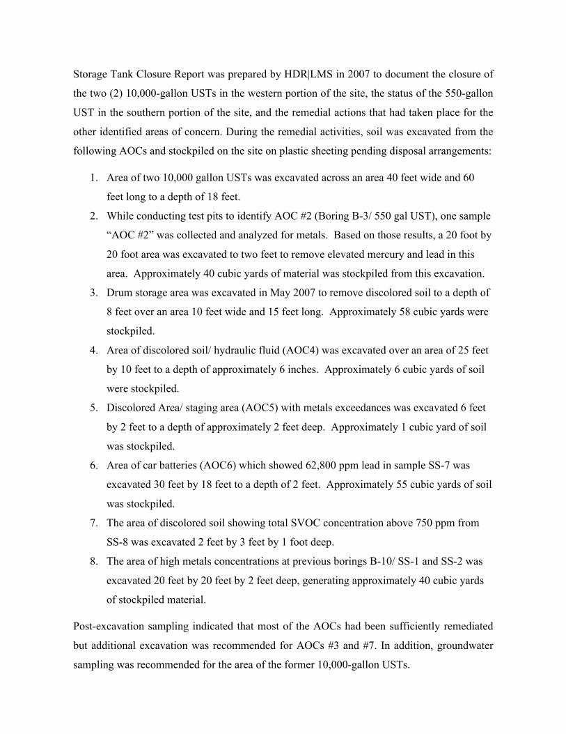
Storage Tank Closure Report was prepared by HDR|LMS in 2007 to document the closure of
the two (2) 10,000-gallon USTs in the western portion of the site, the status of the 550-gallon
UST in the southern portion of the site, and the remedial actions that had taken place for the
other identified areas of concern. During the remedial activities, soil was excavated from the
following AOCs and stockpiled on the site on plastic sheeting pending disposal arrangements:
1. Area of two 10,000 gallon USTs was excavated across an area 40 feet wide and 60
feet long to a depth of 18 feet.
2. While conducting test pits to identify AOC #2 (Boring B-3/ 550 gal UST), one sample
“AOC #2” was collected and analyzed for metals. Based on those results, a 20 foot by
20 foot area was excavated to two feet to remove elevated mercury and lead in this
area. Approximately 40 cubic yards of material was stockpiled from this excavation.
3. Drum storage area was excavated in May 2007 to remove discolored soil to a depth of
8 feet over an area 10 feet wide and 15 feet long. Approximately 58 cubic yards were
stockpiled.
4. Area of discolored soil/ hydraulic fluid (AOC4) was excavated over an area of 25 feet
by 10 feet to a depth of approximately 6 inches. Approximately 6 cubic yards of soil
were stockpiled.
5. Discolored Area/ staging area (AOC5) with metals exceedances was excavated 6 feet
by 2 feet to a depth of approximately 2 feet deep. Approximately 1 cubic yard of soil
was stockpiled.
6. Area of car batteries (AOC6) which showed 62,800 ppm lead in sample SS-7 was
excavated 30 feet by 18 feet to a depth of 2 feet. Approximately 55 cubic yards of soil
was stockpiled.
7. The area of discolored soil showing total SVOC concentration above 750 ppm from
SS-8 was excavated 2 feet by 3 feet by 1 foot deep.
8. The area of high metals concentrations at previous borings B-10/ SS-1 and SS-2 was
excavated 20 feet by 20 feet by 2 feet deep, generating approximately 40 cubic yards
of stockpiled material.
Post-excavation sampling indicated that most of the AOCs had been sufficiently remediated
but additional excavation was recommended for AOCs #3 and #7. In addition, groundwater
sampling was recommended for the area of the former 10,000-gallon USTs.
Environmental Site Investigation, Carlin-Simpson & Associates, June 2011: In 2011, Carlin-
Simpson & Associates was retained by the current property owner to address the outstanding
issues, to the extent feasible, that were outlined in the 30 July 2010 letter from the New York
State Department of Environmental Conservation (NYSDEC) regarding the subject property.
A site visit and subsurface investigation were performed. The findings of the study indicated
the following: 1) there was residual groundwater contamination present in the area of the
former USTs in the western portion of the site; 2) there was a possible 550-gallon
underground storage tank (UST) buried in the southern portion of the site; 3) remedial action
was still required for two (2) of the previously identified areas of concern (AOCs); and 4) the
soil from the former excavation areas was still stockpiled in four (4) areas on the site.
The NYSDEC responded to the Environmental Site Investigation Report with a letter dated 20
July 2011 requesting additional investigation for portions of the site and preparation of a
Remedial Action Work Plan (RAWP).
Remedial Action Work Plan, Carlin-Simpson & Associates, August 2011: A RAWP dated
August 2011 was subsequently prepared by Carlin-Simpson & Associates along with a
RAWP Addendum dated 9 September 2011. The RAWP was approved by NYSDEC in a
letter dated 12 September 2011.
A Supplemental Site Investigation was performed by Carlin-Simpson & Associates in
September and October 2011 as outlined in the approved RAWP. The results of the
investigation were presented in a report dated 29 November 2011. The purpose of the study
was to perform a site visit to further inspect the interior of the blue building for staining and
floor slab cracks, to perform a magnetometer survey in the area of the former 550-gallon
storage tank, and to install an absorbent sock in monitoring well MW-101 to evaluate if
petroleum product remains in the groundwater near the former 10,000-gallon storage tanks. In
addition, a supplemental subsurface investigation was performed to further characterize the
subsurface soils in select areas of the site and to further assess the groundwater conditions in
the area of monitoring well MW-101. The results of the supplemental investigation did not
identify any new areas of concern or any additional areas requiring remedial action.
Remedial Action Closure Report, Carlin-Simpson & Associates, 2012: In 2012, the site was
remediated as per the NYSDEC approved RAWP. The purpose of the remedial action at the
subject site was as follows: 1) to excavate and remove site soils that have been impacted with
petroleum and/or metals in former identified areas of concern (AOC #3 and AOC #7); 2) to
excavate and remove soils that were previously excavated from identified areas of concern
and stockpiled on the site; 3) to provide for off-site disposal of contaminated soil; and 4) to
locate and remove a 550-gallon underground storage tank (UST).
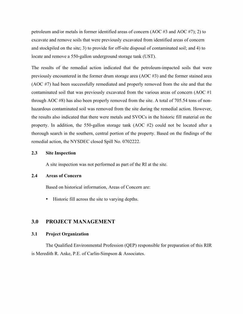
The results of the remedial action indicated that the petroleum-impacted soils that were
previously encountered in the former drum storage area (AOC #3) and the former stained area
(AOC #7) had been successfully remediated and properly removed from the site and that the
contaminated soil that was previously excavated from the various areas of concern (AOC #1
through AOC #8) has also been properly removed from the site. A total of 705.54 tons of non-
hazardous contaminated soil was removed from the site during the remedial action. However,
the results also indicated that there were metals and SVOCs in the historic fill material on the
property. In addition, the 550-gallon storage tank (AOC #2) could not be located after a
thorough search in the southern, central portion of the property. Based on the findings of the
remedial action, the NYSDEC closed Spill No. 0702222.
2.3 Site Inspection
A site inspection was not performed as part of the RI at the site.
2.4 Areas of Concern
Based on historical information, Areas of Concern are:
• Historic fill across the site to varying depths.
3.0 PROJECT MANAGEMENT
3.1 Project Organization
The Qualified Environmental Profession (QEP) responsible for preparation of this RIR
is Meredith R. Anke, P.E. of Carlin-Simpson & Associates.
3.2 Health and Safety
All work described in this RIR was performed in full compliance with applicable laws
and regulations, including Site and OSHA worker safety requirements and HAZWOPER
requirements.
3.3 Materials Management
All material encountered during the RI was managed in accordance with applicable
laws and regulations.
4.0 REMEDIAL INVESTIGATION ACTIVITIES
As part of this investigation, Carlin-Simpson & Associates performed the following
scope of work:
1. Installed 12 soil borings across the entire project Site, and collected 19 soil
samples for chemical analysis from the soil borings to evaluate soil quality;
2. Installed 5 groundwater monitoring wells throughout the Site to establish
groundwater flow and collected 5 groundwater samples for chemical analysis to
evaluate groundwater quality;
In addition, Environmental Maintenance Contractors, Inc. (EMC) performed the
following scope of work:
1. Attempted to install 13 soil vapor probes across the project Site and collected 10
samples for chemical analysis. Three probes were not sampled due to a shallow
water table.
4.1 Geophysical Investigation
A geophysical investigation was not performed as part of the Remedial Investigation
at the project Site.
4.2 Borings and Monitoring Wells
Drilling and Soil Logging
On 12-15 March 2013, General Borings Inc. installed 12 soil borings at the site under
the full-time supervision of the Qualified Environmental Profession (QEP) from Carlin-
Simpson & Associates. These borings are identified as B-101 through B-112. The boring
observations are summarized in Table 1.
The test borings were performed at the locations outlined in the approved Work Plan.
The borings were advanced using 3.25-inch I.D. hollow stem augers (HSA). Soil sampling
with two (2) foot long split spoon samplers was performed to collect semi-continuous soil
samples from each borehole. Continuous sampling was not feasible because of obstructions in
the fill (i.e. metal, concrete, cobbles, boulders, etc.) and in the underlying soil (i.e. cobbles
and boulders). At each boring location, Carlin-Simpson & Associates visually identified the
soil layers encountered, screened for volatile and semi-volatile organic vapors using a
calibrated photoionization detector (PID), and inspected for any visual and/or olfactory
evidence of contamination. No odors, stained soils, sheens, or free/residual product was noted
at any of the boring locations. A PID reading of 0.2 parts per million (ppm) was detected in
boring B-105 at a depth of 10’6” to 12’6” below the ground surface. PID readings were not
detected in any of the remaining borings during this investigation.
Boring logs that were prepared by a geotechnical engineer are attached in Appendix B.
A map showing the location of soil borings and monitoring wells is shown on Figure 3.
Groundwater Monitoring Well Construction
During this investigation, four (4) groundwater monitoring wells were installed at the
subject site. The wells were installed on 12-13 March 2013 by General Borings Inc.
Monitoring well locations are shown in Figure 3 and the monitoring well data is summarized
in Table 2. Monitoring well construction logs have also been prepared and are included in
Appendix B of this report.
While advancing the well borings, soil samples were obtained using a split spoon
sampler so that the soil samples could be inspected for evidence of contamination (i.e.
staining, odors, etc.). The soil samples were also screened with a photoionization detector
(PID), which is capable of detecting volatile and semi-volatile organic compounds (VOCs and
SVOCs). No petroleum odors or PID readings were encountered in the borings. When the
boring was completed, a two (2) inch groundwater monitoring well was constructed in the
borehole. The monitoring well was constructed as follows:
§ The borings were advanced to depths ranging from 17’0” to 22’0” beneath
the ground surface.
§ Ten (10) feet of 20 slot PVC well screen with approximately seven (7) to
12 feet of PVC casing was placed down the center of the hollow stem
augers.
§ The hollow stem augers were them slowly removed while sand pack was
installed to approximately 1’0” to 1’6” above the top of the well screen.
§ The borehole was then filled with approximately 2’0” of bentonite chips.
§ The remainder of the borehole was then filled with soil to the ground
surface where a concrete pad was constructed. A stick-up steel casing was
also installed for well protection.
After the wells were constructed, they was developed using a whale pump. The
development water was placed into 55-gallon steel drums for storage until laboratory testing
of the groundwater was conducted. During well development, the groundwater appeared to be
turbid but no petroleum odors or sheens were observed. Well development continued until the
groundwater turbidity cleared significantly. Approximately 10 to 15 gallons of water was
removed from each well during well development.
Survey
The boring, monitoring well, and soil vapor probe locations were surveyed by a
licensed land surveyor. The locations are shown on Figure 3.
Water Level Measurement
Groundwater depth was recorded at each of the monitoring well locations using a
Solinst 101 Water Level Meter, which is capable of recording the water depth to the nearest
hundredth of a foot. The water level data is included in Table 3.
4.3 Sample Collection and Chemical Analysis
Sampling performed as part of the field investigation was conducted for all Areas of
Concern and also considered other means for bias of sampling based on professional
judgment, area history, discolored soil, stressed vegetation, drainage patterns, field instrument
measurements, odor, or other field indicators. All media including soil, groundwater and soil
vapor have been sampled and evaluated in the RIR. Discrete (grab) samples have been used
for final delineation of the nature and extent of contamination and to determine the impact of
contaminants on public health and the environment. The sampling performed and presented
in this RIR provides sufficient basis for evaluation of remedial action alternatives,
establishment of a qualitative human health exposure assessment, and selection of a final
remedy.
Soil Sampling
As discussed in Section 4.2 above, soil sampling with two (2) foot long split spoon
samplers was performed to collect semi-continuous soil samples from each of the boreholes.
The split spoon sampler was decontaminated after each sample using alconox cleaner and
fresh water. A field/equipment blank was collected to verify the decontamination procedures.
Soil samples to be analyzed were collected from the split spoon samplers using disposable
equipment for each sample. The soil samples were placed into laboratory prepared
unpreserved glass jars and placed on ice in a cooler maintained at four (4) degrees Celsius.
The samples were then transported under proper chain of custody procedures to the testing
laboratory for analysis.
Quality assurance/quality control (QA/QC) samples are typically performed at a rate
of 5% (i.e. one for every 20 collected samples). During this investigation, the QA/QC samples
for soil included the following: one (1) field/equipment blank, one (1) field duplicate, and one
(1) trip blank. In addition, the laboratory prepared matrix spike (MS) and matrix spike
duplicate (MSD) samples as part of their in-house QA/QC plan.
Nineteen (19) soil samples were collected for chemical analysis during this RI. Data
on soil sample collection for chemical analyses, including dates of collection and sample
depths, is reported in Table 4. Figure 3 shows the location of samples collected in this
investigation. Laboratories and analytical methods are shown below.
Groundwater Sampling
The newly-installed and developed monitoring wells were allowed to stabilize for at
least ten (10) days prior to sampling. On 26 and 27 March 2013, Carlin-Simpson &
Associates returned to the site to collect samples from each of the wells. Prior to sampling, the
static groundwater level at each well was measured and the well casing was scanned for
volatile and semi-volatile organic vapors using a calibrated PID. The measurements are
presented in Table 2. Based on the site location, we anticipate that the groundwater beneath
the site is tidally influenced. Therefore, the observed groundwater levels are expected to
fluctuate a few feet with the tides.
Groundwater samples were collected from each of the five (5) monitoring wells using
the United States Environmental Protection Agency (USEPA) Region II Low Stress (Low
Flow) Purging and Sampling Procedures (March 1998). Dedicated tubing was used at each
well location.
Field measurements for pH, specific conductivity, dissolved oxygen (DO),
temperature, turbidity, flow rate and water level, as well as visual and olfactory field
observations, were monitored and recorded during well purging. A well was considered
stabilized and ready for sample collection when the recorded field parameters had stabilized
for three consecutive readings as follows: ±0.1 for pH, ±3% for specific conductivity and
temperature, and ±10% for DO and turbidity. The recorded water quality measurements are
included on the Groundwater Sampling Logs in Appendix D.
The groundwater samples were placed into laboratory prepared glass or plastic bottles
and placed on ice in a cooler maintained at four (4) degrees Celsius. The samples were then
transported under proper chain of custody procedures to the testing laboratory for analysis.
During this investigation, the QA/QC samples for groundwater included the
following: one (1) trip blank. In addition, the laboratory prepared matrix spike (MS) and
matrix spike duplicate (MSD) samples as part of their in-house QA/QC plan.
Five (5) groundwater samples were collected for chemical analysis during this RI.
Sampling logs with information on purging and sampling of groundwater monitor wells are
included in Appendix D. Figure 3 shows the location of groundwater sampling. Laboratories
and analytical methods are shown below.
Soil Vapor Sampling
The soil vapor sampling was performed by Environmental Maintenance Contractors,
Inc. (EMC). The soil vapor sampling methods and results are discussed in the Soil Vapor
Investigation Report, which is attached in Appendix A.
Thirteen (13) soil vapor probes were attempted and 10 soil vapor samples were
collected for chemical analysis during this RI. Three soil vapor probes were not sampled
because water was found to have entered the probes. Soil vapor sampling locations are shown
in Figure 3. Soil vapor sample collection data is reported in the Soil Vapor Investigation
Report, which is attached in Appendix A. Methodologies used for soil vapor assessment
conform to the NYS DOH Final Guidance on Soil Vapor Intrusion, October 2006.
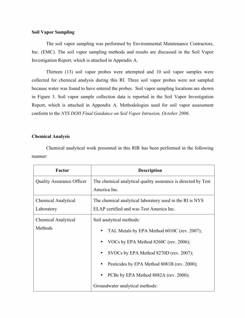
Chemical Analysis
Chemical analytical work presented in this RIR has been performed in the following
manner:
Factor Description
Quality Assurance Officer The chemical analytical quality assurance is directed by Test
America Inc.
Chemical Analytical
Laboratory
The chemical analytical laboratory used in the RI is NYS
ELAP certified and was Test America Inc.
Chemical Analytical
Methods
Soil analytical methods:
• TAL Metals by EPA Method 6010C (rev. 2007);
• VOCs by EPA Method 8260C (rev. 2006);
• SVOCs by EPA Method 8270D (rev. 2007);
• Pesticides by EPA Method 8081B (rev. 2000);
• PCBs by EPA Method 8082A (rev. 2000);
Groundwater analytical methods:
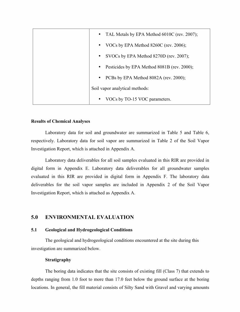
• TAL Metals by EPA Method 6010C (rev. 2007);
• VOCs by EPA Method 8260C (rev. 2006);
• SVOCs by EPA Method 8270D (rev. 2007);
• Pesticides by EPA Method 8081B (rev. 2000);
• PCBs by EPA Method 8082A (rev. 2000);
Soil vapor analytical methods:
• VOCs by TO-15 VOC parameters.
Results of Chemical Analyses
Laboratory data for soil and groundwater are summarized in Table 5 and Table 6,
respectively. Laboratory data for soil vapor are summarized in Table 2 of the Soil Vapor
Investigation Report, which is attached in Appendix A.
Laboratory data deliverables for all soil samples evaluated in this RIR are provided in
digital form in Appendix E. Laboratory data deliverables for all groundwater samples
evaluated in this RIR are provided in digital form in Appendix F. The laboratory data
deliverables for the soil vapor samples are included in Appendix 2 of the Soil Vapor
Investigation Report, which is attached as Appendix A.
5.0 ENVIRONMENTAL EVALUATION
5.1 Geological and Hydrogeological Conditions
The geological and hydrogeological conditions encountered at the site during this
investigation are summarized below.
Stratigraphy
The boring data indicates that the site consists of existing fill (Class 7) that extends to
depths ranging from 1.0 foot to more than 17.0 feet below the ground surface at the boring
locations. In general, the fill material consists of Silty Sand with Gravel and varying amounts
of debris such as brick, concrete, coal, ash, wood, asphalt, glass, topsoil, and roots. Below the
fill are layers of Sand, Sand with Gravel, or Silty Sand with Gravel (Class 3a or 3b) with
varying amounts of cobbles and boulders. Probable bedrock was encountered in boring B-112
at a depth of 13.0 feet beneath the existing ground surface.
Hydrogeology
During this investigation, groundwater was encountered in the test borings at depths
ranging from 11.0 to 13.0 feet beneath the ground surface. These depths correlate to
groundwater levels ranging between elevation +1.6 and elevation +3.6. Groundwater was
encountered in the monitoring wells at depths ranging from 10.3 to 14.3 feet beneath the
ground surface. These depths correlate to groundwater levels ranging between elevation +0.5
and elevation +5.3. A table of water level data for all monitoring wells is included in Table 3.
Groundwater flow beneath the Site is tidally influenced as a result of the adjacent Long Island
Sound.
5.2 Soil Chemistry
Soil samples collected during the RI showed no detectable concentrations of PCBs.
One VOC (acetone) was detected in one sample at a concentration that exceeds the
Unrestricted Use SCO but is well below the Residential Use SCO. All other VOCs detected
were found to be at very low levels, including PCE at a max concentration of 0.0007 ppm.
One pesticide (4,4’-DDT) was detected at a concentration, which slightly exceeded the
Unrestricted Use SCO but is well below the Residential Use SCO. Five SVOCs including
benzo(a)anthracene (max 3.2 ppm), benzo(a)pyrene (max 3.9 ppm), benzo(b)fluoranthene
(max 4.7 ppm), dibenz(a,h)anthracene (max 0.80 ppm), and indeno(1,2,3-cd)pyrene (max 3.1
ppm) exceeded Restricted Residential Use Soil Cleanup Objectives (SCOs) in most shallow
and roughly a quarter of the deep soil samples. These SVOCs are all in a class of compounds
known as polycyclic aromatic hydrocarbons (PAHs) which are commonly found in historic
fill material. Eight metals exceeded Track 1 Unrestricted Use SCOs, and of these metals
arsenic (max of 20.0 ppm), barium (max of 506 ppm), chromium (max of 113 ppm), copper
(max of 382 ppm), lead (max of 3,960 ppm), and mercury (max of 4.9 ppm), also exceeded
Track 2 Restricted Residential Use SCOs. These sampling results, with the exception of two
shallow hotspot areas, one for lead and one for mercury, are consistent with findings in
historic fill material at Sites throughout NYC.
Data collected during the RI is sufficient to delineate the vertical and horizontal
distribution of contaminants in soil/fill at the Site. A summary table of data for chemical
analyses performed on soil samples is included in Table 5. Figure 4 shows the location and
posts the values for soil/fill that exceed the 6 NYCRR Part 375-6.8 Track 2 Soil Cleanup
Objectives.
5.3 Groundwater Chemistry
Groundwater samples collected during the RI showed that dissolved metals including
antimony, cobalt, iron, magnesium, manganese, and sodium exceeded the New York State 6
NYCRR Part 703.5 Class GA groundwater quality standards (GQS). Two SVOCs
(benzo(a)anthracene and benzo(b)fluoranthene) were detected above GQSs in one sample.
Three petroleum-related VOCs were also detected at trace concentrations, but were well
below their GQSs. Groundwater samples showed no detectable concentrations of PCBs or
pesticides. Given that the Site is located immediately adjacent to the Long Island Sound, we
expect that the groundwater below the Site is brackish.
Data collected during the RI is sufficient to delineate the distribution of contaminants
in groundwater at the Site. A summary table of data for chemical analyses performed on
groundwater samples is included in Table 6. Exceedences of applicable groundwater
standards are shown. Figure 5 shows the location and posts the values for groundwater that
exceed the New York State 6 NYCRR Part 703.5 Class GA groundwater standards.
5.4 Soil Vapor Chemistry
Soil vapor samples collected during the RI showed several petroleum and chlorinated
VOCs at generally low concentrations. Acetone (maximum of 89 µg/m3) and carbon disulfide
(maximum of 79 µg/m3) were detected in all samples. Most other detections were generally
less than 10 µg/m3. PCE was identified in 9 of ten soil vapor samples at a maximum
concentration of 12 µg/m3, TCE was identified in two of the ten soil vapor samples at a
maximum concentration of 1.0 µg/m3, carbon tetrachloride was identified in two samples at a
max concentration of 1.0 µg/m3, and 1,1,1-TCA was identified in five samples at a max
concentration of 6.2 µg/m3. None of these chlorinated VOCs were identified in groundwater
samples collected during this RI, and only PCE was identified at trace levels in soil. All soil
vapor concentrations in were reported below the monitoring level ranges established within
the NYS DOH soil vapor guidance matrices. Methane was only detected in one sample at
0.032 percent, which is well below its explosive limit.
The results of chemical testing of soil vapor are discussed in the Soil Vapor
Investigation Report that was prepared by Environmental Maintenance Contractors, Inc.
(EMC). A copy of the report is attached in Appendix A.
5.5 Prior Activity
Based on an evaluation of the data and information from the RIR, disposal of
significant amounts of hazardous waste is not suspected at this site.
5.6 Impediments to Remedial Action
There are no known impediments to remedial action at this property.
Site-Specific Standards, Criteria and Guidance
• New York State 6 NYCRR Subpart 375-6 - Remedial Program Soil Cleanup
Objectives (Section 375-6.8(a) Unrestricted Use Soil Cleanup Objectives and Section
375-6.8(b) Restricted Soil Cleanup Objectives).
• New York State 6 NYCRR Parts 700-706 - Water Quality Standards (June 1998)
• TOGS 1.1.1 - Ambient Water Quality Standards & Guidance Values and Groundwater
Effluent Limitations
• NYSDOH Guidance for Evaluating Soil Vapor Intrusion in the State of New York
(draft October 2004 or subsequent final draft)