RELIGIOUS TOURISM IN THE CROSS-BORDER REGION ROMANIA ... · Vidin district is located in the...
114
RELIGIOUS TOURISM IN THE CROSS-BORDER REGION ROMANIA-BULGARIA GUIDE INVESTING IN YOUR FUTURE! EUROPEAN UNION EUROPEAN REGIONAL DEVELOPMENT FUND
Transcript of RELIGIOUS TOURISM IN THE CROSS-BORDER REGION ROMANIA ... · Vidin district is located in the...

RELIGIOUS TOURISMIN THE CROSS-BORDER REGIONROMANIA-BULGARIA
GUIDE
INVESTING IN YOUR FUTURE!
EUROPEAN UNION
EUROPEAN REGIONAL DEVELOPMENT FUND


3
BU
LG
AR
IA

4

5
VIDIN DISTRICT
Introduction
Vidin district is located in the northwest of Bulgaria, on the border with
Serbia (west) and Romania (northeast). The district has an area of 3,032
km2, representing 2.73% of the total area of the country. Vidin has the
lowest number of inhabitants / km2 compared to other districts in
Bulgaria, the population of the area being 86,927 inhabitants in 2018,
according to Eurostat. The district is structured into 10 municipalities on
the territory of which 7 cities were constituted - the administrative center
is Vidin city located on the Danube river bank.
Vidin district has a rich and turbulent history, considering its strategic and
geographical importance for the consolidation and definition of the
Bulgarian state since the Middle Ages, the territory being a military,
transport and commercial center for over 2,000 years. Thus on its
territory there are numerous archaeological remains, among the most
famous being the Baba Vida Fortress (the only medieval castle in
Bulgaria fully preserved, over 2,000 years old), the Castra Martis
Fortress (built during the Roman and Byzantine periods, centuries I-VI),
the Kaleto Fortress (among the best preserved fortresses in Bulgaria),
the ruins of the Roman city Ratiaria (an important gold trading center).
The Regional History Museum in Vidin is also an important element of
cultural and historical heritage. In the Vidin district numerous pilgrimages
can be made, the most famous places of religious worship located in this
area being Albotina Monastery in the Danube Plain (dug in the rock),
Monastery "The Assumption of the Virgin Mary" (in whose courtyard
there is a spring with curative properties). The district is the spiritual
center of theVidin Metropolis. In the city of Vidin one can also visit the
Cathedral "St. Martyr Dimitar”, the second largest Bulgarian Orthodox
church of national importance.
From the perspective of natural heritage, the Belogradchik Rocks are
the best known tourist objective in the area, being nominated in 2009 in
the campaign for the "Seven natural wonders of the world". Other points
of interest can be the Venetsa Cave, the Lepenitsa Cave (integrated in
an ecotourism route) and the Magura Cave (inside which the largest
exhibition of cave paintings in Europe was discovered).
The Vidin district has many cultural and natural tourist objectives, the
tourism sector having the potential to generate a sustainable economic
growth of this territory.

6
SAINT DEMETRIUS CATHEDRAL
Titular saint: „Holy Martyr Demetrius”
Localization/address: Street Ekzarh Iosif I nr. 2, in the center of Vidin, Vidin district
Access road: D1, then Ring Vidin, Panonia Boulevard, asphalt in very good condition
GPS coordinates: 43.987187 / 43°59'14” N – 22.874447 / 22°52'28” E
Cathedral St. Demetrius is the business card of Vidin. The church is the
second largest in Bulgaria and the third largest in height, measuring 33
meters. The first building was built on a wooden structure, which collapsed
over time, so it was necessary to build a new large church, built between
1885-1926. It was a realization of Antim, the first Bulgarian exarch, and the
construction was made with the efforts of all the believers in the city. Proiectul
apar�ine unui maestru al �colii din Tryavna �i unui arhitect italian. It is a basilica
with three naves, in the form of a cross, with a large interior space. To keep
track of time, one of the bells has a clock built in 1900.
The interior space of the building is divided into three planes. The iconostasis
is an artistic work of the Debar School, with the helf of the famous Philipovci
family, made in 1923. The church is beautifully painted by a team led by artist
Zhelyazkov, from Repin's Russian school. In addition to the icons of the
Bulgarian saints, there are also several Bulgarian national heroes in the holy
place. The painting "Gifts from the Tsar Peter (927-970) to St. John of Rila” is
found only in this church.

7
CHURCH SAINT NICHOLAS
Titular saint: „Saint Nicholas the Miracle doer”
Localization/address: Street Baba Vida nr. 11, on the seafront of Vidin, Vidin district
Access road: D1, then Ring Vidin, Street �tefan Karadzha, very good asphalt
GPS coordinates: 43.988133 / 43°59'17” N – 22.880875 / 22°52'51” E
The church is part of an eparchial complex, next to the Church of St.
Pantelimon, the Cathedral of Vidin and the Mausoleum of the Exarch
Antim. The first church was built in 1799, on the ruins of the old bell
tower, being an annex of the Church St. Pantelimon. The new church
was built under another project in 1926. It is a basilica with three
intersecting naves, with apse and pronave, with two galleries, north and
south, and one to the west. From the outside, the church is impressive,
with a large dome, two towers located symmetrically above the central
entrance, as well as beautiful facades, with round and vaulted windows.
vŒ‡Œ•N–‰@m›™–—–“Œ›„•@›‹@…¢@„››•‡‡@š™ŸŒ†š@™Šœ“„™@„™@›‹™@h™@RPPYN@Œ•@™•–Ÿ„›‡@�„š@†‹œ™†‹@t‹@j“Œ„£’–ŸN@„•‡@y„•’–Ÿ@k™„š›¢œ@fŒ“Œ—–ŸL@p‹Œ“Œ—@s†‹––“L@d…„™@›‹@–‰@”„š›™š@›‹@…¢@”„‡@„™@”œ™„“š@„•‡@Œ†–•š@…„œ›Œ‰œ“@t‹@b™“Œ•N@Œ•@¡†œ›‡@—™–…„…“¢@”–š›@d–™L@mŒ™†“@›‹@nŒ†‹–“„š@s„Œ•›@™—™š•›Œ•Š@�„““L@š–œ›‹™•@›‹@–•@”–š„Œ†@„@„•‡@‰“––™@”–š„Œ†@…„œ›Œ‰œ“@¡›™”“¢@„•@‰Œ•‡@�@†‹œ™†‹@›‹@i•šŒ‡@

8
BABA VIDA FORTRESS
GPS coordinates: 43.992622 / 43°59'33” N – 22.884983 / 22°53'6” E
Address: Street Baba Vida, Danube promenade, Vidin, district Vidin
BU
LG
AR
IA
Baba Vida Fortress is considered to be the most representative historical
monument in the entire region, due to the fact that it is a fortified medieval
fortress that has been preserved almost entirely. The first historical data show
that on this location there was at the beginning a Roman fortification with the
name of Bononia, built for observation. The fortress was then enlarged during
the Byzantine and medieval periods, due to the strategic position that allowed
the control of the traffic on the Danube, the surveillance of the commercial
roads, but also the military defense of the city. The oldest existing walls date
from the tenth century, from the period of the Bulgarian Empire. Baba Vida
Fortress was the residence of Tsar Ivan Stratimir, the founder of the last
Bulgarian dynasty.
The castle has two surrounding walls, an inner courtyard and two outer
courtyards. The interior walls have a height of over 2 meters, being supported
by 9 defense and observation towers, the entire surface occupied by the
fortress covering about 9,500 square meters. During its time under Bulgarian
rule, the fortress was permanently enlarged and strengthened, many of the
constructions and fortifications since then being kept intact to this day. In
1689, under the rule of the Turks, the fortress was modified for the use of
artillery, being also used as a weapon and military storage facility, but also as a
prison. After the liberation of Bulgaria in 1878, the castle became the seat of
military authority, being opened to the public only in 1927, and in 1964 it was
declared a historical monument of national importance, entering the
compulsory circuit of each tourist. The fortress is sometimes used as a setting
for movies, theater, concerts or various artistic representations.
The Konak History Museum
GPS coordinates: 43.989145 / 43°59'21” N – 22.874987 / 22°52'30” E
Address: Street Obstinska nr. 2, Vidin, Vidin district
Located right in the center of Vidin, the building of the current history museum
is a building of particular historical importance, known as "Konak". The
construction, with a remarkable architectural plan, dates from the middle of
the 17th century. During the Ottoman occupation, here was the residence of
the military chief of the city, many of the architectural elements being of
Eastern inspiration. After the liberation of Bulgaria in 1878, the building
became the headquarters of the municipality of Vidin. The building has two
floors and has undergone numerous repairs over time, which is why many of
the original elements have been lost. In 1956, this building was transformed
into a museum, under the name of the Vidin History Museum. In the courtyard
around the building there are some archaeological remains from the Roman
period, most of them found after the excavations from the Ulpia Ratsiaria
Colony, from the fortress of Bononia and from the Roman fortress Martis.
Inside the museum are exhibited several collections of objects, grouped onto
period of time. We find here objects from the Iron and Bronze Age, such as
stone and bronze objects, jewelry remnants and various tools, but also cult
objects. The museum also houses collections from the Roman, Byzantine and
medieval periods, ceramic, metal and silver objects, household items, but also
some documents. Another part of the museum presents some landmarks
from the more recent history of the city, namely the struggles to liberate the
country from the Ottoman rule of 1878.

9
BU
LG
AR
IAETHNOGRAPHIC MUSEUM - CROSS BARRACKS
GPS coordinates: 43.990526 / 43°59'26” N – 22.881406 / 22°52'53” E
Address: Street Knyaz Boris I nr. 26, Vidin, district Vidin
This building is a symbol of the historical heritage of Vidin. It was built
relatively recently, at the beginning of the 19th century, between May
25, 1800 and May 14, 1801, by the order of the then ruler of Vidin,
Pasha Osman Pazvantoglu. The purpose of the building was to be
the seat of the Ottoman military garrison. The building is built of stone
and brick, having a unique cross shape, to facilitate the defense in
case of attack. The walls are massive, the outer ones are 100 cm
thick, and the inner ones are 70 cm. At each of the 4 wings there is an
entrance, the main gate being the one from the north, where there is
a well, for drinking water supply. On the ground floor was the food and
water warehouse, the horse barn and a weapons workshop. Upstairs
were the soldiers' bedrooms and kitchen. After the release of
Bulgaria, the building was used as a court of law. In 1965, after a
complete restoration, the ethnographic museum of the city of Vidin
was arranged inside.
Kaleto Fortress of Belogradchik
GPS coordinates: 43.623747 / 43°37'25” N – 22.676645 / 22°40'36” E
Address: Street Colo Todorov, Belogradchik, district Vidin
The Kaleto Fortress of Belogradchik is one of the most spectacular
tourist attractions in the area. The total area covered by this
fortification is over 10,000 square meters. The first military
construction belonged to the Romans, who in the 1st - 3rd centuries
used the fortress to guard the strategic roads in the area. The Roman
engineers have used with great skill the surrounding rocks and the
configuration of the place to ensure the defense of the whole area.
The highest part of the fortress is known as the Citadel, and here are
traces of defense walls and military buildings dating from both the
Roman Empire and the Middle Ages. This fortress was one of the last
fortresses that fell under the Ottoman occupation at the end of the
fourteenth century. After the conquest, the Turks placed a large
garrison here, which played an important role in defending the
western part of the country and suppressed the periodic revolts of the
Bulgarians.
During the period from 1805 to 1837, the fortress was extended and
rebuilt by the Ottoman regime, with the help of French and Italian
engineers, to allow the use of firearms. The fortress has two gates,
named Vidin and Ni�. In some places, the walls have a base thickness
of about 2.5 meters and between 3 and 15 meters high. Along the
walls there are over 400 openings through which you could shoot
with rifles or artillery. Usually the garrison here numbered about
1,000 soldiers, but during the war the number of defenders could
reach 3,000. Belogradchik Fortress is one of the best preserved
fortresses, being declared a cultural monument of national
importance in 1985.

10
BU
LG
AR
IA THE ROCKS OF BELOGRADCHIK
GPS coordinates: 43.623747 / 43°37'25” N – 22.676645 / 22°40'36” E
Address: Street Colo Todorov, Belogradchik, district Vidin
The rock formations near the village are considered the most famous natural
tourist attractions in Bulgaria. The area where they are spread is very large,
about 30 km long and between 3 and 5 km wide. However, the largest and
most beautiful of these wonderful creations of nature are on the hills on the
outskirts of Belogradchik. Geological studies have shown that at the end of
the Paleozoic this region was invaded by the sea, on the bottom of which were
deposited sand, gravel and clay. The intense reddish color comes from iron
oxide and hydroxide.
As a result of the ice age, this rocky complex rose above the water, following a
natural erosion process that led to the strange rocks we can see today, formed
over millions of years. Through the action of the water and the wind, amazing
shapes, animal figures, human figures or mythological creatures have been
born, and each rock has a legend behind it that tries to explain its shape and
beauty.
Belogradchik Museum of History and Ethnography
GPS coordinates: 43.990526 / 43°59'26” N – 22.881406 / 22°52'53” E
Address: Street Knyaz Boris I nr. 1, Belogradchik, district Vidin
The Belogradchik History Museum is located in the central area of the city, in a
traditional house of historical value, called the Panov House, which presents
architectural features from the Bulgarian Renaissance period. It was built in
1810, and since 1970 it has been transformed into the current museum, now
with over 8,000 objects in storage. On the ground floor there is a collection of
ethnographic elements and traditional household objects, which illustrate the
daily life of the inhabitants of the area.
Upstairs we can admire a few exhibitions of historical objects, covering all
eras, namely objects from the prehistoric period, the Roman period and the
medieval era. A special emphasis is placed on the events carried out during
the Bulgarian war of independence from 1877-1878, in this sense there are
numerous exhibits and documents that illustrate the unfolding of the military
events in this area.

11
Hotel-restaurant Bononia
GPS coordinates: 43.985908 / 43°59'9” N – 22.878338 / 22°52'42” E
Address: Street Bdin nr. 2, Vidin, district Vidin
Hotel-restaurant Anna Kristina
GPS coordinates: 43.987128 / 43°59'13” N – 22.8800887 / 22°52'48” E
Address: Street Baba Vida nr. 2, Vidin, district Vidin
Hotel-restaurant Skalite
GPS coordinates: 43.625265 / 43°37'31” N – 22.687262 / 22°41'14” E
Address: Street Hadji Dimitar nr. 1, Belogradchik, district Vidin
BU
LG
AR
IAMÃGURA CAVE
GPS coordinates: 43.726918 / 43°43'37” N – 22.583816 / 22°35'1” E
Address: on the outskirts of Rabisha village, Vidin district
The M gura cave, located in the village of Rabisha, is one of the 30 ã
caves in the region and is also one of the largest caves in Bulgaria.
The entire interior route is very well arranged for visiting, being
electrified. The main gallery, with a south-north orientation, has a
length of 1,750 meters and together with its 3 main branches, it is
over 2,500 meters long. Inside you can see unique karst formations,
of rare beauty, covered by delicate lace. Here is also the largest
stalagmite in Bulgaria, called the Fallen fir tree, with a height of 11
meters, with a circumference at the base of 6 meters. The largest
room inside is the Triumphal Hall, which has a length of 128 meters,
an opening of 58 meters and a height of 28 meters, covering a total
area of over 5,700 square meters.
Archaeological research began in 1972 and continued until 1996.
Remnants of prehistoric life were discovered in the cave, traces of
settlements dating back to 12,000 years ago, from the Bronze Age
and the Iron Age, as well as various tools and objects of worship
made of stone, ceramic or bone. The most important discovery is that
of a collection of rock drawings, unique to the caves of the Balkan
Peninsula, made from guano. The gallery containing these paintings
has a length of about 300 meters, being structured into several
rooms, passages and openings, in which the primitive people who
lived in this cave made over 700 drawings, representing different
human figures, especially of women, animals, hunting scenes,
religious rituals or war scenes.
Accommodation-restaurant complex Mãgura
GPS coordinates: 43.725067 / 43°43'30” N – 22.590214 / 22°35'24” E
Address: at the exit of Rabisha village, Vidin district
Hotel-restaurant Han Madona
GPS coordinates: 43.597539 / 43°35'51” N – 22.779690 / 22°46'47” E
Address: on leaving Falkovets village, Vidin district

12

13
MONTANA DISTRICT
IntroductionB
ULG
AR
IA
Montana district is located in the northwest of Bulgaria and covers an area of 3,635 km2, representing 3.27% of the country's total area. The district is contiguous to the north with Romania, the border being the Danube river, and to the northwest with Serbia. According to Eurostat, in 2018, the Montana district had a population of 132,214 inhabitants. At the national level, the Montana district is third in number of inhabitants (after Plevna and Vratsa) and area. The administrative and business center of the district is Montana. The district consist of 11 municipalities and 134 settlements.
From the point of view of cultural heritage, in the Montana district there are 600 historical monuments of national and local importance, most of them being archaeological sites (with objects from prehistory, antiquity, the Middle Ages, as well as from the Renaissance period), artistic monuments or public buildings with a special architecture. The most important cultural objectives are: Fortress "Kastra ad Montanezium" (archeological site from the Roman Empire period), The archaeological exhibition "Lapidarium" (archaeological exhibition on local culture from the 2nd to the 3rd centuries), the Ethnographic Museum in the city of Berkovitsa (where you can visit collections dedicated to traditional crafts - e.g. the Berkovska pottery, the Chiprovtsi carpets, the latter being included in the UNESCO World Heritage). From the perspective of religious places of worship, the most famous are the Klisura Monastery (the fourth largest in Bulgaria, built during the second Bulgarian empire - the year 1240; in the monastery there is an icon painting workshop where the techniques of the ancient school of Ohrid are being taught) and the Church "St. Nicholas Chudotvorets" (in Berkovitsa). On the territory of the district there are 138 churches and 4 monasteries, these are among the oldest in the country.
The cultural heritage found in the Montana district is represented by two theaters, a regional library and a regional museum, museum-houses and a municipal museum. There are also 100 cultural centers and numerous art galleries in the district. The most well-known areas in terms of cultural objectives found in or near their territory are Chiprovtsi, Berkovitsa and Lom. In the Montana district, various festivals and fairs are organized periodically, which contribute to increasing its tourist visibility.
The relief of the district is varied, including the fields and plateaus, hills, mountains and valleys. The most important objectives of the natural heritage are: The Berkovitsa marble cave, the waterfalls Zanojene and Rayski kat and the "Kotlya" Rock Massif.
Vârset is the most popular tourist destination in the district of Montana, being the vacation destination of over 55% of the total number of tourists in the district.
14
THE MONASTERY OF ST. JOHN RILSKI OF CHIPROVTSI (CIPROVITI)
Titular saint: „Saint John Rilski”
Location / address: at the entrance to Jelezna village, near Chiprovtsi, Montana district
Access road: D 102, then D 1022, then deviation about 1 km, asphalt very good condition
GPS coordinates: 43.403680 / 43°24'13” N – 22.933457 / 22°56'0” E
BU
LG
AR
IA
Ciprovti Monastery is one of the oldest monasteries in Bulgaria, according to
historical sources, being called Jelezni� Monastery, due to its proximity to the
locality of the same name, on the Ogosta river valley. It was founded in the
tenth century and played an important role in the revolutionary movements for
the liberation of Bulgaria. Throughout the centuries, generations of priests
have been formed here, manuscripts and religious books have been written
and copied. The monastery is linked to the first battles against the oppressing
Turks, being a place of refuge for all the tzars of the Second Bulgarian Empire
from the fourteenth century. Here were deposited the relics of St. John of
Rila, when they were brought from Hungary. The existence of the monastery
is closely linked to the older history of the region, reminiscent of the Thracian,
Roman and medieval times. In the 16th-17th centuries, the local population of
Orthodox and Catholics, grouped around the Ciprovti Monastery, participated
in the battles against the Turks. The monastery witnessed six uprisings
against the Turks, serving as a refuge for the outlaws. For this reason it was
burned six times, but it was redone every time, remaining one of the most solid
landmarks of the Orthodox faith in the past centuries.
The monastery has a very rich library with Slavonic books and manuscripts,
being sought by specialists in the field. Located at the foot of the Balkans, the
monastery complex was last reconstructed in 1876, having a rectangular
shape. The last rehabilitation of the church was made in 1829, of stone, in the
shape of a nave with an apse, a style borrowed from Gothic architecture.
Beside the central gate of the complex are located two apartment buildings
with two floors, the space of the egumen, a tower with ossuary and chapel and
the bell tower, where the remains of some freedom fighters in northwestern
Bulgaria are buried. Above is the sanctuary of St. John of Rila. In the past, in
the complex there were stables and warehouses. The exterior facade of the
church is covered with pictures and inscriptions carved in stone. The
iconostasis is splendid, made by an unknown craftsman, and the icons are
painted by Hristo Encev from Kopriv�ti�a. In the western wing of the monastery
is the chapel of St. Anastasius the Great, made in 1880, with murals
representing local saints. Every year, during the feast of the patron saint
(October 19), a great agape is celebrated in the honor of St. John of Rila. The
entire monastery is restored, with central heating and sanitary spaces. It is a
cultural monument of national importance, inscribed on the list of 100
monuments.

15
BU
LG
AR
IA

16
Chiprovtsi History Museum
GPS coordinates: 43.383742 / 43°23'1” N – 22.879665 / 22°52'46” E
Address: Street Vitosha nr. 2, Chiprovtsi, district Montana
Hotel-restaurant Kiprovets
GPS coordinates: 43.383876 / 43°23'2” N – 22.880202 / 22°52'48” E
Address: Street Ivan Stanislavov nr. 14, Chiprovtsi, district Montana
BU
LG
AR
IA
The history of this museum began in the year 1968, when the
first two collections, the historical and the artistic one, were set
up within the "Probuda" Culture House. On May 20, 1986, on
the occasion of the 300th anniversary of the Chiprovtsi uprising,
the creation of the Chiprovtsi History Museum was announced,
and the already existing collections were transferred to the City
History Museum. Nowadaysthe museum exhibitions are
presented onto sections, located in different thematic rooms:
Metal extraction, Gold School, 17th Century History, Carpet Hall
and Renaissance Art. There is also an ethnographic exhibition,
as well as the only collection in Bulgaria with plants from which
paint for wool and carpets is produced.

17
LOUPSHANSKI MONASTERY
Titular saint: „St. John the Apostle”
Location / address: at the exit of Georgy Damyanovo village, Montana district
Access road: D102, then D1024, asphalt very good condition
GPS coordinates: 43.376843 / 43°22'36” N – 23.020922 / 23°1'15” E
BU
LG
AR
IA
Loupshanski Monastery, dedicated to "St. John the Forward-walker”, is
located in the western part of the Balkan mountains, near the river
Dalgopolska Ogosta. The present buildings are built over an older monastery
from the 14th century. Often burned down and devastated by the Turks, the
monastery was long uninhabited, hence the name of Desert Monastery. In
1850, the monks Dionysius, Gideon and Gherasim began the reconstruction
of the monastery. A monastery school was also opened, and secret meetings
were held in the church between the rulers of the region, one of the
conspirators being the Archimandrite Dionysius, abbott of the monastery.
The entire monastery complex, with the church, the residential and household
buildings, the chapel with the ossuary and the shrine, was created by the
master Lilo from the Slavine School, who has twice visited the Rila Monastery
for this purpose. The monastery church thus became practically a copy of the
one in Rila, being the third largest in the country, with three naves, three apses,
a pseudo-basilica, two lateral chapels and stone reliefs depicting soldiers,
animals, birds. The church, large and imposing, has an iconostasis, a
magnificent sculpted art achievement of the Samokov School, as well as
splendid icons painted by brothers Stanislav and Nicola Dospevski, the
successors of the renowned painter Zaharia Stoianov from Samokov.
Particularly impressive are those with Jesus Christ and the Virgin Mary, made
in 1863 by Stanisalv Dospevski.
The monastery is famous for the icon of the Virgin Mary, a miracle worker, who
saved and healed many people, but also for the armored icon of the Virgin
Mary, found built into an old wall. In the courtyard of the monastery, besides the
marvelous fountain of 1856, ornamented with embossings, there is also the
new church, similar to the old Roman one near the monasteries, as well as the
exhibition of icons.

18
KLISURSKI MONASTERY
Titular saint: "Saints Kiril and Metodiul"
Location / address: fork at D 812, between Spancevtzi and Iagodovo, Montana district
Access road: D81, then D812, then deviation about 2 km, good condition asphalt
GPS coordinates: 43.183361 / 43°11'0” N – 23.205413 / 23°12'19” E
BU
LG
AR
IA
The holy place, located on the hill in the center of the complex,
has the shape of a church with three naves, a crucified tower,
with three apses, a dome with an eight-walled barrel in the
middle, an outer nave and two bell towers on the north and south.
The splendid iconostasis is the work of master Stoiceo Fandakov
from Samocov. From the tenth century until today, the monastery
has served as a true spiritual center in the region.
Repeatedly, it was set on fire, plundered, destroyed and rebuilt by
locals. In the modern era, only in 1867, Ilia Stoyanov from
Dragani�a village, following a vision of St. Nicholas, begins the
restoration of the holy place, managing to involve the local
population in this work.
His successor, Alexandar Damianov from Bercovita, later
became the abbott Antim, being the son of a rich man,
dedicating his life and personal wealth to the development of the
monastery, so that from 1887 to 1890, the church was built.
Supported by the surrounding Orthodox population, he manages
to buy a large number of monastery land. The abbott Antim dies
at the age of 95, after spending 55 years in this monastery. In
1891, the talented painter Nikola Obrazopisov (1828-1925), a
connoisseur of the traditions of Mount Athos, is called to paint
the new icons donated by the founders.
Between 1936-1937, the successor of the Russian painter
Repin, Gospodin Jeliazkov, his daughter Olga and his son-in-law,
prof. Gherghi Bogdanov, paint the place again. Subsequently,
the archimandrite Antep, the current protozoan of the Metropolis
of Vidin, begins extensive work on the infrastructure of the
monastery complex. Visitors can learn about the history of the
monastery by visiting the church museum, which contains
valuable exhibits, photographs, documents, church utensils,
service books and icons.
Here you can also see the ruins and objects of the first Bulgarian
and Metropolitan exarch of Vidin, Antim, as well as those of the
Metropolitan of Vidin, Dometian.

19
rš›„œ™„•›@@p™Œ@s›„“Œn
Coordonate GPS: 43.195515 / 43°11’44” N – 23.197184 / 23°11’50” E
Address: fork at D812, between Spancevtzi and Iagodovo, Montana district
BU
LG
AR
IA

20
CHURCH OF ST. GEORGE THE VICTORIOUS IN VARSHETS
Titular saint: „Saint George”
Localization/address: Street Republicii no. 31, downtown Vrashets, Montana district
Access road: D81, then D812, good condition asphalt
GPS coordinates: 43.198565 / 43°11'55” N – 23.290062 / 23°17'24” E
Hotel-restaurant ATA SPA
GPS coordinates: 43.186530 / 43°11'11” N – 23.281487 / 23°16'53” E
Address: Street Dr. Constantin Penev nr. 1A, Varshets, district Montana
BU
LG
AR
IA
The Church of St. George the Victorious is found on the main street, close to
the centre of the locality. It was built in 1902, being a cross basilica, with three
domes, with open porch and brick masonry on the facade. It was consecrated
in 1906. The iconostasis is the work of an unknown local craftsman, and
inside are still old icons from the 17th and 18th centuries. The newest ones
are made by the academic Ivan Stefanov. Interesting are the four chapels and
two candlesticks, brought from Jerusalem and Constantinople. In 1992, the
church was painted, and in 2018, it was completely renovated. At present,
the church is run by the theologian doctor Petko Baldzhiev. The settlement is
visited by many believers, due to the fact that the town of Vrashets is a
mountain resort highly sought after by tourists.

21
CHURCH OF SAINTS KIRIL AND METHODIUS FROM MONTANA
Titular saint: "Saints Kiril and Methodius"
Localization/address: Street Kiril si Metodiul, intersection with Cherkovna Street,
downtown Montana, Montana district
Access road: D1, D102, then Street Kiril si Metodiul, good condition asphalt
GPS coordinates: 43.404474 / 43°24'16” N – 23.221313 / 23°13'16” E
BU
LG
AR
IA
The church is located in the old part of the city, at the foot of
Montanezium fortress, in an urban complex that includes a Roman
necropolis, an Orthodox church and a Jewish synagogue, a few
mosques, a school, Roman and Turkish baths. After the withdrawal of
the Russian Temporary Administration from Bulgaria in 1879, the
local government adopted the proposal that an Orthodox church be
erected instead of a mosque. So one night, the Bulgarian inhabitants
demolished the minaret and transformed it into an Orthodox church.
The old church on the slope, with a low and flat ceiling, no longer
corresponded to the needs of the city, so the edifice was rebuilt from
the wall, with two towers, with large, spacious spaces, being
consecrated in 1898. In the following years the bell tower with four
bells was built, the administrative building and the monastery garden
with exotic plants. Subsequently, it was restored several times to
finally reach its current form. The iconostasis dates from 1879 and
was made by craftsmen from the Samokov School. The church has
some icons from 1879, painted by the renowned craftsman Hristo
Encev, who studied in Florence, being born in the town of Koprivsti�a.
The whole church is painted by prof. Ilia Pefev and by Apostol
Apostlov, artists trained at the Debar School.

22
Fortress Castra ad Montanezium
GPS coordinates: 43.402111 / 43°24'7” N – 23.217449 / 23°13'2” E (at the entrance) or
43.400419 / 43°24'1” N – 23.220806 / 23°13'15” E (for the parking)
Address: Street Izvora nr. 91, Montana, district Montana
BU
LG
AR
IA
The fortress Castra ad Montanesium is located in the northwestern part of the
city, on Kaleto hill. In the area, numerous prehistoric archaeological evidence
has been discovered about the first inhabitants of the stone age and the
copper age. Later, ancient Thracian tribes lived on the hill until the 1st century
BC. From the constructions made by them, there were traces of stone walls,
which protected them against the attackers, having a thickness of more than
one meter wide. Attracted by the rich deposits of various ores in the area,
including gold, located along the Ogosta River, at the end of the first century
BC, the place was conquered by the Romans. They gave the name of the city,
which comes from the Latin word Mons, meaning mountain.
‰™›Œ“Œ›¢N–‰@Š–‡@›‹@d„£‹‡…–ŠL@–™@p™œ•@–‰@Š–‡@›‹@›–@‡‡Œ†„›‡@‡„¢L@›‹Œš@›–@—™š™Ÿ‡@š„•†›œ„™¢L@—„Š„•@„@Œ•›–@›™„•š‰–™”‡@Œš@…œŒ“‡Œ•Šš@…„™™„†’š@›‹@–‰@–•@„•‡@kœ›“–ŸŒ›š„L@†„““‡@š››“”•›@„@…œŒ“›@s“„Ÿš@t‹@‡š›™–¢‡N@�„š@‰–™›™šš@›‹@s“„ŸšL@›‹@„•‡@aŸ„™š@›‹@–‰@Œ•Ÿ„šŒ–•@›‹@�Œ›‹@†•›œ™¢L@vi›‹@›‹@–‰@•‡@›‹@a›@a—–““–N@„•‡@dŒ„•„@‡Œ›Œš@›‹@›–@‡‡Œ†„›‡@š„•†›œ„™¢@š›–•@–“‡@„•@Œš@‹Œ““@›‹@–‰@‰––›@›‹@a›@adN@†•›œ™¢@S™‡@›‹@‰™–”@›™Œ…š@g–›‹Œ†@›‹@–‰@™„Œ‡š@›‹@„Š„Œ•š›@…œŒ“›@�„š@‡‰•šL@–‰@�„““š@›‹Œ†’@„•‡@†‹œ™†‹@…„™™„†’šL@Œ•†“œ‡‡@�‹Œ†‹@m–•›„•šŒœ”L@„‡@c„š›™„@‰–™›™šš@t‹@™œ“N@r–”„•@œ•‡™@™„—Œ‡“¢@‡Ÿ“–—‡@†™„‰›š@„•‡@„Š™Œ†œ“›œ™@Š–“‡L@„•‡@–™š@–‰@¡—“–Œ›„›Œ–•@t‹@e”—Œ™N@›‹@–‰@™š›@›‹@�Œ›‹@™–œ›š@›™„‡@›–@“Œ•’‡@�„š@†Œ›¢@t‹@›™––—šN@”Œ“Œ›„™¢@—™”„••›@�™@›‹™@�‹™@mŒ£Œ„L@l–�™@–‰@—™–ŸŒ•†@›‹@–‰@†Œ›¢@†•›™@›‹@…†„”@m–•›„•„@
Montana Regional History Museum
GPS coordinates: 43.406171 / 43°24'22” N – 23.226815 / 23°13'36” E
Address: Street Graf Ignatiev nr. 3, Montana, district Montana
Initially this museum was created as a museum of the Revolution of
September 1951, but with all the Communist accent from the beginning, the
museum has a collection consisting of various valuable exhibits, representing
the rich history of the entire region. Since 1991, the institution has been
transformed into a true historical museum. Inside, the museum has the
following sections: archeology, ethnography, history of Bulgaria centuries
XIV-XIX, modern history, current history and cultural heritage. The museum
presents to the tourists valuable discoveries from the Neolithic era, the
Thracian age, the Roman era, the Middle Ages and the Renaissance period of
Bulgaria. A special value is represented by the Yakimov silver treasure, a copy
of which is displayed here. The museum's exhibits are placed in various
locations in the town of Montana, such as the Exhibition Hall, Mihailov House,
the Lapidarium Archaeological Exhibition and the Ancient Fortress.

23
LAPIDARIUM OUTDOOR EXHIBITION
GPS coordinates: 43.403955 / 43°24'14” N – 23.221906 / 23°13'19” E
Address: Street Dimitar Talev, in the park near Kiril and Methodius Church, Montana, Montana district
Hotel-restaurant Jithomir
GPS coordinates: 43.408911 / 43°24'32” N – 23.223893 / 23°13'26” E
Address: Street Jeravitsa nr. 1, Montana, district Montana
Hotel-restaurant Vesta
GPS coordinates: 43.408684 / 43°24'31” N – 23.219929 / 23°13'11” E
Address: Street Tsar Samuil nr. 10, Montana, district Montana
Hotel-restaurant Ring
GPS coordinates: 43.389178 / 43°23'21” N – 23.216836 / 23°13'0” E
Address: on the shore of Lake Ogosta, Montana, Montana district
BU
LG
AR
IA
The Lapidarium is an open-air archaeological exhibition of epigraphic
monuments from the Roman era. A number of 56 monuments discovered in
the old Roman settlement of Montanesium (present-day Montana) are located
in the middle of the park in Popska Garden. The marble inscriptions represent
extremely valuable testimonies for the culture and history of this region from the
2nd-3rd centuries AD. They are the only written sources for this provincial
Roman city and provide information about the ancient cult for the goddess
Diana, who was the protective goddess of Montana, the god Apollo, Esculap,
Hygiea, Latona, Silvan and other deities, but also important historical data
about the visitors here, as well as the military units stationed in this garrison.
The inscriptions carved in stone and marble also speak of the glory of the
Roman emperors, of the rulers and governors of the province of Lower Mizia,
as well as of the fighting facts of some military and civilians.

24
VRATSA DISTRICT
Introd tionucB
ULG
AR
IA
šœ——“Œ™N“†›™Œ†Œ›¢@•„›Œ–•„“@”„Œ•@›‹@…Œ•Š@–—™„›šL@p“„•›@p–�™@nœ†“„™@k–£“–‡œ¢@›‹@•–™›‹L@›‹@›–@‡Œš›™Œ†›L@›‹@i•@s–‰Œ„N@†„—Œ›„“@›‹@‰™–”@’”@QQV@“–†„›‡@v™„›š„L@–‰@†Œ›¢@›‹@…Œ•Š@†•›™@„‡”Œ•Œš›™„›ŒŸ@„•‡@œ™…„•@”„Œ•@›‹@”œ•Œ†Œ—„“Œ›ŒšL@QQ@Œ•›–@‡ŒŸŒ‡‡@Œš@‡Œš›™Œ†›@›‹@ŸŒ�L@–‰@—–Œ•›@›™™Œ›–™Œ„“@„@f™–”@Œ•‹„…Œ›„•›šN@QVULVTU@�„š@“Ÿ“@‡Œš›™Œ†›@„›@™—–™›‡@—–—œ“„›Œ–•@›‹@eœ™–š›„›L@›–@„††–™‡Œ•Š@RPQXL@i•@†–œ•›™¢N@›‹@–‰@›™™Œ›–™¢@›–›„“@›‹@–‰@SNRVE@™—™š•›Œ•Š@’”RL@SLVQY@Œš@šœ™‰„†@i›š@š–œ›‹IN@›‹@H›–@”–œ•›„Œ•š@p“„•Œ•„@s›„™„@›‹@„•‡@•–™›‹I@›‹@H›–@™ŒŸ™@d„•œ…@›‹@…›�•@bœ“Š„™Œ„L@•–™›‹�š›™•@Œ•@“–†„›‡@Œš@‡Œš›™Œ†›@v™„›š„@
Numerous buildings of cultural and historical heritage are found in Vratsa
district. Some of the most well-known cultural buildings are the "Radetski"
National Naval Museum (the only floating museum in Bulgaria), the Kaleto
archaeological complex (it has a history of more than 70 centuries; at the site
were discovered the ruins of two fortified settlements from the end of the
copper-stone and eneolite era, dated between the end of the 5th millennium
and the first half of the 4th millennium BC), the Ivan Zambin Museum-House
(with exhibits presenting the artistic trades and traditional trades in the Vratsa
area). The most important archaeological discoveries made in Vratsa district
come from the Thracian period.
As for the religious buildings on the territory of Vratsa district, the largest and
most impressive is the Cherepish Monastery which is located on the
picturesque Iskar River Gorge - the monastery is classified as an objective of
cultural heritage of national importance and is dated in the 17th century.
Other monasteries in the Vratsa district that can be integrated into a tourist
circuit are the Strupetski Monastery "St. Ilie" and the Gradeshnitsa Monastery.
In the city of Vratsa are located the headquarters of the Metropolitan of Vratsa,
as well as the Cathedral "St. Apostles” (built in 1898).
The district has a rich natural heritage, among the best known objectives
mentioning Vrachanski Natural Park, Vrachanski Karst Reservation, Ledenika
Cave of international importance (which houses 53 species of animals and
inside which cascades have been formed), Vratsa Gorges nearby Vratsa city,
Skaklya waterfall (141 m high), Ritlite rock formations (near Cherepish
Monastery).
From the perspective of tourism development, the Vratsa district can
accommodate different types such as speleological, adventure, rural, cultural
or religious tourism.

25
IVAN PUSTI MONASTERY
Titular saint: „Saint Ivan Pusti”
Localization/address: deviation from D1 a few km. from the entrance in the city of Vratsa, Vratsa district
Access road: DN1, then unmarked road, asphalt relatively good condition, steep uphill slope
GPS coordinates: 43.243510 / 43°14'36” N – 23.463407 / 23°27'48” E
BU
LG
AR
IA
Located not far from the road that connects Vratsa with Montana, the
monastery is part of the spiritual centers on Mount Vico, at the foot of the
Balkan mountains. Built around an ancient Thracian sanctuary, erected several
millennia before Christ, the monastery was the spiritual center of the medieval
fortress Kasina. It was destroyed several times by the Turks, being restored as
today between 1894-1928. There was a school here to educate the poor
children in the area. Over time, it bore many names: Kasinets Monastery, St.
John the Theologian, St. John of Rila, Pustii. In 2008, the monastery was
renovated again. The church is a basilica with a nave, with the dome covered
with split plates and six buttresses to the north and south.
Around the monastery there are caves where monks lived. In one of them lived
St. John of Rila, the heavenly protector of Bulgaria and Europe, and the walls of
this cave there are still paintings. The icons and iconostasis were made by Todor
Manyov, from the Treyava School. In the mural painting there are three distinct
layers: from the eleventh century, from the sixteenth century and from the
nineteenth century.
In the 17th century, the craftsmen Nikola, Pala and Kostadin from Chiprovtsi,
representatives of the famous Golden Crafts School in Chiprovtsi, came to
work here. The golden cross is kept, with colored stones and with the two lions
and the inscription "for the Kasinets Monastery, craftsmen Nikola and Pala
from the village of Kiprovtsi [...] the bishop of Târnovo, Gavriil, 1612", but also
two gospel covers. This gold workshop has made an important contribution to
the development of crafts in the last 200 years. During the Renaissance, the
monastery was not only a craft center, but also a great literary and spiritual
center.

26
CHURCH SOFRONII VRACHANSKI IN VRATSA
Titular saint: "Ascension to Heaven"
Localization/address: Street General Leonov nr. 3, downtown Vratsa, district Vratsa
Access road: D15, then D 1002, very good asphalt
GPS coordinates: 43.202564 / 43°12'9” N – 23.550727 / 23°33'2” E
BU
LG
AR
IA
The church ispart of a museum complex, together with the Ethnographic
Museum and the Museum of carriages and traditional houses from the
Renaissance Period. It dates from 1848, being built over an older church
and is the oldest religious monument in the locality. Through its entire
existence it has been a center of great importance for the spiritual and
political life of Vratsa district, and its name is linked to remarkable
Bulgarian personalities: Vasil Levski, Sofronii Vrachanski, Paisii
Hilendarski. The building is shaped like a basilica with three naves, on
the west side there is the bell tower. The iconostasis and the royal gates
represent an exceptional work of art belonging to the famous Debar
School. The icons are painted by Anton Stanishev and the great master
of Samokov, Dimitri Zograf.
In 1989, on the occasion of the 250th anniversary of the birth of the
Renaissance educator, Bishop Sofronie Vrachanski of Vratsa, by a
decision of the Diocesan Council of the Bishopric of Vidin, the church
was declared a "Memorial monument to Bishop Sofronie of Vratsa
(Vrachanski)". Sofronie Vrachanski is the spiritual protector of Vratsa.
After the major restoration of 2002, every year on June 2, a service
commemorating Hristo Botev and the fallen heroes for the freedom of
Bulgaria takes place. In the church is organized an exhibition with the
theme of ancient Bulgarian art from the Vratsa region, consisting of
icons, church objects and wood carvings. The complex is managed by
the Vratsa Regional History Museum.

27
ST. NICHOLAS CHURCH IN VRATSA
Titular saint: "Saint Nicholas"
Localization/address: Boulevard Hristo Botev no. 1, Vratsa, Vratsa district
Access road: D15, then D 1002, through Boulevard 2 Iunie, asphalt very good condition
GPS coordinates: 43.200297 / 43°12'1” N – 23.549865 / 23°32'59” E
CHURCH OF SAINTS CONSTANTINE AND ELENA OF VRATSA
Titular saint: "Saints Constantine and Elena"
Localization/address: Street Petropavlovska nr. 84, Vratsa, district Vratsa
Access road: D15, then D 1002, then Grancharska street, asphalt in good condition
GPS coordinates: 43.201252 / 43°12'4” N – 23.546703 / 23°32'48” E
BU
LG
AR
IA
Located in the city center, this church was built between 1865-1867. It
is called metropolitan because inside is buried one of the metropolises
of Vratsa. Inside it has beautiful frescoes and wonderful icons painted by
Stanislav Dospevski from the Samokov School and Zhelyazkovi Kashev.
The iconostasis is the work of a master from the Debar School, Anton
Stanishev. It has the shape of a large basilica, with a three-storey bell
tower, on the dome being painted Jesus Christ the Pantocrator, and on
the pendants - the four evangelists.
The locals call this settlement "St. �arevi”, in worshiping the St. Emperor
Constantine and his mother Elena. The present church was built on the
site of an older one, dating from the 16th century, which was dug in the
ground. The new church was built between 1910-1915, based on a
project of the architect Pencho Koichev, famous at the time, also

28
CATHEDRAL OF SAINT APOSTLES IN VRATSA
Titular saint: "Apostles Peter and Paul"
Localization/address: Boulevard Hristo Botev nr. 45, downtown Vratsa, district Vratsa
Access road: D15, then D 1002, then Ivan Vazov street, good condition asphalt
GPS coordinates: 43.205744 / 43°12'10” N – 23.547790 / 23°32'57” E
BU
LG
AR
IA designing the Pleven mausoleum, courts, railway stations and many
other buildings. The building is a triple paved basilica, with a transverse
axis, with two bell towers above the pronaos, with a dome in the central
body and apse. The facade is built in neoclassical style. Iconostasul este
din zid, iar sculptura în lemn este f�cut� la Vidin. The icons are made in
Byzantine Orthodox style, with western influence. It is a typical urban
church, with a spacious courtyard and a lot of tranquility. The church is
located in the center of the town, close to the regional library "Hristo
Botev".
The church is located right in the center of Vratsa. Built on the site of an older
church from the 17th century, it is the largest and most imposing church in the
city. It has the shape of a large basilica with three naves, three apses and a
dome with eight walls. The three altars inside are dedicated to Paisie
Hilendarski of Hilandar and the Holy Sophronie of Vratsa (Vrachanski). The
painting is frescoed, and the iconostasis and the episcopal chair are adorned
with floral ornaments and decorative motifs with animals. A beautiful wood
carved crucifix can be found on the pulpit. It is designated a cathedral for the
Metropolitan of Vratsa, where the solemn liturgy is celebrated.

29
BU
LG
AR
IA

30
Sofronii Vrachanski Ethnographic Complex
GPS coordinates: 43.202564 / 43°12'9” N – 23.550727 / 23°33'2” E
Address: Street Dimitraki Hadjitoshev nr. 12, Vratsa, district Vratsa
Vratsa Regional History Museum
GPS coordinates: 43.200981 / 43°12'3” N – 23.547608/ 23°32'51” E
Address: Boulevard Hristo Botev no. 2, Vratsa, Vratsa district
BU
LG
AR
IA
The ethnographic complex is part of the Regional History Museum in Vratsa
and includes an architectural and ethnographic exhibition created between
1972 and 1987. It is located in the center of Vratsa, between three traditional
Bulgarian Renaissance houses. These buildings are declared architectural,
historical and cultural monuments. Upon entering the complex, visitors will
discover the impressive statue of Sofroniy Vrachanski, made by sculptor Krum
Damyanov. Inside the museum there are some collections of great value from
the point of view of popular traditions, such as peasant tools, household and
ceramic objects, folk costumes, carpets and other fabrics.
Old handicrafts characteristic of this region, such as goldsmithing, viticulture,
winemaking, silverware and silkworm growing are presented in Ivan Zambin's
house. There is also an exhibition dedicated to the founder of the band in
northwestern Bulgaria, Diko Iliev, as well as a collection of carriages. In the
Dimitraki Hadjitoshev house we can see a restoration of a house from the
middle 19th century. The "Children's World" exhibition from the late 19th and
early 20th centuries is hosted in Grigoriya Naydenov's house.
The museum was founded in 1953 and is one of the 100 national tourist
attractions of Bulgaria. The exhibitions are presented onto sections in
separate rooms, which follow different stages of the region's development. In
the Prehistory hall, ceramic objects, household items, work tools and
weapons are exhibited, from the earliest times of antiquity to the Roman era.
The Antiquity Hall presents artifacts from the early Roman and Byzantine
times (cent. I-VI). In the Middle Ages hall are displayed old Bulgarian jewelry
typical for the Bulgarian Middle Ages (7th-14th centuries), painted icons,
amulets, silver tabernacles for holy relics, household items and traditional
tools. In the Thracian Treasures hall you can admire the gold and silver jewelry,
objects of value found in the Vratsa region, such as the Rogozen treasure, the
mosaic in the village of Galatin, etc. Valuable copies of the School of
Literature, Iconography and the School of Goldsmiths are presented in the
Bulgarian History room from the cent. XV-XIX. The exhibition dedicated to the
legendary military troops of the revolutionary poet Hristo Botev (1848-1876)

31
Hotel-restaurant Hemus
GPS coordinates: 43.20200 / 43°12'7” N – 23.548685 / 23°32'55” E
Address: Boulevard Hristo Botev no. 1, Vratsa, Vratsa district
Hotel-restaurant Chayka
GPS coordinates: 43.191503 / 43°11'29” N – 23.537166 / 23°32'14” E
Address: when exiting the town on D 1002, Vratsa, Vratsa district
Okolchitsa peak
GPS coordinates: 43.154236/ 43°9'15” N – 23.584046 / 23°35'2” E
Address: when exiting Vratsa, towards the village Pavolce, deviation D1004, Vratsa district
The Citadel Mezdra archaeological complex
GPS coordinates: 43.139870 / 43°8'23” N – 23.704888 / 23°42'17” E
Address: exiting the town of Mezdra, deviation from D1, Mezdra, Vratsa district
BU
LG
AR
IAis organized in the Botev Hall. The Rainbow stone room contains
samples of minerals, precious and semi-precious stones, fossils of flora
and fauna. The economic, political and cultural development of the
Vratsa region until 1918 is presented in the New History Hall.
Mount Okolchitsa is probably Bulgaria's most treasured historic place. It
is the place where the army of revolutionaries led by Hristo Botev fought
heroically against the Ottoman army and not far from this place, Hristo
Botev himself died in battle. The peak has a height of 1048 meters, and
here is built a memorial monument, marked by a huge cross, erected in
1926, with a height of over 25 meters. At the base of the cross there is a
chapel dedicated to Saint George. Every year, on June 2, there is an
impressive pilgrimage involving thousands of people who want to honor
the memory of the great Bulgarian revolutionary and his struggle for
independence.

32
Ritlite rocks
GPS coordinates: 43.107229 / 43°6'26” N – 23.624721 / 23°37'29” E
Address: on the banks of the Iskar River, in Liutibrod village on DN 16, Liutibrod village,
Vratsa district
BU
LG
AR
IA The fortified complex called Citadel is located on a natural protected hill,
located where the main commercial roads intersect, used since long ago. The
area of the Iskar River is inhabited since the end of the Stone Age and the
beginning of the Copper Age, respectively the second half of the 5th century
BC. After these prehistoric populations, who lived in the first known historical
period of the area, the ancient Thracians were established here. In the I
century the place was conquered by the Roman Empire, and in the seventh
century, with the great migration of the peoples of Asia, came here the Slavs,
and later the Bulgarians of Asparuh.
In the eleventh century, the Byzantine emperor Vasile the Great conquered the
northwestern Bulgarian lands. The area was then included in the Ottoman
Empire for several centuries. In 2013, the entire complex is restored and
tourist routes are built. You can see the remains of the fortified settlements of
different times, the "Sanctuary of the Tour", a pagan worship center from the
3rd century. In a permanent exhibition hall are exhibited objects and
archaeological discoveries from the 5 historical periods and a model of the
Roman fortress "Kaleto", dating from the 2nd-5th century. In a separate
building are the handicraft workshops, the information center and the
souvenir shop.
Ritlite is a natural attraction, part of the territory of the "Vrachanski Balkan"
Natural Park, located on the rocky slope above the Lyutibrod village, on the
left bank of the Iskar River. This wonderful work of nature consists of four
almost parallel vertical walls, with a length between 200 and 500 meters and a
thickness between 3-7 meters. The rock isformed 120 million years ago from
durable limestone, from the deposits on the seabed that covered these areas
and formed by folding the Alps-Himalayan mountain range. Similar
formations exist on the opposite side of the river, but they are smaller in size.
Legend has it that long ago there was a massive iron door that closed the path
to the old Bulgarian city of Serdika. The objective derives its name from the
fact that arrangement of the rocks looks like the side walls of a cart drawn by
ritli oxen. Since 1938 these rock formations have been included in the
Register of protected territories and protected areas in Bulgaria.

33

34

35
PLEVEN DISTRICT
IntroductionB
ULG
AR
IAPleven district is located in the north central part of Bulgaria, in the
geographical area of Mizia, in the middle of the distance between the
Danube river and the Stara Planina Mountains. The district covers an
area of 4,653 km2, representing 4.19% of the total area of the country.
According to Eurostat, in 2018, in the Pleven district there was a
population of 244,209 inhabitants. The district is composed of 11
municipalities. The main administrative center of the area is the city of
Pleven (the seventh largest nationally, located approximately 100 km
from the capital Sofia).
From the point of view of cultural heritage, 400 historical and cultural
monuments of local and national importance are registered in the Pleven
district.
Among the most well-known cultural heritage objectives we can find:
Panorama building "Plevenska epopeya 1877-1878" (built in 1977 for
the 100th anniversary of the liberation of Pleven from Ottoman
domination), "Storgoziya" Fortress (where the ruins of a fourth-century
Christian basilica were discovered), the ruins of the Roman city Ulpiya
�skus (located on the route of a bicycle touring circuit), the Nikopol
Fortress (the most important fortified citadel during the Second
Bulgarian Empire). The archaeological discoveries of the Pleven district
date from prehistoric, Thracian, ancient, Middle Ages. From the point of
view of religious places of worship, there are numerous churches and
monasteries in the district, the most famous being Skalna tsarkva „St.
Stephen "(former monastery complex from the X-XI century, at present
there is only one church carved in the rock; on the walls of the rocks one
can admire Christian frescoes dating from the III-IV centuries).
The natural heritage of the Pleven district includes many sights that can
be visited, the most known being: Park "Kaylãka" (with an area of 10 ha,
located near Pleven city), Persina Natural Park (the only natural park in
Bulgaria placed along the Danube river), Chernel�� canyon (within which
a tourist route has been arranged for ecological visits), the "Kupenite"
rock formations (near which the Skoka waterfall and Kaleto forest park
can be visited).
The Pleven district has numerous cultural and natural tourist objectives
for practicing cultural, religious, spa, sports etc.

36
CHURCH OF SAINTS PETER AND PAUL OF NIKOPOL
Titular saint: "Saints Peter and Paul"
Localization/address: street parallel to Vasil Levski street, in the center of Nikopol,
district Pleven
Access road: D34, then the local road parallel to D52, relatively good asphalt
GPS coordinates: 43.704653 / 43°42'16” N – 24.896127 / 24°53'46” E
BU
LG
AR
IA
The church dedicated to the Apostles Peter and Paul in Nicopol is known by
the locals as "the small monastery". Situated at the base of the city's
fortification, the church is a medieval building, probably built somewhere
between the 13th and 14th centuries, certainly existing during the Second
Bulgarian Empire. It first appeared in the historical references in 1871, in a
record of Felix Kanitz, who notes that it was used at one time as the cathedral
of the local Catholics. In another historical writing by George Bals in 1914, the
church is presented as being already in ruins. It is only in 1927 that it is
declared a historical monument. It is a small building, about 10 x 7 meters,
with the entrance on the south side of the nave. The inner nave of the church
is shaped like a cross. The exterior is made of false red brick arches and white
stone. Unfortunately, the state of construction is not very good, the western
part is almost completely ruined.

37
Hotel-restaurant Gold
GPS coordinates: 43.701660 / 43°42'6” N – 24.895055 / 24°53'42” E
Address: deviation from Vasil Levski street, Nikopol, Pleven district
THE CHURCH-MAUSOLEUM OF ST. GEORGE THE VICTORIOUS IN
PLEVEN
Titular saint: „Saint George”
Localization/address: Renaissance Square, in the center of Pleven, Pleven district
Access road: E83, then D35, then Kiril si Metodiu street, towards the center of
Pleven, Pleven district, asphalt very good condition
GPS coordinates: 43.407924 / 43°24'28” N – 24.619368 / 24°37'9” E
BU
LG
AR
IA
Built in memory of the Russian-Turkish Liberation War of 1877-1878,
the Sf George Chapel of Orthodox Rite honors the memory of the fallen
soldiers in the 1878 siege of Plevna. The remains of the 31,000
Russians and 7,500 Romanians are buried in the mausoleum crypt. The
mausoleum was built in 1903-1907, for the 30th anniversary of the
liberation of Bulgaria. The project is elaborated by the architect Penceo
Koicev, and the iconostasis is the work of the painters Ivan Markvichka
and Anton Mitov. The chapel has a Bulgarian-Byzantine style, with cross
domes. It has a central dome 24 m high and four more side domes. The
facade is built with horizontal brick and stone belts on an area of 452
square meters. The chapel is part of the 100 national monuments of
Bulgaria.

38
THE CHURCH OF SAINT NICHOLAS IN PLEVEN
Titular saint: "Saint Nicholas"
Localization/address: Stambolov Square, in the center of Pleven, Pleven district
Access road: E83, then D35, then Ruse Boulevard, then Dimitar
Konstantinov street, Pleven, Pleven district, very good asphalt
GPS coordinates: 43.412827 / 43°24'46” N – 24.616626 / 24°36'60” E
THE HOLY TRINITY CHURCH IN PLEVEN
Titular saint: „Holy Trinity”
Localization/address: Street San Stefano, no. 7, in the center of Pleven, Pleven district
Access road: E83, then D35, then Boulevard Hristo Botev, then Shipka Street, Pleven,
Pleven district, very good asphalt
GPS coordinates: 43.404925 / 43°24'17” N – 24.620909 / 24°37'15” E
BU
LG
AR
IA
It is located in the city center, near the Theater Square and near the Tsar
Osvoboditel Museum House. It is a valuable monument of Christian
architecture, being built on the site of a 13th century chapel, built by traders
from Dubrovnik. In 1834 a new place of worship was built, in the form of a
basilica with three naves. Important moments from the struggle for church
and national independence are linked to its name. The iconostasis and
archery throne, as well as icons of the painter Demetrius Zograf are
preserved. It has the largest collection of icons, 68 pieces, belonging to the
Samokov School of Painting.
Until 1870, in place of the church Holy Trinity there was a small old church and
a school. The desire of the entire society in the city was to have a new place of
worship, so between 1893-1898, the architect Vyachelslav Gavarda made a

39
SAINT PARASCHEVA CHURCH IN PLEVEN
Titular saint: „Saint Parascheva”
Localization/address: St. Parascheva Street no. 1, in the center of Pleven, Pleven district
Access road: : E83, then D35, then Boulevard Georgi Kochev, then Grenaderska street,
then Petko R. Slaveykov street, Pleven, Pleven district, asphalt very good condition
GPS coordinates: 43.415828 / 43°24'57” N – 24.617164 / 24°37'1” E
BU
LG
AR
IAnew project, and the construction was done by the entrepreneur Ivan
Okoliyski of Tryavna, under the patronage of the town hall. The
construction was completed in 1912, resulting in a tall, massive church
made of stone and brick, in the form of a majestic basilica with three
naves, an apse and pronaos, and three domes. The columns in the
nave are of Roman origin. The iconostasis is high, and the icons come
from Galicnik (Macedonia) school masters Danail Nestorov, his cousin
Oventiy Isachev, Aleks Vassilev and Adolf Sedov. The interior was
painted by prof. Iliya Pefev, also descendant of the masters of the
Debar School, between the years1940-1946.
The first church dedicated to Saint Parascheva has been erected since
1523, being a wooden construction, next to a monastery school
attested in 1857. The building was rebuilt between 1870-1879 and
transformed into a basilica with three naves, a nave supported by three
old columns and two domes, with an ante-temple and two side spaces,
the execution being entrusted to craftsmen belonging to the Triavna
School. The church was consecrated by the first Bulgarian exarch,
Antim I. The icons were donated by artisans from the region, and the
mural icons were painted by the painter Serbezov. There is a Sunday
school for children and a center for social activities near the church.

40
sociale.
Museum of the Epic Panorama 1877
GPS coordinates: 43.398876 / 43°23'56” N – 24.607181 / 24°3'25” E
Address: Skobelev Park, Pleven, Pleven district
BU
LG
AR
IA
This unique museum in Bulgaria was raised in honor of liberating Bulgaria
from Ottoman rule. Construction began on January 19, 1977, and the official
opening took place on December 10, 1977, exactly 100 years after the
liberation of Pleven. The authors of the architectural design are the architect
Plamena �aceva and its colleague Ivo Petrov.
The museum is built right on the battlefield, in the Skobelev Museum-Park.
The Panorama Museum is part of the monuments built in memory of the
Russians, Romanians and Bulgarians who died in the Russian-Turkish
liberation war and is included in the 100 national tourist objectives.. The
building is shaped like a cone trunk, framed by four stylized bayonets. A
bayonet ring symbolizes the city blockade, and the three horizontal rings
represent the three attacks on the town of Pleven. The museum is organized
into four halls:
- Introductory Hall - includes 4x3.60 meters paintings, reflecting the period of
Ottoman oppression, the April Rebellion, the Saint Petersburg Manifesto in
support of the Bulgarian people, the Russian Army crossing the Danube River,
the protection of the flag of Samara, the Battle of Shipka.
- The Panoramic hall - on a panoramic linen cloth, with a total area of 2,375
square meters, was recreated the bloodiest battle of Pleven, the third assault
on the redoubt from September 11-12, 1877.
- Diorama projection hall - on a canvas sized 17 x 5 meters was presented the

41
Skobelev Park
GPS coordinates: 43.398876 / 43°23'56” N – 24.607181 / 24°3'25” E
Address: Skobelev Park, Pleven, Pleven district
Kaylaka Natural Park
GPS coordinates: 43.391960 / 43°23'31” N – 24.622266 / 24°37'20” E
Address: the entrance at the end of San Stefano street, on the outskirts of Pleven,
Pleven district
BU
LG
AR
IAlast battle for Pleven, fought at night on the valley of the Vit river, on December
10, 1877.
- The final hall –on two paintings sized 4 X 3.60 meters, is presented the
capitulation of Osman Pasha and the crossing of the Balkan Mountains by the
Russian army in the middle of winter.
Also, in the museum we can see many exhibits related to this historical
moment, weapons, uniforms, personal belongings of officers and soldiers,
documents with unique value.
Thisopen-air park is dedicated to the Russian general Skobelev, being
officially opened on September 3, 1907, in the presence of the Bulgarian king
Ferdinand I, as well as numerous high-ranking guests from Russia, ministers,
deputies, citizens and guests of Pleven. This park has been declared a cultural
monument of national importance. It was created at the initiative of the "Tsar
Alexander II" Committee, with Stoyan Zaimov as chairman.
It is located on the spot where the troops led by General M. D. Skobelev
carried out the heaviest fighting during the third assault on the city of Plevna
on December 11-12, 1877. The main entrance represents a stylized cannon.
In the center of the park was built a mausoleum with the role of an ossuary,
called the Brotherhood Hill, above which are cannons from the Russian-
Turkish war, and at the top is located the cross of St. George for bravery. The
names of the soldiers in the regiments of the division led by General Skobelev
are inscribed in elliptical medallions, and their bones are stored in a polished
black granite sarcophagus.
Kaylaka Park is a protected green area with a total area of about 10 square
km, on the outskirts of Pleven. The canyon of the Tuchenitsa River is a
suitable home for rich and diverse flora and fauna, being a place where there
are numerous species of protected animals and plants, all included in the Red
Book. There are fossils of ancient aquatic organisms in the limestone rocks. In
its first part, the one immediately after leaving the city, the park is arranged for

42
Wine museum
GPS coordinates: 43.357101 / 43°21'25” N – 24.635630 / 24°38'19” E
Address: inside Kaylaka Natural Park, on the outskirts of Pleven,
Pleven District
BU
LG
AR
IA leisure, being a suitable place for walks, recreation and entertainment. In the
park there are lakes and artificial dams, boats and bicycles, swimming pools,
hotels, bars, cafes, restaurants, discos, playgrounds, tennis courts, a zoo and
a summer theater.
The fitting of this natural area in a park began in 1946, at the initiative of
General Ivan Vinarov and under the leadership of the Kaylaka Construction
Committee. The first designer of the park was the architect Tiholov. The
urbanization and systematization process lasted about twenty-five years, and
now this park offers a unique combination of recreation and entertainment
possibilities, even for those who prefer extreme sports, because the high
rocks over 200 meters are suitable for practicing recreational
mountaineering.
The Wine Museum, located in Kaylaka Park, is a project unique in Bulgaria,
being arranged inside a cross-shaped cave. It was established in 2008 and is
the result of a collaboration between Bulgarian and French architects, wine
experts from Pleven and the Pleven History Museum. The town of Pleven was
chosen for the implementation of this project because it is considered as the
first center of the Bulgarian wine industry.
The first professional school of viticulture and oenology in Pleven was started
in 1890, and in 1902 the National Wine Institute of Bulgaria was created. The
collection inside the museum is arranged into five cave galleries, with a total
area of over 650 square meters and contains more than 7,000 bottles, from
all known varieties in Bulgaria, some wines between the ages of 90 and 40
years. Visitors have the opportunity to taste and learn about wine history and
different varieties of wine.

43
Hotel-restaurant Grivita
GPS coordinates: 43.413718 / 43°24'49” N – 24.691277 / 24°41'28” E
Address: entering Grivita village, near Pleven, Pleven district
Hotel-restaurant Rostov
GPS coordinates: 43.410761 / 43°24'38” N – 24.617896 / 24°37'4” E
Address: Street Tsar Boris III no. 2, in the center of Pleven, Pleven district
Restaurant Top Table
GPS coordinates: 43.410624 / 43°24'38” N – 24.618064 / 24°37'5” E
Address: Street Tsar Boris III no. 2, in the center of Pleven, Pleven district
Hotel-restaurant Parc Kailaka
GPS coordinates: 43.376943 / 43°22'37” N – 24.621946 / 24°37'19” E
Address: inside the Kailaka Natural Park, on the outskirts of Pleven, Pleven district
Hotel-restaurant Vila Kailaka
GPS coordinates: 43.357886 / 43°21'28” N – 24.635253 / 24°38'7” E
Address: inside the Kailaka Natural Park, on the outskirts of Pleven, Pleven district
BU
LG
AR
IA

44
DISTRICTUL VELIKO TÂRNOVO
IntroductionB
ULG
AR
IA
Veliko Târnovo district is located in the north-central region of Bulgaria, its
territory being crossed to the north by the Danube river and to the south by the
Stara Planina Mountains. The area of the district is 4,661 km2, which
represents 4.19% of the area of Bulgaria. In 2018 the registered population
was 239,132 inhabitants, according to data provided by Eurostat. From the
administrative point of view, the district is divided into 10 municipalities. The
main urban center is the city of Veliko Târnovo, which is an important hub for
rail and air transport. The city is of particular historical importance, being the
capital of the country during the second Bulgarian Empire (1185-1396).
Numerous buildings belonging to the cultural and historical heritage are
identified in Veliko Târnovo district, of which 140 heritage objects of national
importance. Most of these fall into the category of religious places of worship
(churches, monasteries) and archaeological sites. Among the most important
cultural objectives are: the Roman fortress Nicopolis ad Istrium (the city was
established between 101-106 by Emperor Trajan), Samovodska charshya
(traditional craft center), the open air Ethnographic Museum Etar (the first of
its kind in from Bulgaria; it shows local architectural exhibits as well as
traditions and crafts specific to the area), Bozhentzi architectural and historical
reservation, Trapezitsa fortress.
The Veliko Tarnovo district is one of the three historical centers of Christianity
in Bulgaria. During the period of the Second Bulgarian Empire, numerous
churches and monasteries were built in this region, tourists having the
opportunity to visit more than 15 of them, which are still operating. Among the
most impressive places of worship are: Monastery of Dryanovo "St. Archangel
Michael", Kilifarevo Monastery "Birth of the Virgin Mary", Plakovo Monastery
"St. Ilie", the two monasteries in Arbanassi as well as the Church "St. 40
Martyrs".
The district occupies an important and very favorable geographical position
with a varied landscape consisting of fields, hills, the Danube river and the
Stara Planina mountains. There are numerous thermal springs in the district.
The most popular natural sights include Devetashka Cave (structured on 2
galleries and crossed by 14 springs), Emen Canyon and Momin Skok
Waterfall - the Negovan ecological trail, Zandana Rock.

45
THE HOLY TRINITY CHURCH IN SVISHTOV
Titular saint: „Holy Trinity”
Localization/address: Svoboda Square, in the center of Svishtov, Veliko Târnovo district
Access road: D52, then street Hr. Pavlovich, asphalt very good condition
GPS coordinates: 43.616101 / 43°36'57” N – 25.350880 / 25°21'3” E
MONASTERY CHANGE OF THE FACE IN SAMOVODENE
Titular saint: „Change of face”
Localization/address: between the town of Samovodene and Veliko Târnovo, on the side, access road, the district of Veliko Târnovo
Access road: E85/D5, then deviation about 3 km., asphalt very good condition
GPS coordinates: 43.116802 / 43°7'0” N – 25.607288 / 25°36'26” E
BU
LG
AR
IA
The orthodox church “Holy Trinity”, located in the highest place of the
town of �vi�tov was built in 1867. This is one of the last works of the Kolio
Ficeto master from Tryavna. The house has three naves, a central dome
and three other sides, with specific decorations on the exterior facade,
with false arches and stone cornices. The bell tower was built by master
Genceo Novakov in 1886. The church surprises with its unique
construction, with two columns at the gate that are centered near its
own axis. The iconostasis is made by the master Anton Stanishev, from
the Debar School. Several icons, respectively 79, are painted by Nikolai
Pavlovici from �vi�tov. Another 120 icons are the work of Danail
Nestorov, the descendant of some craftsmen from Debar. The six bells
with the face of some Christian saints are donated by the Russian Tsar
Alexander II.
The monastery is located 7 km from Veliko Târnovo, on the left bank of
the river Iantra, near the town of Samovodene, being at the beginning a

46
Nicopolis ad Istrum
GPS coordinates: 43.220131 / 43°13'12” N – 25.612251 / 25°36'44” E
Address: access from E85 / D5, then deviation about 3 km., between Kutina village and
Polikraishte village, Veliko Târnovo district
BU
LG
AR
IA metat of the Vatodedia monasteries in Sveta Gora. This is the largest
monastery in the region, being founded by Tsar Ivan Shisman and his mother,
Theodora-Sara, in the fourteenth century. The historical sources recall it as
the monastery of Shisman or Sara. It is the fourth largest in the country. After
the fall of Târnovo under Ottoman rule, in 1393, the monastery was
immediately burned down. It was rebuilt by the monk Zotih in 1825, in a
rectangular shape.
The monastery church was built by Dimitar Sofianliata in 1834, and after its
death the works were resumed by Kolio Ficeto and Ivan Barnata, in 1837. It
has three apses, shape of a cross and a dome. Kolio Ficeto builds the bell
tower, and later, in 1863, the small church is built over the old chapel. The
interior and exterior painting was done by another great master, Zaharii Zograf
from the Samokov School, in 1851. Extremely interesting and valuable is the
calendar painted with the Wheel of Life. Inside the monastery there is an
exhibition with extremely valuable manuscripts and books.
The ancient Roman town of Nicopolis ad Istrum was founded by Roman
emperor Marcus Ulpius Traianus, in honor of the victory of his armies over the
Dacians in the second century. The name means the City of Victory near the
Danube. The city was built in the classic Romanian urban system of

47
Kaya Bunar Waterfall
GPS coordinates: 43.146373 / 43°8'47” N – 25.515248 / 25°30'55” E
Adresa: acces Address: access from E85 / D5, then to Samovodene on D504,
then D3031 to Hotni�a village and then local road about 5 km., Veliko Târnovo district
CATHEDRAL OF THE NATIVITY OF THE VIRGIN MARY IN VELIKO
TÂRNOVO
Titular saint: „Nativity of the Virgin Mary”
Localization/address: Sveti Kliment Ohridski Street, pedestrian area in the center of Veliko
Târnovo, Veliko Târnovo district
Access road: E85 / D5, then D514, towards the center of Veliko Târnovo, very good asphalt
GPS coordinates: 43.081225 / 43°4'52” N – 25.643379 / 25°38'36” E
BU
LG
AR
IAorthogonal type. In the ruins around the central market, called Agora.
You can still see the traces of a basilica, a small theater, a public
bathroom, other public buildings and shops. There were water pipes in
the city, and in some buildings there was central heating through the
floor.
The town also issued its own currency. The population had a different
ethnic composition. Against barbaric attacks at the end of the 2nd
century, defense walls were built. Following the invasion of the Atila
Huns in the fifth century, as well as the one of the damage from the
beginning of the 6th century, the city was destroyed, being relatively
abandoned. However, here there was a Bulgarian settlement from the
X-XIV centuries of minor importance.
Kaya Bunar Waterfall is located in a natural area with a special beauty,
at the end of the Bohot River Gorge, which runs through the highlands
of Târnovo. The waterfall is spectacular, with a height of about 30
meters. This natural attraction is declared a protected area. In the area
there is an ecological path, with many bridges and stairs, which allows
tourists to easily explore the beautiful view because they have it in front
of their eyes.
The church is located in the old town center of Veliko Târnovo, at the
foot of the fortress Tareve, in the Boierilor district, near the
Metropolitan building of Veliko Târnovo. On the foundations of an older
church, the craftsman Kolio Ficeto builds the present church, between
1842-1848, made of carved sandy sandstone and red brick, with
cornices and double arches. It is unique due to the four columns, the
ellipsoidal windows, and the three naves and two rows of capitals
inside. The bell tower on the western wall is also built by Kolio Ficeto.
The church was destroyed in the earthquake of 1913, being rebuilt in

48
CHURCH OF THE ASSUMPTION OF THE VIRGIN MARY IN
VELIKO TÂRNOVO
Titular saint: „Assumption of the Virgin Mary”
Localization/address: Sveti Kliment Ohridski Street, intersection with 23 December Street,
on the bank of the Yantra River, Veliko Târnovo town, Veliko Târnovo district
Drum de acces: E85/D5, apoi D514, apoi strada Sveti Kliment Ohridski
GPS: 43.085770 / 43°5’8” N – 25.649974 / 25°38’60” E
BU
LG
AR
IA 1934, following the plans of Master Grozo. The wood carvings are by
Peter Kuslev, from the Debar School, and the royal portal carved in oak is
elaborated by prof. Travni�ki. The painting is done by prof. Kojuharov,
Peter Seferov, Atanas Veleb and D. Ghidjenov.
The church is located in the neighborhood of As�ne�ti, opposite the church "St.
40 martyrs”, on the left bank of the river Iantra. It is built over an old medieval
church, in which Tsar Asan Kaloian received the relics of St. Filofteia from
Târnovo, a holy healer. Today her relics are kept in Romania, at Curtea de
Arge�. In the fourteenth century, here were crowned the two wives of Ivan
Alexandar, Theodora of Wallachia, the daughter of the voivode Basarab I, and
Sara, of Jewish origins. In 1843, the church was renovated and painted, but
by the end of the 19th century the paintings had already disappeared. In
1923, the church was restored. It has a dome and a single apse, surrounded
by brick walls. The old icons are the most valuable part of this church. The icon
of St. Petka the miracle doer, with inscriptions in Greek, dates from 1854 and
was donated by a Turk, because the icon has cured his sick children. Most
icons in the church are dated in the 16th-19th centuries, and the icons of the
Virgin Mary and Jesus Christ the Savior date from the 16th century. It was
found that some of the icons were brought from the neighboring medieval

49
CHURCH OF THE 40 MARTYRS FROM VELIKO TÂRNOVO
Titular saint: „40 Martyrs”
Localization/address: Sveti Kliment Ohridski Street, on the banks of the Yantra River,
Veliko Târnovo, Veliko Târnovo district
Access road: E85 / D5, then D514, asphalt very good
GPS coordinates: 43.085072 / 43°5'6” N – 25.649659 / 25°38'58” E
BU
LG
AR
IAchurches. There was an old iconostasis, now disappeared, and the
present one is 4 meters high and was made by Ilia Kosev. In 2005, the
church was painted again.
Built in the 13th century, in honor of the victory of Tsar Ioan Asan, on
May 9, 1230, over the ruler of Epirus, Teodor Komnin, this church
represents the most important medieval monument in Veliko Târnovo.
Until then, there was an eleventh-century necropolis in this place, and
probably later the "Virgin Mary" church was erected. The current church
has three apses, six columns inside, an ossuary mausoleum and two
galleries. In the church, a mural painting from the 13th century is kept.
In the eighteenth century the Turks transformed the church into a
mosque, destroying the paintings and icons. Inside the Church “40
martyrs“ are buried the Tsar Kaloian (died 1207), the Tsarinas Ana
Maria, Irina and St. Sava of Serbia. In the church was also found the
ring and seal of the Tsar.
Over the centuries, the church has often been rebuilt. In this place,
many events of national importance took place, the most important
being the proclamation of the independence of Bulgaria by Tsar

50
THE CHURCH OF SAINT DEMETRIUS FROM THESSALONIKI IN
VELIKO TÂRNOVO
Titular saint: „Saint Demetrius”
Localization/address: Tsar Ivan Shishman Street, intersection with Patriarh Evtimiy Street,
on the bank of the Yantra River, Veliko Târnovo, Veliko Târnovo District
Access road: E85 / D5, then D514, asphalt very good
GPS coordinates: 43.087699 / 43°5'15” N – 25.648121 / 25°38'53” E
Tsarevets Fortress
GPS coordinates: 43.081664 / 43°4'54” N – 25.646132 / 25°38'46” E
Address: �arul Asen Square, in the center of Veliko Târnovo, Veliko Târnovo district
BU
LG
AR
IA Ferdinand, in 1908. The church was declared a monument of architecture of
national importance, being in the administration of the Regional History
Museum in Veliko Târnovo.
It is the oldest church in the city, erected in 1185 and is related to an important
historical event, namely the rebellion of Peter and Asan against the Byzantine
rule. Here were buried the tzars of the Asenevci family, Assan - the father and
Kaloian. In the 17th-18th centuries, there was a necropolis and a monastery.
The church is narrow, with galleries in the north and south, with a cross shape,
and cross towers. It is built with the features typical of the Middle Ages, with
inserted ceramic tiles and rosettes made of stone and brick. The church itself
has a special, medeival air, being particularly picturesque as architecture. It is
declared a monument of national value, being administered by the Veliko
Târnovo Regional History Museum.
The architectural and museum complex called Tsarevets is located on the hill
with the same name in the old center of Veliko Târnovo. The area has been

51
Monument of Asenevtsi
GPS coordinates: 43.082050 / 43°4'55” N – 25.637887 / 25°38'16” E
Address: Sveta Gora, Alexander Stamboliyski Street, in the center of Veliko
Târnovo, Veliko Târnovo district
Hotel-restaurant Panorama
GPS coordinates: 43.084682 / 43°5'5” N – 25.636306 / 25°38'11” E
Address: Stefan Stambolov Street no. 63, in the center of Veliko Târnovo, Veliko Târnovo district
Restaurant EGO 2 Pizza & Grill
GPS coordinates: 43.084634 / 43°5'4” N – 25.635782 / 25°38'9” E
Address: Stefan Stambolov Street no. 79, in the center of Veliko Târnovo, Veliko Târnovo district
BU
LG
AR
IAinhabited since the year 3 BC, and in the century V-VII A.D here was the
great Byzantine city of Zikideva. In the 9th century, a settlement was
erected by the old Bulgarians, protected by the walls of the fortress.
Târnovo was proclaimed capital of the second Bulgarian Kingdom in
1185, and the fortress became extremely important as an administrative,
military, cultural, religious and commercial center. On the Tsarevets hill
were located the important buildings for the administration of the country,
the royal palace complex, the houses for aristocracy, monasteries, and
right on top the Patriarchal Church. The fortress has three entrances,
namely the main entrance, the small gate (Asen) and the Frenkhisarska
gate, which was guarded by towers. The most famous is the Baldwin
Tower, where the Latin emperor Baldwin of Flanders was imprisoned in
1205. The kings who ruled the second Bulgarian Kingdom in the city of
Tsarevets are Asen I, Peter IV, Kaloyan, Ivan Asan II, Ivan Alexander, Ivan
Shishman. A great tourist attraction is the audiovisual show of sound and
light, consisting of hundreds of colored lights, music, and lasers projected
on the walls of the fortress and which present moments from the history
of Bulgaria.
The Asenevtsi monument was built in 1985 in the city of Veliko Tarnovo,
for the 800th anniversary of the rebellion of the brothers Asen and Peter,
of the Asenevtsi family. We are talking about 2 of the 3 brothers in this
family, who ruled Bulgaria after her liberation from the Byzantine Empire.
The first two, namely Asen and Petru, raised the Bulgarian population in
the Târnovo region and their brother, Kaloyan, managed to make Bulgaria
one of the most important forces in Eastern Europe, being the first and
only Bulgarian leader to have defeated a Crusader army. The upward
sword symbolizes the medieval power of Bulgaria. The monument of
impressive proportions is located on a picturesque spot, near the
Stambolov Bridge at the foot of Mount Athos, on the bank of the Yantra
River.

52
THE CHURCH OF SAINT NICHOLAS THE WONDER MAKER IN
ARBANASI
Titular saint: "Saint Nicholas"
Localization/address: St. Nicholas Street no. 11, Arbanasi village, Veliko Târnovo district
Access road: E85 / D5, then D514, direction Arbanasi, then at the entrance to the village
deviation towards Sfântul Nicolae street, asphalt very good
GPS coordinates: 43.095971 / 43°5'45” N – 25.664160 / 25°39'51” E
CHURCH ASSUMPTION OF VIRGIN MARY IN ARBANASI
Titular saint: „Assumption of the Virgin Mary”
Localization/address: St. Nicholas Street, parallel street deviation, Arbanasi village,
Veliko Târnovo district
Access road: E85 / D5, then D514, direction Arbanasi, then at the entrance to the village
deviation towards Sfântul Nicolae street, asphalt very good
GPS coordinates: 43.097903 / 43°5'52” N – 25.659941 / 25°39'35” E
BU
LG
AR
IA
It is 5 km from Veliko Târnovo, on the road to Gorna Oryahovitsa, at the
entrance from the southwest part of the village of Arnabasi. The monastery
was destroyed by the Turks and restored in 1680. The church and chapel,
which is dedicated to "Saint Ilie", have well preserved frescoes, each with a
unilateral semi-cylindrical vault and a nave. The iconostasis is from the 17th
century, with polychromatic sculptures, and the icons in the chapel are made
by a representative of the school of painting from Tryavna. Particularly
valuable is the second chapel, made in 1746, where we can see the wooden
cross inlaid with stones and enamel.
The monastery is located on the road between Veliko Târnovo and Gorna
Oryahovitsa, at the entrance to Arbansi village. The monastery was built

53
CHURCH OF SAINT DEMETRIUS FROM ARBANASI
Titular saint: „Saint Demetrius”
Localization/address: Sveti Dimitar street, intersection with Kapitan Pavel Gramadov street,
Arbanasi village, Veliko Târnovo district
Access road: E85 / D5, then D514, direction Arbanasi, then Georgi Anagnosta street, then
Sveti Dimitar street, asphalt very good
GPS coordinates: 43.098341 / 43°5'54” N – 25.667766 / 25°40'4” E
BU
LG
AR
IAduring the Second Bulgarian Kingdom, the Shishman Dynasty. After the fall of
Târnovo fortress under Turkish rule, the monastery hardly survived, but was
subsequently abandoned due to repeated destruction. In the XVII-XVIII
centuries, the locals rebuild it. After 1716, many residential buildings were
built, and not only, which modeled the current monastery complex. The
entrance is through the north side. The chapel of the church has the typical
architecture of the churches in Arbanasi. The bell tower was built in 1836. The
church is entirely painted mural, with two layers of painting. There are beautiful
frescoes from 1600-1603 and from 1704. In the church are kept the relics of
St. Modest and of St. Ecaterina. In the monastery museum several heritage
objects and holy relics of silver and gold are kept.
It is the oldest religious monument in Arbanasi. The current church has a
massive, very long form, with a double roof, glued to the mortar and wooden
santrachi, with small windows and side niches. It is built of brick and stone and
has a complex architecture typical for local churches. It is located in the center
of the village, in a large courtyard, the land being donated by Georgi and
Fragula. The painting is representative of the medieval Bulgarian period. The
iconostasis dates from 1794, being worked by the Dimu and Lada craftsmen.

54
Hotel-tavern Izvor
GPS coordinates: 43.097887 / 43°5'52” N – 25.666021 / 25°39'57” E
Address: Opalchenska Street no. 3, Arbanasi village, Veliko Târnovo district
Hotel-tavern Arbansi Han
GPS coordinates: 43.099743 / 43°5'59” N – 25.665750 / 25°39'56” E
Address: George Kandilarov Street no. 3, Arbanasi village, Veliko Târnovo district
Tavern La Fântân�
GPS coordinates: 43.097691 / 43°5'51” N – 25.668556 / 25°40'6” E
Address: Spiro Street Konstantinov no. 7, Arbanasi village, Veliko Târnovo district
CHURCH OF SAINT ARCHANGEL MICHAEL OF KILIFAREVO
Titular saint: „Saint Archangel Michael”
Localization/address: in the center of Kilifarevo, Veliko Târnovo district
Access road: E85 / D5, then D55, direction Kilifarevo, asphalt very good condition
GPS coordinates: 42.994791 / 42°59'41” N – 25.617568 / 25°37'3” E
BU
LG
AR
IA Currently, the mural is being restored, the church being closed for visits.
The monastery complex is on the way to Hainboaz Pass, 14 km from Veliko
Târnovo and 5 km from Kilifarevo, on the banks of the Belitsa River. It was
founded between 1348-1350, by Theodosius Turnovski, a prominent
representative of the literary school in Târnava, assisted by Tsar Ivan

55
MONASTERY KAPINOVO IN VELCEVO
Titular saint: „Saint Nicholas the Miracle doer”
Localization/address: on the bank of the Veselina river, on the outskirts of the Velcevo
village, district Veliko Târnovo
Access road: E85 / D5, then D55, direction Kilifarevo, then D551 direction Plakovo -
Velcevo, asphalt in good condition
GPS coordinates: 42.978761 / 42°58'43” N – 25.746427 / 25°44'47” E
BU
LG
AR
IAAlexander (1331-1371). The monastery was transformed into a literary
center, with about 460 clerics, including Patriarch Eftimie of Târnova,
Romul Vidinski and others. After the fall of Târnovo fortress in 1393, it
was completely destroyed by the Turks. It was rebuilt in 1718, and
destroyed again between 1793-1798. It was rebuilt in 1842, by Kolyu
Ficheto, who builds the new church with the dedication to St. Demetrius
and the residential buildings. The old church dedicated to the "Birth of
the Virgin Mary" has become a chapel. There are interesting old frescoes
and the icons are made by masters from the painting school in Tryavna.
The iconostasis of St. John of Rila is worth seeing and admired. Today it
is a monastery for nuns.
It is one of the most beautiful monasteries in Bulgaria, being located in an
area with a wonderful natural landscape, at a distance of 14 km from
Veliko Târnovo and 5 km from the village of Velcevo. The monastery
church, dedicated to the Holy Trinity, it was built in 1272, by Tsar
Constantin Asan-Tih (1257-1277) or Tsar Ivan Asan II (1214-241).
After the fall of Târnovo under Turkish rule in 1393, the monastery was
destroyed by the Turks and restored by the local population in the 17th

56
Kapinovski Waterfall
GPS coordinates: 42.976649 / 42°58'36” N – 25.747901 / 25°44'52” E
Address: between the villages Velcevo and Kapinovo, district Veliko Târnovo
BU
LG
AR
IA century. Abandoned in 1835, was restored by craftsmen from the city of
Dryanovo. Today's church is without a tower, with an apse, a nave, an outdoor
courtyard, with constructive wooden columns and a railing. The iconostasis
and icons are made by representatives of the Tryavna School. The complex
consists of two chapels and several residential buildings, built and grouped in
the form of an arch, surrounded by a large wall.
Kapinovsky waterfall is a small waterfall on the Veselina River, having a
waterfall of only 6-7 meters. The lake below the waterfall is deep about 5-6
meters. It is at the end of the canyon near the Elena Peak.

57
BU
LG
AR
IA

58
RUSE DISTRICT
IntroductionB
ULG
AR
IA
Ruse district is located in the northern central region of Bulgaria, being
delimited in the north by the Danube river, in the border with Romania. Its area
is of 2,803 km2, representing 2.52% of the national territory, and the
population registered in 2018 according to Eurostat statistics was of 221,336
inhabitants. From the administrative point of view, the district is divided into 8
municipalities. The main urban center is the city of Ruse, the fifth largest at
national level, which is strategically important from the perspective of the
transport and transit routes (it is a road, rail and river transport hub).
There are numerous cultural heritage objectives in the district, including an
objective included in the UNESCO World Heritage list. The most popular
cultural objectives are: The Freedom Monument (in the central market of
Ruse), the Regional History Museum, the Kaliopa House, the Zahari
Stoyanov Museum-House, the National Transport Museum, the Renaissance
Pantheon, the archaeological remains of the Pristina Sexaginta fortification
(where wine tastings are organized) and the city medieval Cherven (built on
the site of a Byzantine fortress, the fortress was one of the most important
commercial and military points in the 11th century).
Regarding the heritage objects in the category of religious places, the most
popular destination in the Ruse district is the Dimitar Basabovski Rock
Monastery, but of great religious importance is also the Holy Trinity Monastery
in Ruse.
From the perspective of the natural resources from which the Ruse district
benefits, the most well-known objectives are Lipnic Forest Park, Prista Park
and Rusenski Lom Natural Park (where you can visit the Rusenski Lom River
Canyon, the Tabachka Village Caves and the Orlova Chuka Cave in Pepelina
Village).
In the Ruse district, numerous cultural and folklore events are also organized.
The material and immaterial heritage found in Ruse confirms the potential for
development of all types of tourism in this district.

59
MONASTERY OF ST. DEMETRIUS BASARBOV
Titular saint: „Saint Demetrius Basarbov”
Location / address: exiting Basarbov village, Ruse district
Access road: E85 / D5, then D501, asphalt in good condition
GPS coordinates: 43.767026 / 43°46'1” N – 24.964069 / 25°57'50” E
BU
LG
AR
IA
This monastery is close to the city of Ruse, in the picturesque cliffs around the
Rusenski Lom River and is the only rock monastery still functioning. It is a
monument of architecture, culture and pilgrimage from the 13th century. The
monastery is part of the chain of rock monasteries along the Rusenski Lom River.
During the Second Bulgarian Kingdom, many monks, inspired by their faith in
God and their desire to lead an honest and modest life, take refuge and live in
several rock monasteries.
In the fourteenth century, the monastery was under the authority of the Bessarab
I voivode of the Romanian Country, related to the Bulgarian dynasty through his
daughter Theodora, the first wife of Tsar Ivan Asan (1331-1371). According to
the legends, Bessarab I established this monastery, making many donations. The
monastery bears the name of Demetrius Basarabov, also called St. Demetrius
the New. He was a historical personality who was born and lived in Basarabovo
village. In the vicinity of the village he discovered this cave monastery, where he
led the life of a hermit. When he felt his end near, he sat on the banks of the Lom
River between two slabs, creating his own coffin. When they removed him from
the water, his body was untouched and he was buried in the village church,
erected in place of his birthplace, and later his remains were moved to this
monastery. After the first Russian-Turkish war of 1774, the relics of St.
Demetrius Basarbov were transferred to Bucharest, whose guardian he is today,
celebrated on October 26th. The construction is dug in the depth of the rock, at
the entrance having a niche in which lived St. Demetrius Basarbov. The
monastery is recently renovated, with railings and access steps installed, and the
mural paintings have been restored. In 2005, the Romanian Patriarchate donated
a small part of the relics of the saint to the monastery.

60
HOLY TRINITY MONASTERY IN RUSE
Titular saint: „Holy Trinity”
Localization/address: Holy Trinity Square no. 5, Ruse, district Ruse
Access road: E70 / D2, then Shipka street, Tsar Osvoboditel street,
General Parensov street, good condition asphalt
GPS coordinates: 43.847706 / 43°50'51” N – 25.956218 / 25°57'22” E
SAINT GEORGE CHURCH IN RUSE
Titular saint: „Saint Great Martyr George”
Localization/address: Street 6 September no. 61, Ruse, Ruse district
Access road: good condition asphalt
GPS coordinates: 43.836873 / 43°50'12” N – 25.956582 / 25°57'23” E
BU
LG
AR
IA
The church is the oldest building in the city, built on the ruins of a 5th century
church. It is a solid construction, a basilica with three separate seven-column
naves, deeply buried in the ground. A large Russian-style cube was built
behind the entrance, and the church has five bells. There are two chapels, the
first dedicated to St. Alexander Nevsky, built in 1884 and where a museum
exhibition is arranged, and the second one, dedicated to St. Kiril and
Methodius, built in1886. The iconostasis of the church and the icons are
made by an unknown master. Between 1989-2000, extensive restoration
work was carried out here. The church is declared a cultural monument of
national importance.
It was built on the ruins of the old wooden church, burned during the Russian-
Turkish war of 1806-1812. After obtaining permission from the Ottoman

61
Cave Orlova Chuka
GPS coordinates: 43.593430 / 43°35'36” N – 25.959808 / 25°57'35” E
Address: access from E85 / D5, then D5001, then D501 and deviation about 5 km.,
near Dve Moghili village and Pepelina village, Ruse district
BU
LG
AR
IArulers, Major Peno Nikeoglu from Tryavna rebuilt it only in 1843. It is a
large basilica, deep dug into the ground, with three altars: the one in the
center is dedicated to St. George; the one on the North – to St.
Diemetrius Basarbov, and the one in the South - to St. Nicholas. The
nave is separated from the rest of the church by 6 wooden columns.
It is painted by Apostol Hristov, a disciple of the Debar School, and later
the painting is restored by Nikola Kozhuharov and Tcanko Gheorghiev.
The iconostasis is the work of the sculpture school of Tryavna, being
executed by Dontcho Todorov and Bozhko Stoynov. The icons are also
an achievement of the Tryavna School, being executed by Zachary
Tsanyuv and Yoanikiy Pope Vitanov, in 1842. The bell tower was
erected in the complex around the church, in 1909, and in 1939 a
paraclis was built, dedicated to John of Rila. There is also a large
church house built, here the library and conference rooms are found. In
the church a part of the relics of Saint George, chosen in 2002 as
protector of the city of Ruse, is preserved.
The Orlova Chuka cave is located on the right side of the Cherni Lom
river valley. It is a geological formation most likely to have appeared at

62
The medieval fortress Cerven
GPS coordinates: 43.622440 / 43°37'20” N – 26.025070 / 26°1'30” E
Address: access from E85 / D5, then D501 and deviation about 5 km., near Cerven village,
on the Cerni Lom river valley, Ruse district
Regional history museum in Ruse
GPS coordinates: 43.844479 / 43°50'40” N – 25.947612 / 25°56'51” E
Address: Kneaz Alexander Batenberg Square nr. 3, Ruse, district Ruse
BU
LG
AR
IA the end of the Pliocene and the beginning of the Quaternary, on the riverbed
of an underground river, which has dug a complex system of tunnels,
passages and openings. The cave has a total length of almost 13.5 km, thus
being the second largest in Bulgaria, after the Duhlata cave. It was discovered
in 1941 by a shepherd from the area, and has been open to the public since
1957. The cave is divided into several rooms: Concert Hall, Great Gallery,
Great Groots, Little Groots, Space Hall and Rest. The cave offers visitors the
opportunity to admire a wide variety of rock formations. When researched by
specialists, remains of bears and artifacts from the life of cave people were
found here. At the same time, the cave is home to 14 species of bats, three of
which are included in the Red Book.
During centuries XII-XIV, the medieval Bulgarian city of Cherven was one of
the most important military, cultural and religious centers of the second
Bulgarian Kingdom. It was built on the site of a 6th-century Byzantine fortress,
but there is archaeological evidence that the site was populated even earlier
by Thracian tribes. After 1253, it became very important due to the
establishment of the headquarters of the Orthodox Archdiocese of Bulgaria
here. The fortress suffered great damage during the Mongol invasion of the
Golden Horde and was conquered by the Byzantines between 1278-1280.
The discovered infrastructure represents a fortified city, located on a large
ridge of stone along the Cherni Lom River. The city was a and developed
commercial and crafting center, located at the crossroads of some
commercial roads in the area. When it was conquered by the Ottomans in
1388, the city was largely devastated. Archaeological excavations revealed
the remains of a large feudal palace, walls of the fortress, two underground
tunnels, traces of 18 churches, buildings of public administration, residential
buildings, workshops, streets. One can admire a fully preserved citadel tower
from the 14th century.
Cherven Fortress is declared an archaeological reserve of national
importance.
The regional history museum in Ruse was established in 904, through the
collection of the School Museum in the city. The current building, known as

63
Eco-museum with aquarium in Ruse
GPS coordinates: 43.844479 / 43°50'40” N – 25.947612 / 25°56'51” E
Address: Alexandrovska Street no. 3, Ruse, Ruse district
Roman fortress Sexaginta Prista in Ruse
GPS coordinates: 43.847016 / 43°50'49” N – 25.945471 / 25°56'43” E
Address: Tsar Kaloyan street no. 2A, Ruse, Ruse district
BU
LG
AR
IAthe Battenberg Palace, is one with a special historical significance,
being built as the residence of Prince Alexander I Battenberg. The
Regional History Museum of Ruse includes exhibitions of the History
Museum, Renaissance Pantheon, House of the Ruse Gradski Museum
(known as the Kaliopa House), Zahariy Stoyanov Museum- House,
Toma Kardzhiev Museum-House and three outdoor exhibitions: The
rock churches Ivanovski, the medieval city Cherven and the Roman
fortress Sexaginta Prista. Among the most interesting exhibits are: the
collection of prehistoric ceramics, a collection of prehistoric mammal
bones, the Borovo treasure from the 4th century BC. , artifacts from the
old Danube castle Iatrus and Sexaginta Prista, objects from the
medieval Bulgarian city of Cherven, medieval frescoes, ethnographic
collections, personal belongings of the Bulgarian revolutionaries,
numismatics collection.
"The Eco-museum with aquarium" is located in a heritage building built
at the beginning of the 20th century. The Natural History Museum of
Ruse was inaugurated on September 28, 2014. It is unique in Bulgaria
due to the Danube fish aquarium on the floor. There is also a 15-meter
scale model of the Orlova Chuka cave and the Ivanovski rock monastery.
There is a rich collection of prehistoric mammal bones, including the
lower jaw of Mamutus Romanos, the jaw of a cave bear and others,
fossils of different molluscs, realistic dioramas. On the last floor is
presented a model of the first railway line from Bulgaria, the Ruse-Varna
route, the first map of Bulgaria and many more.
The Roman fortress Sexaginta Prista bears this name, meaning "port of
the sixty ships", due to the victories over the Dacians during the wars
waged by the Roman emperor Domitian (years 85-89). Then, at the
mouths of the Rusenski Lom river, a Roman legion was transferred, i.e.
6,000 soldiers, for whom exactly 60 pristine ships were needed. The
fortress built by the Romans appears on the ruins of an ancient Thracian
settlement, where many artifacts have been found. The settlement
proved an intense commercial activity during the emperor Vespasian
(years 69-79). On the territory of the fortress there are remains of a
Roman military headquarters, used from the first third of the 4th century

64
Hotel-restaurant Riga
GPS coordinates: 43.853023 / 43°51'10” N – 25.951217 / 25°57'4” E
Address: Pridunavski Street no. 22, Ruse, Ruse district
Hotel-restaurant Dunav Plaza
GPS coordinates: 43.849378 / 43°50'57” N – 25.954089 / 25°57'14” E
Address: Svoboda Square, in the center of Ruse, Ruse district
Restaurant La Ponton
GPS coordinates: 43.854841 / 43°5'17” N – 25.952941 / 25°57'10” E
Address: Pristanishtana street no. 2, Danube promenade in Ruse, Ruse district
Restaurant La Street
GPS coordinates: 43.850958 / 43°51'3” N – 25.955588 / 25°57'20” E
Address: Alexandrovska Street no. 77, pedestrian area in the center of Ruse, Ruse district
BU
LG
AR
IA until the first decade of the 5th century, coins and ceramics, a tunnel built of
stone, used during the Ottoman period, which can be reached with the help of
30 stairs. The fortress was destroyed during the attacks of the Avars and the
Slavs, at the end of the 6th century and the beginning of the 7th century.
During centuries IX - X on the ruins of this fortification was founded the
medieval settlement Ruse, which played an important administrative and
military role in the Middle Ages. Modern discoveries began withthe excavation
works of the Military Club, but the systematic archaeological investigations
took place between 1976-1978 and 2005-2006. As a result, about 50
meters of wall of the northwest wall of the fortress and the tower, six buildings,
the temple of Apollo and the Principia building, i.e. the headquarters of the
military unit in Sexaginta Prista, were discovered. The structures discovered in
1976-1978 were preserved, and in 2002 the archaeological exhibition
"Sexaginta Prista" was opened.

65


RO
MA
NIA

68
MEHEDINTI
RO
MA
NIA
Mehedin�i district is located in the southwestern part of Romania, in the South-
West Oltenia development region, on the left bank of the Danube, at its exit
from the defile. It is contiguous to the south-east with Dolj district, to the west
with Caras-Severin district, to the north with Gorj district, and to the south with
two of the Balkan Peninsula states, respectively Serbia and Bulgaria, the
Danube river forming with them a natural border along a length of 195
kilometers. Mehedinti district covers an area of 4,933 km2, occupying 2.1%
of the territory of the country, with a population of 245,120 inhabitants in
2018, according to Eurostat.
Mehedinti district comprises, from an administrative point of view, 5 towns out
of which 2 municipalities, 61 communes and 344 villages. The district seat is
Drobeta-Turnu Severin municipality. The other towns and municipalities are:
Strehaia, Orsova, Baia de Arama and Vânju Mare.
Mehedinti district registers 700 historical monuments as part of the material
cultural heritage. Of these, 23 buildings belong to religious places of national
importance. The localities on whose territory these places are found are the
municipality of Drobeta-Turnu Severin, Baia de Arama, Strehaia, the
commune of Ilovat, the commune of Shimian, the commune of Butoie�ti and
the commune of Izvoru Bârzii. The most famous places of worship located on
the territory of Mehedinti district are: the ruins of the Medieval Church from
Drobeta-Turnu Severin, the ruins of the Vodita Monastery, the Strehaia
Monastery, the "Holy Trinity" Church, the "Church of the Head of Saint John
the Baptiser". Particular importance in relation to the religious tourism
practiced at local level can also be granted to: The Wooden Churh of St.
Apostles Peter and Paul of Brebina (1757), the Wooden Church of St.
Voivodes from Godeanu (1783), the Wooded Church of St. Voivodes from
Isverna (1783), the Royal Church of Holy Trinity in Cerne�i (1663), the churh of
the former monastry St. Voivodes of Baia de Aram� (1699), the Greek church
in Drobeta-Turnu Severin (1803), the monastery Gura Motrului (1512), the
Topolni�a hermitage of the St. Cross (1646), Monastery of Mraconia (1453).
The anthropic heritage is complemented by historical monuments,
archaeological remains, memorial houses throughout the district.
The most famous buildings of cultural heritage located on the territory of
Mehedinti district are: Iron Gates Museum, Drobeta-Turnu Severin Art
Museum, Bibescu Mansion from Corcova, Theodor Costescu Cultural Palace,
Ada-Kaleh Architectural Complex, Traian's Bridge, Drobeta Fortress, Ostrovul
Mare archeological site. A monument of particular tourist importance is the
statue of Decebal's face, which is the tallest stone carved statue in Europe.

69
RO
MA
NIA
On the territory of Mehedinti district numerous festivals and feasts are
organized each year, both at town level and in various communes (for
example, the Lily Festival in Ponoarele commune, the Vineyard and
Wine Festival in Vânju Mare commune, the traditional Otto Alscher
song and dance festival in the city of Orsova, etc.).
Mehedinti district is also noted for its varied natural heritage. The
district territory is largely subscribed to the relief form of the Mehedinti
Plateau, which is made of crystalline and limestone shales, with
altitudes between 400 and 600m. The presence of limestones has
favored the appearance of karst phenomena of surface and in depth:
keys, caves, valleys, natural bridges, underground courses, slopes, dry
valleys, dolines, of great beauty and admired by all who visit them.
Among the most famous natural formations in the Mehedinti Plateau
are: Topolnita karst complex (included in a 50 hectare reserve; the
most important formations are Topolnita Cave and Topolnita Gorges),
karst phenomena from Isverna (include Isverna Cave, which houses a
rich cave fauna and Isverna spring under Cornetu Hill), cave Gura
Ponicovei. Other natural objectives of particular importance from the
point of view of tourism valorization potential are the Portile de Fier
Natural Park, the Mehedinti Plateau Geopark (in the perimeter of
which most of the natural areas from the district level are found) and
the Domogled-Valea Cernei National Park.
Of particular interest for tourism is the Danube Gorge area, in the area
of the Boilers, which has received its name from the successions of
enlargements and narrowings (gorges) caused by the alternation of
rocks. The most spectacular natural landscape of the entire Danube is
the Big Boilers and Small Boilers.
Through its natural and ethno-cultural heritage, the Mehedinti area
offers the possibility of developing all the main forms of tourism:
scientific, cultural, religious, rest and recreation, rural, ecotourism,
birdwatching, silvoturism, speoturism, cyclotourism, mountain-bike ,
nautical, cruise, spa.

70
RO
MA
NIA

71
RO
MA
NIA

72
MONASTERY OF MRACONIA (OLD NAME MRÃCUNEA)
Titular saint: „Holy Archangels Michael and Gabriel” and „Holy Trinity”
Location / address: at the exit of Mraconia Bay, Mehedinti district
Access road: DN 57, good condition asphalt
GPS coordinates: 44.637316 / 44°38'14” N – 22.293386 / 22°17'16” E
RO
MA
NIA
Located near the town of Or�ova, the Mraconia monastery has, according to
some opinions, its beginnings in the eleventh century, during the Glad and
Ohtum voivodes. It appears mentioned in the historical sources before the end
of the fourteenth century. In 1453, because of the Turkish incursions, the
monks were forced to leave the settlement. Between 1521-1523, the ruler of
Severin, Nicola Gârli�teanu, his wife, Anca, and their daughter, Irina, the wife
of the ruler Ubul and their daughter, Nasta, re-founded the monastery. Even
so, it was quickly ruined due to the numerous Turkish-Tatar incursions.
Between 1658-1665, it was again repaired by monks, supported by the
locals.
During the wars between the Turks and the Austrians, carried out between
1670-1682, it suffered numerous damages (in 1682 it was set on fire by the
martalots). In 1690, the first attempts were made to "convert" the monks from
Mr�cunea to "Catholicism". In 1715, a Turkish mob killed almost all the monks
(only one escaped). In 1738, it was burned by the Austrian troops, and in
1788, it was destroyed by the Turks. In 1934, through the efforts of the
bishop of Caransebe�, Vasile Lazarescu and of the protopop Iosif Câmpianu
from Or�ova, a new burnt brick church was erected, in the form of a cross and
covered with metal sheet, but remained unfinished for a long time. In the first
two decades of the communist regime, it functioned as a chrism church. In
1968, as a result of the work done at the Iron Gates I hydroelectric power
station, the old church was covered by the Danube waters. The present
settlement was built after 1989, on a new site, becoming a monastic
settlement in 2007.

73
Mraconia Bay - statue of the Dacian king Decebal
GPS coordinates: 44.640879 / 44°38'27” N – 22.293924 / 22°17'38” E
Address: Mraconia Bay
Hotel-restaurant Steaua Dunarii
GPS coordinates: 44.674828 / 44°40'29” N – 22.321010 / 22°19'16” E
Address: Danube Street, Eselni�a Commune, Mehedinti district
MONASTERY „SAINT ANNE”
Titular saint: „Saint Anne”
Localization/address: exiting the town of Orsova, str Pamfil Seicaru
Access road: DN6 / E70, then Boulevard 1 December 1918 and Pamfil Sheicaru Street,
ascending up the hill to the end
Asphalt, very good condition
GPS coordinates: 44.4711857 / 44°42'43” N – 22.396947 / 22°23'49” E
RO
MA
NIA
This impressive statue was dug directly into the rock by a team of 12
climbers, coordinated by sculptor Florin Cotarcea. The artistic creation
represents the face of the Dacian king Decebal and is the largest
sculpture made in nature in Europe, with a height of 55 meters and a
width of 25 meters. For this impressive work was done for 10 years,
between 1994 and 2004, being financially supported by the Romanian
businessman Iosif Constantin Dragan, who could see his work
completed 4 years before his death in 2008.
It was founded by the journalist Pamfil Seicaru (1894-1980), between
1936-1939, based on a project by the Bucharest architect Stefan
Peterneli. Due to some misunderstandings arising between the founder
and the bishop Vasile Lazarescu (the future metropolitan of Banat), the
consecration of the future nun monastery with the dedication "Saint
Anne" (after the name of the founder's mother) was postponed. The
outbreak of the Second World War and then the establishment of the
communist regime made that the monastery remained unconsecrated
until December 2, 1990. Between 1993-1997, the monastery
underwent restoration work.
The architecture of the monastery is in the manner of our old wooden
churches, with the inherent modernization brought to the traditional
Romanian rustic style. The settlement has the form of the letter "U", in
the center being the church, in trilobal plane and central tower; on the
two sides are the rooms which, together with the church, close an inner
courtyard. In the 70's of the twentieth century, the painting was covered

74
Iron Gates Region Museum, Orsova section
GPS coordinates: 44.722649 / 44°43'21” N – 22.394430 / 22°23'39” E
Address: Street Portile de Fier no. 32, Orsova, Mehedinti district
Hotel-restaurant Meridian
GPS coordinates: 44.725141 / 44°43'30” N – 22.394466 / 22°23'40” E
Address: Street Eroilor no. 12, Orsova
B&B Oliver
GPS coordinates: 44.725399 / 44°43'31” N – 22.399117 / 22°23'56” E
Address: Boulevard 1 December 1918 no. 16A, Orsova
RO
MA
NIA with a layer of lime, today preserved in its original form only in the tower. The
iconistasis, carved in lime wood (relocated in 1947, to the Timiseni monastery
in Sag commune, district Timis), like the other wood carvings (including the
crosses destroyed by the communists in the years 1960-1965) were
executed by the Popa brothers from Bucharest.
Starting with December 2018, a new section of the Iron Gate Museum has
opened in Or�ova. Arranged in a building provided by the Town Hall, the
museum is a modern space, equipped with all the facilities, in which you can
admire the traces left by history in these places. It has within it three exhibition
registers with distinct themes: nature sciences, history-archeology and
ethnography. The collections of the objects exhibited here bring to the visitors
images of the tumultuous history of these places, the life of the Turkish locals
on the island of Ada Kaleh, as well as complex dioramas with the beauty and
wildness of the Iron Gates National Park. There are exhibited collections of
weapons of various types, as well as household objects or with cultural and
religious significance. Visitors can admire a space with objects and the interior
of a traditional Ottoman house. Another exhibition is dedicated to the species
of plants, animals and fish that live in this region with the specific
Mediterranean climate. New as a way of exposition is a hologram presenter,
who appears in the form of an old Turk, and the story told by him carries the
imagination of tourists in a foray into the glamorous history of these places.

75
Monastery Vodita
Titular saint: "Saint Anthony the Great" and "Birth of the Virgin Mary"
Location / address: on the Danube gorge, between the Iron Gates and Orsova
Access road: DN 6 / E60 very good asphalt, then deviation about 2 km,
relatively good asphalt
GPS coordinates: 44.724274 / 44°43'27” N – 22.488537 / 22°29'20” E
RO
MA
NIA
It was one of the first monastic settlements with public life erected on Romanian
lands, being the first founding of Saint Nicodemus in our country. It was built on the
ruins of an older settlement, probably from the time of Litovoi (dead in 1273). The
founding act of the monastery dates from 1374; however, it is assumed that it was
ready for completion around 1369. According to other opinions, the building began
in the spring or summer of 1370, the painting being done in 1371 or in 1372. The
ruler of the Romanian Country, Vlaicu Voda (1364-1377) and Lazarus of the Serbs
(1371-1389) contributed to its construction. St. Nicodemus lived here for a while.
For a while, the abbott of Vodita and Tismana was the same person.
Vodita had a shaky existence due to political conditions; located near the Hungarian
Catholic kingdom, the Banat of Severin was conquered, on several occasions, by
Hungarians. The holy place had much to suffer from these protests, Catholic
propaganda hampering the existence of Vodita. The last time it was mentioned in
the letter of Radu the Handsome, from July 10, 1464. At the beginning of the 16th
century, Vodi�a has been plundered, burned and crushed by the Turks. Between
1662-1667, some monks from Vodita went to Russia for help. At the beginning of
the 18th century, the monks of Tismana tried to rebuild the holy place. It was ruined
permanently because of the frequent wars between the Austrians and the Turks.
After 1990, through the efforts of the abbot Nicodim Nicol�escu, the current bishop
of Severin and Strehaia, the monastery was re-established, receiving the
dedication of Saint Anthony the Great, which it had, seemingly, since the time of
Saint Nicodemus. The church is built of wood, in the Maramures style and was
consecrated in 2001.

76
MONASTERY CERNETI
Titular saint: "Holy Trinity" and "Holy Great Martyr Anastasia Romana"
Localization/address: in the commune of �imina, Cerneti village, Mehedin�i district
Access road: DN 6 / E60 (Drobeta Turnu Severin belt) very good asphalt, then DJ 607A
relatively good asphalt and then local road 23 relatively good asphalt
GPS coordinates: 44.634249 / 44°38'3” N – 22.707635 / 22°42'27” E
RO
MA
NIA
For a long time throughout history, the village of Cerneti was a cause of misunderstanding; the Buzesti boyars (and not only), the Govora and Tismana monasteries and, later, Cozia claimed their right to the village. While the abbotts and the boyars sought justice from the ruler of Craiova, the ruler Mihnea Voda (1658-1659) started the founding of a monastery in Cerneti. The work was continued at the expense of Grigore Ghica (1660-1664), being completed before November 9, 1662. In 1663, the Cerneti monastery was dedicated to the Tismana monastery. During the reign of Serban Cantacuzino (1678-1688) and Constantin Brâncoveanu (1688-1714), the monasteries Tismana (with the Cerneti monastery as subordinate), Govora and Cozia tried to acquire the Cerneti estate and village. Although on October 22, 1702, the dispute between the three monasteries ended, reaching an agreement, the Cerneti monastery will not rest, mainly due to Tismana's demands to collect all the income obtained from the Mehedinti monastery. Thus, on May 25, 1714, the ruler Stefan Cantacuzino (1714-1716) allowed the abbotto of Tismana to "remove priest Stoica from the royal church in Cerneti" because he had not fulfilled his financial obligations.
On April 18, 1716, the bishop Damaschin of Ramnicu asked the Cerneti monastery to pay its dues, the priests being threatened with the exclusion. The opposition continued throughout the eighteenth century. On this occasion, on June 13, 1752, the great ruler Barbu Vacarescu, was conducting a thorough research on the Balta Verde and Batoti estates of the Cerneti monastery. This is the last time a reference is made to the monastic settlement in Cerneti, after this date we will only talk about the church in Cerneti. The main cause of the abolition of the monastic settlement was the lack of a secure fortune that would allow it to survive. The church was rebuilt in the period 1784-1794. In 2005 the settlement was re-established as a monastery for nuns. In 2007 work began on the construction of the annexed buildings.

77
Theodor Costescu Cultural Palace
GPS coordinates: 44.624034 / 44°37'26” N – 22.654256 / 22°39'15” E
Address: Carol I Boulevard, no. 4, Drobeta Turnu Severin
The medieval fortress of Severin
GPS coordinates: 44.622047 / 44°37'19” N – 22.657042 / 22°39'25” E
Address: Port Street no. 5, Drobeta Turnu Severin
RO
MA
NIA
A representative building located right in the center of Drobeta Turnu
Severin is Theodor Costescu Cultural Palace, which bears the name of
its founder, Professor Theodor Costescu. This remarkable culture man
was at first manager of the local high school, then was elected president
of the Theater Society, devoting all his energy and work to make this
wonderful construction, destined to be the first public theater in the
town. He managed in a few days to obtain by public subscription the
entire amount of money needed to finance the building. The project was
prepared by the architect Grigore Cerkez and thefoundation stone was
laid in 1912, the theater being completed in 1924. Immediately after
the inauguration he managed to offer the spectators a new and rich
artistic life.
Years had their say on the building, but starting with the fall of 2010,
Theodor Costescu Cultural Palace has entered into a total rehabilitation
project, which was completed in 2015, so that this symbol of culture
and art now offers a picture truly worthy of its glorious past.
The medieval fortress of Severin was built in the 13th century at the
initiative of the Hungarian Kingdom, which erected this fortress for
defense on the southern border of the Banat of Severin. The first
garrison of the fortress was formed by the knights of St. John. The
fortress had a strategic position, being located on the Danube and in the
immediate vicinity of the old Roman fort Drobeta. The construction was
carried out during the XIII - XV centuries, during which the fortress was
permanently fortified, enlarged and strengthened. The construction
was defended by a deep water ditch, whose traces can be seen even
today, being surrounded by two rows of stone walls, supported by 6
defense towers.
The Ottoman invasions subjected the fortress to a long series of sieges
over the centuries. The most devastating attack was during the time of
Soliman the Magnificent, in 1524, when the walls were completely
destroyed, practically from the fortifications remaining only a single
tower, called the Tower of Severus, which led to the establishment of
the name of the town today, Drobeta Turnu-Severin. Following a large
rehabilitation project, the fortress can be admired today in all its
grandeur.

78
Hotel-restaurant Continental
GPS coordinates: 44.623829 / 44°37'26” N – 22.652511 / 22°39'9” E
Address: Carol I Boulevard, no. 2, Drobeta Turnu Severin
MONASTERY GODEANU
Titular saint: "Saint John the Evangelist"
Location / address: Godeanu commune, Mehedinti district
Access road: DJ 670, good condition asphalt, then local road in Godeanu commune,
relatively good asphalt
GPS coordinates: 44.799638 / 44°47'59” N – 22.603854 / 22°36'14” E
MONASTERY COSUSTEA-CRIVELNIC
Titular saint: "Venerable Pachomius the Great"
Location / address: exiting the village of Firizu, Ilovat commune
Access road: DN67 between Gârdoaia and Corcova, very good asphalt, then DJ 671A
Sisesti commune, good state asphalt, then DJ 671E Ilovat commune, good state asphalt, then
Dâlbocita village, Firizu village, poor condition asphalt, at the exit from Firizu unpaved road,
very bad condition
GPS coordinates: 44.859188 / 44°51'33” N – 22.71424 / 22°42'51” E
RO
MA
NIA
It is one of the newest monastic settlements in our country, being established
in September 2008. On May 8, 2009, the foundation stone of the church was
laid. In 2015, a paraclis was erected in the courtyard of the monastery.
It was built, according to an old tradition, by Saint Nicodemus of Tismana. On
the occasion of the archaeological excavations made here in 1936, Professor

79
MONASTERY BAIA DE ARAMA
Titular saint: "Holy Archangels Michael and Gabriel" and "Holy Martyr Marina"
Location / address: on the side of Milco Baiesu street, near the market in the center of
Baia de Arama, Mehedinti district
Access road: DJ 670 good condition asphalt
GPS coordinates: 44.999806 / 44°59'59” N – 22.804740 / 22°48'17” E
RO
MA
NIA
Al. Barcacila, manager of the "Traian" High School in Turnu-Severin,
revealed the ruins of two churches: one older, larger, and one newer, with
thinner walls. About the first church it is believed that it was founded by
Saint Nicodemus himself. About the second church is believed to have
been founded by a boyar named Hamza. In a letter from April 10, 1493,
addressed to the abbot of the Tismana monastery, the prince Vlad
Calugarul reminds of the Cosuste monastery and its abbott. In 1719,
among the monasteries in Oltenia, among the "chapels", the monastery
of Crivelnicul was included also. In the first half of the eighteenth century,
an Austrian captain, Friedrich Schwartz, mentioned in his maps a
monastery located on the left bank of the river Cosustea, between the
waters of Sinteasca and Lapusnic, between the villages Dâlbocita and
Racovita. In the 14th and 15th centuries, on the territory of the present
Ilovat commune, there was a monastic settlement, which was ruined in
the 18th century. The settlement was re-established as a monastery of
monks in May 2005.
It was built, according to tradition, at the urging and with the help of the
ruler Constantin Brancoveanu, by Milco Baiasul, the head of the local
miners, supported by Cornea Brailoiu, the big ruler of Oltenia. The
building of the church began on May 22, 1699, being erected in a single
year (1700). However, due to the delay in painting and the lack of
money, the church was consecrated only on May 7, 1703. It is assumed
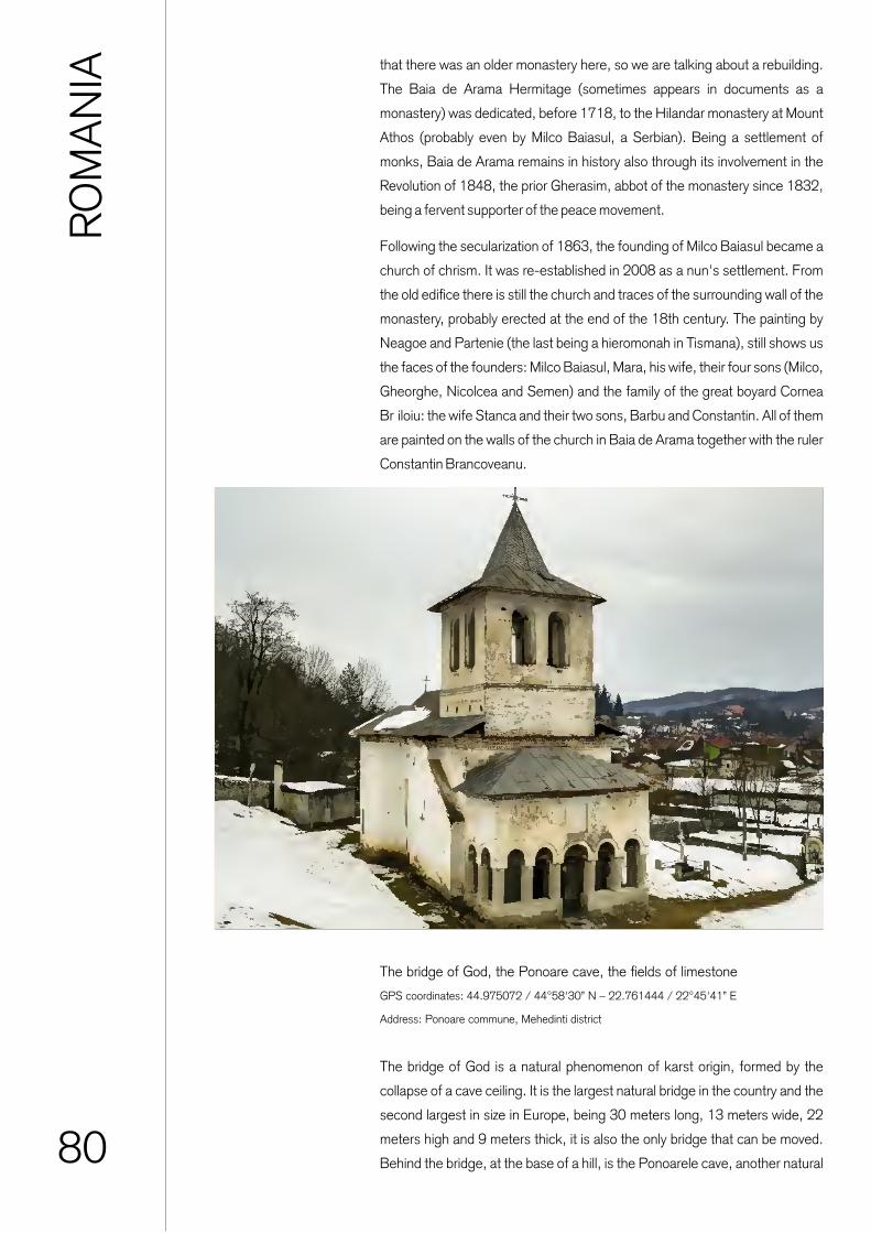
80
The bridge of God, the Ponoare cave, the fields of limestone
GPS coordinates: 44.975072 / 44°58'30” N – 22.761444 / 22°45'41” E
Address: Ponoare commune, Mehedinti district
RO
MA
NIA that there was an older monastery here, so we are talking about a rebuilding.
The Baia de Arama Hermitage (sometimes appears in documents as a
monastery) was dedicated, before 1718, to the Hilandar monastery at Mount
Athos (probably even by Milco Baiasul, a Serbian). Being a settlement of
monks, Baia de Arama remains in history also through its involvement in the
Revolution of 1848, the prior Gherasim, abbot of the monastery since 1832,
being a fervent supporter of the peace movement.
Following the secularization of 1863, the founding of Milco Baiasul became a
church of chrism. It was re-established in 2008 as a nun's settlement. From
the old edifice there is still the church and traces of the surrounding wall of the
monastery, probably erected at the end of the 18th century. The painting by
Neagoe and Partenie (the last being a hieromonah in Tismana), still shows us
the faces of the founders: Milco Baiasul, Mara, his wife, their four sons (Milco,
Gheorghe, Nicolcea and Semen) and the family of the great boyard Cornea
Br�iloiu: the wife Stanca and their two sons, Barbu and Constantin. All of them
are painted on the walls of the church in Baia de Arama together with the ruler
Constantin Brancoveanu.
The bridge of God is a natural phenomenon of karst origin, formed by the
collapse of a cave ceiling. It is the largest natural bridge in the country and the
second largest in size in Europe, being 30 meters long, 13 meters wide, 22
meters high and 9 meters thick, it is also the only bridge that can be moved.
Behind the bridge, at the base of a hill, is the Ponoarele cave, another natural

81
Hotel-restaurant Conacul Boierului, Ponoare commune
GPS coordinates: 44.974079 / 44°58'26” N – 22.763106 / 22°45'47” E
Address: Ponoare commune, Mehedinti district
B&B-restaurant Casa Alba, Baia de Arama�
GPS coordinates: 44.999520 / 44°59'58” N – 22.809396 / 22°48'33” E
Address: Victoriei Street no. 44, Baia de Arama, Mehedinti district
Hostel-restaurant Izvorul Rece, Baia de Arama�
GPS coordinates: 45.010756 / 45°0'38” N – 22.816303 / 22°48'58” E
Address: DN 67D, Victoriei Street no. 47, Baia de Arama, Mehedinti district
MONASTERY JIANA
Titular saint: "Saint Martyr Iuliu the Veteran"
Location / address: exiting Jiana commune, Mehedinti district
Access road: DJ 562A, DJ 606 asphalt very good condition
GPS coordinates: 44.413978 / 44°24'50” N – 22.739448 / 22°44'22” E
RO
MA
NIA
attraction representative of the karst relief of this area. The entrance
to the cave has the shape of a circle arch, with a width of 15 meters
and a height of over 3 meters, so that the access to the cave is easy.
The altitude of the area is 337 meters. The galleries have a total
length of 734 meters, presenting wide spaces, with rich formations
of stalagmites and stalactites.
In the plateau behind the cave you can admire another component of
the karst complex located in this area, namely the pebble fields,
which are in fact calcareous geological formations like wrinkles. The
stones have elongated and cushioned shapes, which the water
formed in the limestone rocks. These ditches sometimes exceed 4-5
meters long and have a depth of up to 30 cm, sometimes covered
with vegetation. The fields at Ponoare are notable for their variety and
extension, being known several groups of pebbles, such as those in
the Hill of the Cave, which form two distinct fields, Cleopatra's field
and Afrodita's field. All these limestone formations are natural unique
attractions at European level.
It was established as a monastery of monks in 2008. The erection of
the church began in 2012, and the construction work lasted 9
months. The monastery is built on 5 hectares of land, donated by the
heirs of an old family of boyars who had many properties in the area.

82
MONASTERY GURA MOTRULUI
Titular saint: "Saint Pious Paraskeva"
Location / address: exiting the village of Gura Motrului, Butoiesti commune, Mehedinti district
Access road: DN 6 / E70 / E79 very good asphalt, then DC 115 relatively good asphalt, the
last 500 meters without asphalt
GPS coordinates: 44.551769 / 44°33'6” N – 23.444092 / 23°26'39” E
RO
MA
NIA
Tradition attributes it to Saint Nicodemus of Tismana and the founding of this
monastery, known today as Gura Motrului. In the 18th century, the monastery
experienced a period of decline. Even after 1738, the monastery did not enjoy
too much security, as a document of November 12, 1792 shows, according
to which the Gura Motrului monastery had deposited the documents of its
estates at the Hurezi monastery. More earthquakes, fires, and also the
involvement in the Revolution of 1821 further ruined the settlement. In 1960,
following the application of Decree no. 410/1958, almost all the nuns were
expelled from the monastic community. Even so, in the period 1981-1989,
the Metropolitan Church of Oltenia executed a series of restoration works. In
1990, the sanctuary was reopened as a settlement for monks.

83
MONASTERY OF STREHAIA
Titular saint: „Holy Trinity”
Localization/address: in the center of Strehaia, Mehedinti district
Access road: DN6 / E70, very good asphalt
GPS coordinates: 44.621424 / 44°37'17” N – 23.192537 / 23°11'33” E
RO
MA
NIA
The church of Strehaia monastery, ccontrary to the general rules that require
churches to be pointed with the altar to the east, is 42 degrees toward the
south. This fact seems to be either due to a design error or was intentionally
constructed in this way. Following the restoration work carried out in 1963, it
was found that the feudal house and the church belong to special stages of
construction, the house being dated in the first half of the sixteenth century, in
the glory era of the Craiovian boyars, and the church together with the strong
walled enclosure, with the rooms and the other monastery buildings, were
from the time of the reign of Matei Basarab, more precisely around 1645. It
was also established that neither the house, the church nor the other
buildings were preceded by any other construction phase. At the beginning of
the 16th century, probably by 1510, in Strehaia was built a headquarters of
Oltenia's ruler, documented in the time of Vlad Calugarul, by a document
dated May 16, 1589. In the seventeenth century, the ruler Matei Basarab
remodeled the house (erected more than a century ago), built a church, cells,
annexes and a defensive wall in the same place. Regarding the reasons that
determined Matei Basarab to transform into a monastery the foundation
originally conceived as a typical boyar court, most historians believe that the
mountain ruler followed the example of Vasile Lupu, the ruler of Moldova who,
around 1640, turned the Citadel of Neamt iinto a monastery so that he would
not have to tear it down, as the Turks demanded. Probably, for the same
reasons, Matei Basarab also preferred to turn a boyar court into a monastery
and not tear it down. If needed, the monastery could also serve as a defense
fortress. In the second half of the seventeenth century a porch was added and
the house was also enlarged. In 1693, the abbott Silvestru built a surrounding
stone wall. Between 1716-1718, at the Strehaia monastery the Austrians (at
war with the Turks), at a distance varying between 10 and 50 m, built a
pentagonal fortification of land with a wave and a ditch, with semicircular
bastions in the corners surrounding the enclosure wall of the monastery.
An important moment in the past of the Strehaia monastery took place in the
second half of the seventeenth century, when the prince Grigore Ghica
(February 1672 - November 1673) established the third bishopric of the
Romanian Country, but for a short existence, of about six years (1673 -
1679). It had only one bishop, Daniil. All abbotts and monks from the Strehaia
monastery did not had too quiet times over time. The Turks, the Austrians,
and then the Turks again, have repeatedly broken the peace of the monastic
settlement. In 1821, on his way to Bucharest, Tudor Vladimirescu
strengthened the monastery Strehaia, as he had done also in Tismana and
Gura Motrului, giving it the role of a fortress of defense. The involvement of
the monastic settlement in the Revolution of 1821, seems to have had
adverse consequences for the monks from here, who, for fear of reprisals,
probably left the monastery.
The settlement is undergoing major repairs, being re-painted, after 118
years, both outside and inside. All rooms, houses, fountain, stables and roof
are restored. In 1846, the buildings of this settlement, the church and the
annexes were in a deplorable state. The monastic life ceased in 1864, after
the law of secularization of the monastery assets, when the old monastery

84
RO
MA
NIA from Strehaia becomes a chrism church. In 1925, the place fell to the thieves
who stole almost everything. And after the establishment of the communist
regime, the monastery suffered, in 1957, the services were forbidden.
However, renovation works have been initiated (starting in 1957). Until 1990,
the monastery was organized as a museum. Only after the communist regime
was abolished, the ancient founding of the Craiovian boyars became again a
monastic settlement. The Strehaia monastery belongs to the category of
fortified monasteries, being provided with strong defensive walls. The
enclosure consists of four sides, having a rectangular shape, towards the
middle of which is the church. The entrance to the monastery is made below a
tower that seems to still guard the silence of the people. On the right side are
the rooms and on the left side the gazebo that once served as an observation
point. The church can be considered one of the last original artistic creations
of the 17th century mountain school, having three parts: altar, nave and
pronaos, to which is added the porch, a later creation, from the time of
Constantin Brancoveanu (1693).
Regarding the painting, there are two different layers. The first, perhaps the
original, is very well cared for, and the second seems to mimic the old
iconography with differences in size and nuance. It probably dates from the
year 1826. On the left side of the nave are portraits of Matei Basarab and Mrs.
Elena, and next to the door are painted the founders Barbu Craiovescu and
"Jupan Pârvu biv Vel Vornic". Figures of benefactors of the holy place are also
painted in the pronaos.

85
DOLJ
RO
MA
NIA
Dolj district covers 7414 km2, representing 3.1% of Romania's surface
and being the 7th district in size at national level - it is part of the group of
9 district whose area exceeds 7000 km2. From an administrative point
of view, Dolj district consists of 3 municipalities, 104 communes and
378 villages. The population reported by Eurostat in 2018 in Dolj district
was 630,911 inhabitants. The territory of Dolj district extends between
43°43’ and 44º42’ north latitude and 22º50’ and 24º16’ east longitude
respectively, that is to say about one degree latitudinal and one degree
and a half longitudinal.
In Dolj district there are 700 historical monuments registered as part of
the material cultural heritage. Of these, 15 buildings belong to religious
places of national importance. The localities on whose territory these
places are found are Craiova municipality, Podari commune, Co�ofenii
din fata commune, Meline�ti commune and Malu Mare commune. The
most famous places of worship located on the territory of Dolj district
are: The ensemble of the Archdiocese of Craiova and the Metropolitan
Church of Oltenia, the wooden church "All Saints", the Church "The
Assumption of the Virgin Mary", the Jitianu Monastery. The monasteries
Cârcea, Maglavit, Popânzalesti, Cosuna can have a special importance
in relation to the religious tourism practiced locally. All these buildings
have the potential to be included in highly attractive religious routes,
which also include monasteries in the neighboring districts of Oltenia
(Mehedinti, Gorj, Vâlcea, Olt).
Regarding the built heritage with tourism potential at the level of Dolj
district, it also includes:
- the 9 museums in Craiova and Calafat - recently consolidated and
rehabilitated, they work in historical monument buildings and have a
significant heritage of unique exhibitions in the field of plastic arts,
history and archeology and ethnography, which can be included in
integrated tourist circuits, at regional, national and even international
level. To these can be added the memorial houses in the district ,
especially the one of the actor Amza Pellea from Bailesti, or the
Museum of the Cultural Association Castravita from Desa;
- medieval palaces and buildings: Vorvoreanu and Justitiei, Casa Baniei,
Glogoveanu and Valimarescu from Craiova, together with the historical
center of the city, recently rehabilitated, the culas of Almaj, Cernatesti
and Brabova;
- archaeological sites: Racari, Desa camp, the Dacian fortresses
Pelendava and Izvor, the archaeological sites of Bâzdana, Cârcea,
Cioroiu Nou and Cotofenii din Dos.
The unique immaterial cultural heritage of Dolj district is considered,
according to the district development strategy, an element of
individualization of its offer for tourists and visitors, by:
- the multitude of customs, habits, traditions and traditional crafts, as
well as the Oltenian folklore, still preserved and promoted in certain rural
areas;
- the international festivals and competitions organized in the district,
especially those of traditional music, theater and singing;
- initiatives such as the Cetate Cultural Port, which promotes the cultural
act and local traditions, or the "Constantin Brâncusi" interactive tourist
center in Craiova (under construction) where creative workshops,
exhibition spaces, conferences will be organized.

86

87

88
THE MONASTERY OF THE GREAT MARTYR DEMETRIUS
Titular saint: "Saint Demetrius","Saint Martyrs Serghie and Vah","Saint Martyr Tatiana"
and "Saint Nifon Patriarch of Constantinople"
Localization/address: Street Matei Basarab no. 1, in the center of Craiova, Dolj district
Access road: E79, Mihail Kogalniceanu street, street Sf. Demetrius, Asphalt very good condition
GPS coordinates: 44.315173 / 44°18'54” N – 23.791623 / 23°47'30” E
RO
MA
NIA
The history of Craiova is intertwined with the history of the church "Saint
Demetrius", considered the oldest religious building in the town. This is the
reason why the church has enjoyed appreciation from the godly and the pious
boyars, who have often contributed to its restoration. The archaeological
evidence brought to light after the restoration work of 1888, led some
historians to claim that this religious institution belongs to the eighth-eleventh
centuries. Other opinions place its existence in the time of the brothers Peter
and Asan (late 12th century), John of the Cumanians (first half of the
thirteenth century), or Mircea cel Batrân (1386-1418). It was founded, it
seems, by Barbu Craiovescu (at the end of the fifteenth century), probably on
the ruins of an older settlement; the first documentary attestation dates from
1645, being mentioned as "The Royal Church of Craiova". In other documents
it appears as "Baneasa". It was rebuilt from scratch in 1651, by Matei
Basarab; later, repaired by the former great gunman Petru Obedeanu in
1690, by his son, the stout Constantin Obedeanu, in 1724, when it is also
repainted, the painting being executed by Theodosius, Andrei and others.
From 1765 it becomes subordinate to the Bishop of Ramnic.
The church was badly damaged by the 1838 earthquake. It was closed in
1849 and remains in ruins until 1889. It was rebuilt with the support of King
Carol I and Queen Elizabeth, under the supervision of the French architect
Emile Lecomte de Noüy, between 1889-1893 (when it was re-consecrated).
Between 1906-1933 it was renovated and painted by the French artists
Menipot and Bories. Restoration work was carried out after this date too. The
Cathedral "Saint Demetrius" houses the relics of Saint Hieronymus Nifon,
Patriarch of Constantinople, of Saints Serghie and Vah and of Saint Tatiana. In
the opinion of N. Iorga, besides this church, the oldest school in Oltenia
(clerical) operated. In 1939, it became a metropolitan cathedral. The last
restoration and consolidation work was carried out between 2006-2007.

89
THE CHURCH "MADONA DUDU" OR "MOTHER PRECESTA"
Titular saint: "The Assumption of the Virgin Mary" and "Saint Anthony the Great"
Localization/address: Madona Dudu Street no. 13, in the center of Craiova, Dolj district
Access road: E79, Mihai Viteazu street, Ion Maiorescu street, Asphalt very good condition
GPS coordinates: 44.317094 / 44°19'1” N – 23.789929 / 23°47'23” E
RO
MA
NIA
The church bears this name because of the icon of the Blessed Virgin Mary,
found in the seventeenth century in a mulberry tree, located right where it
was built. It was built (in Brancovan style) between 1758-1760, on the site
of an old wooden church (dating from 1700), by the great clerk Constantin
Fotescu and the tanner Hagi Ion Gheorghe. Endowed by the founders with
several estates and shops, the church housed in its rooms the first mental
hospital in the region.
In 1841, it was demolished (after the earthquake of 1838 it had been
completely ruined), and between 1842 and 1844, it was rebuilt in the style
of the Austrian Baroque by a Viennese architect, brought by the boyard
Iordache Oteteli�anu. Becoming too small, the holy place was torn down in
1913, instead the present church was erected, built in neo-Byzantine style
according to the plans of architects Ion Troj�nescu (Traianescu) and Sterie
Becu (consecrated in 1942). It is one of the important religious places of
Craiova and has played an important cultural and philanthropic role over
time. Since 1992, it has been an episcopal cathedral.

90
CHURCH “HOLY TRINITY”
Titular saint: "Holy Trinity" and "Birth of the Virgin Mary"
Localization/address: Ion Maiorescu Street no. 1, in the center of Craiova, Dolj district
Access road: E79, Calea Unirii street, Popa �apc� street
Asphalt very good condition
GPS coordinates: 44.318500 / 44°19'6” N – 23.792666 / 23°47'33” E
RO
MA
NIA
The holy place is the foundation of the old housekeeper Dumitrana �tirbei
Stolniceasa, called �tirboaica, the daughter of the learned Constantin
Strâmbeanu and the widow of the Grand Chancellor Constantin �tirbei, former
governor of Craiova in 1741. The church was built between 1765-1768,
being built of stone and brick, in the Brancovan style, with the shape of the
cross, the slender tower above the nave and the porch with colonnades. In
1811, several rooms were built in the courtyard of the church, probably for
arranging a monastic settlement. It suffered during the Revolution of 1821, so
in 1823 the roof was rebuilt. At the earthquake of 1838, new damage was
registered, the church being repaired two years later by Ecaterina (Catinca)
Bibescu and her son, the great logician Barbu �tirbei, the future ruler of the
Romanian Country. In 1890, an attempt was made to build a hospital from the
church funds, but this initiative could not be realized. Instead, a medical
dispensary for the poor was built, temporarily housed in the houses of the
church yard, maintained by its income, related estates and donations.
At the end of the nineteenth century works began to restore the settlement,
which lasted until 1906. The financial side was taken care of by the sons of
Barbu �tirbei Voda, princes Alexandru and Demetrius Stirbei, the construction
being built according to the plans of the French architect and restaurateur
André Lecomte du Noüy. At the same time the entrance tower was built, the
interior painting was done, an iconostasis of oak, carved and gilded and
furniture was brought from France. In 1995, the painting was restored, and in
the first years of this century, at the request of the Town Hall, the fence and
walls surrounding the place of worship were demolished.

91
CHURCH „MÂNTULEASA”
Titular saint: "The Assumption of the Virgin Mary", "Saint Martyr Pantelimon" and "Saint
Catherine"
Localization/address: Street Calea Unirii no. 59, in the center of Craiova, Dolj district
Access road: E79 / DN 56. Simion B�rnu�iu street, Calea Unirii
Asphalt in good condition
GPS coordinates: 44.312100 / 44°18'43” N – 23.796284 / 23°47'46” E
RO
MA
NIA
Located in the center of Craiova, the Church was built from brick between
1786-1792, by the governor Barbu �tirbei and Ioan, the tailors' foreman,
instead of an older church, made by Dospina Strâmbeanu. It was radically
repaired in 1896, 1938, 1975 and 2010-2013. The first founder was
Dospina Strâmbeanu, a distant relative of the Brâncoveanu family. The first
church was made of wood, as was the custom to erect houses of worship
until the first half of the eighteenth century. The great governor Barbu
Stirbei, together with the tailors' foreman, builds a new brick and stone
foundation between 1786-1796. The holy place was burned during the
years 1800-1801, by the Turks of Pasvanoglu or of Manaf Ibrahim from
Vidin's stream (the whole town was burned down). It was again restored by
the tailors of the town, but with the help of some local boyars and
merchants.
By 1834-1835, the church was again covered with shingles, and in 1860,
other repairs were carried out. Between 1895-1896, the holy place
underwent radical changes, being enlarged to cope with the growing
number of believers. Other restoration works were carried out between
1937-1938, 1974-1976 and 2010-2013. The painting is the work of the
well-known painter Costache Petrescu (1829-1910), being executed in oil
in 1896. It is a combination of the Byzantine and the Renaissance style.

92
The Art Museum
GPS coordinates: 44.319323 / 44°19'9” N – 23.794477 / 23°47'40” E
Address: Calea Unirii no. 15, Craiova, Dolj district
RO
MA
NIA
The Art Museum of Craiova is located right in the center of the town and
has its headquarters in the splendid palace of the Mihail family, from
Calea Unirii no. 15. This imposing building was built between 1900 and
1907, following the plans of the French architect Paul Gottereau, at the
command of Constantin Mihail's family, which at that time was one of the
richest families in Romania. For the construction of the palace they used
the highest quality materials and foreign craftsmen, generally Italians
established in the Oltenia region, the architect responsible for the
supervision of the works being the Italian Constantino Cichi.
In total, the Palace has 29 rooms, plus outbuildings. This building is a
true masterpiece of architecture, managing to attract the entire
admiration of the visitors through the perfection and harmony of the
dimensions, through the delicate lines, but also firm and well contoured.
The Art Museum has been operating in this building since 1954. The
establishment of the museum was based on a donation of art objects
made to the town in 1908 by the Aman family, through a foundation. The
museum collections increased during the interwar period through a
series of acquisitions made by the town's mayoralty, as well as through
donations of Nicolae Romanescu, Barbu Druga, Jean Mihail or Nicolae
Glogoveanu, all of them part of Craiova's greatest rich and
philanthropists.
Currently the Museum has a valuable and rich cultural heritage
consisting of about 12,000 works of art. The patrimony is taken over by
the Oltenia Museum in 1950, and in 1954 all these cultural and artistic
values were to become the foundation of the current art museum, with its
own status. Thus, after being for many years the host of the most
important people of the time, or the seat of political events in Romania
and Europe, the former residence of the Mihail family became a Museum
of art, being an occasion of joy and excitement for all who have the
privilege of visiting it.
Baniei House
GPS coordinates: 44.314705 / 44°18'53” N – 23.792139 / 23°47'31” E
Address: Street Matei Basarab no. 16, Craiova City, Dolj district
An emblematic building for the entire Oltenia region is B�niei House.
Whoever visits this historical and cultural edifice has the opportunity to
step into the world of popular traditions, through the thematic exhibitions
opened here. B�niei House is the oldest civil construction in Craiova,
being erected in 1699 at the initiative of the ruler Constantin
Brâncoveanu on the site of an older building from the fifteenth century,
which had originally belonged to the large family of Craiove�ti boyars.

93
Museum of Oltenia - Department of History and Archaeology
GPS coordinates: 44.316970 / 44°19'1” N – 23.789637 / 23°47'22” E
Address: Street Madona Dudu no. 14, Craiova City, Dolj district
Nicolae Romanescu Park
GPS coordinates: 44.302102 / 44°18'7” N – 23.798774 / 23°47'55” E
Address: Bulevardul Nicolae Romanescu no. 1A, Craiova City, Dolj district
RO
MA
NIA
B�niei House is located in the central area of the city, in the immediate
vicinity of the Metropolitan Cathedral of Saint Demetrius, because here was
the administrative and commercial heart of the town at that time.
Historical reports show that the Craiova Divan was gathered here, and
during the Austrian occupation, between 1718 and 1739, the building
becomes the headquarters of the foreign administration, which fortifies it
for defense. In 1750, the building was given by the ruler Grigore Ghica to
the Bishopric of Ramnicu. Starting with 1850, the building becomes
headquarters for various institutions of the town: Craiova Court of Law, the
High School “Fratii Buzesti”, Local Seminar, State Archives.
Since 1933, the building will house the Museum of Oltenia until 1948,
when it passes under the use of the Metropolitan of Oltenia. Since 1966,
the old monument of Brancovian architecture houses the Ethnography
Section of the Oltenia Museum, having an invaluable patrimony that
currently comprises over 9,000 pieces grouped onto traditional art
collections, whether we are talking about traditional peasant tools,
traditional musical instruments, ceramic instruments, carved wood, fabrics
and carpets, leather goods, traditional costumes and clothes, painted eggs,
religious icons and objects of worship. All these wonderful things,
impossible to see and admire elsewhere, take us on a journey through the
soul of Oltenia. B�niei House, this building loaded with meanings, offers to
those present, but also to future generations, examples of spirituality of a
rich historical, cultural and social heritage.
The Museum of Oltenia comprises 3 main departments, located in different
buildings in the town of Craiova. The most important and interesting of them
is the section of history and archeology, which is located in a building that
originally belonged to the Madona Dudu Church and on which trees used to
grow. At the beginning of the 20th century, the construction of the current
headquarters began, with public funds provided by the Ministry of
Education and Cults and by the Craiova Tonwn Hall, because the first boys
and girls school was inaugurated here in 1906, for the 40th anniversary of
The reign of King Carol I. In the earthquake of 1940 the building was
severely damaged, and the communist regime abolished the school in
1948, using the building as a museum.
The Nicolae Romanescu Park in Craiova is the third largest park in Europe,
being one of the favorite places of the inhabitants of Craiova and of the
tourists who stop in the town and go to visit it, declaring themselves
fascinated by its beauty. The name of the park was given by Nicolae

94
Botanical garden
GPS coordinates: 44.323441 / 44°189'24” N – 23.790325 / 23°47'25” E
Address: Street Constantin Lecca no. 26, Craiova City, Dolj district
RO
MA
NIA Romanescu, elected mayor of Craiova in 1898, and who, out of the
desire to modernize and give a European image to the town, put into
practice a large project of landscaping of parks and public gardens.
Romanescu Park has carried many names over time, such as Bibescu
Park, Independence Park or People's Park.
To put his idea into practice, Nicolae Romanescu chose Edouard
Redont, a famous French landscape architect. The park project started
in 1900, based on the plans of this French architect, whose vision has
succeeded in creating this landscape jewelery, having been awarded the
gold medal at the 1900 Paris International Exhibition. The volume of the
planning works was a huge one compared to the technical possibilities of
that time. Over 500,000 cubic meters of earth were dug and moved, and
the length of the landscaped alleys exceeded 26 kilometers, while over
1,150,000 trees of all species were planted. The lands where no
afforestation was made were covered with grass brought from France
and Italy. The public lighting network was built by the Electric Company
of Berlin. The official inauguration of the park was held on September
29, 1903, in the presence of King Carol I of Romania. Currently, the
Nicolae Romanescu Park has an area of about 96 hectares of green
area, a central lake with an area of 4 hectares and alleys stretching over
about 35 km. Nicolae Romanescu Park also houses one of the oldest
zoos in Romania, inaugurated in 1906. Also part of the park's
composition is an Olympic sized velodrome, as well as a former
racecourse inaugurated in 1903. Thetown of Craiova has the privilege of
owning one of the largest and most beautiful parks in the entire Europe,
an exceptional monument of landscape architecture, conceived and
realized as a romantic and comforting place, impressive in size and
charming through the composition and diversity of natural elements.
The Botanical Garden of Craiova bears the name of the one who had the
initiative of its establishment in 1952, namely the university professor
Alexandru Buia, based on some 50-year-old initial plans of the French
landscape architect Emile Redont. Alexandru Buia, who was professor
of botany and later rector of the Institute of Agronomy in Craiova, turned
these plans into reality, and the current Botanical Garden was thought of
as a scientific, didactic and educational institution, being organized as an
university botanical garden. During the period of maximum development
of the garden, there were over 3,000 specimens of deciduous and
coniferous trees, as well as over 900 exotic species, all of them of great
scientific and decorative value.
Currently, the usable area is about 12.8 ha., having also 3 artificial lakes
with an area of about 0.3 ha. Inside the garden there is also a

95
Hotel-restaurant Ramada
GPS coordinates: 44.321184 / 44°19'16” N – 23.795993 / 23°47'45” E
Address: Street Calea Bucuresti no. 1, Craiova City, Dolj district
Hotel Helin Central
GPS coordinates: 44.318489 / 44°19'6” N – 23.800482 / 23°48'2” E
Address: Street Alexandru Ioan Cuza no. 14, Craiova City, Dolj district
Restaurant Iberico
GPS coordinates: 44.317182 / 44°19'21” N – 23.798969 / 23°47'56” E
Address: Street Romain Rolland no. 13, Old center, pedestrian area, Craiova City, Dolj district
MONASTERY OF SADOVA
Titular saint: "Saint Nicholas" and "The entrance of the Virgin Mary into the Church"
Localization/address: Street Drumul Manastirii, Sadova Commune, Dolj district
Access road: DN 55, then DJ 551, very good asphalt
GPS coordinates: 43.905169 / 43°54'18” N – 23.925509 / 23°55'32” E
RO
MA
NIA
greenhouse with a total area of 750 sqm, where we find a collection of over
100 species of cacti, in a wide variety of forms. We can also admire plants
and trees from all corners of the world, some can be easily recognized,
while others are completely unknown in our country. The Botanical Garden
also has a Herbarium, which at present contains about 50,000 sheets of
great scientific value, which are permanently available to teachers,
researchers and students, but also to all those interested and passionate
about botany. The "Alexandru Buia" Botanical Garden is known both
nationally and internationally, being included since 1974 in the International
Association of Botanical Gardens. The Botanical Garden has recently
become again a place of promenade and relaxation for the people of
Craiova, after the renovation of the spring of 2016, generously offering the
inhabitants of Craiova a well-deserved recreation refuge in the middle of
nature.
It is documented on August 20, 1530, in a letter from Vlad the drowned.
The monastery church was founded (probably in wood) at the beginning of
the 16th century by the Craiove�ti boyars (the patron Barbu). It was for a
long time one of the most important places of worship in the Romanian
Country. In 1640, Matei Basarab rebuilds the settlement, and by a decree
of November 27, 1640, the ruler forbade the dedication of the sanctuary to
the Holy Places.
The monastery was fortified like its other foundations; Paul of Aleppo
observed in August 1657, when he visited the monastery with the patriarch

96
Hotel-restaurant Tata si Fii, town of Bechet
GPS coordinates: 43.786058 / 43°47'10” N – 23.954573 / 23°57'16” E
Address: Street Alexandru Ioan Cuza nr. 51, Bechet City, Dolj district
Hotel-restaurant Casa Verde, town of Bechet
GPS coordinates: 43.779065 / 43°46'45” N – 23.961584 / 23°57'42” E
Address: Street Calea Dunarii nr. 7, Bechet City, Dolj district
RO
MA
NIA Macarie of Antioch, that it resembles that of Strehaia, and the church, that of
Bucov��. The next founder in Sadova will be Preda Brâncoveanu, who will
continue the started work by building the cells and the bell tower on the south
side, and Constantin Brâncoveanu will be the founder of the infirmary church,
in 1693. Being an important monastic and cultural center in the south of
Oltenia, worthy worshipers have been active here, taking care of both the
administrative and the cultural side. In the 19th century, the Sadova
monastery was affected by frequent Turkish incursions, but also by bad
weather and earthquakes.
Although some abbotts (Dionisie Romano) tried to restore its former brilliance,
for this formerly important monastic center difficult times followed: the
monastery would be abolished (during the secularization period) or
abandoned. This period has influenced the appearance of the settlement. It
was re-established as a monastic settlement in 1992. The church no longer
retains its original appearance, being affected by the long period in which it
was left abandoned. The current appearance is due to last interventions of
consolidation and restoration in 1996.

97
CHURCH "SAINT NICHOLAS" IN CALAFAT
Titular saint: "Saint Nicholas"
Localization/address: Street Traian nr. 25, Calafat City, Dolj district
Access road: E79 / DN 56, then DN 56D, Traian Street, in the center of Calafat, Dolj district
Asphalt very good condition
GPS coordinates: 43.995593 / 43°59'44” N – 22.931678 / 22°55'54” E
RO
MA
NIA
The church was built between 1730-1740, in the form of an underground
hut, popularly called "Slum on the hill”. The place of worship was originally
intended for sailors who came to pray to Saint Hierarch Nicholas. By 1830,
the new church was consecrated in the presence of the Lord of the
Romanian Country, Alexandru Ghica, and of the Serbian prince, Milos
Obrenovici. According to other sources, the place of worship was erected
between 1853-1856. In 1861, the church underwent extension work. It
was visited several times by King Carol I, especially during the war of 1877,
after which it became known as the Cathedral of Independence.
Demolished at the turn of the nineteenth and twentieth centuries, the
church was rebuilt in brick, in its current form, between 1899 and 1906
(sanctified in 1910).
It was completely repaired during 1933. It was affected by the bombings of
World War II and the earthquake of March 4, 1977. The painting was
executed in 1909-1910, in mixed technique. ÎIn 1991, the restoration of
the painting was completed, and in 2001 took place the re-
consecrationofthe settlement. Other renovation work was carried out
between 2002-2005 and 2009-2011.

98
Museum of Art and Ethnography (Marincu Palace)
GPS coordinates: 43.994571 / 43°59'40” N – 22.932424 / 22°55'57” E
Address: Street 22 Decembrie nr. 6, Calafat City, Dolj district
Monument of the War of Independence
GPS coordinates: 43.997231 / 43°59'50” N – 22.934442 / 22°56'4” E
Address: Street Baba Lupa nr. 1, Calafat City, Dolj district
Hotel-restaurant Coliseum, town of Calafat
GPS coordinates: 43.993466 / 43°59'36” N – 22.931091 / 22°55'52” E
Address: Street Gheorghe Doja, Calafat, Dolj district
RO
MA
NIA
The Museum of Art and Ethnography in Calafat is a remarkable building
located right in the center of the town, also known as the Marincu Palace. It
was built according to the plans of the French architect Paul Gottereau,
famous at the beginning of the 20th century in Romania. The builders were
Italian craftsmen, led by the engineer Pietro Adotti. The foundation stone was
laid in the fall of 1904, the construction being completed three years later and
being inaugurated in 1908. The architecture was made in the neo-classical
style of the French Baroque, with influences of the Romanian architecture
from the beginning of the 20th century. The building occupies an area of
8,330 square meters, having inside almost 50 rooms structured on three
levels. The total cost amounted then to the huge sum of one million gold coins.
In 1926, the palace became property of Calafat Town Hall and functioned as
St. Mary's Girls' School, and later served as a kindergarten. Later the palace
hosted the courses of the Agricultural School of Calafat and was host for
various administrative services. Since 1967, the Museum of Art and
Ethnography operates in this building. Currently, the museum has a rich
collection of art objects exhibited in permanent exhibitions, but also organizes
personal exhibitions of contemporary artists from the country and abroad. In
September 2012, a section of Calafat history was inaugurated here, realized
with the support of the descendants of the Marincu family and who made
important donations to the museum. The Marincu Palace is an impressive
legacy that the noble Marincu family, so severly tested by fate, generously left
to the community in which it lived. Due to the cultural and social events it
hosts, this edifice can be considered one of the most important cultural
centers for the entire Danube region.
The town of Calafat is marked in the history of Romania as the place where the
Independence War of 1877 against the Ottoman Empire began. From this
town, on April 26, 1877, from a place on the Danube, the first cannon was
fired towards the positions occupied by the Turkish army on the Bulgarian
shore.
A few years after the end of the war, there was erected a monument
reminiscent of this glorious episode in the birth of the modern Romanian state.
In 1977, on the anniversary of 100 years, the authorities moved the original
monument to another place and in this place was erected the Memorial of
Independence, the work of the sculptor Pavel Bucur. It is made of travertine, in
a bas-relief style, having representative battle scenes on the facade.

99
MAGLAVIT MONASTERY
Titular saint: "The Healing spring" and "The Birth of the Virgin Mary"
Localization/address: Drumul Monastery Street, Maglavit commune, Dolj district
Access road: E79 / DN56, then DN 56A, then DJ 554, asphalt very good condition
GPS coordinates: 44.032950 / 44°1'58” N – 23.065737 / 23°3'57” E
RO
MA
NIA
The first church was erected in 1935, by several locals, on the place
where the shepherd Petrache Lupu had seen on May 31, 1935 "a white
bearded monk [...] who stood two hands above the ground". In 1935, on
several Fridays, Petrache Lupu had seen the Old man (God),
transmitting commands to the world for heading towards the Church, to
the right faith. Soon, a few thousand believers begin to arrive in Maglavit
every day.
On the places where the revelations took place are raised crosses,
wayside crosses and even a pulpit for preaching the divine
commandments. On September 14, 1935, the foundation stone of the
future monastery was laid, and some monks were sent here. It is
noteworthy that on the Danube a small village of nuns was established.
The construction of this site has seen agitated times for 70 years. In
1936, the construction of several houses began, at a rather slow rate.
The Second World War and the establishment of the communist regime
led to the abolition of the monastery. The monastic life began only in
1990, when the construction of the settlement was resumed. The works
evolved slowly, being intensified only after 2006. In 2010, the Maglavit
Monastery was transformed from a monk monastery to a nun's
monastery. Currently, the construction work is almost completed.

100
RO
MA
NIA

101
RO
MA
NIA

102
OLT
RO
MA
NIA
Olt district is located in the South-West Oltenia region, on the lower course of
the river that gave it its name and is part of the category of districts that lie on
the Danube river.
The total area of 5,498 km2, representing 2.3% of the territory of the country,
places Olt district on the 22nd place at the level of Romania as a surface. In
terms of population, according to Eurostat, in 2018 there were 400,802
inhabitants in Olt district.
From the administrative point of view, Olt district comprises 8 towns, of which
2 municipalities, and 112 communes.
It is contiguous with Vâlcea district to the North, Arge� and Teleorman districts
to the East, Dolj district to the West and the Danube River to the South for a
distance of 45 km, separating it from Bulgaria.
Olt district has a rich religious cultural heritage, 758 historical monuments are
registered on its territory. Of these, 17 buildings belong to religious places of
national importance. The localities on whose territory these places are found
are Slatina municipality, Brâncoveni commune, Calui commune and Poboru
commune. Generally, religious places of worship receive a large number of
visitors during various Christian holidays, church and monastery celebrations.
The most famous places of worship located on the territory of Olt district are:
Calui Monastery, Brâncoveni Monastery and Clocociov Monastery.
Also, the territory of Olt district contains a true treasure trove of history. The
archaeological discoveries made on Oltetului, Oltului and Dârjovului valleys
highlight the first forms of human life on the territory of today's Romania. The
most important archaeological finds in Olt district are:
· The Pentingerian tabula (map of the Roman world drawn up between 260-
271 AD) which kept the names of daves (centers) such as Acidava (located in
Eno�e�ti village, center of the Geto-Dacians) and Sucidava (located in
Corabia-Celei, center of the Suci);
· The ruins of the Roman Fortress and the secret fountain in Sucidava (in
Celei, near Corabia), built by Emperor Aurelian in 271-275;
· The ruins of the largest Roman city in South Dacia Romula - Malva, in Resca
(Dobrosloveni commune) at 8 km from Caracal.
· Neolithic vestiges from Vadastra, Farcasele, Brebeni, Slatina, Oboga, Orlea.
Other monuments of significant historical, architectural and cultural
importance located on the territory of Olt district are: "Nicolae Titulescu"
Memorial House, Iancu Jianu Memorial House, Bratasanu Mansion, Neamtu
Mansion, Calateanu Manor, Galita Manor (Câmpu Mare-Dobroteasa),
Monument of Ecaterina Teodoroiu, Museum of Archeology and Ethnography
in Corabia, Romanatiului Museum in Caracal, Romula archaelogical site
(Resca), Caracal National Theater.

103
RO
MA
NIA
From the perspective of the intangible cultural heritage, on the territory of
Olt district there are numerous settlements in which traditions and
handicrafts practiced from the earliest times are preserved, of which we
mention in particular the pottery, practiced since Neolithic. Today in Olt
there are three pottery centers left (Oboga, Romana, Corbeni) that produce
glazed and unglazed ceramics in different shapes and decorations. Other
well-preserved traditional crafts in Olt district are: Vadastra furrier, wool
spinning, sewing - Priseaca, Curtisoara, Icoana, Cezieni, wood and bone
carving - Boian Plain, traditional wood and glass painting - Corbu, masks
and ironwork - Osica - Brîncoveni.
Local traditions are celebrated during different holidays such as: Romanian
"Calus" - the folklore festival of Pentecost, "Feast of the bread" - an ethno-
folkloric event that marks the end of the harvest, "Feast of the Ie” -
celebration of the national costume in the Romanati area.
The ethnographic heritage mirrors the popular creation of almost all the
villages and communes of Olt district, territory in which three ethnographic
areas meet: Olt, Romanati and Câmpia Boianului. The traditional costumes
of Olt, through the variety of its pieces, the techniques and materials used,
the organization of decorations on the surface of the pieces and the
decorative motifs used, is one of the most complex fields of folk art.
From the point of view of the natural heritage, Olt district is noted for its
forests and floristic reserves such as: Branistea Catârilor forest,
Calugareasc� forest and Potelu forest for different species of oak, Seaca
Opt��ani forest and bush tree reserve, as well as the Academy's peony
reserve that aims to protect the species of Romanian peony. The Danube
River, which runs through the south of the district, is an important natural
resource that can contribute to capitalizing the district's tourism potential. In
the territory of Olt district are identified 12 protected natural areas of
national interest, 16 Nature 2000 sites and 3 special avifaunistic protection
areas.
Even though at present the tourist interest is relatively low, Olt district has
significant cultural tourism objectives from the point of view of the added
value that they bring to the national cultural heritage.

104
MONASTERY OF MAINESTI
Titular saint: "The covering of the Virgin Mary"
Localization/address: Sat Mainesti street, on the outskirts of Bals, Olt district
Access road: E574 / DN65, then DJ643, relatively good asphalt
GPS coordinates: 44.330592 / 44°19'50” N – 24.105373 / 24°6'19” E
RO
MA
NIA
The first church was built of wood by the late Matei Bârzeanu, in the years
1742-1743. In 1745, the holy place was consecrated by the founder of the
Bishopric of Ramnicu. In 1805, Popa Nicolae the seneschal, Ioanichie Preda
and the senechal Nicolae M�inescu began the construction of a brick and
stone church, completed on September 29, 1809. Painted in 1810-1812,
the church initially received the dedication "Saint Hierarch Nicholas". Here,
some of Iancu Jianu's outlaws became monks after he no longer was an
outlaw, in 1818. For this reason, in the local folklore, the hermitage remained
known as the "Outlaws' Hermitage".
After the secularization of the monastery assets, it became a church of
chrism, and in 1926, it was closed. After some repairs made between 1930
and 1940, the church was reopened in 1941. In 1979, thorough renovation
work was carried out. It is worth noting that in the portraits of the founders one
can observe the period costumes with specific elements of the Romanian
traditional clothes. In 1996, the monastic settlement was reopened as a
monastery for nuns.

105
CALUI MONASTERY
Titular saint: "Saint Hierarch Nicholas"
Localization/address: Street Fratii Buzesti, Calui commune, Olt district
Access road: DJ643, then DC 9, very good asphalt
GPS coordinates: 44.462594 / 44°27'45” N – 24.031825 / 24°1'54” E
RO
MA
NIA
Named in ancient times Cepturoaia, the settlement was erected in 1515, during the
reign of Neagoe Basarab (1512-1521), the first founders being Vlad Banul
(grandfather of the three Buzesti brothers), Demetrius Pârcalabul and Balica the
Commander. The works were only completed in 1588, through the efforts of the
Buzesti brothers (Radu, Preda and Stroe). In 1594, were completed the rooms and
the bell tower, in 1600, the church was painted (by Mihnea zugravul) and in 1610, a
porch was added (ruined in 1859). The Caluiu monastery has been used throughout
the centuries as a necropolis of the Buzesti family: Preda Buzescu, big ruler of
Craiova, buried in December 1608, Stanca - Radu Buzescu's wife, buried in
February 1590, and Radu Buzescu - Chief Administrator, buried in January 1610.
Dedicated to the Holy Sepulcher in Jerusalem, the monastery suffered because of
the carelessness of the Greek monks. In 1821, it was set on fire by the Turks and in
1823, Romanian monks were brought in. During the time of abbott Chiriac
Râmniceanu (1823-1828) several works were carried out to consolidate the holy
place. In 1834, the church was repainted by the boyard Barbu Cosoveanu the
painter. In 1856, it returned to ruin, so that in 1859-1861, other consolidation works
were carried out. After the secularization of the monastery assets, the state of the
monastery worsened again. Between 1986 and 2006, extensive restoration and
modernization work was carried out, several buildings and an imposing traditional
church with three towers and an open porch being erected. The building founded by
the Buzesti was initially a monastery of monks, then of nuns until 1985-1986, when
it became a monastery of monks again.

106
MONASTERY CLOCOCIOV
Titular saint: "Saint Archangels Michael and Gabriel" and "The Birth of the Virgin Mary"
Localization/address: Street Manastirea Clocociov no. 3, Slatina, Olt district
Access road: E574 / DN65, then George Poboran Street, then Vintila Voda Street, then
Basarabilor Street (DC 90A), then Manastirea Clocociov Street Asphalt good condition
GPS coordinates: 44.411623 / 44°24'42” N – 24.363547 / 24°21'48” E
RO
MA
NIA
It was attested from the time of Neagoe Basarab (1512-1521), when it was
mentioned in an exchange of estates between its abbott and the boyard
Manea of Persani, the founder of the Seaca-Musete�ti monastery. In 1625,
Alexandru Coconu dedicated the monastic settlement to the Cutlumu�
monastery in Mount Athos. The earthquake of 1628 and more fires ruined the
old monastic center. For this reason, in 1645, during the reign of Matei
Basarab, the monastery is rebuilt by Diicu Buicescu, great commander.
Ruined again because of the vicissitudes of time, in 1980, extensive
restoration work begins, works that have gradually restored the monument to
its present state.
Through its architecture, the Clocociov monastery, with all the successive
degradations, due to the restoration that sought to respect and preserve the
features of the old settlement, is part of the monuments from the middle of the
XVII century, still dominated by the stylistic characteristics of the time of Matei
Basarab; the variety of forms is tempered by the simplicity of the construction,
in which decoration is used with measure.

107
MONASTERY OF STREHARETI (STRIHARETI)
Titular saint: „Assumption of the Virgin Mary”
Localization/address: Strehareti Street no. 154, Slatina, Olt district
Access road: E574 / DN65, then Carol I street, then Streh�re�i street, good condition asphalt
GPS coordinates: 44.443755 / 44°26'37” N – 24.351696 / 24°21'6” E
RO
MA
NIA
It is first attested in 1478, being mentioned in several documents from
1578, 1608 and 1620. Some sources consider the bishop Varlaam of
Râmnicului, metropolitan of the Romanian Country (1672-1679), to be its
founder. Most likely, the holy place was founded by the monk Serafim, who,
during the reign of Matei Basarab, became bishop in Buzau. On April 24,
1664, Serafim bought the Strehare� estate in order to build a monastery
here, and was helped by the ruler Radu Voda Leon (1664-1669), who in
1665, donated part of his estate to the future monastery.
The new settlement was completed before 1668, when it was dedicated to
the Metropolitan of Bucharest. In a 1671 document, the founder's intention
to paint the church is mentioned. Ruined for various reasons, the monastery
was restored in 1844, by the ecclesiastical Joseph, who also built some
new outbuildings. After the secularization of the monastery assets, the
buildings were transformed into a hospital. Consolidation works were
carried out by the Historical Monuments Commission in the period 1930-
1936, and by the Directorate of Historical Monuments, in 1982.

108
Olt District Museum
GPS coordinates: 44.430361 / 44°25'49” N – 24.359963 / 24°21'36” E
Address: Street Ana Ipatescu nr. 1, Slatina City, Olt district
Museum of Romanati
GPS coordinates: 44.109371 / 44°6'33” N – 24.348064 / 24°20'53” E
Address: Street Iancu Jianu nr. 17, Caracal, Olt district
RO
MA
NIA
The Olt District Museum came into being in 1952, but the idea of such an
establishment had already appeared since the first years after the end of the
First World War, in the form of donations of old documents, books and prints,
historical objects or works of art, with a view to establishing a museum of the
Olt. Housed in a wonderful historical building in the center of Slatina, the
museum enjoys an exceptional interior organization, with generous and
excellently arranged spaces that house collections and exhibits of great
historical and artistic value.
The history and culture section of Slatina is arranged in 5 rooms, being
inaugurated on April 23, 2003. Includes countless landmarks of the history of
Slatina, historical testimonies of the evolution of this locality: old documents,
coins, books, objects of worship, plans, sketches and old photographs,
together with the reconstruction of period decorations, such as a reception
hall and a few shops from the town. Other departments of great interest to the
visitors of this museum are those of plastic art, the section of folk art and
ethnography and the history-archeology section.
The Caracal Museum bears the old name of the region, namely the Romanati.
The idea of setting up a museum in the locality appeared at the beginning of
the 20th century, when Ion Hagiescu Miriste, a great magistrate of the time,
originally from Caracal, bought a building in 1900, with the purpose of
arranging a space for exhibiting here paintings and sculptures. At his death in
1922, this great man of culture and art lover left by his will the wealth of the
district of Romanati, in order to promote and support the fine arts by setting
up a museum. Unfortunately, his wish could not be realized due to the lack of
interest of the local authorities, and his heirs sold the vast majority of the
artworks collected by the deceased. It was only in 1949, on September 26,
that the Museum of the Romanati was truly established, arranged in a building
in the center of the town, and initially had 2 sections, one of history and one of
arts. In 1950 the museum was moved to another, much more generous
building, with 23 rooms.
Today the museum has 4 main sections: the archeology-history section, the
Iancu Jianu memorial section, the arts section and the ethnography section.
Its collections are impressive, for example the history section contains over

109
Caracal National Theater
GPS coordinates: 44.113239 / 44°18'56” N – 24.309577 / 24°20'22” E
Address: Pia�a Victoriei no. 10, Caracal City, Olt district
Sucidava fortress
GPS coordinates: 43.765217 / 43°45'55” N – 24.459036 / 24°27'32” E
Address: sat Celeiu, Corabia City, Olt district
RO
MA
NIA
20,000 pieces of invaluable value, some with an age of over 6,000 years,
as well as many objects of Roman origin, originating from the settlement
with the name Romula, near today's town of Caracal. Roman statues and
sarcophagi are grouped in a lapidarium, which comprises over 20 pieces.
The art section comprises a collection of over 500 paintings and other
works of art, and the collection of Roman gemstones and semiprecious
stones is the fifth largest in the world.
The building of the National Theater in Caracal is surely one of the most
representative and beautiful works of architecture, more than a century old.
Construction work began on July 14, 1896, following the plans of Austrian
architect Franz Bileck, the construction was completed in 1901. In that
year, Caracal had about 12,000 inhabitants and an exceptional cultural life.
Between 1959 and 1960 major renovation work was carried out. The
devastating fire of 1987 put an end to theatrical performances here, to
everyone's regret. The reconstruction works took many years, but finally on
December 19, 2008 this building could be reopened to the general public,
now having the brilliance and elegance of former times. All the architecture
and decoration details were meticulously made, the painting completely
remade, and the performance hall was equipped with modern sound and
lighting equipment.
Sucidava fortress is located on the Danube, a few km from the outskirts of
Corabia. This fortress-type settlement was founded by Roman troops
between the years 257-275 d.Hr., being a Roman defense fortress with 8-
10 towers, which included an urban settlement, a paleo-christian basilica,
Roman baths and cobbled streets. In the fortress there is also a secret
fountain, a remarkable architectural achievement. The Romans built this
fortification on the site of an older metropolis, identified as the capital of the
Dacian tribe of the Suci. Near this fortress was erected the bridge of
Constantin the Great, with a length of about 2,400 meters, which from 328
allowed the crossing of the Danube, linking Sucidava with the settlement of

110
The Boian Plain Museum and the Neolithic village
GPS coordinates: 44.155135 / 44°9'18” N – 24.539289 / 24°32'21” E
Address: Street Nicolae Titulescu no. 33, entering Draganesti Olt, Olt district
RO
MA
NIA Oescus. One one foot is left of this bridge.
The town was remade and enlarged several times under Byzantine rule, in the
time of Theodosius II, then Justinian the Great, but was also destroyed and
plundered by the invasions of the Huns. It seems that it was completely
abandoned by the Byzantines around 600. The fortress, however, survives the
times, so it appears in historical accounts from the time of Michael the Brave
as a garrison of defense on the Danube against the Ottoman armies.
Many pieces of brick still bear the sign of the fish, an early Christian symbol.
The most interesting historical element is the Secret Fountain, which was built
in the sixth century, but was discovered only in 1958, so that many historical
vestiges of invaluable value have been found inside. Obviously her role was to
ensure the water supply of the fortress during long sieges.
An unusual fact is the discovery related to the heating of the houses, which
was made through a sophisticated system of tubes under the floor, an
innovative solution at that time. The fortress is built of burnt brick and massive
stone blocks, managing to withstand the nearly 2,000 years of shaken
history. At the entrance to the fortress there is a small museum where visitors
can admire some of the objects discovered here, bronze ornaments, lead
rings, seals, ceramic fragments, even cult objects in the form of a cross,
because the church here is considered as the first Christian church discovered
in the space between the Danube and the Carpathians. The church was
shaped like a nave, with the altar facing east. Near the altar were found
skeletons buried in Christian rite, with the head at sunset, the feet at sunrise
and the hands near the body. Also inside the church were found various
Christian artifacts, oil lamps with cruciform wreath, bronze crosses, ceramic
scraps with Christian inscriptions.
At the initiative of Professor Traian Zorzoliu, who dedicated practically his
whole life to this objective, the Museum of the Boian Plain, a unique place in
Romania and even in Europe, was created. It is practically an open air museum
that tells about the popular traditions of this area, since 6,000 years ago. In
the courtyard of the museum there is a small cross, a small church, a
traditional peasant house, an authentic hut, as well as 6 clay huts of a
reconstructed village, from the Neolithic era, given that in the area have been

111
Hotel-restaurant City, town of Slatina
GPS coordinates: 44.425570 / 44°25'32” N – 24.376737 / 24°22'36” E
Address: Street Ecaterina Teodoroiu no.1, Slatina, Olt district
Restaurant Trattoria del Gusto, town of Slatina
GPS coordinates: 44.430194 / 44°25'48” N – 24.364021 / 24°21'50” E
Address: Street Independentei Bl. T1 parter, Slatina, Olt district
Hotel-restaurant Retro, Caracal
GPS coordinates: 44.116364 / 44°6'51” N – 24.345893 / 24°20'45” E
Address: Street Radu Serban no.2, Caracal, Olt district
Restaurant Coquette Bistro, Caracal
GPS coordinates: 44.111822 / 44°6'42” N – 24.343861 / 24°20'38” E
Address: Pia�a Victoriei nr. 14, Caracal, Olt district
RO
MA
NIA
discovered traces of a prehistoric culture dating from the V-VI millennium
before our era. The collections of objects include over 6,000 exhibits, tools,
ceramics, fabrics, iron works.
The hut in the courtyard is a typical dwelling for this plain area. Inside there
were usually 2 rooms, one used for cooking and dining, and the other for
living and sleeping. Mandatory was also present the dowry box, filled with
sheets and fabrics that were a family heritage. The ones now on the walls
are from the 18th century. The huts in the Neolithic village reconstruct the
life of 5-6,000 years ago. The Neolithic village is made up of six open-air
huts, on a field surrounded by a moat and a fence of woven wickets.
Entrance is made on a wooden deck, and the huts are natural in size. A hut
represents a fisherman's house, another a farmer's house, another a
potter's house. The houses were built of reed and poles inserted into the
ground, and among the reeds soil was laid. Between them stood a
lacustrian dwelling, where provisions were kept, for the settlements were
erected in valleys that were often flooded. The huts were built close
together, the village streets were no larger than two meters, sometimes the
huts were attached to each other. The buildings were low, because the
height of the people did not exceed then 1.50-1.60 m. The houses did not
have ceilings, but they were lined inside. Each hut had a fireplace, an oven,
and the bed was built of raised earth, on which were placed skins or mats.
All have neolithic objects or reconstructions of some Neolithic objects,
tables, worship altars, tools for the household. The inauguration of this
prehistoric village was made in 2010. The museum is visited annually by
many tourists, the most interested being those who came from abroad and
who thus have the unique opportunity to admire these traditional Romanian
exhibits on the spot.

112
Hotel-restaurant Sucidava, Corabia
GPS coordinates: 43.771609 / 43°46'18” N – 24.513429 / 24°30'48” E
Address: Street Portului, Corabia, Olt district
BRÂNCOVENI MONASTERY
Titular saint: "The Assumption of the Virgin Mary", "Saint Archangels Michael and
Gavriil", "Healing spirng" and "Sant Martyrs Brancoveni"
Localization/address: Prim�verii street, exiting Brâncoveni commune, Olt district
Access road: E64, very good asphalt
GPS coordinates: 44.305071 / 44°18'18” N – 24.306548 / 24°18'23” E
RO
MA
NIA
At the beginning of the 16th century the Brâncoveni boyards built the
architectural ensemble that will bear their name, as a place of refuge; in its
precinct, in 1570, the Celea mistress will raise a wooden church, and some
monks will be brought. The first documentary attestation dates from 1582-
1583, when Mihnea Turcitul strengthens some of the older donations. In
1634, Matei Basarab begins the restoration and transformation of the
architectural ensemble provided with an ingenious system of fortifications.
From the time of Matei Basarab remain the bell tower, the spacious vaulted
cellars and the defense wall provided with battlements. The present church
was built in place of the old one by Constantin Brancoveanu, in 1700. He also
founded the infirmary church (in the triconc plan), in 1702.
The large church, built between 1699-1700, in Brancovan style, is in the form
of a cross, with the open porch, supported by eight stone columns, arranged
in the center; the golden iconostasis is the original one; it has a tower on the
nave, and the doors are made of solid carved oak. The church houses several
graves, including the one of Papa Brancoveanu (father of Constantin
Brancoveanu). The painting dates from 1837, the authors being unknown.
The ensemble suffered during the Turkish-Austrian war of 1716-1718, and at
the earthquake of 1838. After the secularization of the monastery assets,
there remained a modest settlement, whose curator was Popa �apc�. In time,
the monastery was ruined, partially restored by Bishop Vartolomeu Stanescu
(1921-1938).
Between 1940-1959, it was a nun's monastery, but following the decree
410/1959, the holy place was abolished, here functioning, for a short time,
an asylum for the elderly; then it remained deserted for 20 years. After 1980,
several nuns were brought from the Clocociov monastery and the first repairs
began. Major renovation works were carried out.

113
STUDINA MONASTERY
Titular saint: "The Ascension of the Holy Cross" and "The Birth of Saint John the Baptist"
Localization/address: Manastirii Street, on the outskirts of Studina commune, Studini�a
village, Olt district
Access road: DN54, then DC 139A, good condition asphalt
GPS coordinates: 43.974540 / 43°58'28” N – 24.418506 / 24°25'6” E
RO
MA
NIA
It is a relatively new monastery, the first works began in 1994, by building a
trinity. The erection of this monastery was the wish of Mrs. Maria Crîmu
from Traian locality, Olt district. Other enlargement and consolidation works
have been carried out in the last two decades, and in 2009, the monastery
chapel was consecrated.

www.cdst.ro
RELIGIOUS TOURISMIN THE CROSS-BORDER REGIONROMANIA-BULGARIA