Relief in a vulnerable envirionment final
76
Darfur: Relief in a vulnerable environment
-
Upload
brendan-bromwich -
Category
Documents
-
view
14 -
download
4
Transcript of Relief in a vulnerable envirionment final

Darfur: Relief in a vulnerable environment


D A R F U R : R E L I E F I N A V U L N E R A B L E E N V I R O N M E N T
1© T E A R F U N D 2 0 0 7
Darfur: Relief in a
vulnerable environment
Contents
Acronyms 4
Team biographical data 5
Executive summary 7
1 Introduction 13
2 Darfur and environment 15
2.1 A particularly vulnerable environment 15
2.2 Population growth and the background to conflict 19
2.3 The current conflict 21
2.4 Displacement and relief 23
2.5 Recovery 27
2.6 Longer term 28
3 Appropriate environmental mitigation: sustainable resource management 29
4 Integrating environment in relief 32
4.1 Rationale 32
4.2 Recommendations 33
5 Forestry 35
5.1 Rationale 35
5.2 Recommendations 35
6 Water resource management 39
6.1 Rationale 39
6.2 Recommendations 40
2 © T E A R F U N D 2 0 0 7
D A R F U R : R E L I E F I N A V U L N E R A B L E E N V I R O N M E N T
7 Broader relief practice 42
7.1 Integrating relief, recovery, development and adaptation to climate change 42
7.2 Environment as a cross-cutting theme in relief 43
7.3 Engineering and technical capacity in relief 43
7.4 Resource management, mandates and UN humanitarian coordination 44
7.5 Climate change research and dialogue 45
8 Darfur Environment Study – the way forward 47
8.1 Further assessment 47
8.2 The environment tracking template 47
Appendix A Integrating environment in relief 49
A1 UNHCR environmental management principles 49
A2 Integrating environment at project and community level 49
Appendix B Forestry 53
B1 A summary of the ICRAF Study relating to changes in land use in Sudan 53
B2 Strategic planning for forestry 54
B3 Community forestry models 55
B4 Compensation forestry 57
Appendix C Water 58
C1 The hydrogeology of Darfur 58
C2 Practical guidance on groundwater monitoring 59
C3 Dams, hafirs and rainwater harvesting 61
C4 HIU hydrogeology map 62
Appendix D Review of three reports on Darfur environment 65
D1 UNEP PCEA – draft report on Darfur 65
D2 Rapid Environmental Assessment at the Kalma Otash and Bajoum camps 66
D3 Environmental degradation as a cause of conflict in Darfur 67
Appendix E Climate change 68
E1 Impacts of climate change 68
E2 Vulnerability to climate change 69
E3 Adaptation 69
E4 The humanitarian context 70

D A R F U R : R E L I E F I N A V U L N E R A B L E E N V I R O N M E N T
3© T E A R F U N D 2 0 0 7
Tables
Table 1 Population densities in Darfur prior to the conflict 20
Table 2 Examples of concentration of population during the crisis 24
Table 3 Change in land use/cover for a sample of 10 sites across Sudan 53
with rainfall less than 900mm (only land uses above 6% shown)
Table 4 Change in land use/cover for a sample of 8 sites across Sudan at 54
altitude between 500 and 1,500m (only land uses above 6% shown)
Table 5 UNEP assessment of environmental issues in Darfur 65
Figures
Figure 1 Woodfuel supply and demand balance in Sudan 16
Figure 2 El Fasher annual rainfall 1917–2005 17
Figure 3 Variability of annual maximum vegetation index (NDVI) 18
Figure 4 Agroforestry destroyed in Garaash 22
Figure 5 A charcoal store in Abu Shouk camp in North Darfur 25
Figure 6 A destroyed village in the Masterei area of West Darfur in 2003 28
Figure 7 Divergence in climate change modelling in the Eastern Sahel 45
Figure 8 Community environmental assessment and management in relief 50
Figure 9 Groundwater potential in Darfur 62
Figure 10 Change in length of growing period 2000–2020 68
Cover photo The cover photo shows deforestation and brick-making at Khasab camp in Kutum

4 © T E A R F U N D 2 0 0 7
D A R F U R : R E L I E F I N A V U L N E R A B L E E N V I R O N M E N T
Acronyms
BC Basement complex
CBO Community-based organisation
CEAP Community environmental action plan
CEMP Community environmental management plan
DFID Department for International Development (British Government)
EIA Environmental impact assessment
FAO Food and Agriculture Organisation of the United Nations
FNC Forestry National Corporation (Government of Sudan)
GIS Geographical information system
GOS Government of Sudan
GWWD Groundwater and Wadis Directorate (Government of Sudan)
HIU Humanitarian Information Unit. Department of State (US Government)
ICRAF World Agroforestry Centre
IDP Internally displaced person
IUCN World Conservation Union
JAM Joint Assessment Mission
l/min litres per minute
lpd litres per person per day
m3/hr cubic metres per hour
NDVI Normalised Difference of the Vegetation Index
NGO Non-governmental organisation
NS Nubian sandstone
OCHA United Nation’s Office for the Coordination of Humanitarian Affairs
OFDA Office of Foreign Disasters Assistance (US Government)
PCEA Post-Conflict Environmental Assessment
REA Rapid environmental assessment
RTF Radar Technologies France
SAFIRE The Southern Alliance for Indigenous Resources
SECS Sudanese Environmental Conservation Society
SGBV Sexual- and gender-based violence
SOLES Sustainable Options for Livelihood Security in Eastern Sudan
SRM Sustainable Resource Management
SSB Stabilised soil blocks
UNDP United Nations Development Programme
UNEP United Nations Environment Programme
UNESCO United Nations Education, Scientific and Cultural Organisation
UNHCR United Nations High Commission for Refugees
UNICEF United Nations Children’s Fund
URS Umm Ruwaba Series
WES Water and Environmental Sanitation (Government of Sudan)
WFP World Food Programme
WHO World Health Organisation

D A R F U R : R E L I E F I N A V U L N E R A B L E E N V I R O N M E N T
5© T E A R F U N D 2 0 0 7
Team biographical data
BRENDAN BROMWICH worked for 15 months in West Darfur on community-based water and sanitation projects that served both the nomadic and farming communities from 2004 to 2006. Prior to his work in Darfur he has worked as an engineering consultant specialising in strategic planning and water engineering. He worked on World Bank funded water and environment projects in China and Central Asia, and The Sultanate of Oman’s master plan for the water sector, which developed a national strategy for groundwater and desalination development in an arid context over a 20-year period. His work in the UK and Ireland included acting as an expert witness in a dispute over an Environmental Impact Assessment, strategic planning, research, outline and detailed design of water and wastewater infrastructure. He holds a Master’s degree in Civil and Environmental Engineering from Imperial College London.
DR ABUELGASIM ABDALLA ADAM is Dean of the Faculty of Forestry Sciences, University of Zalingei. He holds a PhD from the University of Khartoum where his thesis was ‘Some Aspects of Ecology and Management of Boswellia papyrifera Del. (Hochst) In Jebel Marra Mountain area, Darfur; Sudan’, and a Master’s degree from the Dresden University of Technology where his thesis was ‘Ecological Aspects and Dynamics of selected Woody Plant Formations in Jebel Mountain area, Darfur; Sudan’. During 2000 and 2001 he was Director of the Centre for Peace and Development Studies (CPDS), University of Zalingei. Dr Abuelgasim has led and participated in numerous workshops and seminars including: Protection, assistance and training to the displaced women of Darfur UNDP and CPDS, January 2006; Adaptation to climate change HCENR, February 2005; Rule of law and human rights IRC/UNDP, March 2005; Conflict Resolution and Peace Building, Zalingei UNDP and CPDS, May 2005; National forum on Combat of Desertification, Institute of Desert Studies and Desert Cultivation, University of Khartoum, March 2004.
DR ABDULJABBAR ABDULLA FADUL is senior lecturer in Natural Resource Management and Food Security at El Fasher University Faculty of Environmental Sciences and Natural Resources. From 1975 to 1981 he worked as a government veterinary officer across Darfur, and as Provincial Veterinary Inspector from 1978 to 1981. In 1981 he joined the Darfur regional Ministry of Agriculture and was director general of Natural Resource Planning from 1985 to 1991. He acted as a freelance consultant until 1999 when he joined El Fasher University. He holds a Master’s degree in Rural Development and Food Security from East Anglia University School of Development Studies, 1989. He has contributed to ‘Livelihoods under Siege’, Tufts University and Al Afhad University 2004; ‘Environmental Degradation as a Cause of Conflict’, University for Peace, Khartoum 2004, and numerous workshops, evaluations and studies. In 2000 he founded the Centre for Peace and Development Studies in El Fasher University.

6 © T E A R F U N D 2 0 0 7
D A R F U R : R E L I E F I N A V U L N E R A B L E E N V I R O N M E N T
FLORENCE CHEGE is a programme officer with IUCN, where she specialises in community forestry and community resource management with skills in consultative processes, including Participatory Rural Appraisals; policy analysis strategic planning; environmental assessment and restoration of degraded areas. Her work has included forest landscape restoration assessments for refugee affected areas in Ethiopia and Sudan, which was part of a process of developing UNHCR’s regional environmental strategy. Projects from this work are currently being implemented by IUCN and UN-HABITAT. She has undertaken and provided training in Rapid Environmental Assessments and Community Environmental Management Plans in collaboration in with UNHCR in Eastern Sudan. She holds a Masters degree in Forestry Science from Lakehead University Ontario. The title of her thesis was ‘Public Participation in Community Forests’.
JIM SWEET has been freelancing as a consultant since 1987 in range management, livestock production and drought planning in a wide variety of countries, mainly Africa and the Middle East. He spent eight years as a Range Management Specialist with FAO in Mozambique and Botswana. He holds a BSc (Hons) degree in Animal Production from the University of Leeds, a Diploma of Tropical Agronomy from the University of Queensland and an MSc in Applied Remote Sensing from the Cranfield Institute of Technology.
VICTOR TANNER ([email protected]) first lived and worked in Darfur in 1988. Since then, he has worked with war-affected populations, both as an aid worker and a researcher, in Africa, the Middle East and the Balkans. Over the years, he has kept his interest and strong affection for the many peoples of Sudan. He has conducted field research in Darfur in 2002, 2004 and 2006. In 2004, he authored a field study, ‘Rule of Lawlessness’, on the causes and consequences of the violence in Darfur. He is an adjunct member of faculty at the Nitze School of Advanced International Studies (SAIS) at Johns Hopkins University in Washington DC, where he teaches a course on humanitarianism and politics.
GEOFF WRIGHT has a BSc in Geology from Imperial College London (1966) and an MSc in Hydrogeology from University College London (1967). He spent eight years as engineering geologist and hydrogeologist with Binnie & Partners (1967-71) and Hunting Technical Services (1971-75), including periods in Iran, Panama, Sudan and the United Arab Emirates, as well as in the UK. His work in Sudan included the South Darfur Land Use Planning Survey (1971-73), the El Obeid Water Supply (1974), the FAO Savanna Project (1974-75), and the Jebel Marra Project (1975). In 1975 he joined the Geological Survey of Ireland (GSI) as Senior Hydrogeologist. As GSI’s Head of Groundwater Section (1979-88), he supervised and edited two major national reports, on Groundwater Resources (1979) and Groundwater Quality & Vulnerability (1983). From 1988 to 1994 he spent a career break with the Ministry of Water Resources in the Sultanate of Oman, as chief professional officer in the Directorate-General for Regional Affairs. He represented Ireland on the EU Expert Advisory Forum on the Daughter Directive on Groundwater. A member of IAH since 1976, at different times he served as secretary, treasurer and president of the Irish National Committee. He is a chartered geologist (Geological Society of London), a Professional Member of the Institute of Geologists of Ireland, and European Geologist. He served as an Associate Editor of Ground Water in 1997-2000.

D A R F U R : R E L I E F I N A V U L N E R A B L E E N V I R O N M E N T
7© T E A R F U N D 2 0 0 7
Executive summary
This report describes the environmental context of Darfur and makes practical recommendations for the relief effort. It also raises questions about wider relief practice.
Environmental degradation in Darfur
● Environmental resources are crucial to people’s lives, livelihoods and cultural identity in Darfur. One of the most important livelihood assets in a subsistence economy are the environmental resources.
● Darfur’s environment is particularly resource poor and suffers from very high natural variability and unpredictability.
● Over the last three decades demands have increased as the population has risen, and the resource base has been eroded by unmanaged intensification of farming, grazing and deforestation. Over the same period the native administration system has been eroded, rainfall has been low, populations have migrated to more fertile areas, and political instability and violence has increased.
● The environment is a crucial part of the current conflict. Environmental resources are being fought over and are being destroyed as a feature of the violence. The drivers for conflict over environmental resources have been significantly exacerbated by the current crisis. Actions include the destruction of crops and water points, the restriction of livestock migration causing local overgrazing, and the destruction of trees and rangeland.
● Traditional environmental management systems have collapsed in the context of conflict.
● A high level of deforestation is taking place in the context of conflict.
● The current crisis has caused unprecedented concentrations of demand for water, forest products, grazing and other environmental resources. This has caused significant localised depletion of these resources.
● Protection provided to IDPs is significantly worsened by the depletion of natural resources, as resource collection becomes more difficult.
● The humanitarian programme is heavily dependent on environmental resources. The depletion of resources already limits the delivery of the relief programme.
● Livelihoods that are thriving in the context of the crisis, such as brick-making and charcoal-making, are placing unsustainable demands on natural resources. These are important livelihoods in the IDP camps.
● The heavy environmental impact of prolonged displacement is degrading some of Darfur’s most valuable agricultural land. Many IDP camps are built around agricultural market towns, which means that land degradation affects prime farmland, undermining livelihoods for both the displaced and the host population, affecting the crisis as well as the future recovery period.

8 © T E A R F U N D 2 0 0 7
D A R F U R : R E L I E F I N A V U L N E R A B L E E N V I R O N M E N T
● The demands for forestry will be considerable at the time of reconstruction. With 2 million people displaced, and a single family compound requiring 30–40 mature trees to be rebuilt, the demand for reconstruction if all IDPs returned would be 12–16 million trees.
● Environment as a cross-cutting theme is not adequately integrated in the relief programme and suffers from a lack of technically skilled personnel. The omission to undertake monitoring of groundwater depletion in camps in an arid area over a three year period is a significant one.
A framework for response
● Sustainable Resource Management (SRM) is an appropriate planning framework for the humanitarian response in Darfur. This equates to a do-no-harm approach to environment in relief.
● SRM requires that both resources and demands be managed and brought in to balance. The objective of this approach is that wherever possible the use of resources is kept within the limits of renewable supplies.
Strategic priorities Environmental response
The provision of basic humanitarian goods and services (food, health, nutrition, shelter and non-food items, water and sanitation) to avoid serious threats to health.
• Environmental resources are essential to the provision of these items – woodfuel, construction materials, water etc. SRM is the framework for ensuring the relief effort is not undermined by resource depletion.
To increase the safety of the population by promoting respect for human rights and the rule of law, and strengthening responsive protection interventions.
• Safe collection of environmental resources is a key protection issue. As these resources are depleted, collection becomes more remote and more dangerous. SRM makes resources more secure and improves protection.
• Community environmental governance is an important component of inter-community relationships, which in turn are important in the rebuilding of the rule of law.
• Land tenure is crucially linked with the distribution of environmental resources. Recording, protecting resources and assets will facilitate dispute resolution at the local level.
To promote, encourage and support coping strategies and livelihood potential in order for the beneficiaries to become increasingly self-reliant.
• Coping strategies are dependent on a sustained and therefore a well managed resource base.
• Livelihoods have to be sustainable; this means that they must be supported to reverse Darfur’s natural resource depletion
• A coordinated approach to introducing new technologies for energy and construction is also essential.
Box 1
Environment and the Darfur UN 2007
Work Plan

D A R F U R : R E L I E F I N A V U L N E R A B L E E N V I R O N M E N T
9© T E A R F U N D 2 0 0 7
● SRM applies at the strategic planning level to mitigate the overall loss of Darfur’s resource base during the crisis, through strategic assessment and the implementation of resource management projects.
● SRM applies at the project level by estimating the use of resources (such as trees) in a project, reducing the use and funding the replacement of renewable resources used.
Recommendations – Integrating environment in relief
RECOMMENDATION 1.1
A major effort on environmental mitigation and recovery is needed in the Darfur response. Sustainable resource management is the appropriate framework to promote water and energy security and protection in the humanitarian programme, to mitigate the chronic conflict over environmental resources and to lay an appropriate foundation for recovery.
PRIORITY: Sustainable resource management needs to be integrated in donor, UN and NGO programmes in Darfur.
PRIORITY: Major UN agencies and NGOs should identify environmental officers to ensure environmental mitigation is implemented effectively in Darfur
RECOMMENDATION 1.2
UNEP should establish an active presence in the Darfur humanitarian programme to drive the integration of environment in relief.
RECOMMENDATION 1.3
The environmental capacity within Darfurian universities, NGOs and civil society should be mobilised to inform, design and implement appropriate environmental mitigation for the relief effort. More liaison with government offices is needed to ensure best information on environmental issues is available to the relief community.
RECOMMENDATION 1.4
Rapid environmental assessments and community environmental management planning needs to be integrated into relief projects in the Darfur context by UN agencies and NGOs.
PRIORITY: Training, staffing and support should be provided for UN agencies and NGOs on Rapid Environmental Assessments (REAs) and Community Environmental Management Plans (CEMPs) at project level.

10 © T E A R F U N D 2 0 0 7
D A R F U R : R E L I E F I N A V U L N E R A B L E E N V I R O N M E N T
Recommendations – Forestry
RECOMMENDATION 2.4
Compensation funding for timber use should be provided at project level. Project design should include an assessment of the number of trees used directly and indirectly and fund the replacement of these trees, as required by UNEP UN Work Plan guidance. The aim should be that where possible trees are replaced in the same broad area where they are lost. This could be achieved with collaboration between agencies with different sector focuses, rather than every organisation running forestry projects. Project design should aim to minimise the amount of environmental resources used in construction.
PRIORITY: Donor, UN and NGOs should ensure that they are minimising the environmental resources they are using and funding the replacement of what they use.
PRIORITY: The use of timber in latrine construction should be minimised by construction of slabs that do not need timber supports, eg Mozambican dome slabs, rather than square slabs that require timber support.
RECOMMENDATION 2.1
A strategic study for forestry is needed to assess and manage forest resources in the humanitarian and recovery contexts.
PRIORITY: Terms of reference, and roles and responsibility for a study of forestry in Darfur should be established.
RECOMMENDATION 2.2
Livelihoods, protection and natural resource recovery should be addressed together. Cash for work, woodlots, and incentivised forestry should be used in the context of SRM for the relief programme. Livelihoods that build rather than deplete the resource base should be prioritised to mitigate environmental depletion around camps.
PRIORITY: A workshop on practical linkages between resource recovery and sustainable livelihoods in the IDP context should be held in Khartoum.
RECOMMENDATION 2.3
Alternative building technologies and energy sources must be introduced to mitigate deforestation during the humanitarian and recovery programmes. There must be widespread uptake of these technologies prior to any potential IDP return and recovery. Initiatives to trial new technologies should be undertaken in coordination with a task force that oversees the technical standards and programme for these trials.
PRIORITY: A task force should be established to coordinate activities to introduce new building technologies and to establish a time-bound action plan for progress on this work.

D A R F U R : R E L I E F I N A V U L N E R A B L E E N V I R O N M E N T
11© T E A R F U N D 2 0 0 7
Recommendations – Water resource management
RECOMMENDATION 3.4
Water resource technical information centres should be set up in each state to support the quality of the technical interventions in Darfur. In line with this a greater emphasis should be put on providing qualified hydrogeological staff in the field to ensure the quality of the water supply programme.
RECOMMENDATION 3.1
The water sector should adopt sustainable resource management as the framework for water supply in the humanitarian context, in order to ensure that water security is not undermined by inappropriate abstraction. UNICEF, FAO, UNEP and NGOs should collaborate to ensure that this framework is adopted throughout the Darfur humanitarian programme.
RECOMMENDATION 3.2
Groundwater levels should be monitored by organisations managing groundwater abstraction. As an indicative and realistic target at least one in five production wells (with mechanical pumps) should be monitored. This is as required by the UN 2007 Work Plan for Sudan.
PRIORITY: Groundwater monitoring loggers should be installed at Abu Shouq, Kalma, Mornei, Kass, Kutum and Gereda.
RECOMMENDATION 3.3
Water resource assessments should be undertaken as a matter of urgency at the El Fasher camps and other vulnerable centres of demand.
PRIORITY: A review of water resource security should be undertaken at camps in El Fasher, Kalma, Mornei, and Kass.

12 © T E A R F U N D 2 0 0 7
D A R F U R : R E L I E F I N A V U L N E R A B L E E N V I R O N M E N T
Broader relief practice
The combination of the critical nature of environment in Darfur and its limited attention in the relief effort raise a number of questions about broader relief and development practice. This section aims to set out questions that need to be addressed, and while suggesting areas where solutions may be found, the purpose is to promote debate rather than prescribe responses.
● Integration of relief, recovery, development and adaptation to climate change in field programming: The paradigm of relief, recovery and then development needs to be enlarged to include the work to mitigate the ongoing chronic processes of environmental degradation, population growth, increased climate variability and polarisation of conflict, which act to undermine the process of development.
● The neglect of environmental mitigation in relief programming in Darfur demands a review of environment in relief more broadly. An appropriate model to address environment in relief would be for an assessment of the relief programme as a whole that made recommendations for environmental mitigation at both programme and project level. Project proposals would be required to refer to this and demonstrate relevant mitigation in project design.
● As emphasis in the water sector in relief and development has broadened from engineering to include soft issues, the emphasis of technical aspects of water supply appears to have diminished. This weakness will be increasingly significant in efforts to address climate variability related disasters, where the technical side of resource management is of increasing importance.
● Resource management, mandates and UN humanitarian coordination: UN mandates, such as UNICEF’s, often relate to issues that demand the use of resources rather than the management of resources themselves. This leaves sector coordination weak on strategic planning in a resources-constrained context. This lack of resource management needs to be addressed, and sector coordination needs a greater level of technical leadership.
● Climate change models differ in their predictions over climate trends in the Sahel. A vulnerable area such as this should be a priority for detailed climate research. This knowledge needs to be understood as part of the context for programming in the field.

D A R F U R : R E L I E F I N A V U L N E R A B L E E N V I R O N M E N T
13© T E A R F U N D 2 0 0 7
Introduction
The relief effort in Darfur takes place in a context of greater environmental vulnerability than many of the larger relief operations of recent years such as the Balkans, Liberia, Sierra Leone and South Sudan. Access to environmental resources is central to the chronic conflict between pastoralists and farmers and therefore an important component of the Darfur crisis. Environmental resources are under considerable stress in Darfur as a result of the concentration of demand caused by the massive population displacement. Increased demand over a prolonged period of time is not only undermining the resource base essential for Darfur’s recovery, but also constraining the impact of the relief programme, particularly with regard to protection.
This report argues that a framework of sustainable resource management (SRM) is needed to mitigate environmental degradation in the context of the relief programme. It applies both at programme and project level. It is needed as a counterbalance to the supply side targets, which the relief programme works to. The purpose of integrating SRM is threefold:
● to minimise the risks of acute localised resource depletion that could undermine the humanitarian programme
● to implement a do-no-harm approach in Darfur’s chronic conflict over environmental resources
● to build the capacity for recovery, development and adaptation to climate change before returns occur.
The report has four objectives:
● to provide a rationale for the particular importance of environmental issues in the Darfur relief context (Section 2)
● to describe SRM as an appropriate framework for environmental mitigation in the context of relief (Section 3)
● to make recommendations in the context of this framework for the priority areas of:
• integrating environment in relief (Section 4)
• forestry (Section 5)
• water security (Section 6)
Further description of the recommended responses is provided in the appendices. The guidelines in the appendices are not prescriptive but provide processes that need to be developed in the Darfur context.
● to articulate broader questions for relief practice that arise out of the review of environment in the Darfur programme (Section 7).
Tearfund’s determination to promote environmental mitigation in Darfur comes from having identified it as a priority in the course of managing three multidisciplinary humanitarian projects in West and South Darfur. The additional assessment described in Section 8.1 of environmental impacts of both the relief and the conflict was planned but has been delayed until 2007 due to security constraints. This report is based on a shorter
1

14 © T E A R F U N D 2 0 0 7
D A R F U R : R E L I E F I N A V U L N E R A B L E E N V I R O N M E N T
mission by the study team, Tearfund’s project experience and collaboration with other environmental initiatives in Darfur.
A scoping report for the additional environmental assessment will be produced shortly after this report. The detailed study proposed in the scoping report will add technical depth to the work and will add an analysis of the social implications of environment in Darfur.
Concurrently with the production of this report Tearfund is undertaking an assessment of water resources at the camps in Darfur most vulnerable to groundwater depletion. This work is being undertaken in collaboration with UNICEF, WES and the broader water sector.
The team (see page 5) made the following visits as part of the fieldwork:
● Zalengei area to meet with Sudanese community stakeholders to research environment and conflict linkages
● Adamaata, Dorti and Riyad camps in Geneina
● Abu Shouq and Al Salaam camps in El Fasher.
The work also builds on Tearfund’s participation in the UNEP Post-Conflict Environmental Assessment field trip to Nyala, El Fasher, Kebkabiya, Kutum, Mellit and Malha, as well as Tearfund’s work in Geneina, Masterei, Beida and Arara.
The fieldwork included data collection from questionnaires completed by food security and livelihood, water and sanitation, and camp management organisations operational in Darfur. Tearfund is grateful for all the work that went into answering these detailed questionnaires.
The work is funded by UNHCR, DFID, OFDA and undertaken with additional collaboration with UNICEF, FAO and UNEP. The team is grateful for assistance from Dr Muawia Shaddad, Dr Omer Egemi, Dr Yagoub Abdalla Mohamed, Fiona Ward, Mtendere Mphatso, Rogerio Bonifacio, Gert Ludeking, Paul Symonds, Clare Barrington, Tim Sumner, and many others who provided advice and assistance in the field. Dr Bashir Kamal of UNESCO provided assistance on the field trip to El Fasher. The support and flexibility from Tearfund’s Disaster Management Team has been much appreciated, particularly from Tim Holmes and Ed Walker.
Further discussion on environment and relief in Darfur should be addressed to Brendan Bromwich on [email protected].

D A R F U R : R E L I E F I N A V U L N E R A B L E E N V I R O N M E N T
15© T E A R F U N D 2 0 0 7
1 Woodfuels refer to all types of biofuels originating directly or indirectly from woody biomass. Including fuelwood, charcoal and black liquor. Fuelwood refers to woodfuel where the original composition of the wood is preserved.
2 Alex de Waal, Famine that Kills (Oxford University Press, USA, Revised Edition. January 2005) p144, ‘People could have eaten their seed or sold their animals but their priority was precisely to avoid having to do these things.’
Darfur and environment
The environment is central to people’s lives in Darfur. It provides food, shelter, energy, livelihoods, and coping strategies in times of hardship. The traditional system of environmental management one uses also often determines one’s cultural identity. There is a crucial link between whether livestock is moved to find pasture or reliance is placed on cropping, cultural identity, and the likely effect of the conflict. Competing systems of environmental management are a key component of the Darfur crisis.
This section presents a rationale for the importance of environment in Darfur by describing:
● the particular vulnerability of the natural environment in Darfur
● the role of environment in the conflict in Darfur
● some of the impacts of displacement and relief on the environment
● the way in which environmental degradation is undermining the potential for recovery
● an outlook for longer-term environmental issues in Darfur.
2.1 A particularly vulnerable environment
Darfur lies on the edge of a desert. Planning assumptions and practices applicable in other contexts may not apply in Darfur, or may cause significant negative impacts that would not be problematic elsewhere.
Figure 1 (overleaf ) shows the woodfuel1 supply and demand balance in Sudan. Red areas represent the risk of environmental impact due to overexploitation. In these areas, the supply of biomass energy resources is insufficient to meet the demand.
It is notable that there are large areas of woodfuel deficit in Darfur notwithstanding the overall low population density. It is also clear that this problem is not uniform across Darfur, making some areas more attractive than others.
This map represents data for year 2000 prior to the Darfur conflict.
The paucity of environmental resources is also reflected in how during the 1984 famine Darfurians chose not to eat their seed or sell off livestock to buy food, but to withstand remarkable periods of hunger in order to maintain their capacity to rebuild livelihoods after the famine. The link is shown by the resilience of the Darfurians who prize their scarce natural resources so highly.2 This was a successful strategy and led to the record harvest of 1985.
2

16 © T E A R F U N D 2 0 0 7
D A R F U R : R E L I E F I N A V U L N E R A B L E E N V I R O N M E N T
Figure 1
Woodfuel supply and demand
balance in SudanYear 2000 data3
supply-demand balance within 5 arcminute cells
3 WISDOM – East Africa. Woodfuel Integrated Supply/Demand Overview Mapping (WISDOM) Methodology. Spatial woodfuel production and consumption analysis of selected African countries. Prepared by R Drigo for the FAO Forestry Department – Wood Energy. www.fao.org/docrep/009/j8227e/j8227e00.HTM
high deficit
light deficitlight surplus
high surplus

D A R F U R : R E L I E F I N A V U L N E R A B L E E N V I R O N M E N T
17© T E A R F U N D 2 0 0 7
2.1.1 Variable rainfall
Rainfall in Darfur has decreased over the period for which records exist. A significant drop in rainfall occurred around the time of the Sahelian drought of the late 1960s and early 1970s and rainfall has never recovered to the level before this period. Another more severe drought occurred in the 1980s but recovery has taken place since then, with a strong upward trend into the 1990s. Long term annual rainfall data for El Fasher is shown below. The general trend is represented by the 10-year moving average.
Climate change models differ in their prediction of the general trend of rainfall in the Sahel4 but agree that variability is set to increase and that the duration of rainy periods is set to shorten.5 This corresponds with the analysis made by farmers in North Darfur in the mid 1980s: ‘Rural people prefer to see the worsening climate not as falling average yearly rainfall, but as a changing pattern of good and bad years – good years are becoming scarcer.’6
In arid and semi-arid areas rainfall is the most important determinant of the quality and quantity of vegetation. A rainfall event may be quite local so there will be a variation in vegetation from one place to the next, as well as from year to year. This variability is particularly significant in the drier north of Darfur and explains the prevalence of nomadism as a livelihood strategy in arid areas.
4 Changes in extreme weather in Africa under global warming Royal Netherlands Meteorological Institute KNMI, www.knmi.nl/africa_scenarios/brochure_Afrika.pdf acknowledges that climate models for mean precipitation diverge for the Sahel (p6). (See Figure 7 of this report) Darfur lies between the Eastern Sahel analysis of West Africa:www.knmi.nl/africa_scenarios/West_Africa/region8/www.knmi.nl/africa_scenarios/West_Africa/ and the Eastern Sudan analysis: www.knmi.nl/africa_scenarios/North-east_Africa/
5 Mapping climate vulnerability and poverty in Africa International Livestock Research Institute May 2006. pp65–66 and pp48–51.www.ilri.cgiar.org/ILRIPubAware/ShowDetail.asp?CategoryID=TS&ProductReferenceNo=TS_060906_002
6 De Waal, Famine that Kills, p81.
Figure 2
El Fasher annual rainfall
1917–2005

18 © T E A R F U N D 2 0 0 7
D A R F U R : R E L I E F I N A V U L N E R A B L E E N V I R O N M E N T
Figure 3
Variability of annual maximum vegetation index
(NDVI)9
Vegetation cover can be monitored with satellite imagery, using vegetation indices that identify the amount of photosynthetic material on the surface of the earth. One of the most commonly used indices is known as the Normalised Difference of the Vegetation Index (NDVI).
An analysis of the variability of NDVI shows areas where livelihoods are particularly susceptible to failure of rains and harvests. These are marginal and particularly vulnerable environments. This type of environment runs across the Sahel between 11° and 17° N, through Darfur, around the Horn of Africa, through Eritrea, Somalia, Eastern Ethiopia and Northern Kenya.7
Figure 3 below shows the variability of yearly maximum NDVIs for northern Africa. Both the Sahara and sub-Saharan Africa have relatively consistent maximum vegetation year by year. There is very little variation in the Sahara which consistently has virtually no vegetation, and there is very little variation south of the Sahel which is consistently highly vegetated. The variation in vegetation is less than 5 or 10 per cent in these areas. However, between these, the transition zone south of the desert has variability reaching over 30 per cent, and correspondingly unpredictable livelihoods.
Other emergency relief operations have been needed recently on this strip of high climatic variability in Niger and Northern Kenya as a result of droughts. The impact of variability on livelihoods in these areas is expected to increase over coming decades as a result of climate change. Increasing variability is causing a rise in the percentage of failed harvests.8
7 This strip is analogous to the inter-tidal range between vegetated and un-vegetated Africa. The boundaries of biomass production are in different places from one year to the next. The word Sahel means shore or beach in Arabic. It should be stressed that this map shows variability from one year to the next, not the variability from wet to dry seasons which would be even more pronounced.
8 Mapping climate vulnerability and poverty in Africa International Livestock Research Institute May 2006, pp65–6www.ilri.cgiar.org/ILRIPubAware/ShowDetail.asp?CategoryID=TS&ProductReferenceNo=TS_060906_002
9 NDVI variability mapping by VAM Unit, WFP-Khartoum. The measure plotted on the map is the coefficient of variation based of the annual maximum NDVI for the years 1982 to 2003.
1–5%6–10%
11–15%16–20%21–30%31–40%41–50%
above 50%

D A R F U R : R E L I E F I N A V U L N E R A B L E E N V I R O N M E N T
19© T E A R F U N D 2 0 0 7
Jebal Mara often stands out on maps showing variability and climate change as having less impact than the surrounding area, the impacts generally being greater to the north. This discrepancy in impact between different parts of Darfur will continue to be a driver for migration and a trigger for conflict. More information is given on the impacts of climate change in Appendix E.
2.1.2 Unfavourable geology for groundwater
Rain in Darfur falls during a four-month wet season from June to September. Unfortunately the prevailing geology is highly unfavourable for the storage of groundwater, further increasing the vulnerability of Darfur’s natural environment, because of the scarcity of water in the long dry season.
Most of central Darfur is underlain by a group of rocks known as basement complex. These are metamorphic and igneous rocks which do not have pores that hold water the way sedimentary rocks such as sandstone do. The only storage occurs in the weathered, fractured fringes of the rock, so most of the water is lost as run-off into the wadis. The fractures in the rock may not be interconnected, so successful drilling requires hitting a large fracture or fracture system and tapping the water available from it. Yields are low and variable from one borehole to another – depending on whether or not the borehole struck a well connected fracture.
HIU produced a groundwater map in 2004 for camp planning in Chad and Darfur – this is shown with its key in Appendix C4. For the basement area (P2) on the map, the description says that yields are likely to be less than 200 l/min (12 m3/hr) and that ‘this area should not be considered as a source of groundwater’.10 This rock type covers a very large proportion of Darfur and underlies many important settlements, eg Nyala, El Fasher, Mornei, and Kass.
Water is available in the wadi alluvium, and this is an important source in Darfur, but may not have a large amount of storage where it is needed. Alluvial sources rely on annual recharge, so yields may diminish in the dry season. There are also some outcrops of sandstone that provide important aquifers for areas such as Geneina.11
2.2 Population growth and the background to conflict
In Darfur, most traditional livelihoods are a direct function of the environment – environmental resources are livelihood assets, both for sedentary and pastoralist communities. So the distribution of resources and the efficiency with which they are managed are key to understanding Darfur’s demography, economy and the resource-based dimension of the conflict.
10 Humanitarian Information Unit. Department Of State US Government. Sudan (Darfur) – Chad Border Region Groundwater Potential November 18 2004.www.reliefweb.int/rw/rwb.nsf/db900SID/JHEN-66VP58?OpenDocument
11 The name El Geneina means ‘The Garden’ – belying the link between the favourable geology, increased vegetation and the presence of an important settlement.

20 © T E A R F U N D 2 0 0 7
D A R F U R : R E L I E F I N A V U L N E R A B L E E N V I R O N M E N T
The UN generally cites population figures of about 6.5 million for Darfur in 2003 based on the 1993 national census and an estimated yearly population growth of approximately 2.4 per cent.12 Population densities have been increasing over the decades preceding the current crisis as shown in Table 1.
The marked increase in population density since the mid 1970s has put pressure on both sedentary and pastoralist livelihood systems. The UN University of Peace conference ‘Environmental Degradation as a Cause of Conflict in Darfur’ (Khartoum December 2004)13 describes the following process taking place:
● The increase in population density causes an intensification of cropping and grazing, both on fertile wadi lands and more marginal goz lands.
● In terms of agriculture, this means shorter fallow periods.
● These processes cause a deterioration of yields and of carrying capacities.
● Larger areas are needed to support the same yields and herds (but demands and herds are increasing).
● Herders and farmers compete for access to resources, which leads to conflict.
There has been a long-term increase in demand for resources caused by the growth in population, but poor environmental management has caused significant depletion in the resource base. Intensive open grazing fails to allow grasses to reach maturity and reseed.
In 1987 Alex de Waal took the example of a Berti village and described ‘a social system that cannot contain a relentless pressure to expand cultivation, which destroys fallowing, pasture and forest, and undermines the ecological foundations of its existence’.14 Whilst this risks overstating the case, the underlying process cannot be ignored. De Waal’s sketch of the Zaghawa settled village of Angabo near Ed Dein shows the problem graphically.15
12 Environmental Degradation as a Cause of Conflict in Darfur (Khartoum, December 2004) p35www.steinergraphics.com/pdf/darfur_screen.pdf#search=%22environmental%20degradation%20source%20conflict%20darfur%22
13 Ibid. pp36–9.
14 De Waal, Famine that Kills, p42.
15 Ibid. p99
Year Population Density – People per km2
1956 1,080,000 3
1973 1,340,000 4
1983 3,500,000 10
1993 5,600,000 15
2003 6,480,00 18
Table 1
Population densities in Darfur prior to
the conflict
Population density based on area excluding the desert north of 16° N

D A R F U R : R E L I E F I N A V U L N E R A B L E E N V I R O N M E N T
21© T E A R F U N D 2 0 0 7
The farmland closest to the village was over cultivated and exhausted, with active farming moving out from the village concentrically over a number of years.
It is difficult to obtain reliable data on overall changes in land use; however as part of UNEP’s Post-Conflict Environmental Assessment, ICRAF undertook case studies for two areas in Darfur, and 12 more in the rest of Sudan.16 The study supports the premise that there has been widespread deforestation, an increase in rain-fed agriculture and a reduction in open rangeland since the 1970s. Pinch points for land use are complex, and access to the best land close to wadis would be more acute than overall changes.
Whilst the environmental pressure on livelihoods is acting over the long term, it can be climatic extremes that trigger major shifts in livelihood strategies and this is frequently accompanied by conflict.
Following the drought of the mid 1980s, numerous Zaghawa pastoralists lost their livestock and moved south where they became farmers. Tama and Gimir populations also moved south. At the same time, Arab nomads from northern Darfur and Chad established damras (nomad settlements) further south in Darfur.
While local conflict over resources is a recurring feature in the region’s history, over time Darfur’s various communities had developed a common vision of how the land and its riches should be shared, based on the twin concepts of hakura (landholding) and dar (tribal homeland). The resulting consensus among Darfur’s land-holding tribes, both Arab and non-Arab, allowed for a significant degree of political stability from the 16th century onwards. The demographic and environmental pressure since the 1970s has put pressure on this system.
However, also starting around the early 1970s, the power of local traditional leaders has diminished – sheikhs, omdas, shartais and so on, who were key to managing conflicts over land, pasture and water. Over the same period little investment flowed to Darfur,17 complicating the political scene and developing a shortfall of infrastructure against the needs of the increasing population. In the 1980s, influence from Chad’s wars and droughts – migrants, weapons, violence – further destabilised Darfur.
2.3 The current conflict
This report does not suggest that environmental resource management is the only issue to be addressed for peace in Darfur. There are very significant political and ethnic problems. But it does seek to highlight the fact that equitable and sustainable environmental management is essential to a just peace in Darfur, and essential to providing humanitarian assistance over the medium term. The political conflict has exploited the tension between
16 Report currently unpublished. Data presented with permission from UNEP. A more detailed summary of the study is given in Appendix B.
17 This has been a longer-term problem contributing to the marginalisation of Darfur, including under the British administration.

22 © T E A R F U N D 2 0 0 7
D A R F U R : R E L I E F I N A V U L N E R A B L E E N V I R O N M E N T
18 Heras trees (Acacia albida) are a particular target as they are nitrogen fixing and shed their leaves in the wet season, making them useful to crops as well as provide shade and food for animals during the dry season.
groups with competing livelihood strategies, setting them against each other with a backdrop of increasing demand and depletion of resources.
The following list describes some of the environmental dimensions of the current conflict:
● The incidence of the destruction of crops by grazing animals is now a regular feature of agricultural life in Darfur. It is an effort to destroy the livelihoods of farming communities.
● There are instances of extensive firing of fields by farmers to keep nomads away, or even by camel herders to keep cattle herders away. This firing destroys the seedbed and sets back the quality of the rangeland.
● Blocked migration routes have led to overgrazing in various regions in Darfur such as Kuma in eastern North Darfur (Zayadiya, Meidob and Berti camels and sheep), southeast of Nyala (Rizeigat cattle), around Buram (Habbaniya cattle), Idd al-Fursan (Bani Halba cattle) and Rahad al-Berdi (Ta’aisha cattle). These are areas which should have been grazed intermittently, but without livestock moving away, regeneration of grasses has not taken place and this has caused further depletion of rangelands.
● In areas where nomads are occupying farm land, there are places where trees have been felled as a feature of the violence. This includes the large-scale felling of trees by pastoralists (especially camel herders) in wadi valleys such as Wadi Azoum in West Darfur. Prior to the conflict camel herders would come down to the valleys for water, shade and grazing in the dry season, but never cut these trees. Now however,
Figure 4
Agroforestry destroyed along
with the destruction of the village of
Garaash near Zalengei18
Pho
to: T
earf
und
D A R F U R : R E L I E F I N A V U L N E R A B L E E N V I R O N M E N T
23© T E A R F U N D 2 0 0 7
they perceive that they can destroy the productivity of the farmland by cutting trees which makes it less likely for the farmers to stage a successful return. This activity is consistently reported but there are no records of the extent. (See Figure 4.)
● Water assets such as handpumps are destroyed as acts of violence.
● The context of conflict has allowed uncontrolled deforestation. This report does not attempt to quantify this, but recommends that an assessment of the extent of the problem be made. The UN/World Bank Joint Assessment Mission (JAM) team were informed that the number of saw mills in the Kass area has increased from four to 23 over recent years.19 It is also likely that increased logging, in the context of a lack of governance, is linked with the war economy. In other cases deforestation appears to be linked with removal of cover in a military context.
● There is a massive breakdown of the rule of law regarding the traditional environmental management systems that are foundational to Darfurian life. These rules regulate, or used to regulate, land allocation, the timing and location of livestock migration, harvesting and dispute resolution.
● There is a discrepancy in how the conflict impacts land of the different groups even after they are displaced. Nomads are able to occupy land (and in some cases are managing it by farming it) but IDPs are currently occupying land that is deteriorating because of extensive deforestation and lack of management. This makes the land that IDPs occupy lose its value and usefulness, militating against restoration of pre-conflict land tenure.
● It is acknowledged that there are some places that are under-populated as a result of the conflict which are now achieving some level of environmental recovery as a result of the crisis. This will allow some localised regeneration, particularly of grassland, but this should be seen against the massive process of deforestation current in Darfur.
2.4 Displacement and relief
The most significant environmental impact of the crisis is associated with the new concentrations of population as a result of the massive displacement of 1.97 million people.20 There has been a stepwise displacement from villages to market towns and administrative centres, and from these centres to the large camps on the outside of the state capitals.21 The displacement has often left only the principal administrative and market town as an area of habitation for the farming community in a given area. Examples of settlements that have grown are shown in Table 2.
This has created unprecedented concentrations of demand for natural resources. The humanitarian effort is as dependent on natural resources as it is on external finance – for wood to cook food with, timber for construction, sticks and grasses for shelter and water
19 Personal conversation with Paul Symonds, Delegation of the European Commission to the Republic of the Sudan
20 Darfur Humanitarian Profile No. 25 – Situation as of 1 October 2006 www.reliefweb.int/library/documents/2006/unmis-sdn-01oct2.pdf
21 There has also been massive displacement outside of Darfur to other parts of Sudan. Moreover, up to 200,000 Darfurian refugees are in Chad.

24 © T E A R F U N D 2 0 0 7
D A R F U R : R E L I E F I N A V U L N E R A B L E E N V I R O N M E N T
itself. The real costs of these resources are unlikely to be paid because they are harvested without funding sustainable replacement.
The relief effort is already constrained by the depletion of environmental resources on which it depends. A report undertaken by the University of California in December 2005 claimed that a significant number of IDP families missed meals due to a lack of firewood.23 The extent of this problem is not known but what is clear is that women take considerable risks in collecting firewood. The Women’s Commission report Finding trees in the Desert claims that women must typically walk 5 to 10km to find firewood.24 This is borne out by UNHCR who report that women collecting firewood leave Mornei camp early in the morning and do not return until mid afternoon.
In addition to the environmental degradation, this presents a huge problem in terms of protection. The Women’s Commission report cites a figure of more than 200 cases of rape in Darfur each month.25
A significant effort has been made in introducing fuel-efficient stoves to mitigate the loss of forestry. However, IDP energy needs are only part of the problem. The Women’s Commission report makes this point clearly:
No fuel-saving or improved cooking technologies introduced in Darfur will have a strong impact on the number of women collecting firewood outside the camps or the frequency of collection unless such interventions are accompanied by alternative income generation activities.26
22 Darfur Humanitarian Profile, www.reliefweb.int/library/documents/2006/unmis-sdn-01oct2.pdf.
23 Christina Galitsky, Ashok Gadgil, Mark Jacobs and Yoo-Mi Lee Fuel Efficient Stoves for Darfur camps of Internally Displaced Persons, Report of Field trip to North and South Darfur, Nov.16–Dec.17, 2005 (February 1, 2006). – Lawrence Berkeley National Laboratory, Paper LBNL-59540, p2.
24 www.womenscommission.org/pdf/df_fuel.pdf p1.
25 Ibid. p6
26 Ibid. p26
Town StatePre-crisis population
(host population)Current population
Masterei West Darfur 3,595 20,574
Morne West Darfur 11,216 72,250
Gereida South Darfur 12,466 140,466
Kebkabiya North Darfur 15,000 57,926
Kutum North Darfur 22,199 43,939
Kass South Darfur 25,000 114,895
Table 2
Examples of concentration of
population during the crisis22

D A R F U R : R E L I E F I N A V U L N E R A B L E E N V I R O N M E N T
25© T E A R F U N D 2 0 0 7
The vibrant relief economy in Darfur is fuelling a large market for bricks and charcoal. Charcoal and timber are transported long distances to Darfur’s large towns. This means that IDP women would continue to collect firewood outside camps even if all their own energy needs were met. According to University of Zalengei’s Forestry Department, a typical 100,000 brick kiln will need about 35 trees for firing.
Brick making also has important local environmental impacts in addition to the deforestation, such as the creation of excavation pits which flood each year, causing numerous deaths (children drowning) in camps, as well as problems of water-borne diseases such as bilharzia and malaria.
There are instances of very considerable destruction of protected forestry such as Khasab camp outside Kutum (see cover photograph) which is located in a forestry reserve, and the Kunduya27 forest near Kalma camp outside Nyala.
Groundwater sources are also impacted by the unprecedented concentration of demand. One of the worst hit areas is Abu Shouk camp in North Darfur where seven boreholes have run dry. UNICEF report that these have not recovered even through the 2006 wet season. This indicates that the current rate of abstraction has caused significant local groundwater depletion. El Fasher lies on an area of basement geology and does not have a large alluvial aquifer.28 This means that a level of exhaustion of the groundwater in the camps may occur, which would cause secondary displacement for these large IDP populations.
Pho
to: T
earf
und
Figure 5
A charcoal store in Abu Shouk camp in North
Darfur
27 The thinning of the Kunduya forest can be seen from planes as they approach the runway landing at Nyala airport.
28 In 1970 a report concluded that local groundwater reserves were inadequate for El Fasher’s demands. The report making this recommendation is Hunting Geology and Geophysics Ltd, and Sir M MacDonald and Partners, September 1970, Water Survey and Development Project in Darfur Province, Report no. 4: A Regional Hydrogeological Survey. Report to the Rural Water and Development Corporation, Democratic Republic of the Sudan, under assignment by the (UK) Ministry of Overseas Development, London.
Pipelines have been built to bring water to El Fasher from surface supplies and the Shagara Basin aquifer, but water has regularly been sold in El Fasher from Abu Shouk camp, indicating overall water stress in the town pending the construction of an additional pipeline.

26 © T E A R F U N D 2 0 0 7
D A R F U R : R E L I E F I N A V U L N E R A B L E E N V I R O N M E N T
Environment as a cross cutting theme has not yet been integrated into the Darfur relief effort. There is no community of environmental officers coordinating the environmental response in Darfur. UNEP does not yet have an office in North Sudan. There has been no systematic monitoring of groundwater abstraction despite the arid conditions and considerable increases in concentration of demands. Existing studies show the risks of groundwater depletion, and so monitoring and mitigation should have been built into the relief programme from an early stage.
Part of the problem is associated with mandates and sector coordination. Relief programming in the water sector is driven by targets for the supply of water. This would explain why less attention has been given to monitoring resources and working on resource management. In El Fasher for example an important surface water dam (Haloof Dam) was damaged by floods in 2005 and was not repaired during the 2006 dry season despite the fact that the limited resource is the critical constraint on water supply to the town and the camps.
Refugee versus IDP settings
IDP camps in Darfur are generally located around market towns, often on prime farmland, so environmental degradation undermines the future food security and economic recovery of these important towns. This is in contrast to refugee camps which are often located on more remote and less useful land.
In refugee settings camps are often placed in redundant or waste land away from the towns, because a greater degree of camp planning is possible. If a dustbowl around a camp develops it acts as a push factor for return when the crisis is over.
In Darfur, IDP camps have developed around many agricultural market and administrative towns because the displaced people initially moved to these safer places where they had relatives. The zone of degradation here affects some of Darfur’s best farmland rather than wasteland. Dustbowls in this context act not primarily as a push factor for return, but to undermine the recovery of farming around the market towns (as well as the humanitarian response).
Protracted displacement in more versus less vulnerable environments.
Darfur lies in an environment of particular climatic variability and vulnerability (as shown in Figure 2) and is poor in environmental resources. Crises in similar marginal areas are often caused by droughts and may last for a year or two, followed by a period of resource recovery and development.
In contrast, many African crises with long-term displacement caused by conflict have often taken place in areas with richer and more resilient environments – South Sudan, Liberia, Sierra Leone and Northern Uganda. There is no opportunity for environmental recovery in these protracted crises but these richer environments are less vulnerable to the impacts.
This makes the Darfur crisis different – a protracted and heavy environment impact in an area of extreme environmental vulnerability.
Box 2
Two comparisons of the critical nature
of environment in Darfur

D A R F U R : R E L I E F I N A V U L N E R A B L E E N V I R O N M E N T
27© T E A R F U N D 2 0 0 7
2.5 Recovery
The backdrop to the current conflict is one of protracted environmental degradation, intermittent conflict and transition in terms of livelihoods and migration including urbanisation. The concept of recovery needs to be informed by this backdrop of transition, but still remains useful in terms of analysis because there will be some areas where this transition will be less pronounced than others.
The IDP camps generally lie on the outskirts of towns. Towns in Darfur occur in the wadi plains where the farming is good. This means that many of the most intensive areas of degradation are on prime farmland. When an area loses its vegetation, the organic matter breaks down under the action of sunlight and natural regeneration ceases. The soil loses its fertility, its structure and its ability to hold water. It turns to dust and can then be eroded by wind or rain. Crop yields are severely depleted by this process. This undermines the future food security of Darfur’s new larger settlements.
Pre-conflict land tenure systems have been undermined by the removal of significant features such as large trees and live boundaries, and the loss in value of degraded land.
There will be very considerable demand for environmental resources during reconstruction. The resource base clearly needs restoring in order to support Darfur’s recovery, while in fact further resource depletion is likely to occur.
If there is no widespread adoption of alternative construction methods in Darfur the loss of trees during reconstruction will be considerable. Assuming a displaced population of 2 million,29 and five people per household, the number of huts and compounds to be rebuilt on return would be 400,000 if everyone returns. If 30–40 trees are used per plot, then 12–16 million trees would be cut for reconstruction.30 Whilst not all IDPs will return at once, if at all, the scale of this demand should not be underestimated.
Figure 6 shows a destroyed village in the Masterei area in 2003. This picture shows the charred posts of former houses and compounds. It gives a visual indication of the number of trees that would be needed to rebuild the village. Whilst this photo shows significant remains of a lodging shortly after its destruction, many villages were more thoroughly destroyed and often only a handful of brick ruins remain once all wood has been removed.
The sites currently being used for camps will need restoration as required by the Sphere standard on shelter.31
29 Darfur Humanitarian Profile www.reliefweb.int/rw/RWB.NSF/db900SID/LSGZ-6VXDX4?OpenDocument
30 Personal conversation with Paul Symonds, Delegation of the European Commission to the Republic of the Sudan. The figure of 30–40 trees is based on one hut for living, another for cooking, a shelter and fencing for the compound.
31 www.sphereproject.org/content/view/106/84/lang,English/

28 © T E A R F U N D 2 0 0 7
D A R F U R : R E L I E F I N A V U L N E R A B L E E N V I R O N M E N T
2.6 Longer term
The current crisis has exacerbated the triggers for ongoing resource-based conflict by the massive depletion in the environmental resources upon which Darfur’s livelihoods depend. The breakdown of traditional dispute resolution mechanisms intensifies a risk of long-term chronic violence that could endure even if a solution could be found to the current political violence
Climate change models indicate that the climatic variability will increase and length of growing periods will decrease. These impacts will cause a reduction in yields and an increase in crop failures – acting as triggers for further violence.
The categories of aid programming comprising relief, recovery, development and adaptation to climate change will need to become more integrated due to the cyclic nature of these events.32
The prospect of building a system of equitable environmental governance in the context of increasing population, environmental degradation and climate variability, is rightly seen as a very considerable challenge.
32 See section 7.1.
Figure 6
A destroyed village in the Masterei area
of West Darfur in 2003
Pho
to: G
eoff
Cra
wfo
rd /
Tear
fund

D A R F U R : R E L I E F I N A V U L N E R A B L E E N V I R O N M E N T
29© T E A R F U N D 2 0 0 7
Appropriate environmental mitigation: sustainable resource management
The benefits of responding to the environmental challenges of the Darfur relief context are considerable:
● reduction in the risk of severe localised resource depletion that undermines the provision of humanitarian assistance, which may even lead to secondary displacement (eg water at the El Fasher camps)
● effective relief programming to supply adequate energy, shelter and water
● mitigation of the massive problem of violence against women that is associated with firewood collection
● mitigation of the chronic conflict over environmental resources
● support of livelihoods and coping strategies
● building the capacity for return by restoring assets and resources for reconstruction.
As described in UNEP’s environment guidelines for the UN 2007 Work Plan for Sudan,33 the response needed for Darfur’s environmental problems can be described in the following ways which amount to the same approach:
Do no harm = Sustainable resource management
Sustainable resource management means ensuring that environmental assets are used in a way that does not compromise their future availability, or ensuring that what is used is within the amount that is being replaced over the same period. This is achieved by managing both demand and renewal.
Managing demand for a resource means taking measures to promote a balance with the sustainable supply. Work done to manage demand would include the following measures:
● assessments of actual use differentiating between categories – such as humanitarian, livelihood, and animal use
● controlling supply for targeted demands
● reducing demands by, for example, supporting alternative livelihoods
● using alternative technologies so that a given demand uses less (or none) of the resource
● good communication to keep behaviour within the limits of the sustainable supply.
Renewal means ensuing that the resource levels are maintained: replanting in the case of trees, and investing in water resource management in the case of water. Water resource management includes building sand dams, dams, rainwater harvesting and other engineering solutions that augment the resource. Better planning of drilling would be another example.
33 www.humanitarianinfo.org/darfur/rts/
3

30 © T E A R F U N D 2 0 0 7
D A R F U R : R E L I E F I N A V U L N E R A B L E E N V I R O N M E N T
Sustainable resource management at the strategic level is appropriate in the humanitarian context, given the longevity and scale of the relief effort and its vulnerability to depletion of resources. (It is also a requirement of the Sphere handbook as shown in Section 4.1). Water and fuel security need to be assessed in terms of whether resources are sufficient for the camps for the duration of the crisis. Sustainability is critical for the humanitarian design horizon, not just the development horizon. In semantic terms, resource sustainability over the duration of the humanitarian programme may be more familiarly known as resource security. It is this that needs to be assessed and managed in the Darfur context. The environmental implications of the humanitarian priorities of the UN 2007 Work Plan for Sudan are described in Box 3.
Sustainable resource management applies both at programme and project level. At programme level it means strategic planning for the use and replacement of resources. Water, land and forestry resources need to be measured, recorded and managed against current and projected demands.
Strategic priorities Environmental response
The provision of basic humanitarian goods and services (food, health, nutrition, shelter and non-food items, water and sanitation) to avoid serious threats to health.
• Environmental resources are essential to the provision of these items – woodfuel, construction materials, water etc. SRM is the framework for ensuring the relief effort is not undermined by resource depletion.
To increase the safety of the population by promoting respect for human rights and the rule of law, and strengthening responsive protection interventions.
• Safe collection of environmental resources is a key protection issue. As these resources are depleted, collection becomes more remote and more dangerous. SRM makes resources more secure and improves protection.
• Community environmental governance is an important component of inter-community relationships, which in turn are important in the rebuilding of the rule of law.
• Land tenure is crucially linked with the distribution of environmental resources. Recording, protecting resources and assets will facilitate dispute resolution at the local level.
To promote, encourage and support coping strategies and livelihood potential in order for the beneficiaries to become increasingly self-reliant.
• Coping strategies are dependent on a sustained and therefore a well managed resource base.
• Livelihoods have to be sustainable; this means that they must be supported to reverse Darfur’s natural resource depletion
• A coordinated approach to introducing new technologies for energy and construction is also essential.
Box 3
Environment and the Darfur UN 2007
Work Plan
D A R F U R : R E L I E F I N A V U L N E R A B L E E N V I R O N M E N T
31© T E A R F U N D 2 0 0 7
Responding to the changes in the pattern of demand for resources that has occurred in the crisis would stretch the capacity of the most capable environmental governance structures. Whilst the capacity of local government needs to be built, this is a development action, and is unlikely to be achieved to mitigate the current environmental crisis. What is needed is a strategic view of the depletion of resources in the humanitarian context. This will enable appropriate relief programming that mitigates rather than exacerbates environmental degradation in this sensitive area.
The complexity of this task is exacerbated by the context of conflict. In order to develop a strategic approach to environmental resource management government, civil society, Darfurian universities, traditional leaders, CBOs and women must all be consulted. The UN coordinating agencies have an important role by virtue of coordinating projects that are dependent on environmental resources. This consultation must be matched with sound management technology including GIS, remote sensing and livelihood asset profiling.
Sustainable resource management also applies at project level. By funding appropriate renewal of resources, project design would reflect the real value of these assets and this would reduce the demand and renew the resource. The risk of overexploitation is exacerbated where the real cost of a resource is not paid – such as when trees are sold on the basis of the cost of felling and collecting rather than the full life cost of planting, nurturing and felling.
At project and at community level SRM can be developed by undertaking Rapid Environmental Assessments (REAs)34 and developing Community Environmental Action Plans (CEAPs) and Management Plans (CEMPs). Environmental management needs to address social impacts as well as natural resources. Community involvement is essential. Community-based environmental management is foundational to Darfurian life, but is in need of support in order to adjust to the impacts of displacement and conflict.
This community environmental governance of Darfur needs to be rebuilt to be robust enough to face inevitable challenges of future droughts and the ongoing effects of population growth and climate change.
Section 4 makes recommendations for integrating SRM in the relief programme. Sections 5 and 6 make recommendations regarding the management of forestry and water resources. Section 7 addresses the broader relief implications including UN Mandates, sector coordination and means of integrating environment in relief from the outset of programmes. The Appendices add practical guidance on these issues to the recommendations.
34 These tools are described in Appendix A

32 © T E A R F U N D 2 0 0 7
D A R F U R : R E L I E F I N A V U L N E R A B L E E N V I R O N M E N T
Integrating environment in relief
4.1 Rationale
Sustainable resource management is required by both Sphere and UNHCR environmental guidelines. The Sphere handbook states: ‘Natural resources are managed to meet the ongoing needs of the displaced and host populations’ (see Box 4). UNHCR’s Environmental Guidelines35 point out that this affects almost all aspects of their work:
Environmental considerations need to be taken into account in almost all aspects of UNHCR’s work with refugees and returnees... The state of the environment, in turn, will have a direct bearing on the welfare and well-being of people living in that vicinity, whether refugees, returnees or local communities.
In line with other cross-cutting themes, these efforts require staffing, both with environment officers in strategic UN agencies and NGOs, but also with a body responsible for coordinating the integration of environmental mitigation in Darfur. UNEP are the appropriate organisation and need to establish a significant presence in the Darfur relief community in order to bring about the level of change needed.
Standard tools for environmental mitigation exist, and have been used regionally – such as the environmental management procedures developed by UNHCR and IUCN for use across the Horn of Africa,37 but these have not yet been introduced into the Darfur context.
Shelter and settlement standard 6: environmental impact36
The adverse impact on the environment is minimised by the settling of the disaster-affected households, the material sourcing and construction techniques used.
Key indicators (to be read in conjunction with the guidance notes)
• The temporary or permanent settling of the affected population considers the extent of the natural resources available.
• Natural resources are managed to meet the ongoing needs of the displaced and host populations.
• The production and supply of construction material and the building process minimises the long-term depletion of natural resources.
• Trees and other vegetation are retained where possible to increase water retention, minimise soil erosion and to provide shade.
• The locations of mass shelters or temporary planned camps are returned to their original condition, unless agreed otherwise, once they are no longer needed for emergency shelter use.
Box 4
Sphere standard for shelter and environmental
impact
35 UNHCR Environmental Guidelines, UNHCR, August 2005, p5.www.unhcr.org/protect/PROTECTION/3b03b2a04.pdf
36 www.sphereproject.org/content/view/106/84/lang,English/
37 See Appendix A
4

D A R F U R : R E L I E F I N A V U L N E R A B L E E N V I R O N M E N T
33© T E A R F U N D 2 0 0 7
This need is now pressing given the level of degradation already apparent in Darfur and Darfur’s particular vulnerability to environmental impact.
4.2 Recommendations
UN Agencies and NGOs should assess their relief programmes with a framework of sustainable resource management and should identify staff responsible for mainstreaming environmental mitigation at programme, project and community level. The initiatives in this report apply a framework for sustainable resource management in terms of promoting a balance between demand and availability of resources.
UNEP’s priorities relating to Darfur should be to:
● provide high level core capacity in environment to inform the UN Country Team and work planning process
● coordinate environmental integration, planning and mitigation in the relief effort. This will include assisting organisations and agencies develop appropriate environmental responses in their own contexts.
● undertake a study on the depletion of forestry in Darfur and develop a plan for strategic management
● coordinate sustainable resource management in the water sector. Other UN agencies have supply mandates. This needs to be matched by management of the resource.
● ensure that measurable progress takes place on the introduction of new construction technologies and energy sources
RECOMMENDATION 1.1
A major effort on environmental mitigation and recovery is needed in the Darfur response. Sustainable Resource Management is the appropriate framework to promote water and energy security and protection in the humanitarian programme, to mitigate the chronic conflict over environmental resources and to lay an appropriate foundation for recovery.
PRIORITY: Sustainable resource management needs to be integrated in Donor, UN and NGO programmes in Darfur.
PRIORITY: Major UN agencies and NGOs should identify environmental officers to ensure environmental mitigation is implemented effectively in Darfur.
RECOMMENDATION 1.2
UNEP should establish an active presence in the Darfur humanitarian programme to drive the integration of environment in relief.

34 © T E A R F U N D 2 0 0 7
D A R F U R : R E L I E F I N A V U L N E R A B L E E N V I R O N M E N T
● maintain and develop understanding of environment and conflict linkages in order to inform the relief and recovery community of best practice in terms of the social aspects of environmental interventions.
The individuals in these organisations often have a profound knowledge of the environment and are most concerned about the management of the environment for the long-term future of Darfur. These people will be building the peace after the relief community has departed, so building the capacity of these organisations has considerable benefit. Collaboration and consultation should be established bilaterally at field level.
This study has particularly benefited from the involvement of the following organisations that are based or have worked in Darfur:
● Natural Resource Management Department of the University of El Fasher
● Forestry Department, University of Zalengei
● Sudanese Environmental Conservation Society (SECS) – groups meet in towns all over Darfur
● Agricultural Research Station, Nyala
● Environmentalists Society, Khartoum
Use of these tools, described in Appendix A, is established in the Horn of Africa and in Sudan, but their implementation needs to be extended to Darfur. It will be necessary to ensure that there is a process of refining these tools appropriately to the Darfur context.
RECOMMENDATION 1.3
The environmental capacity within Darfurian Universities, NGOs and civil society should be mobilised to inform, design and implement appropriate environmental mitigation for the relief effort. More liaison with government offices is needed to ensure best information on environmental issues is available to the relief community.
RECOMMENDATION 1.4
Rapid environmental assessments and community environmental management planning need to be integrated into relief projects in the Darfur context by UN agencies and NGOs.
PRIORITY: Training, staffing and support should be provided for UN agencies and NGOs on Rapid Environmental Assessments (REAs) and Community Environmental Management Plans (CEMPs) at project level.
D A R F U R : R E L I E F I N A V U L N E R A B L E E N V I R O N M E N T
35© T E A R F U N D 2 0 0 7
Forestry
5.1 Rationale
A very significant effort in reforesting Darfur is needed. The rate of deforestation is considerable, and this has a devastating effect on the lives of the IDPs in camps as well as undermining Darfur’s agricultural recovery.
As a first step, forestry management requires a strategic overview. Scenarios of return and prolonged displacement must be considered as part of the development of a strategic management plan. The resource demands for return give a particular urgency to the need to develop and mainstream alternative construction and energy technologies. The links between resource depletion and livelihoods mean that these must be addressed together. This combination of issues needs to be dealt with urgently.
5.2 Recommendations
This should assess the amount of forestry lost, establish a management plan for the humanitarian context and develop a plan for the recovery programme. It should be done in coordination with planning for alternative construction materials and energy sources, and be informed by livelihood analysis. More details of the scope of the planning are given in Appendix B2.
The very considerable changes in forestry demands and management brought on by the crisis create the need for this strategic planning as a humanitarian intervention.
A strategy on Darfur’s natural resource management will inform the UN humanitarian response, which itself has a significant demand for forest products. The plan must include an assessment on forestry and protection issues.
RECOMMENDATION 2.1
A strategic study for forestry is needed to assess and manage forest resources in the humanitarian and recovery contexts.
PRIORITY: Terms of reference, and roles and responsibility for a study of forestry in Darfur should be established.
5

36 © T E A R F U N D 2 0 0 7
D A R F U R : R E L I E F I N A V U L N E R A B L E E N V I R O N M E N T
Addressing resource depletion and livelihoods together would address the causes of degradation as well as the impact. With regard to livelihoods the balance of short-term and long-term economic viability needs to be considered – an activity may be economic now but undermine the resource base and hence future economic security. Whilst the advantage of being economically independent in the short term is clear, livelihoods that undermine sustainable resource management and therefore future livelihoods must be avoided.
This puts a priority on replanting of shelter belts and protected forests lost during the crisis. Cash for work, woodlots and incentivised community forestry are all needed. Woodlots are plots of forestry to be harvested for wood. Incentivised forestry is a means of providing incentives to planting and protecting trees to IDPs in a camp on land that they do not own. It de-links benefits of growing trees with land tenure issues. It is described further in Appendix B3.
Currently the effort to promote this work lacks coordination. A coordinated and strong technically-led effort is essential here – independent and unsuccessful trials risk undermining public perception of these technologies, and this could drastically reduce their uptake. UN-HABITAT would be an appropriate UN Agency to lead the development of appropriate construction technology.38
38 UN-HABITAT’s mandate is to promote socially and environmentally sustainable settlements and shelter. www.unhabitat.org/categories.asp?catid=1
RECOMMENDATION 2.2
Livelihoods, protection and natural resource recovery should be addressed together. Cash for work, woodlots, and incentivised forestry should be used in the context of SRM for the relief programme. Livelihoods that build rather than deplete the resource base should be prioritised to mitigate environmental depletion around camps.
PRIORITY: A workshop on practical linkages between resource recovery and sustainable livelihoods in the IDP context should be held in Khartoum.
RECOMMENDATION 2.3
Alternative building technologies and energy sources must be introduced to mitigate deforestation during the humanitarian and recovery programmes. There must be widespread uptake of these technologies prior to any potential IDP return and recovery. Initiatives to trial new technologies should be undertaken in coordination with a task force that oversees the technical standards and programme for these trials.
PRIORITY: A task force should be established to coordinate activities to introduce new building technologies and to establish a time-bound action plan for progress on this work.

D A R F U R : R E L I E F I N A V U L N E R A B L E E N V I R O N M E N T
37© T E A R F U N D 2 0 0 7
The effort needed to develop widespread uptake of alternative technologies prior to return is described in Box 5.
Research undertaken for the JAM indicates that a potentially suitable technology would be the use of locally available lime to make pozzelana39 cement as an ingredient for stabilised soil bricks (SSB). This would not require the large scale importation of materials into Darfur.40
Priority issues relating to energy use are:
● Energy demands should be identified as part of an overall strategic plan for forestry. The task force for introducing new energy sources should work in collaboration with the strategic forestry assessment.
● Promote efficiency of energy use (drying wood, splitting, energy-saving stoves)41
● Promote sustainable production of charcoal (improved kilns, dry wood, tree species with high biomass content, guidelines for charcoal production)
● Promote appropriate alternative energy sources (gas, biogas, etc)
● Energy-use strategies should consider the impact on indoor air pollution, which is a highly significant cause of disease and is influenced by fuel type and efficiency of cooking method.42
39 Pozzelana cement is locally produced cement made of volcanic stone. It does not have the same binding capacity as Portland cement, but is less expensive and is an adequate binder for stabilised soil blocks.
40 Personal conversation with Gert Ludeking of UN-HABITAT.
41 Galitsky, et al Fuel Efficient Stoves. Some of the lessons learnt regarding fuel efficient stoves in Darfur are: Quality control of construction is critical to achieving efficiency. The thick porridge-like staple diet of asida is cooked in round bottom pots and requires forceful stirring so the stoves need to be robust and well anchored. Slow cooking is not culturally accepted.
42 According to WHO ‘Globally, 1.5 million people died from diseases caused by indoor air pollution in the year 2002 … In poor developing countries, only malnutrition, unsafe sex and lack of clean water and adequate sanitation were greater health threats than indoor air pollution.’ www.who.int/indoorair/publications/fflsection1.pdf
The effort to mainstream appropriate construction and energy technology requires both strong technical leadership and community extension work. The scale of the work to support returns could be considerable. Return is likely to be a smaller, slower process, but the standard of shelter will be greater than that provided for IDPs.
Activities for mainstreaming both the alternative construction and energy technologies are similar – technical assessment, piloting and demonstration projects, establishing regional technology centres and extension work, supply chains and support of enterprises. The work will comprise a strong economic and livelihood component. The two activities should therefore be undertaken together. UNEP would be the appropriate organisation to mainstream the energy work given the direct mitigation for deforestation and land degradation. Darfurian universities, civil society, local and international NGOs will be key partners in mainstreaming these technologies. Relationships where trust has been developed during the relief operation should be built on to support return.
Box 5
Mainstreaming environmental
technologies prior to return

38 © T E A R F U N D 2 0 0 7
D A R F U R : R E L I E F I N A V U L N E R A B L E E N V I R O N M E N T
Three saplings are an appropriate replacement for a tree cut, pending a study that shows the real economic cost of the loss of a tree in Darfur. FAO and FNC are able to provide advice on appropriate species for replanting.
Tree planting is also required to mitigate depletion caused by the use of fired bricks: On the basis that 100,000 bricks require 35 trees for firing, one sapling should be funded for every 1,000 bricks used.
This measure is designed to reduce the number of trees used and provide funding for the reforestation programmes.
RECOMMENDATION 2.4
Compensation funding for timber use should be provided at project level. Project design should include an assessment of the number of trees used directly and indirectly and fund the replacement of these trees, as required by UNEP UN Work Plan guidance. The aim should be that where possible trees are replaced in the same broad area where they are lost. This could be achieved with collaboration between agencies with different sector focuses, rather than every organisation running forestry projects. Project design should aim to minimise the amount of environmental resources used in construction.
PRIORITY: Donor, UN and NGOs should ensure that they are minimising the environmental resources they are using and funding the replacement of what they use.
PRIORITY: The use of timber in latrine construction should be minimised by construction of slabs that do not need timber supports, eg Mozambican dome slabs, rather than square slabs that require timber support.

D A R F U R : R E L I E F I N A V U L N E R A B L E E N V I R O N M E N T
39© T E A R F U N D 2 0 0 7
Water resource management
6.1 Rationale
The need for sustainable resource management in the water sector is compelling. By over-abstracting groundwater at camps, water security is diminished. Without measurement of how much water is being abstracted resources cannot be managed and the risks are unmitigated.
The situation demands greater analysis: what is the real humanitarian demand? What is the demand for livelihoods such as brick-making? What is the maximum sustainable yield that maintains the security of the resource for the likely duration of the humanitarian programme and the longer term? The demand needs to be managed in the context of a robust assessment of the sustainable yield. This is not achieved by geophysical survey and a simple pump test alone. Complex water abstraction work must be guided by qualified hydrogeologists.
The Sphere standard on water states that the selection of a source of water needs to ‘take into account the availability and sustainability of a sufficient supply of water’.
There is some ambiguity in the guidance notes over what a sufficient supply comprises:
• The first indicator states that ‘Average water use for drinking, cooking and personal hygiene in any household is at least 15 litres per person per day.’
• The first guidance note gives 7.5–15 lpd as the total basic water need.
On this basis 7.5 litres is the minimum basic water need, and 15 lpd is a more desirable target if constraints on sustainability allow. Providing more than 7.5 lpd is clearly desirable in order to give more for domestic use and for livelihoods and livestock. However, this must not allow the future basic humanitarian water security to be jeopardised. If abstracting more risks that even this lower figure will not be available in the following years, then on humanitarian grounds, the supply should be restricted.
In Darfur there are reports of relief water from the camps being sold in nearby settlements or even used for brick-making. This has occurred in the dry season when the camp supply is less than 15 lpd, and groundwater depletion is taking place. In these cases the minimum humanitarian demand appears to be exceeded, and at the same time it is undermining the future water security of the camp.43
Box 6
Sphere, sustainability and demand management
43 www.sphereproject.org/content/view/40/84/lang,English/
6
40 © T E A R F U N D 2 0 0 7
D A R F U R : R E L I E F I N A V U L N E R A B L E E N V I R O N M E N T
6.2 Recommendations
Agencies responsible for abstraction should ensure that they adopt this framework. Technical support for this should be provided by UN coordinating agencies. Sudanese agencies have appropriate technical capacity in the field to inform this work and should be consulted for advice on groundwater management.
In the relief context this should be the responsibility of the organisations abstracting the water, and capacity should be built within government organisations as part of the development process. In addition, abstraction records should be maintained at all production wells.
El Fasher is a particular priority due to the acute risks of severe local groundwater depletion. Other camps with large populations and a geology of basement complex rocks include Mornei, Kas and Kalma. Gereda and Kutum should also be seen as priorities for
RECOMMENDATION 3.1
The water sector should adopt sustainable resource management as the framework for water supply in the humanitarian context, in order to ensure that water security is not undermined by inappropriate abstraction. UNICEF, FAO, UNEP and NGOs should collaborate to ensure that this framework is adopted throughout the Darfur humanitarian programme.
RECOMMENDATION 3.2
Groundwater levels should be monitored by organisations managing groundwater abstraction. As an indicative and realistic target at least one in five production wells (with mechanical pumps) should be monitored. This is as required by the 2007 UN Work Plan for Sudan.
PRIORITY: Groundwater monitoring loggers should be installed at Abu Shouq, Kalma, Mornei, Kass, Kutum and Gereda.
RECOMMENDATION 3.3
Water resource assessments should be undertaken as a matter of urgency at the El Fasher camps and other vulnerable centres of demand.
PRIORITY: A review of water resource security should be undertaken at camps in El Fasher, Kalma, Mornei, and Kass.

D A R F U R : R E L I E F I N A V U L N E R A B L E E N V I R O N M E N T
41© T E A R F U N D 2 0 0 7
RECOMMENDATION 3.4
Water resource technical information centres should be set up in each state to support the quality of the technical interventions in Darfur. In line with this a greater emphasis should be put on providing qualified hydrogeological staff in the field to ensure the quality of the water supply programme.
assessments of water resource sustainability. As an immediate action UNICEF/WES should install groundwater loggers in all of these camps.

42 © T E A R F U N D 2 0 0 7
D A R F U R : R E L I E F I N A V U L N E R A B L E E N V I R O N M E N T
Broader relief practice
The combination of the critical nature of environment in Darfur and its limited attention in the relief effort raise a number of questions about broader relief and development practice. This section aims to set out questions that need to be addressed, and while suggesting areas where solutions may be found, the purpose is to promote debate rather than prescribe responses.
7.1 Integrating relief, recovery, development and adaptation to climate change
The paradigm of relief, recovery and then development needs to be enlarged to address the long-term and cyclical problems in Darfur caused by environmental degradation, population growth, conflict and climatic change. These act to undermine development and trigger the need for intermittent relief and recovery within the development process. Darfur has already been facing a period of increased environmental stress and conflict for more than three decades. There is no static environmental baseline to provide a foundation for development. These undermining processes are to some extent inevitable.
In more resource-rich environments adaptation to climate change is categorised as a modification of development programming. Marginal environments like the Sahel are on the leading edge of climate change impacts, where extreme years require relief responses. Given this, climate change adaptation is closely linked with relief and must inform relief programming – at least as a do-no-harm approach.
An example of this integration of cyclical relief and long-term disaster risk reduction occurs in drought cycle management. The purpose of drought cycle management is to build resources and resilience to drought, and manage the crises when they recur.
The current crisis in Darfur has exacerbated physical drivers for conflict in terms of environmental damage done during the conflict, and has caused a polarisation in the social dimensions of the long term ethnic and political tension. Darfur suffers from being drought prone as well as conflict prone.
Work is needed to develop an integrated long term approach that combines development, intermittent relief and recovery, disaster risk reduction and a significant effort to adapt to the impacts of climate change.44
44 Adapting to climate change. Challenges and opportunities for the development community, Tearfund, 2006. www.tearfund.org/webdocs/website/Campaigning/policy%20and%20research/Adapting%20to%20climate%20change%20discussion%20paper.pdf
7

D A R F U R : R E L I E F I N A V U L N E R A B L E E N V I R O N M E N T
43© T E A R F U N D 2 0 0 7
7.2 Environment as a cross-cutting theme in relief
Environment in Darfur has been neglected by the relief community, notwithstanding the significance of environmental resources in the conflict, the paucity of Darfur’s natural environment and the fact that Darfur’s livelihoods are predominantly dependent on environmental resources. This neglect of environment works against effective preparation for recovery.
An investment programme the size of the UN Work Plan would require significant environmental scrutiny if considered as a whole. However, given that the programme is broken up into many small projects that do not warrant formal Environmental Impact Assessments in their own right, environmental assessments have not been required. It would be appropriate for the programme to be assessed as a whole.
The international relief community needs to develop a mechanism whereby environment is given appropriate consideration in relief.
● A model is needed that allows a meaningful level of environmental analysis for the relief as a whole programme to be undertaken in an appropriate time frame. The work can be phased to fit with time frames and stages of humanitarian needs assessment, particularly in a protracted context. This assessment should propose mitigation measures, both at programme and project level.
● Project proposals within the relief effort should not require additional onerous assessments but should be required to refer to a detailed assessment with a wider scope.
● UNEP would be the appropriate body to undertake or commission an appropriate environmental assessment during the humanitarian phase of a crisis. UNEP should also develop a role to ensure that the environmental mitigation is followed through with environment as a cross cutting theme in relief programming.
As this report demonstrates, this work is needed on the basis of sound relief work, quite apart from the benefits of reducing adverse environmental consequences, and reducing risks associated with future crisis events.
7.3 Engineering and technical capacity in relief
The way that groundwater monitoring has been neglected for three years in Darfur raises questions about the role of engineering within the relief community. Groundwater monitoring is standard practice in conventional water supply project work, even without the added imperative of being on the edge of a desert in an area with very limited aquifers. Whilst this omission may be justifiable in the early stages of an emergency or on small projects in water rich areas, it is not appropriate for the delay in this assessment to be over three years.
This report raises the question over whether if 20 years ago there was an inappropriately exclusive emphasis on engineering that neglected softer issues, then the pendulum has now swung so that technical aspects of water supply are now not give appropriate attention. The role of community management and other soft issues is crucial to water supply in low

44 © T E A R F U N D 2 0 0 7
D A R F U R : R E L I E F I N A V U L N E R A B L E E N V I R O N M E N T
income countries; however it appears that the role of conventional engineering now needs to be reinforced.
UNICEF’s webpage on water and sanitation reflects the sector as a whole that has broadened to include softer issues.
Over the years, the UNICEF programmes that started with an emphasis on water supply ‘hardware’ like drilling rigs and hand pumps have evolved towards a greater concentration on sanitation and on the ‘software’ of supporting policy development, building the capacity of institutions and raising awareness about hygiene.45
Similarly, the Water Engineering and Development Centre (WEDC) conference in Kampala in 2005 appears to reflect the preoccupation with soft issues in that only six out of 102 papers addressed the technical theme of water resources.46
While the broadening of scope is an important ongoing dynamic, the ‘watsan’ community needs to assess the extent to which this broadening of scope appears to have led to a thinning of technical skills in the field in the areas of hydrology, hydrogeology and civil engineering. This weakness will be increasingly significant in efforts to address climate variability related disasters, where the technical side of resource management is of increasing importance.
7.4 Resource management, mandates and UN humanitarian coordination
One of the causes of a lack of attention to water resource management (eg lack of groundwater monitoring or timely repair of Haloof dam in El Fashar) in Darfur appears to be associated with mandates of UN agencies. UNICEF’s mandate has a focus on meeting the needs of children (through a rights-based approach).47 In engineering terms, this is a supply-orientated approach to water rather than a resource management approach. This contrasts with a conventional engineering paradigm for water supply where planning assesses both the demand and the resource in project development.
Similarly, promotion of household fuel security needs a focus on resource management in order to be effective over a time frame of several years which would allow targeted programming to ensure that resources are maintained. The analysis of woodfuel deficit shown in Figure 1 would benefit relief programming in the current context.
45 www.unicef.org/wes/index_bigpicture.html
46 The conference ‘Maximising the Benefits from Water and Environmental Sanitation’ had four themes: Water Supply, Environmental Sanitation, Institutional Issues and Water Resources. Sound management of water resources is crucial to realising the benefits of water supply schemes – and will increasingly be so under pressure of population growth, urbanisation and climate change.
47 ‘UNICEF is mandated by the United Nations General Assembly to advocate for the protection of children’s rights, to help meet their basic needs and to expand their opportunities to reach their full potential.’ www.unicef.org.uk/whatwedo/index.asp

D A R F U R : R E L I E F I N A V U L N E R A B L E E N V I R O N M E N T
45© T E A R F U N D 2 0 0 7
One example of this problem would be with regard to the preparation of proposals for funding schemes which allocate funding for the development of a number of boreholes in a given area, without a hydrogeological assessment having first been made. Again, a conventional engineering approach would require a resource assessment prior to funding of boreholes.48 Improved resource management would save money as the UNHCR environmental guidelines point out. The approach needs to reflect the time frame of the emergency or humanitarian response, and the environmental context in which the disaster occurs. Darfur is a protracted humanitarian response in a resource poor environment, which makes resource management particularly important.
This raises questions over the role of sector coordination in the relief community. Coordination that takes into account resource management at a strategic level would require a greater level of technical leadership – the development of strategic objectives that are based on resource assessments as well as on supply standards.
7.5 Climate change research and dialogue
Climate change models differ in their predictions over climate trends in the Sahel, (although they concur on the increase in variability, frequency of failed harvests and decrease in growing periods.) In the predictions shown in the Royal Netherlands Meteorological Institute’s report, Changes in extreme weather in Africa under global warming, some models show the recovery in rainfall since the mid 1980s continuing on an upward trend, but others show this being reversed with a significant downward trend returning (see Figure 7).
48 It is acknowledged that in emergency environments the resource management will lag behind the supply, but in protracted humanitarian programmes an absence of resource management risks undermining the humanitarian programme, as this report explains elsewhere.
49 Changes in extreme weather in Africa under global warming, Royal Netherlands Meteorological Institute KNMI www.knmi.nl/africa_scenarios/West_Africa/region8/
Figure 7
Divergence in climate change
modelling in the Eastern Sahel49

46 © T E A R F U N D 2 0 0 7
D A R F U R : R E L I E F I N A V U L N E R A B L E E N V I R O N M E N T
Given that the Sahel is a marginal area with economies dependent on climatically sensitive natural resources, it is an area where sound understanding of implications of climate change is of critical importance. On this basis it should be a priority for detailed climate research.
In addition, more communication is needed to integrate research and policy with field analysis that informs practical programme design.

D A R F U R : R E L I E F I N A V U L N E R A B L E E N V I R O N M E N T
47© T E A R F U N D 2 0 0 7
8 Darfur environment study– the way forward
8.1 Further assessment
This report represents recommendations based on Tearfund’s work on environment in the field, secondary data, and a visit from the team of consultants. The scoping study, to be written subsequently to this report, describes the development of methodology for a study that assesses potential interventions in the complex social and environmental context in greater depth.
The methodology of the main assessment is based on EIA practice. In the absence of a stable baseline, it addresses the environmental impact of the relief effort in the context of the successive stages of the crisis: the ongoing environmental degradation of past decades, the conflict and the resulting displacement. It also looks forwards to the potential future scenarios represented by the two extremes of IDP return and prolonged displacement. By following each environmental category through the stages of the crisis, lessons will be learnt for relief practice now and the longer-term support of Darfur. The methodology is called environmental tracking. This analysis leads to the identification of potential interventions and risks. The template for the environmental tracking methodology appears on the following page. Tearfund is interested in discussing the continuation of this work with appropriate partners.
8.2 The environmental tracking template
The next page shows the template for the environmental tracking to be used in the main assessment. A matrix like this will be made for each of the six categories of assessment: water, forestry, livestock, agriculture, land degradation, pollution. Relevant events in each of five stages of the crisis will be analysed for environmental impacts. Potential interventions in the context of each event will be identified and a risk analysis of the possible ill effects of the intervention will be listed. The future stages represent points on a continuum of potential future scenarios. It is acknowledged that these stages are broadly but not strictly chronological.
48 © T E A R F U N D 2 0 0 7
D A R F U R : R E L I E F I N A V U L N E R A B L E E N V I R O N M E N T
Stage: Pre-conflict
Event Health Environmental sustainability Livelihood Conflict Potential
interventionsIntervention
risks
Stage: Conflict
Event Health Environmental sustainability Livelihood Conflict Potential
interventionsIntervention
risks
Stage: Displacement
Event Health Environmental sustainability Livelihood Conflict Potential
interventionsIntervention
risks
Stage: Relief
Event Health Environmental sustainability Livelihood Conflict Potential
interventionsIntervention
risks
Stage: Long-term displacement
Event Health Environmental sustainability Livelihood Conflict Potential
interventionsIntervention
risks
Stage: Return
Event Health Environmental sustainability Livelihood Conflict Potential
interventionsIntervention
risks
The environmental tracking template

D A R F U R : R E L I E F I N A V U L N E R A B L E E N V I R O N M E N T
49© T E A R F U N D 2 0 0 7
appendix A Integrating environment in relief
A1 UNHCR environmental management principles
Environmental management in IDP and refugee camps should be guided by existing UNCHR environmental guidelines50 which dictates four key environmental principles to be followed in all UNHCR operations. Extracts from the principles are:
● Integration: ‘Ensuring that environmental concerns are integrated with planning and activities in other sectors is essential to the overall welfare and safety of refugees.’
● Prevention before cure: ‘Taking action as early as possible to minimise potentially large-scale problems and irreversible effects, is a key policy promoted by UNHCR in its field operations.’
● Cost effectiveness: ‘With limited resources at its disposal, UNHCR must always strive to maximise the efficiency of its assistance programmes. This is especially the case with environmental issues where a long-term approach is often required to encourage and support sustainable use and management of natural resources.’
● Local participation: ‘Involving local people with the development and management of environmental activities is fundamental to managing natural resources in a sustainable manner. Activities such as reforestation, agroforestry, controlled grazing of livestock, or the promotion of fuel-efficient stoves must have support from local communities – refugees and local people – if they are to succeed in the long term.’
A2 Integrating environment at project and community level
Implementing environmental mitigation is undertaken with two established processes:
● Environmental assessment51
● Environmental Management Plans or Environmental Action Plans.
In the context of Darfur the appropriate assessment for small interventions is the Rapid Environmental Assessment or REA.52 From this Community Environmental Action Plans
50 UNHCR Environmental Guidelines, UNHCR, August 2005, pp9–13.www.unhcr.org/protect/PROTECTION/3b03a4ae4.htmlwww.unhcr.org/protect/PROTECTION/3b03b2a04.pdf
51 Principles of EIA are available at:www.iaia.org/Members/Publications/Guidelines_Principles/Principles%20of%20IA.PDF A useful guide on Environmental Impact Assessment (EIA) developed by IUCN for their work in on water in Somalia is available at: www.iucn.org/places/earo/pubs/drylands/somaliawater.pdf
52 The Rapid Environmental Assessment (REA) methodology can be found at:www.benfieldhrc.org/disaster_studies/rea/rea_guidelines.htm both full and quick versions of the guide are available from this site.

50 © T E A R F U N D 2 0 0 7
D A R F U R : R E L I E F I N A V U L N E R A B L E E N V I R O N M E N T
(CEAP) can be made, and these will form the more strategic Community Environmental Management Plan (CEMP).
Ideally the CEMP53 is made before the CEAP but in the relief context a CEAP can be made without a CEMP as a rapid implementation do-no-harm approach to the environment. The REA is a less onerous assessment than the standard Environmental Impact Assessment EIA.
The proposal for Darfur is that as REAs are done, these are developed into CEAPs on a case-by-case basis and as the data is built up, a CEMP is developed. EIAs are needed for the strategic planning in Darfur; however the use of REAs should be seen as an urgent priority. For larger projects there are national and international guidelines for when EIAs are required, available from the World Bank, UNEP and Sudan’s Higher Council for Environment and Natural Resources.
Security is a significant constraint for environmental work in Darfur. Access to the hinterland to the camps is often difficult, and working with displaced communities, especially in the larger camps, has become more sensitive and often more dangerous. These problems can not obviate the need for environmental assessment and management, and must be overcome by piloting projects and collaborating on best practice.
The relief community must collaborate in Darfur to establish the most appropriate method of developing community-based environmental management integrated in the Darfur programme.
53 See recommended references in Section A2.3
Development context
EIAsEnvironment Impact
Assessments
CEMPCommunity
Environmental Management Plan
CEAPsCommunity
Environmental Action Plans
REAsRapid
Environmental Assessments
CEAPsCommunity
Environmental Action Plans
CEMPCommunity
Environmental Management Plan
Figure 8
Community environmental
assessment and management
in relief
Relief context for rapid implementation as proposed for Darfur

D A R F U R : R E L I E F I N A V U L N E R A B L E E N V I R O N M E N T
51© T E A R F U N D 2 0 0 7
A2.1 Rapid Environmental Assessments – REAs
Rapid environmental assessments need to be undertaken for camps to identify the current situation, short- and long-term impacts, possible solutions, need for technical studies and immediate actions that can be undertaken within the available resources. The REA is conducted through observations at the site and discussions with stakeholders, and requires three days of effort.
Details of the REA process are described in a UNCHR and CARE toolkit that is easy to follow. It describes the REA process and provides tool kits and check-lists for data collection, synthesis, and reporting format. Check-lists include:
CHECKLIST 1: Situation analysis
CHECKLIST 2: Key influencing factors (social, political and economic contexts)
CHECKLIST 3: Environmental situation
CHECKLIST 4: Environmental impacts of relief activities
CHECKLIST 5: REA results and summary.
A2.2 Community Environmental Management Plans and Action Plans – CEMPs and CEAPs
Community Environmental Management Plans (CEMPS) and Community Environmental Action Plans (CEAPs) in IDP hosting areas are required to provide a practical tool for integrating sound environmental practices in day-to-day activities. Community and camp management stakeholders work within the plan. UNCHR, CARE and IUCN have developed a participatory process for developing and implementing these tools, and have piloted them in Eastern Sudan, Ethiopia, Uganda and Djibouti.
Using an accelerated process, each camp will require at least a 4–6 day effort for two trained facilitators to help develop an action plan, comprising the following steps:
DAYS 1–2 Rapid Environmental Assessments of the camp. This requires a camp visit, transect walks, and discussions with leaders, IDPs and host communities.
During this period camp managers and community leaders should be taken through the stages of the process as part of trust building because their support is paramount in making a successful plan
Orientation, relevant studies and background data should be provided to the facilitators before the REA is undertaken.
DAYS 3–4 The existing situation is mapped and environmental issues, threats and their root causes identified – this is done in a workshop or community meeting at the camp. REA completed.
Mapping the ‘desired common future vision’, and identifying desired environmental attributes (objectives/results).
Developing a ‘seasonal calendar’; ‘institutional mapping’ that lists institutions working in the IDP hosting area including their roles in camp management, support to IDP livelihoods, and their skill sets.
52 © T E A R F U N D 2 0 0 7
D A R F U R : R E L I E F I N A V U L N E R A B L E E N V I R O N M E N T
DAY 4 OR 5 Developing Community Environmental Action Plans – addressing what will be done, who will do what, where, when, and inputs required and who will provide them.
DAY 4 OR 5 Wrapping up – agreement on immediate actions, commitments by different stakeholders; define a monitoring system.
DAY 4 OR 6 Reporting.
Payment of community participants should be avoided in order to develop community ownership of the plan. Certificates of participation may be used as incentives for participation.
A2.3 Recommended references:
UNHCR and CARE Frame tool kits; IUCN CEMP process piloted in Eastern Sudan, Uganda, Ethiopia and Djibouti
For more details contact IUCN: [email protected]
Community Environmental Action Planning: a handbook of participatory approaches to environmental planning and monitoring in refugee-related operations UNHCR CARE International Overseas Development Group, University Of East Anglia
www.benfieldhrc.org/disaster_studies/rea/frame/ceap_hand_final.pdf

D A R F U R : R E L I E F I N A V U L N E R A B L E E N V I R O N M E N T
53© T E A R F U N D 2 0 0 7
appendix B Forestry
B1 A summary of the ICRAF Study relating to changes in land use in Sudan
As part of UNEP’s Post-Conflict Environmental Assessment, ICRAF undertook case studies for two areas in Darfur, and an additional 12 areas across Sudan.54 The study supports the premise that there has been widespread deforestation, an increase in rain-fed agriculture and a reduction in open rangeland since the 1970s.
Two sites were investigated in Darfur, one in the southern part of Jebal Mara, and a second at Timbisqo south of Nyala.
In the Jebal Mara site the proportion of land covered with closed forest fell from 50.7 per cent in early 1973 to 35.8 per cent in late 2001. This is a loss of 29 per cent of the forested area over 29 years, or 1.2 per cent per year. The land use switched to open forestry which refers to open deforested land, ie there was not a new land use to replace the forestry. There was no rain-fed agriculture recorded in this area. In the South Darfur site, the proportion of land use for rain-fed agriculture rises from 5.8 per cent in May 1973 to 15.4 per cent in November 2005. The combined percentages of forest and wooded grassland for the same dates are 70.9 per cent, to 49.4 per cent.
The combined analysis across geographically similar areas in Sudan is informative of the processes of land use change taking place more widely. Looking at ten sites (including the two above) with rainfall less than 900mm (Table 3) and eight sites selected as being at altitudes between 500m and 1,500m (also including the two above) (Table 4) the pattern of increase in rain-fed agriculture, and reduction in bush and shrub, forestry and rangeland is repeated.
Land use / cover1970s 2000s
Additional cover
% change
% Cover Rank % Cover Rank
Bush and shrub 23.8 1 17.5 2 –6.3 –26.5%
Rain-fed agriculture 22.7 2 34.4 1 +11.7 +51.5%
Wooded grass land 11.8 3 7.1 4 –4.7 –39.8%
Closed forest (natural) 10.7 4 7.9 3 –2.8 –26.2%
Grazing / pasture 9.0 5 6.8 5 –2.2 –24.4%
Table 3
Change in land use/cover for a sample of ten sites across
Sudan with rainfall less than 900mm
Only land uses above 6% shown
54 Report currently unpublished. Data presented with permission from UNEP.

54 © T E A R F U N D 2 0 0 7
D A R F U R : R E L I E F I N A V U L N E R A B L E E N V I R O N M E N T
Given that these are small sample sizes and refer across Sudan as a whole they should not be used as quantitative measures for Darfur, but only as indicators of long-term processes in similar geographical (but not necessarily political or ethnic) regions in the country.
B2 Strategic planning for forestry
Strategic planning for forestry should include the following issues:
● Current status of forest resources (amounts, species, distribution)
● Status of protected and gazetted forestry, shelter belts etc
● Analysis of economic costs of forest products including different tree species
● Assessment of the political economy of the forestry industry
● Implication of forestry in context of conflict, including conflict over environmental resources
● Physical protection concerns associated with firewood collection
● Legal framework for forestry and national planning policy
● Scenario assessment – return, long-term displacement, urbanisation etc
● Forest product demand projections
● Deficit in supply of forest products
● Opportunities for tree establishment including land, skills sets, local knowledge, soils and climate
● Role of community forestry, protected and gazetted forests
● Assessment of implications for biodiversity loss and threatened species
● Analysis of risks, CBA, environmental impact assessment
● Consultation
● Development of strategic response for forestry in context of relief and recovery
● Investment plan
● Implementation and monitoring
Land use / cover1970s 2000s
Additional cover
% change
% Cover Rank % Cover Rank
Bush and shrub 22.7 1 13.5 3 –9.2 –40.5%
Rain-fed agriculture 20.5 2 15.5 2 –5.0 –24.4%
Wooded grass land 19.9 3 38.3 1 +18.4 +92.5%
Closed forest (natural) 15.3 4 10.0 4 –5.3 –34.6%
Grazing / pasture 11.2 5 9.9 5 –1.3 –11.6%
Table 4
Change in land use/cover for a sample of eight
sites across Sudan at altitude
between 500m and 1,500m
Only land uses above 6% shown

D A R F U R : R E L I E F I N A V U L N E R A B L E E N V I R O N M E N T
55© T E A R F U N D 2 0 0 7
IUCN recommend that the appropriate strategic forestry model is Forest Landscape Restoration (FLR) on the basis that this addresses issues at a regional land use level rather than piecemeal project assessments.
B3 Community forestry models
IUCN propose two models for developing community forestry in Darfur. The Dadaab model creates incentive for the successful nurturing of trees. The Hawata model focuses support on local agroforestry enterprises. The following discussion also addresses the role of compensation funding for projects that use forest products.
Model 1 The Dadaab Exchange Commodity Programme
Successful reforestation in camps has been achieved in Dadaab in Kenya amongst Somalian refugee communities. The scheme works in an area of political uncertainty through a programme of incentives. This short-term incentivisation provides the rewards that are needed given the uncertainty of realising the longer-term benefits of environmental sustainability.
● During the CEMP process identify a group of IDPs interested in learning how to produce tree seedlings as an income generating activity.
● Train on nursery management and provide technical support. Explore possible cost sharing of inputs.
● Set up nurseries as income-generating activities.
● Purchase seedlings from them and distribute to other IDPs to plant around their compounds, streets, schools and other shared compounds.
● Reward IDPs who successfully establish seedlings. This provides an incentive structure over the short-term for IDPs who grow trees on land that they occupy but do not own. The reward should be commensurate with the number and proportion that survive and should promote other aspects of environmental management such as energy-saving stoves, vacuum flasks, solar and hay basket cookers.
● Train IDPs in the production of these rewards, which are then purchased from the IDPs before being given away. This promotes wider livelihood skills and promotes an economy of tradable commodities.
Model 2 The Hawata Model
Trees have been established in agroforestry plots, compounds and homesteads in camps in Gederaf state in an environment where communities (refugees, host communities, IDPs) are willing to work together. This collaboration may be more difficult to develop in Darfur due to the conflict; however, there will be some areas where aspects of this collaboration may be achieved. The features of the successful project are as follows:
● CAPACITY BUILDING Training of trainers on environmental management, mainly for UN and implementing agencies. Collaborating with local NGOs, civil society and government and using local staff in these positions will develop longer-term capacity.

56 © T E A R F U N D 2 0 0 7
D A R F U R : R E L I E F I N A V U L N E R A B L E E N V I R O N M E N T
● COMMUNITY ENVIRONMENTAL COMMITTEES Formation of Community Environmental Committees whose task is to manage CEMPs and CEAPs, raise awareness on environmental issues, mobilise action, monitor and enforce agreed bylaws.
● INCOME GENERATING AGROFORESTRY ACTIVITIES Establishment of community agroforestry gardens that produce vegetables for income generation and subsistence. Trees are planted as part of this work so a mixed agricultural and wooded landscape is restored.
At Al Tenedba camp, a five-fedan irrigated farm is producing horticultural produce that is shared between individuals and the village committee. Each year ten families use the farm, and the next year a different set of families. A profit of about 350,000 Sudanese dinars has been possible in a year. This is enough to purchase a new water pump.
At Rashid village, a community group is running a well from which they sell water and irrigate an agroforestry plot. During the REA the group leader indicated that a gross income of up to 3,000 SD is collected per day, which is enough to refuel the pump, pay pump attendant and retain some savings. The project worked with external support for two years and then became self-supporting. In 2006 the group decided to invest in a new well and another agroforestry site.
● MOBILISATION OF RESOURCES Initial capital and inputs should be provided externally but repaid through a revolving funds scheme. Scaling up income-generating activities may require the establishment of micro financing schemes and community cooperatives. Such opportunities are being explored in Eastern Sudan and in camps in Southern Uganda.
● BUILDING PARTNERSHIPS AND COLLABORATION UNHCR and GOS have collaborated in Eastern Sudan on environmental projects since 1985. One such intervention is the Sustainable Options for Livelihoods Security in Eastern Sudan (SOLSES) programme.
In areas where it is not possible to undertake community forestry it may be necessary to pay for forestry projects. However, the distinction as to why this is done needs to be clear so that this work does not undermine community forestry efforts that don’t involve payment elsewhere
Discussion
Both the direct incentivisation and the development of agroforestry enterprise should be developed as community forestry initiatives in Darfur. The Dadaab model of incentivisation has the advantage of de-linking tree tending with claims of land tenure. The Hawaata model is more appropriate where the community has longer-term links with the area. These initiatives are appropriate as part of community-based management of natural resources.
In reality a mix of these approaches will be required, the context of land tenure and the security situation being critical issues. An argument against forestry would be that if IDP’s own trees then when they have fully grown they would be less likely to want to return. However forestry must be planted now because it will be needed in the event of a protracted relief effort – had woodlots been planted early in the humanitarian response there would be a great chance of sustainable cropping now. So for the sake of running a

D A R F U R : R E L I E F I N A V U L N E R A B L E E N V I R O N M E N T
57© T E A R F U N D 2 0 0 7
potentially long-term humanitarian effort woodlots are needed. IDPs should be employed to work on these woodlots to address the livelihood needs. IDPs would not own the trees.
In developing appropriate models of forestry for Darfur an emphasis on sharing lessons learnt will be important. These approaches should be developed in collaboration with FNC. Pilot projects for new initiatives will be needed. However, scaling up the implementation of forestry is a matter of urgency.
B4 Compensation forestry
As part of a do-no-harm approach to relief it is important that the relief effort does not exacerbate underlying drivers for conflict, such as land degradation. To this end it is important that the relief effort reduce the need for forest products to a minimum and replace whatever forestry it uses. This is the approach promoted in the UNEP environment guidelines for the 2007 Work Plan.
Projects that cause tree loss both directly or indirectly should provide funding for the replacement of an equivalent number of trees. This should be linked to project funding in order to maintain the accountability with users of forest products. This would require partnerships between implementing organisations that use forestry and organisations that can produce seedlings.
A single sapling is no replacement for a mature tree, given the additional costs in watering and nurturing the tree as well as providing a place for it to grow. A strategy for forestry needs to establish the economic cost of different tree species in Darfur. In the interim it would be appropriate to fund three saplings for each tree used.
B4.1 Recommended references
● FNC, 2006, Estimate of Forest Losses due to Darfur Conflict.
● UNHCR and IUCN, 2005, Livestock-keeping and Animal Husbandry in Refugee and Returnee Situations. A Practical Handbook for Improved Management, UNHCR, Geneva, Switzerland.
● UNHCR and CARE International, 2005, FRAME – Framework for Assessing, Monitoring and Evaluating the Environment in Refugee-related Operations (Pilot version).
● UNHCR and IUCN, 2005, Forest Management in Refugee and Returnee situations. A handbook of sound practices.
● UNHCR and SAFIRE, 2004, Land-use Design in Refugee Situations. Handbook for Promoting Sustainable Utilization and Management of the Environment in Refugee Situations.
● www.unhcr.org/cgi-bin/texis/vtx/doclist?page=protect8tbl=PROTECTION&id=406c11134

58 © T E A R F U N D 2 0 0 7
D A R F U R : R E L I E F I N A V U L N E R A B L E E N V I R O N M E N T
appendix C Water
C1 The hydrogeology of Darfur
The supply of water in Darfur must be seen in its hydrogeological context. There are four principal hydrogeological environments in Darfur:
● BASEMENT COMPLEX (BC) – old crystalline igneous and metamorphic rocks, weathered to varying degrees. Groundwater is found in (a) the weathered zone (saprolite) and (b) fractures. As a whole the BC is a poor to very poor aquifer, but where very weathered and on major fracture zones can give quite good yields. Borehole site selection is routinely guided by geophysical surveys aimed at identifying potentially water-bearing fractures. All flow systems in the BC are local rather than regional. Therefore monitoring of levels and quality at one site may bear no relation to that from another site. Boreholes on or near wadis are favoured because (a) the wadi provides annual recharge, (b) the wadi alluvial sediments provide additional water storage, (c) wadis often follow zones of weakness in the rocks, which would be likely to contain water-bearing fractures, (d) weathering tends to be deeper and more extensive near wadis.
● WADI ALLUVIUM – virtually all wadi beds have been partially backfilled by alluvial deposits. These can range from coarse gravel through sand and silt to clay. The thickness of these deposits can vary from less than a metre to 40m in parts of Wadi Azum.
● NUBIAN SANDSTONE (NS) AND UMM RUWABA SERIES (URS) – these comprise large sedimentary basins in South and North Darfur, and smaller basins in a few places. They are major aquifers with regional flow systems which can be monitored via a small number of selected points. The permeabilities in these rocks are not very high (especially in the URS), but their great thickness and significant porosity mean that their total storage capacity is very large. Estimates of recharge to these aquifers vary, but have always indicated that it exceeds their current level of abstraction. Yields of wells in the NS/URS are variable but dry holes are rare, except around the margins of the basins where the water level is below the base of the formation – this is marked on hydrogeological maps as the ‘dry zone’.
Many wateryards have been constructed in these aquifers and there are probably a number of unused (abandoned or standby) boreholes which could be used for monitoring. However, some custom-drilled boreholes would be desirable. Periodic dipping, rather than automatic recording, is appropriate for these aquifers.
● VOLCANIC ROCKS – these are the volcanic lavas and ash beds around the volcanic massif of Jebal Marra. Water occurs in the fractures and there may be some storage capacity in the ash beds, but they are considered to be only minor aquifers of low permeability.
A map showing the hydrogeology of Darfur is shown in Appendix C4

D A R F U R : R E L I E F I N A V U L N E R A B L E E N V I R O N M E N T
59© T E A R F U N D 2 0 0 7
C2 Practical guidance on groundwater monitoring
C2.1 The need for monitoring
The primary objective is to monitor groundwater levels to be sure that the supply is sustainable. This will be at two levels:
1 locally (camps), in or near abstraction boreholes, to monitor the impact on water levels in the contribution zones to the boreholes
2 regionally, to monitor the impact on the aquifer/catchment unit.
Hence (1) is looking at the shorter-term sustainability of the camp water supply, while (2) relates to the longer-term sustainability of the aquifer/catchment water resources.
Understanding the purpose of monitoring is crucial to its success. This applies to all those involved in the monitoring process and to the communities using the water. Public presentation of the results – such as a graph at the health centre – is an appropriate means of developing this awareness.
C2.2 Scope of monitoring programmes
For Darfur the priority is to measure water levels – mainly in boreholes, but in some instances in shallow dug wells.
The best options for equipment are ‘dippers’ (electric tapes) for one-off measurements, and transducers and data loggers for continuous recording.
Water quality parameters should be monitored where necessary and practicable: Electrical conductivity (EC) is easy to measure and provides an indication of the chemical water quality, and particularly on the variability of that quality – marked changes in EC usually denote very rapid throughput of water, which can suggest high vulnerability to pollution, while a steady rise in EC over time may indicate falling water levels and the drawing in of deeper water of higher salinity. EC does not indicate any specific chemical problems, such as excessive Fluoride or Nitrate, both of which are common problems in Darfur.
C2.3 Responsibilities
There are two relevant principles in assigning responsibility for groundwater monitoring:
● The water supply agency should monitor as they are the ones deciding how much is being abstracted so the responsibility lies with them to manage the resource sustainably. This should be coordinated by UNICEF as sector coordinator for water.
● SWC, WES or GWWD as these organisations will be in Darfur in the long term.
In the humanitarian context monitoring is particularly important due to concentrated demands. SWC can’t be expected to monitor new abstractions they have not made in the context of the crisis. Therefore the responsibility should be with the Water and Sanitation organisation responsible for supply. Camp managers, UNICEF and OCHA should be kept informed of the status of risks of depletion of aquifers.

60 © T E A R F U N D 2 0 0 7
D A R F U R : R E L I E F I N A V U L N E R A B L E E N V I R O N M E N T
Regional monitoring is properly the responsibility of a state agency – in this case, GWWD. At present, GWWD is undertaking no groundwater level monitoring, but is doing some groundwater quality sampling and analysis.
In the longer term the responsibility for local monitoring should be passed to GWWD, SWC or WES. However this would be appropriate in the same way that operating the systems should be handed over. Transferring responsibility for monitoring is appropriate as a development or recovery rather than an emergency measure.
The main part of the Tearfund study will address procedures for monitoring and for data handling in more detail.
It is important that information acquired through monitoring should move both ways – from the field site to the ‘manager’ and back again – in this way the field people are helped to appreciate the importance of what they are doing.
C2.4 Monitoring sites
The design of a monitoring programme will usually begin by identifying a number of ‘ideal’ locations, which in time need to be modified in the light of other considerations – logistics, access, technical requirements, etc. – and later in the light of results.
Ideally, water levels should be monitored in at least one borehole (or other water source) at each camp. Attention should focus on camps where there is particular stress on the aquifer – this will mostly be in Basement Complex areas with large IDP populations.
Regional monitoring sites should be carefully chosen to provide a representative picture of the water resource situation in each catchment or aquifer unit. In this network, it may be possible to make use of existing water sources, but it is likely that special monitoring boreholes will need to be drilled for the purpose, and this is relatively expensive.
Regional monitoring is not relevant to Basement Complex areas, since there is no regional groundwater flow in these rocks. Regional monitoring should focus on the sedimentary aquifers (mainly Nubian Sandstone, Umm Ruwaba Series and Paleozoic Sandstone), and also the major wadi systems such as Wadi Azum and Wadi Kutum, which can be seen as linear regional aquifers.
The priority at this stage is the local monitoring in camps.
The target of one in five boreholes with mechanical pumps to be monitored has been selected as a measure that the priority boreholes are monitored rather than an indication of widespread hydrogeological trends. In BC areas the lack of connectivity of aquifers means that any given borehole may not be representative of the whole aquifer. In BC areas prioritisation of boreholes to be monitored will be undertaken from a strategic perspective.
C2.5 Frequency of monitoring
The frequency will depend on the type of, and reason for, monitoring. In general, it is useful to begin with a higher frequency until the system is understood, after which it is often possible to reduce the rate of recurrence.

D A R F U R : R E L I E F I N A V U L N E R A B L E E N V I R O N M E N T
61© T E A R F U N D 2 0 0 7
In many instances, monitoring can be concentrated on certain times or seasons – in relation to Darfur, certain measurements will be more important in the rainy season.
Monitoring in the rainy season allows responses of the aquifer to given rainfall events to be measured. Monitoring should also establish how low the water goes during the dry season before the annual recharge period begins.
C2.6 Current practice
Currently the issue of monitoring is complicated by the shortage of adequately experienced hydrogeologists working in the relief field to interpret the data. The same applies for pump tests. The primary purpose of pump tests and monitoring is to develop an understanding of the physical properties of the aquifer and to design abstraction rates accordingly – not simply to design abstraction directly on the results of the tests themselves. Significantly more could be learnt from pump tests with access to appropriate hydrogeological expertise.
Currently the main efforts to assess groundwater in Darfur are geophysical tests and simplified pump tests. Both of these make a contribution to borehole design but neither evaluates the sustainable yield. Geophysics assesses variations in resistivity of the rocks and so identifies fractured areas where water is most likely to be found. Simplified pump tests assess how rapidly water can be abstracted at the given time that the test is done. Neither of these tests indicates the amount of water that is stored in the ground and the extent to which it is recharged on an annual basis. Improved pumping tests would enable more to be learnt about the aquifer properties. This puts an emphasis on the quality of interpretation as well as the selection of tests.
C3 Dams, hafirs and rainwater harvesting
Hafirs are well suited to areas on the Basement Complex where there are relatively impermeable soils and well defined catchments which can be channelled into a storage point. They are for water supply for people and livestock and generally provide water for only a portion of the dry season. Hafirs comprise a small reservoir and an embankment to collect rainfall runoff and guide it into the reservoir for storage. Dams are used largely for diversion (spate irrigation) and augmentation of groundwater recharge, not for primary water storage.
Practical Action is operating in North Darfur from an office in El Fasher and to date has facilitated the construction of about ten hafirs and four dams. They are a useful source of advice on this work.
Given the lack of groundwater in the Basement Complex which underlies so much of central Darfur, it is clear that surface water management by such means as hafirs and dams has an important role to play in achieving sustainable water supplies for the people of Darfur.
In the current security situation, substantial construction projects such as these cannot readily be undertaken. Hence the priority in the short term should be a regional assessment,
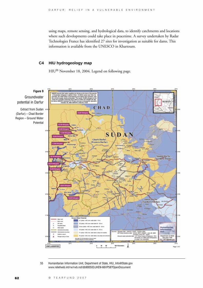
62 © T E A R F U N D 2 0 0 7
D A R F U R : R E L I E F I N A V U L N E R A B L E E N V I R O N M E N T
using maps, remote sensing, and hydrological data, to identify catchments and locations where such developments could take place in peacetime. A survey undertaken by Radar Technologies France has identified 27 sites for investigation as suitable for dams. This information is available from the UNESCO in Khartoum.
C4 HIU hydrogeology map
HIU55 November 18, 2004. Legend on following page.
Figure 9
Groundwater potential in Darfur
Extract from Sudan (Darfur) – Chad Border Region – Ground Water
Potential
55 Humanitarian Information Unit, Department of State, [email protected]/rw/rwb.nsf/db900SID/JHEN-66VP58?OpenDocument

D A R F U R : R E L I E F I N A V U L N E R A B L E E N V I R O N M E N T
63© T E A R F U N D 2 0 0 7
C4.1 Legend
The region can be divided into two groundwater potential categories, good (G) and poor (P) and further sub-divided into units; G1, G2, G3, P1, and P2. The most productive units are G1, G2 and G3. Units P1 and P2 should not be considered as sources of groundwater. (See the bibliography for more specific information.)
UNIT G1: Consists of Quaternary-aged, unconsolidated alluvial deposits of gravels, sands, silts and clay from wadis and rivers of local to sub-regional extent.
Groundwater quality is fresh, as much of it is classified as recently infiltrated surface water from wadi discharge. The depth to the water table is shallow (<10m). Aquifer thickness is expected to be less than 40m, with saturated thicknesses of less than 10m. Transmissivities are high and yields are greater than 400 l/min.
UNIT G2: Consists of coarse-grained sandstones, conglomerates, mudstones, and limestones of the Mesozoic-aged Nubian Sandstone
and Gedaref Formations. Groundwater is generally fresh (total dissolved solids (TDS) < 800 mg/l) and the water table ranges from 25m to 120m below ground surface. Aquifer thickness ranges from 160m to greater than 300m. Transmissivities range from 100 to 3,000 m2/day. Yields are often greater than 400 l/min. The overburden for this unit includes the unconsolidated materials of the Umm Ruwaba Formation (Unit G3). Areas with hatching are dry aquifers.
UNIT G3: Consists of Tertiary-aged unconsolidated and discontinuous layers of sand, silt, and clay of the Umm Ruwaba Formation. Overburden materials
include consolidated sands and clays. Groundwater is found in the saturated sand and conglomerate beds. Thickness rarely exceeds 100m. Depths to the water table vary between 10m to greater than 150m below ground surface. Groundwater quality varies widely, from 100 to more than 5,000 mg/l TDS. Transmissivities are generally low but yields can be greater than 400 l/min.
UNIT P1: Consists of Tertiary-aged undifferentiated volcanics (basalt and trachytes accompanied by tuffs and pumic layers). Overburden materials include
consolidated sands and clays. Groundwater occurs in fractures and faults. Groundwater quality is generally fresh, but thermal saline water may occur. Depth to water and aquifer thicknesses are highly variable. Yields are relatively unknown but are expected to be low (<200 l/min).
UNIT P2: Consists of Precambrian-aged bedrock aquifers composed of schists, gneisses, granites, and rhyolites. The unit is overlain by sedimentary (sandstones
and conglomerates) or igneous rocks that have been folded and intruded by volcanic rocks. Groundwater occurs only in fractures and fault zones. Local perched perennial or ephemeral aquifers may occur, as well as thin saturated layers at depth. Groundwater quality is highly variable but expected to be poor (saline). Depth to water and aquifer thicknesses are unknown. Yields are also relatively unknown but are expected to be low (<200 l/min). This unit should not be considered a source of groundwater.

64 © T E A R F U N D 2 0 0 7
D A R F U R : R E L I E F I N A V U L N E R A B L E E N V I R O N M E N T
C4.2 Water quality terms:
Fresh Total Dissolved Solids (TDS) <= 1,000 mg/lBrackish TDS > 1,000 mg/l but <= 15,000 mg/lSaline TDS > 15,000 mg
C4.3 Bibliography (US Army Corps of Engineers, TEC)
Carte Hydrogeologique de la Republique du Tchad Map, Paris, France: Bureau de Recherches Geologiques et Minieres, 1969.
National Corporation for the Development of Rural Water Resources, Hydrogeologic Map of Sudan: Explanatory Notes, Khartoum, Sudan. 1989.
Salama, Ramsis B, Groundwater Resources of Sudan. Democratic Republic of Sudan, Rural Water Corporation.
United Nations, Groundwater in Africa, New York: Department of Economic and Social Affairs, 1973.
Vennetier, Pierre, Atlas de la Republique Centrafricaine, Paris: Centre National de la Recherche Scientifique.

D A R F U R : R E L I E F I N A V U L N E R A B L E E N V I R O N M E N T
65© T E A R F U N D 2 0 0 7
appendix D Review of three reports on Darfur environment
D1 UNEP PCEA – draft report on Darfur
This study is being undertaken as UNEP are concluding their work on a Post Conflict Environmental Assessment for Sudan. Tearfund collaborated with UNEP on their assessment in Darfur. The interim report for Darfur provides the following list of issues affecting Darfur.
The report describes an ongoing depletion in rainfall and cited this as an underlying cause of conflict for a rural arid land economy such as Darfur. This problem is compounded by unsustainable abstraction or mining of groundwater.
The first impact of land degradation is on food production. The overgrazing and over-cropping with fallow periods have caused the poor soils of Darfur to deteriorate further and consequently yields have deteriorated. This is compounded by soil erosion and desertification. This unsustainable overcropping extends to forestry and is an acute problem around IDP camps. There are also reports of malicious destruction of forestry as part of the conflict.
Traditional environmental governance has broken down under the conditions of conflict. The increase in population and depletion of the resource base are a key component of the conflict, but that is not to deny the significance of the political and ethnic issues.
Water resources • Climate hydrology and hydrogeology data and forecasting
• Unsustainable groundwater extraction
Land degradation • Soil depletion and declining yields
• Soil erosion
• Desertification
Deforestation • General deforestation
• IDP camp linked deforestation
Lack of environmental governance
• Institutional and legislative issues
• Localised breakdown in governance
Linkages between environment, natural resource and conflict
• Shrinking resource base
• Rainfall-led migration (refer to water resources)
• IDP natural resource impact
Urban environmental issues • Water and environmental sanitation and waste management
• Urban planning of evolving settlements
Table 5
UNEP assessment of environmental issues in Darfur

66 © T E A R F U N D 2 0 0 7
D A R F U R : R E L I E F I N A V U L N E R A B L E E N V I R O N M E N T
The temporary nature of IDP camps on the edge of towns was questioned and the need for water and environmental sanitation planning was expressed.
This report is unpublished but available from UNEP on request. It will be superseded by the forthcoming publication of the UNEP PCEA.
D2 Rapid Environmental Assessment at the Kalma Otash and Bajoum Camps56
The joint UNEP/OCHA environment unit undertook an environmental assessment in South Darfur in 2004 using REA methodology. The report recognised the central role of environment in Darfur as follows:
The current, complicated crisis has strong links to environmental and natural resource issues, a fact that must be reflected in humanitarian response and rehabilitation efforts.
For example, competition over land and water between sedentary farmers and nomadic tribes has long been a part of Darfur’s history. Environmental degradation, desertification in northern Sudan and the impacts of prolonged droughts exacerbated the situation, however, causing nomadic groups to move further south in search of suitable land and water. This intensified friction with farmers in Darfur’s more fertile agricultural belt and contributed to the current crisis. Related factors that compound environmental issues include poverty and underdevelopment.
Environmental impacts are also expected where the movement of large numbers of people is involved. For example, refugee populations can contribute to soil erosion and deforestation. Greater impacts are also expected where background natural resources conditions are poor. In the case of refugees, the United Nations High Commissioner for Refugees (UNHCR) recognizes that environmental considerations must be integrated into operations and planning to ensure both environmental quality, and the well being of human populations.
The findings of the report came in three distinct groups:
● Environmental problems, including water and waste management issues, are emerging in some camps, notwithstanding the availability of solutions.
● Environmental considerations and available solutions are not consistently integrated into relief efforts, which undermines their effectiveness.
● A relief assistance gap forces IDPs to deplete natural resources to survive, with significant humanitarian and environmental consequences.
The report recommends measures to reduce environmental impacts of the Darfur crisis, thereby improving the lives and welfare of IDP camp residents.
The recommendations are summarised as follows:
● Improve safety and sustainability of natural resource collection
• Increase levels of basic food and non-food assistance
• Establish safe zones around camps
56 www.benfieldhrc.org/disaster_studies/rea/Darfur_REA_final.pdf

D A R F U R : R E L I E F I N A V U L N E R A B L E E N V I R O N M E N T
67© T E A R F U N D 2 0 0 7
• Increase in-camp livelihood options for IDPs
• Provide IDPs with milled cereals and quick-to-cook pulses
• Consider providing cash to IDPs in lieu of food and non-food items or as income for camp-based work in urban and peri-urban areas to reduce relief needs and increase options to meet needs in the market, rather than from natural resources
• Develop a comprehensive approach to cooking and stove provision.
● Integrate environment into programmes and activities
• Consistently apply existing solutions
• Camp-specific assessments. In-depth environmental impact assessments should be conducted in more camps in Darfur. IDPs should be involved in all assessments and resultant planning.
● Enhance capacity for environmental activities
• Increase environmental field support using United Nations Volunteers
• Establish environmental focal points
• Establish camp level IDP groups to monitor environmental conditions and advise on progress in addressing issues identified in the assessment.
● Upcoming Issues: returning IDPs
• Ensure environment is a core element of return/resettlement plans
• Establish camp and programme-level return/resettlement environmental working groups
• Resettlement and return plans and projects should undergo a rapid environmental impact screening.
D3 Environmental Degradation as a cause of conflict in Darfur57
In late 2004 the UN ‘University for Peace’ held a conference on Environmental Degradation and the Conflict in Darfur. The meeting sought to examine the nature of environmental stress and conflict, and explore development goals that might reduce conflict.
Contributors outlined how drought, farming and herding practices, and the need for woodfuel have all led to a decrease in land productivity and stress on local livelihoods. One of the outcomes has been heightened competition between herders and farmers. The issue of land tenure, and the contradictions between Darfur’s time-tested customary practices and the succession of formal Sudanese land laws promulgated since the early 1970s.
The conference concluded that ‘the people of Darfur [had not had] the chance to discuss their problems in a free and democratic atmosphere’ (p19), including at the Abuja peace talks. This is of special concern given that the conference’s recommendations made it clear that serious preventive and corrective measures were needed to ‘rescue the ecosystem from complete deterioration’ and keep Darfur from passing the ‘point of no return’ (p20).
57 www.steinergraphics.com/pdf/darfur_screen.pdf#search=%22environmental%20degradation%20source%20conflict%20darfur%22

68 © T E A R F U N D 2 0 0 7
D A R F U R : R E L I E F I N A V U L N E R A B L E E N V I R O N M E N T
appendix E Climate change
E1 Impacts of climate change
Darfur lies in a region that suffers and will continue to suffer significant impacts of climate change. It is a physically marginal area already subject to considerable climatic variability and unpredictability. It is at the centre of a large continent which reduces the stabilising effect of the sea currents on temperatures. Globally temperatures have risen by 0.7oC since around 1900. A rise of between 1.4oC and 5.8oC is predicted between 1990 and 2100.58
Figure 10
Change in length of growing period
2000–202059
58 Intergovernmental panel for Climate Change 2001: www.grida.no/climate/ipcc_tar/ and specifically on temperature changes: www.grida.no/climate/ipcc_tar/wg1/008.htm
59 Thornton PK, Jones PG, Owiyo TM, Kruska RL, Herrero M, Kristjanson P, Notenbaert A, Bekele N and Omolo A, with contributions from Orindi V, Otiende B, Ochieng A, Bhadwal S, Anantram K, Nair S, Kumar V, and Kulkar U (2006). Mapping Climate Vulnerability and Poverty in Africa. Report to the Department of International Development, ILRI, PO Box 30709, Nairobi 00100, Kenya, p51: www.napa-pana.org/extranapa/UserFiles/File/Mapping_Vuln_Africa.pdf

D A R F U R : R E L I E F I N A V U L N E R A B L E E N V I R O N M E N T
69© T E A R F U N D 2 0 0 7
Climate models predict that in Darfur the length of growing periods will reduce and the percentage of failed harvests will increase. Predictions include a reduction in the length of growing period ranging from five per cent to 20 per cent from South to North Darfur
by 2020 compared to 2000 levels (see Figure 10) and more than 20 per cent for most of central Darfur by 2050.60 Increasing variability is causing a rise in the percentage of failed harvests.61 UNDP have analysed the impact of climate change on cereal productivity and predict an impact of reduction of greater than 25 per cent across the whole of central Darfur by 2080.
E2 Vulnerability to climate change
Darfur’s physical vulnerability to climate change is compounded by its social and economic vulnerability.62 High dependence on environmental resources transfers climatic vulnerability to the whole economy. In addition, poverty means there is less ability to respond to the direct and indirect effects of climate change. Poverty comprises limited human, institutional and financial capacity. The collapse of environmental governance in Darfur further undermines adaptation capacity.
E3 Adaptation
Adaptation63 is the development response to the impacts of climate change. In vulnerable areas measures are needed to respond to increasing droughts, shorter growing periods etc.
The recent Stern report makes the following recommendation: ‘Adaptation actions should be integrated into development policy and planning at every level. This will incur incremental adaptation costs relative to plans that ignore climate change. But ignoring climate change is not a viable option – inaction will be far more costly than adaptation.’64
On the ground, adapting to climate change means increasing the priority of disaster risk reduction,65 drought cycle management, water resource management, combating deforestation and desertification and developing sustainable and equitable environmental governance. Water resource management needs investment in effective management capacity, hafirs, sand dams, rainwater harvesting etc.
60 Ibid. p48.
61 Ibid. p66.
62 See the Tearfund/IDS report Adapting to climate change p7 www.tearfund.org/webdocs/website/Campaigning/policy%20and%20research/Adapting%20to%20climate%20change%20discussion%20paper.pdf
63 Mitigation in terms of climate change is the effort to reduce the effects by addressing the underlying cause of the problem – by reducing greenhouse gas emissions. In Darfur mitigation would comprise reducing deforestation.
64 www.hm-treasury.gov.uk/media/999/76/
65 A broad introduction and useful list of references on both climate change and disaster risk reduction is available at www.unisdr.org/eng/risk-reduction/climate-change/on-better-terms/On-better-terms.pdf

70 © T E A R F U N D 2 0 0 7
D A R F U R : R E L I E F I N A V U L N E R A B L E E N V I R O N M E N T
Stern identifies the following categories of adaptation:66
● Technology transfer – water resource management, combating desertification agricultural technology etc.
● Human capital: health and education to empower communities to respond to the new environmental dynamics that they face.
● Physical capital: appropriate infrastructure, eg sand dams; appropriate land zoning etc.
● Social capital: security, environmental management; good governance; traditional and kinship relationships that promote peace.
● Natural capital: shelter belts, protected forestry, well managed rangeland.
Practically adaptation actually requires the implementation of approaches that are already current as development priorities (eg disaster risk reduction, water resource management).
E4 The humanitarian context
In the current context of insecurity and humanitarian disaster, a specific focus on adaptation to climate change is not appropriate. This report has argued for SRM as a priority to ensure that the humanitarian response is not undermined by resource depletion. SRM should also be seen as foundational to Darfur’s recovery, development and climate change adaptation priorities.
66 www.hm-treasury.gov.uk/media/999/76/

D A R F U R : R E L I E F I N A V U L N E R A B L E E N V I R O N M E N T
71© T E A R F U N D 2 0 0 7

72 © T E A R F U N D 2 0 0 7
D A R F U R : R E L I E F I N A V U L N E R A B L E E N V I R O N M E N T


Darfur: Relief in a vulnerable environment
Authors: Brendan Bromwich, Dr Abuelgasim Abdalla Adam,Dr Abduljabbar Abdulla Fadul, Florence Chege, Jim Sweet,
Victor Tanner, Geoff Wright
Editing: Rachel Dodd, Eleanor Axcell
Cover photo: Brendan Bromwich / Tearfund
Tearfund contact: Brendan [email protected]
© Tearfund March 2007
Tearfund is an evangelical Christian relief and developmentagency working with local partners to bring help and hope to communities in
need around the world.
Funded by: Department for International Development, UK Government (DFID)
Office of Foreign Disasters Assistance, US Goverment (OFDA)United Nations High Commission for Refugees (UNHCR)
www.tearfund.org
100 Church Road, Teddington, Middlesex, TW11 8QE, UK
Tel: +44 (0)20 8977 9144
Registered Charity No. 265464
7999-(0307)