Relatório RISCO_CEMITÉRIO
96
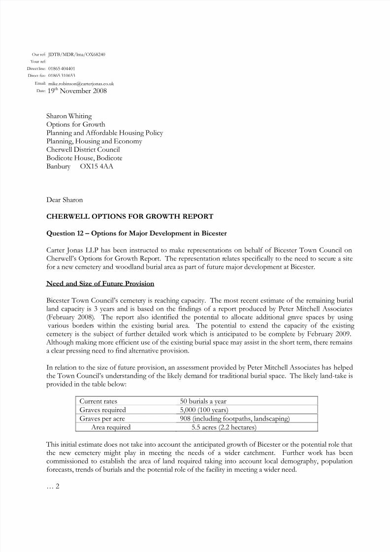
Our ref: JDTB/MDR/lma/OX68240 Your ref: Direct line: 01865 404401 Direct fax: 01865 310653 Email: [email protected] Date: 19 th November 2008 Sharon Whiting Options for Growth Planning and Affordable Housing Policy Planning, Housing and Economy Cherwell District Council Bodicote House, Bodicote Banbury OX15 4AA Dear Sharon CHERWELL OPTIONS FOR GROWTH REPORT Question 12 – Options for Major Development in Bicester Carter Jonas LLP has been instructed to make representations on behalf of Bicester Town Council on Cherwell’s Option s for Growth Repo rt. The representation r elates specifically to the need to secur e a site for a new cemetery and woodland burial area as part of future major development at Bicester. Need and Size of Future Provision Bicester Town Council’s cemete ry is reaching capacity. The most recent estimate of the remaining burial land capacity is 3 years and is based on the findings of a report produced by Peter Mitchell Associates (February 2008). The report also iden tified the potent ial to allocate additional gr ave spaces by using various border s within the existing b urial area. The potential to ex tend the capacity of t he existing cemetery is the subject of further detailed work which is anticipated to be complete by February 2009. Although making more efficient use of the existing burial space may assist in the short term, there remains a clear pressing need to find alternative provision. In relation to the size of future provision, an assessment provided by Peter Mitchell Associates has helped the Town Council’s unde rstanding of the likely demand for traditio nal burial space. The likely land-take is provided in the table below: Current rates 50 burials a year Graves required 5,000 (100 years) Graves per acre 908 (including footpaths, landscaping) Area required 5.5 acres (2.2 hectares) This initial estimate does not take into account the anticipated growth of Bicester or the potential role that the new cemetery might play in meet ing the needs of a w ider catchment. Further work has been commissioned to establish the area of land required taking into account local demography, population forecasts, trends of burials and the potential role of the facility in meeting a wider need. … 2
-
Upload
mauro-cesar -
Category
Documents
-
view
219 -
download
0
Transcript of Relatório RISCO_CEMITÉRIO
8/3/2019 Relatório RISCO_CEMITÉRIO
http://slidepdf.com/reader/full/relatorio-riscocemiterio 1/96
Our ref: JDTB/MDR/lma/OX68240
Your ref:
Direct line: 01865 404401
Direct fax: 01865 310653
Email: [email protected]
Date: 19th
November 2008
Sharon Whiting Options for GrowthPlanning and Affordable Housing Policy Planning, Housing and Economy Cherwell District CouncilBodicote House, BodicoteBanbury OX15 4AA
Dear Sharon
CHERWELL OPTIONS FOR GROWTH REPORT
Question 12 – Options for Major Development in Bicester
Carter Jonas LLP has been instructed to make representations on behalf of Bicester Town Council onCherwell’s Options for Growth Report. The representation relates specifically to the need to secure a sitefor a new cemetery and woodland burial area as part of future major development at Bicester.
Need and Size of Future Provision
Bicester Town Council’s cemetery is reaching capacity. The most recent estimate of the remaining burialland capacity is 3 years and is based on the findings of a report produced by Peter Mitchell Associates(February 2008). The report also identified the potential to allocate additional grave spaces by using
various borders within the existing burial area. The potential to extend the capacity of the existing cemetery is the subject of further detailed work which is anticipated to be complete by February 2009.
Although making more efficient use of the existing burial space may assist in the short term, there remainsa clear pressing need to find alternative provision.
In relation to the size of future provision, an assessment provided by Peter Mitchell Associates has helpedthe Town Council’s understanding of the likely demand for traditional burial space. The likely land-take isprovided in the table below:
Current rates 50 burials a yearGraves required 5,000 (100 years)Graves per acre 908 (including footpaths, landscaping)
Area required 5.5 acres (2.2 hectares)
This initial estimate does not take into account the anticipated growth of Bicester or the potential role thatthe new cemetery might play in meeting the needs of a wider catchment. Further work has been
commissioned to establish the area of land required taking into account local demography, populationforecasts, trends of burials and the potential role of the facility in meeting a wider need.
… 2

8/3/2019 Relatório RISCO_CEMITÉRIO
http://slidepdf.com/reader/full/relatorio-riscocemiterio 2/96
Page 2
The Town Council is keen to acquire a site of about 10 acres (4 hectares) to provide a woodland burialarea in association with the new cemetery. The woodland area could relate to a wider area of community
‘green space’ which could include other uses such as informal recreation and nature conservation.
Location of Future Provision
Given the size of site required to meet the long term future needs of Bicester, the area of search hasfocused on the periphery of the town.
The Town Council commissioned Applied Geotechnical Engineering to undertake preliminary investigations of the ground conditions around Bicester.
Their report (October 2006) concluded that the site where the ground conditions would appear most
appropriate was in the vicinity of Middle Wretchwick, south-east Bicester, located on Oxford Clay. Thereport stated that other sites on the north-east and north-west of the town could also be acceptablelocations.
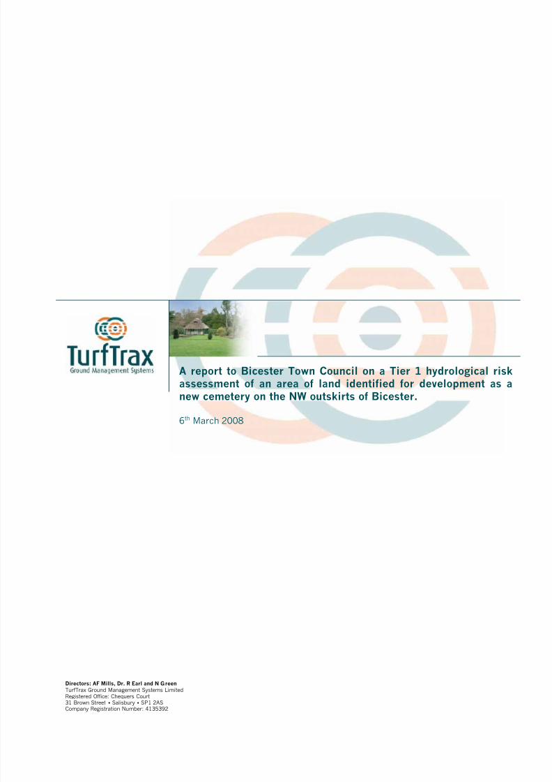
In January 2008, the Town Council appointed specialist consultants TurfTrax Ground ManagementSystems to advise further on the suitability of potential sites. In order to assess risk to the environmentfrom the proposed cemetery, the Environment Agency (EA) requires (as a minimum) a Tier 1hydrological risk assessment.
As well as site geology and hydrogeology, the number of burials in a proposed cemetery will affect theoverall assessment of the environmental risk. Thus a site considered low risk in terms of groundwater
vulnerability, automatically becomes a high risk proposal if more than 100 burials are anticipated eachyear.
The summaries of the findings of the Tier 1 reports are set out below –
SE Bicester – ‘Low’ vulnerability ranking (however the numbers of anticipated annual burials gives rise toa Risk Rating of ‘Moderate’).
NW Bicester (2 sites) – ‘Moderate’ vulnerability ranking (however the numbers of anticipated annualburials gives a Risk Rating of ‘High’).
SW Bicester – ‘Moderate’ vulnerability ranking (however the numbers of anticipated annual burial gives aRisk Rating of ‘High’). This is a generalised rating for the whole site and if consideration is given for justthe south east third of the site (overlain by Kellaways Clays), the vulnerability ranking could be reduced to‘Low.’ However, again due to the numbers of anticipated annual burials, the Risk Rating would attract arisk level of ‘Moderate.’
The first two assessments (March 2008) were reviewed by the Environment Agency and in April 2008they confirmed their initial preference would be for the site to the South East of Bicester over the sites tothe North West. The third assessment (July 2008) was reviewed by the Environment Agency and in
August 2008 they confirmed their agreement with the above findings.
Copies of the Tier 1 reports and the Environment Agency’s replies are attached.
… 3

8/3/2019 Relatório RISCO_CEMITÉRIO
http://slidepdf.com/reader/full/relatorio-riscocemiterio 3/96
Page 3
Securing Future Provision
The Town Council’s preferred strategy is to secure a new facility as part of a planned urban extension toBicester. Although this means the location will be on the periphery, the Town Council has a strong preference for a site that is well related to the town, which would have a reasonable access for pedestrians,cyclists and public transport users.
Pursuing a site through the LDF process means that land could potentially be acquired as part of acomprehensive package of developer contributions. The cemetery and woodland burial area has thepotential to be associated with the wider open space, recreation and landscape requirements of any new development.
There have been meetings with the agents representing the various landowners/developers around
Bicester. They accept the principle that a new burial facility needs to be provided as part of the futuregrowth of Bicester and are aware that early delivery is a key requirement. Officers at Cherwell DistrictCouncil have been very supportive of the need for a new burial facility which has been identified as a key issue in the emerging Cherwell LDF. The Town Council welcomes this support and requests that theDistrict Council allocates a site suitable for such a facility as part of any urban extension.
Conclusion
In summary, there is a clear and pressing need for additional burial space in Bicester. The Town Councilconsiders that this need would best be met through the provision of a new cemetery and woodland burialfacility within a new urban extension. Further evidence is being prepared to confirm the capacity of the
existing cemetery and area of land required for provision of a new facility. The new site has the potentialto be associated with the wider open space requirements of any new major development.
It is important in deciding which option should be considered for major development at Bicester, thatCherwell District Council continues to address the need for a new cemetery and woodland burial area andmakes provision accordingly.
Yours sincerely
MIKE ROBINSON BA (Hons), DipTP, MRTPI AssociateFor and on behalf of Carter Jonas
Enc Tier 1 Reports: NW, SW & SE BicesterEnvironment Agency letters of 10th & 11th April and 18th August 2008.
cc: Councillor Debbie PickfordSusan Mackrell – Bicester Town Council.
8/3/2019 Relatório RISCO_CEMITÉRIO
http://slidepdf.com/reader/full/relatorio-riscocemiterio 4/96
A report to Bicester Town Council on a Tier 1 hydrological riskassessment of an area of land identified for development as anew cemetery on the NW outskirts of Bicester.
6th March 2008
Directors: AF Mills, Dr. R Earl and N GreenTurfTrax Ground Management Systems LimitedRegistered Office: Chequers Court31 Brown Street Salisbury SP1 2ASCompany Registration Number: 4135392

8/3/2019 Relatório RISCO_CEMITÉRIO
http://slidepdf.com/reader/full/relatorio-riscocemiterio 5/96
Bicester Town Council
A report to Bicester Town Council
on a Tier 1 hydrological risk assessment of an area of landidentified for development as a new cemetery
on the NW outskirts of Bicester.

8/3/2019 Relatório RISCO_CEMITÉRIO
http://slidepdf.com/reader/full/relatorio-riscocemiterio 6/96
Table of Contents
1 Executive summary 1
2 Introduction 3
3 Site location and description 5
4 Site geology and hydrogeology 6
5 Boreholes 11
6 Water wells 12
7 Indicative flood plains 13
8 Groundwater source protection zones (SPZs) 14
9 Risk assessment 15
10 Discussion and conclusions 17
11 Recommendations 18
12 Contact details 19
13 Appendices 20
BGS Report No. GR 118 892_1 (2008) 21
Publications on drainage and soil management 49
TurfTrax terms and conditions 53
8/3/2019 Relatório RISCO_CEMITÉRIO
http://slidepdf.com/reader/full/relatorio-riscocemiterio 7/96
- 1-
1 Executive summary
Peter Mitchell Associates, on behalf of TurfTrax Ground Management Systems Limited, havecompleted a Tier 1 hydrological risk assessment of land being considered for development asa new cemetery for Bicester. The key issues that have been identified are summarised below.
The Council has identified broad areas of land on the outskirts of the town. This report is aninitial assessment of the identified site to the NW to establish its suitability for use as acemetery. In order to study independent data concerning the site, a Detailed GeologicalAssessment report was commissioned from the British Geological Survey (BGS). ThisAssessment is attached as an appendix to this report and extracts from it have beenincorporated into the text below.
The vulnerability ranking assigned to this site is ‘Moderate’, and the numbers of anticipatedannual burials gives a Risk Rating of ‘High’.
The site characteristics that raised the vulnerability score were:
• Absence of superficial deposits
• High water table
• Aquifer – the area is underlain by a minor aquifer
Subject to appropriate site investigations and agreement with the EA, it may be possible toeither adjust the risk rating of the site or to design measures, such as drainage orspecifications for burials, to mitigate risk to groundwater.
It is recommended that this report and the accompanying BGS report be sent to the EA, and
dialogue should be established with the EA, to ascertain it’s requirements for furtherassessment of this site’s suitability for development as a cemetery.
Subject to the outcome of this dialogue, if detailed site investigations were thought desirable,it is proposed that a specific area for development is identified and that this should be subjectto the following site investigative works:
1. A topographic survey to provide a basis for designing the cemetery and any necessarydrainage infrastructure.
2. An electro-magnetic induction (EMI) survey to provide a basis for establishing the mostappropriate locations for excavating test pits down to a maximum depth of 3.5 m andinstalling a minimum of three dip wells (up to 10 m deep) to monitor ground waterdepth. The EMI data would be shown on the site plan to two different depths (200 mmand 1.2 m).
3. Assessment of the soil profile pits, and to ‘window sample’ material removed during theboring of the dip wells, in terms of the type, condition and physical properties of thesoil exposed. The results will be used to determine factors that may influence theappropriateness of the site for burial purposes and the vulnerability of the environmentto contamination from the proposed development.
4. Monitor the groundwater levels in the dip wells over a winter period, i.e. during the
period of highest rainfall.

8/3/2019 Relatório RISCO_CEMITÉRIO
http://slidepdf.com/reader/full/relatorio-riscocemiterio 8/96
- 2-
5. Determine any appropriate options for mitigating risk to ground and surface water byimproving the surface and subsurface drainage status.
Depending upon the results of this sampling and analysis, it may be possible to use the site as
a cemetery subject to certain restrictions such as the installation of an appropriate drainagescheme.

8/3/2019 Relatório RISCO_CEMITÉRIO
http://slidepdf.com/reader/full/relatorio-riscocemiterio 9/96
- 3-
2 Introduction
This report is an initial assessment of a broad area of land on the NW outskirts of Bicesterwith respect to it’s suitability for use as a cemetery.
Whilst definitive data regarding the pollution from cemeteries is scarce, any planningapplication for a new cemetery will be assessed by the local Environment Agency (EA) teamagainst their Research and Development Technical Report P223 published in 1999 entitled‘Pollution Potential of Cemeteries – Draft Guidance’. The approach to risk assessmentadopted by the report can be summarised by the following excerpt:
“in order to be able to provide guidance which will enable Environment Agency staff to adopt aconsistent approach when assessing the risks associated with the development of human or animalburial grounds. The guidance is directed principally at the potential threats to groundwater resources,but account is taken also of possible risks to surface waters, soils and the atmosphere” 1
The report provides a framework for assessing the risks associated with cemeteries. The firststage is a ‘Tier One’ preliminary site assessment that provides an initial review of the potentialpathways for contamination and receptors in proximity to the site.
The P233 report sets out the likely types and quantities of pollutants released by the burial ofhuman bodies. The key to whether a site would be considered suitable is the rate at whichsuch pollutants would be transported through the ground to enter water supplies:
“Pathways which pose the greatest threat to groundwaters from dissolved and particulatecontaminants are those where hydrogeological factors allow rapid movement of pollutants from thesource to the groundwater…
Consequently, coarse granular or heavily fractured sub-soils, fissured aquifer materials, or those of restricted mineralogy, are unlikely to offer significant opportunities for attenuation by many of theprocesses…By contrast, aquifers composed of sediments or rocks of mixed mineralogy and in whichgroundwater flows are irregular, provide more effective protection of groundwater from surfacederived pollution.”2
The EA’s Technical Report P223 identifies that the number of burials in a proposed cemeterywill affect the overall assessment of the environmental risk. Thus a site considered low risk interms of groundwater vulnerability, automatically becomes a high risk proposal if more than100 burials are anticipated each year. This relationship between vulnerability class, burial
rates and level of risk is shown schematically in Figure 5.2 of P223, featured later in thisreport.
1 P223 page 12 P223 page 30

8/3/2019 Relatório RISCO_CEMITÉRIO
http://slidepdf.com/reader/full/relatorio-riscocemiterio 10/96
- 4-
The first step in considering any proposed cemetery site at Bicester should therefore be toassess it against a groundwater vulnerability ranking chart (Table 1):
Table 1. Groundwater Vulnerability Ranking Chart (Table 5.1 in P223)
Ranking Very Low Low Moderate High Very High
Drift type Clay Silt Silty sand Sand / gravel Absent
Driftthickness
>5m >3 – 5m 3m 0 – 3m Absent
Depth towater table
>25m 11 – 25m 10m 5 – 9m < 5m
Flowmechanism
Intergranular Fissured
Aquifer Non-aquifer Minor aquifer Major aquifer
Abstractionand SourceProtectionZone
Outside Zone111
Within Zone111
Close toboundary ofZones 11 &
111
Within Zone11
Within Zone 1or <250m
from privatesource
Watercoursesand springs
>100m >70 <100m >50 <70m >30m <50m <30m
Drains >100m >40 <100m 30 – 40m >10 <30m <10m
A scoring scheme (Table 2) is used to provide a comparison mechanism:
Table 2. Scoring scheme for Tier 1 risk assessments
Vulnerability Element score Total score (Range)
Very low 2 – 1 16 – 8
Low 4 – 3 32 -24
Moderate 6 – 5 48 – 40
High 8 – 7 64 – 56
Very high 10 – 9 80 – 72
Using this system, a total score (range) for vulnerability class can be obtained for each site:
Table 3. Vulnerability class for Tier 1 risk assessments
Low vulnerability 8 – 32
Moderate vulnerability 32 – 56
High Vulnerability 56 – 80
The vulnerability class is then considered in the light of burial rates and an overall level of riskprojected. In order to study independent data concerning the site, a Detailed GeologicalAssessment report was commissioned from the British Geological Survey (BGS). ThisAssessment is attached as an appendix to this report and diagrams and text extracts from ithave been incorporated into the text below.

8/3/2019 Relatório RISCO_CEMITÉRIO
http://slidepdf.com/reader/full/relatorio-riscocemiterio 11/96
- 5-
3 Site location and description
There are two potential sites located on the NW outskirts of Bicester as shown below:
Figure 1. Site location plan.
Figure 2. Site aerial view.
The land is predominantly under agricultural use with a relatively small area occupied bybuildings. It is traversed by a stream and a railway line. The slope and principal drainagedirection is to the south-east. The drainage is dendritic in pattern and tributaries run in otherdirections.
Site elevation ranges from 75 metres above Ordnance Datum (OD) in the stream valley in thesouth to 120 m in the north-west of the search area.
8/3/2019 Relatório RISCO_CEMITÉRIO
http://slidepdf.com/reader/full/relatorio-riscocemiterio 12/96
- 6-
4 Site geology and hydrogeology
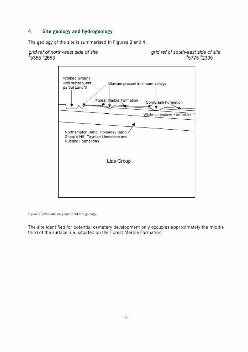
The geology of the site is summarised in Figures 3 and 4.
Figure 3. Schematic diagram of NW site geology.
The site identified for potential cemetery development only occupies approximately the middlethird of the surface, i.e. situated on the Forest Marble Formation.
8/3/2019 Relatório RISCO_CEMITÉRIO
http://slidepdf.com/reader/full/relatorio-riscocemiterio 13/96
- 7-
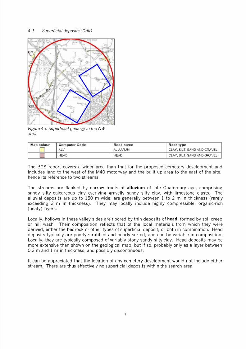
4.1 Superficial deposits (Drift)
Figure 4a. Superficial geology in the NW area.
The BGS report covers a wider area than that for the proposed cemetery development andincludes land to the west of the M40 motorway and the built up area to the east of the site,hence its reference to two streams.
The streams are flanked by narrow tracts of alluvium of late Quaternary age, comprisingsandy silty calcareous clay overlying gravelly sandy silty clay, with limestone clasts. Thealluvial deposits are up to 150 m wide, are generally between 1 to 2 m in thickness (rarelyexceeding 3 m in thickness). They may locally include highly compressible, organic-rich(peaty) layers.
Locally, hollows in these valley sides are floored by thin deposits of head, formed by soil creepor hill wash. Their composition reflects that of the local materials from which they werederived, either the bedrock or other types of superficial deposit, or both in combination. Head
deposits typically are poorly stratified and poorly sorted, and can be variable in composition.Locally, they are typically composed of variably stony sandy silty clay. Head deposits may bemore extensive than shown on the geological map, but if so, probably only as a layer between0.3 m and 1 m in thickness, and possibly discontinuous.
It can be appreciated that the location of any cemetery development would not include eitherstream. There are thus effectively no superficial deposits within the search area.
8/3/2019 Relatório RISCO_CEMITÉRIO
http://slidepdf.com/reader/full/relatorio-riscocemiterio 14/96
- 8-
4.2 Rockhead depth
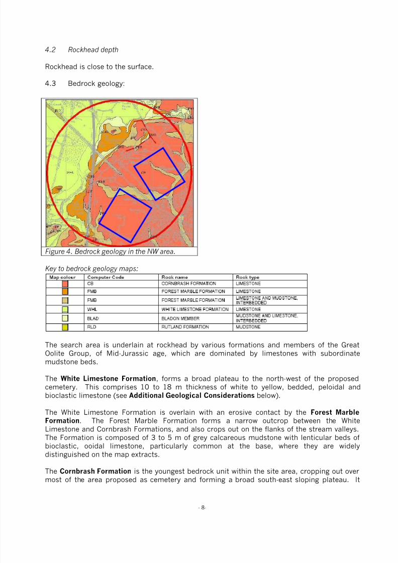
Rockhead is close to the surface.
4.3 Bedrock geology:
Figure 4. Bedrock geology in the NW area.
Key to bedrock geology maps:
The search area is underlain at rockhead by various formations and members of the GreatOolite Group, of Mid-Jurassic age, which are dominated by limestones with subordinatemudstone beds.
The White Limestone Formation, forms a broad plateau to the north-west of the proposedcemetery. This comprises 10 to 18 m thickness of white to yellow, bedded, peloidal andbioclastic limestone (see Additional Geological Considerations below).
The White Limestone Formation is overlain with an erosive contact by the Forest MarbleFormation. The Forest Marble Formation forms a narrow outcrop between the WhiteLimestone and Cornbrash Formations, and also crops out on the flanks of the stream valleys.The Formation is composed of 3 to 5 m of grey calcareous mudstone with lenticular beds ofbioclastic, ooidal limestone, particularly common at the base, where they are widelydistinguished on the map extracts.
The Cornbrash Formation is the youngest bedrock unit within the site area, cropping out overmost of the area proposed as cemetery and forming a broad south-east sloping plateau. It
8/3/2019 Relatório RISCO_CEMITÉRIO
http://slidepdf.com/reader/full/relatorio-riscocemiterio 15/96
- 9-
comprises about 3 m thick grey to brown bioclastic shelly rubbly-bedded limestone with thinsubordinate beds of grey mudstone.
Mudstone beds in the Forest Marble Formation may be unstable on steep slopes or inexcavations.
The limestone-dominated units of the White Limestone, Forest Marble and CornbrashFormations may be affected by dissolution leading to the widening of joints and the formationof linear vertical voids, which are likely to fill with rubble and soil.
Additional geological considerations:
The White Limestone Formation is underlain by four further formations of the Great OoliteGroup: in ascending order the Horsehay Sand, the mudstone-dominated Sharp’s Hill, theTaynton Limestone and the mudstone-dominated Rutland formations, totalling about 20 m inthickness. These are underlain by the 2 to 6 m of the ferruginous sandstones of the
Northampton Sand Formation. Beneath these are over 100 m of the mudstone-dominatedLias Group.
The bedrock strata dip very gently (less than 0.5°) to the south-east. Faults have beenmapped to the north-east of Bucknell, beyond the proposed cemetery development, withdisplacements of up to about 5 m. It is important to understand the nature of geologicalfaults, and the uncertainties which attend their mapped position at the surface. Faults areplanes of movement, along which, adjacent blocks of rock strata have moved relative to eachother. They commonly consist of zones, perhaps up to several tens of metres wide, containingseveral to many fractures. The portrayal of such faults as a single line on the geological mapis therefore a generalisation. Geological faults in this area are of ancient origin, are todaymainly inactive, and are thought to present no threat to property.
8/3/2019 Relatório RISCO_CEMITÉRIO
http://slidepdf.com/reader/full/relatorio-riscocemiterio 16/96
- 10-
4.4 Hydrogeology:
With the exception of the Forest Marble Formation cropping out in the floors and sides of thevalleys, the whole of the site area is underlain by Cornbrash Formation bedrock. This is a localaquifer and several water strikes have been recorded in shallow, site-investigation boreholes
drilled within the site area. The rest water levels are generally slightly higher than the strikelevels; both are generally between about 0.5 and 4.0 m below the ground surface.
The Forest Marble Formation, where present beneath the area, may hold small quantities ofwater in any limestone bands present, but the upper part generally acts as an aquicludebetween the Cornbrash Formation and the underlying White Limestone Formation. There areno boreholes drilled through the Forest Marble Formation in the site area that record waterstrikes within it.
The White Limestone Formation constitutes a major aquifer in the area, with some sources ofpublic supply. There are several boreholes in the wider area, some within the site area, that
penetrate this formation:
• A 34 m deep borehole at Gowell Farm (SP52/19 at SP 5709 2384), drilled pre-1909 tosupply Bicester with water, penetrated the complete 25 m thickness of the WhiteLimestone Formation, underlying about 7.2 m of Forest Marble Formation andterminating in the underlying Rutland Formation. Water was struck at 28 m and 32 mbelow the ground level in the White Limestone Formation. The rest water level rose tothe surface after the first strike, and was artesian, with a rest water level about 1 mabove ground level (about 88 m above OD) after the second strike. The yield was over7 l/s.
• An 80 m deep borehole at Lords Farm (SP52/18 at SP 5746 2424), drilled in 1941,was drilled through a similar sequence and terminated in the Lias. It struck water inthe Cornbrash Formation, which was cased out, and at two levels below the WhiteLimestone Formation. The rest water level was at 11 m below ground level (about 68 mabove OD) and it yielded 1.7 l/s.
• Other records of water levels at Lords Farm (SP52/17A, B and C at about SP 569 245)show that the water level was at within 3.6 m below ground level (about 76 m aboveOD).
There are insufficient data to determine a groundwater flow direction, but locally it willprobably be towards the nearest stream and regionally, down-dip towards the south-east.
The alluvium, and Cornbrash and Forest Marble Formations beneath the site are classified asMinor Aquifers with high soil leaching potential on the Environment Agency's GroundwaterVulnerability Map, Sheet 30, Northern Cotswolds.

8/3/2019 Relatório RISCO_CEMITÉRIO
http://slidepdf.com/reader/full/relatorio-riscocemiterio 17/96
- 11-
5 Boreholes
The plan below shows the location of boreholes relative to the proposed cemeterydevelopment:
Figure 5. Site location, boreholes and watercourses.
The BGS report includes an extensive table referring to these boreholes.
8/3/2019 Relatório RISCO_CEMITÉRIO
http://slidepdf.com/reader/full/relatorio-riscocemiterio 18/96
- 12-
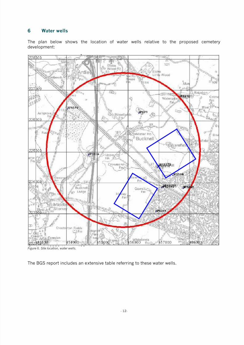
6 Water wells
The plan below shows the location of water wells relative to the proposed cemeterydevelopment:
Figure 6. Site location, water wells.
The BGS report includes an extensive table referring to these water wells.

8/3/2019 Relatório RISCO_CEMITÉRIO
http://slidepdf.com/reader/full/relatorio-riscocemiterio 19/96
- 13-
7 Indicative flood plains
According to the EA’s website, the NW of Bicester lies outside any indicative flood plain (Figure6).
Figure 6. Environment Agency website flood risk map.
8/3/2019 Relatório RISCO_CEMITÉRIO
http://slidepdf.com/reader/full/relatorio-riscocemiterio 20/96
- 14-
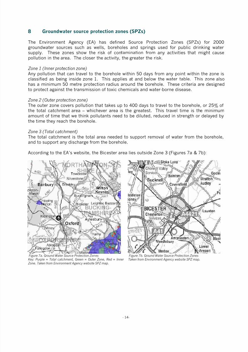
8 Groundwater source protection zones (SPZs)
The Environment Agency (EA) has defined Source Protection Zones (SPZs) for 2000groundwater sources such as wells, boreholes and springs used for public drinking watersupply. These zones show the risk of contamination from any activities that might cause
pollution in the area. The closer the activity, the greater the risk.
Zone 1 (Inner protection zone)
Any pollution that can travel to the borehole within 50 days from any point within the zone isclassified as being inside zone 1. This applies at and below the water table. This zone alsohas a minimum 50 metre protection radius around the borehole. These criteria are designedto protect against the transmission of toxic chemicals and water-borne disease.
Zone 2 (Outer protection zone)
The outer zone covers pollution that takes up to 400 days to travel to the borehole, or 25% ofthe total catchment area – whichever area is the greatest. This travel time is the minimum
amount of time that we think pollutants need to be diluted, reduced in strength or delayed bythe time they reach the borehole.
Zone 3 (Total catchment)
The total catchment is the total area needed to support removal of water from the borehole,and to support any discharge from the borehole.
According to the EA’s website, the Bicester area lies outside Zone 3 (Figures 7a & 7b):
Figure 7a. Ground Water Source Protection ZonesKey: Purple = Total catchment, Green = Outer Zone, Red = Inner
Zone. Taken from Environment Agency website SPZ map.
Figure 7b. Ground Water Source Protection ZonesTaken from Environment Agency website SPZ map.

8/3/2019 Relatório RISCO_CEMITÉRIO
http://slidepdf.com/reader/full/relatorio-riscocemiterio 21/96
- 15-
9 Risk assessment
9.1 Site Vulnerability Assessment
Pertinent criteria, associated comment and assigned score are presented in Tables 4 and 5.
Table 4. Site vulnerability criteria and comment Criteria Comment
Drift Type Absent
Drift Thickness N/A
Depth to Water Table 0.5m to 4m
Flow Mechanism Fracture Flow
Aquifer Minor aquifer
Abstraction and SPZ Outside SPZ 3
Watercourses and springs >100 (subject to precise location within the identified area
Drains None known to be present
Table 5. Site vulnerability assessment score sheet
Factor Site Characteristics Ranking Score
Drift type Absent Very High 10 - 9
Drift thickness N/A Very High 10 - 9
Depth to water table 0.5m to 4m Very High 10 - 9
Flow mechanism Fracture Flow Very High 10 - 9
Aquifer Minor aquifer Moderate 6 - 5
Abstraction and Source Protection Zone Outside SPZ 3 Very Low 2 - 1
Watercourses and springs >100m Very Low 2 - 1
Land Drains None known to be present Very Low 2 - 1
Total (range) 52 - 44
Vulnerability Range Actual
Low vulnerability 8 – 32
Moderate vulnerability 32 – 56 44 - 52
High Vulnerability 56 – 80
9.2 Vulnerability Class
Based upon the total ranking score indicated, the site may be classified with a vulnerabilityclass of:
Low: Moderate: X High:
9.3 Scale of Development
The anticipated number of annual full earth burials, as opposed to cremated remains, is 50.

8/3/2019 Relatório RISCO_CEMITÉRIO
http://slidepdf.com/reader/full/relatorio-riscocemiterio 22/96
- 16-
9.4 Level of Risk
The EA level of risk to the number of anticipated burial rates and groundwater vulnerabilityusing a nomograph reproduced in Figure 8.
Figure 8. Schematic relationship between burial rates, vulnerability class and level of risk (from EA R & D Technical Report P223(1999).
With reference to Figure 8, the level of risk at this site is considered to be ‘High’.
50 bodies per year

8/3/2019 Relatório RISCO_CEMITÉRIO
http://slidepdf.com/reader/full/relatorio-riscocemiterio 23/96
- 17-
10 Discussion and conclusions
The vulnerability ranking assigned to this site is ‘Moderate’, however the numbers ofanticipated annual burials gives rise to a Risk Rating of ‘High’.
The site characteristics that raised the vulnerability score were:
• Absence of superficial deposits
• High water table
• Aquifer – the site is underlain by a minor aquifer
Applied Geotechnical Engineering excavated a number of trial pits around the Bicester ringroad during June 2006. Two trial pits were located near Lords Farm and revealed rubbly, verythinly bedded limestone with a clayey, sandy matrix down to 1.2 m with a stronger limestonebeneath to 1.9 m (grave depth). Groundwater was not encountered in either trial pit.
There may be significant seasonal fluctuation in groundwater levels as the BGS reportindicates that the watertable may be encountered between 0.5 m and 4 m. It would thereforebe appropriate to install dipwells within the chosen area and monitor groundwater levelsthrough a winter period to monitor levels and possibly reduce the risk rating of the site.
Subject to appropriate site investigations and agreement with the EA, it may be possible toeither adjust the risk rating of the site or to design measures, such as drainage orspecifications for burials, to mitigate any risk to groundwaters.

8/3/2019 Relatório RISCO_CEMITÉRIO
http://slidepdf.com/reader/full/relatorio-riscocemiterio 24/96
- 18-
11 Recommendations
It is recommended that this report and the accompanying BGS report be circulated to the EAand dialogue established to ascertain requirements for further assessment of this site’ssuitability for development as a cemetery.
Subject to the outcome of this dialogue, if detailed site investigations were thought desirable,it is proposed that the site investigation should consist of the following:
1. A topographic survey to provide a basis for designing the cemetery and any necessarydrainage infrastructure.
2. An electro-magnetic induction (EMI) survey to provide a basis for establishing the mostappropriate locations for excavating soil profile pits down to a maximum depth of 3.5 mand installing a minimum of three dip wells (up to 10 m deep) to monitor ground waterdepth. The EMI data would be shown on the site plan to two different depths (200 mm
and 1.2 m).
3. Assessment of the soil profile pits, and to ‘window sample’ material removed during theboring of the dip wells, in terms of the type, condition and physical properties of thesoil exposed. The results will be used to determine factors that may influence theappropriateness of the site for burial purposes and the vulnerability of the environmentto contamination from the proposed development.
4. Monitor the groundwater levels in the dip wells over a winter period, i.e. during theperiod of highest rainfall.
5. Determine any appropriate options for mitigating risk to ground and surface water byimproving the surface and subsurface drainage status.
Depending upon the results of this sampling and analysis, it may be possible to use the site asa cemetery subject to certain restrictions such as the installation of an appropriate drainagescheme.
8/3/2019 Relatório RISCO_CEMITÉRIO
http://slidepdf.com/reader/full/relatorio-riscocemiterio 25/96
- 19-
Confidentiality
This presentation is confidential and is only for the use of officers of Bicester Town Counciland Cherwell District Council (and their representatives). Without the specific consent inwriting of TurfTrax Ground Management Systems Limited, no copies of this presentation are to
be made and information contained herein should not be communicated to any third party. Atthe request of TurfTrax Ground Management Systems Limited all copies of this document, inwhatever form, are to be returned.
12 Contact details
Commercial OfficeChequers Court31 Brown StreetSalisburyWiltshire
SP1 2AS
Tel: 01722 434000Fax: 01722 434040
Technical OfficeUnit 1, Highfield ParcHighfield RoadOakleyBedfordshire
MK43 7TA
Tel: 01234 821750Fax: 01234 821751Email: [email protected]

8/3/2019 Relatório RISCO_CEMITÉRIO
http://slidepdf.com/reader/full/relatorio-riscocemiterio 26/96
- 20-
13 Appendices

8/3/2019 Relatório RISCO_CEMITÉRIO
http://slidepdf.com/reader/full/relatorio-riscocemiterio 27/96
- 49-
Publications by key staff
A guide to better soil structure. Booklet based on MAFF funded project SP0305 “A national soilvulnerability-based framework for the provision of farm-specific guidance on the management of soilstructure”. National Soil Resources Institute, Cranfield University, Silsoe, Bedfordshire, MK45 4DT,September 2001.
Alexandrou, A. & Earl, R. (1998). The relationship between the pre-compaction stress, volumetricwater content and initial dry bulk density of soil. Journal of Agricultural Engineering Research 71, 75-80.
Alexandrou, A & Earl, R. (1997). Development of a technique for assessment the behaviour of soilunder load. Journal of Agricultural Engineering Research 68, 169- 180.
Alexandrou, A. & Earl, R. (1995). In situ determination of the pre-compaction stress of a soil. Journalof Agricultural Engineering Research 61, 67-72.
Bulson, H.A.J., Welsh, J.P., Stopes, C.E. & Woodward, L. (1996). Agronomic viability and potential
economic performance of three organic four year rotations without livestock, 1988-1995. Aspects ofApplied Biology 47: Rotations and cropping systems, 277-286.
Churcher, D.W., Greenwood, J.R., Vickers, A.W. Morgan, R.P.C., Coppin, N.J. & Norris, J.E. (1999). Abioengineering demonstration trial, Kent, England. In: Proceedings 2nd International Conference onLandslides, Slope Stability and the Safety of Infrastructures. ISBN 981-04-1537-0.
S.K. Cook, W.F. Cormack, M. Green, J.M. Holland, A.R. Leake and J.P. Welsh. (2000). Farmingsystems for the new Millennium. Aspects of Applied Biology 62. AAB, Wellesbourne, UK.
Davies, D.H.K. & Welsh, J.P. (2002). Weed control in organic cereals and pulses. In: Organic cerealsand pulses (eds) D Younie, BR Taylor, JP Welsh and JM Wilkinson. Chalcombe Publications, Lincoln,
UK. 77-114.
Earl, R. (1998). Tillage - soil, plant and implement considerations. Landwards 53, 17-23.
Earl, R. (1998). Principles of traction and compaction. Landwards 53, 14-16.
Earl, R. (1997). Prediction of trafficability and workability from soil moisture deficit. Soil and TillageResearch 40, 155-168.
Earl, R. (1997). Assessment of the behaviour of field soils during compression. Journal of AgriculturalEngineering Research 68, 147- 158.
Earl, R. (1996). Prediction of trafficability and workability using tensiometers. Journal of AgriculturalEngineering Research 63, 27-34.
Earl, R., Taylor, J.C., Wood, G.A., Bradley, I.T., Waine, T., Welsh, J.P., Godwin, R.J. & Knight, S.M.(2003). Soil factors and their influence on within-field crop variability, Part I: Field observation of soilvariation. Biosystems Engineering 84(4), 425-440.
Earl, R. & Alexandrou, A. (2001). Deformation processes below a plate sinkage test on sandy loam:theoretical approach. Journal of Terramechanics 38, 153-162.
Earl, R. & Alexandrou, A. (2001). Deformation processes below a plate sinkage test on sandy loam:experimental approach. Journal of Terramechanics 38, 163-183.
Earl, R. & Carter, A.D. (1991). The sampling of water in an unsaturated soil. The Agricultural Engineer46, 50-51.
8/3/2019 Relatório RISCO_CEMITÉRIO
http://slidepdf.com/reader/full/relatorio-riscocemiterio 28/96
- 50-
Earl, R. and Wheeler, P.N. Lined moles cut drainage costs. Arable Farming, June 1993, p 27-32.
Earl, R., Wheeler, P.N., Blackmore, B.S. & Godwin, R.J. (1996). Precision farming - the management ofvariability. Landwards 51(4), 18-23.
Godwin, R.J., Richards, T.E., Wood, G.A., Welsh, J.P. & Knight, S.M. (2003). An economic analysis of
the potential for precision farming in UK cereal production. Biosystems Engineering 84(4), 533-545.
Godwin, R.J., Wood, G.A., Taylor, J.C., Knight, S.M. & Welsh, J.P. (2003). Precision farming of cerealcrops: A review of a six year experiment to develop management guidelines. Biosystems Engineering84(4), 375-391.
Greenwood, J.R., Vickers, A.W., Morgan, R.P.C., Coppin, N.J. & Norris, J.E. (2001). Bioengineering: TheLongham Wood Cutting field trial. CIRIA Project report 81. ISBN 0 86017 881 1.
Gregory, A.S., Kendall, B.A., Earl, R. & Vickers, A.W. (2002). The effects of engineering practices andincorporation of amendments on soil structural development in a clay soil-forming material used as alandfill restoration cap. A report for shanks first fund.
Gregory, A.S. & Vickers, A.W. (2004). The effects of amendments on soil structural development in aclay soil-forming material used as a landfill restoration cap. Soil Use and Management.
Kendall, B.A., Gregory, A.S., Earl, R., & Vickers, A.W. (2001). The effects of engineering practices andamendments on soil structural development in a clay landfill restoration cap. In: Eighth InternationalWaste Management and Landfill Symposium. 1st - 5th October 2001. Sardinia, Italy. Proceedings.Volume 4. pp 371-380.
Morgan, R.P.C., Mcintyre, K., Vickers., A.W.V., Quinton, J.N. & Rickson, R.J. (1997). A rainfallsimulation study of soil erosion on rangeland in Swaziland. Soil Technology 11, 291-299.
Pearce, B.D., Wolfe, M.S. & Welsh, J.P. (2002). Review of knowledge of the potential impacts ofgenetically modified organisms (GMO) on organic agriculture. In: Proceedings of the 14th IFOAM WorldCongress, Canada.
Philipps, L., Welsh, J.P., Bulson, H.A.J. & Woodward, W. (1999). Agronomic viability and potentialeconomic performance of three organic four year rotations without livestock, 1988-1998. Proceedingsof the 12th IFOAM Conference - Organic Agriculture: Credible Solutions for the 21st Century, Argentina.109-115.
J Powell, G Davies, S Fowler, M Hovi, N Lampkin, M Lennartsson, S Padel, B Pearce, L Philipps, JRobertson, E Stockdale, C Watson, R Weller, J Welsh and M Wolfe. (2002). Proceedings of the UKOrganic Research 2002 Conference. Organic Centre Wales, Aberystwyth, UK.
Reeve, M.J. and Earl, R. (1990). The effect of soil strength on agricultural and civil engineering fieldoperations. Soil Survey Report, MAFF Contract 3806.
Schmidt, H., Philipps, L., Welsh, J.P. & Fragstein, P.V. (1999). Legume breaks in stockless organicfarming rotations: Nitrogen accumulation and influence on the following crops. Biological Agricultureand Horticulture 17, 159-170.
Spoor, G., Earl, R. and Wheeler, P.N. (1992). Development of lower cost drainage systems for heavysoils. HGCA Project Report No 64.
Spoor, G, Hann, M J, Godwin, R J, Leeds-Harrison, P B, Miller, S M. (1987). Machinery Developmentsfor Reducing Draught and Improving the Grading Characteristics of Mole Ploughs. ASAE 5th National
Drainage Symposium.

8/3/2019 Relatório RISCO_CEMITÉRIO
http://slidepdf.com/reader/full/relatorio-riscocemiterio 29/96
- 51-
Taylor, J.C., Wood, G.A., Earl, R. & Godwin R.J. (2003). Soil factors and their influence on within-fieldcrop variability, Part II: Spatial analysis and determination of management zones. BiosystemsEngineering 84(4), 441-453.
Taylor, J.C., Wood, G.A., Welsh, J.P. & Knight S. (2000). Exploring management strategies forprecision farming of cereals assisted by remote sensing. Aspects of Applied Biology 60: Remote
Sensing in Agriculture, 53-60.
Thomasson, A.J., Carter, A.D., Jones, R.J.A., Leverton, R.E., Earl, R., Bouma, J., Van Wijk, A.L.M.,Feddes, R.A., Van Lanen, H.A.J., Kabat, P. And Hack-ten Broeke, M.J.D. (1989). Use of modernphysical field methods and computer simulation for land evaluation purposes. Report to EC DG VI,Research Contract No 5711.
Toyne, K. & Vickers, A.W. (2003). Critical evaluation of the ASTM method of measuring percolationrates of rootzones materials. Paper presented at National Turfgrass Foundation National Conference,Southport. November 2003.
Vickers, A.W. & James, I.T. (2003). Management of cracking in clay soils used for cricket pitches.
Paper presented at the Institute of Groundsmanship Annual Conference, Leicester, April 2003.
Vickers, A.W. (2002). Experimental Design for evaluation of products for sportsturf. Paper presented atNational Turfgrass Foundation National Conference, Southport. November 2002.
Vickers, A.W. (2001). Optimisation of rolling on cricket pitches. Paper presented at the 2001 Institute ofGroundsmanship Annual Conference, Haydock.
Vickers, A.W. (2001). Soil water management for sports surfaces. Paper presented at the 2001Institute of Groundsmanship Annual Conference, Haydock.
Vickers, A.W. & Morgan, R.P.C. (1999). Soil water monitoring to assess the effectiveness of three
bioengineering treatments on an unstable Gault Clay cutting in Southern England. In: Proceedings 2ndInternational Conference on Landslides, Slope Stability and the Safety of Infrastructures. ISBN 981-04-1537-0
Vickers, A.W. (1994). A simple field erodibility index based on some English soils. In: Conserving SoilResources, European Perspectives. Edit. R.J. Rickson. CAB International. pp 70 - 78.
Welsh, J.P., Philipps, L. & Cormack, W.F. (2002). The long-term agronomic performance of organicstockless rotations. In: Proceedings of the UK Organic Research 2002 Conference. Organic CentreWales, Aberystwyth, UK. 47-50.
Welsh, J.P., Wolfe, M.S. & Pearce, B.D. (2002). The performance of cereal varieties under organicsystems in on-farm trials in England. In: Proceedings of the 14th IFOAM World Congress, Canada.
Welsh, J.P., Wolfe, M.S., Snape, J. & Pearce, B.D. (2002). Generating and evaluating a novel geneticresource in wheat in diverse environments. In: Proceedings of the 14th IFOAM World Congress, Canada.311.
Welsh, J.P. & Wolfe, M.S. (2002). The performance of variety mixtures and the potential for populationbreeding in organic farming systems. Proceedings of the ECO-PB Symposium: Organic seed production& plant Breeding – strategies, problems and perspectives, Berlin.
Welsh, J.P., Wood, G.A., Godwin, R.J., Taylor, J.C., Earl, R., Blackmore, S. & Knight, S.M. (2003).Developing strategies for spatially variable nitrogen application in cereals, Part I: Winter barley.Biosystems Engineering 84(4), 481-494.

8/3/2019 Relatório RISCO_CEMITÉRIO
http://slidepdf.com/reader/full/relatorio-riscocemiterio 30/96
- 52-
Welsh, J.P., Wood, G.A., Godwin, R.J., Taylor, J.C., Earl, R., Blackmore, S. & Knight, S.M. (2003).Developing strategies for spatially variable nitrogen application in cereals, Part II: Wheat. BiosystemsEngineering 84(4), 495-511.
Welsh, J.P., Bulson, H.A.J., Stopes, C.E., Froud-Williams, R.J. & Murdoch, A.J. (1999). The criticalweed-free period in organically-grown winter wheat. Annals of Applied Biology 134, 315-320.
Welsh JP, Bulson H A J, Philipps L and Wolfe M. (1999). Weed control strategies for organic cerealcrops. Proceedings of the 1999 Brighton Crop Protection Conference – Weeds. 945-950.
Welsh JP, Bulson H A J, Stopes C E, Froud-Williams R J and Murdoch A J. (1997). Mechanical weedcontrol in organic winter wheat. Aspects of Applied Biology 50: Optimising Cereal Inputs - Its ScientificBasis. 375-384.
Welsh JP, Bulson H A J, Stopes C E, Murdoch A J and Froud-Williams R J. (1997). The critical periodof weed competition and its application in organic winter wheat. Proceedings of the 1997 Brighton CropProtection Conference - Weeds. 105-110.
Welsh JP, Bulson H A J, Stopes C E, Froud-Williams R J and Murdoch A J. (1996). Weed control inorganic winter wheat using a spring-tine weeder. Proceedings of the Second International Weed ControlCongress, Copenhagen. 1127-1132
Wood, G.A., Welsh, J.P., Godwin, R.J., Taylor, J.C., Earl, R. & Knight, S.M. (2003). Real-time measuresof canopy size as a basis for spatially varying nitrogen applications to winter wheat sown at differentseed rates. Biosystems Engineering 84(4), 513-531.
D. Younie, B.R. Taylor, J.P. Welsh & J.M. Wilkinson. (2002). Organic Cereals and Pulses. ChalcombePublications, Lincoln, UK.
Zimbone, S.M., Vickers, A.W., Morgan, R.P.C. & Vella, P. (1996). Field investigations of different
techniques for measuring soil surface shear strength. Soil Technology. 9. pp 101 – 111.

8/3/2019 Relatório RISCO_CEMITÉRIO
http://slidepdf.com/reader/full/relatorio-riscocemiterio 31/96
- 53 -
Turftrax Ground Management Systems Limited
Terms and Conditions for the Supply of Services
Interpretation
In these Conditions
AGREED FEE means the charges agreed between TurfTrax and the Client in relation to
the Specified Service
CLIENT means the person named on the Specification Sheet for whom TurfTrax has
agreed to provide the Specified Service in accordance with these Conditions
CONTRACT means the contract for the provision of the Specified Service
DOCUMENT includes, in addition to a document in writing, any map, plan, graph,
drawing or photograph, any film, negative, tape or other device embodying visual images
and any disc, tape or other device embodying any other dataINPUT MATERIAL means any Documents or other materials, and any data or other
information provided by the Client relating to the Specified Service
OUTPUT MATERIAL means any Documents or other materials, and any data or other
information provided by TurfTrax relating to the Specified Service
SPECIFICATION SHEET means the sheet to which these Conditions are appended
SPECIFIED SERVICE means the service relating to geophysical surveys of land to be
provided by TurfTrax for the Client and referred to in the Specification Sheet
TURFTRAX means TurfTrax Ground Management Systems Limited (registered in
England under number 4135392 ) or its subsidiary as stated on the Specification Sheet
The headings in these Conditions are for convenience only and shall not affect their
interpretation.
Supply of the Specified Service
TurfTrax shall provide the Specified Service to the Client subject to these Conditions.
Any changes or additions to the Specified Service or these Conditions must be agreed in
writing by TurfTrax and the Client.
The Client shall allow TurfTrax adequate access to its property at reasonable times and
for so long as is necessary to enable TurfTrax to provide the Specified Service in
accordance with the Contract.
The Client shall at its own expense supply TurfTrax with all necessary Documents orother materials, and all necessary data or other information relating to the Specified
Service, within sufficient time to enable TurfTrax to provide the Specified Service in
accordance with the Contract. The Client shall ensure the accuracy of all Input Material.
TurfTrax shall have no liability for any loss or damage, however caused, to the Input
Material. All Output Material shall be at the sole risk of the Client from the time of
delivery to or to the order of the Client.
The Specified Service shall be provided in accordance with the Specification Sheet
subject to these Conditions.
Further details about the Specified Service, and advice or recommendations about its
provision or utilisation, which are not given in TurfTrax’s brochure or other promotional
literature, may be made available on written request.
TurfTrax may correct any typographical or other errors or omissions in any brochure,
promotional literature, quotation or other document relating to the provision of the
Specified Service without any liability to the Client.
TurfTrax may at any time without notifying the Client make any changes to the Specified
Service which are necessary to comply with any applicable safety or other statutory
requirements, or which do not materially affect the nature or quality of the Specified
Service.Charges
Subject to any special terms agreed, the Client shall pay the Agreed Fee and any
additional sums which are agreed between TurfTrax and the Client for the provision of
the Specified Service or which, in TurfTrax’s sole discretion, are reasonably incurred as a
result of the Client’s instructions or lack of instructions, the inaccuracy of any Input
Material or any other cause attributable to the Client.
All charges quoted to the Client for the provision of the Specified Service are exclusive of
any Value Added Tax, for which the Client shall be additionally liable at the applicable
rate from time to time.
TurfTrax shall be entitled to invoice the Client on completion of the Specified Service.
The Agreed Fee and any additional sums payable shall be paid by the Client (together
with any applicable Value Added Tax, and without any set-off or other deduction) within
30 days of the date of TurfTrax’s invoice.
If payment is not made on the due date, TurfTrax shall be entitled, without limiting any
other rights it may have, to charge interest on the outstanding amount (both before and
after any judgment) at the rate of 4 % above the base rate from time to time of Barclays
Bank plc from the due date until the outstanding amount is paid in full.
Rights in Input Material and Output Material
The property and any copyright or other intellectual property rights in:any Input Material shall belong to the Client
any Output Material and any amendments or variations to the Input Material made by
TurfTrax shall, unless otherwise agreed in writing between the Client and TurfTrax,
belong to TurfTrax, subject only to the right of the Client to use the Output Material for
the purposes of utilising the Specified Service.
Any Input Material or other information provided by the Client which is so designated by
the Client and any Output Material shall be kept confidential by TurfTrax, and all Output
Material or other information provided by TurfTrax which is so designated by TurfTrax
shall be kept confidential by the Client; but the foregoing shall not apply to any
Documents or other materials, data or other information which are public knowledge at
the time when they are so provided by either party, and shall cease to apply if at any
future time they become public knowledge through no fault of the other party.
The Client warrants that any Input Material and its use by TurfTrax for the purpose of
providing the Specified Service will not infringe the copyright or other rights of any third
party, and the Client shall indemnify TurfTrax against any loss, damages, costs, expenses
or other claims arising from any such infringement.
Warranties and Liability
TurfTrax warrants to the Client that the Specified Service will be provided usingreasonable care and skill and, as far as reasonably possible, in accordance with the
Specification and at the intervals and within the times referred to in the Specification
Sheet. Where TurfTrax supplies in connection with the provision of the Specified Service
any goods (including Output Material) supplied by a third party, TurfTrax does not give
any warranty, guarantee or other term as to their quality, fitness for purpose or otherwise,
but shall, where possible, assign to the Client the benefit of any warranty, guarantee or
indemnity given by the person supplying the goods to TurfTrax.
TurfTrax shall have no liability to the Client for any loss, damage, costs, expenses or
other claims for compensation arising from any Input Material or instructions supplied by
the Client which are incomplete, incorrect, inaccurate, illegible, out of sequence or in the
wrong form, or arising from their late arrival or non-arrival, or any other fault of the
Client.
Except in respect of death or personal injury caused by TurfTrax’s negligence, or as
expressly provided in these Conditions, TurfTrax shall not be liable to the Client by
reason of any representation (unless fraudulent), or any implied warranty, condition orother term, or any duty at common law, or under the express terms of the Contract, for
any loss of profit or any indirect, special or consequential loss, damage, costs, expenses or
other claims (whether caused by the negligence of TurfTrax, its servants or agents or
otherwise) which arise out of or in connection with the provision of the Specified Service
or their use by the Client, and the entire liability of TurfTrax under or in connection with
the Contract shall not exceed the amount of TurfTrax’s charges for the provision of the
Specified Service, except as expressly provided in these Conditions.
TurfTrax shall not be liable to the Client or be deemed to be in breach of the Contract by
reason of any delay in performing, or any failure to perform, any of TurfTrax’s
obligations in relation to the Specified Service, if the delay or failure was due to any
cause beyond TurfTrax’s reasonable control.
Termination
Either party may (without limiting any other remedy) at any time terminate the Contract
by giving written notice to the other if the other commits any breach of these Conditions
and (if capable of remedy) fails to remedy the breach within 30 days after being required
by written notice to do so.
Insolvency of Client
This clause applies if:
the Client makes any voluntary arrangement with its creditors or (being an individual orfirm) becomes bankrupt or (being a company) becomes subject to an administration order
or goes into liquidation (otherwise than for the purposes of amalgamation or
reconstruction); or
an encumbrance takes possession, or a receiver is appointed, of any of the property or
assets of the Client; or
the Client ceases, or threatens to cease, to carry on business; or
TurfTrax reasonably apprehends that any of the events mentioned above is about to occur
in relation to the Client and notifies the Client accordingly. If this clause applies then, without prejudice to any other right or remedy available to
TurfTrax, TurfTrax shall be entitled to cancel the Contract or suspend any further
provision of services under the Contract without any liability to the Client, and if the
Services have been provided but not paid for the price shall become immediately due and
payable notwithstanding any previous agreement or arrangement to the contrary.
General
These Conditions (together with the terms, if any, set out in the Specification Sheet)
constitute the entire agreement between the parties, supersede any previous agreement or
understanding and may not be varied except in writing between the parties. All other
terms and conditions, express or implied by statute or otherwise, are excluded to thefullest extent permitted by law.
Any notice required or permitted to be given by either party to the other under these
Conditions shall be in writing addressed to the other party at its registered office or
principal place of business or such other address as may at the relevant time have been
notified pursuant to this provision to the party giving the notice.
No failure or delay by either party in exercising any of its rights under the Contract shall
be deemed to be a waiver of that right, and no waiver by either party of any breach of the
Contract by the other shall be considered as a waiver of any subsequent breach of the
same or any other provision.
If any provision of these Conditions is held by any competent authority to be invalid or
unenforceable in whole or in part, the validity of the other provisions of these Conditions
and the remainder of the provision in question shall not be affected.
Any dispute arising under or in connection with these Conditions or the provision of the
Specified Service shall be referred to arbitration by a single arbitrator appointed by
agreement or (in default) nominated on the application of either party by the President for
the time being of Institute of Arbitrators.
English law shall apply to the Contract, and the parties agree to submit to the
non-exclusive jurisdiction of the English courts.
Author: Peter MitchellDr Richard Earl
Released by: Dr James Welsh
Signed:
Date: 6th March 2008
Standard Terms and Conditions
8/3/2019 Relatório RISCO_CEMITÉRIO
http://slidepdf.com/reader/full/relatorio-riscocemiterio 32/96
A report to Bicester Town Council on a Tier 1 hydrological riskassessment of an area of land identified for development as anew cemetery on the SE outskirts of Bicester.
6th March 2008
Directors: AF Mills, Dr. R Earl and N GreenTurfTrax Ground Management Systems LimitedRegistered Office: Chequers Court31 Brown Street Salisbury SP1 2ASCompany Registration Number: 4135392
8/3/2019 Relatório RISCO_CEMITÉRIO
http://slidepdf.com/reader/full/relatorio-riscocemiterio 33/96
Bicester Town Council
A report to Bicester Town Council
on a Tier 1 hydrological risk assessment of an area of landidentified for development as a new cemetery
on the SE outskirts of Bicester.
8/3/2019 Relatório RISCO_CEMITÉRIO
http://slidepdf.com/reader/full/relatorio-riscocemiterio 34/96
Table of Contents
1 Executive summary 1
2 Introduction 3
3 Site location and description 5
4 Site geology and hydrogeology 6
5 Boreholes 12
6 Water wells 13
7 Indicative flood plains 14
8 Groundwater source protection zones (SPZs) 15
9 Risk assessment 16
10 Discussion and conclusions 18
11 Recommendations 19
12 Contact details 20
13 Appendices 21
BGS Report No. GR 118 893_1 (2008) 22
Publications on drainage and soil management 49
TurfTrax terms and conditions 53
8/3/2019 Relatório RISCO_CEMITÉRIO
http://slidepdf.com/reader/full/relatorio-riscocemiterio 35/96
- 1-
1 Executive summary
Peter Mitchell Associates, on behalf of TurfTrax Ground Management Systems Limited, hascompleted a Tier 1 hydrological risk assessment of land being considered for development asa cemetery at Bicester. The key issues that have been identified are summarised below.
The Council has identified broad areas of land on the outskirts of the town. This report is aninitial assessment of the identified site to the SE to establish it’s suitability for use as acemetery. In order to study independent data concerning the site, a Detailed GeologicalAssessment report was commissioned from the British Geological Survey (BGS). ThisAssessment is attached as an appendix to this report and extracts from it have beenincorporated into the text below.
The vulnerability ranking assigned to this site is ‘Low’, however the numbers of anticipatedannual burials gives rise to a Risk Rating of ‘Moderate’.
The site characteristic that raised the vulnerability score was:
• Absence of superficial deposits
Applied Geotechnical Engineering excavated a number of trial pits around the Bicester ringroad during June 2006. Trial Pit 12 was located near the proposed site and revealed firm tostiff clay to 1.4 m changing to soft, shaley clay to 2.2 m.
There was some evidence of water seepage into the trial pit at its base.
The Oxford Clay is an aquiclude, i.e. it has low hydraulic conductivity, preventing themovement of groundwater. The BGS report indicates that small quantities of groundwatermay be found where the Oxford Clay is weathered or fractured.
A land drain was found within the trial pit at 0.8 m. Further investigation would be required toestablish the presence and efficacy of land drains on any specific site within this areaproposed for a cemetery development.
Subject to appropriate site investigations and agreement with the EA, it may be possible toeither adjust the risk rating of the site or to design measures, such as drainage orspecifications for burials, to mitigate any risk to groundwaters.
It is recommended that this report and the accompanying BGS report be circulated to the EAand dialogue established to ascertain their requirements for further assessment of this site’ssuitability for development as a cemetery.

8/3/2019 Relatório RISCO_CEMITÉRIO
http://slidepdf.com/reader/full/relatorio-riscocemiterio 36/96
- 2-
Subject to the outcome of this dialogue, if detailed site investigations were thought desirable,it is proposed that the site investigation should consist of the following:
1. A topographic survey to provide a basis for designing the cemetery and any necessarydrainage infrastructure.
2. An electro-magnetic induction (EMI) survey to provide a basis for establishing the mostappropriate locations for excavating soil profile pits down to a maximum depth of 3.5 mand installing a minimum of three dip wells (up to 10 m deep) to monitor ground waterdepth. The EMI data would be shown on the site plan to two different depths (200 mmand 1.2 m).
3. Assessment of the soil profile pits, and to ‘window sample’ material removed during theboring of the dip wells, in terms of the type, condition and physical properties of thesoil exposed. The results will be used to determine factors that may influence theappropriateness of the site for burial purposes and the vulnerability of the environment
to contamination from the proposed development.
4. Monitor the groundwater levels in the dip wells over a winter period, i.e. during theperiod of highest rainfall.
5. Determine any appropriate options for mitigating risk to ground and surface water byimproving the surface and subsurface drainage status.
Depending upon the results of this sampling and analysis, it may be possible to use the site asa cemetery subject to certain restrictions such as the installation of an appropriate surfacewater drainage scheme.
8/3/2019 Relatório RISCO_CEMITÉRIO
http://slidepdf.com/reader/full/relatorio-riscocemiterio 37/96
- 3-
2 Introduction
This report is an initial assessment of the suitability for use as a cemetery of a broad area ofland on the SE outskirts of Bicester.
Whilst definitive data regarding the pollution from cemeteries is scarce, any planningapplication for a new cemetery will be assessed by the local Environment Agency (EA) teamagainst their Research and Development Technical Report P223 published in 1999 entitled‘Pollution Potential of Cemeteries – Draft Guidance’. The approach to risk assessmentadopted by the report can be summarised by the following excerpt:
“in order to be able to provide guidance which will enable Environment Agency staff to adopt aconsistent approach when assessing the risks associated with the development of human or animalburial grounds. The guidance is directed principally at the potential threats to groundwater resources,but account is taken also of possible risks to surface waters, soils and the atmosphere” 1
The report provides a framework for assessing the risks associated with cemeteries. The firststage is a ‘Tier One’ preliminary site assessment that provides an initial review of the potentialpathways for contamination and receptors in proximity to the site.
The P233 report sets out the likely types and quantities of pollutants released by the burial ofhuman bodies. The key to whether a site would be considered suitable is the rate at whichsuch pollutants would be transported through the ground to enter water supplies:
“Pathways which pose the greatest threat to groundwaters from dissolved and particulatecontaminants are those where hydrogeological factors allow rapid movement of pollutants from thesource to the groundwater…
Consequently, coarse granular or heavily fractured sub-soils, fissured aquifer materials, or those of restricted mineralogy, are unlikely to offer significant opportunities for attenuation by many of theprocesses…By contrast, aquifers composed of sediments or rocks of mixed mineralogy and in whichgroundwater flows are irregular, provide more effective protection of groundwater from surfacederived pollution.”2
The EA’s Technical Report P223 identifies that the number of burials in a proposed cemeterywill affect the overall assessment of the environmental risk. Thus a site considered low risk interms of groundwater vulnerability, automatically becomes a high risk proposal if more than100 burials are anticipated each year. This relationship between vulnerability class, burial
rates and level of risk is shown schematically in Figure 5.2 of P223, featured later in thisreport.
1 P223 page 12 P223 page 30

8/3/2019 Relatório RISCO_CEMITÉRIO
http://slidepdf.com/reader/full/relatorio-riscocemiterio 38/96
- 4-
The first step in considering any proposed cemetery site at Bicester should therefore be toassess it against a groundwater vulnerability ranking chart (Table 1):
Table 1. Groundwater Vulnerability Ranking Chart (Table 5.1 in P223)
Ranking Very Low Low Moderate High Very High
Drift type Clay Silt Silty sand Sand / gravel Absent
Driftthickness
>5m >3 – 5m 3m 0 – 3m Absent
Depth towater table
>25m 11 – 25m 10m 5 – 9m < 5m
Flowmechanism
Intergranular Fissured
Aquifer Non-aquifer Minor aquifer Major aquifer
Abstractionand SourceProtectionZone
Outside Zone111
Within Zone111
Close toboundary ofZones 11 &
111
Within Zone11
Within Zone 1or <250m
from privatesource
Watercoursesand springs
>100m >70 <100m >50 <70m >30m <50m <30m
Drains >100m >40 <100m 30 – 40m >10 <30m <10m
A scoring scheme (Table 2) is used to provide a comparison mechanism:
Table 2. Scoring scheme for Tier 1 risk assessments
Vulnerability Element score Total score (Range)
Very low 2 – 1 16 – 8
Low 4 – 3 32 -24
Moderate 6 – 5 48 – 40
High 8 – 7 64 – 56
Very high 10 – 9 80 – 72
Using this system, a total score (range) for vulnerability class can be obtained for each site:
Table 3. Vulnerability class for Tier 1 risk assessments
Low vulnerability 8 – 32
Moderate vulnerability 32 – 56
High Vulnerability 56 – 80
The vulnerability class is then considered in the light of burial rates and an overall level of riskprojected. In order to study independent data concerning the site, a Detailed GeologicalAssessment report was commissioned from the British Geological Survey (BGS). ThisAssessment is attached as an appendix to this report and diagrams and text extracts from ithave been incorporated into the text below.
8/3/2019 Relatório RISCO_CEMITÉRIO
http://slidepdf.com/reader/full/relatorio-riscocemiterio 39/96
- 5-
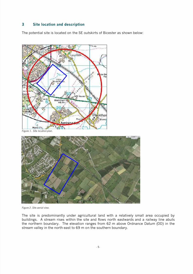
3 Site location and description
The potential site is located on the SE outskirts of Bicester as shown below:
Figure 1. Site location plan.
Figure 2. Site aerial view.
The site is predominantly under agricultural land with a relatively small area occupied bybuildings. A stream rises within the site and flows north eastwards and a railway line abutsthe northern boundary. The elevation ranges from 62 m above Ordnance Datum (OD) in the
stream valley in the north-east to 69 m on the southern boundary.
8/3/2019 Relatório RISCO_CEMITÉRIO
http://slidepdf.com/reader/full/relatorio-riscocemiterio 40/96
- 6-
4 Site geology and hydrogeology
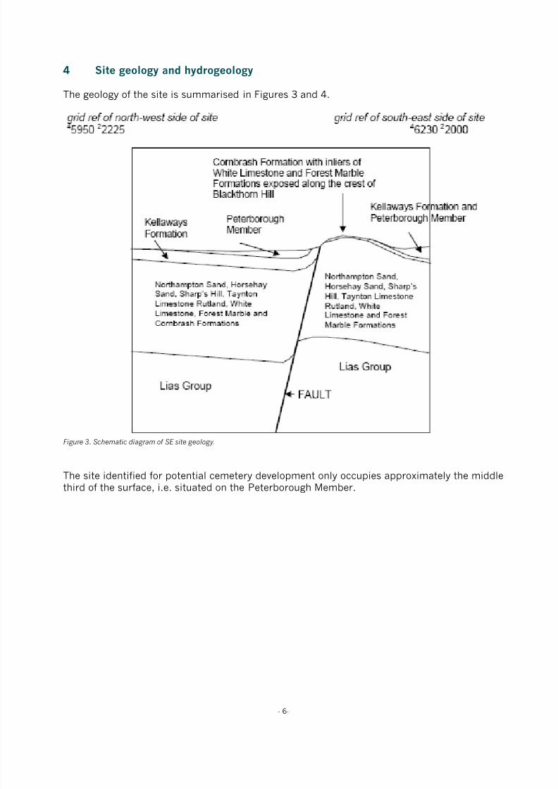
The geology of the site is summarised in Figures 3 and 4.
Figure 3. Schematic diagram of SE site geology.
The site identified for potential cemetery development only occupies approximately the middlethird of the surface, i.e. situated on the Peterborough Member.
8/3/2019 Relatório RISCO_CEMITÉRIO
http://slidepdf.com/reader/full/relatorio-riscocemiterio 41/96
- 7-
4.1 Superficial Deposits (Drift)
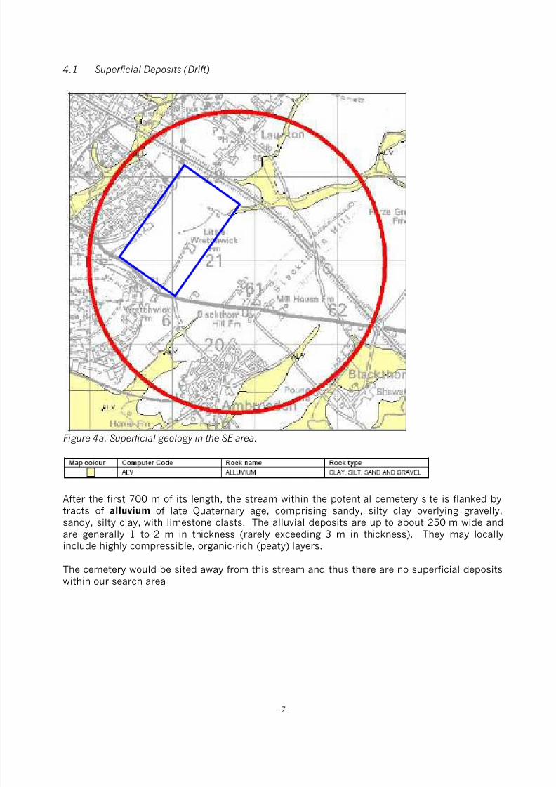
Figure 4a. Superficial geology in the SE area.
After the first 700 m of its length, the stream within the potential cemetery site is flanked bytracts of alluvium of late Quaternary age, comprising sandy, silty clay overlying gravelly,
sandy, silty clay, with limestone clasts. The alluvial deposits are up to about 250 m wide andare generally 1 to 2 m in thickness (rarely exceeding 3 m in thickness). They may locallyinclude highly compressible, organic-rich (peaty) layers.
The cemetery would be sited away from this stream and thus there are no superficial depositswithin our search area
8/3/2019 Relatório RISCO_CEMITÉRIO
http://slidepdf.com/reader/full/relatorio-riscocemiterio 42/96
- 8-
4.2 Rockhead Depth
Rockhead is close to the surface.
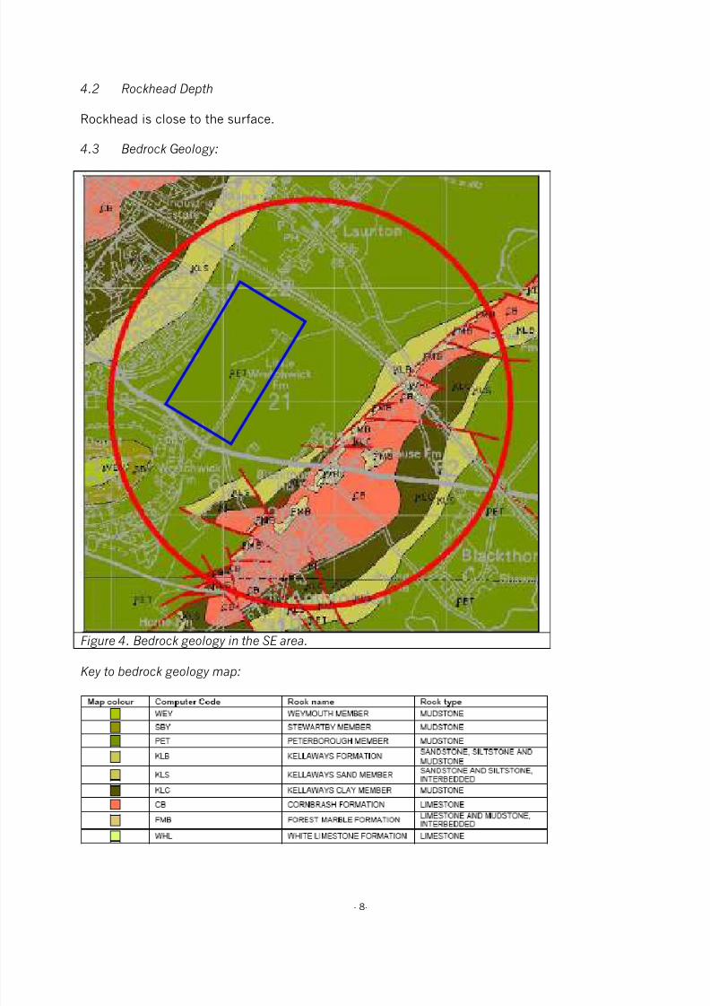
4.3 Bedrock Geology:
Figure 4. Bedrock geology in the SE area.
Key to bedrock geology map:
8/3/2019 Relatório RISCO_CEMITÉRIO
http://slidepdf.com/reader/full/relatorio-riscocemiterio 43/96
- 9-
The search area is underlain at rockhead by various formations and members of the GreatOolite Group, of Mid-Jurassic age, which are dominated by limestones with subordinatemudstone beds, and the Ancholme Group, of Mid- to Late-Jurassic age which are dominatedby mudstones.
The oldest formation at outcrop is the White Limestone Formation, forming two small inliers inthe centre of the Charlton Anticline (Blackthorn Hill area) in the south (see additionalgeological considerations below), and comprising 10 to 12 m of white to yellow, bedded,peloidal and bioclastic limestone. Thin calcareous mudstone beds are present in the basalpart and dark, carbonaceous mudstones predominate over limestone in the upper part.
The White Limestone Formation is overlain with an erosive contact by the Forest MarbleFormation. The Forest Marble Formation forms narrow outcrops between the White LimestoneFormation and the Cornbrash Formation, in places faulted, and forms several inliers in thecentre of the Charlton Anticline in the south. The formation is composed of 3 to 5 m of greycalcareous mudstone with lenticular beds of bioclastic, ooidal limestone, particularly common
at the base.
The Cornbrash Formation forms a broad faulted inlier along the crest of the Charlton Anticline,in part forming Blackthorn Hill. It comprises 2 to 3 m of grey to brown, bioclastic, shelly,rubbly-bedded limestone, with thin subordinate beds of grey mudstone. The limestone-dominated Cornbrash Formation may be affected by dissolution leading to the widening ofjoints and the formation of linear vertical voids, which are likely to fill with rubble and soil.
The Cornbrash Formation is overlain by the Kellaways Formation of Mid-Jurassic age. Overmuch of the outcrop it is divided into a lower Kellaways Clay Member, comprising 1 to 3 m ofdark grey mudstone and an upper Kellaways Sand Member, comprising 3 to 5 m of grey, silty,fine sand or sandstone and siltstone. The formation forms narrow outcrops flanking theCharlton Anticline and also crops out in the north-west. The Kellaways Clay Member hasmoderate shrink-swell susceptibility.
The Oxford Clay Formation is the youngest bedrock unit within the site area, and is fullysubdivided on the map extracts into its three constituent members: in ascending order, thePeterborough, Stewartby and Weymouth Members. All comprise grey fossiliferous mudstone – the Peterborough Member mudstones are dark brownish-grey and high in organic content,totalling about 26 m in thickness; those of the Stewartby and Weymouth Members are palergrey and more calcareous. The Stewartby Member is about 21 m thick, only the lowest fewmetres of the Weymouth Member are present here. The Oxford Clay has moderate to highshrink-swell susceptibility. The mudstone-dominated Kellaways Clay Member and the Oxford
Clay Formation may be unstable on steep slopes or in excavations.
Additional geological considerations:
The White Limestone Formation is underlain by four further formations of the Great OoliteGroup, in ascending order: the Horsehay Sand, the mudstone-dominated Sharp’s Hill, theTaynton Limestone and the mudstone-dominated Rutland formations, totalling about 18 m inthickness.
These are underlain by about 2 m of the ferruginous sandstones of the Northampton SandFormation. Beneath these are over 80 m of the mudstone-dominated Lias Group. Across the
north-western two-thirds of the site area, and in the extreme south-east, the bedrock strata dipvery gently (less than 1°) to the south-east. However, in the south-east lies the northeast -

8/3/2019 Relatório RISCO_CEMITÉRIO
http://slidepdf.com/reader/full/relatorio-riscocemiterio 44/96
- 10-
south-west trending Charlton Anticline – an upfold bringing older rocks to the surface. Thestructure is asymmetrical, with steeper dips up to 6° on the north-west flank and of up to 3° onthe south-east. Faults have been mapped along and cutting across the structure, withdisplacements of up to about 5 m. It is important to understand the nature of geologicalfaults, and the uncertainties which attend their mapped position at the surface. Faults are
planes of movement along which adjacent blocks of rock strata have moved relative to eachother.
They commonly consist of zones, perhaps up to several tens of metres wide, containingseveral to many fractures. The portrayal of such faults as a single line on the geological mapis therefore a generalisation. Geological faults in this area are of ancient origin, are todaymainly inactive, and are thought to present no threat to property.

8/3/2019 Relatório RISCO_CEMITÉRIO
http://slidepdf.com/reader/full/relatorio-riscocemiterio 45/96
- 11-
4.4 Hydrogeology:
There is one small patch of alluvium, and possibly head, within the site area in the floor andflank of one of the valleys. These deposits are of variable permeability. Groundwater may bepresent in hydraulic continuity with the rivers, perched on the impermeable Peterborough
Member bedrock. If the bedrock is permeable, this water may be in hydraulic continuity withunderlying formations.
The whole of the site area is underlain by the Oxford Clay Formation which is generallyregarded as an aquiclude and does not generally yield usable quantities of water. Smallquantities of water may be encountered where weathered or fractured.
The Kellaways Formation often contains very limited quantities of groundwater in the upper,sandier horizon, the Kellaways Sand Member.
The Great Oolite Group limestones transmit water via fractures that can be enhanced by
dissolution; water movement through them can therefore be rapid.
The Cornbrash Formation is a local aquifer and water strikes have been recorded in boreholesdrilled within the site area.
The Forest Marble Formation, where present beneath the area, may hold small quantities ofwater in any limestone bands present, but it generally acts as an aquiclude between theCornbrash and the underlying White Limestone Formation. There are no boreholes drilledthrough the Forest Marble Formation in the site area that record water strikes within it.
The White Limestone Formation constitutes a major aquifer in the area, with some sources ofpublic supply.
A borehole drilled at Graven Hill, (SP52/49 at SP 5920 2048) was drilled through 44.5 m ofthe Oxford Clay Formation and Kellaways Formation combined, 5.1 m of Cornbrash Formation,25.3 m of the Great Oolite Group and terminated in the Upper Lias at 88.4 m. It recordedwater strikes at 20.7 m below ground level in the Oxford Clay Formation, 43 m below groundlevel in the Kellaways Formation and at 50 m and 53.3 m below ground level in the GreatOolite Group.
The uppermost strike was cased out and the rest water level was 27.4 m below ground level(about 63 m above OD); it yielded 7.6 l/s.
There are insufficient data to determine a groundwater flow direction, but locally it willprobably be towards the nearest stream and regionally, down-dip towards the south-east.
The Oxford Clay Formation beneath the site is classified as Non Aquifer on the EnvironmentAgency's Groundwater Vulnerability map, Sheet 30, Northern Cotswolds. However, somegroundwater flow through these rocks may occur and should be considered when assessingthe risk associated with persistent pollutants. The overlying alluvium and underlyingCornbrash and Forest Marble Formations are Minor Aquifers.

8/3/2019 Relatório RISCO_CEMITÉRIO
http://slidepdf.com/reader/full/relatorio-riscocemiterio 46/96
- 12-
5 Boreholes
The plan below shows the location of boreholes relative to the proposed cemeterydevelopment:
Figure 5. Site location, boreholes and watercourses.
The BGS report includes an extensive table referring to these boreholes.

8/3/2019 Relatório RISCO_CEMITÉRIO
http://slidepdf.com/reader/full/relatorio-riscocemiterio 47/96
- 13-
6 Water wells
The plan below shows the location of water wells relative to the proposed cemeterydevelopment:
Figure 6. Site location, water wells.
The BGS report includes an extensive table referring to these water wells.

8/3/2019 Relatório RISCO_CEMITÉRIO
http://slidepdf.com/reader/full/relatorio-riscocemiterio 48/96
- 14-
7 Indicative flood plains
According to the EA’s website, subject to the precise location of any cemetery development,this site lies outside any indicative flood plain (Figure 6).
Figure 6. Environment Agency website flood risk map.

8/3/2019 Relatório RISCO_CEMITÉRIO
http://slidepdf.com/reader/full/relatorio-riscocemiterio 49/96
- 15-
8 Groundwater source protection zones (SPZs)
The Environment Agency (EA) has defined Source Protection Zones (SPZs) for 2000groundwater sources such as wells, boreholes and springs used for public drinking watersupply. These zones show the risk of contamination from any activities that might cause
pollution in the area. The closer the activity, the greater the risk.
Zone 1 (Inner protection zone)
Any pollution that can travel to the borehole within 50 days from any point within the zone isclassified as being inside zone 1. This applies at and below the water table. This zone also hasa minimum 50 metre protection radius around the borehole. These criteria are designed toprotect against the transmission of toxic chemicals and water-borne disease.
Zone 2 (Outer protection zone)
The outer zone covers pollution that takes up to 400 days to travel to the borehole, or 25% ofthe total catchment area – whichever area is the biggest. This travel time is the minimum
amount of time that we think pollutants need to be diluted, reduced in strength or delayed bythe time they reach the borehole.
Zone 3 (Total catchment)
The total catchment is the total area needed to support removal of water from the borehole,and to support any discharge from the borehole.
According to the EA’s website, the Bicester area lies outside Zone 3 (Figures 7a & 7b):
Figure 7a. Ground Water Source Protection ZonesKey: Purple = Total catchment, Green = Outer Zone, Red = Inner
Zone. Taken from Environment Agency website SPZ map.
Figure 7b. Ground Water Source Protection ZonesTaken from Environment Agency website SPZ map.

8/3/2019 Relatório RISCO_CEMITÉRIO
http://slidepdf.com/reader/full/relatorio-riscocemiterio 50/96
- 16-
9 Risk assessment
9.1 Site Vulnerability Assessment
Pertinent criteria, associated comment and assigned score are presented in Tables 4 and 5.
Table 4. Site vulnerability criteria and comment Criteria Comment
Drift Type Absent
Drift Thickness N/A
Depth to Water Table Oxford Clay is an aquicludes
Flow Mechanism Intergranular
Aquifer Non-aquifer
Abstraction and SPZ Outside SPZ 3
Watercourses and springs >100 (subject to precise location within the identified area
Drains None known to be present
Table 5. Site vulnerability assessment score sheet
Factor Site Characteristics Ranking Score
Drift type Absent Very High 10 - 9
Drift thickness N/A Very High 10 - 9
Depth to water table >25m Very Low 2 - 1
Flow mechanism Fracture Flow Very Low 2 - 1
Aquifer Minor aquifer Very Low 2 - 1
Abstraction and Source Protection Zone Outside SPZ 3 Very Low 2 - 1
Watercourses and springs >100m Very Low 2 - 1
Land Drains None known to be present Very Low 2 - 1
Total (range) 32 - 24
Vulnerability Range Actual
Low vulnerability 8 – 32 32 - 24
Moderate vulnerability 32 – 56
High Vulnerability 56 – 80
9.2 Vulnerability Class
Based upon the total ranking score indicated, the site may be classified with a vulnerabilityclass of:
Low: X Moderate: High:
9.3 Scale of Development
The anticipated number of annual full earth burials, as opposed to cremated remains, is 50.

8/3/2019 Relatório RISCO_CEMITÉRIO
http://slidepdf.com/reader/full/relatorio-riscocemiterio 51/96
- 17-
9.4 Level of Risk
The EA level of risk to the number of anticipated burial rates and groundwater vulnerabilityusing a nomograph reproduced in Figure 8.
Figure 8. Schematic relationship between burial rates, vulnerability class and level of risk (from EA R & D Technical Report P223(1999).
With reference to Figure 8, the level of risk at this site is considered to be ‘Moderate’.
50 bodies per year

8/3/2019 Relatório RISCO_CEMITÉRIO
http://slidepdf.com/reader/full/relatorio-riscocemiterio 52/96
- 18-
10 Discussion and conclusions
The vulnerability ranking assigned to this site is ‘Low’, and the numbers of anticipated annualburials gives a Risk rating of ‘Moderate’.
The site characteristic that raised the vulnerability score was:
• Absence of superficial deposits
Applied Geotechnical Engineering excavated a number of trial pits around the Bicester ringroad during June 2006. Trial pit 12 was located near the proposed site and revealed firm tostiff clay to 1.4 m changing to soft, shaley clay to 2.2 m.
There was some evidence of water seepage into the trial pit at its base.
The Oxford Clay is an aquiclude, i.e. it has low hydraulic conductivity, preventing the
movement of groundwater. The BGS report indicates that small quantities of groundwatermay be found where the Oxford Clay is weathered or fractured.
A land drain was found within the trial pit at 0.8 m. Further investigation would be required toestablish the presence and efficacy of land drains on any specific site within this areaproposed for a cemetery development.
Subject to appropriate site investigations and agreement with the EA, it may be possible toeither adjust the risk rating of the site or to design measures, such as drainage orspecifications for burials, to mitigate any risk to groundwaters.
8/3/2019 Relatório RISCO_CEMITÉRIO
http://slidepdf.com/reader/full/relatorio-riscocemiterio 53/96
- 19-
11 Recommendations
It is recommended that this report and the accompanying BGS report be circulated to the EAand dialogue should be established with the EA to ascertain their requirements for furtherassessment of this site’s suitability for development as a cemetery.
Subject to the outcome of this dialogue, if detailed site investigations were thought desirable,it is proposed that the site investigation should consist of the following:
1. A topographic survey to provide a basis for designing the cemetery and any necessarydrainage infrastructure.
2. An electro-magnetic induction (EMI) survey to provide a basis for establishing the mostappropriate locations for excavating soil profile pits down to a maximum depth of 3.5 mand installing a minimum of three dip wells (up to 10 m deep) to monitor ground waterdepth. The EMI data would be shown on the site plan to two different depths (200 mm
and 1.2 m).
3. Assessment of the soil profile pits, and to ‘window sample’ material removed during theboring of the dip wells, in terms of the type, condition and physical properties of thesoil exposed. The results will be used to determine factors that may influence theappropriateness of the site for burial purposes and the vulnerability of the environmentto contamination from the proposed development.
4. Monitor the groundwater levels in the dip wells over a winter period, i.e. during theperiod of highest rainfall.
5. Determine any appropriate options for mitigating risk to ground and surface water byimproving the surface and subsurface drainage status.
Depending upon the results of this sampling and analysis, it may be possible to use the site asa cemetery subject to certain restrictions such as the installation of an appropriate drainagescheme.

8/3/2019 Relatório RISCO_CEMITÉRIO
http://slidepdf.com/reader/full/relatorio-riscocemiterio 54/96
- 20-
Confidentiality
This presentation is confidential and is only for the use of officers of Bicester Town Counciland Cherwell District Council (or their representatives). Without the specific consent in writingof TurfTrax Ground Management Systems Limited, no copies of this presentation are to be
made and information contained herein should not be communicated to any third party. Atthe request of TurfTrax Ground Management Systems Limited all copies of this document, inwhatever form, are to be returned.
12 Contact details
Commercial OfficeChequers Court31 Brown StreetSalisburyWiltshire
SP1 2AS
Tel: 01722 434000Fax: 01722 434040
Technical OfficeUnit 1, Highfield ParcHighfield RoadOakleyBedfordshire
MK43 7TA
Tel: 01234 821750Fax: 01234 821751Email: [email protected]

8/3/2019 Relatório RISCO_CEMITÉRIO
http://slidepdf.com/reader/full/relatorio-riscocemiterio 55/96
- 21-
13 Appendices

8/3/2019 Relatório RISCO_CEMITÉRIO
http://slidepdf.com/reader/full/relatorio-riscocemiterio 56/96
- 49-
Publications by key staff
A guide to better soil structure. Booklet based on MAFF funded project SP0305 “A national soilvulnerability-based framework for the provision of farm-specific guidance on the management of soilstructure”. National Soil Resources Institute, Cranfield University, Silsoe, Bedfordshire, MK45 4DT,September 2001.
Alexandrou, A. & Earl, R. (1998). The relationship between the pre-compaction stress, volumetricwater content and initial dry bulk density of soil. Journal of Agricultural Engineering Research 71, 75-80.
Alexandrou, A & Earl, R. (1997). Development of a technique for assessment the behaviour of soilunder load. Journal of Agricultural Engineering Research 68, 169- 180.
Alexandrou, A. & Earl, R. (1995). In situ determination of the pre-compaction stress of a soil. Journalof Agricultural Engineering Research 61, 67-72.
Bulson, H.A.J., Welsh, J.P., Stopes, C.E. & Woodward, L. (1996). Agronomic viability and potential
economic performance of three organic four year rotations without livestock, 1988-1995. Aspects ofApplied Biology 47: Rotations and cropping systems, 277-286.
Churcher, D.W., Greenwood, J.R., Vickers, A.W. Morgan, R.P.C., Coppin, N.J. & Norris, J.E. (1999). Abioengineering demonstration trial, Kent, England. In: Proceedings 2nd International Conference onLandslides, Slope Stability and the Safety of Infrastructures. ISBN 981-04-1537-0.
S.K. Cook, W.F. Cormack, M. Green, J.M. Holland, A.R. Leake and J.P. Welsh. (2000). Farmingsystems for the new Millennium. Aspects of Applied Biology 62. AAB, Wellesbourne, UK.
Davies, D.H.K. & Welsh, J.P. (2002). Weed control in organic cereals and pulses. In: Organic cerealsand pulses (eds) D Younie, BR Taylor, JP Welsh and JM Wilkinson. Chalcombe Publications, Lincoln,
UK. 77-114.
Earl, R. (1998). Tillage - soil, plant and implement considerations. Landwards 53, 17-23.
Earl, R. (1998). Principles of traction and compaction. Landwards 53, 14-16.
Earl, R. (1997). Prediction of trafficability and workability from soil moisture deficit. Soil and TillageResearch 40, 155-168.
Earl, R. (1997). Assessment of the behaviour of field soils during compression. Journal of AgriculturalEngineering Research 68, 147- 158.
Earl, R. (1996). Prediction of trafficability and workability using tensiometers. Journal of AgriculturalEngineering Research 63, 27-34.
Earl, R., Taylor, J.C., Wood, G.A., Bradley, I.T., Waine, T., Welsh, J.P., Godwin, R.J. & Knight, S.M.(2003). Soil factors and their influence on within-field crop variability, Part I: Field observation of soilvariation. Biosystems Engineering 84(4), 425-440.
Earl, R. & Alexandrou, A. (2001). Deformation processes below a plate sinkage test on sandy loam:theoretical approach. Journal of Terramechanics 38, 153-162.
Earl, R. & Alexandrou, A. (2001). Deformation processes below a plate sinkage test on sandy loam:experimental approach. Journal of Terramechanics 38, 163-183.
Earl, R. & Carter, A.D. (1991). The sampling of water in an unsaturated soil. The Agricultural Engineer46, 50-51.

8/3/2019 Relatório RISCO_CEMITÉRIO
http://slidepdf.com/reader/full/relatorio-riscocemiterio 57/96
- 50-
Earl, R. and Wheeler, P.N. Lined moles cut drainage costs. Arable Farming, June 1993, p 27-32.
Earl, R., Wheeler, P.N., Blackmore, B.S. & Godwin, R.J. (1996). Precision farming - the management ofvariability. Landwards 51(4), 18-23.
Godwin, R.J., Richards, T.E., Wood, G.A., Welsh, J.P. & Knight, S.M. (2003). An economic analysis of
the potential for precision farming in UK cereal production. Biosystems Engineering 84(4), 533-545.
Godwin, R.J., Wood, G.A., Taylor, J.C., Knight, S.M. & Welsh, J.P. (2003). Precision farming of cerealcrops: A review of a six year experiment to develop management guidelines. Biosystems Engineering84(4), 375-391.
Greenwood, J.R., Vickers, A.W., Morgan, R.P.C., Coppin, N.J. & Norris, J.E. (2001). Bioengineering: TheLongham Wood Cutting field trial. CIRIA Project report 81. ISBN 0 86017 881 1.
Gregory, A.S., Kendall, B.A., Earl, R. & Vickers, A.W. (2002). The effects of engineering practices andincorporation of amendments on soil structural development in a clay soil-forming material used as alandfill restoration cap. A report for shanks first fund.
Gregory, A.S. & Vickers, A.W. (2004). The effects of amendments on soil structural development in aclay soil-forming material used as a landfill restoration cap. Soil Use and Management.
Kendall, B.A., Gregory, A.S., Earl, R., & Vickers, A.W. (2001). The effects of engineering practices andamendments on soil structural development in a clay landfill restoration cap. In: Eighth InternationalWaste Management and Landfill Symposium. 1st - 5th October 2001. Sardinia, Italy. Proceedings.Volume 4. pp 371-380.
Morgan, R.P.C., Mcintyre, K., Vickers., A.W.V., Quinton, J.N. & Rickson, R.J. (1997). A rainfallsimulation study of soil erosion on rangeland in Swaziland. Soil Technology 11, 291-299.
Pearce, B.D., Wolfe, M.S. & Welsh, J.P. (2002). Review of knowledge of the potential impacts ofgenetically modified organisms (GMO) on organic agriculture. In: Proceedings of the 14th IFOAM WorldCongress, Canada.
Philipps, L., Welsh, J.P., Bulson, H.A.J. & Woodward, W. (1999). Agronomic viability and potentialeconomic performance of three organic four year rotations without livestock, 1988-1998. Proceedingsof the 12th IFOAM Conference - Organic Agriculture: Credible Solutions for the 21st Century, Argentina.109-115.
J Powell, G Davies, S Fowler, M Hovi, N Lampkin, M Lennartsson, S Padel, B Pearce, L Philipps, JRobertson, E Stockdale, C Watson, R Weller, J Welsh and M Wolfe. (2002). Proceedings of the UKOrganic Research 2002 Conference. Organic Centre Wales, Aberystwyth, UK.
Reeve, M.J. and Earl, R. (1990). The effect of soil strength on agricultural and civil engineering fieldoperations. Soil Survey Report, MAFF Contract 3806.
Schmidt, H., Philipps, L., Welsh, J.P. & Fragstein, P.V. (1999). Legume breaks in stockless organicfarming rotations: Nitrogen accumulation and influence on the following crops. Biological Agricultureand Horticulture 17, 159-170.
Spoor, G., Earl, R. and Wheeler, P.N. (1992). Development of lower cost drainage systems for heavysoils. HGCA Project Report No 64.
Spoor, G, Hann, M J, Godwin, R J, Leeds-Harrison, P B, Miller, S M. (1987). Machinery Developmentsfor Reducing Draught and Improving the Grading Characteristics of Mole Ploughs. ASAE 5th National
Drainage Symposium.
8/3/2019 Relatório RISCO_CEMITÉRIO
http://slidepdf.com/reader/full/relatorio-riscocemiterio 58/96
- 51-
Taylor, J.C., Wood, G.A., Earl, R. & Godwin R.J. (2003). Soil factors and their influence on within-fieldcrop variability, Part II: Spatial analysis and determination of management zones. BiosystemsEngineering 84(4), 441-453.
Taylor, J.C., Wood, G.A., Welsh, J.P. & Knight S. (2000). Exploring management strategies forprecision farming of cereals assisted by remote sensing. Aspects of Applied Biology 60: Remote
Sensing in Agriculture, 53-60.
Thomasson, A.J., Carter, A.D., Jones, R.J.A., Leverton, R.E., Earl, R., Bouma, J., Van Wijk, A.L.M.,Feddes, R.A., Van Lanen, H.A.J., Kabat, P. And Hack-ten Broeke, M.J.D. (1989). Use of modernphysical field methods and computer simulation for land evaluation purposes. Report to EC DG VI,Research Contract No 5711.
Toyne, K. & Vickers, A.W. (2003). Critical evaluation of the ASTM method of measuring percolationrates of rootzones materials. Paper presented at National Turfgrass Foundation National Conference,Southport. November 2003.
Vickers, A.W. & James, I.T. (2003). Management of cracking in clay soils used for cricket pitches.
Paper presented at the Institute of Groundsmanship Annual Conference, Leicester, April 2003.
Vickers, A.W. (2002). Experimental Design for evaluation of products for sportsturf. Paper presented atNational Turfgrass Foundation National Conference, Southport. November 2002.
Vickers, A.W. (2001). Optimisation of rolling on cricket pitches. Paper presented at the 2001 Institute ofGroundsmanship Annual Conference, Haydock.
Vickers, A.W. (2001). Soil water management for sports surfaces. Paper presented at the 2001Institute of Groundsmanship Annual Conference, Haydock.
Vickers, A.W. & Morgan, R.P.C. (1999). Soil water monitoring to assess the effectiveness of three
bioengineering treatments on an unstable Gault Clay cutting in Southern England. In: Proceedings 2ndInternational Conference on Landslides, Slope Stability and the Safety of Infrastructures. ISBN 981-04-1537-0
Vickers, A.W. (1994). A simple field erodibility index based on some English soils. In: Conserving SoilResources, European Perspectives. Edit. R.J. Rickson. CAB International. pp 70 - 78.
Welsh, J.P., Philipps, L. & Cormack, W.F. (2002). The long-term agronomic performance of organicstockless rotations. In: Proceedings of the UK Organic Research 2002 Conference. Organic CentreWales, Aberystwyth, UK. 47-50.
Welsh, J.P., Wolfe, M.S. & Pearce, B.D. (2002). The performance of cereal varieties under organicsystems in on-farm trials in England. In: Proceedings of the 14th IFOAM World Congress, Canada.
Welsh, J.P., Wolfe, M.S., Snape, J. & Pearce, B.D. (2002). Generating and evaluating a novel geneticresource in wheat in diverse environments. In: Proceedings of the 14th IFOAM World Congress, Canada.311.
Welsh, J.P. & Wolfe, M.S. (2002). The performance of variety mixtures and the potential for populationbreeding in organic farming systems. Proceedings of the ECO-PB Symposium: Organic seed production& plant Breeding – strategies, problems and perspectives, Berlin.
Welsh, J.P., Wood, G.A., Godwin, R.J., Taylor, J.C., Earl, R., Blackmore, S. & Knight, S.M. (2003).Developing strategies for spatially variable nitrogen application in cereals, Part I: Winter barley.Biosystems Engineering 84(4), 481-494.

8/3/2019 Relatório RISCO_CEMITÉRIO
http://slidepdf.com/reader/full/relatorio-riscocemiterio 59/96
- 52-
Welsh, J.P., Wood, G.A., Godwin, R.J., Taylor, J.C., Earl, R., Blackmore, S. & Knight, S.M. (2003).Developing strategies for spatially variable nitrogen application in cereals, Part II: Wheat. BiosystemsEngineering 84(4), 495-511.
Welsh, J.P., Bulson, H.A.J., Stopes, C.E., Froud-Williams, R.J. & Murdoch, A.J. (1999). The criticalweed-free period in organically-grown winter wheat. Annals of Applied Biology 134, 315-320.
Welsh JP, Bulson H A J, Philipps L and Wolfe M. (1999). Weed control strategies for organic cerealcrops. Proceedings of the 1999 Brighton Crop Protection Conference – Weeds. 945-950.
Welsh JP, Bulson H A J, Stopes C E, Froud-Williams R J and Murdoch A J. (1997). Mechanical weedcontrol in organic winter wheat. Aspects of Applied Biology 50: Optimising Cereal Inputs - Its ScientificBasis. 375-384.
Welsh JP, Bulson H A J, Stopes C E, Murdoch A J and Froud-Williams R J. (1997). The critical periodof weed competition and its application in organic winter wheat. Proceedings of the 1997 Brighton CropProtection Conference - Weeds. 105-110.
Welsh JP, Bulson H A J, Stopes C E, Froud-Williams R J and Murdoch A J. (1996). Weed control inorganic winter wheat using a spring-tine weeder. Proceedings of the Second International Weed ControlCongress, Copenhagen. 1127-1132
Wood, G.A., Welsh, J.P., Godwin, R.J., Taylor, J.C., Earl, R. & Knight, S.M. (2003). Real-time measuresof canopy size as a basis for spatially varying nitrogen applications to winter wheat sown at differentseed rates. Biosystems Engineering 84(4), 513-531.
D. Younie, B.R. Taylor, J.P. Welsh & J.M. Wilkinson. (2002). Organic Cereals and Pulses. ChalcombePublications, Lincoln, UK.
Zimbone, S.M., Vickers, A.W., Morgan, R.P.C. & Vella, P. (1996). Field investigations of different
techniques for measuring soil surface shear strength. Soil Technology. 9. pp 101 – 111.

8/3/2019 Relatório RISCO_CEMITÉRIO
http://slidepdf.com/reader/full/relatorio-riscocemiterio 60/96
- 53 -
Turftrax Ground Management Systems Limited
Terms and Conditions for the Supply of Services
Interpretation
In these Conditions
AGREED FEE means the charges agreed between TurfTrax and the Client in relation to
the Specified Service
CLIENT means the person named on the Specification Sheet for whom TurfTrax has
agreed to provide the Specified Service in accordance with these Conditions
CONTRACT means the contract for the provision of the Specified Service
DOCUMENT includes, in addition to a document in writing, any map, plan, graph,
drawing or photograph, any film, negative, tape or other device embodying visual images
and any disc, tape or other device embodying any other dataINPUT MATERIAL means any Documents or other materials, and any data or other
information provided by the Client relating to the Specified Service
OUTPUT MATERIAL means any Documents or other materials, and any data or other
information provided by TurfTrax relating to the Specified Service
SPECIFICATION SHEET means the sheet to which these Conditions are appended
SPECIFIED SERVICE means the service relating to geophysical surveys of land to be
provided by TurfTrax for the Client and referred to in the Specification Sheet
TURFTRAX means TurfTrax Ground Management Systems Limited (registered in
England under number 4135392 ) or its subsidiary as stated on the Specification Sheet
The headings in these Conditions are for convenience only and shall not affect their
interpretation.
Supply of the Specified Service
TurfTrax shall provide the Specified Service to the Client subject to these Conditions.
Any changes or additions to the Specified Service or these Conditions must be agreed in
writing by TurfTrax and the Client.
The Client shall allow TurfTrax adequate access to its property at reasonable times and
for so long as is necessary to enable TurfTrax to provide the Specified Service in
accordance with the Contract.
The Client shall at its own expense supply TurfTrax with all necessary Documents orother materials, and all necessary data or other information relating to the Specified
Service, within sufficient time to enable TurfTrax to provide the Specified Service in
accordance with the Contract. The Client shall ensure the accuracy of all Input Material.
TurfTrax shall have no liability for any loss or damage, however caused, to the Input
Material. All Output Material shall be at the sole risk of the Client from the time of
delivery to or to the order of the Client.
The Specified Service shall be provided in accordance with the Specification Sheet
subject to these Conditions.
Further details about the Specified Service, and advice or recommendations about its
provision or utilisation, which are not given in TurfTrax’s brochure or other promotional
literature, may be made available on written request.
TurfTrax may correct any typographical or other errors or omissions in any brochure,
promotional literature, quotation or other document relating to the provision of the
Specified Service without any liability to the Client.
TurfTrax may at any time without notifying the Client make any changes to the Specified
Service which are necessary to comply with any applicable safety or other statutory
requirements, or which do not materially affect the nature or quality of the Specified
Service.Charges
Subject to any special terms agreed, the Client shall pay the Agreed Fee and any
additional sums which are agreed between TurfTrax and the Client for the provision of
the Specified Service or which, in TurfTrax’s sole discretion, are reasonably incurred as a
result of the Client’s instructions or lack of instructions, the inaccuracy of any Input
Material or any other cause attributable to the Client.
All charges quoted to the Client for the provision of the Specified Service are exclusive of
any Value Added Tax, for which the Client shall be additionally liable at the applicable
rate from time to time.
TurfTrax shall be entitled to invoice the Client on completion of the Specified Service.
The Agreed Fee and any additional sums payable shall be paid by the Client (together
with any applicable Value Added Tax, and without any set-off or other deduction) within
30 days of the date of TurfTrax’s invoice.
If payment is not made on the due date, TurfTrax shall be entitled, without limiting any
other rights it may have, to charge interest on the outstanding amount (both before and
after any judgment) at the rate of 4 % above the base rate from time to time of Barclays
Bank plc from the due date until the outstanding amount is paid in full.
Rights in Input Material and Output Material
The property and any copyright or other intellectual property rights in:any Input Material shall belong to the Client
any Output Material and any amendments or variations to the Input Material made by
TurfTrax shall, unless otherwise agreed in writing between the Client and TurfTrax,
belong to TurfTrax, subject only to the right of the Client to use the Output Material for
the purposes of utilising the Specified Service.
Any Input Material or other information provided by the Client which is so designated by
the Client and any Output Material shall be kept confidential by TurfTrax, and all Output
Material or other information provided by TurfTrax which is so designated by TurfTrax
shall be kept confidential by the Client; but the foregoing shall not apply to any
Documents or other materials, data or other information which are public knowledge at
the time when they are so provided by either party, and shall cease to apply if at any
future time they become public knowledge through no fault of the other party.
The Client warrants that any Input Material and its use by TurfTrax for the purpose of
providing the Specified Service will not infringe the copyright or other rights of any third
party, and the Client shall indemnify TurfTrax against any loss, damages, costs, expenses
or other claims arising from any such infringement.
Warranties and Liability
TurfTrax warrants to the Client that the Specified Service will be provided usingreasonable care and skill and, as far as reasonably possible, in accordance with the
Specification and at the intervals and within the times referred to in the Specification
Sheet. Where TurfTrax supplies in connection with the provision of the Specified Service
any goods (including Output Material) supplied by a third party, TurfTrax does not give
any warranty, guarantee or other term as to their quality, fitness for purpose or otherwise,
but shall, where possible, assign to the Client the benefit of any warranty, guarantee or
indemnity given by the person supplying the goods to TurfTrax.
TurfTrax shall have no liability to the Client for any loss, damage, costs, expenses or
other claims for compensation arising from any Input Material or instructions supplied by
the Client which are incomplete, incorrect, inaccurate, illegible, out of sequence or in the
wrong form, or arising from their late arrival or non-arrival, or any other fault of the
Client.
Except in respect of death or personal injury caused by TurfTrax’s negligence, or as
expressly provided in these Conditions, TurfTrax shall not be liable to the Client by
reason of any representation (unless fraudulent), or any implied warranty, condition orother term, or any duty at common law, or under the express terms of the Contract, for
any loss of profit or any indirect, special or consequential loss, damage, costs, expenses or
other claims (whether caused by the negligence of TurfTrax, its servants or agents or
otherwise) which arise out of or in connection with the provision of the Specified Service
or their use by the Client, and the entire liability of TurfTrax under or in connection with
the Contract shall not exceed the amount of TurfTrax’s charges for the provision of the
Specified Service, except as expressly provided in these Conditions.
TurfTrax shall not be liable to the Client or be deemed to be in breach of the Contract by
reason of any delay in performing, or any failure to perform, any of TurfTrax’s
obligations in relation to the Specified Service, if the delay or failure was due to any
cause beyond TurfTrax’s reasonable control.
Termination
Either party may (without limiting any other remedy) at any time terminate the Contract
by giving written notice to the other if the other commits any breach of these Conditions
and (if capable of remedy) fails to remedy the breach within 30 days after being required
by written notice to do so.
Insolvency of Client
This clause applies if:
the Client makes any voluntary arrangement with its creditors or (being an individual orfirm) becomes bankrupt or (being a company) becomes subject to an administration order
or goes into liquidation (otherwise than for the purposes of amalgamation or
reconstruction); or
an encumbrance takes possession, or a receiver is appointed, of any of the property or
assets of the Client; or
the Client ceases, or threatens to cease, to carry on business; or
TurfTrax reasonably apprehends that any of the events mentioned above is about to occur
in relation to the Client and notifies the Client accordingly. If this clause applies then, without prejudice to any other right or remedy available to
TurfTrax, TurfTrax shall be entitled to cancel the Contract or suspend any further
provision of services under the Contract without any liability to the Client, and if the
Services have been provided but not paid for the price shall become immediately due and
payable notwithstanding any previous agreement or arrangement to the contrary.
General
These Conditions (together with the terms, if any, set out in the Specification Sheet)
constitute the entire agreement between the parties, supersede any previous agreement or
understanding and may not be varied except in writing between the parties. All other
terms and conditions, express or implied by statute or otherwise, are excluded to thefullest extent permitted by law.
Any notice required or permitted to be given by either party to the other under these
Conditions shall be in writing addressed to the other party at its registered office or
principal place of business or such other address as may at the relevant time have been
notified pursuant to this provision to the party giving the notice.
No failure or delay by either party in exercising any of its rights under the Contract shall
be deemed to be a waiver of that right, and no waiver by either party of any breach of the
Contract by the other shall be considered as a waiver of any subsequent breach of the
same or any other provision.
If any provision of these Conditions is held by any competent authority to be invalid or
unenforceable in whole or in part, the validity of the other provisions of these Conditions
and the remainder of the provision in question shall not be affected.
Any dispute arising under or in connection with these Conditions or the provision of the
Specified Service shall be referred to arbitration by a single arbitrator appointed by
agreement or (in default) nominated on the application of either party by the President for
the time being of Institute of Arbitrators.
English law shall apply to the Contract, and the parties agree to submit to the
non-exclusive jurisdiction of the English courts.
Author: Peter MitchellDr Richard Earl
Released by: Dr James Welsh
Signed:
Date: 6th March 2008
Standard Terms and Conditions
8/3/2019 Relatório RISCO_CEMITÉRIO
http://slidepdf.com/reader/full/relatorio-riscocemiterio 61/96
A report to Bicester Town Council on a Tier 1 hydrological riskassessment of land identified for development as a newcemetery to the SW of Bicester.
16th July 2008
Director: Dr. R EarlTGMS LimitedRegistered Office: Borneo Linnells SolicitorsDixon House 77-97 Harpur Street Bedford MK40 2SYCompany Registration Number: 06623973

8/3/2019 Relatório RISCO_CEMITÉRIO
http://slidepdf.com/reader/full/relatorio-riscocemiterio 62/96
Bicester Town Council
A report on a Tier 1 hydrological risk assessment of land
identified for development as a new cemetery to the SWof Bicester
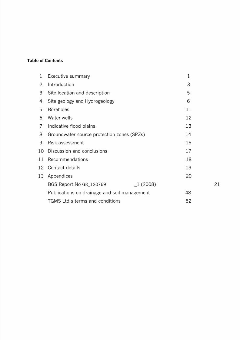
8/3/2019 Relatório RISCO_CEMITÉRIO
http://slidepdf.com/reader/full/relatorio-riscocemiterio 63/96
Table of Contents
1 Executive summary 1
2 Introduction 3
3 Site location and description 5
4 Site geology and Hydrogeology 6
5 Boreholes 11
6 Water wells 12
7 Indicative flood plains 13
8 Groundwater source protection zones (SPZs) 14
9 Risk assessment 15
10 Discussion and conclusions 17
11 Recommendations 18
12 Contact details 19
13 Appendices 20
BGS Report No GR_120769 _1 (2008) 21
Publications on drainage and soil management 48
TGMS Ltd’s terms and conditions 52

8/3/2019 Relatório RISCO_CEMITÉRIO
http://slidepdf.com/reader/full/relatorio-riscocemiterio 64/96
- 1-
1 Executive summary
Peter Mitchell Associates, on behalf of TGMS Limited, has completed a Tier 1 hydrological riskassessment of land identified for development as a new cemetery to the SW of Bicester.
This report is an initial assessment of the identified site’s suitability for use as a cemetery. Inorder to study independent data concerning the site, a Detailed Geological Assessment reportwas commissioned from the British Geological Survey (BGS). This Assessment is attached asan appendix to this report and extracts from it have been incorporated into the text below.
The key issues that have been identified are summarised below.
Using the relationship between vulnerability class, burial rates and level of risk, theappropriate level of risk assessment for this site is ‘High’. It is likely that the EnvironmentAgency (EA) would oppose the development of this site as a cemetery without further site-specific investigative work.
The factors leading to a vulnerability ranking of Moderate are:
• Absence of superficial deposits
• Fracture flow groundwater movement mechanism
• Minor aquifers beneath the site
These factors are generalized for the whole site. However, if one only considered the southeastern third of the site for cemetery use, there would be a different assessment. This isbecause the bedrock is Kellaways Clay Member, overlying the Cornbrash Formation.
Any pollution affecting the Cornbrash would flow downwards into the Forest Marble andbeyond, with the potential to affect water quality in aquifers.
However, it is possible that the Kellaways Clay Member consisting of dark grey mudstonewould afford sufficient protection to these underlying strata. This would depend upon thehydrogeological characteristics of this mudstone at this particular site and would only beapplicable if burials were confined to areas of the site where the mudstone were sufficientlythick.
Conclusions
The Vulnerability ranking assigned to the site is ‘Moderate’. However, the score is in the lowerrange and confining burials to the Kellaways Clay Member could reduce the score sufficientlyto bring the site into the “Low” vulnerability ranking. Unfortunately, even if this were so, theEA’s link between vulnerability class, burial rates and level of risk means that the site wouldstill attract a Moderate Risk rating, as it is the conclusion of P223 that more than 10 burialsper year automatically attracts a risk level of “Moderate”.
In order to fully evaluate this site’s potential for use as a cemetery, it is essential to obtaindefinitive data concerning the exact conditions within the Kellaways Clay Member. It will benecessary to liaise with the Environment Agency and agree site-specific investigationprocedures that can provide these data.
8/3/2019 Relatório RISCO_CEMITÉRIO
http://slidepdf.com/reader/full/relatorio-riscocemiterio 65/96
- 2-
Subject to appropriate site investigations and agreement with the EA, it may be possible toeither adjust the risk rating of the site to “Low” or to design measures, such as sub-surfacedrainage, to mitigate any risk to groundwaters.
Recommendations
It is recommended that this report and the accompanying BGS report be circulated to the EAand dialogue should be established with the EA to ascertain their requirements for furtherassessment of the south eastern part of this site’s suitability for development as a cemetery.Subject to the outcome of this dialogue, it is proposed that the site investigation shouldconsist of the following:
1. A topographic survey to provide a basis for designing the cemetery and any necessarydrainage infrastructure.
2.
An electro-magnetic induction (EMI) survey to provide a basis for establishing the mostappropriate locations for excavating soil profile pits down to a maximum depth of 3.5 mand installing three dip wells (up to 10 m deep) to monitor ground water depth. TheEMI data would be shown on the site plan to two different depths (200 mm and 1.2 m).
3. Assessment of the soil profile pits, and to ‘window sample’ material removed during theboring of the dip wells, in terms of the type, condition and physical properties of thesoil exposed. The results will be used to determine factors that may influence theappropriateness of the site for burial purposes and the vulnerability of the environmentto contamination from the proposed development.
4. Monitor the groundwater levels in the dip wells over a winter period, i.e. during theperiod of highest rainfall.
5. Determine any appropriate options for mitigating risk to ground and surface water byimproving the surface and subsurface drainage status.
Depending upon the results of this sampling and analysis, it may be possible to use the site asa cemetery. This may be subject to certain restrictions and the installation of an appropriatedrainage scheme.

8/3/2019 Relatório RISCO_CEMITÉRIO
http://slidepdf.com/reader/full/relatorio-riscocemiterio 66/96
- 3-
2 Introduction
This report is an initial assessment of a broad area of land to the SW of Bicester with respectto its suitability for use as a cemetery.
Whilst definitive data regarding the pollution from cemeteries is scarce, any planningapplication for a new cemetery will be assessed by the local Environment Agency (EA) teamagainst their Research and Development Technical Report P223 published in 1999 entitled‘Pollution Potential of Cemeteries – Draft Guidance’. The approach to risk assessmentadopted by the report can be summarised by the following excerpt:
“in order to be able to provide guidance which will enable Environment Agency staff to adopt aconsistent approach when assessing the risks associated with the development of human or animalburial grounds. The guidance is directed principally at the potential threats to groundwater resources,but account is taken also of possible risks to surface waters, soils and the atmosphere” 1
The report provides a framework for assessing the risks associated with cemeteries. The firststage is a ‘Tier One’ preliminary site assessment that provides an initial review of the potentialpathways for contamination and receptors in proximity to the site.
The P233 report sets out the likely types and quantities of pollutants released by the burial ofhuman bodies. The key to whether a site would be considered suitable is the rate at whichsuch pollutants would be transported through the ground to enter water supplies:
“Pathways which pose the greatest threat to groundwaters from dissolved and particulatecontaminants are those where hydrogeological factors allow rapid movement of pollutants from thesource to the groundwater…
Consequently, coarse granular or heavily fractured sub-soils, fissured aquifer materials, or those of restricted mineralogy, are unlikely to offer significant opportunities for attenuation by many of theprocesses…By contrast, aquifers composed of sediments or rocks of mixed mineralogy and in whichgroundwater flows are irregular, provide more effective protection of groundwater from surfacederived pollution.”2
The EA’s Technical Report P223 identifies that the number of burials in a proposed cemeterywill affect the overall assessment of the environmental risk. Thus a site considered low risk interms of groundwater vulnerability, automatically becomes a high risk proposal if more than100 burials are anticipated each year. This relationship between vulnerability class, burial
rates and level of risk is shown schematically in Figure 5.2 of P223, featured later in thisreport.
1 P223 page 12 P223 page 30
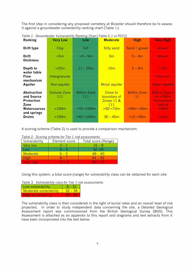
8/3/2019 Relatório RISCO_CEMITÉRIO
http://slidepdf.com/reader/full/relatorio-riscocemiterio 67/96
- 4-
The first step in considering any proposed cemetery at Bicester should therefore be to assessit against a groundwater vulnerability ranking chart (Table 1):
Table 1. Groundwater Vulnerability Ranking Chart (Table 5.1 in P223)
Ranking Very Low Low Moderate High Very High
Drift type Clay Silt Silty sand Sand / gravel Absent
Driftthickness
>5m >3 – 5m 3m 0 – 3m Absent
Depth towater table
>25m 11 – 25m 10m 5 – 9m < 5m
Flowmechanism
Intergranular Fissured
Aquifer Non-aquifer Minor aquifer Major aquifer
Abstractionand SourceProtectionZone
Outside Zone111
Within Zone111
Close toboundary ofZones 11 &
111
Within Zone11
Within Zone 1or <250m
from privatesource
Watercoursesand springs
>100m >70 <100m >50 <70m >30m <50m <30m
Drains >100m >40 <100m 30 – 40m >10 <30m <10m
A scoring scheme (Table 2) is used to provide a comparison mechanism:
Table 2. Scoring scheme for Tier 1 risk assessments
Vulnerability Element score Total score (Range)
Very low 2 – 1 16 – 8
Low 4 – 3 32 -24
Moderate 6 – 5 48 – 40
High 8 – 7 64 – 56
Very high 10 – 9 80 – 72
Using this system, a total score (range) for vulnerability class can be obtained for each site:
Table 3. Vulnerability class for Tier 1 risk assessments
Low vulnerability 8 – 32
Moderate vulnerability 32 – 56
High Vulnerability 56 – 80
The vulnerability class is then considered in the light of burial rates and an overall level of riskprojected. In order to study independent data concerning the site, a Detailed GeologicalAssessment report was commissioned from the British Geological Survey (BGS). ThisAssessment is attached as an appendix to this report and diagrams and text extracts from ithave been incorporated into the text below.
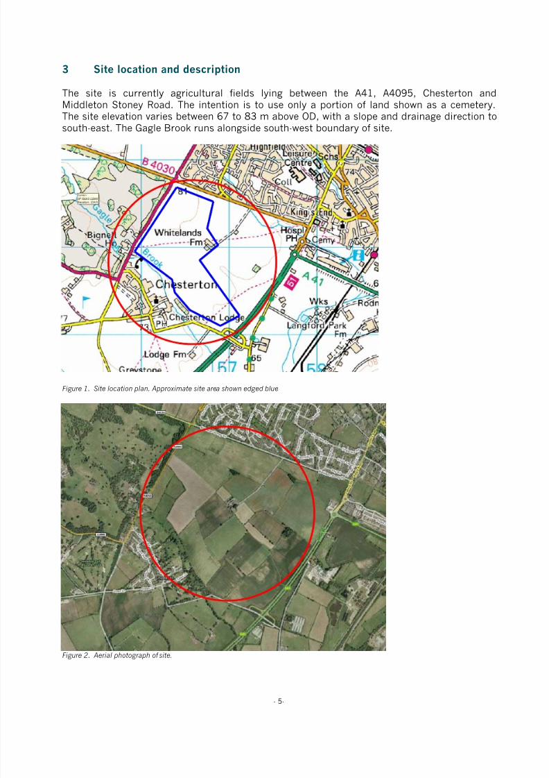
8/3/2019 Relatório RISCO_CEMITÉRIO
http://slidepdf.com/reader/full/relatorio-riscocemiterio 68/96
- 5-
3 Site location and description
The site is currently agricultural fields lying between the A41, A4095, Chesterton andMiddleton Stoney Road. The intention is to use only a portion of land shown as a cemetery.The site elevation varies between 67 to 83 m above OD, with a slope and drainage direction to
south-east. The Gagle Brook runs alongside south-west boundary of site.
Figure 1. Site location plan. Approximate site area shown edged blue
Figure 2. Aerial photograph of site.
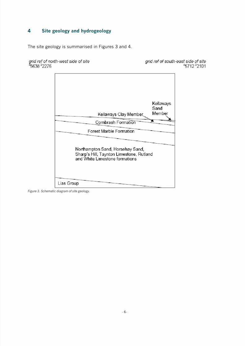
8/3/2019 Relatório RISCO_CEMITÉRIO
http://slidepdf.com/reader/full/relatorio-riscocemiterio 69/96
- 6-
4 Site geology and hydrogeology
The site geology is summarised in Figures 3 and 4.
Figure 3. Schematic diagram of site geology.

8/3/2019 Relatório RISCO_CEMITÉRIO
http://slidepdf.com/reader/full/relatorio-riscocemiterio 70/96
- 7-
Figure 4. Spatial extent of superficial deposits overlying the site.
4.1 Superficial Deposits (Drift)
Adjoining the south-west boundary of the site, Gagle Brook is flanked by a narrow tract ofalluvium of late Quaternary age, comprising sandy silty calcareous clay overlying gravellysandy silty clay, with limestone clasts. It is between 40 m and about 250 m wide, is generally1 to 2 m in thickness, and is unlikely to exceed 4 m in thickness. It may locally include highlycompressible, organic-rich (peaty) layers.
Apart from this, there are no superficial deposits mapped at the site.
4.2 Rockhead Depth
Bedrock is mapped at outcrop across the whole site and it is likely that rockhead is within 1 mof the surface, beneath any artificial ground and unmapped superficial deposits.
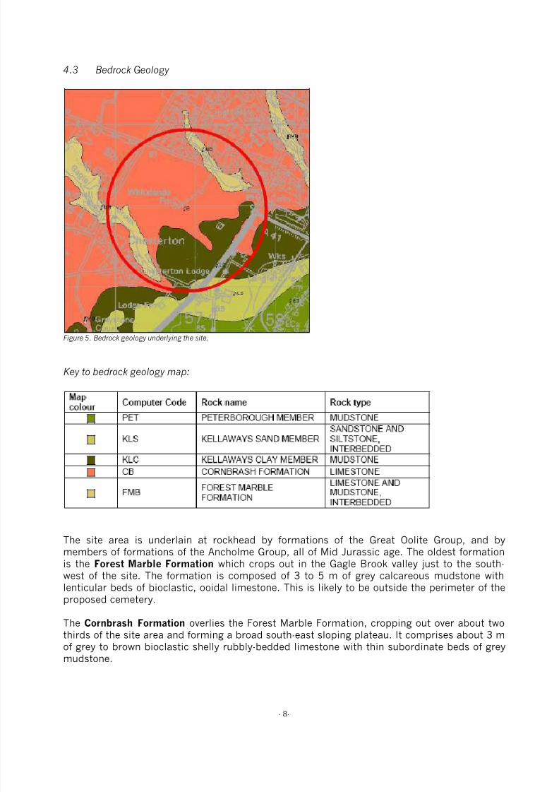
8/3/2019 Relatório RISCO_CEMITÉRIO
http://slidepdf.com/reader/full/relatorio-riscocemiterio 71/96
- 8-
4.3 Bedrock Geology
Figure 5. Bedrock geology underlying the site.
Key to bedrock geology map:
The site area is underlain at rockhead by formations of the Great Oolite Group, and bymembers of formations of the Ancholme Group, all of Mid Jurassic age. The oldest formationis the Forest Marble Formation which crops out in the Gagle Brook valley just to the south-west of the site. The formation is composed of 3 to 5 m of grey calcareous mudstone withlenticular beds of bioclastic, ooidal limestone. This is likely to be outside the perimeter of theproposed cemetery.
The Cornbrash Formation overlies the Forest Marble Formation, cropping out over about twothirds of the site area and forming a broad south-east sloping plateau. It comprises about 3 mof grey to brown bioclastic shelly rubbly-bedded limestone with thin subordinate beds of grey
mudstone.

8/3/2019 Relatório RISCO_CEMITÉRIO
http://slidepdf.com/reader/full/relatorio-riscocemiterio 72/96
- 9-
In the south-east it is overlain by the Kellaways Formation, which is the youngest bedrock unitwithin the site area, and is divided into a lower Kellaways Clay Member, comprising 1 to 3 mof dark grey mudstone, and an upper Kellaways Sand Member, comprising grey silty fine-grained sand or sandstone and siltstone, which is present in the extreme south of the site, andis likely to be less than 1 m in thickness. The Kellaways Clay Member has a moderate shrink-
swell susceptibility.
The limestone-dominated Cornbrash may be affected by dissolution leading to the widening ofjoints and the formation of linear vertical voids, which are likely to fill with rubble and soil.
Additional Geological Considerations:
The Forest Marble Formation is underlain by five further formations of the Great Oolite Group:in ascending order the Horsehay Sand, the mudstone-dominated Sharp’s Hill Formation, theTaynton Limestone, the mudstone-dominated Rutland Formation and the White Limestone
Formation, totalling about 33 m in thickness. These are underlain by about 2 m of theferruginous sandstones of the Northampton Sand Formation. Beneath these are over 80 m ofthe mudstone dominated Lias Group.
The bedrock strata dip very gently (less than 0.5 degrees) to the south-east here. No faultinghas been identified within the site area.
4.4 Hydrogeology and groundwater vulnerability:
Some groundwater may be present in the alluvium, this is likely to be in hydraulic continuitywith the Gagle Brook. This is likely to occur outside the perimeter of the proposed cemetery.
The Kellaways Sand Member is very fine-grained and unlikely to yield significant volumes ofgroundwater. The hydrogeological significance of the underlying Kellaways Clay Member is asa thin potentially confining layer to underlying more permeable formations at depth.
The Cornbrash Formation is also thin, but may contain some groundwater, particularly whereunderlain by low permeability mudstones of the Forest Marble Formation where the water maybe perched.
The Forest Marble Formation contains a mixture of mudstones and limestones, some watermay be present in the latter.
The underlying White Limestone and Taynton Limestone Formations are considered significantaquifers in this area, they are separated by the mudstone dominated Rutland and Sharps HillFormations that act as overlying confining beds and bases to these permeable horizons. Aborehole at Chesterton Lodge (SP 5632 2120) probably terminating in the White Limestonehad a rest water level 7.3 m below ground surface (63 m above OD) and produced a ’good’supply for ‘hardly any depression’. The water was of good quality but hard with a totalhardness of 440 mg/l (as CaCO3), of which 260 mg/l was temporary, the alkalinity was 280mg/l (as CaCO3) and the sulphate ion concentration 192 mg/l. The total dissolved solidscontent was around 550 to 600 mg/l.
Water movement in the limestones of the Great Oolite Group (Cornbrash, Forest Marble, White
Limestone and Taynton Limestone Formations) will take place via fracture flow.

8/3/2019 Relatório RISCO_CEMITÉRIO
http://slidepdf.com/reader/full/relatorio-riscocemiterio 73/96
- 10-
The Horsehay Sand and Northampton Sand Formations together form an aquifer with waterrising significantly above where struck and probably artesian under the lower lying parts of thearea. The 40 m deep borehole at Chesterton Pumping Station (SP 5268 2184, elevation 75 mabove OD) overflowed. (It should be noted that this grid reference is over 3.5 km from theproposed site). Several boreholes in the area have been drilled to exploit this aquifer. A 40 m
deep borehole at Bignall View, Chesterton (SP 5572 21260) produced 3.5 l/s for 15.8 m ofdrawdown after 14 days pumping. Boreholes in the area have produced up to 3.5 l/s fromthese beds. The sands (particularly the Horsehay Sand Formation) may be poorly consolidatedand require support. The water quality is likely to be potable but ferruginous. The borehole atBignall View produced water with a total hardness of 150 to 160 mg/l (as CaCO3), analkalinity of 330 to 380 mg/l (as CaCO3), chloride ion concentration of 25 to 30 mg/l, iron ofup to 1.3 mg/l and fluoride ion concentration of 0.4 mg/l.
The Lias Group is predominantly composed of mudstones and hence generally of lowpermeability.
The Cornbrash and Forest Marble Formations beneath the site are shown as Minor Aquifer ofhigh vulnerability (high soil leaching potential) on the Environment Agency's GroundwaterVulnerability map of the Northern Cotswolds (sheet 30). The Kellaways Formation was notsubdivided from the overlying Oxford Clay Formation in this area and is classified as NonAquifer, but the Kellaways Sand Member could form a Minor Aquifer. The Great Oolite Grouplimestones are not at outcrop but would be classified as Major Aquifer.

8/3/2019 Relatório RISCO_CEMITÉRIO
http://slidepdf.com/reader/full/relatorio-riscocemiterio 74/96
- 11-
5 Boreholes
The plan below shows the location of boreholes relative to the proposed cemeterydevelopment:
Figure 6. Borehole map.
The borehole at Whitelands Farm is recorded as being 42m in length.

8/3/2019 Relatório RISCO_CEMITÉRIO
http://slidepdf.com/reader/full/relatorio-riscocemiterio 75/96
- 12-
6 Water Wells
The plan below shows the location of water wells relative to the proposed cemeterydevelopment:
Figure 7. Water well map.
The data held on these water wells is very sparse within the BGS report, with no water level or
yield information being recorded on the individual logs for the 3 wells within the area ofinterest.

8/3/2019 Relatório RISCO_CEMITÉRIO
http://slidepdf.com/reader/full/relatorio-riscocemiterio 76/96
- 13-
7 Indicative flood plains
According to the EA’s website, the site does not lie within an indicative flood plain (Figure 8)and is therefore not at significant risk from flooding.
Figure 8. Environment Agency website flood risk map.
• Flooding from rivers or sea without defences
• Extent of extreme flood
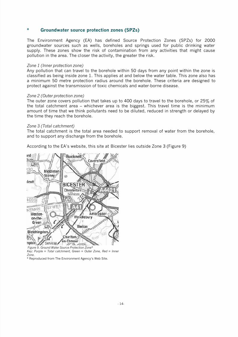
8/3/2019 Relatório RISCO_CEMITÉRIO
http://slidepdf.com/reader/full/relatorio-riscocemiterio 77/96
- 14-
* Groundwater source protection zones (SPZs)
The Environment Agency (EA) has defined Source Protection Zones (SPZs) for 2000groundwater sources such as wells, boreholes and springs used for public drinking watersupply. These zones show the risk of contamination from any activities that might cause
pollution in the area. The closer the activity, the greater the risk.
Zone 1 (Inner protection zone)
Any pollution that can travel to the borehole within 50 days from any point within the zone isclassified as being inside zone 1. This applies at and below the water table. This zone also hasa minimum 50 metre protection radius around the borehole. These criteria are designed toprotect against the transmission of toxic chemicals and water-borne disease.
Zone 2 (Outer protection zone)
The outer zone covers pollution that takes up to 400 days to travel to the borehole, or 25% ofthe total catchment area – whichever area is the biggest. This travel time is the minimum
amount of time that we think pollutants need to be diluted, reduced in strength or delayed bythe time they reach the borehole.
Zone 3 (Total catchment)
The total catchment is the total area needed to support removal of water from the borehole,and to support any discharge from the borehole.
According to the EA’s website, this site at Bicester lies outside Zone 3 (Figure 9)
Figure 9. Ground Water Source Protection Zone* Key: Purple = Total catchment, Green = Outer Zone, Red = Inner Zone. * Reproduced from The Environment Agency’s Web Site.

8/3/2019 Relatório RISCO_CEMITÉRIO
http://slidepdf.com/reader/full/relatorio-riscocemiterio 78/96
- 15-
9 Risk assessment
9.1 Site Vulnerability Assessment
Pertinent criteria, associated comment and assigned score are presented in Tables 4 and 5.
Table 4. Site vulnerability criteria and comment Criteria Comment
Drift Type Absent (except in Gagle Brook area)
Drift Thickness N/A
Depth to Water Table 40m
Flow Mechanism Fracture Flow in Cornbrash & Forest Marble
Aquifer Cornbrash & Forest Marble classified as Minor Aquifers
Abstraction and SPZ Outside Zone 3
Watercourses andsprings
Gagle Brook adjacent to site, therefore develop cemetery >100m frombrook
Drains Not known to be present
Table 5. Site vulnerability assessment score sheet Factor Site Characteristics Ranking Score
Drift type Absent Very High 10 - 9
Drift thickness N/A Very High 10 - 9
Depth to water table 40m Very Low 2 - 1
Flow mechanism Fracture Flow Very High 10 - 9
Aquifer Minor Aquifer Moderate 6 - 5
Abstraction and Source Protection Zone Outside Zone 3 Very Low 2 - 1
Watercourses and springs Leave 100m from brook Very Low 2 - 1
Land Drains None present Very Low 2 - 1
Total (range) 44 - 36
Vulnerability Range Actual
Low vulnerability 8 – 32
Moderate vulnerability 32 – 56 36 – 44
High Vulnerability 56 – 80
9.2 Vulnerability Class
Based upon the total ranking score indicated, the site has been assigned a vulnerability class
of:
Low: Moderate: X High:
9.3 Scale of Development
Statistics supplied by Bicester Town Council indicate that the number of full earth burials innew graves in the existing Bicester Cemetery averages 50 per year.
9.4 Level of Risk
The EA level of risk to the number of anticipated burial rates and groundwater vulnerabilityusing a nomograph reproduced in Figure 10.

8/3/2019 Relatório RISCO_CEMITÉRIO
http://slidepdf.com/reader/full/relatorio-riscocemiterio 79/96
- 16-
Figure 10. Schematic relationship between burial rates, vulnerability class and level of risk (from EA R & D Technical Report P223 (1999).
With reference to Figure 10, the level of risk is considered to be ‘High’.

8/3/2019 Relatório RISCO_CEMITÉRIO
http://slidepdf.com/reader/full/relatorio-riscocemiterio 80/96
8/3/2019 Relatório RISCO_CEMITÉRIO
http://slidepdf.com/reader/full/relatorio-riscocemiterio 81/96
- 18-
11 Recommendations
It is recommended that this report and the accompanying BGS report be circulated to the EAand dialogue should be established with the EA to ascertain their requirements for furtherassessment of the south eastern part of this site’s suitability for development as a cemetery.
Subject to the outcome of this dialogue, it is proposed that the site investigation shouldconsist of the following:
1. A topographic survey to provide a basis for designing the cemetery and any necessarydrainage infrastructure.
2. An electro-magnetic induction (EMI) survey to provide a basis for establishing the mostappropriate locations for excavating soil profile pits down to a maximum depth of 3.5 mand installing three dip wells (up to 10 m deep) to monitor ground water depth. TheEMI data would be shown on the site plan to two different depths (200 mm and 1.2 m).
3.
Assessment of the soil profile pits, and to ‘window sample’ material removed during theboring of the dip wells, in terms of the type, condition and physical properties of thesoil exposed. The results will be used to determine factors that may influence theappropriateness of the site for burial purposes and the vulnerability of the environmentto contamination from the proposed development.
4. Monitor the groundwater levels in the dip wells over a winter period, i.e. during theperiod of highest rainfall.
5. Determine any appropriate options for mitigating risk to ground and surface water byimproving the surface and subsurface drainage status.
Depending upon the results of this sampling and analysis, it may be possible to use the site asa cemetery. This may be subject to certain restrictions and the installation of an appropriatedrainage scheme.
8/3/2019 Relatório RISCO_CEMITÉRIO
http://slidepdf.com/reader/full/relatorio-riscocemiterio 82/96
- 19-
Confidentiality
This presentation is confidential and is only for the use of officers of Bicester Town Council.Without the specific consent in writing of TGMS Limited, no copies of this presentation are tobe made and information contained herein should not be communicated to any third party. At
the request of TGMS Limited all copies of this document, in whatever form, are to be returned.
10 Contact details
TGMS LtdUnit 1, Highfield ParcHighfield RoadOakleyBedfordshireMK43 7TA
Tel: 01234 821750Fax: 01234 821751Email: [email protected]

8/3/2019 Relatório RISCO_CEMITÉRIO
http://slidepdf.com/reader/full/relatorio-riscocemiterio 83/96
- 20-
13 Appendices
8/3/2019 Relatório RISCO_CEMITÉRIO
http://slidepdf.com/reader/full/relatorio-riscocemiterio 84/96
- 48-
Publications by key staff
A guide to better soil structure. Booklet based on MAFF funded project SP0305 “A national soilvulnerability-based framework for the provision of farm-specific guidance on the management of soilstructure”. National Soil Resources Institute, Cranfield University, Silsoe, Bedfordshire, MK45 4DT,September 2001.
Alexandrou, A. & Earl, R. (1998). The relationship between the pre-compaction stress, volumetricwater content and initial dry bulk density of soil. Journal of Agricultural Engineering Research 71, 75-80.
Alexandrou, A & Earl, R. (1997). Development of a technique for assessment the behaviour of soilunder load. Journal of Agricultural Engineering Research 68, 169- 180.
Alexandrou, A. & Earl, R. (1995). In situ determination of the pre-compaction stress of a soil. Journalof Agricultural Engineering Research 61, 67-72.
Bulson, H.A.J., Welsh, J.P., Stopes, C.E. & Woodward, L. (1996). Agronomic viability and potential
economic performance of three organic four year rotations without livestock, 1988-1995. Aspects ofApplied Biology 47: Rotations and cropping systems, 277-286.
Churcher, D.W., Greenwood, J.R., Vickers, A.W. Morgan, R.P.C., Coppin, N.J. & Norris, J.E. (1999). Abioengineering demonstration trial, Kent, England. In: Proceedings 2nd International Conference onLandslides, Slope Stability and the Safety of Infrastructures. ISBN 981-04-1537-0.
S.K. Cook, W.F. Cormack, M. Green, J.M. Holland, A.R. Leake and J.P. Welsh. (2000). Farmingsystems for the new Millennium. Aspects of Applied Biology 62. AAB, Wellesbourne, UK.
Davies, D.H.K. & Welsh, J.P. (2002). Weed control in organic cereals and pulses. In: Organic cerealsand pulses (eds) D Younie, BR Taylor, JP Welsh and JM Wilkinson. Chalcombe Publications, Lincoln,
UK. 77-114.
Earl, R. (1998). Tillage - soil, plant and implement considerations. Landwards 53, 17-23.
Earl, R. (1998). Principles of traction and compaction. Landwards 53, 14-16.
Earl, R. (1997). Prediction of trafficability and workability from soil moisture deficit. Soil and TillageResearch 40, 155-168.
Earl, R. (1997). Assessment of the behaviour of field soils during compression. Journal of AgriculturalEngineering Research 68, 147- 158.
Earl, R. (1996). Prediction of trafficability and workability using tensiometers. Journal of AgriculturalEngineering Research 63, 27-34.
Earl, R., Taylor, J.C., Wood, G.A., Bradley, I.T., Waine, T., Welsh, J.P., Godwin, R.J. & Knight, S.M.(2003). Soil factors and their influence on within-field crop variability, Part I: Field observation of soilvariation. Biosystems Engineering 84(4), 425-440.
Earl, R. & Alexandrou, A. (2001). Deformation processes below a plate sinkage test on sandy loam:theoretical approach. Journal of Terramechanics 38, 153-162.
Earl, R. & Alexandrou, A. (2001). Deformation processes below a plate sinkage test on sandy loam:experimental approach. Journal of Terramechanics 38, 163-183.
Earl, R. & Carter, A.D. (1991). The sampling of water in an unsaturated soil. The Agricultural Engineer46, 50-51.

8/3/2019 Relatório RISCO_CEMITÉRIO
http://slidepdf.com/reader/full/relatorio-riscocemiterio 85/96
- 49-
Earl, R. and Wheeler, P.N. Lined moles cut drainage costs. Arable Farming, June 1993, p 27-32.
Earl, R., Wheeler, P.N., Blackmore, B.S. & Godwin, R.J. (1996). Precision farming - the management ofvariability. Landwards 51(4), 18-23.
Godwin, R.J., Richards, T.E., Wood, G.A., Welsh, J.P. & Knight, S.M. (2003). An economic analysis of
the potential for precision farming in UK cereal production. Biosystems Engineering 84(4), 533-545.
Godwin, R.J., Wood, G.A., Taylor, J.C., Knight, S.M. & Welsh, J.P. (2003). Precision farming of cerealcrops: A review of a six year experiment to develop management guidelines. Biosystems Engineering84(4), 375-391.
Greenwood, J.R., Vickers, A.W., Morgan, R.P.C., Coppin, N.J. & Norris, J.E. (2001). Bioengineering: TheLongham Wood Cutting field trial. CIRIA Project report 81. ISBN 0 86017 881 1.
Gregory, A.S., Kendall, B.A., Earl, R. & Vickers, A.W. (2002). The effects of engineering practices andincorporation of amendments on soil structural development in a clay soil-forming material used as alandfill restoration cap. A report for shanks first fund.
Gregory, A.S. & Vickers, A.W. (2004). The effects of amendments on soil structural development in aclay soil-forming material used as a landfill restoration cap. Soil Use and Management.
Kendall, B.A., Gregory, A.S., Earl, R., & Vickers, A.W. (2001). The effects of engineering practices andamendments on soil structural development in a clay landfill restoration cap. In: Eighth InternationalWaste Management and Landfill Symposium. 1st - 5th October 2001. Sardinia, Italy. Proceedings.Volume 4. pp 371-380.
Morgan, R.P.C., Mcintyre, K., Vickers., A.W.V., Quinton, J.N. & Rickson, R.J. (1997). A rainfallsimulation study of soil erosion on rangeland in Swaziland. Soil Technology 11, 291-299.
Pearce, B.D., Wolfe, M.S. & Welsh, J.P. (2002). Review of knowledge of the potential impacts ofgenetically modified organisms (GMO) on organic agriculture. In: Proceedings of the 14th IFOAM WorldCongress, Canada.
Philipps, L., Welsh, J.P., Bulson, H.A.J. & Woodward, W. (1999). Agronomic viability and potentialeconomic performance of three organic four year rotations without livestock, 1988-1998. Proceedingsof the 12th IFOAM Conference - Organic Agriculture: Credible Solutions for the 21st Century, Argentina.109-115.
J Powell, G Davies, S Fowler, M Hovi, N Lampkin, M Lennartsson, S Padel, B Pearce, L Philipps, JRobertson, E Stockdale, C Watson, R Weller, J Welsh and M Wolfe. (2002). Proceedings of the UKOrganic Research 2002 Conference. Organic Centre Wales, Aberystwyth, UK.
Reeve, M.J. and Earl, R. (1990). The effect of soil strength on agricultural and civil engineering fieldoperations. Soil Survey Report, MAFF Contract 3806.
Schmidt, H., Philipps, L., Welsh, J.P. & Fragstein, P.V. (1999). Legume breaks in stockless organicfarming rotations: Nitrogen accumulation and influence on the following crops. Biological Agricultureand Horticulture 17, 159-170.
Spoor, G., Earl, R. and Wheeler, P.N. (1992). Development of lower cost drainage systems for heavysoils. HGCA Project Report No 64.
Spoor, G, Hann, M J, Godwin, R J, Leeds-Harrison, P B, Miller, S M. (1987). Machinery Developmentsfor Reducing Draught and Improving the Grading Characteristics of Mole Ploughs. ASAE 5th National
Drainage Symposium.

8/3/2019 Relatório RISCO_CEMITÉRIO
http://slidepdf.com/reader/full/relatorio-riscocemiterio 86/96
- 50-
Taylor, J.C., Wood, G.A., Earl, R. & Godwin R.J. (2003). Soil factors and their influence on within-fieldcrop variability, Part II: Spatial analysis and determination of management zones. BiosystemsEngineering 84(4), 441-453.
Taylor, J.C., Wood, G.A., Welsh, J.P. & Knight S. (2000). Exploring management strategies forprecision farming of cereals assisted by remote sensing. Aspects of Applied Biology 60: Remote
Sensing in Agriculture, 53-60.
Thomasson, A.J., Carter, A.D., Jones, R.J.A., Leverton, R.E., Earl, R., Bouma, J., Van Wijk, A.L.M.,Feddes, R.A., Van Lanen, H.A.J., Kabat, P. And Hack-ten Broeke, M.J.D. (1989). Use of modernphysical field methods and computer simulation for land evaluation purposes. Report to EC DG VI,Research Contract No 5711.
Toyne, K. & Vickers, A.W. (2003). Critical evaluation of the ASTM method of measuring percolationrates of rootzones materials. Paper presented at National Turfgrass Foundation National Conference,Southport. November 2003.
Vickers, A.W. & James, I.T. (2003). Management of cracking in clay soils used for cricket pitches.
Paper presented at the Institute of Groundsmanship Annual Conference, Leicester, April 2003.
Vickers, A.W. (2002). Experimental Design for evaluation of products for sportsturf. Paper presented atNational Turfgrass Foundation National Conference, Southport. November 2002.
Vickers, A.W. (2001). Optimisation of rolling on cricket pitches. Paper presented at the 2001 Institute ofGroundsmanship Annual Conference, Haydock.
Vickers, A.W. (2001). Soil water management for sports surfaces. Paper presented at the 2001Institute of Groundsmanship Annual Conference, Haydock.
Vickers, A.W. & Morgan, R.P.C. (1999). Soil water monitoring to assess the effectiveness of three
bioengineering treatments on an unstable Gault Clay cutting in Southern England. In: Proceedings 2ndInternational Conference on Landslides, Slope Stability and the Safety of Infrastructures. ISBN 981-04-1537-0
Vickers, A.W. (1994). A simple field erodibility index based on some English soils. In: Conserving SoilResources, European Perspectives. Edit. R.J. Rickson. CAB International. pp 70 - 78.
Welsh, J.P., Philipps, L. & Cormack, W.F. (2002). The long-term agronomic performance of organicstockless rotations. In: Proceedings of the UK Organic Research 2002 Conference. Organic CentreWales, Aberystwyth, UK. 47-50.
Welsh, J.P., Wolfe, M.S. & Pearce, B.D. (2002). The performance of cereal varieties under organicsystems in on-farm trials in England. In: Proceedings of the 14th IFOAM World Congress, Canada.
Welsh, J.P., Wolfe, M.S., Snape, J. & Pearce, B.D. (2002). Generating and evaluating a novel geneticresource in wheat in diverse environments. In: Proceedings of the 14th IFOAM World Congress, Canada.311.
Welsh, J.P. & Wolfe, M.S. (2002). The performance of variety mixtures and the potential for populationbreeding in organic farming systems. Proceedings of the ECO-PB Symposium: Organic seed production& plant Breeding – strategies, problems and perspectives, Berlin.
Welsh, J.P., Wood, G.A., Godwin, R.J., Taylor, J.C., Earl, R., Blackmore, S. & Knight, S.M. (2003).Developing strategies for spatially variable nitrogen application in cereals, Part I: Winter barley.Biosystems Engineering 84(4), 481-494.

8/3/2019 Relatório RISCO_CEMITÉRIO
http://slidepdf.com/reader/full/relatorio-riscocemiterio 87/96
- 51-
Welsh, J.P., Wood, G.A., Godwin, R.J., Taylor, J.C., Earl, R., Blackmore, S. & Knight, S.M. (2003).Developing strategies for spatially variable nitrogen application in cereals, Part II: Wheat. BiosystemsEngineering 84(4), 495-511.
Welsh, J.P., Bulson, H.A.J., Stopes, C.E., Froud-Williams, R.J. & Murdoch, A.J. (1999). The criticalweed-free period in organically-grown winter wheat. Annals of Applied Biology 134, 315-320.
Welsh JP, Bulson H A J, Philipps L and Wolfe M. (1999). Weed control strategies for organic cerealcrops. Proceedings of the 1999 Brighton Crop Protection Conference – Weeds. 945-950.
Welsh JP, Bulson H A J, Stopes C E, Froud-Williams R J and Murdoch A J. (1997). Mechanical weedcontrol in organic winter wheat. Aspects of Applied Biology 50: Optimising Cereal Inputs - Its ScientificBasis. 375-384.
Welsh JP, Bulson H A J, Stopes C E, Murdoch A J and Froud-Williams R J. (1997). The critical periodof weed competition and its application in organic winter wheat. Proceedings of the 1997 Brighton CropProtection Conference - Weeds. 105-110.
Welsh JP, Bulson H A J, Stopes C E, Froud-Williams R J and Murdoch A J. (1996). Weed control inorganic winter wheat using a spring-tine weeder. Proceedings of the Second International Weed ControlCongress, Copenhagen. 1127-1132
Wood, G.A., Welsh, J.P., Godwin, R.J., Taylor, J.C., Earl, R. & Knight, S.M. (2003). Real-time measuresof canopy size as a basis for spatially varying nitrogen applications to winter wheat sown at differentseed rates. Biosystems Engineering 84(4), 513-531.
D. Younie, B.R. Taylor, J.P. Welsh & J.M. Wilkinson. (2002). Organic Cereals and Pulses. ChalcombePublications, Lincoln, UK.
Zimbone, S.M., Vickers, A.W., Morgan, R.P.C. & Vella, P. (1996). Field investigations of different
techniques for measuring soil surface shear strength. Soil Technology. 9. pp 101 – 111.
8/3/2019 Relatório RISCO_CEMITÉRIO
http://slidepdf.com/reader/full/relatorio-riscocemiterio 88/96
- 52 -
TGMS Limited
Terms and Conditions for the Supply of Services
Interpretation
In these Conditions
AGREED FEE means the charges agreed between TGMS and the Client in relation to
the Specified Service
CLIENT means the person named on the Specification Sheet for whom TGMS has
agreed to provide the Specified Service in accordance with these Conditions
CONTRACT means the contract for the provision of the Specified Service
DOCUMENT includes, in addition to a document in writing, any map, plan, graph,
drawing or photograph, any film, negative, tape or other device embodying visual images
and any disc, tape or other device embodying any other dataINPUT MATERIAL means any Documents or other materials, and any data or other
information provided by the Client relating to the Specified Service
OUTPUT MATERIAL means any Documents or other materials, and any data or other
information provided by TGMS relating to the Specified Service
SPECIFICATION SHEET means the sheet to which these Conditions are appended
SPECIFIED SERVICE means the service relating to geophysical surveys of land to be
provided by TGMS for the Client and referred to in the Specification Sheet
TurfTrax Ground Management Systems means TGMS Limited (registered in England
under number 06623973)
The headings in these Conditions are for convenience only and shall not affect their
interpretation.
Supply of the Specified Service
TGMS shall provide the Specified Service to the Client subject to these Conditions. Any
changes or additions to the Specified Service or these Conditions must be agreed in
writing by TGMS and the Client.
The Client shall allow TGMS adequate access to its property at reasonable times and for
so long as is necessary to enable TGMS to provide the Specified Service in accordance
with the Contract.
The Client shall at its own expense supply TGMS with all necessary Documents or othermaterials, and all necessary data or other information relating to the Specified Service,
within sufficient time to enable TGMS to provide the Specified Service in accordance
with the Contract. The Client shall ensure the accuracy of all Input Material.
TGMS shall have no liability for any loss or damage, however caused, to the Input
Material. All Output Material shall be at the sole risk of the Client from the time of
delivery to or to the order of the Client.
The Specified Service shall be provided in accordance with the Specification Sheet
subject to these Conditions.
Further details about the Specified Service, and advice or recommendations about its
provision or utilisation, which are not given in TGMS’s brochure or other promotional
literature, may be made available on written request.
TGMS may correct any typographical or other errors or omissions in any brochure,
promotional literature, quotation or other document relating to the provision of the
Specified Service without any liability to the Client.
TGMS may at any time without notifying the Client make any changes to the Specified
Service which are necessary to comply with any applicable safety or other statutory
requirements, or which do not materially affect the nature or quality of the Specified
Service.Charges
Subject to any special terms agreed, the Client shall pay the Agreed Fee and any
additional sums which are agreed between TGMS and the Client for the provision of the
Specified Service or which, in TGMS’s sole discretion, are reasonably incurred as a result
of the Client’s instructions or lack of instructions, the inaccuracy of any Input Material or
any other cause attributable to the Client.
All charges quoted to the Client for the provision of the Specified Service are exclusive of
any Value Added Tax, for which the Client shall be additionally liable at the applicable
rate from time to time.
TGMS shall be entitled to invoice the Client on completion of the Specified Service.
The Agreed Fee and any additional sums payable shall be paid by the Client (together
with any applicable Value Added Tax, and without any set-off or other deduction) within
30 days of the date of TGMS’s invoice.
If payment is not made on the due date, TGMS shall be entitled, without limiting any
other rights it may have, to charge interest on the outstanding amount (both before and
after any judgment) at the rate of 4 % above the base rate from time to time of Barclays
Bank plc from the due date until the outstanding amount is paid in full.
Rights in Input Material and Output Material
The property and any copyright or other intellectual property rights in:any Input Material shall belong to the Client
any Output Material and any amendments or variations to the Input Material made by
TGMS shall, unless otherwise agreed in writing between the Client and TGMS, belong to
TGMS, subject only to the right of the Client to use the Output Material for the purposes
of utilising the Specified Service.
Any Input Material or other information provided by the Client which is so designated by
the Client and any Output Material shall be kept confidential by TGMS, and all Output
Material or other information provided by TGMS which is so designated by TGMS shall
be kept confidential by the Client; but the foregoing shall not apply to any Documents or
other materials, data or other information which are public knowledge at the time when
they are so provided by either party, and shall cease to apply if at any future time they
become public knowledge through no fault of the other party.
The Client warrants that any Input Material and its use by TGMS for the purpose of
providing the Specified Service will not infringe the copyright or other rights of any third
party, and the Client shall indemnify TGMS against any loss, damages, costs, expenses or
other claims arising from any such infringement.
Warranties and Liability
TGMS warrants to the Client that the Specified Service will be provided using reasonablecare and skill and, as far as reasonably possible, in accordance with the Specification and
at the intervals and within the times referred to in the Specification Sheet. Where TGMS
supplies in connection with the provision of the Specified Service any goods (including
Output Material) supplied by a third party, TGMS does not give any warranty, guarantee
or other term as to their quality, fitness for purpose or otherwise, but shall, where
possible, assign to the Client the benefit of any warranty, guarantee or indemnity given by
the person supplying the goods to TGMS.
TGMS shall have no liability to the Client for any loss, damage, costs, expenses or other
claims for compensation arising from any Input Material or instructions supplied by the
Client which are incomplete, incorrect, inaccurate, illegible, out of sequence or in the
wrong form, or arising from their late arrival or non-arrival, or any other fault of the
Client.
Except in respect of death or personal injury caused by TGMS’s negligence, or as
expressly provided in these Conditions, TGMS shall not be liable to the Client by reason
of any representation (unless fraudulent), or any implied warranty, condition or otherterm, or any duty at common law, or under the express terms of the Contract, for any loss
of profit or any indirect, special or consequential loss, damage, costs, expenses or other
claims (whether caused by the negligence of TGMS, its servants or agents or otherwise)
which arise out of or in connection with the provision of the Specified Service or their use
by the Client, and the entire liability of TGMS under or in connection with the Contract
shall not exceed the amount of TGMS’s charges for the provision of the Specified
Service, except as expressly provided in these Conditions.
TGMS shall not be liable to the Client or be deemed to be in breach of the Contract by
reason of any delay in performing, or any failure to perform, any of TGMS’s obligations
in relation to the Specified Service, if the delay or failure was due to any cause beyond
TGMS’s reasonable control.
Termination
Either party may (without limiting any other remedy) at any time terminate the Contract
by giving written notice to the other if the other commits any breach of these Conditions
and (if capable of remedy) fails to remedy the breach within 30 days after being required
by written notice to do so.
Insolvency of Client
This clause applies if:
the Client makes any voluntary arrangement with its creditors or (being an individual orfirm) becomes bankrupt or (being a company) becomes subject to an administration order
or goes into liquidation (otherwise than for the purposes of amalgamation or
reconstruction); or
an encumbrance takes possession, or a receiver is appointed, of any of the property or
assets of the Client; or
the Client ceases, or threatens to cease, to carry on business; or
TGMS reasonably apprehends that any of the events mentioned above is about to occur in
relation to the Client and notifies the Client accordingly. If this clause applies then, without prejudice to any other right or remedy available to
TGMS, TGMS shall be entitled to cancel the Contract or suspend any further provision of
services under the Contract without any liability to the Client, and if the Services have
been provided but not paid for the price shall become immediately due and payable
notwithstanding any previous agreement or arrangement to the contrary.
General
These Conditions (together with the terms, if any, set out in the Specification Sheet)
constitute the entire agreement between the parties, supersede any previous agreement or
understanding and may not be varied except in writing between the parties. All other
terms and conditions, express or implied by statute or otherwise, are excluded to thefullest extent permitted by law.
Any notice required or permitted to be given by either party to the other under these
Conditions shall be in writing addressed to the other party at its registered office or
principal place of business or such other address as may at the relevant time have been
notified pursuant to this provision to the party giving the notice.
No failure or delay by either party in exercising any of its rights under the Contract shall
be deemed to be a waiver of that right, and no waiver by either party of any breach of the
Contract by the other shall be considered as a waiver of any subsequent breach of the
same or any other provision.
If any provision of these Conditions is held by any competent authority to be invalid or
unenforceable in whole or in part, the validity of the other provisions of these Conditions
and the remainder of the provision in question shall not be affected.
Any dispute arising under or in connection with these Conditions or the provision of the
Specified Service shall be referred to arbitration by a single arbitrator appointed by
agreement or (in default) nominated on the application of either party by the President for
the time being of Institute of Arbitrators.
English law shall apply to the Contract, and the parties agree to submit to the
non-exclusive jurisdiction of the English courts.
Author: Dr Richard Earl
Released by: Dr James Welsh
Signed:
Date: 16th July 2008
Standard Terms and Conditions
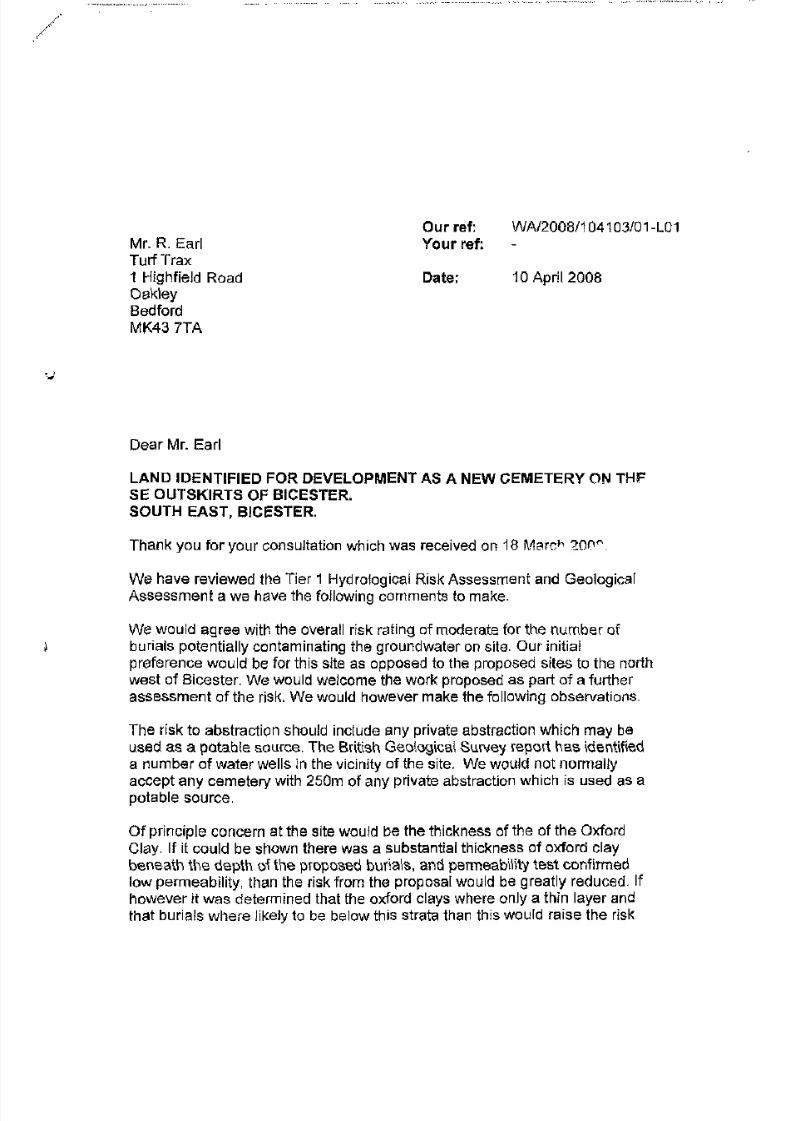
8/3/2019 Relatório RISCO_CEMITÉRIO
http://slidepdf.com/reader/full/relatorio-riscocemiterio 89/96

8/3/2019 Relatório RISCO_CEMITÉRIO
http://slidepdf.com/reader/full/relatorio-riscocemiterio 90/96
8/3/2019 Relatório RISCO_CEMITÉRIO
http://slidepdf.com/reader/full/relatorio-riscocemiterio 91/96
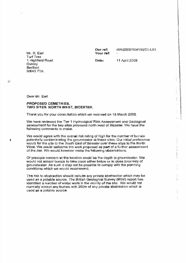
8/3/2019 Relatório RISCO_CEMITÉRIO
http://slidepdf.com/reader/full/relatorio-riscocemiterio 92/96

8/3/2019 Relatório RISCO_CEMITÉRIO
http://slidepdf.com/reader/full/relatorio-riscocemiterio 93/96

8/3/2019 Relatório RISCO_CEMITÉRIO
http://slidepdf.com/reader/full/relatorio-riscocemiterio 94/96
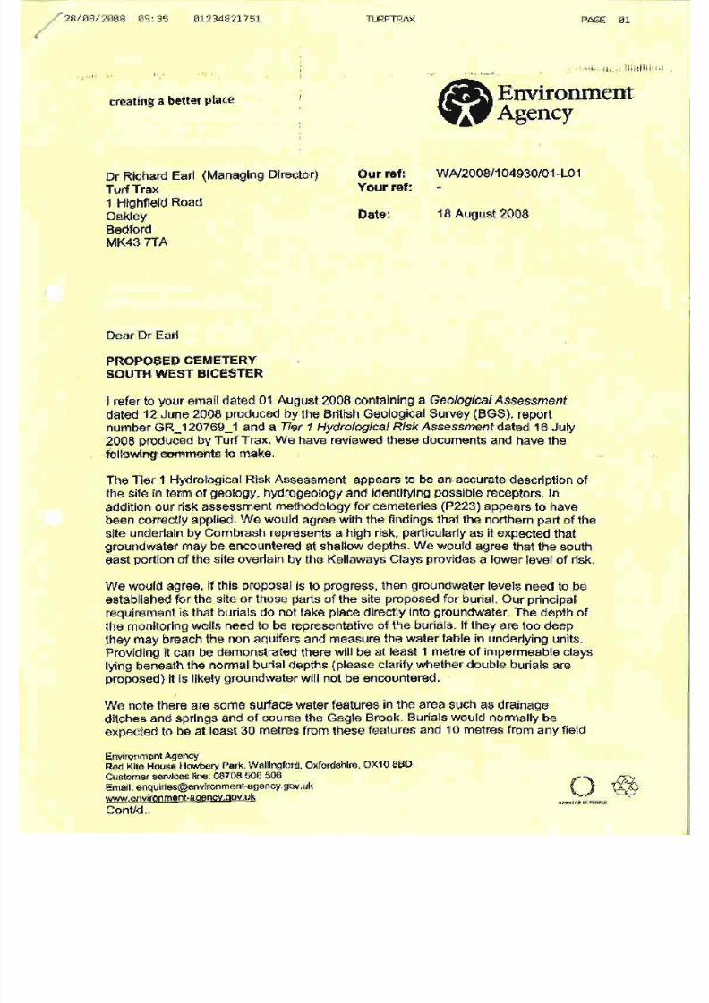
8/3/2019 Relatório RISCO_CEMITÉRIO
http://slidepdf.com/reader/full/relatorio-riscocemiterio 95/96
8/3/2019 Relatório RISCO_CEMITÉRIO
http://slidepdf.com/reader/full/relatorio-riscocemiterio 96/96