RELATIONSHIPS BETWEEN FENG-SHUI AND LANDSCAPES OF CHANGAN...
6
133 213 RELATIONSHIPS BETWEEN FENG-SHUI AND LANDSCAPES OF CHANGAN AND HEIJO-KYO Hideaki Tembata 1 , Shigeyuki Okazaki 1 1 Mukogawa Women’s University, Japan Keywords: Feng-Shui, enclosed space, city planning, landscape, mountain, river, Changan (Xian), Heijo-kyo (Nara) Introduction This paper studies the relationships between the landscapes of Changan (present-day Xian, China) and Heijo-kyo (present-day Nara, Japan) and interpretations based on Feng-Shui, which is a system of thought that originated in China for selecting locations for cities, houses, and graves. We previously studied the relationships between Feng-Shui and landscapes of Seoul, Keasong and Kyoto [1, 2]. In this paper we study Changan and Heijo-kyo. Tong Changan was influenced by Feng-Shui and was one of the largest cities along the Silk Road. Heijyo-kyo was influenced by Feng-Shui and was modeled after Changan [3]. There are a lot of comparative studies between Changan and Heijo-kyo, but most previous studies compare the inside of each capital, and there is no study comparing both from the viewpoint of Feng- Shui thought, including the neighboring geographical environment. Enclosed Space based on Feng-Shui In Feng-Shui, ideal sites are surrounded by mountains and rivers to accumulate “Qi.” Relationships with mountains and rivers are crucial to evaluate invisible “Qi.” In Feng-shui, mountain ranges are regarded as Dragon Pulse, which “Qi” flows through. Figure 1(a) shows the ideal Feng-Shui model [4]. “Ketsu,” which is the most important place, contains the most condensed “Qi” due to enclosed spaces. “Shu-zan” is the main mountain behind “Ketsu.” “Sō-zan” is a mountain that leads to “Shu-zan.” “Qi” comes to “Shu-zan” from “Sō-zan.” Constructing cities, houses, and graves in “Ketsu” brought happiness and prosperity. This model has an axis (Sō-zan - Shu-zan - Ketsu - Myōdō - An-zan - Chō-zan) and a direction called “Zakō.” This model is related to “Shijinsoō”, which means the Four Celestial Animals (Black Tortoise, Green Dragon, White Tiger, and Red Phoenix) are in balance (Fig. 1(b)) [5]. 1 Changan (present-day Xian) Changan was an ancient capital of more than ten dynasties in Chinese history. Changan flourished in the golden age of the Tang Dynasty (618-907), which was founded by the Li family. During its heyday, Changan was one of the largest and most populous cities in the world. Sui Daxing, which was designed by Yuwen Kai, was the predecessor of Tang Changancheng. It is an established theory that city planning of Changan was influenced by Feng-Shui [6, 7]. On the other hand, there is an opinion that Changan does not fit into the ideal Feng-Shui model [8]. Archi-Cultural Translations through the Silk Road 2 nd International Conference, Mukogawa Women’s Univ., Nishinomiya, Japan, July 14-16, 2012 Proceedings
Transcript of RELATIONSHIPS BETWEEN FENG-SHUI AND LANDSCAPES OF CHANGAN...

133
213
RELATIONSHIPS BETWEEN FENG-SHUI AND LANDSCAPES OF CHANGAN AND HEIJO-KYO
Hideaki Tembata1, Shigeyuki Okazaki1 1 Mukogawa Women’s University, Japan
Keywords: Feng-Shui, enclosed space, city planning, landscape, mountain, river, Changan (Xian), Heijo-kyo (Nara)
Introduction
This paper studies the relationships between the landscapes of Changan (present-day Xian, China) and Heijo-kyo (present-day Nara, Japan) and interpretations based on Feng-Shui, which is a system of thought that originated in China for selecting locations for cities, houses, and graves. We previously studied the relationships between Feng-Shui and landscapes of Seoul, Keasong and Kyoto [1, 2]. In this paper we study Changan and Heijo-kyo. Tong Changan was influenced by Feng-Shui and was one of the largest cities along the Silk Road. Heijyo-kyo was influenced by Feng-Shui and was modeled after Changan [3]. There are a lot of comparative studies between Changan and Heijo-kyo, but most previous studies compare the inside of each capital, and there is no study comparing both from the viewpoint of Feng-Shui thought, including the neighboring geographical environment.
Enclosed Space based on Feng-Shui
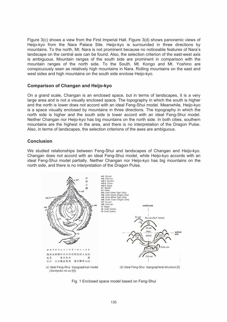
In Feng-Shui, ideal sites are surrounded by mountains and rivers to accumulate “Qi.” Relationships with mountains and rivers are crucial to evaluate invisible “Qi.” In Feng-shui, mountain ranges are regarded as Dragon Pulse, which “Qi” flows through.
Figure 1(a) shows the ideal Feng-Shui model [4]. “Ketsu,” which is the most important place, contains the most condensed “Qi” due to enclosed spaces. “Shu-zan” is the main mountain behind “Ketsu.” “Sō-zan” is a mountain that leads to “Shu-zan.” “Qi” comes to “Shu-zan” from “Sō-zan.” Constructing cities, houses, and graves in “Ketsu” brought happiness and prosperity. This model has an axis (Sō-zan - Shu-zan - Ketsu - Myōdō - An-zan - Chō-zan) and a direction called “Zakō.” This model is related to “Shijinsoō”, which means the Four Celestial Animals (Black Tortoise, Green Dragon, White Tiger, and Red Phoenix) are in balance (Fig. 1(b)) [5].1
Changan (present-day Xian)
Changan was an ancient capital of more than ten dynasties in Chinese history. Changan flourished in the golden age of the Tang Dynasty (618-907), which was founded by the Li family. During its heyday, Changan was one of the largest and most populous cities in the world. Sui Daxing, which was designed by Yuwen Kai, was the predecessor of Tang Changancheng. It is an established theory that city planning of Changan was influenced by Feng-Shui [6, 7]. On the other hand, there is an opinion that Changan does not fit into the ideal Feng-Shui model [8].
Archi-Cultural Translations through the Silk Road2nd International Conference, Mukogawa Women’s Univ., Nishinomiya, Japan, July 14-16, 2012
Proceedings

134
Figure 2(a) shows topographical maps of Changan. On a grand scale, Changan is naturally quite a good site because it is a large flat basin [8]. The Qinling Mountains rise to the east and west to approximately 35 km south. The Weihe River, which is a branch of the Yellow River, flows to the north side of Changan. Changan faces south. During Tang, the main exterior walls of Changan rose 5.5 m high and formed a rectangle extending 9.7 km east to west by 8.6 km north to south with an inner surface area of 78 km2. The castle walls and the roads were symmetrical. On the topographical map, the north and west sides are open and the neighboring mountains are too far, so the impression of being surrounded by the mountains is weak. The south side is higher and the north side is lower.
Figure 2(b) shows a Feng-Shui diagram in Dili-Renzixuezhi (a Feng-Shui book from the Ming Dynasty) [10]. This figure shows Changan equivalent to Supreme Palace enclosure, but there is no explanation about the relations with the actual topography. The Four Celestial Animals are not equivalent to its topography and become the names of the gates of north-south direction, Black Tortoise and Red Phoenix [6]. There is an interpretation that the topography of the Changan meets 64 hexagrams in Yi-king [11]. Atago argued that the central axis of Changan was determined based on the Shibianyu Valley in the Qinling Mountains [12].
Figure 2(c) shows panoramic views of Changan from the former Imperial Palace. To the south, the Qinling Mountains are the most prominent mountains in Changan. Mountains are hardly seen to the north and west. On a grand scale, Changan is an enclosed space, but in terms of landscapes, Changan is not a visually enclosed space. In the Qinling Mountains, there is no characteristic heap of becoming the standard for the central axis. Also, in terms of landscapes, the selection criterion of the east-west axis is ambiguous.
Heijo-kyo (present-day Nara)
Heijo-kyo (present-day Nara) was the capital city of Japan (710-740 and 745-784). According to the Emperor Genmei's words, “the place of Heijo is in accordance with the painting of Shikin (four beasts); Sanzan (three mountains) assuage things (平城之地 四禽図叶 三山作
鎮),” which can be found in the Shoku Nihongi (second of the six classical Japanese history texts), Heijo-kyo was selected based on Feng-Shui, “Shijinsoō” [4, 7, 13].
Figure 3(a) shows a topographical map of Heijo-kyo. Heijo-kyo is surrounded by the mountains and rivers as showed in this figure. Heijo-kyo faces south. It had no castle walls and was an irregular rectangle2, and the area of city is more than 25 km2. The north side is higher and the south side is lower.
The Feng-Shui interpretations of Heijo-kyo are as follows. There are various theories as to an interpretation of “Shijinsoō” and “Sanzan” in Heijo-kyo as follows: (1) Mt. Amanokagu, Mt. Unebi and Mt. Miminashi. (2) To the east, Mt. Kasuga; north Mt. Nara; west Mt. Ikoma. (3) To the east Mt. Mikasa; north, the tomb of the Emperor Heizei; west the tomb of the Emperor Suinin [15, 16]. Sijin is also described in the display in the First Imperial Hall, which was restored, but it is unknown which mountains each Celestial Animal is equivalent to. Huang argued that the central axis matches the Ochioka Hill, which is Red Phoenix. He said that “Sanzan” is "mountains surrounding the Heijo-kyo area," and there is no explanation about relations with the actual mountains [4, 17].
135
Figure 3(c) shows a view from the First Imperial Hall. Figure 3(d) shows panoramic views of Heijo-kyo from the Nara Palace Site. Heijo-kyo is surrounded in three directions by mountains. To the north, Mt. Nara is not prominent because no noticeable features of Nara’s landscape on the central axis can be found. Also, the selection criterion of the east-west axis is ambiguous. Mountain ranges of the south side are prominent in comparison with the mountain ranges of the north side. To the South, Mt. Kongo and Mt. Yoshino are conspicuously seen as relatively high mountains in Nara. Rolling mountains on the east and west sides and high mountains on the south side enclose Heijo-kyo.
Comparison of Changan and Heijo-kyo
On a grand scale, Changan is an enclosed space, but in terms of landscapes, it is a very large area and is not a visually enclosed space. The topography in which the south is higher and the north is lower does not accord with an ideal Feng-Shui model. Meanwhile, Heijo-kyo is a space visually enclosed by mountains in three directions. The topography in which the north side is higher and the south side is lower accord with an ideal Feng-Shui model. Neither Changan nor Heijo-kyo has big mountains on the north side. In both cities, southern mountains are the highest in the area, and there is no interpretation of the Dragon Pulse. Also, in terms of landscapes, the selection criterions of the axes are ambiguous.
Conclusion
We studied relationships between Feng-Shui and landscapes of Changan and Heijo-kyo. Changan does not accord with an ideal Feng-Shui model, while Heijo-kyo accords with an ideal Feng-Shui model partially. Neither Changan nor Heijo-kyo has big mountains on the north side, and there is no interpretation of the Dragon Pulse.
Fig. 1 Enclosed space model based on Feng-Shui

136
Fig. 2 Landscape and Feng-Shui interpretational diagram of Changan

137
Fig. 3 Landscape and Feng-Shui interpretational diagram of Heijyo-kyo

138
Notes
1. Please refer to our previous studies [1, 2] for more information about the basic concept of Feng-Shui and ideal Feng-Shui models.
2. Heijo-kyo was divided by Suzaku Boulevard, the western part of the city was called the Right Capital, and the eastern part the Left capital, which together measured 4.9 kilometers from north to south and 4.3 kilometers from east to west. The Left Capital had an extension, called Gekyo toward the east on its northern half.
References
[1] Tembata, H and Okazaki, S. Enclosed Spaces for Seoul and Kyoto Based on Feng-Shui. “Archi-Cultural Translations through the Silk road,” Bahcesehir University Press, pp.45-54, 2011.10
[2] Tembata, H and Okazaki, S. Enclosed Spaces for Seoul and Kaesong based on Feng-Shui. InterCultural Understanding, Vol. 1, pp.89-97, 2011.3,
[3] Watanabe, A. Structure of Heijo-kyo. Period of Heijo-kyo. pp.26-32, Yoshikawakobunkan, 2010
[4] Murayama, C. Chousen no Feng-Shui. Government-General of Korea, 1931 (1971 reprinted edition) (In Japanese)
[5] Huang, Y. Feng-Shui City -Spatial Composition of Historical City. Gakugei Shuppansha, 1999 (In Japanese)
[6] Watanabe, Y. Feng-Shui and East Asia. Jinbun Shoin, 1990 (In Japanese)
[7] Mezaki, S. Illustration Feng-Shui studies. Tokyoshoseki, 1998 (In Japanese)
[8] Yoon Hong-key. Geomancy and Cities: A Preliminary Inquiry into the Origin of Chinese Geomancy and Its Application on City Locations in East Asia. Urban Morphology and the History of Civilization in East Asia. International Research Center for Japanese Studies, 2004
[9] Maps of Chinese mainland on a scale of one to 50000 No.7. Kagakushoin, 1997 (In Japanese)
[10] Miura, K. Lecture about Feng-Shui, Bungeisyunjyu, 2006 (In Japanese)
[11] Seo, T. City Planning of Changan. Kodansha, 2001 (In Japanese)]
[12] Atago, H. A study on the central axis of Sui and Tong Changan for city planning. Studies on Tong History, No. 3, 2000
[13] Makio, R. Discussion on Feng-Shui Thought. Sankiboubusshorin, 1994
[14] Geospatial Information Authority of Japan. Topological map of 1:25000. 2010 http://www.jmc.or.jp/map/gsi/25k.html (3/2012)
[15] Teramoto, K. Study on Feng-Shui No.2, Genealogy of Four Celestial Animals No.2. Shiseki and Bijyutsu No.75 (9), 2005 (In Japanese)
[16] Shimizu, Y. Thought tied to the earth, Shijin and Sanzan. Sijin, Black Turtle on fresco in Kitora ancient burial mound. Nara National Research Institute for Culture Properties, 2007 (In Japanese)
[17] Huang, Y and Honda, S. Site Selection and Planning of The Center Lines of Ancient Japanese Imperial Capitals: Feng-Shui thought and ancient capitals' city planning. JOURNAL OF ARCHITECTURE AND PLANNING (Transactions of AIJ) No.474, 1995 (In Japanese)
[18] Google. Google map. http://maps.google.co.jp/(13/3/2012)
[19] Zhu shi Guang. Urban Development and Cultural Change in Xian. Urban Morphology and the History of Civilization in East Asia. International Research Center for Japanese Studies, 2004 (In Japanese)