Regulations Summary · 2008 Regulations Summary 3 Special Areas − Regulations Minimum Size Limit...
24
W E S T V I R G I N I A www.wvdnr.gov Regulations Summary
-
Upload
nguyenkien -
Category
Documents
-
view
219 -
download
1
Transcript of Regulations Summary · 2008 Regulations Summary 3 Special Areas − Regulations Minimum Size Limit...

W E S T V I R G I N I A
www.wvdnr.gov
Regulations Summary

From the Director
Public access to fishing and hunting opportunities is a priority of the Division of Natural Resources. Public access for bank and wade fishing, and for launching boats on our state’s rivers, streams and lakes is an important part of resource management and a legacy for our children. While the DNR is diligent in acquiring properties for access, we cannot and do not rely solely on our capabilities. It is abundantly clear that to succeed in providing public access we must partner with a variety of public and private entities and individual landowners. We have long worked with other state agencies, local governments, nongovernmental organizations and individual landowners to establish long-term lease agreements that enhance public access. As suitable access locations become scarcer these partnerships are even more important.
I encourage you to support the DNR public access program by letting us know about opportunities. Our district fisheries and wildlife management staff are excellent initial points of contact. Also, I encourage you and your communities to support public access programs by looking out for illegal and abusive practices by a small number of people who do not appreciate public ownership or management of access areas. Illegal trash dumping and vandalism cost our agency and make it difficult for private landowners to consider partnering with us on access development. When communities join together to deter these activities, the legacy of public access is much safer. Thank you for all that you do to protect the privilege of public access.
Frank Jezioro, Director, West Virginia Division of Natural Resources
District Offices
er these activitiess, or all that you do
al Resources
Main Office - Charleston, WV 25305
State Capitol Complex, Building 3Warmwater Management − Bret Preston (304) 558-2771Law Enforcement − Lt. Col. Jerry Jenkins (304) 558-2784
District 1 - Farmington, WV 26571
1110 Railroad Street (304) 825-6787
Fish Management − Frank JernejcicLaw Enforcement − Capt. Lou Dellamea
District 2 - Romney, WV 26757
1 Depot Street (304) 822-3551
Fish Management − Jim HedrickLaw Enforcement − Capt. Charles Schollar
District 3
WV State Wildlife CenterP.O. Box 38 • French Creek, WV 26218Fish Management − Kevin Yokum (304) 924-6211
Law Enforcement − Capt. Mike Pizzino (304) 637-0245
P.O. Box 67 • Elkins, WV 26241
District 4 - Beckley, WV 25801
2006 Robert C. Byrd Drive (304) 256-6947
Fish Management − Mark ScottLaw Enforcement − Capt. Kaven Ransom
District 5
McClintic WMARt. 1, Box 484 • Pt. Pleasant, WV 25550Fish Management − Zack Brown (304) 675-0871
Law Enforcement − Capt. Steve Stewart (304) 759-0703
4300 1st Avenue • Nitro, WV 25143
District 6 - Parkersburg, WV 26101
2311 Ohio Avenue (304) 420-4550
Fish Management − Scott MorrisonLaw Enforcement − Capt. Dan McKinney
Operations Center - Elkins, WV 26241
Ward Road, P.O. Box 67Coldwater Management − Mike Shingleton (304) 637-0245
Photography provided by West Virginia Division ofNatural Resources andWest Virginia Divisionof Tourism.

New for 2008
Walleye 24-inch minimum size limit and two fish daily creel limit for walleye from Charles Fork and Moncove lakes.
Black Bass Removal of the 12-16 inch slot limit for black bass from East Lynn Lake. General regulations apply.
Dixon Lake Establishment of a catch-and-release regulation for all species, prohibition of barbed hooks and minnows on Dixon Lake, Monongalia County.
Table of Contents
Landowner − Sportsmen RelationsWest Virginia anglers are indebted to local landowners throughout the state. Without their consent and generosity, fishing would be restricted to state and federal lands. The opportunity for continued use of private property is largely dependent upon anglers’ attitudes and conduct. Most stream closures are the result of disrespect for private property.
Statement of Policy Relative to Public Use of FacilitiesIt is the policy of the Division of Natural Resources to provide its facilities, accommodations, services and programs to all persons. Complaints should be mailed to: Director, Division of Natural Resources, State Capitol Complex, Charleston, WV 25305, or to the Office of Human Resources, U.S. Department of the Interior, Fish and Wildlife Service, Hadley, MA 01035-9589. The Division of Natural Resources is an equal opportunity employer.
Regulations ..............................................................................................2-10
Summary .............................................................................................................................2
Special Areas ......................................................................................................................3
Other Methods of Fishing .................................................................................................8
Public Lakes and Ponds ..................................................................................................10
Trophy Fish Citation Program ................................................................9
Fishing .....................................................................................................11-13
Safety .................................................................................................................................11
Favorite Waters .................................................................................................................12
Favorite Float Trips ...........................................................................................................13
2008 License Fees and Information ................................................14-15
Trout Stocking ......................................................................................16-17
Lakes and Ponds ..............................................................................................................16
Streams ..............................................................................................................................17
Fish .......................................................................................................... 18-22
State Record Fish .............................................................................................................18
A Guide to Your Health ....................................................................................................19
2008 WV Consumption Advisories ................................................................................20
Sport Fish Identification ..................................................................................................22
This pamphlet is a summary of the applicable laws and regulations governing sport fishing in West Virginia. The West Virginia Code and the West Virginia Code of Rules contain the details of these laws and regulations. Both publications are available for review in the Director’s Office and Division of Natural Resources District Offices. Copies of the official regulations may be obtained from the West Virginia Secretary of State. Year-round fishing is in effect unless otherwise noted.
Joe Manchin III, Governor
State of West Virginia
Frank Jezioro, Director
Division of Natural Resources
Curtis I. Taylor, Chief
Wildlife Resources
Col. Dave Murphy, Chief
Law Enforcement Section
Commissioners
Jeffrey S. Bowers − Sugar Grove
Byron Chambers − Romney
David F. Truban − Morgantown
David M. Milne − Bruceton Mills
Jan Riffe − Dawson
Gus C. Svokas − Weirton
Kenny Wilson − Chapmanville

2 West Virginia Fishing
SpeciesDaily Creel
LimitMinimum
SizePossession
Limit*Special Regulations
Black BassSmallmouth, Largemouth, and Spotted
6*
(in aggregate)
None* 12*
(in aggregate)
Jennings Randolph Lake: 12-inch minimum size limit, daily creel limit 5, and possession limit 10.
See Special Area Regulationsfor additional restrictions.
TroutRainbow, Golden, Brook and Brown
6*
(in aggregate)
None 12*
(in aggregate)
Jennings Randolph Lake: Daily creel limit 5, and possession limit 5.
See Special Area Regulationsfor additional restrictions.
Muskellunge 2* 30 inches* 4*Jennings Randolph Lake: 36-inch minimum size limit, daily creel limit 1, and possession limit 1 for muskellunge in aggregate with Tiger Musky.
See Special Area Regulationsfor additional restrictions.
Tiger Musky 2* 28 inches* 4*
Northern Pike 2 28 inches* 4*Jennings Randolph Lake: 30-inch minimum size limit, daily creel limit 2, and possession limit 2.
Hybrid Striped Bass 4* 15 inches* 8*
Beech Fork and Bluestone lakes and all rivers: Daily creel limit 4 and possession limit 8 applies to fish 15 inches or larger in aggregate with striped and white bass. No restrictions for these fish under 15 inches.
Mt. Storm, East Lynn and R.D. Bailey lakes: 15-inch minimum size limit.
Striped Bass
4* None* 8*
Beech Fork and Bluestone lakes and all rivers: Daily creel limit 4 and possession limit 8 applies to fish 15 inches or larger in aggregate with hybrid striped, striped, and white bass. No restrictions for these fish under 15 inches.
White Bass
Paddlefish
0 0 0 All fish must be returned to the water immediately.Shovelnose Sturgeon
Lake Sturgeon
Sauger Lakes - 8*
Rivers - 10*
(in aggregate)
None*
Lakes - 16*
Rivers - 20
(in aggregate)
Jennings Randolph Lake: 15-inch minimum size limit, daily creel limit 5, and possession limit 5 for walleye.
See Special Area Regulations for additional restrictions on walleye.
Saugeye
Walleye
Blue Catfish 2* 24 inches* NoneStatewide: 24-inch minimum size limit and daily creel limit 2.
Channel Catfish 4* None 16*
In state-managed impoundments: Daily creel limit 4, possession limit 16. Does not apply to Mt. Storm, Stonecoal, Cheat, U.S. Army Corps of Engineers lakes and all rivers and streams.
See Public Fishing Lakesand Ponds Chart.
Yellow Perch None* None None Cheat Lake: Daily creel limit 15
All Others None* None* None*Jennings Randolph Lake: 14-inch minimum size limit,daily creel limit 5, and possession limit 5 for chain pickerel.
Frogs 10 None 20Season: 9 p.m. DST, June 14 to midnight July 31.
Big Sandy and Tug Fork rivers bordering Kentucky
Season: Noon, May 16 to midnight, October 31.
Check the 2008 Maryland Fishing Regulations for special regulations on the North Branch of the Potomac and Potomac rivers.
Regulations − Summary

2008 Regulations Summary 3
Special Areas − Regulations
Minimum Size Limit
All black bass (smallmouth, spotted and largemouth) 1.
under 12 inches long must be returned to the water at once.
Measure fish from the tip of snout to the end of tail. See 2.
Measuring Fish on page 4.
To release a deeply hooked or gill-hooked fish, cut the 3.
line 5 to 6 inches above the lure.
Lakes
Barboursville, Beech Fork, Chief Logan, and Conaway Run
Streams
Wheeling Creek – Marshall and Ohio counties
Entire length.
Slot Limit
Lakes
All black bass (smallmouth, spotted and largemouth) 1.
from 12 to 16 inches long must be returned to the water at once.
All black bass harvested must be in accordance with the 2.
daily creel limit regulation.
To release a deeply hooked or gill-hooked fish, cut the 3.
line 5 to 6 inches above the lure.
South Mill Creek
Streams
All black bass (smallmouth, spotted and largemouth) 1.
from 12 to 20 inches long must be returned to the water at once.
Daily creel limit of one black bass over 20 inches caught 2.
within the slot limit area. Black bass under 12 inches may be harvested. All black bass harvested must be in accordance with the daily creel limit regulation.
To release a deeply hooked or gill-hooked fish, cut the 3.
line 5 to 6 inches above the lure.
Greenbrier River – Greenbrier County
6-mile section beginning at the U.S. Route 60 bridge near Caldwell extending downstream to the U.S. Route 219 bridge at Ronceverte.
Bass
Catch-and-Release
All black bass (smallmouth, spotted and largemouth) 1.
caught must be returned to the water at once.
No black bass shall be in the angler’s possession (creel 2.
limit 0) while fishing in designated catch-and-release lakes and streams.
To release a deeply hooked or gill-hooked fish, the line 3.
should be cut 5 to 6 inches above the lure.
Lakes
Dunkard Fork, Elk Fork, Kimsey Run, Millers Fork Pond, North Bend, O’Brien, Rockhouse, Stonewall Jackson, Tuckahoe, Upper Mud and Woodrum.
Streams
New River – Fayette, Raleigh and Summers counties
12-mile section from the I-64 bridge at Sandstone downstream to NPS Grandview Sandbar access site near Quinnimont. Access by state Route 41 at Quinnimont and state Route 20 at Sandstone.
South Branch of Potomac River –
Hardy and Hampshire counties
Area 1 8-mile section in Hardy County from 3 miles east of Petersburg at the routes 28, 55 and 220 bridge (Petersburg Gap bridge) downstream to the county Route 13 bridge (Fisher bridge).
Area 2 9.5-mile section in Hampshire County from the routes 28 and 50 bridge (Romney bridge) downstream to the state Route 28 bridge (Blue Beach bridge).
Handling and Release Procedures When practicing catch-and-release fishing, survival of the released fish can be greatly enhanced by following these simple guidelines.
Time is important - play and release the fish as 1.
quickly as possible to reduce unnecessary stress.
Keep the fish in the water as much as possible 2.
and use a pair of forceps or needle-nosed pliers to remove the hook.
Handle the fish with bare, wet hands. Do not 3.
squeeze the fish, put your fingers in the eyes or gills, or cause scale loss.
When releasing the fish, hold it gently in the water 4.
until the fish is ready to swim off on its own.

4 West Virginia Fishing
Children and Class Q Handicap Fishing Areas
Area is managed under special regulations March 1.
through May.
During this period fishing is restricted to children 10 2.
years of age or under and to handicapped individuals holding a Class Q license.
Fishing permitted during daylight hours only.3.
Creel limit is four trout.4.
Another person may assist with baiting hooks and 5.
removing fish.
Coonskin Park Pond – Kanawha County
2.7-acre pond in Coonskin Park. Access by state Route 114 and county Route 51/2.
Handley Pond – Pocahontas County
5-acre pond on the Handley WMA. Access by county routes 17 and 17/1 which intersect U.S. Route 219 at Edray north of Marlinton.
Kanawha State Forest Pond – Kanawha County
1-acre pond in Kanawha State Forest. Access by county Route 42 off county Route 23.
Logan County Airport Pond
1-acre pond. Access by county Route 119/8 off state Route 17.
Millers Fork Pond – Wayne County
5-acre pond on the Beech Fork Lake WMA. Access by county Route 22 off county Route 17.
Raleigh County Airport Pond
1-acre pond at the entrance to the Raleigh County Airport. Access by county Route 9/9 off I-64 at Airport Exit 125-B.
Underwood Lake – Cabell County
1-acre pond on Huntington YMCA property. Access by state Route 2.
Westover Park Pond – Monongalia County
1-acre pond located at the Westover Park just off U.S. Route 19 approximately .5 mile east of I-79 Westover exit.
Wood Pond – Ohio County
.5-acre pond in the Bear Rocks Lake WMA. Access by county Route 41/6.
Woodbine Area of the Cranberry River –
Nicholas County
300-yard section of the Cranberry River at the U.S. Forest Service Woodbine Recreation Area. Access by National Forest Route 76 from Richwood.
Regulations − Special Areas
Muskellunge
Catch-and-Release
Streams
All muskellunge caught must be returned to the water 1.
at once.
No muskellunge shall be in the angler’s possession 2.
while on stream sections designated as catch-and-release streams.
Buckhannon River – Upshur County
6.5-mile section beginning at the City of Buckhannon’s water supply dam and continuing upstream to the first riffle. Included in this area is the section of French Creek from its mouth to the first riffle. The entire stream section is commonly referred to as Buckhannon Pool.
Middle Island Creek – Tyler County
6-mile section beginning at the state Route 18 bridge near Centerville and continuing downstream to the low water bridge near the Jug WMA. Included in this area are sections of Indian Creek and McElroy Creek from their mouth to their first riffle.
Minimum Size Limit
Lakes
All muskellunge under 40 inches long must be returned 1.
to the water at once.
Measure fish from the tip of snout to the end of tail. See 2.
Measuring Fish below.
To release a deeply hooked or gill-hooked fish, cut the 3.
line 5 to 6 inches above the lure.
North Bend Lake
Measuring Fish Lay the fish on top of a ruler on a flat surface.1.
Close the mouth of the fish and squeeze the tail fin 2.
lobes together.
Measure all fish from the tip of the lower jaw to the 3.
tip of the tail. Do not measure along the curvature of the fish’s body.
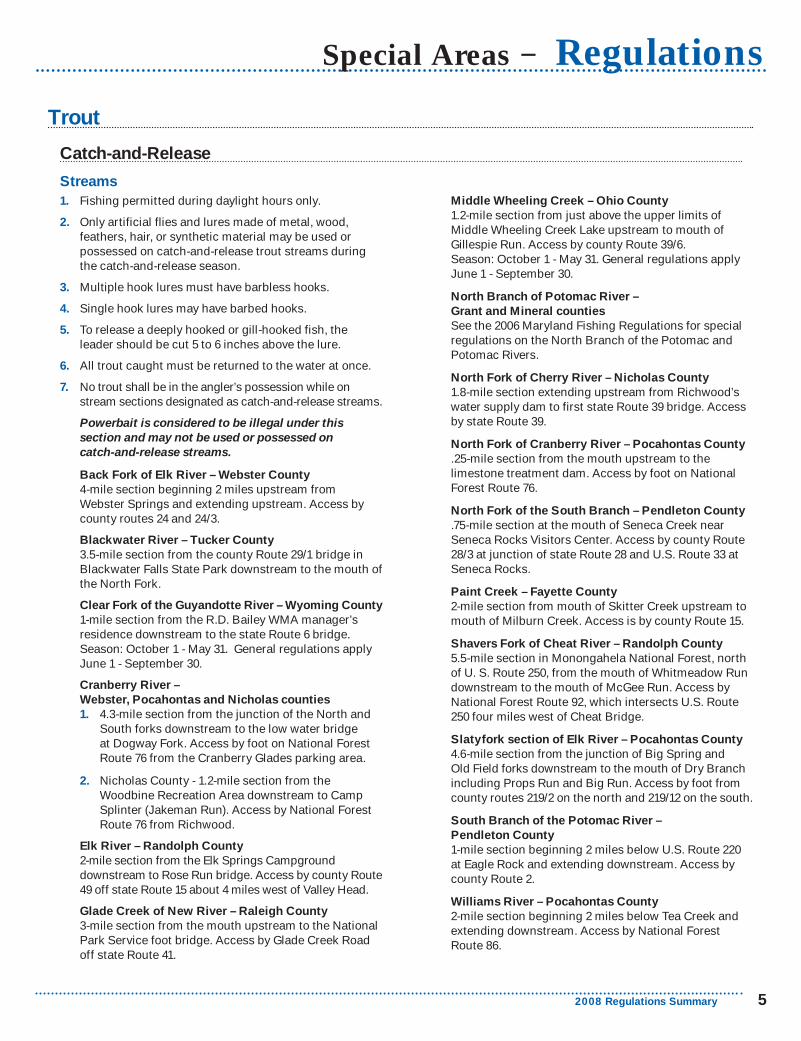
2008 Regulations Summary 5
Trout
Middle Wheeling Creek – Ohio County
1.2-mile section from just above the upper limits of Middle Wheeling Creek Lake upstream to mouth of Gillespie Run. Access by county Route 39/6. Season: October 1 - May 31. General regulations apply June 1 - September 30.
North Branch of Potomac River –
Grant and Mineral counties
See the 2006 Maryland Fishing Regulations for special regulations on the North Branch of the Potomac and Potomac Rivers.
North Fork of Cherry River – Nicholas County
1.8-mile section extending upstream from Richwood’s water supply dam to first state Route 39 bridge. Access by state Route 39.
North Fork of Cranberry River – Pocahontas County
.25-mile section from the mouth upstream to the limestone treatment dam. Access by foot on National Forest Route 76.
North Fork of the South Branch – Pendleton County
.75-mile section at the mouth of Seneca Creek near Seneca Rocks Visitors Center. Access by county Route 28/3 at junction of state Route 28 and U.S. Route 33 at Seneca Rocks.
Paint Creek – Fayette County
2-mile section from mouth of Skitter Creek upstream to mouth of Milburn Creek. Access is by county Route 15.
Shavers Fork of Cheat River – Randolph County
5.5-mile section in Monongahela National Forest, north of U. S. Route 250, from the mouth of Whitmeadow Run downstream to the mouth of McGee Run. Access by National Forest Route 92, which intersects U.S. Route 250 four miles west of Cheat Bridge.
Slatyfork section of Elk River – Pocahontas County
4.6-mile section from the junction of Big Spring and Old Field forks downstream to the mouth of Dry Branch including Props Run and Big Run. Access by foot from county routes 219/2 on the north and 219/12 on the south.
South Branch of the Potomac River –
Pendleton County
1-mile section beginning 2 miles below U.S. Route 220 at Eagle Rock and extending downstream. Access by county Route 2.
Williams River – Pocahontas County
2-mile section beginning 2 miles below Tea Creek and extending downstream. Access by National Forest Route 86.
Special Areas − Regulations
Catch-and-Release
Streams
Fishing permitted during daylight hours only.1.
Only artificial flies and lures made of metal, wood, 2.
feathers, hair, or synthetic material may be used or possessed on catch-and-release trout streams during the catch-and-release season.
Multiple hook lures must have barbless hooks.3.
Single hook lures may have barbed hooks.4.
To release a deeply hooked or gill-hooked fish, the 5.
leader should be cut 5 to 6 inches above the lure.
All trout caught must be returned to the water at once.6.
No trout shall be in the angler’s possession while on 7.
stream sections designated as catch-and-release streams.
Powerbait is considered to be illegal under this section and may not be used or possessed on catch-and-release streams.
Back Fork of Elk River – Webster County
4-mile section beginning 2 miles upstream from Webster Springs and extending upstream. Access by county routes 24 and 24/3.
Blackwater River – Tucker County
3.5-mile section from the county Route 29/1 bridge in Blackwater Falls State Park downstream to the mouth of the North Fork.
Clear Fork of the Guyandotte River – Wyoming County
1-mile section from the R.D. Bailey WMA manager’s residence downstream to the state Route 6 bridge. Season: October 1 - May 31. General regulations apply June 1 - September 30.
Cranberry River –
Webster, Pocahontas and Nicholas counties
4.3-mile section from the junction of the North and 1.
South forks downstream to the low water bridge at Dogway Fork. Access by foot on National Forest Route 76 from the Cranberry Glades parking area.
Nicholas County - 1.2-mile section from the 2.
Woodbine Recreation Area downstream to Camp Splinter (Jakeman Run). Access by National Forest Route 76 from Richwood.
Elk River – Randolph County
2-mile section from the Elk Springs Campground downstream to Rose Run bridge. Access by county Route 49 off state Route 15 about 4 miles west of Valley Head.
Glade Creek of New River – Raleigh County
3-mile section from the mouth upstream to the National Park Service foot bridge. Access by Glade Creek Road off state Route 41.

6 West Virginia Fishing
Fly-fishing-Only
Streams
Fishing permitted during daylight hours only.1.
Only artificial flies and streamers may be used or in 2.
possession on any of the fly-fishing-only streams.
Only conventional fly-fishing tackle may be used. Open-3.
face and closed-face spinning or spincast reels are prohibited.
All fish caught must be returned to water at once.4.
No trout shall be in the angler’s possession while on 5.
stream sections designated as fly-fishing-only streams.
Buffalo Creek of New River – Fayette County
Main stream and all tributaries of Buffalo Creek. Access by foot from county Route 25.
Dogway Fork of the Cranberry –
Webster, Pocahontas and Greenbrier counties
Main stream and all tributaries of Dogway Fork. Access by foot on National Forest Route 78.
Milligan Creek – Greenbrier County
Marked area about 1 mile north of U.S. Route 60 from the county Route 60/15 bridge extending downstream about .33 mile to a fence crossing.
Red Run of Dry Fork – Tucker County
Main stream and all tributaries of Red Run. Access by foot from state Route 72 and National Forest Route 13.
Second Creek – Greenbrier and Monroe counties
Marked 1.5-mile section on the Monroe/Greenbrier county line at Rodgers Mill.
Thorn Creek – Pendleton County
Marked .5-mile section beginning approximately 3 miles above the mouth. Access is by county Route 20.
Walleye
Minimum Size Limit
Rivers
All walleye under 18 inches long must be returned to the 1.
water at once.
Daily creel limit of 2 walleye.2.
Measure fish from the tip of snout to the end of tail. See 3.
Measuring Fish on page 4.
To release a deeply hooked or gill-hooked fish, cut the 4.
line 5 to 6 inches above the lure.
Cheat, Kanawha, New, and Ohio
Lakes
All walleye under 24 inches long must be returned to the 1.
water at once.
Daily creel limit of 2 walleye.2.
Measure fish from the tip of snout to the end of tail. See 3.
Measuring Fish on page 4.
To release a deeply hooked or gill-hooked fish, cut the 4.
line 5 to 6 inches above the lure.
Charles Fork and Moncove
All Species
Catch-and-Release
All species of fish must be returned to the water at once.1.
No fish shall be in the angler’s possession (creel limit 0) 2.
while fishing in designated catch-and-release lakes and streams.
Use of live minnows is prohibited.3.
Use of barbed hooks is prohibited.4.
To release a deeply hooked or gill-hooked fish, the line 5.
should be cut 5 to 6 inches above the lure.
Lakes
Dixon (Pedlar Wildlife Management Area)
Regulations − Special Areas
Trout continued
Regulations Open House
March 17, 2008Fairmont, Lewisburg, Martinsburg, Milton, Spencer, and Summersville
March 18, 2008Buckhannon, Glen Dale, Logan, Moorefield, Parkersburg, and Pipestem Resort State Park
2008 Regulations Summary 7
Special Areas − Regulations
Reciprocal Fishing
or from the Ohio banks of the Ohio River and embayments without obtaining an Ohio license.
Current West Virginia fishing laws shall apply while fishing on the Ohio River proper or from West Virginia banks or in West Virginia embayments. The tributaries of the Ohio River above embayments, in both states, are not included as part of this agreement.
Current Ohio fishing laws apply while fishing from Ohio banks or in Ohio embayments.
Ohio fishing laws and Ohio River fishing regulations for the Eastern Unit, which cover the West Virginia /Ohio border, must be followed while fishing on embayments or tributaries that are within the boundaries of Ohio.
The embayment and tributary reciprocal boundaries for each state are listed in the Waterfowl Hunting and Fishing on the Ohio River brochure available from West Virginia DNR offices, and online at www.wvdnr.gov. Ohio and West Virginia anglers may travel and fish embayments and tributaries to the landmark locations listed in the brochure. These locations are also defined by distance from the mouth of the tributary and GPS coordinates for convenience.
Potomac River
West Virginia residents who possess valid West Virginia fishing licenses may fish by angling in the waters of the Potomac River including the North Branch and Jennings Randolph Lake which are opposite both the West Virginia and the Maryland shores, and they may fish from the Maryland shore, without obtaining a Maryland fishing license, subject, however, to all other Maryland laws, rules and regulations applicable to fishing.
Maryland residents who possess valid Maryland fishing licenses may fish by angling in the waters of Jennings Randolph Lake which are opposite both the Maryland and West Virginia shores, and they may fish from the West Virginia shore of the Potomac River, including the North Branch and Jennings Randolph Lake, without obtaining a West Virginia fishing license, subject, however, to all other West Virginia fishing laws, rules and regulations applicable to fishing. This agreement is limited to the Potomac River including the North Branch and Jennings Randolph Lake and does not extend to any of their tributaries.
The State of Maryland has joint law enforcement jurisdiction on Jennings Randolph Lake.
Ohio River
Ohio residents who carry fishing licenses valid in Ohio may fish on the Ohio River and its embayments or from the West Virginia banks of the Ohio River and embayments without obtaining West Virginia licenses.
West Virginia residents who carry fishing licenses valid in West Virginia may fish on Ohio River embayments in Ohio
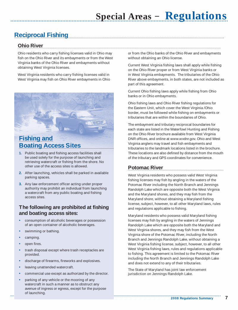
Fishing andBoating Access Sites
Public boating and fishing access facilities shall 1.
be used solely for the purpose of launching and retrieving watercraft or fishing from the shore. No other use of the access sites is allowed.
After launching, vehicles shall be parked in available 2.
parking spaces.
Any law enforcement officer acting under proper 3.
authority may prohibit an individual from launching a watercraft from any public boating and fishing access sites.
The following are prohibited at fishing and boating access sites:
consumption of alcoholic beverages or possession • of an open container of alcoholic beverages.
swimming or bathing.•
camping.•
open fires.•
trash disposal except where trash receptacles are • provided.
discharge of firearms, fireworks and explosives.•
leaving unattended watercraft.•
commercial use except as authorized by the director.•
parking of any vehicle or the mooring of any • watercraft in such a manner as to obstruct any avenue of ingress or egress, except for the purpose of launching.

8 West Virginia Fishing
Regulations − Other Methods of Fishing Except as authorized below, it is illegal to take fish by any means other than by rod, line and hooks.
Ice Fishing Holes cut for ice fishing must be no larger than 10 inches in diameter. This applies to public waters where ice fishing is allowed.
Seining for Minnows/Minnow Traps
Game fish may not be seined or trapped. A seine may be used to obtain minnows for use as bait provided the seine is not longer than six feet nor deeper than four feet. A thrownet may be used provided the diameter is no larger than six feet and mesh size no larger than three-eighths (3/8) inch. Minnow traps may be used provided the openings are not larger than one inch in diameter. A person may have in his possession no more than 50 minnows nor more than a total of 100 aquatic animal life unless obtained from a licensed dealer and a bill of sale is provided. Possession of mussels or any parts thereof is prohibited. A valid West Virginia fishing license is needed to collect minnows and other aquatic life.
Trotlines and Droplines Trotlines and droplines must be attached to the bank ora tree thereon, must bear an identification tag that is legible and waterproof, and must be attended every 24 hours. Wire or cable lines and hooks with more than one point are prohibited.
It is illegal to:
fish with trotlines and droplines in state-managed • impoundments except Stonecoal, Hawks Nest, Mt. Storm, Cheat and U.S. Army Corps of Engineers lakes. (See chart on page 10 for state-managed lakes.)
attach a trotline to public piers and docks or within 50 • feet of dam appurtenances.
use droplines on the Elk River, Hughes River, • Little Kanawha River, Middle Island Creek, and South Fork of Hughes River.
jug fish.•
It is illegal to:
use a firearm, crossbow, dynamite or any like explosive, • or a poisonous mixture placed in the water for the purpose of killing or taking fish, frogs, aquatic turtles or other forms of aquatic life.
fish with more than two (2) lines or poles in an • impoundment stocked with trout by the DNR from January 1 - May 31.
Bow Fishing Carp may be taken by bow year-round; other nongame fish may be taken by bow during all months of the year except May and June. Residents must have a valid fishing license and nonresidents must have a valid hunting license in order to fish using a bow. All persons using a bow to fish must observe all applicable fishing regulations.
It is illegal to:
use an arrow having an explosive head or shaft or an arrow • dipped in or smeared with poison or other chemicals.
Dipping Dipping for nongame fish is legal from February 1 to midnight April 30 with a valid West Virginia fishing license. A dip net may not exceed 36 square feet in overall area, and its mesh may not be smaller than one-fourth (1/4) inch.
Gigging, Snagging and Snaring Suckers, carp, fallfish and creek chubs may be taken by snaring year-round. Other nongame fish, turtles and eels may be taken by gigging, snagging, or snaring from January 1 - May 15 and from July 15 - December 31, except that snagging and gigging shall be prohibited within 100 feet of all U.S. Army Corps of Engineers Locks and Dams and their appurtenances. Snagging of game fish is prohibited.
Hatchery Fish Removal
It is illegal to:
take fish, frogs, aquatic turtles or other aquatic life from • a state fish hatchery.
Free Fishing Days
June 7-8, 2008

2008 Regulations Summary 9
Other Methods of Fishing − RegulationsTrophy Fish Citation Program The trophy fish citation program was initiated to recognize outstanding fishing achievement. The color fish illustrations on the citations are reproductions of original paintings by artist Duane Raver. Applications to register a trophy fish can be obtained from any license agent, Wildlife Resources office or www.wvdnr.gov.
Reporting Procedures
Fish must be legally caught with rod and reel by a • licensed angler in West Virginia.
Carp legally taken by bow and meeting minimum • size requirements qualify for a trophy fish citation.
Fish must meet or exceed the minimum weight • or length.
Fish certified by weight must be weighed on a scale • certified by the West Virginia Division of Labor or at any office of the West Virginia Wildlife Resources Section. Fish must be weighed in the presence of a witness who must sign the application form.
Fish certified by length must be measured in the • presence of a witness who must sign the application form, or fish must be measured and a photograph must accompany the application. Measure total length of fish to nearest 1/8 inch from tip of snout to end of tail. See Measuring Fish on page 4.
A clear side view photograph of the fish is • desirable.
Nonresidents and residents are eligible for trophy • fish citations.
Applications must be submitted within 60 days of • the date of catch.
$5 fee must accompany each application. Make checks • or money orders payable to the West Virginia DNR.
Minimum Sizes
Trout Catfish
Brook 15 in. 1.5 lb. Bullhead 16 in. 2 lb.
Brown 21 in. 4 lb. Channel 25 in. 6 lb.
Rainbow 21 in. 4 lb. Flathead 29 in. 10 lb.
Golden Rainbow 21 in. 4 lb. Blue 29 in. 10 lb.
Bass Crappie 15 in. 1.5 lb.
Largemouth 21 in. 5 lb. Sunfish 10 in. 1 lb.
Smallmouth 20 in. 4 lb. Chain Pickerel 20 in. 2 lb.
Spotted 14 in. 1.5 lb. Northern Pike 32 in. 8 lb.
Rock 11 in. 1 lb. Walleye 25 in. 5 lb.
Striped 25 in. 7 lb. Sauger 17 in. 1.5 lb.
Hybrid Striped 24 in. 7 lb. Yellow Perch 13 in. 1 lb.
White 15 in. 2 lb. Freshwater Drum 27 in. 10 lb.
Muskellunge 40 in. 15 lb. Fallfish 18 in. 2 lb.
Tiger Musky 40 in. 15 lb. Carp 31 in. 15 lb.
Spearfishing and Diving Nongame fish may be taken by spearfishing from July 1.
1 - September 30 during daylight hours only.
Spearfishing is prohibited on the following:2.
Elk River, from Sutton Dam downstream to the •
U.S. Route 19 bridge at Sutton;
New River, from Bluestone Dam downstream to the •
lower bridge at Hinton.
Spearguns may be discharged only beneath the surface 3.
of the water.
It is illegal to use a bolt having an explosive head or 4.
shaft or a bolt dipped in or smeared with poison orother chemicals.
A diver may not spearfish in such a manner as to 5.
interfere with other anglers.
A diver may not spearfish in heavily-traveled boat lanes, 6.
marked swimming areas or marked waterskiing areas.
“Diver down flag” shall be a red 7.
field of not less than 10 inches x 10 inches dimension with a white diagonal stripe not less than 1-1/2 inches wide running upper left to lower right. The flag shall be displayed at all times and be affixed to a separate flotation device. No such flag shall be attached to any navigational device or placed so as to obstruct boat traffic. Divers must come up within 100 feet of flag. All powerboats will remain a minimum distance of 100 feet away from the marker flag. The top of the flag shall be at least 3 feet above the surface of the water.
Fish taken by spearfishing may not be returned to the 8.
water or left on the bank.

10 West Virginia Fishing
Lake or Pond − County Acres Lake or Pond − County Acres
Airport Pond − Raleigh • 1 McClintic Ponds − Mason • 61 • P EAnawalt − McDowell • 7 • Middle Wheeling Creek − Ohio 30 • • EAnderson − Kanawha 7 • Miletree − Roane 10 • EBarboursville − Cabell • 17 P Mill Creek − Barbour • 8 EBear Rock Lakes − Ohio • 16 • E Millers Fork − Wayne • 5Beech Fork − Wayne COE • 720 • • P 10* Moncove − Monroe • 144 • P 5Berwind − McDowell • 20 • P E Mount Storm − Grant 1200 • • U*Big Ditch − Webster • 55 • E Mountain Valley − Summers 39 EBig Run − Marion 7 • • E Mountwood − Wood • 48 • P EBluestone − Summers COE • 2040 • • P U* Newburg Lake − Preston 5Boley − Fayette • 18 C P E New Creek Dam 14 − Grant 40 •Brandywine − Pendleton* • 6 • P E North Bend − Ritchie • 305 • • P 10Brushy Fork − Pendleton 18 • E North Bend State Park − Ritchie 1.5 C PBuffalo Fork − Pocahontas* • 22 • E O’Brien − Jackson 217 • • 10Burnsville − Braxton COE • 968 • • P U* Parker Hollow − Hardy 34 ECacapon − Morgan • 6 • NMf Pedlar Mason − Monongalia • 16 • • ECameron − Marshall 6 • • Pedlar Dixon − Monongalia • 7 •Camp Run − Pendleton* 8 • E Pennsboro W. S. Reservoir − Ritchie 9 • ECastleman Run − Brooke, Ohio • 22 • • E Pipestem − Summers • 16 P RCedar Creek − Gilmer 8 • • P Plum Orchard − Fayette • 202 • P U*Charles Fork − Roane 70 • E Poorhouse Pond − Berkeley 5Cheat Lake − Monongalia • 1730 • • L U* R.D. Bailey − Mingo, Wyoming COE 630 • • P U*Chief Cornstalk − Mason • 5 • P E Ridenour − Kanawha • 27 •Chief Logan − Logan • 7 • Rock Cliff − Hardy* • 17 C P EConaway Run − Tyler • 30 • P E Rockhouse − Logan • 14 ECoonskin Park − Kanawha • 2.5 Rollins − Jackson • 41 • ECoopers Rock − Monongalia • 6 P E Salt Lick Pond 9 − Braxton 15 • • ECurtisville − Marion • 30 • • E Seneca − Pocahontas • 3 P EDoe Run Sub−Impoundment − Taylor 11 • • P E Sherwood − Greenbrier* 165 P P EDog Run − Harrison 15 • E Silcott Fork − Roane 23 •Dunkard Fork − Marshall • 49 • • E Sleepy Creek − Berkeley • 205 • • P EEast Lynn − Wayne COE • 1005 • • P U* South Mill Creek − Grant • 48 • EElk Fork − Jackson • 278 • • 10 Spruce Knob − Randolph* • 23 • P EElk Two Mile (Site 12) − Kanawha 2 Stephens − Raleigh • 300 • • U*Elk Two Mile (Site 13) − Kanawha 3.5 Stonecoal − Lewis, Upshur • 550 • • P 10*Elk Two Mile (Site 14) − Kanawha 4 Stonewall Jackson − Lewis COE • 2650 • • P U*Fitzpatrick − Raleigh 2.5 • P Summersville − Nicholas COE • 2700 • • P U*Flat Run − Marion 6 • • E Summit − Greenbrier* • 43 • P EFt. Ashby − Mineral 12 • • Sutton − Braxton COE • 1500 • • P U*French Creek − Upshur 2 Teter Creek − Barbour • 35 • P EFrozencamp Left Fork − Jackson 20 • E Thomas Park − Tucker 8 • • L EFrozencamp Right Fork − Jackson 20 • E Tomlinson Run − Hancock 30 • P EHandley Pond − Pocahontas • 5 • P E Tracy − Ritchie 11 • L EHawks Nest − Fayette 250 • • U Trout Pond − Hardy 2 • PHorse Creek − Wyoming • 12 • E Tuckahoe − Greenbrier • 40 • EHuey Run − Marion 8 • • E Turkey Run − Jackson • 15 • • EHurricane W.S. Reservoir − Putnam • 12 • Turkey Run − Marshall 15 • • EJames P. Bailey − Mercer • 28 Tygart − Taylor COE 1750 • • P U*Jennings Randolph − Mineral COE 952 • • P U* Tygart River Backwaters − Randolph • 31 • • EJimmy Lewis − Mercer • 15 • E Underwood Lake − Cabell • 1Kanawha State Forest − Kanawha • 1 P Upper Cove Run − Hardy 6.5 • EKee Reservoir − Mercer 70 • E Upper Mud − Lincoln • 307 • • 10Kimsey Run − Hardy • 60 • P E Wallback − Clay • 15 EKrodel − Mason • 22 • P E Warden − Hardy • 44 • ELarenim − Mineral • 10 • NM Watoga − Pocahontas • 11 P ELaurel − Mingo • 29 • P E Westover Park − Monongalia • 1.5Lick Creek − Wayne 5 • • Whetstone − Marion 6 • • ELittle Beaver − Raleigh • 18 P R Wolf Run − Marshall 23 • ELogan County Airport − Logan • 1 E Wood Pond − Ohio • .5Lumberport – Harrison 6 • E Woodrum − Jackson • 240 • • 10
Regulations − Public Lakes and Ponds
Key
Lake - County * = National Forest Stamp required COE = U.S. Army Corps of Engineers lake
Accessibility Use of Live Minnows
Camping L = limited primitive P = permit required
Night Fishing C = registered campers only P = permit required
Boating NM = no motor boats E = electric motors only R = rental boats only U = unlimited h.p. 5 = 5 h.p. maximum 10 = 10 h.p. maximum (Larger motors must have props removed or motor tilted to the maximum limit.) * = contains no wake zones, speed zones and/or other restricted areas f = fee charged for private boats, May 30 - Labor Day
A USCG approved life preserver is required for each occupant of ALL BOATS. See West Virginia Boating Regulations. All boats propelled by machinery must be licensed.
• = the listed feature or activity is available or permitted.A blank space indicates the feature or activity IS NOT available or permitted.

2008 Regulations Summary 11
Boating and Water Safety − Fishing
Boating Education Requirement Anglers using boats must obey boating laws. In West Virginia, anyone born after December 31, 1986 must successfully complete a N.A.S.B.L.A.-approved Boating Education Course before operating a motorboat.
Contact a Conservation Officer for an available course near you. You can also take the online Boating Education Course available at www.wvdnr.gov. Click on boating under the Law Enforcement heading.
Safe Boating Rules Boating accidents usually result from a collision with another boat or an object in the water such as rocks or pilings. A little boating knowledge, common sense and courtesy could prevent most accidents.
Don’t operate a boat under the influence of alcohol • or drugs.
Don’t overload the boat.•
Don’t sit on the edge of the boat.•
If you must stand up, do so carefully away from the sides.•
Drive at a safe speed.•
Use navigation lights at night.•
Keep a lookout for other boats and follow the rules • of navigation.
Always let someone know where you are going and • when you plan to return.
Don’t fish during a thunderstorm.•
Check the weather conditions before you leave. Lightning, strong wind and high waves create hazardous conditions. If caught on a lake in a strong storm, put all fishing gear in the bottom of the boat, stay low in the boat and get off the water as soon as possible. In high waves, the best way to keep from capsizing is to steer the boat at a slight angle into the waves.
Alcohol and Drugs
Operating a boat under the influence of alcohol or drugs creates the same risks and carries the same penalties as DUI. Intoxication affects your balance, which is already challenged by being in a boat. It also affects your coordination, vision and thinking ability. Alcohol also causes you to lose body heat faster should you fall into the water, increasing the risk of hypothermia.
Personal Flotation Devices (PFDs)Personal flotation devices are not just for wearing in boats and not just for those who can’t swim. Anytime you are on or near deep or fast-moving water, it is always best to wear your PFD. Approximately 90 percent of water-related fatalities are the result of drowning. Most accidents are a sudden, unexpected occurrence. If you’re not wearing your life jacket, it will be of little use to you. Make sure the PFD is in good condition and fits properly.
If you are fishing from a boat, West Virginia law requires that you have one PFD on board and readily available for each person on the boat. Any child under 12 years of age must wear a PFD while the boat is in progress. Make sure the PFD is in good condition (try it out in the water from time to time), readily available and fits properly. Boats over 16 feet must also have a ring or cushion on board that can be thrown to a person in the water.
Wading There are several rules you should follow for safe wading.
Wade with a fishing buddy.1.
Wear your PFD.2.
Find out whether the bottom is rocky or muddy.3.
Shuffle your feet or probe with a stick along the bottom 4.
to avoid holes.
Study how swiftly the water is moving.5.
Wear appropriate foot wear (considering water 6.
temperature and bottom substrate).
Person In Water Reach-Throw-Row-Go is a method of rescuing a person who is in trouble in water. If the person is close to you, REACH out with a long object such as an oar or tree limb to pull the person into shore or the boat.
If you can’t reach the person, then THROW them a life-saving device. If possible, it should be tied to the end of a line so you can pull the person to you. An inflatable ball or foam cooler can be used if the proper device is not available.
If there is nothing to throw, ROW a boat to the person in trouble. The person should be pulled in over the stern, or back, of the boat if possible to prevent the boat from tipping over. If the boat has a motor, it must be shut off before you get to the person in the water.
GO (swim) to the person ONLY as a last resort and only if you have had life-saving training. People who are drowning often panic and injure or drown someone trying to rescue them.

12 West Virginia Fishing
Fishing − Favorite Waters
Channel catfish Beech Fork, Bluestone, East Lynn, Burnsville, Stonecoal, Tygart, and Stonewall Jackson lakes; Kanawha, New, South Branch of the Potomac, and Ohio rivers. Most warmwater streams and state managed impoundments.
Best baitsMinnows, night crawlers, chicken livers and natural baits.
Crappie Bluestone, Burnsville, East Lynn, R.D. Bailey, Stonewall Jackson, Sutton, Summersville, and Tygart lakes; Ohio River backwaters.
Favorite baitsMinnows, jigs and minnow-imitating lures.
Hybrid striped bass Kanawha and Ohio rivers; Beech Fork, Bluestone, East Lynn and R.D. Bailey lakes.
Best baitsWhite jigs, silver spoons, shad imitation lures and live minnows.
Largemouth bass Beech Fork, Bluestone, Burnsville, Cheat, East Lynn, R.D. Bailey, Stonewall Jackson and Sutton lakes; Ohio River; most farm ponds and state managed lakes.
Best baitsMinnows, night crawlers, crayfish, crankbaits, spinnerbaits, jigs, soft plastic and most top water lures.
Musky Burnsville, Stonecoal, and Stonewall Jackson lakes; Buckhannon, Elk (downstream of Sutton), Gauley, Hughes, Little Kanawha, Monongahela, Mud, New, and West Fork rivers; Dunkard, Middle Island, Mill and Sandy creeks.
Favorite tackle and baitsBait casting reels using lures imitating minnows; large spinners. Live creek chubs, suckers or large minnows are excellent bait.
Smallmouth bass Summersville and Tygart Lakes; Cacapon, Elk, Greenbrier, Little Kanawha, New, South Branch of the Potomac, mainstream Potomac, Ohio and Shenandoah rivers
Favorite tackle and baitsSpinning tackle of medium-light and ultra-light weight using spinners and other artificial lures resembling minnows, night crawlers, hellgrammites, crayfish, crankbaits, jigs, and numerous soft plastic and topwater baits.
Trout Cranberry, Elk above Webster Springs, South Branch of the Potomac near Franklin, North Fork of the South Branch, Shavers Fork of Cheat and Williams rivers.
Walleye Jennings Randolph, R.D. Bailey, Summersville, Stonecoal, and Tygart lakes; Elk and lower Gauley rivers; Kanawha, Monongahela and Ohio river dam tailwaters.
Best baitsLive minnows, night crawlers, jigs, minnow-imitating crankbaits and spinners.
White bass Tygart Lake; Ohio, Kanawha and Monongahela rivers.
Best baitsJigs, crankbaits, spinners, streamers and live minnows.
Handicap Accessible Fishing Areas For more information on developed sites contact:
West Virginia Division of Natural ResourcesWildlife Resources Section
State Capitol ComplexBuilding 3, Room 808Charleston, West Virginia 25305
(304) 558-2771 or www.wvdnr.gov
2008 Regulations Summary 13
Favorite Float Trips − FishingMany of West Virginia’s streams offer excellent float trip fishing when water conditions are suitable. Some popular trips are listed.
Cacapon River
From To Miles
Wardensville ......................Capon Lake ........................... 8.5
Capon Lake........................Hooks Mill Road Ford .......... 8.0
Hooks Mill Road Ford ......Cold Stream .........................11.0
Cold Stream ......................Rt. 127 Bridge .........................7.0
Rt. 127 Bridge ....................Cacapon Crossings .............. 9.0
Cacapon Crossings ..........Largent South ........................6.7
Largent South ...................Fisher Ford Bridge ...............11.0
Fisher Ford Bridge ............Power Plant ........................... 9.0
Power Plant .......................Route 9 Bridge .....................1.75
Greenbrier River
From To Miles
Renick ................................Anthony Bridge ....................10.0
Anthony Bridge .................Caldwell ................................12.7
Caldwell .............................Ronceverte ............................ 6.0
Ronceverte ........................Fort Spring ............................ 8.5
Fort Spring* .......................Alderson ................................ 6.0
Alderson.............................Pence Springs ....................... 8.5
Pence Springs ...................Talcott Bridge ....................... 4.5
Talcott Bridge** ................Barger Springs ...................... 4.5
Barger Springs ..................Willow Wood Bridge ............ 6.0
* Contains rapids for experienced canoeists only.**Contains two falls to be portaged.
New River
From To Miles
Shanklins Ferry .................Mouth of Indian Creek ......... 6.0
Below Sandstone Falls ....Prince ....................................12.0
Prince .................................Thurmond .............................12.0
Only experienced canoeists should attempt to float the New River. Portaging some areas will be necessary.
South Branch River
From To Miles
Mouth of North Fork ........Petersburg Bridge ................ 4.5
Petersburg Bridge ............Vernon Welton Park ............. 3.0
Vernon Welton Park .........Fisher Bridge South ............. 5.5
Fisher Bridge South ........Fisher Bridge ......................... 2.5
Fisher Bridge .....................Old Fields Bridge .................. 4.5
Old Fields Bridge ..............Trough Entrance (McNeill) ... 5.0
Trough Entrance (McNeill) ..Harmisons ..............................7.0
Harmisons .........................Stony Run ...............................1.5
Stony Run ..........................Romney Bridge ....................8.75
Romney Bridge .................Hanging Rock ....................... 5.0
Hanging Rock ...................Blues Beach Bridge ............. 4.5
Blues Beach Bridge .........Millesons Mill .........................7.5
Millesons Mill ....................Millesons Mill Bridge ........... 2.0
Millesons Mill Bridge .......Blue Ford ..............................4.75
Blue Ford ...........................Indian Rock ........................... 4.0
Indian Rock .......................Mouth ..................................... 4.5
Anglers Alert Anglers are reminded that West Virginia law prohibits the release of fish or other aquatic organisms into public waters, unless a stocking permit is issued by the Division of Natural Resources. Stocking permits are not required for trout and black bass stocking provided that disease-free certifications are obtained prior to stocking, or if trout originate from a source within the state. A permit is not required for stocking native or established fish into privately owned ponds.
Moving live fish or other aquatic animals and plants from one body of water to another can cause long-term damage to the ecological stability of lakes and streams and can threaten recreational fishing. Please take these precautions to prevent problems.
Please:
do not move fish from one body of water to another.•
drain live wells thoroughly before leaving an• access area.
do not release live baitfish or aquarium fish into • West Virginia’s waters.
remove all visible plants and animals from your • boat, motor, trailer and nets before leaving an access area.
By following these simple steps, anglers can help ensure West Virginia’s good fishing for future generations.

14 West Virginia Fishing
Licenses − 2008 Fishing Fees Fishing and Hunting Licenses are good for the calendar year. You must purchase new licenses at the
beginning of each year. All licensed anglers must carry a valid form of photo identification while fishing.
Resident Licenses
Conservation Stamp (Class CS): ....................................... $5
Required for licensed anglers except holders ofClass X, XJ, A-L, B-L, and AB-L licenses
Hunting and Trapping (Class A): .......................................$18
Fishing (Class B): includes National Forest ......................$18
Sportsman Hunting/Fishing/Trapping
(Class X): ........................................................................... $33
for ages 18 through 64
Junior Sportsman Hunting/Fishing/Trapping (Class
XJ): .......................................................................................$15
for ages 15 through 17
Lifetime Licenses
Combination Hunting, Trapping and Fishing
(Class AB-L)*: ................................................................ $760
Combination Hunting, Trapping and
Fishing - Infant (Class AB-L-I)*: .............................. $380
must be purchased before age 2
Fishing (Class B-L)*: .......................................................... $530
Fishing − Infant (Class B-L-I)*: ...................................... $265
must be purchased before age 2
Trout Fishing (Class O-L)**: ............................................. $230
Trout Fishing - Infant (Class O-L-I)**: ...........................$115
must be purchased before age 2
* Conservation Stamp not required.
** Valid only when accompanied by a Class B, AB-L, AB-L I, B-L, B-L-I, X, or XJ license.
Nonresident Licenses
Conservation/Law Enforcement Stamp
(Class CS/LE):...................................................................$12
Required for all licensed anglers
Fishing (Class F): ................................................................... $35
Hunting/Trapping (Class E): .............................................$110
One Day Fishing (Class LL): ................................................. $3
One day
Junior Sportsman Hunting/Fishing/Trapping (Class
XXJ): ....................................................................................$15
for ages 15 through 17
National Forest Hunting/Trapping/Fishing
(Class I): .............................................................................. $2
Required of licensed anglers except for holdersof Class XXJ
Resident and Nonresident Licenses
Trout Fishing Stamp (Class O):
Required of licensed anglers fishing for trout
Resident: ............................................................................$10
Nonresident: ......................................................................$15
Purchasing a License
Licenses may be obtained as follows:1. At over 350 retail agent locations throughout the
state and all county clerks offices. ($3 issuing feefor first purchase and $1 for subsequent purchases.)
2. www.wvfish.com
(Official DNR website − $2 fee per transaction.)
3. Directly from the Hunting and Fishing License Unitby phoning (304) 558-2758. ($2 fee per transaction.)
For additional information please contact:
Hunting and Fishing License Unit
West Virginia Division of Natural ResourcesState Capitol Complex, Building 3, Room 624Charleston, West Virginia 25305
(304) 558-2758 • [email protected]

2008 Regulations Summary 15
Information − Licenses
Fishing License Not Required for Residents who are totally blind. A physician’s statement 1.
or certificate must be carried while fishing.
Residents 65 years of age or older.2.
Nonresidents or residents under 15 years of age.3.
Residents on active duty in the U. S. armed forces 4.
while on military leave. Leave papers shall be carried while fishing.
Resident landowners or their resident children, resident 5.
parents, or bonafide resident tenants of such land may fish on their own land during open seasons in accordance with the laws and regulations applying to such fishing.
Residents honorably discharged from the U. S. armed 6.
forces receiving total permanent service-connected disability benefits or former prisoners of war as determined by the Veterans Administration or resident disabled veterans who qualify under West Virginia Code 17A-10-8 and are exempted from payment of any motor vehicle registration fee by the Commissioner of Motor Vehicles. Such persons must carry a card issued by the DNR.
Residents or in-patients of any state mental hospital, 7.
health or benevolent institution. Such persons must be under proper supervision and carry a written statement or certificate signed by the superintendent of the institution or facility.
Developmentally disabled residents. A DDFL card 8.
issued by the DNR must be carried while fishing.
Violations
Point System for Fishing Violations
Persons making false application for a license will have their license privileges suspended for one year.
Points assigned for other fishing andhunting violations:
10 points for use of explosives or poison material in taking fish
6 points for illegal possession or sale of wildlife4 points for all other violations
When a violator accumulates 10 or more fishing or hunting points combined, his/her license(s) will be revoked for a period of two years.
Points will be removed on their second anniversary or upon restoration of the license(s).
Reporting Boating, Fishing and Hunting Law Violations:
In progress − dial 911
Not in progress − call District Law Enforcement Office during normal operating hours.
Observe and write down all of the information 1.
concerning the violation.
Don’t confront violator.2.
Contact a local Conservation Officer or county 3.
communication center as soon as possible.
Become involved in protecting your sport, be willing to 4.
testify in court.
Stream Pollution or Fish Kills:
Call 1-800-642-3074.
Open Fishing Tournament Sponsors A permit is required from the Division of Natural Resources to hold a tournament that is open to the public or awards cash or prizes. Club tournaments, which are restricted to members competing for points, do not require a permit.
Tournament permit requests should be made to:
West Virginia Division of Natural ResourcesWildlife Resources SectionState Capitol Complex, Building 3, Room 808Charleston, West Virginia 25305
Call (304) 558-2771 for information.
Definition of Resident
A person who has been a domiciled resident continuously in West Virginia for 30 consecutive days or more immediately prior to the date of application for a license or permit. This includes members of the U.S. armed forces stationed outside the state who were West Viginia residents at the time of entry into the service and any full-time student of a college or university of this state.

16 West Virginia Fishing
Code No. Stockings ......Period Code No. Stockings ......Period Code No. Stockings ......Period
Q One ....................1st week of MarchBW
One .................................... February CR Varies ..................................... Varies
W
One ......................................January M One each month ....February−MayOne every two weeks March−May
Two .................................... February MJ One each month .... January−April
BAOne ......................................January
One each week .......... March−May Y One ............................................April
One .........................................MarchX After April 1 or area is open to public F One each week .... October 13 & 20
Trout Stocking − Lakes and Ponds
Lake or Pond − County Code Lake or Pond − County Code
Anawalt − McDowell M Little Beaver − Raleigh MJ
Anderson − Kanawha BA Logan County Airport − Logan Q
Barboursville − Cabell BA Mason Lake − Monongalia M
Bear Rock Lakes − Ohio BW Middle Wheeling Creek − Ohio BW
Beech Fork (Tailwaters) − Wayne M Miletree − Roane BA
Berwind − McDowell M Mill Creek − Barbour M
Big Run − Marion Y Millers Fork − Wayne Q
Boley − Fayette M Mountwood − Wood MJ
Brandywine − Pendleton BW-F Newburg − Preston M
Brushy Fork − Pendleton BW New Creek Dam 14 − Grant BW-F
Buffalo Fork − Pocahontas BW-F Pennsboro W. S. Reservoir − Ritchie BA
Burnsville (Tailwaters) − Braxton BW Pipestem − Summers M
Cacapon − Morgan W Poorhouse − Berkeley M
Castleman Run − Brooke, Ohio BW Raleigh County Airport − Raleigh Q
Cedar Creek − Gilmer BA R.D. Bailey (Tailwaters) − Mingo, Wyoming BW-F
Chief Cornstalk − Mason BA Ridenour − Kanawha BA
Chief Logan − Logan MJ Rock Cliff − Hardy XBW-F
Conaway Run − Tyler M Rockhouse − Logan M
Coonskin Park − Kanawha Q Rollins − Jackson MJ
Coopers Rock − Monongalia BW-F Seneca − Pocahontas BW-F
Curtisville − Marion MJ South Mill Creek − Grant BW
Dog Run − Harrison M Spruce Knob − Randolph W-F
Dunkard Fork − Marshall M Stonewall Jackson (Tailwaters) − Lewis BW
East Lynn (Tailwaters) − Wayne M Summersville (Tailwaters) − Nicholas BW-F
Fitzpatrick − Raleigh MJ Summit − Greenbrier W-F
Ft. Ashby − Mineral BW Sutton (Tailwaters) − Braxton BW-F
French Creek − Upshur BW Teter Creek − Barbour BW-F
Handley − Pocahontas Q Thomas Park − Tucker M
Horse Creek − Wyoming M Tomlinson Run − Hancock MJ
Huey Run − Marion BA Tracy − Ritchie BA
James P. Bailey − Mercer BA Tuckahoe − Greenbrier M
Jennings Randolph (Tailwaters) − Mineral M Turkey Run − Jackson BA
Jimmy Lewis − Mercer M Tygart (Tailwaters) − Taylor M-F
Kanawha State Forest − Kanawha Q Underwood − Cabell Q
Kimsey Run − Hardy BW Wallback − Clay M
Krodel − Mason BA Warden − Hardy BW
Larenim − Mineral BA Watoga − Pocahontas W
Laurel − Mingo MJ Westover Park − Monongalia Q
Lick Creek − Wayne MJ Wood − Ohio Q
Updated daily during Trout Stocking Season: Hunting and Fishing Hotline (304) 558-3399 and online at www.wvdnr.gov

2008 Regulations Summary 17
Stream − County Code Stream − County Code
Anthony Creek − Greenbrier W-F Meadow Creek − Summers MBack Fork of Elk River − Webster M Middle Creek − Berkeley WBack Fork of Elk River (C & R) − Webster CR Middle Fork − Barbour, Randolph, Upshur MBeech Fork Lake (Tailwaters) − Wayne M Middle Wheeling Creek (C&R) − Ohio CRBig Bullskin Run − Jefferson W Mill Creek − Fayette MBig Clear Creek − Greenbrier BW-F Mill Creek − Berkeley WBig Sandy Creek − Preston BW Mill Creek − Hampshire BWBlackwater River − Tucker W-F Milligan Creek − Greenbrier MBlackwater River (C & R) − Tucker CR Mill Run − Berkeley MBlaney Hollow & Morgan Run − Monongalia M Mill Run − Hampshire BWBuckhannon River − Upshur BW-F Moores Run − Hardy MBuffalo Creek − Brooke BW New Creek − Mineral WBuffalo Creek − Logan M North Branch of Potomac River − Mineral MBurnsville Lake (Tailwaters) − Braxton BW North River − Hardy BWCamp Creek − Mercer BW North Fork of Anthony Creek − Greenbrier BWCherry River − Nicholas BW North Fork of Cherry River − Greenbrier, Nicholas BWClear Fork − McDowell M North Fork of Fishing Creek Dam − Wetzel MClear Fork − Wyoming BW North Fork of Lunice Creek − Grant BWClear Fork (C & R) − Wyoming CR North Fork of Patterson Creek − Grant WClover Run − Tucker M North Fork of South Branch − Grant, Pendleton W-FCranberry River − Nicholas, Pocahontas, Webster W-F North Fork of South Branch (C & R) − Pendleton CRCranberry River (C & R) − Nicholas, Pocahontas CR Opequon Creek − Berkeley, Jefferson W-FCranberry River, Woodbine Area − Nicholas Q Paint Creek − Fayette, Kanawha BWDeer Creek − Nicholas M Paint Creek (C & R) − Fayette CRDeer Creek − Pocahontas M Panther Creek − McDowell MDesert Fork − Webster M Paw Paw Creek − Marion BWDillions Run − Hampshire BW Pinch Creek − Raleigh YDry Fork − McDowell M Pinnacle Creek − Wyoming BW-FDry Fork − Randolph, Tucker BW Pond Fork − Boone BW-FDunloup Creek − Fayette M Potts Creek − Monroe MEast Fork of the Greenbrier River − Pocahontas W R.D. Bailey Lake (Tailwaters) − Mingo, Wyoming BW-FEast Lynn Lake (Tailwaters) − Wayne M Red Creek − Tucker BWEast River of New River − Mercer BW Rhine Creek − Preston MEdwards Run − Hampshire BW Right Fork of Buckhannon River − Upshur MElk River − Randolph, Webster W-F Right Fork of Middle Fork − Upshur MElk River (C & R) − Randolph CR Right Fork of Little Kanawha River − Upshur, Webster MElkwater Fork − Randolph M Rocky Marsh Run − Jefferson WEvitts Run − Jefferson W-F Second Creek (C & R) − Greenbrier, Monroe CRFall Run − Webster M Shavers Fork (C & R) − Randolph CRGandy Creek − Randolph W Shavers Fork (Lower Section) − Randolph W-FGlade Creek (Babcock) − Fayette BW Shavers Fork (Upper Section) − Randolph W-FGlade Creek of New River − Raleigh BW-F South Branch (Franklin Section) − Pendleton W-FGlady Fork − Randolph W South Branch (Smoke Hole Section) − Pendleton W-FGreenbrier River − Pocahontas BW South Branch (C & R) − Pendleton CRHills Creek − Pocahontas M South Fork of Cherry River − Greenbrier, Nicholas BWHopkins Fork − Boone M South Fork of Cranberry River − Pocahontas BWHorseshoe Run − Tucker BW South Fork of Fishing Creek − Wetzel MIndian Creek of New River − Summers M South Fork of Potts Creek − Monroe MKings Creek − Hancock M Spruce Laurel Fork − Boone MKnapps Creek − Pocahontas W-F Stonewall Jackson Lake (Tailwaters) − Lewis BWLaurel Creek − Clay M Sugar Creek − Webster MLaurel Creek − Fayette M Summersville Lake (Tailwaters) − Nicholas BW-FLaurel Creek − Greenbrier, Nicholas M Sutton Lake (Tailwaters) − Braxton BW-FLaurel Fork − Randolph W Tilhance Creek − Berkeley BWLaurel Fork − Webster BW Tomlinson Run − Hancock MLeft Fork of Buckhannon River − Upshur M Trout Run − Hardy WLeft Fork of Holly River − Webster BW Tuscarora Creek − Berkeley BWLeft Fork of Right Fork Buckhannon − Randolph, Upshur BW Twelvepole Creek (Wayne Dam) − Wayne MJLittle Clear Creek − Greenbrier BW Tygart Lake (Tailwaters) − Taylor M-FLittle Kanawha River (Headwaters) − Lewis, Upshur M Tygart River (Headwaters) − Randolph BW-FLittle River (East Fork) − Pocahontas W Waites Run − Hardy WLittle River (West Fork) − Pocahontas W West Fork of Greenbrier River − Pocahontas W-FLong Marsh Run − Jefferson M West Fork of Twelvepole Creek − Wayne MLost River − Hardy W-F Wheeling Creek − Marshall, Ohio BWLower Cove Run − Hardy M Whiteday Creek − Marion, Monongalia BWMarsh Fork − Raleigh M Williams River − Pocahontas, Webster W-FMash Fork − Mercer M Williams River (C & R) − Pocahontas CRMeadow Creek − Greenbrier M Wolf Creek − Preston M
Streams − Trout Stocking
18 West Virginia Fishing
Species Yr.Length
(inches)
Weight
(pounds) Location Angler
Bass
Largemouth2001 25.75 9.62 Dog Run Lake Eli Gain1994 24.8 12.28 Pond − Grant Co. David W. Heeter
Smallmouth1976 25.5 7.5 New River Franklin J. Elliott1971 24.25 9.75 South Branch David Lindsay
Rock 1964 13.8 1.75 Big Sandy Creek Warren Ryan
Spotted2000 19.0 4.77 R. D. Bailey Lake Kevin Dameron1988 19.0 3.82 R. D. Bailey Lake Leonard Blankenship
Striped2000 37.68 29.56 Bluestone Lake Terry Watkins2007 40.88 21.38 Bluestone Lake Michael Pittman, Jr.
Hybrid Striped2000 32.1 14.0 Kanawha River Frankie Harris1985 31.5 16.75 Kanawha River Robert Honaker
White 1985 20.0 4.56 New River Louis Puskas
Bluegill1986 11.7 2.75 Pond − Randolph Co. Mark Allen Lewis1964 13.75 2.25 Farm Pond − Fayette Co. Dennis Criss
Bowfin1994 32.25 7.54 Pond − Berkeley Co. Donald E. Newcomb, III2006 28.43 9.25 Ohio River backwater Matt Stender
Buffalo 1976 41.0 38.0 Little Kanawha River Hobert Null
Carp
Common1998 39.3 47.0 Farm Pond − Preston Co. Gary Johnson1988 41.0 41.5 Stonecoal Lake Charles J. Cook
Grass2002 47.1 52.5 Farm Pond − Mason Co. Joseph R. Spencer, II2005 50.75 71.69 Warden Lake William R. Taucher
Catfish
Blue 2005 36.5 24.37 Ohio River Sam MorrisonBullhead 1977 22.75 6.1 Tygart Lake Headwaters Gary R. FreemanChannel 2005 40.3 33.42 Patterson Creek Michael SearsFlathead 1956 52.0 70.0 Little Kanawha River L. L. McCLung
Chain Pickerel 2001 27.75 6.19 Tuckahoe Lake Steven Demma
Crappie 1971 19.75 4.05 Meathouse Fork Leonard Edgell
Eel1983 44.25 6.27 Elk River Steve Woods1977 44.0 7.25 Bunker Hill Quarry Arlie R. Ruble
Fallfish 1970 21.25 3.5 North Fork of So. Branch James BlackwellFreshwater
Drum
1989 35.5 27.0 South Fork of Hughes Charles Mickel Lott1954 37.0 25.0 Little Kanawha River Bill Dawkins
Gar
Longnose2006 52.25 16.42 Kanawha River Shelby Searls1993 50.5 19.08 Kanawha River Michael Shan Casey
Goldeye 1983 18.5 3.0 Ohio River Delbert McWilliams
Muskellunge2003 52.7 38.5 Stonecoal Lake Glenn Boyd1997 50.37 49.75 Stonecoal Lake Anna Marsh
Northern Pike 1989 42.6 22.06 Dog Run Lake Boyd O. Pratt, Sr.
Sauger 1985 23.0 4.75 Ohio River Steve Powell
Saugeye 2006 27.68 8.73 East Lynn Lake Everett Chapman
Skipjack2002 18.4 2.61 Kanawha River Steve Skeens1991 18.6 2.38 Ohio River Elmer Bullard
Tiger Musky 1994 49.25 36.5 Mountwood Lake Clyde E. Beckett
Trout
Brook2004 22.25 7.64 Shavers Fork Gary M. Chapman1981 23.5 4.78 Lost River Jack E. Foltz
Brown 1968 32.0 16.0 South Branch Paul Barker
Golden Rainbow1998 26.4 9.31 Brushy Fork Lake Danny Crider1987 27.5 8.63 Stonecoal Lake Gerald Estep
Rainbow2005 30.5 15.65 Pond − Monroe Co. Aaron Propps1993 31.7 11.74 Stonecoal Lake John P. Arnett
Tiger 1986 26.0 6.68 Greenbrier River John Duncan
Walleye2004 30.87 18.97 Elk River Jerry Rose1976 35.0 15.0 Kanawha Falls Fred Cline
Yellow Perch1985 14.5 1.83 Tygart Lake Charles Mayle2005 15.1 1.43 Pond − Hampshire Co. Chadwick A. Smith
Fish − State Records
Reporting ProceduresA record of the largest fish of each species legally taken with rod and reel by a licensed angler in West Virginia waters is maintained by the Division of Natural Resources. Certificates of accomplishment are awarded for each record holder.
Anglers landing a potential state record fish should report the catch as soon as possible to the district fisheries biologist in the closest DNR district office. Please follow these guidelines to ensure accuracy of reporting.
Name, address, and telephone 1.
number of angler.
Species of fish, where, when, and 2.
how caught.
Total length of fish measured 3.
from tip of snout to end of tail. Lay fish on top of ruler on a flat surface. Close the mouth of the fish and squeeze the tail fin lobes together. Do not measure along the curvature of the fish’s body.
Fish must be weighed on a scale 4.
certified by the West Virginia Division of Labor.
Signatures and telephone 5.
numbers of two persons who witnessed the length and weight measurements.
A DNR fisheries biologist must 6.
verify the species, length, and weight of the fish.
A photograph of the fish is desirable.7.
Your purchaseof fishing equipment
and motor boat fuels supportsSport Fish Restoration and
boating access facilities

2008 Regulations Summary 19
A Guide to Your Health − Fish
Health Benefits of Eating Fish Fish are nutritious and good to eat. When properly prepared, fish provide numerous health benefits, especially for the heart. The American Heart Association recommends eating two to three fish meals each week.
The benefits of eating fish include:
Fish offer high-quality protein with fewer calories than a • similar-sized portion of meat. Example: Both catfish and ground beef are about 18% protein. But, for an 8-ounce meal, the catfish will have only about 232 calories, while the regular ground beef will have about 640 calories.
Fish are low in sodium and are good sources of • potassium, vitamins, and other minerals.
Fish are generally low in cholesterol and saturated fats, • which have been associated with high blood pressure and heart disease.
While the benefits of fish on nutrition are still being • studied, much of the current research is focused on various kinds of beneficial fats in fish, particularly a kind of omega-3 fatty acids which are in some fish and fish oils. Some studies have indicated that eating these fatty acids have favorable effects on health conditions such as reducing blood cholesterol levels, high blood pressure and hardening of the arteries.
Contaminants in Fish Some fish take in contaminants (PCBs, for example) from the water they live in and the food they eat. These contaminants build up in the fish over time. Eating contaminated fish can result in a buildup of these chemicals in your body, so it is important to keep your exposure as low as possible. The meal advisory on the following pages is intended to protect people, especially pregnant and nursing women, women who may become pregnant in the next few years, and small children, from potential health problems from eating contaminants in fish.
Fish Consumption Advisories The West Virginia Fish Consumption Advisories are presented in the following pages. These recommendations are intended to allow you to receive the nutritional benefits from eating fish while keeping the level of contaminants from fish at levels in your body where health problems are not likely. Fish advisories are not intended to discourage you from eating fish, but should be used as a guide to eating fish in the proper amounts so as not to adversely impact your health. You can reduce your risks by eating fish less likely to contain contaminants, cleaning and cooking them properly, and eating portions that correspond to your body weight.
Which fish are less likely to contain contaminants?
Some fish such as sunfish, crappie, and trout eat insects and other aquatic life and are less likely to contain contaminants at levels that might affect your health. If you eat walleye, bass, and other predatory fish, eat the smaller, younger fish that are less likely to contain contaminants. Eat fewer fish like carp and catfish, which feed on the bottom of lakes and rivers and are more likely to contain contaminants.
How should I prepare and cook fish to reduce the amount of contaminants in the fish?
PCBs and Dioxin are contaminants that usually build up in a fish’s fat deposits and just underneath the skin. By removing the skin and fat before cooking, you can reduce the levels of these chemicals. Mercury and selenium collects in the fish’s muscle and cannot be reduced by cleaning and cooking methods.
To reduce PCBs and Dioxin contaminants:
Fillet fish and throw away the fat, skin, and internal • organs (where contaminants are most likely to accumulate) before you cook them. Fat is concentrated on the belly, the middle of the back, the line along the sides, and under the skin.
Cooking does not destroy the contaminants, but heat • from cooking melts some of the fat and allows some of the contaminated fat to drain away. Broil, grill, or bake the trimmed, skinned fish on a rack so the fat drips away. Throw away the fat that comes from cooking fish.

20 West Virginia Fishing
Water Body Species Limit your fish meals to: Contaminants
All Waters in West Virginia
except where listed in the Specific Consumption Advisories on page 21.
Black Bass greater than 12”(largemouth, smallmouth, spotted)
1 meal a month
MercuryPCBs
Walleye and Saugeye
White Bass
Hybrid Striped Bass
Black Bass less than 12”(largemouth, smallmouth, spotted)
2 meals a month
Brown Trout
Channel Catfish greater than 17”
Flathead Catfish
Rock Bass
Sauger
All Suckers
Channel Catfish less than 17”1 meal a week
All Other Species
Rainbow Trout No Limit
Fish − 2008 WV Statewide Consumption Advisories
How to use this advisory Follow the advice presented in this brochure, noting the differences between the General Advisories for all West Virginia waters on this page and the Specific Advisories on page 21. Find the meal advice for the fish you’ve caught. “Do Not Eat” means no one should eat those fish because of very high contamination. The other groups (“One Meal a Week”, “Two Meals a Month”, “One Meal a Month”, and “Six Meals a Year”) are advice for how often to eat a fish meal. The size of the fish meal depends on your body weight. To adjust serving sizes, follow the advice in the meal size table.
Women of childbearing age, children and people who regularly eat fish are particularly susceptible to contaminants that build up over time. If you fall into one of these categories, you should be especially careful to follow the meal sizes and space fish meals out according to the advisory tables.
Your body can get rid of some contaminants over time. Spacing the meals out helps prevent the contaminants from building up to harmful levels in the body. For example, if the fish you eat is in the “One Meal a Month" group, wait a month before eating another meal of fish from any restricted category. Occasionally eating fish in quantities slightly greater than the advisories recommend, such as during an annual fishing vacation, should not present a health hazard.
Meal Sizes
A person weighing betweenshould eat no more than this
amount per meal
pounds ounces of precooked fish
20 or less 1.0
21-35 1.5
36-50 2.0
51-70 3.0
71-90 4.0
91-110 5.0
111-130 6.0
131-150 7.0
151 and over 8.0
Remember that 3.0 ounces of precooked fish is about the size of the palm of your hand or a deck of cards
Remember that 1.5 ounces of precooked fish is about one-half the size of the palm of your hand or one-half the size of a deck of cards
For Additional Information:
The advisory listing was current at the time this summary went to press. Other fish consumption advisories may have been issued or lifted since that time. Notice of such actions is released to the public through press releases. For further information or the most current advice contact:
WVDHHR: (304) 558-2981 • www.wvdhhr.org/fishWVDNR: (304) 558-2771 • www.wvdnr.govWVDEP: (304) 926-0495 • www.wvdep.orgUSEPA: epa.gov/ost/fish

2008 Regulations Summary 21
Species or sizes not listed below can be eaten as indicated on page 20.
2008 WV Specific Consumption Advisories − Fish
Water Body Species Limit your fish meals to: Contaminants*
Bluestone River Carp 1 meal a month PCBs
Fish Creek Smallmouth Bass less than 12” 1 meal a month Mercury
Flat Fork Creek
Carp
Do not eat PCBsChannel Catfish, all sizes
Suckers
Greenbrier River Smallmouth Bass less than 12” 1 meal a month Mercury
Kanawha Riverdownstream of I-64 bridge in Dunbar including all backwaters, Armour Creek, Heizer Creek, Manila Creek, lower two miles Pocatalico River
Flathead Catfish, all sizes
Do not eat Dioxin*MercuryPCBs
Channel Catfish, all sizes
Carp
Hybrid Striped Bass
Suckers
All other species 1 meal a month
Kanawha Riverupstream of I-64 bridge in Dunbar
Channel Catfish less than 17” 2 meals a monthMercuryPCBs*
Little Kanawha River and
Hughes RiverSauger 1 meal a month Mercury
Middle Island Creek Spotted Bass less than 12” 1 meal a monthMercury*PCBs
Monongahela River Channel Catfish all sizes 6 meals a year PCBs
Mount Storm and Upper Mud
Lakes, Pinnacle CreekFollow Advisory Guidelines for WV Statewide Consumption on page 20. Selenium
Potomac River and the North
Branch of the Potomac RiverAll non-game fish Do not eat Dioxin
South Fork of
South Branch of
Potomac River
Smallmouth Bass less than 12” 1 meal a monthMercury
Sunfish 2 meals a month
Ohio Riverentire length in WV
CarpDo not eat
DioxinMercuryPCBs*
Channel Catfish greater than 17”
Channel Catfish less than 17” 6 meals a year
Flathead Catfish, all sizes
Drum, Smallmouth Buffalo 1 meal a month
R. D. Bailey Lake Channel Catfish greater than 17” 6 meals a year PCBs
Shenandoah RiverCarp
Do not eatMercuryPCBs*Channel Catfish greater than 17”
Sleepy Creek Lake Yellow Bullhead 2 meals a month Mercury
Sutton Lake Black Bass less than 12” 1 meal a month Mercury
*Contaminant: Meal Limits are determined by the chemical with the asterisk. Other listed chemicals would have an advisory at a less restrictive level.PCBs: Polychlorinated Biphenyls

22 West Virginia Fishing
Carp
Bullhead Catfish
Channel Catfish
Flathead Catfish
Chain Pickerel
Muskellunge
Tiger Musky
Northern Pike
Sauger
Walleye
Bluegill
Largemouth Bass
Smallmouth Bass
Spotted Bass
Rock Bass
Striped Bass
Hybrid-striped Bass
White Bass
Black Crappie
White Crappie
Fallfish
Freshwater Drum
Yellow Perch
Brook Trout
Brown Trout
Golden Rainbow Trout
Rainbow Trout
Fish − Sport Fish Identification Game Fish Defined: The following are game fish - bluegill, black bass (largemouth, smallmouth, spotted), rock bass, striped bass, white bass, channel catfish, flathead catfish, chain pickerel, crappie, muskellunge, northern pike, sauger, brook trout, brown trout, golden rainbow trout, rainbow trout, walleye, other sunfish and all game fish hybrids. Paintings by Duane Raver.