Region of Peel - Walk and Roll · 8.10 Cycling and Trail Network Signage Strategies ... City of...
167
Region of Peel ACTIVE TRANSPORTATION PLAN FINAL REPORT NOVEMBER 2011
Transcript of Region of Peel - Walk and Roll · 8.10 Cycling and Trail Network Signage Strategies ... City of...

Region of Peel
ACTIVE TRANSPORTATION PLAN
FINAL REPORT
NOVEMBER 2011

I B I G R O U P F INAL REPORT
TABLE OF CONTENTS
November 2011 Page i.
ACKNOWLEDGEMENTS................................... ...............................................................................VI
1 INTRODUCTION ......................................................................................................................1
1.1 Purpose of the Plan............................................................................................................................... 2
1.2 Vision and Goals for Walking and Rolling in the Region of Peel...................................................... 4
1.3 The Study Process................................................................................................................................ 4
1.4 Organization of the Plan....................................................................................................................... 5
2 WHY AN ACTIVE TRANSPORTATION PLAN FOR THE REGION OF PEEL? ....................7
2.1 Benefits of Active Transportation........................................................................................................ 7
2.2 Policy Framework.................................................................................................................................. 8
2.2 .1 Federa l Pol ic ies and Leg is la t ion . . . . . . . . . . . . . . . . . . . . . . . . . . . . . . . . . . . . . . . . . . . . . . . . . . . . . . . . . . . . . . . . . . . .8
2.2 .2 Prov incia l Po l ic ies and L egis la t ion . . . . . . . . . . . . . . . . . . . . . . . . . . . . . . . . . . . . . . . . . . . . . . . . . . . . . . . . . . . . . . 10
2.2 .3 Region of Peel Pol ic ies . . . . . . . . . . . . . . . . . . . . . . . . . . . . . . . . . . . . . . . . . . . . . . . . . . . . . . . . . . . . . . . . . . . . . . . . . . . . . . . 15
2.2 .4 City o f Miss issauga Pol ic ies . . . . . . . . . . . . . . . . . . . . . . . . . . . . . . . . . . . . . . . . . . . . . . . . . . . . . . . . . . . . . . . . . . . . . . . 18
2.2 .5 City o f Brampton Pol ic ies . . . . . . . . . . . . . . . . . . . . . . . . . . . . . . . . . . . . . . . . . . . . . . . . . . . . . . . . . . . . . . . . . . . . . . . . . . . 19
2.2 .6 Town of Caledo n Pol ic ies . . . . . . . . . . . . . . . . . . . . . . . . . . . . . . . . . . . . . . . . . . . . . . . . . . . . . . . . . . . . . . . . . . . . . . . . . . . . 24
2.3 Summary of Strategic Direction and Policy Support ....................................................................... 28
2.4 Role and Responsibility for the Region of Peel in Active Transportation ..................................... 29
3 CONSULTATION ....................................... ............................................................................32
3.1 Agency and Area Municipalities ........................................................................................................ 33
3.1 .1 Agen cy Wo rkshop No. 1 . . . . . . . . . . . . . . . . . . . . . . . . . . . . . . . . . . . . . . . . . . . . . . . . . . . . . . . . . . . . . . . . . . . . . . . . . . . . . . 33
3.1 .2 Agen cy Wo rkshop No. 2 . . . . . . . . . . . . . . . . . . . . . . . . . . . . . . . . . . . . . . . . . . . . . . . . . . . . . . . . . . . . . . . . . . . . . . . . . . . . . . 33
3.1 .3 Presentat ion of Draf t Plan . . . . . . . . . . . . . . . . . . . . . . . . . . . . . . . . . . . . . . . . . . . . . . . . . . . . . . . . . . . . . . . . . . . . . . . . . . . 34
3.2 Stakeholders........................................................................................................................................ 34
3.2 .1 Stakeho lder Wo rkshop No. 1 . . . . . . . . . . . . . . . . . . . . . . . . . . . . . . . . . . . . . . . . . . . . . . . . . . . . . . . . . . . . . . . . . . . . . . . 35
3.2 .2 Stakeho lder Wo rkshop No. 2 . . . . . . . . . . . . . . . . . . . . . . . . . . . . . . . . . . . . . . . . . . . . . . . . . . . . . . . . . . . . . . . . . . . . . . . 35
3.3 Public Consultation............................................................................................................................. 35
3.3 .1 Open Hou ses No . 1 . . . . . . . . . . . . . . . . . . . . . . . . . . . . . . . . . . . . . . . . . . . . . . . . . . . . . . . . . . . . . . . . . . . . . . . . . . . . . . . . . . . . . . 36
3.3 .2 Open Hou se No. 2 . . . . . . . . . . . . . . . . . . . . . . . . . . . . . . . . . . . . . . . . . . . . . . . . . . . . . . . . . . . . . . . . . . . . . . . . . . . . . . . . . . . . . . . 36
4 TRAVEL ATTITUDES AND PATTERNS...................... .........................................................37
4.1 Existing Travel Patterns and Attitudes.............................................................................................. 37
4.1 .1 Act ive Transpo rtat ion Modal Sh are . . . . . . . . . . . . . . . . . . . . . . . . . . . . . . . . . . . . . . . . . . . . . . . . . . . . . . . . . . . . . . 37
4.1 .2 Dest inat ion of T r ips . . . . . . . . . . . . . . . . . . . . . . . . . . . . . . . . . . . . . . . . . . . . . . . . . . . . . . . . . . . . . . . . . . . . . . . . . . . . . . . . . . . . 37
4.1 .3 Commuter At t i tudes . . . . . . . . . . . . . . . . . . . . . . . . . . . . . . . . . . . . . . . . . . . . . . . . . . . . . . . . . . . . . . . . . . . . . . . . . . . . . . . . . . . . 39
4.2 Potential for Active Transportation ................................................................................................... 39
4.2 .1 Sho rt T r ips . . . . . . . . . . . . . . . . . . . . . . . . . . . . . . . . . . . . . . . . . . . . . . . . . . . . . . . . . . . . . . . . . . . . . . . . . . . . . . . . . . . . . . . . . . . . . . . . . 39

I B I G R O U P F INAL REPORT
TABLE OF CONTENTS
November 2011 Page ii.
4.2 .2 Commuter At t i tudes . . . . . . . . . . . . . . . . . . . . . . . . . . . . . . . . . . . . . . . . . . . . . . . . . . . . . . . . . . . . . . . . . . . . . . . . . . . . . . . . . . . . 41
4.2 .3 Targ et fo r Percent o f Tr ips by Act ive T ran spo rtat ion . . . . . . . . . . . . . . . . . . . . . . . . . . . . . . . . . . . . 42
4.3 Collision Statistics .............................................................................................................................. 42
4.4 Summary of Travel Attitudes and Patterns....................................................................................... 43
5 ACTIVE TRANSPORTATION POLICIES ..................... .........................................................45
5.1 Regional Official Plan Policies........................................................................................................... 46
5.2 Additional Supportive Active Transportation Plan Policies............................................................ 47
5.2 .1 Bui ld Knowledge and Design St ra teg ies . . . . . . . . . . . . . . . . . . . . . . . . . . . . . . . . . . . . . . . . . . . . . . . . . . . . . . . 48
5.2 .2 Implem ent th e Regio n of Peel Act ive T ranspo rtat ion P lan . . . . . . . . . . . . . . . . . . . . . . . . . . . . . 49
5.2 .3 Des ign fo r Act ive T ran sp ortat ion o n the Region al Road s in Balan ce wi th the Needs of Other Modes . . . . . . . . . . . . . . . . . . . . . . . . . . . . . . . . . . . . . . . . . . . . . . . . . . . . . . . . . . . . . . . . . . . . 51
5.2 .4 Inco rpo rate Act ive T ransportat ion Respons ib i l i t i es . . . . . . . . . . . . . . . . . . . . . . . . . . . . . . . . . . . . . . 51
5.2 .5 Create Act ive Transpo rta t ion- f r ien dly Deve lopmen ts and Communi t ies . . . . . . . . . . . . . . . . . . . . . . . . . . . . . . . . . . . . . . . . . . . . . . . . . . . . . . . . . . . . . . . . . . . . . . . . . . . . . . . . . . . . . . . . . . . . . . . 52
6 ACTIVE TRANSPORTATION PROGRAMMING.................. .................................................54
6.1 Behavioral Change Programming ..................................................................................................... 54
6.2 Existing Programming........................................................................................................................ 54
6.2 .1 Region of Peel In i t ia t ives . . . . . . . . . . . . . . . . . . . . . . . . . . . . . . . . . . . . . . . . . . . . . . . . . . . . . . . . . . . . . . . . . . . . . . . . . . . . 54
6.2 .2 Local Munic ipa l In i t i a t ives . . . . . . . . . . . . . . . . . . . . . . . . . . . . . . . . . . . . . . . . . . . . . . . . . . . . . . . . . . . . . . . . . . . . . . . . . . 58
6.2 .3 Other Agen cy In i t ia t i ves . . . . . . . . . . . . . . . . . . . . . . . . . . . . . . . . . . . . . . . . . . . . . . . . . . . . . . . . . . . . . . . . . . . . . . . . . . . . . . 60
6.3 Recommended AT Behavioural Shift Programming ........................................................................ 62
6.3 .1 Sho rt -T erm St rateg ies (Year 1 and On ward) . . . . . . . . . . . . . . . . . . . . . . . . . . . . . . . . . . . . . . . . . . . . . . . . . 62
6.3 .2 Medium and L onger-Term St rategy (Year 2 and On ward) . . . . . . . . . . . . . . . . . . . . . . . . . . . . . . . 63
6.4 Other Supportive Initiatives ............................................................................................................... 66
6.4 .1 Publ ic Bike Systems . . . . . . . . . . . . . . . . . . . . . . . . . . . . . . . . . . . . . . . . . . . . . . . . . . . . . . . . . . . . . . . . . . . . . . . . . . . . . . . . . . . 66
6.4 .2 Act ive Transpo rtat ion To urism . . . . . . . . . . . . . . . . . . . . . . . . . . . . . . . . . . . . . . . . . . . . . . . . . . . . . . . . . . . . . . . . . . . . 67
6.4 .3 Bicycle Park ing . . . . . . . . . . . . . . . . . . . . . . . . . . . . . . . . . . . . . . . . . . . . . . . . . . . . . . . . . . . . . . . . . . . . . . . . . . . . . . . . . . . . . . . . . . 71
7 ACTIVE TRANSPORTATION NETWORK ...................... ......................................................74
7.1 Approach ............................................................................................................................................. 75
7.2 Existing and Planned Active Transportation Networks................................................................... 78
7.2 .1 Peel Reg iona l Road Network . . . . . . . . . . . . . . . . . . . . . . . . . . . . . . . . . . . . . . . . . . . . . . . . . . . . . . . . . . . . . . . . . . . . . . . . 78
7.2 .2 Region of Peel Capi ta l Impro vement Prog ram . . . . . . . . . . . . . . . . . . . . . . . . . . . . . . . . . . . . . . . . . . . . . . . 78
7.2 .3 Other Reg iona l Co rr ido rs . . . . . . . . . . . . . . . . . . . . . . . . . . . . . . . . . . . . . . . . . . . . . . . . . . . . . . . . . . . . . . . . . . . . . . . . . . . . 79
7.2 .4 Act ive Transpo rtat ion Faci l i t ies . . . . . . . . . . . . . . . . . . . . . . . . . . . . . . . . . . . . . . . . . . . . . . . . . . . . . . . . . . . . . . . . . . 79
7.2 .5 Caledon . . . . . . . . . . . . . . . . . . . . . . . . . . . . . . . . . . . . . . . . . . . . . . . . . . . . . . . . . . . . . . . . . . . . . . . . . . . . . . . . . . . . . . . . . . . . . . . . . . . . . . 80
7.2 .6 Brampton . . . . . . . . . . . . . . . . . . . . . . . . . . . . . . . . . . . . . . . . . . . . . . . . . . . . . . . . . . . . . . . . . . . . . . . . . . . . . . . . . . . . . . . . . . . . . . . . . . . . 82
7.2 .7 Miss issauga . . . . . . . . . . . . . . . . . . . . . . . . . . . . . . . . . . . . . . . . . . . . . . . . . . . . . . . . . . . . . . . . . . . . . . . . . . . . . . . . . . . . . . . . . . . . . . . . 84

I B I G R O U P F INAL REPORT
TABLE OF CONTENTS
November 2011 Page iii.
7.3 Context................................................................................................................................................. 86
7.3 .1 Ex ist in g and Plann ed L and Use . . . . . . . . . . . . . . . . . . . . . . . . . . . . . . . . . . . . . . . . . . . . . . . . . . . . . . . . . . . . . . . . . . . 86
7.3 .2 Tran si t and Mobi l i ty Hub s . . . . . . . . . . . . . . . . . . . . . . . . . . . . . . . . . . . . . . . . . . . . . . . . . . . . . . . . . . . . . . . . . . . . . . . . . . . 87
7.3 .3 Physica l Barr ie rs . . . . . . . . . . . . . . . . . . . . . . . . . . . . . . . . . . . . . . . . . . . . . . . . . . . . . . . . . . . . . . . . . . . . . . . . . . . . . . . . . . . . . . . . 88
7.3 .4 Dest inat ions . . . . . . . . . . . . . . . . . . . . . . . . . . . . . . . . . . . . . . . . . . . . . . . . . . . . . . . . . . . . . . . . . . . . . . . . . . . . . . . . . . . . . . . . . . . . . . . 90
7.3 .5 Dens i ty o f Sho rt Tr ips an d Pedes tr ian Demand . . . . . . . . . . . . . . . . . . . . . . . . . . . . . . . . . . . . . . . . . . . . 91
7.4 Active Transportation Network Strategies........................................................................................ 91
7.4 .1 Caledon . . . . . . . . . . . . . . . . . . . . . . . . . . . . . . . . . . . . . . . . . . . . . . . . . . . . . . . . . . . . . . . . . . . . . . . . . . . . . . . . . . . . . . . . . . . . . . . . . . . . . . 92
7.4 .2 Brampton . . . . . . . . . . . . . . . . . . . . . . . . . . . . . . . . . . . . . . . . . . . . . . . . . . . . . . . . . . . . . . . . . . . . . . . . . . . . . . . . . . . . . . . . . . . . . . . . . . . . 94
7.4 .3 Miss issauga . . . . . . . . . . . . . . . . . . . . . . . . . . . . . . . . . . . . . . . . . . . . . . . . . . . . . . . . . . . . . . . . . . . . . . . . . . . . . . . . . . . . . . . . . . . . . . . . 96
8 ACTIVE TRANSPORTATION FACILITIES REFERENCE GUIDE ... ....................................98
8.1 Local Typology.................................................................................................................................... 99
8.2 Planning and Design Guideline References ................................................................................... 100
8.2 .1 Ped est r ians and Cycl is ts . . . . . . . . . . . . . . . . . . . . . . . . . . . . . . . . . . . . . . . . . . . . . . . . . . . . . . . . . . . . . . . . . . . . . . . . . . . 101
8.2 .2 Ped est r ians . . . . . . . . . . . . . . . . . . . . . . . . . . . . . . . . . . . . . . . . . . . . . . . . . . . . . . . . . . . . . . . . . . . . . . . . . . . . . . . . . . . . . . . . . . . . . . 102
8.2 .3 Bikeways . . . . . . . . . . . . . . . . . . . . . . . . . . . . . . . . . . . . . . . . . . . . . . . . . . . . . . . . . . . . . . . . . . . . . . . . . . . . . . . . . . . . . . . . . . . . . . . . . . 103
8.2 .4 Eu ropean Bikeways ( in c ludes Segregated Bike Lanes) . . . . . . . . . . . . . . . . . . . . . . . . . . . . . . . 103
8.2 .5 Traf f ic Cont ro l . . . . . . . . . . . . . . . . . . . . . . . . . . . . . . . . . . . . . . . . . . . . . . . . . . . . . . . . . . . . . . . . . . . . . . . . . . . . . . . . . . . . . . . . . . 104
8.2 .6 Bicycle Park ing . . . . . . . . . . . . . . . . . . . . . . . . . . . . . . . . . . . . . . . . . . . . . . . . . . . . . . . . . . . . . . . . . . . . . . . . . . . . . . . . . . . . . . . . 104
8.2 .7 Mult i -Use T ra i ls . . . . . . . . . . . . . . . . . . . . . . . . . . . . . . . . . . . . . . . . . . . . . . . . . . . . . . . . . . . . . . . . . . . . . . . . . . . . . . . . . . . . . . . . 105
8.2 .8 Other Refe rences . . . . . . . . . . . . . . . . . . . . . . . . . . . . . . . . . . . . . . . . . . . . . . . . . . . . . . . . . . . . . . . . . . . . . . . . . . . . . . . . . . . . . . 106
8.3 Current Regional Practice ................................................................................................................ 106
8.3 .1 Sid ewalks . . . . . . . . . . . . . . . . . . . . . . . . . . . . . . . . . . . . . . . . . . . . . . . . . . . . . . . . . . . . . . . . . . . . . . . . . . . . . . . . . . . . . . . . . . . . . . . . . 106
8.3 .2 Mult i -u se T ra i l s . . . . . . . . . . . . . . . . . . . . . . . . . . . . . . . . . . . . . . . . . . . . . . . . . . . . . . . . . . . . . . . . . . . . . . . . . . . . . . . . . . . . . . . . 108
8.3 .3 Paved Sho ulders . . . . . . . . . . . . . . . . . . . . . . . . . . . . . . . . . . . . . . . . . . . . . . . . . . . . . . . . . . . . . . . . . . . . . . . . . . . . . . . . . . . . . . . 112
8.4 Design Strateiges Outside Current Practice: On-road Bikeways ................................................. 113
8.4 .1 Wid e Cu rb Lanes , Edge l ines and Bi -d i rect ional B ike Lanes . . . . . . . . . . . . . . . . . . . . . . . . 114
8.4 .2 Bike Lanes . . . . . . . . . . . . . . . . . . . . . . . . . . . . . . . . . . . . . . . . . . . . . . . . . . . . . . . . . . . . . . . . . . . . . . . . . . . . . . . . . . . . . . . . . . . . . . . . 115
8.4 .3 Marked Shared-u se Lanes. . . . . . . . . . . . . . . . . . . . . . . . . . . . . . . . . . . . . . . . . . . . . . . . . . . . . . . . . . . . . . . . . . . . . . . . . . 116
8.4 .4 Seg regated Bike Lan es . . . . . . . . . . . . . . . . . . . . . . . . . . . . . . . . . . . . . . . . . . . . . . . . . . . . . . . . . . . . . . . . . . . . . . . . . . . . . . 117
8.5 Policy Recommendations for New Design Strategies ................................................................... 126
8.6 Crossings and Intersections ............................................................................................................ 133
8.6 .1 Access ib le St reet Cro ssings fo r Pedest r ians . . . . . . . . . . . . . . . . . . . . . . . . . . . . . . . . . . . . . . . . . . . . . 133
8.6 .2 In te rsect ion T reatments for Bikeways . . . . . . . . . . . . . . . . . . . . . . . . . . . . . . . . . . . . . . . . . . . . . . . . . . . . . . . . 140
8.7 Roundabout Design .......................................................................................................................... 143
8.8 Interchange Design........................................................................................................................... 144
8.9 Pedestrian Enhancements ............................................................................................................... 149
8.10 Cycling and Trail Network Signage Strategies ............................................................................... 150

I B I G R O U P F INAL REPORT
TABLE OF CONTENTS
November 2011 Page iv.
8.11 Site Design for Active Transportation............................................................................................. 155
APPENDICES
Appendix A – Record of Consultation Appendix B – Active Transportation Networks in Adjacent Municipalities Appendix C – Draft Active Transportation Infrastructure by Regional Road (February 2011)
LIST OF EXHIBITS
Exhibit 1: Council's Areas of Focus that are Related to Active Transportation ................................15 Exhibit 2: Representative Stakeholders Consulted during the Active Transportation Study ............32 Exhibit 3: Modal Share in the Region of Peel and Adjacent Municipalities (2006) ...........................38 Exhibit 4: Region of Peel Trip Origins and Destinations (2006)........................................................38 Exhibit 5: Proportion of Short Work / School Trips (All Modes) in Region of Peel and Adjacent
Municipalities ................................................................................................................40 Exhibit 6: Proportion of Short Work / School Trips by Automobile in Region of Peel and
Adjacent Municipalities .................................................................................................41 Exhibit 7: Location of Collisions on Regional Roads involving Pedestrians or Cyclists by Area
Municipality (2007 to 2009) ..........................................................................................43 Exhibit 8: AT Barriers and Opportunities identified during the AT Phase 1 Initiative........................55 Exhibit 9: Summary of Departmental and Area Municipalities Activities ..........................................61 Exhibit 10: Trans-theoretical Model of Behaviour Change and Recommended AT
Programming ................................................................................................................65 Exhibit 11: Characteristics of Canadian and American Pleasure Travels to Canada who
Participated in Cycling While on an Out-of-town, Overnight Stay of One or More Nights (2004 and 2005) ................................................................................................69
Exhibit 12: Town of Caledon’s Trail Network (Map 10.0, Draft, October 2010)................................81 Exhibit 13: City of Brampton PathWays Routing Plan (2010)...........................................................83 Exhibit 14: City of Mississauga Cycling Master Plan (September 2010)..........................................85 Exhibit 15: Population and Employment Forecasts for Area Municipalities in the Region of
Peel...............................................................................................................................86 Exhibit 16: Population Density and Walking / Cycling Mode Share in Different Parts of the
Montréal Region ...........................................................................................................87 Exhibit 17: Local Municipal Active Transportation Facilities and Classifications ..............................99 Exhibit 18: Sidewalk Design Criteria Guidelines within Regional Road ROWs..............................108 Exhibit 19: Crossing dangers at Boulevard Trails and Intersections / Driveways...........................110 Exhibit 20: Boulevard Multi-use Trail Design Criteria Guidelines within Regional Road ROWs ....111 Exhibit 21: Paved Shoulder Design Criteria Guidelines on Regional Roads..................................113 Exhibit 22: Bike Lane Design Criteria Guidelines on Regional Roads ...........................................116 Exhibit 23: Marked Shared-use Lane Design Criteria Guidelines on Regional Roads, Posted
Speed of 60 km/h or Less...........................................................................................117 Exhibit 24: Examples of the Characteristics of Cycle Tracks in Apeldoorn, The Netherlands .......119 Exhibit 25: Examples of Segregated Bike Lanes in North American..............................................123 Exhibit 26: One-way Segregated Bike Lane Design Criteria Guidelines on Regional Roads ........125 Exhibit 27: Boulevard Multi-use Trails: On One side or Both Sides of Arterial Roads? .................129 Exhibit 28: Example of Fitting a Boulevard Multi-use Trail on Both Sides of a Regional Road
(sidewalk on one side replaced on typical six-lane cross-section and intersection) ................................................................................................................130
Exhibit 29: Example of Segregated Bike Lanes as part of the Potential Vision for the Central Area of Queen Street (from City of Brampton’s Transportation + Transit Master Plan Sustainable Update)...........................................................................................132

I B I G R O U P F INAL REPORT
TABLE OF CONTENTS
November 2011 Page v.
Exhibit 30: Example of Provide Bike Lanes and Sidewalks along Regional Roads in Rural Communities, Town of Caledon .................................................................................132
Exhibit 31: Types of Curb Ramps ...................................................................................................137 Exhibit 32: Intersection Treatments that Improve Cyclists’ Access ................................................140 Exhibit 33: Candidate Locations for Demonstration Projects..........................................................143 Exhibit 34: Accommodating Cyclists at Multi-Lane Roundabout ....................................................144 Exhibit 35: Transportation Association of Canada Guidance for Accommodating Cyclists
Through Interchanges ................................................................................................146 Exhibit 36: Examples of Bikeway Signage......................................................................................152 Exhibit 37: Typical versus Model Site Layout for Promoting Sustainable Transportation ..............157 Exhibit 38: Contrasting Examples of Site Layout ............................................................................158
LIST OF MAPS
Map 1: Region of Peel Road Network Map 2a: Existing and Planned Pedestrian Network - Caledon Map 2b: Existing and Planned Pedestrian Network - Brampton Map 2c: Existing and Planned Pedestrian Network - Mississauga Map 3a: Existing and Planned Cycling Network - Caledon Map 3b: Existing and Planned Cycling Network - Brampton Map 3c: Existing and Planned Cycling Network - Mississauga Map 4a: Land Use Region of Peel Structure Map 4b: Land Use Town of Caledon Structure Map 4c: Land Use City of Brampton City Concept Map 4d: Land Use City of Mississauga Urban Structure Map 5: Existing and Proposed Transit Map 6: Barriers Map 7: Key Destinations Map 8: Existing Short Trips and Potential Pedestrian Demand Map 9a: Proposed Long-term Regional Pedestrian Network - Caledon Map 9b: Proposed Long-term Regional Pedestrian Network - Brampton Map 9c: Proposed Long-term Regional Pedestrian Network - Mississauga Map 10a: Proposed Long-term Regional Cycling Network - Caledon Map 10b: Proposed Long-term Regional Cycling Network - Brampton Map 10c: Proposed Long-term Regional Cycling Network - Mississauga

I B I G R O U P F INAL REPORT
Region of Peel Active Transportation Plan
November 2011 Page vi.
Acknowledgements
Project Steering Committee Damian Albanese, Public Works, Region of Peel Tom AppaRao, Public Works, Region of Peel Sean Ballaro, Public Works, Region of Peel Liz Brock, Public Works, Region of Peel Eric Chan, Public Works, Region of Peel Wayne Chan, Public Works, Region of Peel Margie Chung, Public Works, Region of Peel Anne Farrell, Community Services, City of Mississauga Rebecca Fortin, Public Health, Region of Peel Jacquelyn Hayward Gulati, Cycling Office, City of Mississauga Chris King, Public Works, Region of Peel Gary Kocialek, Public Works, Region of Peel Peyun Kok, Public Health, Region of Peel Dave Kuperman, Planning, Design & Development, City of Brampton Lalita Paray, Parks & Facility Planning, City of Brampton Richard Roberts, Community Services, City of Mississauga Jan Smith-Bull, Parks & Recreation, Town of Caledon Jacqueline Svedas, Parks & Facility Planning, City of Brampton
Project Technical Advisory Team Jim Alpous, Corporate Finance, Region of Peel Gayle Bursey, Public Health, Region of Peel Kant Chawla, Development Approval & Planning Policy, Town of Caledon Steve Ganesh, Public Works, Region of Peel Doug Gates, Legal Services, Region of Peel Eleanor Gillon, Public Works, Region of Peel Christine Gutmann, Public Health, Region of Peel Jim Hoddinott, Public Works, Region of Peel Keri Hyde, Public Works, Region of Peel Jane Loppe, Public Health, Region of Peel Bob Nieuwenhuysen, Public Works, Region of Peel Stacey Nunes, Public Health, Region of Peel Bhavna Sivanand, Public Health, Region of Peel Janet Sperling, Development Approval & Planning Policy, Town of Caledon Ed Zamparo, Corporate Finance, Region of Peel Henrik Zbogar, Planning, Design & Development, City of Brampton
Project Consultants Brian Hollingworth, Director, IBI Group Norma Moores, Associate, IBI Group Laurence Lui, Transportation Planner, IBI Group Dylan Passmore, Transportation Planner, IBI Group

I B I G R O U P F INAL REPORT
Region of Peel Active Transportation Plan
November 2011 Page vii.
Marian Saavedra, EIT, IBI Group Aaron Gaul, UrbanTrans We would like to thank Regional staff, area municipal staff not listed above who made useful contributions directly and indirectly to the completion of this study.
We would also like to thank the members of the public, stakeholders who gave their time and effort in the development of this study, especially those who participated in the public meetings, workshops, and the many others who provided written or verbal input to the study team.

I B I G R O U P F INAL REPORT
Region of Peel Active Transportation Plan
November 2011 Page 1.
1 Introduction The Regional Municipality of Peel is one of Ontario's fastest growing communities, with a population of over 1.2 million people. The Region of Peel is situated to the west and northwest of Toronto and consists of three Municipalities; the Cities of Brampton and Mississauga and the Town of Caledon (the "area municipalities"). Covering 1,225 km2 it includes a diverse mixture of urban, suburban, rural, agricultural and natural landscapes.
The Region of Peel undertook a study to prepare an Active Transportation Plan as part of ongoing efforts to meet the diverse and evolving needs of the region and to support a balanced, integrated and sustainable transportation system. IBI Group was retained by the Region of Peel to undertake the study. The study was guided by a Steering Committee made up of staff from the Region of Peel in Transportation Division and Peel Health, and staff from the three area municipalities.
The Active Transportation Plan responds to four key goals and strategic actions in the Region of Peel’s Strategic Plan 2011-2014:
� To protect, enhance and restore the environment by improving air quality, mitigate and adapt to climate change;
� To support and influence sustainable transportation systems by supporting an improved and integrated active transportation, transit and land-use systems to effectively move people and goods throughout Peel;
� To maintain and improve the health of Peel’s community by influence healthy living through community design; and
� To strive for continued excellence as a municipal government by strengthening coordination between area municipalities and the Region, as well as other levels of government and community partners.
Specifically, this Plan supports the Term of Council Priorities and outcomes; to increase active transportation by reducing the proportion of trips generated by cars, thereby reducing green house gas emissions and improving citizen health; and to promote a supportive environment for healthy weights by reducing overweight/obesity, diabetes and cardiovascular disease through increased physical activity.
Active Transportation means using human power to get from place to place. It promotes daily physical activity that links residents to their everyday destinations of work, school, and recreation. Walking, cycling are the principal forms of active transportation. Active transportation can also include other non-motorized transportation, including in-line skating, skateboarding, non-motorized scooters, and other non-powered wheeled transportation. The focus in this study is on walking and cycling since providing for these modes overlap with the needs of the other active modes possible in the region.
Accessibility is an important term to understand with respect to active transportation. An accessible active transportation environment, i.e., smooth and sufficiently-wide sidewalks, detectable signs/signals, adequate street crossings, access ramps, connectivity to local destinations, etc., is one that is universally accessible and allows for unencumbered travel by all users. Priority

I B I G R O U P F INAL REPORT
Region of Peel Active Transportation Plan
November 2011 Page 2.
populations are groups with greater risk of being excluded from the active transportation network due to varying mobility levels and needs.
Children, youth, older adults, persons with disabilities, and other priority populations often experience added challenges or barriers in being able to successfully access and navigate facilities for walking and bicycling/rolling. Obstacles that exist for these priority populations must be addressed in planning processes for active transportation. Planning for accessible active transportation ideally focuses on identifying, removing and preventing barriers to access.
The Region of Peel is committed through policies in the Regional Official Plan to promote sustainable transportation, energy and environmental practices. The Regional Official Plan states that:
The Region will have a safe, convenient, efficient, multi-modal, sustainable, integrated transportation system that supports a vibrant economy, respects the natural and urban environment, meets the diverse needs of residents and contributes to higher quality of life.
The Peel Regional Council endorsed the recommendations of a report on active transportation at its April 19, 2007 meeting. Subsequently The Region of Peel, working with the area municipalities, launched a comprehensive "Peel Region Active Transportation Initiative". The Initiative is comprised of two phases:
� Phase I: A Communication and Social Marketing Strategy to raise awareness of the benefits of active transportation and of existing bicycle and pedestrian facilities. This was completed in January 2009. Region of Peel staff is currently working on implementing the strategy. An active transportation website, www.walkandrollpeel.ca, was launched in Spring 2010 and includes a region-wide interactive web-based active transportation map.
� Phase II : Development of an integrated comprehensive Active Transportation Plan that will complement the area municipalities existing pathways, trails, and cycling master plans.
This first-ever Peel Active Transportation Plan builds upon existing and ongoing plans from the area municipalities, neighbouring municipalities and other agencies. The development of the Peel Active Transportation Plan, and subsequent improvements to make walking and bicycling viable transportation choices, will be the key elements in achieving the Region of Peel’s objectives for long-term growth and for a more healthy, liveable community.
1.1 Purpose of the Plan The intent of the Active Transportation Plan is to develop a plan which clearly outlines the Regional Municipality of Peel's short, medium and long-term goals for:
� Increasing the share of trips made using active transportation;
� Enhancing modal integration (e.g. integration between active transportation mode and transit mode); and

I B I G R O U P F INAL REPORT
Region of Peel Active Transportation Plan
November 2011 Page 3.
� Creating an attractive, safe, accessible and integrated walking and bicycling-friendly environment.
The study’s objectives are to:
� Develop a regional vision and goals for active transportation—articulate the long-term conception of what the Region of Peel desires for active transportation for its residents and visitors;
� Recommend policies, guidelines, and programs that fit within the Region of Peel’s resources:
– Policies to provide general direction on how to achieve the vision,
– Guidelines for reference to assist in pragmatically implementing this Active Transportation Plan
– Programs to help shift the travel behaviour and promote active transportation
� Recommend a pedestrian and cycling network integrated with the networks of area municipalities and neighbouring municipalities, with a focus on the infrastructure over which the Region of Peel has planning jurisdiction and interests;
� Develop the network with connectivity to destinations including transit stations and mobility hubs;
� Develop a practical implementation strategy for prioritizing and phasing in the recommendations of the active transportation plan, including “Quick Wins”, phasing of the network, policies and programs, and funding strategies;
� Recommend guidelines for on-going maintenance of the active transportation network grounded in current practices; and
� Recommend a performance monitoring strategy for the implementation of the Active Transportation Plan to measure the outcomes towards the vision, and refine the strategies and implementation plan on an on-going basis.
The Active Transportation Plan is intended not only to meet the objectives above for the Region of Peel, but also support municipal efforts in the provision of required facilities and infrastructure, and to improve the coordination of local Active Transportation initiatives. As well, the Active Transportation Plan is intended to harmonize with the overall transportation plans of the Region of Peel and area municipalities, balancing the needs of other transportation modes, systems and services. It will help residents and visitors achieve sustainability in living and working in the Region of Peel, realizing the individual and community health, environmental and economic benefits of walking and cycling for the many short work, school, social and recreational trips that take place in this region.

I B I G R O U P F INAL REPORT
Region of Peel Active Transportation Plan
November 2011 Page 4.
1.2 Vision and Goals for Walking and Rolling in the Region of Peel
A vision statement is a long-term concept that articulates an organization’s desired future state. The following vision statement and objectives for the Active Transportation Plan reflect those of the area municipalities, as well as input and feedback from stakeholders and the Steering Committee:
The Regional Official Plan (ROPA 22) sets out goals for the Active Transportation Plan: increase the share of trips made by active transportation; and enhance the quality of life and promote the improved health of Peel residents. In 2006, five percent of work and school trips (approximately 115,000 trips) made by Peel residents were by walking or bicycling. In the next five years, as a result of the network improvements and educational / promotional programs, the Region of Peel is aiming to increase active transportation trips from five to seven percent, and double it to ten percent in the longer term. These targets are estimated based on the potential short distance trips by automobile that could otherwise be travelled by walking or bicycling.
1.3 The Study Process The Region of Peel Active Transportation Plan was undertaken in three stages:
� Stage 1: Background Working Paper —A separate document was prepared that was intended to establish the context for the Region of Peel Active Transportation Plan, including a review background information and existing conditions, identifying best practices, developing an initial vision, and a review of active transportation surveys undertaken in Region of Peel.
� Stage 2: Active Transportation Plan —A long-term active transportation network, policies and guidelines were developed and refined.
� Stage 3: Implementation Strategy —Strategies for implementing and administering the plan, including policies, programs and the network, and a monitoring approach including performance measures were evaluated.
The study was guided by the Steering Committee comprised of staff from the local area municipalities and staff from the Region of Peel Public Works and Peel Public Health Departments.
The vision for active transportation in the Region of Peel is to create a place where walking, cycling and rolling are safe, convenient, appealing and accessible options for all citizens, especially children, youth, older adults, persons with disabilities, and other priority populations.
The Region of Peel will coordinate closely with evolving municipal initiatives in and around the Region of Peel and all levels of government and agencies to create a Regional Active Transportation Plan that meets the following objectives:
� Sets out policies that direct the practices of the Region of Peel to support more walking and cycling;
� Recommends active transportation infrastructure improvements along Regional Roads that support the area municipal plans and fill in gaps in the network; and
� Establishes partnerships with key stakeholders such as Peel Health, Smart Commute, Peel district school boards to develop programs to help shift travel behaviour of target audiences to travel by active transportation, such as providing education in promoting benefit of active transportation, safety and skills training.

I B I G R O U P F INAL REPORT
Region of Peel Active Transportation Plan
November 2011 Page 5.
Internal and external stakeholders and members of the public were engaged through a number of meetings, workshops and open houses to provide input and feedback to the study. Communication boards were displayed at community centres to provide general information of this Plan. As well, a website, www.walkandrollpeel.ca/projects/2010pats.htm was established. The Region of Peel Active Transportation Plan reflects consensus on a wide variety of policies, guidelines and network recommendations.
Municipal master planning by definition is preparing long-range plans that integrate infrastructure requirements for existing and future land use. It provides for public policy and decision making on the allocation of people and resources to pursue a strategy or vision. The plan itself is implemented through the implementation of separate projects.
Bicycle-friendly and walkable communities have one thing in common: they place a high priority on short, mid and long-term planning methods and policy-making to support non-motorized transportation. Thorough planning enables a community to become proactive rather than reactive in addressing concerns about pedestrian and cyclist access, mobility, safety, comfort, and aesthetics.
Similar to other master plans, the Peel Active Transportation Plan should be reviewed every five years to determine it s applicability and provide any necessary updates to the plan. Adjustments to the goals, objectives and recommendations will be made with each revision to ensure the safety, comfort, and behaviors of the community are supported.
The Region of Peel can aspire to have the levels of cycling that occur in Portland, Montreal, Victoria or the Netherlands, but it will not happen overnight or without changes in policy and improvements to the active transportation infrastructure, both of which take time and resources to implement. There must also be recognition of all levels of government in place: Federal, Provincial, Regional and local. All have responsibilities and influence on the overall transportation and land use patterns. A collaborative approach is required to make gains in the Region of Peel. Thus, this plan identifies initiatives to be phased in over many years. Future updates to the Plan will also evolve, responding to changes at the Provincial and local levels and in use and safety, perhaps someday making walking and cycling the preferred modes of transportation for short trips in the Region of Peel.
1.4 Organization of the Plan The Active Transportation Plan report (Part 1) is organized into 8 sections:
� Section 1 “Introduction” provides an introduction to the Region of Peel Active Transportation Plan, including vision, objectives and study process
� Section 2 “Why an Active Transportation Plan for the Region of Peel” summarizes the benefits of active transportation, and provides the federal, provincial, regional and local policy framework on which the need for the Active Transportation Plan is based
� Section 3 “Travel Attitudes and Patterns” summarizes information from three surveys on travel patterns and commuter attitudes, and pedestrian and cyclists collision statistics; and considers the potential for walking and cycling trips including the number of short trips in the Region of Peel.
AT Plan Recommendation: The Peel Active Transportation Plan should be reviewed every five years to determine its applicability and provide any necessary updates to the plan.
I B I G R O U P F INAL REPORT
Region of Peel Active Transportation Plan
November 2011 Page 6.
Case Study: The Evolution of Bicycle Master Planning—The City of Portland’s first Bicycle Master Plan approved in 1996 helped steer Portland toward numerous awards and accolades, including the Platinum status for Bicycle Friendly Cities from the League of American Bicyclists awarded twelve years later in April 2008. Their bikeway network has expanded to more than 300 miles of bikeways, thousands of bicycle parking spaces, almost daily bike rides, events, and activities, a successful Safe Routes to School program, and a burgeoning bicycle industry. In 2008 more than 16,000 daily riders crossed their downtown bridges; more than six times as many as in 1991. The City recognizes the evolution of their bikeway planning efforts, with pre-1996 work focused on planning for the fearless cyclists, the 1996 bicycle master plan on the confident cyclist, and the 2009 bicycle master plan for ‘all Portlanders’.
Portland Bicycle Plan for 2030, City of Portland, 2010
� Section 4 “Consultation” outlines the consultation events that were undertaken during the preparation of the plan. Specific comments and feedback are integrated into the subsequent chapters of the plan.
� Section 5 “Active Transportation Policies” presents recommended policies to further support and encourage active transportation with respect to Regional roles and responsibilities.
� Section 6 “Active Transportation Programming” provides an overview of current programs and initiatives in the Region of Peel to encourage more active transportation, and recommends short-term and long-term behavioural change programs and a timeframe for implementation. It also includes a description of public bike systems and discusses active transportation tourism opportunities.
� Section 7 “Active Transportation Network” documents the development of the active transportation network including context such as the existing and planned active transportation infrastructure and land use, higher-order transit initiatives, key destinations, and opportunities and barriers. The strategic direction based on input from Regional and local staff, agencies, stakeholders and the public is discussed. The recommended pedestrian network and cycling network are presented.
� Section 8 “Active Transportation Facilities Reference Guide” provides design guidance for sidewalks, multi-use trails along Regional roads, and on-road bikeways applicable to Regional roads. Design elements of an accessible pedestrian system and improving cyclists’ access at intersections, roundabouts and interchanges are presented. Bicycle parking, pedestrian enhancements and site-development guidelines that support sustainable transportation are outlined.
Recommendations of the Active Transportation Plan are in bold and repeated in blue boxes.
The appendices contain records of the consultation, maps for adjacent municipalities, and a listing of the recommended active transportation network by Regional road segment within each area municipality. A separate Working Background Paper is also available from the Region of Peel. Part 2: Active Transportation Implementation Plan outlines phasing, funding and asset management strategies.

I B I G R O U P F INAL REPORT
Region of Peel Active Transportation Plan
November 2011 Page 7.
2 WHY AN ACTIVE TRANSPORTATION PLAN FOR THE REGION OF PEEL?
The need for and direction of the Region of Peel Active Transportation Plan is based on not only the wide variety of benefits of active transportation, but also the recognition of those benefits through policies at every level of government. The benefits are outlined briefly; and visions, strategic directions and policiesof the federal, provincial, regional and local governments are summarized in this chapter.
2.1 Benefits of Active Transportation There are many reasons to encourage walking and cycling, and they are all deeply interrelated. Ultimately, when we consider the impacts of more walking and cycling from a holistic perspective, we are talking about a better quality of life for all citizens, for which the concept can vary from individual to individual.
The benefits of active transportation have been documented in a variety of research papers that encompass a wide range of sectors. Below is a list of various social, environmental and economic benefits
Helping People and Communities:
� Improved health and wellness
� Improved quality of life
� Increased mobility and accessibility
� Promotion of secure, healthy and liveable communities
� Reduced travel costs
� Efficient use of public space: less surface parking, narrower roads and reduced traffic congestion
� Improved social connectedness and civic engagement
Helping to Improve our Environment:
� Reduced air pollution
� Reduced Green House Gases emissions
� Reduced noise pollution
� Reduced urban heat island effect
I B I G R O U P F INAL REPORT
Region of Peel Active Transportation Plan
November 2011 Page 8.
Helping the Economy:
� Happier, healthier people are more productive at work and school
� Reduced cost towards health care with healthier citizens due to greater physical activity
� Potential increase in land values
� More efficient use of existing infrastructure
� Increased tourism potential
� Revitalized urban centres
2.2 Policy Framework
2.2.1 Federal Policies and Legislation The federal government has exclusive jurisdiction in several areas of public policy, such as foreign affairs, national defence, First Nations, criminal law, interprovincial/international transportation, trade and communication, and passing laws applicable to the whole country. In contrast, Provincial governments have many key powers and jurisdictions, such as the provision of fundamental social services (for example, health, education and welfare), control over civil and property rights, and exclusive power over local government. The federal government has actively used its spending power to influence provincial policies and programs, particularly in the areas of health care and social services and more recently with the Gas Tax Fund (GTF) for municipalities. The GTF supports municipal infrastructure that contributes to cleaner air, cleaner water and reduced greenhouse gas emissions. The federal government may place conditions on the provinces (and/or municipalities) for them to receive this money and if a province fails to meet these conditions, then the federal government may withhold portions of its federal transfers and funding. In this way, the federal government can indirectly influence provincial policies in areas that fall outside federal jurisdiction.
Federal legislation, policy, programs and funding about active transportation span federal departments creating a complex array of government interventions with direct and indirect implications for active transportation. The main areas and respective federal departments with stated interests in active transportation are:
� Transportation and infrastructure;
� Health; and
� Environment and parks.
Transport, Infrastructure and Communities Portfolio
Under the Transport, Infrastructure and Communities portfolio, base funding is provided for provinces, territories, regions and municipalities to meet strategic objectives such as infrastructure maintenance, energy efficiency, green house gas emission reductions, and core infrastructure and economic growth. Funds that can be allocated to AT include: the Gas Tax Fund and Building Canada Fund.

I B I G R O U P F INAL REPORT
Region of Peel Active Transportation Plan
November 2011 Page 9.
Transport Canada’s vision is ‘a transportation system in Canada that is recognized worldwide as safe and secure, efficient and environmentally responsible’. To help achieve this vision, one of the Department’s Strategic Outcomes is ‘A Clean Transportation System’. A more sustainable transportation system requires cooperation between the various levels of government and partners. Transport Canada contributes towards reducing the transport sector’s impact on the environment through research and development, and sharing of best practices.
Road Safety Vision 2010 is a vision and plan adopted by the Council of Ministers of Transportation and Highway Safety in 2000 and sets quantitative safety benchmarks for all road users from which to improve and evaluate the safety of Canadian roads. The objectives of this vision are to raise public awareness of road safety issues; to improve communication, cooperation and collaboration among road safety agencies; to toughen enforcement measures; and to improve national road safety data collection and quality. The national target calls for a 30% decrease in the number of vulnerable road users (pedestrians, motorcyclists and cyclists) killed or seriously injured. Task forces, under the auspices of the Canadian Council of Motor Transportation Administrators (CCMTA), have been developing, implementing and monitoring initiatives aimed to meet these targets.1
Health Canada and the Public Health Agency of Canad a
Health Canada (HC) and the Public Health Agency of Canada (PHAC) have major roles in protecting the health of Canadians and encouraging individuals, communities, health practitioners, the health system, and other sectors influencing our health, to take a more active role in making healthier choices.
HC and the PHAC have legislative, regulatory, policy, program, government coordination, research, and information dissemination responsibilities. The federal health sector is involved in AT by:
� Supporting and promoting active and safe modes of transportation;
� Promoting healthy communities and spaces for physical activity, mental health, disease and injury prevention, and for communities benefitting all population groups but with special interest in the most vulnerable groups (i.e., children and seniors); and
� Directly and indirectly studying the risks, impacts and changes to the built environment affecting health e.g., modifying the built environment to support increased physical activity and decreased air pollution from automobiles.
PHAC has supported the development of the Canadian Physical Activity Guidelines and Canadian Sedentary Behaviour Guidelines . These guidelines are available at www.csep.ca/guidelines (August 2011).
The Healthy Living Strategy was agreed to by Federal, Provincial and Territorial Ministers of Health in 2005. It provides a conceptual framework for sustained action based on Healthy Living and envisions a healthy nation in which all Canadians experience the conditions that support the attainment of good health. The goals of the Strategy are to improve overall health outcomes and to reduce health disparities. The emphasis is on healthy eating, physical activity, and their relationship to healthy weights. A key component of the Strategy is to promote collaboration between public health and planning professions to increase daily physical activity in our built environments by using active transportation.
1 (CCMTA, 2006).

I B I G R O U P F INAL REPORT
Region of Peel Active Transportation Plan
November 2011 Page 10.
Environment and Parks Canada
Environment Canada's programs are organized under four broad lines of business: helping Canadians adapt to their environment; reducing the impact of pollution; conserving biological diversity; and, supporting sustainable development. They provide a number of on-line resources for individuals about active transportation.
2.2.2 Provincial Policies and Legislation Places to Grow: Growth Plan for the Greater Golden
Horseshoe (2006)
The Provincial Growth Plan seeks to create high quality of life and economic opportunity for its residents. The Growth Plan guides decisions on land use, transportation, planning, infrastructure planning, urban form, housing, natural heritage and resource protection in order to promote economic development and strong communities:
Getting around will be easy. An integrated transportation network will allow people choices for easy travel both within and between urban centres throughout the region. Public transit will be fast convenient and affordable. Automobiles, while still a significant means of transport, will be only one of a variety of effective and well-used choices for transportation. Walking and cycling will be practical elements of our urban transportation systems.
Municipalities in the Greater Golden Horseshoe are required to plan and mange transportation systems that offer “multi-modal access to jobs, housing, schools, cultural and recreational opportunities, and goods and services.”
Sustainable modes of transportation – transit, walking and cycling – are integral drivers and outcomes identified in the Growth Plan. Implementing complete and compact communities, mixed land uses, transit, and increased density and intensification targets all support active transportation. It is the expectation that these objectives and impacts will be achieved through the mandated conformance of regional and municipal official plans.
Provincial Policy Statement (2005)
Ontario’s Provincial Policy Statement (PPS), currently undergoing a 5-year review, provides high-level policy direction on matters of provincial interest related to land use planning and development. The PPS asserts that long-term prosperity and social well being have been inextricably linked to the building and maintaining of strong communities, a clean and healthy environment and a strong economy.
The PPS validates cycling and walking as integral components of the “transportation system” and that “Healthy, active communities should be promoted by… planning public streets… to be safe, meet the needs of pedestrians, and facilitate pedestrian and non-motorized movement”. Land use and development patterns, liveability, public health, public spaces and public streets as well as multi-modal transportation planning directives are included in the PPS, which directly support and promote active modes of transportation. As with other provincial policy, all municipal and regional policy must be consistent with the PPS.

I B I G R O U P F INAL REPORT
Region of Peel Active Transportation Plan
November 2011 Page 11.
Bill 51, Planning and Conservation Land Statute Law Amendment Act
Bill 51 complements and builds upon the PPS and other planning reforms. It provides the authority to municipalities to have property required for highways dedicated to them as a condition of development, explicitly including pedestrian pathways, bicycle pathways and public transit rights-of-way associated with those highways. It also allows municipalities to include in official plans and by-laws requirements for sustainable design elements on any adjoining highway under their jurisdiction including trees, shrubs, hedges, plantings or other groundcover, permeable paving materials, street furniture, curb ramps, waste and recycling containers, and bicycle parking facilities
Municipal Act (2001)
The Municipal Act, 2001 (the Act) was significantly amended by the Municipal Statute Law Amendment Act, 2006 (Bill 130) providing municipalities with broader powers to pass by-laws ranging from local governance structure to the economic, social and environmental well-being of their communities, to the protection of persons and property, including consumer protection. Under the Act (consolidation periods from January 1, 2011), Chapter 25, Section 55, the Region of Peel is “not responsible for the construction and maintenance of sidewalks on its highways and the lower-tier municipality in which the highways are located is responsible for the construction and maintenance of the sidewalks and has jurisdiction over that part of the highway, unless the municipalities agree otherwise.” The Act also assigns liability within the limitations of the Act to the lower-tier municipality for any injury or damage arising from the construction or presence of the sidewalks.
Ontarians with Disability Act (2001) and Accessibil ity for Ontarians with Disabilities Act (2005)
The Ontarians with Disability Act, 2001 requires all Ontario municipalities to prepare annual accessibility plans in consultation with people with disabilities and make these plans available to the public. The purpose of these plans is to identify, remove and prevent barriers to accessibility in all aspects of the organization's operations, including by-laws, policies, programs, practices and services.
The Accessibility for Ontarians with Disabilities Act, 2005 calls on the private and public sectors to develop, implement and enforce mandatory accessibility standards. Accessibility standards are the rules that businesses and organizations in Ontario will have to follow to identify, remove and prevent barriers to accessibility. For active transportation, the standard for built environment will apply. The final proposed standard has been submitted to the Minister of Community and Social Services who is considering what will become law and when.
Ministry of Transportation
The Ministry of Transportation, Ontario (MTO), in collaboration with Ministry of Municipal Affairs and Housing (MMAH), will review municipal plans to ensure conformity with the PPS and Growth Plan under the One Window Planning System, and in some cases, through the Municipal Plan Review process.
MTO developed a bicycle policy in 1992 after extensive consultation with municipalities and with key cycling stakeholders in the province. The policy is grounded in the principle that the bicycle is a legitimate mode of transportation and a vehicle under Ontario's Highway Traffic Act. Municipalities that would like to construct cycling facilities that impact provincial highways, or which would require changes to provincial highway infrastructure, are invited to contact MTO's Regional Offices to discuss their plans. MTO reviews cycling proposals on a case by case basis and will allow changes

I B I G R O U P F INAL REPORT
Region of Peel Active Transportation Plan
November 2011 Page 12.
to take place on provincial highway structure only after an analysis of the impact on safety and traffic operations.2
Several guidelines have or are being prepared by MTO that affect active transportation:
� Transit Supportive Land Use Planning Guidelines (1992) developed by MTO and MMAH to provide ideas and guidance to a variety of public and private stakeholders on planning and development practices that support public transit. The guidelines provide transit-friendly land-use planning and urban design practices drawn from experience in Ontario and from elsewhere in North America and abroad. The purpose of these guidelines is to provide ideas and guidance on planning and development practices that make transit less expensive, less circuitous, more efficient and more convenient, as well as those that make access to the system more attractive to the potential transit user. The guidelines are currently being updated and will be more supportive of active transportation.
� The Ontario Traffic Manual is a series of 22 Books that provide information and guidance on the design, application and operation of traffic control devices, i.e., signs, pavement markings, and traffic control signals. The Books are being generated over a period of time. Book 15—Pedestrian Control and Protection is currently under development and Book 18—Bicycle Facilities will begin development in 2011. The application of traffic controls must be consistent with the Highway Traffic Act (HTA) and safety and human factors. Thus the development of these two new Books provides an opportunity to understanding the strengths and short-falls of the HTA in addressing pedestrians’ and cyclists’ safety.
� Integration of Pedestrian and Bicycles at Interchanges within Greater Golden Horseshoe Area and Niagara Region is a study being undertaken by MTO’s Design and Contract Standards Office. It will assess potential design solutions for accommodating vehicles, pedestrians and cyclists and their impact on operational performance of different interchange types and ramp terminals in the study area.
New Vehicle Evaluations and Legislation
MTO evaluates new vehicles whether they can—or cannot—legally operate on public roads in Ontario and the safety requirements that must be met. With respect to active transportation, vehicles that can operate on Ontario roads without a license or vehicle registration include bicycles, electric bicycles or e-bikes (resembling conventional bicycles or motor scooters), and Segway Human Transporter (undergoing pilot testing). Persons operating Personal Mobility Devices (motorized wheelchairs and medical scooters) are treated in the same way as pedestrians. Motor-Assisted Bicycles (mopeds) require a restricted class license and vehicle registration to operate on Ontario roads. Maximum operating speed for mopeds is 50 km/h, and for e-bikes is 32 km/h. Municipalities may pass by-laws specific to bicycles, e-bikes and segways that prohibit them from municipal roads, sidewalks, paths or trails, and bike lanes under their jurisdiction.
2 http://www.mto.gov.on.ca/english/engineering/management/corridor/municipal-guideline/planning.shtml, June 7, 2010
I B I G R O U P F INAL REPORT
Region of Peel Active Transportation Plan
November 2011 Page 13.
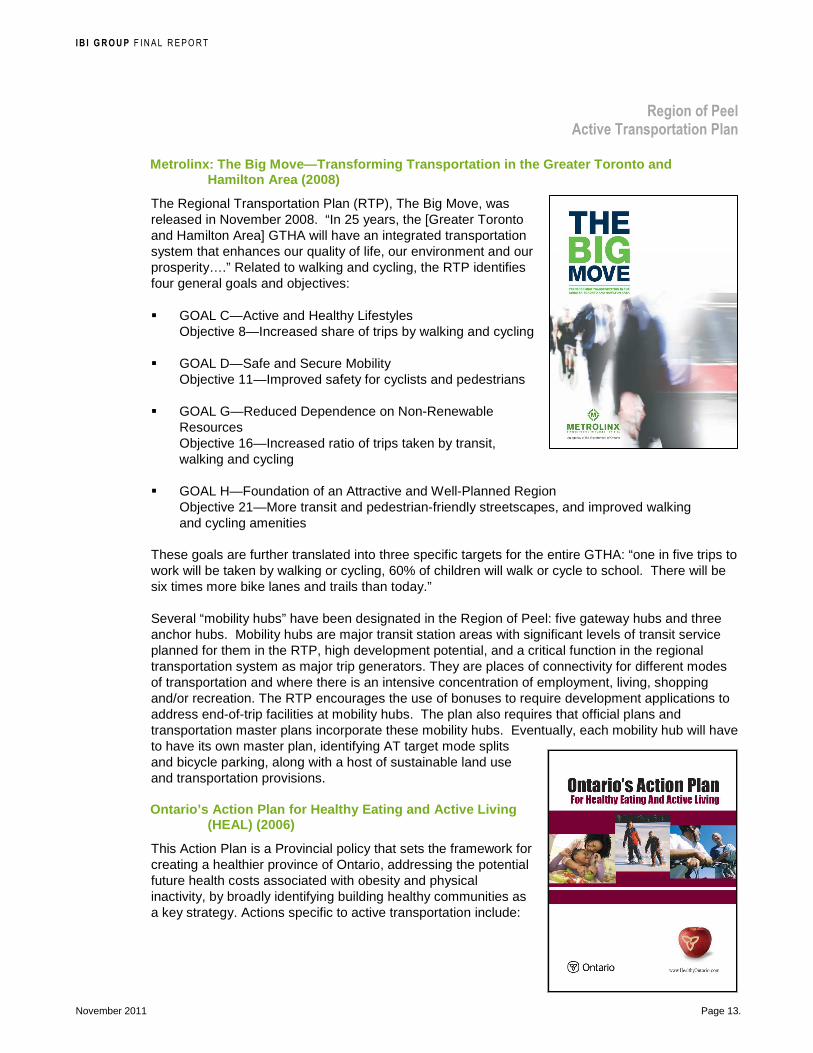
Metrolinx: The Big Move—Transforming Transportation in the Greater Toronto and Hamilton Area (2008)
The Regional Transportation Plan (RTP), The Big Move, was released in November 2008. “In 25 years, the [Greater Toronto and Hamilton Area] GTHA will have an integrated transportation system that enhances our quality of life, our environment and our prosperity….” Related to walking and cycling, the RTP identifies four general goals and objectives:
� GOAL C—Active and Healthy Lifestyles Objective 8—Increased share of trips by walking and cycling
� GOAL D—Safe and Secure Mobility Objective 11—Improved safety for cyclists and pedestrians
� GOAL G—Reduced Dependence on Non-Renewable Resources Objective 16—Increased ratio of trips taken by transit, walking and cycling
� GOAL H—Foundation of an Attractive and Well-Planned Region Objective 21—More transit and pedestrian-friendly streetscapes, and improved walking and cycling amenities
These goals are further translated into three specific targets for the entire GTHA: “one in five trips to work will be taken by walking or cycling, 60% of children will walk or cycle to school. There will be six times more bike lanes and trails than today.”
Several “mobility hubs” have been designated in the Region of Peel: five gateway hubs and three anchor hubs. Mobility hubs are major transit station areas with significant levels of transit service planned for them in the RTP, high development potential, and a critical function in the regional transportation system as major trip generators. They are places of connectivity for different modes of transportation and where there is an intensive concentration of employment, living, shopping and/or recreation. The RTP encourages the use of bonuses to require development applications to address end-of-trip facilities at mobility hubs. The plan also requires that official plans and transportation master plans incorporate these mobility hubs. Eventually, each mobility hub will have to have its own master plan, identifying AT target mode splits and bicycle parking, along with a host of sustainable land use and transportation provisions.
Ontario’s Action Plan for Healthy Eating and Active Living (HEAL) (2006)
This Action Plan is a Provincial policy that sets the framework for creating a healthier province of Ontario, addressing the potential future health costs associated with obesity and physical inactivity, by broadly identifying building healthy communities as a key strategy. Actions specific to active transportation include:
I B I G R O U P F INAL REPORT
Region of Peel Active Transportation Plan
November 2011 Page 14.
� Funding for Active and Safe Routes to School and Communities in Action (grants for physical activity, spot and healthy living projects reaching at-risk children and youth).
� Promoting healthy urban design through partnerships, supporting related provincial policies e.g., Growth Plan, hosting a series of active transportation and urban design for community planners, engineers, designers to share best practices on how to implement healthy urban design.
� Building partnerships to influence public policies that support healthy eating and active living in key settings, including workplace wellness, school health, and active transportation and enabling communities.
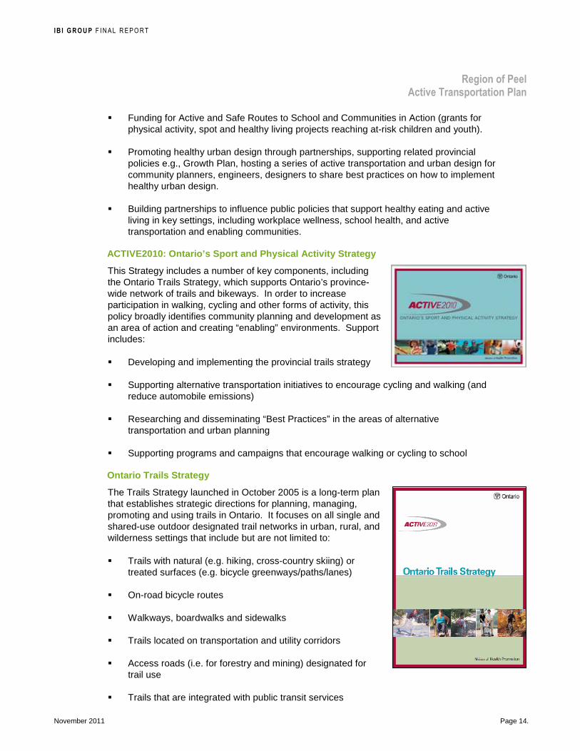
ACTIVE2010: Ontario’s Sport and Physical Activity S trategy
This Strategy includes a number of key components, including the Ontario Trails Strategy, which supports Ontario’s province-wide network of trails and bikeways. In order to increase participation in walking, cycling and other forms of activity, this policy broadly identifies community planning and development as an area of action and creating “enabling” environments. Support includes:
� Developing and implementing the provincial trails strategy
� Supporting alternative transportation initiatives to encourage cycling and walking (and reduce automobile emissions)
� Researching and disseminating “Best Practices” in the areas of alternative transportation and urban planning
� Supporting programs and campaigns that encourage walking or cycling to school
Ontario Trails Strategy
The Trails Strategy launched in October 2005 is a long-term plan that establishes strategic directions for planning, managing, promoting and using trails in Ontario. It focuses on all single and shared-use outdoor designated trail networks in urban, rural, and wilderness settings that include but are not limited to:
� Trails with natural (e.g. hiking, cross-country skiing) or treated surfaces (e.g. bicycle greenways/paths/lanes)
� On-road bicycle routes
� Walkways, boardwalks and sidewalks
� Trails located on transportation and utility corridors
� Access roads (i.e. for forestry and mining) designated for trail use
� Trails that are integrated with public transit services

I B I G R O U P F INAL REPORT
Region of Peel Active Transportation Plan
November 2011 Page 15.
� Waterway routes (e.g. along designated Canadian heritage rivers including the French, Humber, Mattawa, Rideau and Thames Rivers) and portage routes. The Humber River traverses the region.
2.2.3 Region of Peel Policies Peel Strategic Plan for 2011-2014
The Region of Peel’s Strategic Plan charts the long-term vision for the communities of Peel, and the Region’s role in achieving that vision. It is the cornerstone of strategic planning. The vision articulated in the Strategic Plan (2011-2014) is “Peel is a safe, healthy, prosperous, sustainable and inclusive community that protects the quality of life.” Active Transportation relates to the following key goals and strategic actions in the Region of Peel’s Strategic Plan 2011-2014:
• to protect, enhance and restore the environment by improving air quality, mitigate and adapt to climate change;
• to support and influence sustainable transportation systems by supporting an improved and integrated active transportation, transit and land use systems to effectively move people and goods throughout Peel;
• to maintain and improve the health of Peel’s community by influence healthy living through community design; and
• to strive for continued excellence as a municipal government by strengthening coordination between area municipalities and the Region, as well as other levels of government and community partners.
Charting our Course: Term of Council Priorities documents the areas of focus developed by Council to advance the Strategic Plan. It includes the priorities listed in Exhibit 1 that are related to active transportation.
Exhibit 1: Term of Council Areas of Focus that are Related to Active Transportation
Priority Outcome Actions 2011 Actions 2012-2014
Reduce greenhouse gas emissions
Protect the community by managing the negative impacts associated with climate change
Develop and adopt the Climate Change Strategy Confirm short and long-term targets for the reduction in greenhouse gas emissions
Implement the Climate Change Strategy Develop a greenhouse gas monitoring program following implementation of the strategy to track progress on achieving targeted emission reductions
Increase active transportation
Reduce the proportion of trips generated by cars, thereby reducing greenhouse gas emissions and improving citizens’ health
Develop Peel’s Active Transportation Plan
Implement the endorsed plan

I B I G R O U P F INAL REPORT
Region of Peel Active Transportation Plan
November 2011 Page 16.
Priority Outcome Actions 2011 Actions 2012-2014
Promote a supportive environment for healthy weights
Conduct a literature review to identify key priority areas for action Complete policy work related to the built environment Produce a discussion document on policy interventions
Increase the walkability of Peel as a result of two new policy changes adopted into urban and regional planning processes
The Region of Peel Official Plan and Region Officia l Plan Amendment 22
In 2007, the Region undertook an Official Plan Review to ensure conformity with the Growth Plan for the Greater Golden Horseshoe and the Provincial Policy Statement. Many sections and subsections of the Official Plan (OP) directly support walking and cycling through transportation and land-use planning, municipal partnerships, energy conservation and performance measurement. Regional Official Plan Amendment 22 (ROPA 22) adopted on November 19, 2009 provides new and updated transportation policies. Policies on active transportation were added to the OP through ROPA 22 and include the following:
5.9.10 Active Transportation
The promotion of active transportation and the provision of infrastructure dedicated to it are core transportation demand management strategies. Multi-purpose trails and bicycle lanes are provided by the City of Brampton, the Town of Caledon, the City of Mississauga and the Region and efforts are underway to expand the network of active transportation routes.
Active transportation offers an alternative to trips made by automobile, especially for trips covering short distances. Active transportation, in the form of walking, is a component of most trips made using transit. Increased reliance on active transportation, by itself or in combination with other sustainable modes, would therefore help reduce the strain on the transportation system. In addition, increasing the share of trips made by active transportation would help increase the sustainability of the transportation system, reduce transportation-related pollutant emissions, provide health benefits and increase peoples’ connection to their communities.
5.9.10.1 Objectives
5.9.10.1.1 To increase the share of trips made using active transportation.
5.9.10.1.2 To work towards the development of a complete, safe and integrated network of bicycle and pedestrian facilities that enhances the quality of life, and promotes the improved health, of Peel residents.

I B I G R O U P F INAL REPORT
Region of Peel Active Transportation Plan
November 2011 Page 17.
5.9.10.2 Policies
It is the policy of Regional Council to:
5.9.10.2.1 Work with Metrolinx, the area municipalities and adjacent municipalities to integrate pedestrian and bicycle networks into transportation planning to:
a) Provide safe, comfortable travel for pedestrians and bicyclists within existing communities and new development; and
b) Provide linkages between intensification areas, adjacent neighbourhoods and transit stations.
5.9.10.2.2 Work with Metrolinx, the area municipalities, adjacent municipalities and the private sector to develop and implement an Active Transportation Plan for Peel that builds on area municipal pedestrian and cycling plans.
5.9.10.2.3 Support the use of Regional roads and other Regional land as part of a safe and efficient multi-purpose trail network.
5.9.10.2.4 Encourage the area municipalities to promote land uses which foster and support the use of active transportation.
5.9.10.2.5 Work with the area municipalities to develop performance indicators for the implementation and usage of active transportation and use these indicators to monitor the impact and effectiveness of the active transportation plan.
5.9.10.2.6 Work with school boards and the private sector to promote the use of active transportation by students and to support the Peel Safe and Active Routes to School program.
5.9.10.2.7 Encourage school boards to select school site locations, define catchment areas and design school campuses to maximize walking and bicycling as the primary means of travel to school.
Staying Ahead of the Curve: The Public Health 10-Ye ar Strategic Plan
The mission of Peel Public Health is to protect and promote health, prevent disease, and reduce health disparities through a population health approach. The 10-year strategic plan sets out service delivery and internal initiatives to adopt the “Public Health Way” of doing business. The strategy will be delivered by developing the Peel Public Health workforce, making evidence-informed decisions, measuring performance and enhancing external / internal communications. One of the four program priorities is “supportive environments, healthy weights” preventing and reducing obesity among Peel residents. The effect of the built environment will be considered in the anti-obesity strategy.

I B I G R O U P F INAL REPORT
Region of Peel Active Transportation Plan
November 2011 Page 18.
2.2.4 City of Mississauga Policies Official Plan Mississauga (2010)
Mississauga Official Plan (the new official plan) was adopted by City Council on September 29, 2010. This new plan will provide the appropriate direction for Mississauga's next growth stage—redevelopment and intensification. In Section 8: Create a Multi-Modal City, the City recognizes that:
While vehicle trips will continue to account for a significant share of the total trips, the length of these trips should shorten in response to the creation of mixed use nodes that support the daily needs of surrounding residential and business communities and the share of auto trips will be reduced as opportunities to travel by transit, cycling and walking improve.
Policies on active transportation are as follows:
8.2.4 Cycling and Active Transportation Network
The City will continue to develop an integrated cycling network, to make cycling a more viable choice for commuting. Decisions regarding the location of cycling facilities will be guided by a Cycling Network Master Plan. When the Master Plan is complete, the policies of this Plan will be updated.
Active transportation facilities will address the needs of individuals with disabilities, including those who require mobility assisted devices such as, walkers, wheelchairs and scooters.
To encourage active transportation and support the development of healthy communities, the City will promote pedestrian activity as an integral part of the multi-modal transportation network.
Cycling facilities are shown on Schedule 7: Long Term Cycling Network.
8.2.4.1 Bicycle racks and bicycle storage facilities will be provided at transit terminals.
8.2.4.2 Cycling facilities will be encouraged on arterials, major collectors and minor collectors, where appropriate.
8.2.4.3 The City will construct cycling facilities to, from and within Intensification Areas as a priority.
8.2.4.4 Proponents of development applications, within Intensification Areas, will be required to demonstrate how pedestrian and cycling needs have been addressed.
8.2.4.5 Mississauga will require that access, and parking facilities and other destination amenities, such as shower facilities and clothing lockers for cyclists, are incorporated into the design of all buildings and Major Transit Station Areas, as appropriate.

I B I G R O U P F INAL REPORT
Region of Peel Active Transportation Plan
November 2011 Page 19.
8.2.4.6 Sidewalks will be provided on all new roads.
8.2.4.7 Sidewalks in the vicinity of all transit stops will be provided.
8.2.4.8 Sidewalks and pedestrian amenities will be a priority in Intensification Areas.
8.2.4.9 Mississauga will provide pedestrian connections to Intensification Areas.
Mississauga Cycling Master Plan (2010)
The Mississauga Cycling Master Plan approved in September 2010 provides strategic, design and operational direction for establishing cycling as a regular part of life in the City of Mississauga as well as integral to tourism and its economy over the next 20 years, to be updated approximately every 5 years. The objective of the plan is for “cycling to become a way of life in the City of Mississauga that supports vibrant, safe and connected communities. Mississauga will be a place where people choose to cycle for recreation, fitness and daily transportation needs enhancing our overall health and quality of life.” The goals are as follows:
GOAL 1: Foster a culture where cycling is an everyday activity
GOAL 2: Build an integrated on-road and off-road cycling network as part of a multi-modal transportation system
GOAL 3: Adopt a “safety first” approach for cycling in Mississauga
2.2.5 City of Brampton Policies 2006 Official Plan
The City of Brampton’s current Official Plan was adopted in 2006 and approved by the Ontario Municipal Board (OMB) in 2008. The broad objectives for developing the transportation system policies include:
a) To develop a balanced, integrated and accessible multi-modal transportation system which provides for the safe, economic and efficient movement of people, including persons with disabilities, as well as goods and services.
b) To ensure the provision of adequate and accessible road, transit, pedestrian and bicycle links between Brampton and adjacent municipalities.
Active transportation policies are set out in the OP policies on the pathways systems as follows:

I B I G R O U P F INAL REPORT
Region of Peel Active Transportation Plan
November 2011 Page 20.
4.4.6 PATHWAYS SYSTEM
Objectives
a) To provide a city-wide pathway system that will safely and efficiently accommodate both recreational, journey to work and cyclist/pedestrian trips;
b) To promote the use of the bicycle for purposes other than recreation and specifically for the journey-to-work, shopping, and entertainment trips;
c) To encourage walking as a healthy, environmentally friendly and as a preferred mode of travel for short trips;
d) To ensure safe and convenient movement of pedestrians including those with disabilities throughout the city; and,
e) To develop a beautiful and informative trails system that promotes the Brampton Flower City concept.
Policies—General
4.4.6.1 The Pathways System is a vital component of the City’s Open Space infrastructure and Transportation System. The recommended citywide pathways network is shown as Schedule “C1”.
4.4.6.2 Through the Community Block Plan process, the City shall seek to incorporate a pathway system with the following principles:
(i) When not accommodated along primary streets, multi-use pathways should be designed to protect the natural heritage system features, functions and linkages and open space links;
(ii) In general, multi-use pathways should be sited to avoid sensitive natural features including wetlands, streams, etc; however if located in low-lying and flood prone areas,, bridges, culverts and swales and raised walkways will be implemented as support systems that will address pedestrian safety and environmental protection;
(iii) Multi-use pathway connections should be provided through and to residential areas to facilitate accessibility and promote visibility and safety; and,
(iv) Multi-use pathways should be linked to key destinations and accessible parking areas.
4.4.6.3 Through the community block plan process, the City shall seek to incorporate a pathway system with the following principles:
(i) Link the trail system with sidewalks;
(ii) Incorporate the trail system with components of the recreational open space system;
(iii) Site and link the trail system with the street network
I B I G R O U P F INAL REPORT
Region of Peel Active Transportation Plan
November 2011 Page 21.
(iv) Incorporate signage which identifies the designated bicycle route; and points of interest,
(v) Require the construction of pathway systems in new areas as a condition of subdivision approval where appropriate.
4.4.6.4 The development of pathway systems will be provided for by:
(i) Implementing, monitoring and updating the Pathways Master Plan on a regular basis;
(ii) Providing approved ROW widths that facilitate pathway development for incorporation into subdivision design;
(iii) Providing for the development and maintenance of pathway facilities under the City’s Capital Budget Program;
(iv) Ensuring that the design of pathways complement and connect with the City’s open space infrastructure, key destinations and transit stations where feasible; and,
(v) Ensuring that all new development proposals and infrastructure undertakings include: extensions and improvements to pathways as part of the early stages of construction, wherever appropriate.
4.4.6.5 Where it is not possible due to environmental sensitivity or physical constraints to construct a pathway through a valley or watercourse corridor, the City may require land above the top of valley bank to provide continuous safe and convenient pedestrian or bicycle movement along a valley. These lands will not generally be credited as parkland dedication collected in accordance with the Planning Act.
4.4.6.6 Where appropriate the City may require additional ROW as a condition of approval for the plan of subdivision to accommodate pathways system.
4.4.6.7 The City shall endeavour to design the pathways to be continuous, safe, attractively landscaped and accessible to all members of the community including persons with disabilities.
4.4.6.8 The City shall, in the secondary planning process, ensure the provision of wider curb lanes or other types of special shoulder lanes or dedicated cycling lanes on most arterial, minor collectors and parkway roads.
4.4.6.9 The City shall provide signage that indicates the beginning and end of pathways and provides directional information and warnings at all turns and intersections.
4.4.6.10 The City shall periodically monitor the implementation feasibility and update the Pathways Report in conjunction with the applicable secondary plans.
4.4.6.11 The City shall coordinate the interconnections of major pathways with the Region of Peel and adjacent municipalities as appropriate.

I B I G R O U P F INAL REPORT
Region of Peel Active Transportation Plan
November 2011 Page 22.
4.4.6.12 The City shall provide publicity for future cycling events within the Region and shall sponsor annual awareness programs, which promote safe and responsible cycling.
4.4.6.13 The City shall encourage developers and employers to include secure bicycle parking at transit transfer stations and employment nodes.
4.4.6.14 The City shall encourage the commercial and business communities to provide facilities that promote cycling as a transportation form.
4.4.6.15 The City shall consider the provision of multi-use pathways for all urban road segments to improve safety, convenience and accessibility for pedestrians including persons with disabilities.
4.4.6.16 The City shall, in reviewing subdivision plans, ensure that pathways are designed in such a manner so as to reduce the walking distance from dwelling units to transit, park, school and convenience commercial facilities; and between residential neighbourhoods, particularly when it is not feasible or appropriate to provide sufficient connections by means of local or collector roads.
4.4.6.17 The City shall require, where appropriate and feasible, the provision of traffic control signals or pedestrian grade separations at points in the transportation system where the exposure of pedestrians to vehicles or trains is considered to be hazardous or where a direct connection would significantly reduce pedestrian trip lengths.
4.4.6.18 The City shall ensure that all new pathways be ramped at intersections where safe and practical.
4.4.6.19 The City shall ensure that “Pathways Master Plan” is implemented in accordance with Schedule “C1”. The pathways connect across appropriate concerned neighbouring municipal jurisdictions.
4.4.6.20 The City shall work with private developers, adjacent municipalities, and other appropriate jurisdictions to develop and expand facilities for pathways.
4.4.6.21 The City shall formulate programs for the successful implementation, monitoring and maintenance of the pathway facilities in accordance with the Plan.
4.4.6.22 The City shall consider opportunities for the installation of pathway features and supportive facilities as a part of residential, commercial and industrial developments.
4.4.6.23 The City shall endeavour to minimize the risk to pedestrians, cyclists and motorists including persons with disabilities through the appropriate design of pathways facilities, through the provision of signage and support for educational activities and programs.
4.4.6.24 The City shall ensure that all public pedestrian and cycling trails are designed and provided in accordance with the City of Brampton Accessibility Technical Standards and encourage the application of the standards to all other trails.
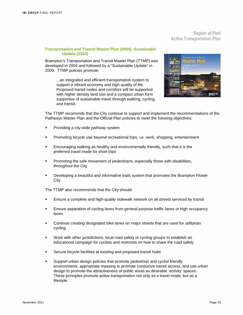
I B I G R O U P F INAL REPORT
Region of Peel Active Transportation Plan
November 2011 Page 23.
Transportation and Transit Master Plan (2004), Sust ainable Update (2010)
Brampton’s Transportation and Transit Master Plan (TTMP) was developed in 2004 and followed by a “Sustainable Update” in 2009. TTMP policies promote:
...an integrated and efficient transportation system to support a vibrant economy and high quality of life. Proposed transit nodes and corridors will be supported with higher density land use and a compact urban form supportive of sustainable travel through walking, cycling, and transit.
The TTMP recomends that the City continue to support and implement the recommendations of the Pathways Master Plan and the Official Plan policies to meet the folowing objectives:
� Providing a city-wide pathway system
� Promoting bicycle use beyond recreational trips, i.e. work, shopping, entertainment
� Encouraging walking as healthy and environmentally friendly, such that it is the preferred travel mode for short trips
� Promoting the safe movement of pedestrians, especially those with disabilities, throughout the City
� Developing a beautiful and informative trails system that promotes the Brampton Flower City
The TTMP also recommends that the City should:
� Ensure a complete and high-quality sidewalk network on all streets serviced by transit
� Ensure separation of cycling lanes from general purpose traffic lanes or high occupancy lanes
� Continue creating designated bike lanes on major streets that are used for utilitarian cycling
� Work with other jurisdictions, local road safety or cycling groups to establish an educational campaign for cyclists and motorists on how to share the road safely
� Secure bicycle facilities at existing and proposed transit hubs
� Support urban design policies that promote pedestrian and cyclist friendly environments, appropriate massing to promote conducive transit access, and use urban design to promote the attractiveness of public areas as desirable ‘activity’ spaces. These principles promote active transportation not only as a travel mode, but as a lifestyle.

I B I G R O U P F INAL REPORT
Region of Peel Active Transportation Plan
November 2011 Page 24.
Brampton’s Pathways Master Plan (2002)
The City of Brampton’s PathWays Master Plan approved in 2002 outlines core objectives and strategic actions along with guidelines to assist the City in the development and maintenance of the pathways system The PathWays system is an important component of the city's open space infrastructure, knitting parks and valleys together and providing convenient pedestrian and cycling routes across Brampton. The objectives are to promote the expansion of the system beyond recreational trails and advocate for a heightened “design” of the trail system. Three primary campaigns are:
1. Customer Driven PathWays must reflect and respond to residents' needs and desires, promoting use and encouraging a wider user base
2. Beautiful PathWays must celebrate the City's history and define its character
3. Valued PathWays to become a "living" asset must engender a sense of pride and ownership within Brampton
It should be noted that the City is updating the Pathway network and may expand it in the future to include more on-road bikeways, under the recently initiated City Bicycle Facilities Implementation Plan.
2.2.6 Town of Caledon Policies Community-Based Strategic Plan (2010)
The Town of Caledon Community-Based Strategic Plan adopted in 2010 is a document that outlines Caledon’s vision, goals and strategic objectives, and an implementation plan for the next 10 years into the future. The stated vision in the Strategic Plan is:
Caledon - a safe, green community of communities; desiring a sustainable future by managing and fostering community progress while respecting its heritage.
The vision is supported with six goals and strategic objectives. The goals and strategic objectives focus in areas of protecting and enhancing air quality, accessibility, connecting neighbourhoods, and promoting active, healthy living.
Official Plan (2008 Consolidation)
The Town’s strategic direction as outlined in ther Official Plan is as follows:
Stewardship of Resources: Protect land resources including landscape features, systems and areas that perform important natural functions or which provide economic and recreational opportunities. Included in this category are natural and cultural heritage resources, recreational lands and agricultural lands.

I B I G R O U P F INAL REPORT
Region of Peel Active Transportation Plan
November 2011 Page 25.
Settlement Patterns: A hierarchy of settlement areas will be maintained as the focus for future growth, and growth will be managed so that the majority of new residential and employment development will be concentrated in the Rural Service Centre settlements of Mayfield West, Bolton and Caledon East.
Managing Growth: The Town will manage the rate of growth and the sequencing of development in a manner that is consistent with the Principles of this Plan and the need for fiscal responsibility.
With respect to transportation, the goal is to “plan and support a transport system that provides for both inter and intra Town traffic movements, balances demand with capacity, protects and stewards ecosystems, and protects heritage sites and sensitive human environments.”
The Open Space and Recreation section of the Official Plan has objectives related to the provision of trails:
5.8.2.2. To preserve and protect existing linear trail systems, including the Bruce Trail, the Great Pine Ridge Trail and the Caledon Trailway;
5.8.2.3. To identify and develop a comprehensive recreational system in the Town through the preparation and implementation of a Caledon Greenways Strategy; and
5.8.2.4 To participate in, and support, where appropriate, the initiatives of other agencies and interest groups in establishing or expanding interconnected linear and other recreational open space systems within Caledon, and at a broader scale.
The Transportation objectives of the OP include supporting “the planning and development of pedestrian and bicycle facilities and their linkages with open space areas”. The OP includes Bicycle Routes and Pedestrian Paths policies:
5.9.11.1 The Town will encourage the development of a system of bicycle routes and pedestrian paths to link major public open space, activity centres, and the transportation network. Consideration will be given to bikeway/walkway paths as part of the transportation system in the implementation of the Parks and Recreation Master Plan. Consideration will be given in all new subdivisions, and development proposals to provisions for bikeway/walkway links with transportation networks.
5.9.11.2 The Town will ensure that there is adequate pedestrian access to existing and future school sites.
Official Plan Amendment 226
OPA 226, adopted by Town Council in June 2010, amends the Town’s Official Plan to conform with the Provincial Policy Statement, Places to Grow, and the Green Belt Plan.
The section on Sustainability specifically recognizes the importance of planning for communities for pedestrians and cyclists:
3.1.3.7 Sustainable Development Patterns and Community Design—The creation of a complete community requires developments that provide alternative forms of transportation, provide linkages that facilitate access by pedestrians and cyclists to

I B I G R O U P F INAL REPORT
Region of Peel Active Transportation Plan
November 2011 Page 26.
residential, employment and recreational areas, and provide public spaces that are safe and accessible to all including people with disabilities.
Under Growth Management, the Official Plan is amended to include:
4.2.1.2.1 To achieve compact and efficient urban forms, optimize the use of existing infrastructure and services, revitalize and or enhance developed areas, increase the availability and diversity of housing and business opportunities, and create mixed-use, transit-supportive, pedestrian-friendly urban environments through intensification.
The Transportation System Principles have been updated to include:
5.9.2 a) Adopt a multi-modal transportation system approach that offers safe convenient and efficient movement of goods, services and people including persons with disabilities;
5.9.2 b) Provide for an adequate network of roads, highways, transit, pedestrian, bicycle and rail links between Caledon and adjacent municipalities
A specific section on Active Transportation is added to the Official Plan:
5.9.5.9 Active transportation is any form of self-propelled transportation that uses human energy such as walking and bicycling. Active transportation offers an alternative to trips made by automobile especially for trips covering short distances. Increased reliance on active transportation by itself or in combination with other sustainable modes would not only help reduce the strain on the transportation system but will have immense individual, societal, environmental and economic benefits An increased share of trips made by active transportation would contribute towards the sustainability of the transportation system reduce transportation related pollutant emissions, provide health benefits and increase peoples connection to their communities.
5.9.5.9.1 The Town will encourage the development of a system of bicycle and pedestrian facilities to link major public open spaces, activity centres and the transportation network in a manner that enhances the quality of life for residents, businesses and visitor.
5.9.5.9.2 Consideration will be given to multi-use paths as part of the transportation system in the implementation of the Parks and Recreation Master Plan.
5.9.5.9.3 Consideration will be given in all new subdivision and development proposals to provisions for multi-use links with transportation networks.
5.9.5.9.4 The Town will work with the Region and school boards to promote the use of active transportation by students and to support the safe and active routes to school sites.
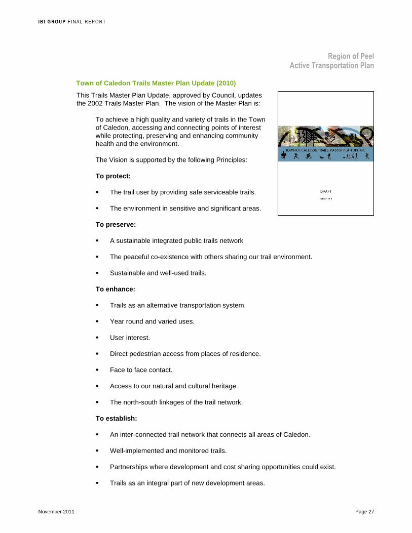
I B I G R O U P F INAL REPORT
Region of Peel Active Transportation Plan
November 2011 Page 27.
Town of Caledon Trails Master Plan Update (2010)
This Trails Master Plan Update, approved by Council, updates the 2002 Trails Master Plan. The vision of the Master Plan is:
To achieve a high quality and variety of trails in the Town of Caledon, accessing and connecting points of interest while protecting, preserving and enhancing community health and the environment.
The Vision is supported by the following Principles:
To protect:
� The trail user by providing safe serviceable trails.
� The environment in sensitive and significant areas.
To preserve:
� A sustainable integrated public trails network
� The peaceful co-existence with others sharing our trail environment.
� Sustainable and well-used trails.
To enhance:
� Trails as an alternative transportation system.
� Year round and varied uses.
� User interest.
� Direct pedestrian access from places of residence.
� Face to face contact.
� Access to our natural and cultural heritage.
� The north-south linkages of the trail network.
To establish:
� An inter-connected trail network that connects all areas of Caledon.
� Well-implemented and monitored trails.
� Partnerships where development and cost sharing opportunities could exist.
� Trails as an integral part of new development areas.

I B I G R O U P F INAL REPORT
Region of Peel Active Transportation Plan
November 2011 Page 28.
� Strong links to trails provided by others within Caledon as well as, to surrounding municipalities, regional, provincial and national trail networks.
International Charter for Walking
The International Charter for Walking was originally developed through the Walk 21 organization. It broadly recognizes the benefits of walking and identifies the following principles to help create a culture where people choose to walk:
1. Increased inclusive mobility
2. Well designed and managed spaces and places for people
3. Improved integration of networks
4. Supportive land-use and spatial planning
5. Reduced road danger
6. Less crime and fear of crime
7. More supportive authorities
8. A culture of walking
This International Charter for Walking was signed by Caledon Council in 2007.
2.3 Summary of Strategic Direction and Policy Support
Active transportation is part of Canadian national strategies in public health and activity levels, pollution reduction, and sustainable communities. Canada does not have a national active transportation strategy, however, walking and cycling clearly fit within the federal government’s vision of “a safe and secure, efficient and environmentally responsible transportation system.”
The Province of Ontario recognizes the benefits of walking and cycling to building and maintaining strong communities, a clean and healthy environment and a strong economy. Sustainable modes of transportation – transit, walking and cycling – are integral drivers and outcomes identified at the Provincial policy level. Active transportation objectives are woven into policies, strategies and actions in Provincial land-use, health and mobility plans.
In 2002, both Brampton and Caledon developed trail master plans recognizing the importance of trail activities on community health and liveability. Through subsequent updates, along with Mississauga’s newly approved cycling master plan, and official plan reviews and amendments to conform to the Provincial Policy Statement, all three local municipalities have strengthened their visions for active transportation as an important mode in their land-use / transportation responsibilities. Active transportation has clearly been identified as mode that can integrate well with public transit, as supported by Metrolinx and GO Transit, Brampton Transit, and Mississauga Transit.

I B I G R O U P F INAL REPORT
Region of Peel Active Transportation Plan
November 2011 Page 29.
There is direction and support nationally, provincially and from area municipalities for the Region of Peel to prepare a planning document outlining their roles and responsibilities for active transportation. More people walking and cycling in the Region of Peel will be a direct indicator of success in attaining their strategic directions intended to improve community health, social well-being and safety; ensure the efficient and sustainable use of land; and develop accessible, affordable and integrated transportation and transit systems.
The vision and justification to undertake a Region of Peel Active Transportation Plan are well-established and supported by all levels of government.
2.4 Role and Responsibility for the Region of Peel in Active Transportation
Three roles for the Region of Peel in active transp ortation have emerged in policy development, promotion and market ing, and network development, as follows:
� Policy development —The Region of Peel will continue to refine Regional official plan policies, elaborate on active transportation policies at a regional level through this Plan. The Region will also encourage policy improvement in area municipal Official Plan policies and provincial policies, and ensure the regional policies comply and strengthen policies at all levels of government.
� Promotion / marketing —The Region of Peel will continue to take the lead role to plan, fund and deliver the programs to promote active transportation (e.g. Walk and Roll Peel Initiative), working together with area municipalities, various provincial Ministries and Metrolinx to strengthen the behavioural shift programs.
� Network development – According to the Municipal Act, sidewalks are the responsibility of the lower-tier municipalities. Currently, sidewalks and multi-use trails along Regional roads are municipal assets. The maintenance and operation of such facilities is the responsibility of the lower-tier municipalities. During the planning and design phases of Regional road capital projects, the Region in consultation with area municipal staff review and incorporate local municipality pedestrian and cycling networks within the Regional road rights-of-way wherever possible and feasible.
Previously on reconstruction projects, the majority of costs to install active transportation facilities on Regional roads were borne by the area municipalities although the Region does cover design, utility, and property costs. Under the Development Charges By-law 115-2007, provisions are in place for the Region to collect for sidewalks for future road widening projects. In consultation with area municipal staff, agreements were made between the Region and the area municipalities on the type of facilities to be included and on what projects. In some cases, the funding for sidewalks has been use to include multi-use trails due to the minimum cost difference between a sidewalk and a multi-use trail. Under the 2012 Development Charges By-law update, multi-use trails
AT Plan Recommendation: Three roles for the Region of Peel in active transportation have emerged in policy development, promotion and marketing, and network development.
All of these roles are novel for the Region of Peel. Thus it is recommended that the Region of Peel continue with these responsibilities with periodic review and updating through the Active Transportation Plan review process. Similar to other master plans, the Active Transportation Plan should be reviewed every five years to determine its applicability and provide any necessary updates to the plan.
I B I G R O U P F INAL REPORT
Region of Peel Active Transportation Plan
November 2011 Page 30.
and sidewalks are proposed to be included in the update for future road widening projects.
In the past, the Region and the municipalities have also been successful in partnering in establishing trails on the Region’s easements (valley lands) such as the Etobicoke Creek Trail on the sanitary easements (Ponytrail Drive to Toronto and Eglinton Avenue to Highway 401), Applewood Trail on the watermain easements (Burnhamthorpe Road to Bloor Street), and the Culham Trail on the sanitary easements (Burnhamthorpe Road to Bloor Street).
The proposed new role for the Region of Peel in network development, through this Active Transportation Plan, is to:
– Work closely with area municipalities to plan and implement (including reviewing funding options) the active transportation facilities on Regional rights-of-way to ensure that they fill gaps in the existing network, are integrated with the planned local active transportation network, and meet Provincial accessibility guidelines / standards.
– Work closely with neighbouring municipalities to interconnect their active transportation networks and facilities along Regional roads.
– Research and develop best practices in accessible pedestrian facilities and bikeway design, such as intersection treatments (bike boxes, detection, detectable warnings, etc.), cycle tracks, maintenance procedures, signage, etc.
– Consult and coordinate with internal stakeholders (e.g. Public Works, Finance, Peel Health, Peel Police, Accessibility Committee, etc.), all levels of government (e.g. MTO, Metrolinx / GO Transit, and area and adjacent municipalities, Brampton Transit and Mississauga Transit), agencies (Toronto Region Conservation Authority and Credit Valley Conservation), external stakeholders (e.g. NGOs, cycling and trail clubs, school boards), and members of the public on regionally-led network development projects and the Region’s future updates of the active transportation plan.
– Facilitate the exchange of knowledge and information.
– Monitor and evaluate the implementation efforts.
All of the above are novel roles for Region of Peel. Thus it is recommended that the Region of Peel continue with these responsibilities with peri odic review and updating through the Active Transportation Plan review process. Similar to other master plans, the Active Transportation Plan should be reviewed every five y ears to determine its applicability and provide any necessary updates to the plan.

I B I G R O U P F INAL REPORT
Region of Peel Active Transportation Plan
November 2011 Page 31.
Lesson Learned: Active transportation success in Canada— In a survey of Transportation Association of Canada (TAC) member municipalities, respondents enthusiastically identified many upcoming initiatives and works-in-progress for active transportation. Measures of success, however, were more difficult to find. This report uncovers these relatively undocumented stories that are developing throughout Canada for successful implementation of active transportation strategies. The basic questions and lesson learned centre on the following topics:
Leadership—Successful AT programs require leaders with a sincere interest in active transportation. These leaders may emerge from municipal staff, credible local advocates, community leaders or politicians. The intangible nature of leadership makes it difficult to control, and therefore a great challenge. Leaders may be motivated by many different factors so getting them to see how active transportation is linked to benefits is key.
Partnerships—Active transportation is a multidisciplinary issue requiring a multi-disciplinary approach. Working across departments and jurisdictions can greatly accelerate progress.
Public Involvement—Involve members of the public through non-traditional approaches, target multiple stakeholders, and ensure that consultation remains focused and interesting.
Financial and human resources—Address financial and staffing resource limitations through creative solutions and strong partnerships, as well as alternative approaches to budgeting that reflect the benefits of AT.
Knowledge and skills—Build knowledge and skills through AT-specific training for staff and other stakeholders. Gain valuable understanding and experience through data collection and pilot projects.
Policy and planning—Identify and promote an understanding of the implications of land use decisions on active transportation. Opportunities to tailor decisions to better support active transportation exist at every level from overall growth management planning to detailed road design standards.
Travel facilities—Identify and pursue opportunities to provide safe, comfortable and direct facilities for walking and cycling. Opportunities can be identified through the preparation of a network master plan, but must also be carried through to design, construction, operation and maintenance processes. Existing standards and conventions need not be a barrier and can be overcome through innovation.
Road safety—Adopt practices and programs which explicitly address safety issues for pedestrians and cyclists as well as perceived concerns about weather and personal comfort.
Crime and personal security—Foster a culture of knowledge, understanding and action to overcome real and perceived concerns about personal security and bicycle theft.
Affecting a culture: attitudes and perceptions—Encourage people to try walking or cycling in different environments with the goal to make active transportation a regular daily activity for all segments of the population. Planners and other decision makers who regularly commute by active transportation are most likely to identify needs and gaps as well as understand the importance of developing facilities geared to all experience levels.
Outreach to encourage active choices—Work directly with employers, schools, community groups and households to broaden the impact and uptake of active transportation initiatives.
Active Transportation – Making it Work in Canadian Communities, Transportation Association of Canada, Ottawa, 2011.

I B I G R O U P F INAL REPORT
Region of Peel Active Transportation Plan
November 2011 Page 32
3 CONSULTATION The purpose of this section is to document the consultation process undertaken for the study. Specific recommendations or revisions based on the consultation are documented in subsequent chapters.
The Region of Peel Active Transportation Study was directed by a Steering Committee comprised of various staff from Region of Peel and the local municipalities of Brampton, Caledon and Mississauga. Their insights and recommendations were guided by consultation with other government representatives, stakeholders and members of the public through consultation events. Those events are outlined below; more detailed summaries of the consultation events are available in Appendix A along with a table summarizing all comments received. Exhibit 2 illustrates the range key stakeholders involved in the study.
Exhibit 2: Representative Stakeholders Consulted du ring the Active Transportation Study

I B I G R O U P F INAL REPORT
Region of Peel Active Transportation Plan
November 2011 Page 33.
3.1 Agency and Area Municipalities Consultation with Provincial, Regional, and local and adjacent municipalities was carried out to learn about relevant plans, policies and projects relevant to the Active Transportation Study, and solicit feedback on preliminary recommendations for an active transportation network.
The consulting team met with Region of Peel senior management during the development of the network to dialogue on current practices and direction of the Active Transportation Study. The Legal Department also provided feedback on issues such as the Municipal Act as it pertains to jurisdictional responsibilities and the signing, and pavement markings applicable to paved shoulders based on responsibilities and liabilities as per the Highway Traffic Act.
During the implementation phase of the study, the consultants obtained input from the area municipal departments responsible for funding of active transportation facilities to determine current funding sources for capital and maintenance projects.
Two agency workshops were organized during the first two phases of the study, and a presentation of the draft plan was made prior to presentation to area municipal and Regional Councils. These events are summarized below.
3.1.1 Agency Workshop No. 1 The first agency workshop was held on June 1, 2010. Invitations were sent out to approximately 30 individuals. The event was attended by 17 people representing 12 different organizations from across the Region. There were two purposes of the first agency workshop:
� Introduce the AT study to appropriate local agencies and area municipalities and describe the Region’s role, study background and main goals; and
� Hear about views, programs and policies, and to learn about best practices.
Through roundtable discussion, representatives identified their top issues, and opportunities as well as partnerships and roles that they would like to see from the study itself and from the Region of Peel. These perspectives are presented in relevant sections of this report.
3.1.2 Agency Workshop No. 2 The second agency workshop was held on October 15, 2010. Invitations were sent out to approximately 71 individuals. The event was attended by 29 people representing 12 different organizations. The purpose of the second workshop was to:
� Present the draft active transportation network; and
� Solicit feedback on the proposed network regarding potential opportunities, specific designs, missing corridors; and

I B I G R O U P F INAL REPORT
Region of Peel Active Transportation Plan
November 2011 Page 34.
� Learn from experiences in other municipalities.
Participants were each given maps of the draft active transportation network and presented with an outline of the network strategy as well as key elements to the development of the plan. A roundtable discussion resulted in the identification of several issues by the government agencies to improve the draft networks and policies. The comments were related to several key themes: promotion, education and programming; multiple jurisdictional issues; ideas from other municipalities; implementation strategies; the AT networks and design; and policy-related issues. These comments are presented in relevant sections of this report.
3.1.3 Presentation of Draft Plan A meeting was held on June 21, 2011 with Region, area municipal and Ministry of Transportation, Ontario (MTO) staff. The purpose of the meeting was to present the Region of Peel Active Transportation Study vision, findings and recommendations, and receive feedback before finalizing the report and presenting it to area municipal and Regional Councils. Twenty-nine people attended with representation from Region of Peel Development Services, Public Health, Roads Capital and Transportation, Town of Caledon, City of Brampton, City of Mississauga, and MTO.
Gayle Bursey, Director, Chronic Disease and Injury Prevention, Peel Public Health provided an introduction to the Region of Peel’s interest in the study. She had three key messages for attendees:
1. Call to action to slow the rate of increase in chronic diseases: Obesity and diabetes rates are on the rise in Peel; people are aware of the benefits of physical activity; it is the environment in which we live that present barriers to active living; and there is a need to focus on building an active transportation network that supports utilitarian uses for physical activity, getting people to where they need to go, not just a network for recreation.
2. We will be held accountable as civil servants and need to keep our eye on the ball: Small, “one-off” changes will not make the difference needed; there is a need to focus on larger, co-ordinated efforts to make a significant impact.
3. The time has come: There is public interest reflected in the media support for building sustainable and healthy communities.
Feedback from this meeting was incorporated into the final Active Transportation Plan and Implementation Strategy reports.
3.2 Stakeholders Stakeholders were non-governmental organizations whose mandates are related to seeing more people walk or bicycle. Two stakeholder workshops were conducted to seek community input from key stakeholders. Among invited groups were hiking and cycling clubs, accessibility advisory committees, school boards, environmental stewardship groups and trail heritage groups.

I B I G R O U P F INAL REPORT
Region of Peel Active Transportation Plan
November 2011 Page 35.
3.2.1 Stakeholder Workshop No. 1 The first stakeholder workshop was held on June 16, 2010. Invitations were sent to 30 individuals, and three attended while two submitted comments by email. The purpose of the first stakeholder workshop was twofold:
� Introduce the AT study, more specifically inform stakeholders of the background, policies and visions in Provincial, Regional and local related plans that support or inform the study; and
� Solicit stakeholder feedback, particularly for ideas to encourage and support active transportation.
Each participant was asked in turn to identify what they thought the Region of Peel Active Transportation Study should address leading to a draft vision for the overall study.
3.2.2 Stakeholder Workshop No. 2 The second stakeholder workshop was held on October 13, 2010. Approximately 75 stakeholders were invited to participate and 20 people attended. The purpose of the second workshop was:
� Introduce the draft AT networks; and
� Solicit feedback on the proposed network and to identify priority areas or projects.
Participants were provided with a map of the draft active transportation network, presented with information about the key elements to the development of the plan, and an outline of the network strategy for the pedestrian network and cycling network in each local municipality. Several issues were identified by the stakeholders to improve the draft AT networks. The main themes of the roundtable discussion were accessibility, different needs for different user groups, education, general network comments, maintenance issues, safety on multi-use boulevard trails and specific network connections. Feedback from this workshop was presented to agency and area municipality stakeholders during Agency Workshop No. 2, and is presented in relevant sections of this report.
3.3 Public Consultation Members of the public were invited to get involved in the Active Transportation Study through a variety of means:
� Submit comments through the Region of Peel’s www.walkandrollpeel.ca web site, including “The Lounge” or “Share Your Story” links, and via the project link with email links to the Region’s and IBI Group’s project leads;
� Write comments on boards that were provided to the local municipalities for posting in public venues; and

I B I G R O U P F INAL REPORT
Region of Peel Active Transportation Plan
November 2011 Page 36.
� Attend the two open houses.
3.3.1 Open Houses No. 1 The first of a series of two public open houses were held in June 2010, one in each of the Region’s area municipalities. In total, 13 people signed the registration sheets however many attendees did not register; more likely up to 50 people passing by the displays were introduced to the study. The purpose of this first series of open houses was to generate public interest in the study, inform them about the study scope, and discuss with attendees what improvements need to be made for pedestrians and cyclists in the Region of Peel. Displays summarized the study purpose and maps were provided on which people could write ideas for improvements for pedestrians and cyclists. Attendees were encouraged to select criteria for walkable and bicycle-friendly communities that need improvement in the Region of Peel as well as provide general comments or ideas for the AT study.
3.3.2 Open House No. 2 The second public open house was held in April 21, 2011 at Brampton City Hall. In total, 52 people signed the registration sheets. The purpose of the open house was to invite the public to review the recommendations of the Active Transportation study, ask questions, and share their ideas. Displays summarized the study purpose, roles for the Region of Peel, policy, programming and network recommendations. Maps were on display illustrating the proposed long-term regional pedestrian and cycling networks. Three presentations followed by question and answer periods were held during the open house, and a comment form was made available. Of the comment forms received, 13 people were in support of the Active Transportation Study while three people were not with specific recommendations to improve the study. Other comments centred on the topics of the pedestrian and cycling network, end-of-trip facilities, programs, safety, development, maintenance and funding.

I B I G R O U P F INAL REPORT
Region of Peel Active Transportation Plan
November 2011 Page 37
4 TRAVEL ATTITUDES AND PATTERNS
Data and information from the following three surveys were reviewed with respect to travel patterns, destinations of trips, and potential for active transportation:
� Transportation Tomorrow Survey (2006) by University of Toronto Data Management Group supported by the Province and regions in southern Ontario
� Smart Commute Association: Commuter Attitudes Survey 2006—Peel Region Results (Decima Research, April, 2007)
� Peel Region’s Communication and Social Marketing Strategy Phase 1 commuter attitudes survey
4.1 Existing Travel Patterns and Attitudes
4.1.1 Active Transportation Modal Share According to the 2006 Transportation Tomorrow Survey on work and school trips, the Region’s cycling mode share is quite low with only 0.3 percent of all trips made by bike, as illustrated in Exhibit 3. Walking levels are also low at 4.9 percent, but an order of magnitude higher than cycling and on par with other adjacent municipalities. With Caledon being a relatively rural community with limited sidewalks and cycling facilities, residents walk significantly less than in Brampton or Mississauga.
4.1.2 Destination of Trips The origin and destinations of work and school trips that either begin or end in the Region of Peel are illustrated in Exhibit 4. There is a considerable diversity of land uses within the Region of Peel and it is not necessarily the bedroom community that many imagine it to be. Considering all trip origins and destinations, 72% are contained within the Region of Peel. Of all trips within the Region of Peel in 2006, 34% required crossing at least one major freeway.3 These freeways pose significant barriers to active transportation.
3 Trips to/from/within Peel Region. Transportation Tomorrow Survey (2006) - trip purposes for walking and cycling are only work and school.

I B I G R O U P F INAL REPORT
Region of Peel Active Transportation Plan
November 2011 Page 38.
Exhibit 3: Modal Share in the Region of Peel and Ad jacent Municipalities (2006) 4
Exhibit 4: Region of Peel Trip Origins and Destinat ions (2006) 5
4 Trips to/from/within Peel Region. Transportation Tomorrow Survey (2006) - trip purposes for walking and cycling are only work and school. 5 All trips to/from Peel Region to/from the region indicated. Transportation Tomorrow Survey (2006) - trip purposes for walking and cycling are only work and school.
I B I G R O U P F INAL REPORT
Region of Peel Active Transportation Plan
November 2011 Page 39.
4.1.3 Commuter Attitudes A recent report prepared for Smart Commute, the Region of Peel sheds further light on the Region’s travel behaviour and attitudes towards cycling and walking. Some of the report highlights with respect to walking and cycling are presented below: 6
� Average one-way commute time is 34 minutes
� Caledon residents are more likely than Mississauga and Brampton residents to commute by driving alone. Nearly all (95%) Caledon residents primarily commute by car and only recently has there been limited transit service.7
� Among those who primarily use public transit, 60% walk to the transit stop.
� The majority (76%) of commuters who primarily use public transit or bicycle don’t bring their bike with them on public transit.
� Six percent of commuters use non-motorized methods to get to work, school or their volunteer commitments.
� For commuters who travel by a non-motorized means (walk, jog, in-line skate, wheelchair, scooter), the average time acceptable for a regular commute is 26 minutes (~2 km walk).
� 2% of commuters cycle to get to work, school or their volunteer commitments.
� Among commuters who cycle or would ideally cycle, the maximum acceptable trip time in minutes is 37 minutes. This is 14 minutes higher than their actual average commute time of 23 minutes.
� Over half (55%) say that bike parking is extremely, very or somewhat important in their decision to commute by bike. About seven in ten (68%) say there is adequate bike parking at work, school or their volunteer commitment.
4.2 Potential for Active Transportation
4.2.1 Short Trips Even with an existing auto-oriented development patterns and transportation network, 46% of the work and school trips made in 2006 were shorter than 5 km, as illustrated in Exhibit 5, which is generally considered a reasonable distance by bicycle. In terms of each municipality, Mississauga and Brampton show a similar proportion of short trips, on par with the Regional average. Caledon has a similar number of work / school trips that are within a walking distance of 2 km, but fewer short trips 2 to 5 km in length. Being a rural community with more dispersed land uses, the potential to replace short trips in Caledon by cycling is significantly lower.
Considering only short work and school trips less than 2 km in length, more than 70% in the Region of Peel are currently taken by automobile, as illustrated in Exhibit 6. In the case of trips 2 to 5 km in
6 Decima Research (2007) Smart Commute Association: Commuter Attitudes Survey 2006: Peel Region Results. Prepared for Peel Region. 7 GO Transit now serves Bolton.

I B I G R O U P F INAL REPORT
Region of Peel Active Transportation Plan
November 2011 Page 40.
length, more than as 85% are taken by automobile. This suggests there is considerable potential to increase the amount of walking and cycling on short trips in the Region of Peel, however considerable effort is required to shift travel behaviours from driving to walking and cycling.
With such a large portion of trips contained within the Region of Peel, and a relatively high proportion of short trips, this suggests a strong potential for active transportation.
Exhibit 5: Proportion of Short Work / School Trips (All Modes) in Region of Peel and Adjacent Municipalities 8
8 Transportation Tomorrow Survey (2006)
The higher the percentage of short trips, the more
potential there is to shift trips to walking
and cycling.

I B I G R O U P F INAL REPORT
Region of Peel Active Transportation Plan
November 2011 Page 41.
Exhibit 6: Proportion of Short Work / School Trips by Automobile in Region of Peel and Adjacent Municipalities
4.2.2 Commuter Attitudes The Decima report highlighted some important issues regarding the Region of Peel commuter attitudes towards the potential for walking and cycling:9
� Commuters list traffic congestion as the top reason why transportation is an important issue.
� Eighty-one percent of Peel residents think transportation in the Greater Toronto Area (GTA) and Hamilton is an important issue.
� 22% said they would consider bringing their bicycle on public transit.
� Among those who do not see themselves switching from driving alone, most commonly it is because they feel they have few other convenient options.
9 Decima Research (2007) Smart Commute Association: Commuter Attitudes Survey 2006: Peel Region Results. Prepared for Peel Region.
The higher the percentage of short trips by automobile, the more effort
required to shift trips to walking and
cycling.

I B I G R O U P F INAL REPORT
Region of Peel Active Transportation Plan
November 2011 Page 42.
The Phase I commuter attitudes survey concludes that there are many significant challenges and a number of opportunities with respect to promoting active transportation in the Region of Peel:
Key barriers Key opportunities
� Safety concerns � Recreational trail use is relatively high � Lack of infrastructure to support walking and
biking � Increase awareness of existing trails and
encourage their use for active transportation in addition to recreation
� General lack of interest with respect to the subject of active transportation
� Help residents find riding and walking partners; they would be more active if partnered
� Perceived constraints with respect to distance and time
� Focus on youth since as they face fewer barriers with respect to time and are generally more active
Focus groups discussions and workshops conducted as a part of Phase 1 further suggested that there was:
� A lack of a integrated and complete active transportation infrastructure in the Region;
� A need to improve safety, mobilize businesses and government and better coordinate the efforts of advocacy groups across the region; and
� A need to consider legislative changes to media events to corporate challenges.
4.2.3 Target for Percent of Trips by Active Transportation Based on the 2006 Transportation Tomorrow Survey, 5% of daily work and school trips (approximately 115,000 trips) made by Peel residents were by walking or bicycling. In the next five years, as a result of the network improvements and educational / promotional programs, the Region of Peel is aiming to increase the total trips for active transportation from 5% to 7%, and double it to 10% in the longer term. These targets are estimated based on the potential short distance trips by automobile that could otherwise be travelled by walking or bicycling.
4.3 Collision Statistics The Region of Peel provided statistics for collisions occurring on Regional roads for the years 2007 to 2009 (3 years of data):
� There were 14,786 reported collisions on Regional roads of which 175 (1%) involved pedestrians, and 82 (0.5%) involved cyclists over the three-year period. Fifty-one fatalities occurred of which six (11%) were pedestrians and one (2%) was a cyclist.
� 56% of all collisions involving pedestrians and cyclists occurred in Brampton, 40% in Mississauga and 4% in Caledon.
� Most of the collisions involving pedestrians or cyclists occurred in or were related to intersections, as illustrated in Exhibit 2: 40 to 50% of the pedestrian and cycling collision

I B I G R O U P F INAL REPORT
Region of Peel Active Transportation Plan
November 2011 Page 43.
occurred in or near intersections in Brampton; 30 to 40% were related to intersections in Mississauga.
Exhibit 7: Location of Collisions on Regional Roads involving Pedestrians or Cyclists by Area Municipality (2007 to 2009)
4.4 Summary of Travel Attitudes and Patterns The travel surveys and collision statistics indicate that the Region of Peel Active Transportation Plan should take into account the following:
� Walking is already an important mode of transportation in the Region of Peel with close to 5% of the work / school trip mode share. Increasing this to 7% over the next five years, and doubling it to 10% in the longer term are reasonable targets.
� With around 15% of all trips originating in the Region of Peel destined to adjacent municipalities, connections to their active transportation infrastructure should be created.
� With 60% of all transit users walking to transit stops / stations, integrating the pedestrian infrastructure with transit is very important.
� Adequate bicycle parking at destinations is very important.
� An integrated network of pedestrian and cycling facilities within the rural communities, suburban and urban areas of the area municipalities are required to accommodate the significant number of short work and school trips that occur within the Region of Peel and address concerns about the lack of facilities and the need to improve safety.
� Based on reported collisions on Regional roads, improvements at intersections are required to address pedestrian and cyclists’ safety.

I B I G R O U P F INAL REPORT
Region of Peel Active Transportation Plan
November 2011 Page 44.
� Efforts beyond improving the active transportation infrastructure are needed to shift people out of their cars and onto their feet or bicycles.

I B I G R O U P F INAL REPORT
Region of Peel Active Transportation Plan
November 2011 Page 45
5 ACTIVE TRANSPORTATION POLICIES
The Region of Peel has clearly adopted strategic directions that align with active transportation becoming a viable transportation choice for residents of the Region. Policies adopted in the last decade express clearly the direction in which the Region intends to develop to support more and safer walking and cycling. In order to have policies affect change, the following elements are required:
� Processes or institutional structures to undertake and ensure the implementation of approved objectives and policies. These could consist, for example, of staff, working or advisory groups specifically responsible for overseeing the implementation of related policies, guidelines for the process that studies and projects follow to achieve objectives and approval;
� Updating of active transportation and transportation design concepts on a whole to reflect current knowledge, innovation, and Region of Peel context (Regional road operational characteristics, i.e., volume, mix and speed of traffic). This could be achieved, for example, during periodic updates of guiding documents, through working group discussions and staff training, or through demonstration projects. Updates will be informed by planning and design guidelines adopted by professional organizations and from other jurisdictions;
� Staff training for those responsible for planning, design, construction, operation and maintenance of Regional roads so that they are fully aware of and capable of implementing best practices in active transportation;
� Approaches to identify deficiencies and retrofit existing Regional roads with appropriate treatments to improve the quality of the walking and rolling trip;
� Strengthened and effective partnerships that focus on enhancement projects that require a collaborative approach such as freeway crossing improvements and a new pedestrian / cycling crossing of the Credit River;
� Ongoing and predictable financial commitment for implementation and maintenance; and
� Mechanisms to encourage the local municipalities in implementing active transportation infrastructure in Regional road boulevards under local jurisdiction.
Revisions to current Regional Official Plan active transportation policies, and additional supportive policies contained within this Plan are presented below.

I B I G R O U P F INAL REPORT
Region of Peel Active Transportation Plan
November 2011 Page 46.
5.1 Regional Official Plan Policies New active transportation policies were added to the Regional Official Plan through the Regional Official Plan Amendment 22 (ROPA 22). These policies were adopted by council in 2009 and approved by the Province in 2010. They are provided below. Recommendations to strengthen and align those policies to reflect the vision as developed in the Active Transportation Plan are highlighted in yellow. These will be incorporated into the Peel Region Official Plan Amendment 26 and the need for an active transportation schedule will be reviewed at the next Regional Official Plan update.
5.9.10 Active Transportation
The promotion of active transportation and the provision of infrastructure dedicated to it are core transportation demand management strategies. Multi-purpose trails and bicycle lanes are provided by the City of Brampton, the Town of Caledon, the City of Mississauga and the Region and efforts are underway to expand the network of active transportation routes.
Active transportation offers an alternative to trips made by automobile, especially for trips covering short distances. Active transportation, in the form of walking, is a component of most trips made using transit. Increased reliance on active transportation, by itself or in combination with other sustainable modes, would therefore help reduce the strain on the transportation system. In addition, increasing the share of trips made by active transportation would help increase the sustainability of the transportation system, reduce transportation-related pollutant emissions, provide health benefits and increase peoples’ connection to their communities.
5.9.10.1 Objectives
5.9.10.1.1 To increase the share of trips made using active transportation.
5.9.10.1.2 To work towards encourage and support the development of a complete, safe, attractive, accessible and integrated network of pedestrian and bicycle facilities that enhances the quality of life, and promotes the improved health of Peel residents.
5.9.10.2 Policies
It is the policy of Regional Council to:
5.9.10.2.1 Work with the Province, Metrolinx, the area municipalities and adjacent municipalities to integrate pedestrian and bicycle networks into transportation planning to:
a) Provide safer, comfortable, attractive and accessible travel for pedestrians and bicyclists where appropriate on regional facilities within existing communities and new development; and
b) Provide linkages on regional facilities between intensification areas, adjacent neighbourhoods and transit stations.
AT Plan Recommendation: Strengthen and align the active transportation policies in the Regional Official Plan Amendment 22 to reflect the vision as developed in the Active Transportation Plan. Incorporate into the Peel Region Official Plan Amendment 26 and review the need for an active transportation schedule at the next Official Plan update.
I B I G R O U P F INAL REPORT
Region of Peel Active Transportation Plan
November 2011 Page 47.
5.9.10.2.2 Work with the Province, Metrolinx, the area municipalities, adjacent municipalities and the private sector to develop and implement an Active Transportation Plan for Peel that builds on area municipal pedestrian and cycling plans.
5.9.10.2.3 Support the use of Regional roads and other Regional land as part of a safe, efficient attractive and accessible multi-purpose trail network active transportation network.
5.9.10.2.4 Encourage the area municipalities to promote land uses which foster and support the use of active transportation.
5.9.10.2.5 Work with the area municipalities to develop performance indicators for the implementation and usage of active transportation and use these indicators to monitor the impact and effectiveness of the active transportation plan.
5.9.10.2.6 Work with school boards and the private sector to promote the use of active transportation by students and to support the Peel Safe and Active Routes to School program and other new initiatives.
5.9.10.2.7 Encourage school boards to select school site locations, define catchment areas and design school campuses to maximize walking and bicycling as the primary means of travel to school.
NEW Work with all levels of government, non-governmental community groups and the private sector to increase the active transportation modal share through health promotion and educational strategies that target the needs of residents and employees in the Region of Peel.
7.7 Regional Road Widening
7.7.2.5 Require the gratuitous dedication to the Region of additional land, if needed, where an existing at-grade railway crossing of a Regional road or active transportation facility is anticipated to be grade-separated in the future.
5.2 Additional Supportive Active Transportation Plan Policies
The following recommended policies that support active transportation provide additional guidance on activities and responsibilities beyond the general Regional Official Plan Policies. They can be updated through the Active Transportation Plan review process without requiring a Regional official plan amendment. These policies are organized around four key themes: Build Knowledge and Design Strategies; Implement the AT Plan; Shift the Regional Road Character; and Create AT-friendly Developments and Communities.
AT Plan Recommendation: Endorse additional supportive policies within the Active Transportation Plan organized around four key themes: Build Knowledge and Design Strategies; Implement the AT Plan; Shift the Regional Road Character; and Create AT-friendly Developments and Communities.

I B I G R O U P F INAL REPORT
Region of Peel Active Transportation Plan
November 2011 Page 48.
5.2.1 Build Knowledge and Design Strategies Doing things differently, that is shifting focus from auto-centred transportation planning, design, operations and maintenance, requires a commitment to:
� Restructuring—creating organizational reporting and responsibilities or working groups so that those responsible for all aspects of Regional roads receive appropriate direction and guidance, and make accountable decisions on active transportation
� Rewriting—reviewing and updating all by-laws, criteria, guidelines and manuals that affect active transportation including those used to plan, design, construct, manage traffic, operate and maintain active transportation infrastructure
� Retraining—provide both broad and specific training opportunities so that staff are knowledgeable in the application of best practices for active transportation
The following policies are intended to integrate and expand the knowledge base of the relatively new and evolving field of active transportation into the responsibilities of the Region:
� Develop and improve processes to better accommodate active transportation into the Region’s decisions and responsibilities until such accommodations become routine.
� Continue the Active Transportation Leadership Working Group comprised of staff from Region of Peel Public Works and Public Health in partnership with the area municipalities.
� Allocate staff to oversee the implementation of the Active Transportation Plan (programming and network implementation). They will co-ordinate across departments in the Region of Peel, area municipalities, neighbouring municipalities, various provincial Ministries and Metrolinx, and other governments and agencies, collaborate with all stakeholders in the public, private and non-profit sectors, and communicate with the public until such time accommodation becomes routine.
� Reference and apply current and professionally supported guides for the promotion, planning, design, maintenance and operation of active transportation facilities, including any approved standards related to the Ontarians with Disabilities Act, and engineering design manuals such as MTO and TAC Guidelines, Velo Quebec’s Planning and Design for Pedestrians and Cyclists, NACTO’s Urban Bikeway Design Guide, and others as appropriate.
� Review and update Regional documents that affect the planning, design, operation and maintenance of Regional facilities to explicitly integrate active transportation facilities, with exceptions to best practices justified transparently.
� Enable opportunities to discuss and resolve design strategies that go beyond current design practices, including:
– Providing multi-use boulevard trails on both sides of Regional Roads,
– Replacing deteriorated sidewalks with multi-use boulevard trails on one or preferably both sides of Regional Roads

I B I G R O U P F INAL REPORT
Region of Peel Active Transportation Plan
November 2011 Page 49.
– Designing segregated bike lanes along Regional road intensification corridors and higher-order transit corridors
– Constructing sidewalks and bike lanes on Regional roads in rural communities
– Retrofitting bike lanes or segregated bike lanes where boulevard trails are not appropriate
Additional information on the context in which these new design strategies should be considered is provided in Section 8.5: Policy Recommendations for New Design Strategies, page 126.
5.2.2 Implement the Region of Peel Active Transportation Plan
The following policies focus on implementation of the active transportation plan:
� Establish and review funding agreements on capital and maintenance of the active transportation facilities with area municipalities.
� Implement the active transportation plan for short, medium and long term as recommended in this Active Transportation Plan, establishing partnerships with the area municipalities, MTO, Metrolinx, and other potential stakeholders to leverage funding for projects and improvements outside the Region of Peel’s Capital Road Improvement Program.
� Support local partners (e.g., area municipalities, non-profit and private sector) in local active transportation programming, such as tourism and public bike initiatives.
� Work with the local municipalities to encourage them to establish an audit process for the continual improvement of existing active transportation facilities, including addressing safety issues associated with multi-use trails located along Regional road with frequent driveways and intersections.
� Through the development of specific design strategy policies, enable the active transportation network to evolve to incorporate the latest demonstrated, beneficial initiatives as they develop in North America within a changing legislative environment, using demonstration projects and associated communication plans to inform the public about new ideas. This will allow the Region of Peel to move from implementing conventional facilities to higher-order (more comfortable, safer and efficient) facilities.
� Require the gratuitous dedication to the Region of additional land beyond Schedule F, if needed and where feasible, where an active transportation facility is planned in the future road widening, resurfacing or reconstruction improvements. The need for an active transportation schedule will be reviewed at that time of future updates of the Regional Official Plan.
� Collaborate with the local municipalities to develop a coordinated signage strategy that communicates the convenience and accessibility of the routes through destination, direction, and distance or time information; and implement and maintain such signage strategy as it applies to Regional roads. The operation and maintenance of trail signage will be the responsibility of the area municipalities.

I B I G R O U P F INAL REPORT
Region of Peel Active Transportation Plan
November 2011 Page 50.
� Collaborate with transit authorities to integrate active transportation facilities including bicycle parking into transit corridors, creating connections to cross such corridors, and at transit / mobility hubs, stations and stops, where such transit corridors coincide with Regional roads and properties.
� Use demonstration projects, for example, an intersection retrofitted to have reliable signal detection for cyclists or a block along a Regional road recommended for pedestrian enhancements, to demonstrate early commitment, refine roles and responsibilities, test different approaches and generate stakeholder interest.
� Encourage the area municipalities to establish and implement maintenance practices to provide year-round, quality active transportation facilities along Regional roads, setting priorities based on estimated or latent demand and integration with transit, and quality standards based on municipal and accessibility legislation and best practices.
� Adopt a performance monitoring process for the Active Transportation Plan within the Region’s Long Range Regional Transportation Plan overall performance monitoring and evaluation process.
� Review and co-ordinate updating of municipal by-laws, as required, pertaining to permitted users of the AT network (multi-use trails, sidewalks and bikeways), having regard to Provincial regulations on e-bikes and other new vehicles (see Section 2.2.2, New Vehicle Evaluations and Legislation, page 12). Region of Peel’s, Brampton’s and Mississauga’s current definitions of “bicycles” in their respective traffic by-laws do not include e-bikes. A by-law allowing the municipalities and the Region to regulate and enforce traffic use of bicycle lanes subject to the Highway Traffic Act is required until such time that HTA Regulation 615 is amended to include the reserved bicycle lane sign.
� Develop the overall active transportation programming plan to support the use of the existing active transportation network and coordinate with changes to the network over time.
� Develop, implement and evaluate behaviour change programming in neighbourhoods that support the use of the existing active transportation network and coordinate with changes to the network over time.
� Review the AT Plan every five years, or whenever deemed necessary, to determine the need for and undertake an update.
� Collect pedestrian and cycling data to conduct statistical analyses on the status and trends on walking and cycling, and monitor the different aspects of active transportation behaviour to assist in evaluating the effectiveness of various aspects of the Plan.

I B I G R O U P F INAL REPORT
Region of Peel Active Transportation Plan
November 2011 Page 51.
5.2.3 Design for Active Transportation on the Regional Roads in Balance with the Needs of Other Modes
The following policies are intended to create Regional roads that are appealing for active transportation, and should be considered in the context of the operation of each Regional road corridor and balanced with the needs of other modes:
� During the planning process of road widening strategies, continue to consider the long-term goals and objectives of transportation demand management strategies, improved efficiencies and provision of high quality active transportation facilities.
� Evaluate and provide attractive and accessible road crossings as required where employment, commercial, institutional or residential land uses exist or are planned to exist on both sides of the road.
� Adopt a philosophy of providing intersections on Regional roads that improve the safety, accessibility, and comfort of all road users, explicitly considering pedestrians and cyclists, and other priority populations.
� Work with area municipalities to develop a program for providing missing sidewalk links or boulevard multi-use trails on Regional roads not part of the Region of Peel’s Capital Road Improvement Program. A detailed inventory of sidewalk locations is recommended to confirm locations and conditions.
� Include active transportation infrastructure in every new Regional road and Regional road widening / reconstruction / resurfacing project including crossings of freeways, railways and waterways, and in other linear Regional corridor capital projects, other than freeways, with exceptions justified transparently.
� Work with the Ministry of Transportation, Ontario (MTO) and area municipalities to plan and retrofit interchanges on the Provincial freeways that overlap the Region of Peel Active Transportation Network with features and facilities that improve the comfort and safety of all road users, with explicit consideration for pedestrians and cyclists, and other priority populations.
� Work with the Ministry of Transportation, Ontario (MTO) and area municipalities to improve freeway crossings that improve the comfort and safety of all road users with explicit considerations for pedestrians, cyclists, and priority populations; and seek opportunities to build grade-separated pedestrian / cycling crossings of freeways where the frequency of roadway crossings and improvement alternatives are limited.
5.2.4 Incorporate Active Transportation Responsibilities The following policies are intended to incorporate active transportation into the responsibilities and practices of the Region:
� Adopt a road maintenance approach (find—fix—manage) incorporating the vulnerability of active transportation users and priority populations with regard to the operation and maintenance practices for Regional roads, including hazard removal / protection, debris and snow clearing, road safety strategies, traffic signal operations, etc.
I B I G R O U P F INAL REPORT
Region of Peel Active Transportation Plan
November 2011 Page 52.
� Provide for and maintain active transportation access and mobility through construction areas on Regional roads, including both public and private encroachments, with traffic management plans that recognize the need for direct, safe and comfortable alternatives.
� Incorporate the need to protect active transportation users with explicit considerations for priority populations from road dangers into road safety and enforcement strategies. Enforcement of the Highway Traffic Act as it applies to pedestrians and cyclists should focus on those infractions that are more likely to result in injury or death such as riding through red traffic signals, than low risk infractions such as not having a bell on a bicycle.
� Make active transportation a visible part of Regional public facilities, including basic and enhanced amenities for users (e.g. street furniture, bicycle parking, etc.), with explicit considerations for priority populations.
5.2.5 Create Active Transportation-friendly Developments and Communities
The following policies are intended to support the Region to encourage local municipalities in supporting the development of walkable and bicycle-friendly communities and developments:
� Encourage the local municipalities to develop live / work land-use strategies that shorten trip lengths and promote active transportation.
� Encourage the local municipalities, in developing community plans and in the review of development applications, to create walkable and bicycle-friendly plans that link with public transit and reduce the reliance on the private automobile and associated expansion of the Regional road network.
� Encourage and support the local municipalities to require transportation demand management strategies to be incorporated into the development approval process, explicitly addressing ways to increase active transportation mode share and link active transportation to public transportation services.
� Require transportation studies and traffic impact studies for new development or re-development to explicitly analyze, the needs of active transportation users and priority populations, the impact of the development on AT, and AT facilities required to service the development.
� Encourage local municipalities to require new AT facilities to be built and open for use at the same time that other new transportation systems and new development are opened for use.
� Support the area municipalities in adopting end-of-trip facilities for AT, such as bicycle parking (both number of spaces and type of rack, locker or lock-up room / cage), and change rooms, in their zoning by-laws and adopting appropriate guidelines for their design based on land-use type and size.
� Encourage the area municipalities through the site development plan approval process to review the requirements for active transportation design elements, such as public furniture, transit shelters, shade trees / canopies, bicycle parking, etc., in order to

I B I G R O U P F INAL REPORT
Region of Peel Active Transportation Plan
November 2011 Page 53.
facilitate accessible, comfortable and attractive travel for pedestrians and cyclists, and priority populations.
� Work with the area municipalities, school boards, and other key stakeholders to explore options to further enhance active transportation infrastructure in new and existing areas in Peel. Examples of projects could be identifying selected schools or neighbourhoods to assess the potential for more walking and cycling and incorporating walkable and bicycle-friendly design concepts.
Guidance on practices and planning processes for site design that help promote active transportation are presented in Section 8.11, Site Design for Active Transportation, page 155.

I B I G R O U P F INAL REPORT
Region of Peel Active Transportation Plan
November 2011 Page 54
6 ACTIVE TRANSPORTATION PROGRAMMING
6.1 Behavioral Change Programming Behavioural change strategies support active transportation efforts in the Region of Peel through the design and delivery of marketing and outreach programs that encourage the use of human-powered modes of transportation while ensuring infrastructure elements provide the benefits desired by residents. Active transportation behavioural change strategies have the ability to benefit the Region of Peel by:
� Providing measures relative to the goals set forth in the Region of Peel’s Transportation Demand Management (TDM) Five Year Plan for Supplemental Funding which estimated a total reduction of 1,500,000 vehicle kilometres of travel during the Five-Year Plan.
� Attracting more people to current behavioural change efforts, such as Walk and Roll Peel, Safe and Active Route to school, through policy changes, the use of education and marketing campaigns, and other health promotion strategies.
� Connecting pedestrians and bicyclists to other sustainable modes by developing programs and services and by encouraging the use of these modes through policy changes, education and marketing campaigns, and other health promotion and education strategies.
� Shifting attitudes among Peel residents to view active transportation as convenient, accessible, healthy and safe.
� Changing behaviour among Peel residents to be physically active through active transportation
Current efforts in education and encouragement programming are outlined below. Short term and long term behavioural change programs follow, and are recommended based on a review of the Region’s active transportation program, complimentary TDM programs, and stakeholder input from Walk and Roll Peel Initiative. The recommended programs include adjustments to existing programs as well as the implementation of new pilot programs based on proven behavioural change strategies.
6.2 Existing Programming
6.2.1 Region of Peel Initiatives The Region of Peel delivers several active transportation-supportive programs through the Region’s Public Works Department and Public Health (Peel Public Health).

I B I G R O U P F INAL REPORT
Region of Peel Active Transportation Plan
November 2011 Page 55.
Active Transportation Communication and Social Mark eting Strategy (AT Initiative Phase 1)
The Region, with the assistance from Fingerprint Communications, completed a communications and social marketing study in 2009. Fingerprint Communications examined the needs for developing an active transportation communication and social marketing strategy followed by a series of recommendations and initial communications products e.g., branding, brochures and signage options. After conducting background research, surveys, workshops, focus testing they determined that there are significant challenges to promoting active transportation in the Region of Peel. Barriers and opportunities identified are listed in Exhibit 8.
Exhibit 8: AT Barriers and Opportunities identified during the AT Phase 1 Initiative
Barriers Opportunities
� Lack of infrastructure to support walking and biking
� Safety concerns � General lack of interest with respect to the
subject of active transportation � Perceived constraints with respect to distance
and time
� Recreational trail use is relatively high � Increase awareness of existing trails and
encourage their use for active transportation in addition to recreation
� Help residents find riding and walking partners; they would be more active if partnered
� Focus on youth since as they face fewer barriers with respect to time and are generally more active
� Need to improve safety, mobilize businesses and government and better coordinate the efforts of advocacy groups across the region
� Consider policy changes, media events, or corporate challenges
Fingerprint Communications recommended that the Region of Peel focus on the development of communications materials along with modest tactical advertising to drive awareness of existing trails. Key elements for consideration include a website, region-wide trail map, trail promotion advertising, signage on trails, trailhead displays, events display, brochures, branded premium for distribution at events, media relations, direct mail to major employers, and a mass media awareness campaign to promote active transportation. Recommended longer-term initiatives include establishing an active transportation promotion/contest, and a corporate challenge. A consistent campaign identity in key campaign elements (website, collateral, signage, and event displays) is recommended to help tie together multiple messages.
Key objectives of the promotion are to:
� Increase awareness of active transportation as an option for increasing mobility and how existing cycling and pedestrian facilities can be used to support active transportation;
� Educate the public on the benefits of active transportation and how they can incorporate active transportation into their daily routine;
� Encourage residents to consider active modes of transportation instead of driving, especially for short trips (e.g. to school, to a neighbourhood store, to visit friends); and
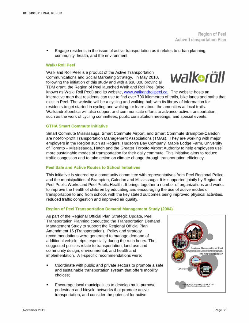
I B I G R O U P F INAL REPORT
Region of Peel Active Transportation Plan
November 2011 Page 56.
� Engage residents in the issue of active transportation as it relates to urban planning, community, health, and the environment.
Walk+Roll Peel
Walk and Roll Peel is a product of the Active Transportation Communications and Social Marketing Strategy. In May 2010, following the initiation of this study and with a $30,000 provincial TDM grant, the Region of Peel launched Walk and Roll Peel (also known as Walk+Roll Peel) and its website, www.walkandrollpeel.ca. The website hosts an interactive map that residents can use to find over 700 kilometres of trails, bike lanes and paths that exist in Peel. The website will be a cycling and walking hub with its library of information for residents to get started in cycling and walking, or learn about the amenities at local trails. Walkandrollpeel.ca will also support and communicate efforts to advance active transportation, such as the work of cycling committees, public consultation meetings, and special events.
GTHA Smart Commute Initiative
Smart Commute Mississauga, Smart Commute Airport, and Smart Commute Brampton-Caledon are not-for-profit Transportation Management Associations (TMAs). They are working with major employers in the Region such as Rogers, Hudson’s Bay Company, Maple Lodge Farm, University of Toronto – Mississauga, Hatch and the Greater Toronto Airport Authority to help employees use more sustainable modes of transportation for their daily commute. This initiative aims to reduce traffic congestion and to take action on climate change through transportation efficiency.
Peel Safe and Active Routes to School Initiatives
This initiative is steered by a community committee with representatives from Peel Regional Police and the municipalities of Brampton, Caledon and Mississauga. It is supported jointly by Region of Peel Public Works and Peel Public Health . It brings together a number of organizations and works to improve the health of children by educating and encouraging the use of active modes of transportation to and from school, with the key stated outcomes being improved physical activities, reduced traffic congestion and improved air quality.
Region of Peel Transportation Demand Management Stu dy (2004)
As part of the Regional Official Plan Strategic Update, Peel Transportation Planning conducted the Transportation Demand Management Study to support the Regional Official Plan Amendment 16 (Transportation). Policy and strategy recommendations were generated to manage demand of additional vehicle trips, especially during the rush hours. The suggested policies relate to transportation, land use and community design, environmental, and health and implementation. AT-specific recommendations were:
� Coordinate with public and private sectors to promote a safe and sustainable transportation system that offers mobility choices;
� Encourage local municipalities to develop multi-purpose pedestrian and bicycle networks that promote active transportation, and consider the potential for active

I B I G R O U P F INAL REPORT
Region of Peel Active Transportation Plan
November 2011 Page 57.
transportation routes on regional roads designed to link with area municipal AT networks; and
� Coordinate with area municipalities to promote land uses and site design which foster alternative and active modes of transportation.
Transportation Demand Management Plan Five-year Pla n for Supplemental Funding
This plan details the TDM priorities and activities for a five-year period (2008-2013), provides information on the recommended phasing for those activities, and estimates program costs. The TDM activities outlined in this five-year plan can be categorized into the following areas: TDM Support Programs; Active Transportation; Regional TDM Programs; and New Programs and Strategies. For Active Transportation, it is recommended that the Region of Peel hire an AT co-ordinator to work with Health Services to encourage the use of active transportation modes by Region of Peel staff and to perform outreach throughout the Region that supports active transportation. All outreach activities will be coordinated with Health Services and any employer outreach activities that occur within the service area of a TMA should be coordinated with the applicable TMA’s staff. It is also recommended that the Region of Peel support a Safe and Active Routes to School program, and develop a grant program that allows schools and local groups to apply for funds for the implementation of educational programs that help create safe and appealing environments for walking and biking to school. Eligible projects would include but not be limited to:
� Creating a bicycle or pedestrian audit
� Implementing a public awareness campaign
� Teaching bicycle skills
� Teaching traffic safety skills
� Developing walking and bicycling school bus programs
� Developing “safe routes to school” maps
Peel Health Communication Programs
Peel Public Health Programs and Resources Peel Public Health, the regional health department, offers a wide range of public health programs and resources to ensure that residents and workers can obtain credible information on preventing illness and can experience supportive environments that promote health. At Peel Public Health, active transportation is a strategic priority for healthy weights and obesity prevention. This priority aligns with Regional Council priorities and priorities of all levels of government. Teams at Peel Public Health offer a variety of programs and resources in chronic disease and injury prevention, and in environment health. Several programs and resources relevant to active transportation are available.
The following highlights some of Peel Public Health’s active transportation supportive programs:

I B I G R O U P F INAL REPORT
Region of Peel Active Transportation Plan
November 2011 Page 58.
20/20 The Way to Clean Air
This is a campaign promoted by public health units across the GTA to help individuals reduce home energy use and vehicle use by 20 per cent each. The campaign promotes walking and cycling as ways to reduce vehicle usage. The Region of Peel is involved in this campaign, but it does not explicitly acknowledge the role of walking and cycling.
Air Quality Health Index (AQHI)
The AQHI is a national health-based index to help individuals protect their health and the health of people in their care. The AQHI uses a simple 10-point scale to indicate the level of health risk associated with local air quality- the higher the reading, the greater the health risk and the greater the need to take precautions. On rare occasions, the Air Quality Health Index may be 10+, which means that there is a very high health risk, and residents (especially children and seniors) should take precautions and reduce strenuous outdoor activity.
Peel Public Health Built Environment Initiatives
Peel Public Health has also been working on a number of initiatives to increase the health-promoting potential of the built environment including the following:
� Creation of the Peel Healthy Development Index (HDI), used to comment on development proposals in Peel Region and provide health-based rationale to inform planning decisions.
� Production of a template for a Health Background Study to be used as part of a complete development application.
� Policy development at each level of the planning policy hierarchy (e.g. By-laws, Regional official plans, provincial plans and provincial policy statements).
More information about public health programs and resources offered to support active transportation can be found on the Peel Health website www.peelregion.ca/health and www.peelregion.ca/health/resources/healthbydesign (September 2011).
6.2.2 Local Municipal Initiatives Mississauga Cycling Advisory Committee Events
Mississauga Cycling Advisory Committee (MCAC) is a committee of Council which was formed in the fall of 1994. It organizes or is involved in various events to promote cycling including:
� Tour de Mississauga—an annual event consisting of 25 to 100 km long bicycle rides through the City showcasing routes, vistas and attractions.
� Bike to Work Day—partnering with Smart Commute Mississauga and the City of Mississauga’s Cycling Office
� Toronto International Bicycle Show—exhibiting information about cycling in Mississauga
� Mississauga Bike Map—promoting and distributing the map of existing bikeways produced by the City

I B I G R O U P F INAL REPORT
Region of Peel Active Transportation Plan
November 2011 Page 59.
Road Watch
The Road Watch promotion campaign was originally developed in Caledon and is now a collaborative initiative between all three Peel municipalities. The program is essentially a service through which residents and visitors can report dangerous and aggressive drivers to the police. Citizens must complete and send in a form to the Peel Regional Police Traffic Services or for provincial highways, the Port Credit Ontario Provincial Police (OPP) detachment.
Mississauga Road Safety Handbook (2011)
This Handbook is a comprehensive guide to driver, pedestrian and cyclist safety in the City. It was produced by the Mississauga Safe Driving Committee in partnership with the Mississauga Traffic Safety Council, Mississauga Cycling Advisory Committee and the Ministry of Transportation Ontario. The Handbook provides safety tips to be taken by drivers, pedestrians, cyclists and police. It also describes the various initiatives run by the City on road safety including for pedestrians and children. These public communication materials are distributed online and at public facilities such as schools, transit, libraries, etc. Two programs are described below.
Road Safety Mississauga
The program covers educational campaigns to promote pedestrian safety in Mississauga (I Am Not a Target). The second phase of the campaign reminds drivers and pedestrians to be aware, especially in low-light conditions (Expect the Unexpected).
Brampton Pedestrian Safety Plan
This document developed by the Works and Transportation Department, serves as the overall planning framework to improve safety conditions for pedestrians. The plan is to be used by staff when considering solutions to pedestrian problems on existing roadways or in new development areas. It also serves to raise public awareness about existing conditions, current practices and new initiatives aimed at improving pedestrian safety. The objectives related to the development of this plan include the following:
� Examine existing pedestrian traffic control devices
� Review pedestrian collision history to identify areas for improvement
� Identify initiatives to improve safety for pedestrians within the existing transportation network
� Identify design alternatives to provide a proactive approach to pedestrian safety in new development areas
I B I G R O U P F INAL REPORT
Region of Peel Active Transportation Plan
November 2011 Page 60.
� Propose an achievable implementation plan
Peel Children's Safety Village
Peel Children's Safety Village is an educational centre specifically designed for students from grades one, three and five. It features a miniature "town" with scaled-down buildings, roadways, traffic lights and signs, an operational railway crossing, and a school bus. It is used to help children demosntate their knowledge of the rules of the road in the "town", using mini electric cars, bicycles and their own two feet.
Bicycle Rodeos / CAN-BIKE Cycling Skills Training
Bicycle rodeos, teaching safe cyclng skills to youth in an off-road environment, have been held in various locations through the Region of Peel hosted by various organizations including Peel Regional Police and Brampton Safe City Association. The Canadian Cycling Association's CAN-BIKE program is a series of courses on all aspects of cycling safely and enjoyably on the road; it is oriented toward recreational and transportation cycling. The CAN-BIKE training program provides a nationally standardized set of courses that can be taught through a variety of organizations who are interested in education, safety, health and life skills. Region of Peel is partnering with area municipalities to offer CAN-BIKE.
6.2.3 Other Agency Initiatives A workshop was held with agency staff to report on active transportation related initiatives (see Section 3.1.1, Agency Workshop No. 1, page 33 for an overview of the workshop). Activities reported by departments and area municipalities were grouped under 30 categories shown in Exhibit 9. A black circle indicates that an activity is being undertaken while a white circle indicates that an activity is under development or in the process of being approved.

I B I G R O U P F INAL REPORT
Region of Peel Active Transportation Plan
November 2011 Page 61.
Exhibit 9: Summary of Departmental and Area Municip alities Activities

I B I G R O U P F INAL REPORT
Region of Peel Active Transportation Plan
November 2011 Page 62.
6.3 Recommended AT Behavioural Shift Programming
A good active transportation plan provides a balance of facilities and programs. Facilities and programs go together—like providing minor sports services. The administration and promotion of teams and leagues is as critical as supplying quality sports facilities. So it is with walking and cycling; one needs attractive places to walk and cycle in order to encourage people to do so, and programming to raise awareness of the viability. Programming efforts must focus on areas in the Region of Peel where active transportation facilities exist, expanding as the network expands.
There are many barriers and challenges in achieving social change, even if the appropriate infrastructure is built to support such a change. Walking already enjoys some popularity in the Region of Peel, and existing, well used, trails provide an environment conducive to recreational and utilitarian active transportation. However, to more fully develop the use of walking and cycling for a wider range of trips, the barriers to active transportation, both within the built environment as well as the more subjective social factors need to be fully understood in order to effectively target behavioural change through various strategies.
Because of the wide range of relevant factors in the decision to engage in active transportation, the strategy to encourage residents and visitors to walk and cycle more will take more effort than the provision of infrastructure. Thus construction of pedestrian and bicycle facilities needs to be complemented by programming strategies to assist people in making the transition to walking and/or bicycling, after having become accustomed to getting around by automobile for many years. By creating a network of support and encouragement programs, it is possible for people to be successful at adopting active transportation behaviours.
6.3.1 Short-Term Strategies (Year 1 and Onward) Recommended short-term strategies to shift behaviou r of residents of Peel to increase use of active transportation are as follows:
Responsibility: Region of Peel’s Walk and Roll Team
� Continue in the design and delivery of Walk and Roll Peel efforts including:
– Strategic special events
– Targeted awareness and behavioural change campaigns
– Promotion of existing trails, paths and destinations in the Region of Peel
– Work with area municipalities to provide cycling and pedestrian safety education
– Partnership building with active transportation supporting programs and stakeholders
� Create and maintain a set of measurements that quantify results of walkandrollpeel.ca.
� Assist in the delivery of the Region of Peel’s Five Year TDM Social Marketing Plan.
� Meet annually with stakeholders to review Walk and Roll Peel marketing efforts, identify opportunities amongst stakeholders’ existing/planned marketing and promotional efforts and plan unique collaborative events.
I B I G R O U P F INAL REPORT
Region of Peel Active Transportation Plan
November 2011 Page 63.
Case Study: Experiential and Guerrilla Marketing— Volkswagen’s Fun Theory Piano Stairs: Experiential marketing connects the target audience with brands in personally relevant and memorable ways–experiencing and participating in a “brand” moment, rather than the usual disruptive, passive advertising messages we are surrounded by today. Guerrilla marketing is a system of promotions that create unexpected and original interactions with the target audience in unexpected places. A recent, popular example that includes both guerrilla and experiential marketing is Volkswagen’s Fun Theory Piano Stairs which turned a typical staircase—located directly next to an escalator—into an interactive piano with each step creating a musical note. This simple and unusual promotion increased the number of pedestrians taking the stairs rather than the escalator.
http://www.thefuntheory.com/piano-staircase, February 2010
� Develop an annual business plan based on results of the aforementioned strategies and which identifies major tasks to accomplish, timelines and metrics.
� Work with the area municipalities to review the options and feasibility of experiential marketing and guerrilla efforts near and on active transportation infrastructure. These efforts will generate opportunities to create awareness and reposition active transportation.
� Encourage area municipalities to provide marketing and communications support for Walk and Roll Peel campaign efforts. Examples include provision of existing communications modes, campaign participation by municipal staff, and/or other appropriate campaign support.
6.3.2 Medium and Longer-Term Strategy (Year 2 and Onward)
Walk and Roll Community-based Social Marketing
To provide a measurable return on investment of active transportation marketing efforts, it is recommended that the Region conduct community-based social marketing (CBSM) efforts amongst neighbourhoods and/or activity centres with access to existing active transportation infrastructure. This should be done in collaboration and partnership with the area municipalities, including program development, implementation and evaluation. CBSM programs use a unique outreach technique to segment targeted populations based on their willingness to use active modes of transportation. Outreach efforts are then targeted toward members of the population who are considered most likely to increase their use of active modes of
AT Plan Recommendation: Recommended short-term strategies for the Region of Peel’s Walk and Roll Team include: � Deliver and monitor the Walk +
Roll Peel campaign � Meet annually with stakeholders
regarding Walk + Roll Peel � Assist in the delivery of the Region
of Peel’s Five Year TDM Social Marketing Plan
� Develop an annual business plan for the above
� Work with the area municipalities to review the options and feasibility of experiential marketing and guerrilla efforts near and on active transportation infrastructure
� Encourage area municipalities to provide marketing and communications support for the Walk + Roll Peel campaign

I B I G R O U P F INAL REPORT
Region of Peel Active Transportation Plan
November 2011 Page 64.
transportation. CBSM programs have proven highly successful at moving people into active modes of transportation while creating larger-scale program and behaviour awareness.
The Region should implement a residential based CBSM program in years two and three based on activity centres to be determined by further analysis in this plan. Lessons learned will be applied to implement in both years four and five. Each campaign will span an entire calendar year to design, prepare, implement, and evaluate.
Designing a CBSM program requires the identification of target areas based on proximity to existing, newly constructed, or shortly upcoming active transportation infrastructure. Subsequently, intercept surveys should be utilized to assess barriers and benefits to active transportation for residents of the local communities surrounding the identified infrastructure.
The identification and implementation at local target areas will require close coordination with area municipalities. CBSM programs will be led and implemented by the Region of Peel, but each area municipality can support the delivery through the provision of existing communications modes, unique insight of target area, and/or other appropriate program support. Staff from Peel Transportation can partner with staff from Peel Public Health who are specialized in the trans-theoretical model of behaviour change, as illustrated in Exhibit 10, and aware of Smart Commute work.
Implementing and evaluating a residential CBSM program is often a five-step process that involves a before survey, segmentation, information distribution, motivation and barrier removal, and evaluation. For consideration in the design of future CBSM projects, each step of the process is described below.
6.3.2.1.1 BEFORE SURVEY
A paper-based and/or web survey is distributed to residents for the purpose of creating a baseline of current behaviour and segmenting the resident population into four groups. These groups are: (1) interested in using active transportation modes; (2) regular users of active transportation; (3) regular users interested in using more active transportation modes; and (4) not interested or not feasible in using active transportation. Specific questioning should be included that identifies barriers and benefits to behaviour participation. Residents are offered incentives to participate in the survey and reminder prompts are used to further encourage survey participation. Due to the diversity of the Peel population, translation of survey efforts should be considered after identifying project area.
Segmentation
Survey respondents are segmented into the four groups listed above based on their responses to specific questions within the survey instrument. Individuals who are classified as not interested in using active transportation are excluded from further marketing efforts.
Information Distribution
Order forms for transportation related marketing materials are sent out to individuals who are defined as interested and regular users of active transportation modes. The order forms are returned to the Region of Peel project manager and customized marketing materials are returned to
AT Plan Recommendation: The recommended longer-term strategy for AT Behavioural Shift Programming is for the Region of Peel to conduct community-based social marketing (CBSM) efforts amongst neighbourhoods and/or activity centres with access to existing active transportation infrastructure. This should be done in collaboration and partnership with the area municipalities, including program development, implementation and evaluation

I B I G R O U P F INAL REPORT
Region of Peel Active Transportation Plan
November 2011 Page 65.
residents based on their unique interests. An incentive is offered in order to achieve a high response rate.
Motivation & Barrier Removal
In addition to information, the entire community is offered incentives to use active transportation modes and ways to increase motivation and overcome identified barriers. Incentives can include free and reduced cost transit passes, new infrastructure (bike racks, signage, etc), bike locks, bike helmets, and commuter bags. Promotional events such as transportation fairs are also held to further push the message of active transportation use and to offer an additional medium for the distribution of transportation-related information. Experiential marketing efforts will also be utilized to reinforce messaging of the preferred behaviour. This stage of the program ensures the entire community at-large benefits from the CBSM project.
Evaluation
A post-program survey is distributed to residents. All residents are asked to participate in the survey and the collected information is used to determine the mode split change, number of trips reduced, and number of vehicle kilometres of travel reduced as a result of the program.
Exhibit 10: Trans-theoretical Model of Behaviour Ch ange and Recommended AT Programming
LEGEND: � Development or adoption of recommendation � Implementation or continued execution
Timeframe
Stages of Change Recommended Programming
Sh
ort
Med
ium
Lo
ng
Pre-contemplation Contemplation
Promote and Expand Overall Active Transportation Communications � Promote and expand active transportation social media communications, such as
WalkandRollPeel.ca � Promote and expand maps for trails/paths and destinations
� � ����
Preparation Supportive Network Policies and Infrastructure � Development of accessible, safe and integrated active transportation policies and
networks in Peel Community Engagement and Mobilization � Conduct stakeholder engagement (e.g. workshops, champion support) at
regional/municipal, community/neighbourhood, workplace and school-levels to support capacity building and continued development of active transportation supportive policies and programming in Peel
� �
� ����
����
Action Maintenance
Develop, Implement and Evaluate Behaviour Change Programming to encourage use of the Active Transportation Network, including: � Tailored community-based social marketing /neighbourhood-level
encouragement programming, building on existing Walk and Roll strategies � Tailored school-level encouragement programming, building on existing Peel
Safe and Active Routes to School strategies
���� ����
���� ����
����
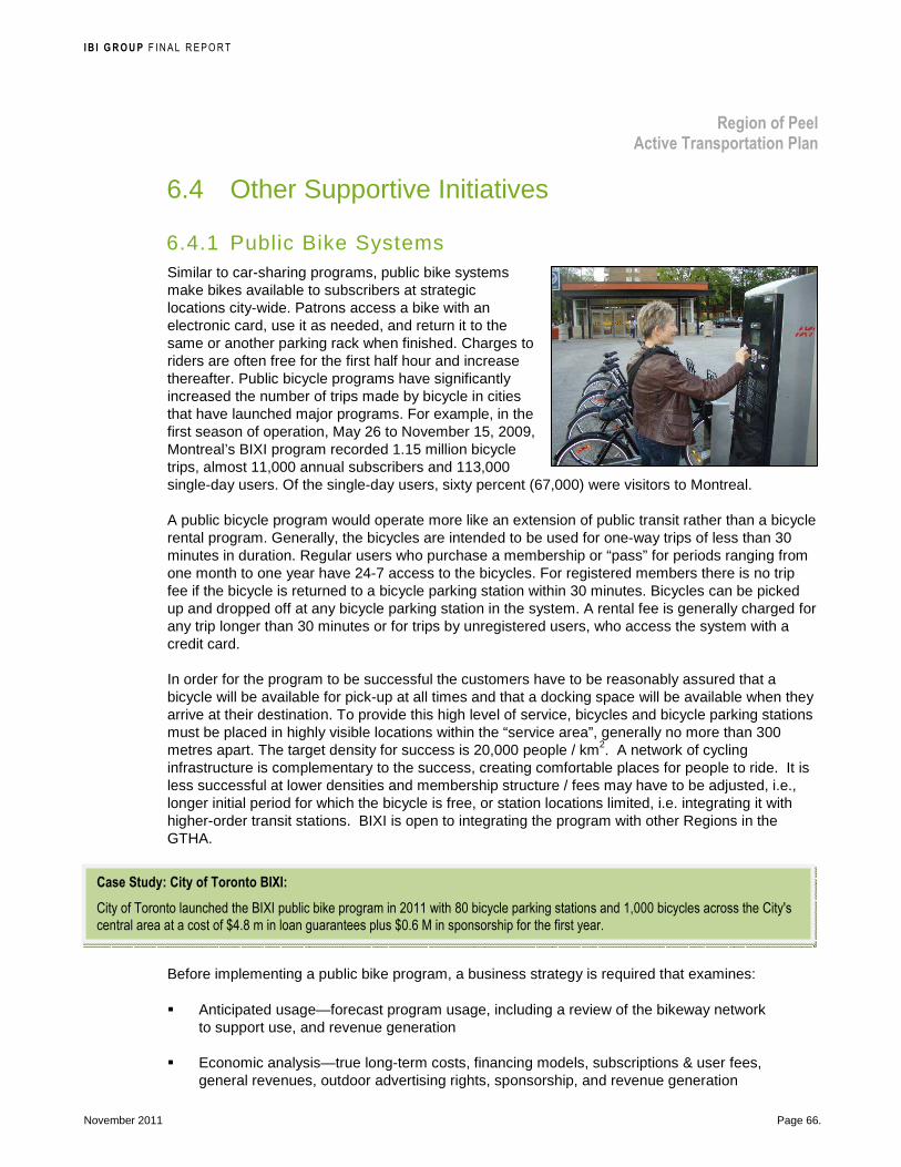
I B I G R O U P F INAL REPORT
Region of Peel Active Transportation Plan
November 2011 Page 66.
Case Study: City of Toronto BIXI:
City of Toronto launched the BIXI public bike program in 2011 with 80 bicycle parking stations and 1,000 bicycles across the City's central area at a cost of $4.8 m in loan guarantees plus $0.6 M in sponsorship for the first year.
6.4 Other Supportive Initiatives
6.4.1 Public Bike Systems Similar to car-sharing programs, public bike systems make bikes available to subscribers at strategic locations city-wide. Patrons access a bike with an electronic card, use it as needed, and return it to the same or another parking rack when finished. Charges to riders are often free for the first half hour and increase thereafter. Public bicycle programs have significantly increased the number of trips made by bicycle in cities that have launched major programs. For example, in the first season of operation, May 26 to November 15, 2009, Montreal’s BIXI program recorded 1.15 million bicycle trips, almost 11,000 annual subscribers and 113,000 single-day users. Of the single-day users, sixty percent (67,000) were visitors to Montreal.
A public bicycle program would operate more like an extension of public transit rather than a bicycle rental program. Generally, the bicycles are intended to be used for one-way trips of less than 30 minutes in duration. Regular users who purchase a membership or “pass” for periods ranging from one month to one year have 24-7 access to the bicycles. For registered members there is no trip fee if the bicycle is returned to a bicycle parking station within 30 minutes. Bicycles can be picked up and dropped off at any bicycle parking station in the system. A rental fee is generally charged for any trip longer than 30 minutes or for trips by unregistered users, who access the system with a credit card.
In order for the program to be successful the customers have to be reasonably assured that a bicycle will be available for pick-up at all times and that a docking space will be available when they arrive at their destination. To provide this high level of service, bicycles and bicycle parking stations must be placed in highly visible locations within the “service area”, generally no more than 300 metres apart. The target density for success is 20,000 people / km2. A network of cycling infrastructure is complementary to the success, creating comfortable places for people to ride. It is less successful at lower densities and membership structure / fees may have to be adjusted, i.e., longer initial period for which the bicycle is free, or station locations limited, i.e. integrating it with higher-order transit stations. BIXI is open to integrating the program with other Regions in the GTHA.
Before implementing a public bike program, a business strategy is required that examines:
� Anticipated usage—forecast program usage, including a review of the bikeway network to support use, and revenue generation
� Economic analysis—true long-term costs, financing models, subscriptions & user fees, general revenues, outdoor advertising rights, sponsorship, and revenue generation

I B I G R O U P F INAL REPORT
Region of Peel Active Transportation Plan
November 2011 Page 67.
Case Study: La Route Verte
Regional and even national cycle tourism networks elsewhere in Canada and the world have succeeded in attracting local and international tourists. Inspiring is La Route verte in the Province of Québec. It is a 4,000 km long network of bicycle routes that link 16 regions and more than 320 municipalities. It was officially inaugurated on August 10, 2007 with 86% of the network complete. Based on a concept developed by Vélo Québec, La Route verte has been under development since 1995, with the collaboration of Transport Québec as well as numerous regional partners. The network was expanded by:
� Using pubic rights-of-way such as abandoned rail corridors, tow paths and hydroelectric rights-of-way.
� Paving shoulders to make roads safer for cyclists.
� Identifying certain rural roads with little traffic as “designated cycling routes”.
Vélo Québec reported that between 1978 and 2005, the government of Québec invested over $104 million in the development if bikeways, including $60 million on La Route verte. Paved shoulders, non-existent in 1995, are now more than 1,400 km in length.
In 2000, La Route verte cyclists spent a total of $95.4 million. This corresponds to approximately 2,000 jobs (person years) and revenues of $15.1 million for the Government of Québec and $11.9 million for the Government of Canada. Québec cycling tourists spent a total of $54.6 million and people who live near La Route verte spent over $24.5 million.
Vélo Québec’s travel agency serves 6,000 cyclists a year with 2,000 of them enjoying Le Grand tour over seven days in Québec.
� Fare structure and pricing—payment methods, cash, credit card, smart cards, and user accountability
� Operating model and impacts for each model—agency to own and operate, agency to own but private company operate, private company owns and operates, etc.
It is recommended that the Region of Peel support a rea municipalities in the monitoring the implementation of public bike systems in North America and provide support for a high-level feasibility review over the next five years.
6.4.2 Active Transportation Tourism Supporting walking and cycling can enhance several sectors of the economy:
� Create a healthier work force.
� Improve the quality of life leading to a vibrant community that attracts business.
� Support recreational activities of residents with the investment remaining local.
� Attract tourists to explore and enjoy a more vibrant community.
� Create an activity-based tourism sector.
AT Plan Recommendation: The Region of Peel support area municipalities in the monitoring the implementation of public bike systems in North America and provide support for a high-level feasibility review over the next five years.
Photo credit: John J. Barnhardt
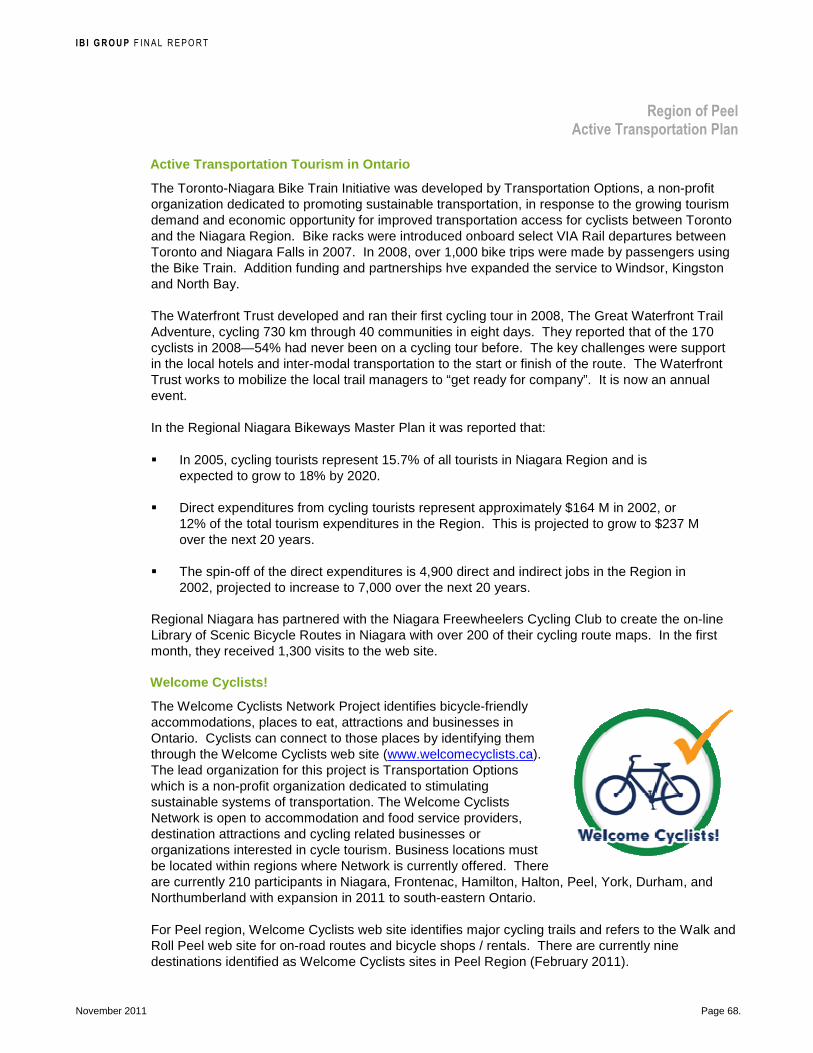
I B I G R O U P F INAL REPORT
Region of Peel Active Transportation Plan
November 2011 Page 68.
Active Transportation Tourism in Ontario
The Toronto-Niagara Bike Train Initiative was developed by Transportation Options, a non-profit organization dedicated to promoting sustainable transportation, in response to the growing tourism demand and economic opportunity for improved transportation access for cyclists between Toronto and the Niagara Region. Bike racks were introduced onboard select VIA Rail departures between Toronto and Niagara Falls in 2007. In 2008, over 1,000 bike trips were made by passengers using the Bike Train. Addition funding and partnerships hve expanded the service to Windsor, Kingston and North Bay.
The Waterfront Trust developed and ran their first cycling tour in 2008, The Great Waterfront Trail Adventure, cycling 730 km through 40 communities in eight days. They reported that of the 170 cyclists in 2008—54% had never been on a cycling tour before. The key challenges were support in the local hotels and inter-modal transportation to the start or finish of the route. The Waterfront Trust works to mobilize the local trail managers to “get ready for company”. It is now an annual event.
In the Regional Niagara Bikeways Master Plan it was reported that:
� In 2005, cycling tourists represent 15.7% of all tourists in Niagara Region and is expected to grow to 18% by 2020.
� Direct expenditures from cycling tourists represent approximately $164 M in 2002, or 12% of the total tourism expenditures in the Region. This is projected to grow to $237 M over the next 20 years.
� The spin-off of the direct expenditures is 4,900 direct and indirect jobs in the Region in 2002, projected to increase to 7,000 over the next 20 years.
Regional Niagara has partnered with the Niagara Freewheelers Cycling Club to create the on-line Library of Scenic Bicycle Routes in Niagara with over 200 of their cycling route maps. In the first month, they received 1,300 visits to the web site.
Welcome Cyclists!
The Welcome Cyclists Network Project identifies bicycle-friendly accommodations, places to eat, attractions and businesses in Ontario. Cyclists can connect to those places by identifying them through the Welcome Cyclists web site (www.welcomecyclists.ca). The lead organization for this project is Transportation Options which is a non-profit organization dedicated to stimulating sustainable systems of transportation. The Welcome Cyclists Network is open to accommodation and food service providers, destination attractions and cycling related businesses or organizations interested in cycle tourism. Business locations must be located within regions where Network is currently offered. There are currently 210 participants in Niagara, Frontenac, Hamilton, Halton, Peel, York, Durham, and Northumberland with expansion in 2011 to south-eastern Ontario.
For Peel region, Welcome Cyclists web site identifies major cycling trails and refers to the Walk and Roll Peel web site for on-road routes and bicycle shops / rentals. There are currently nine destinations identified as Welcome Cyclists sites in Peel Region (February 2011).

I B I G R O U P F INAL REPORT
Region of Peel Active Transportation Plan
November 2011 Page 69.
Travel Activities and Motivation Survey—Cycling Tri ps
The Travel Activates and Motivation Survey (TAMS) examines the recreational activities and travel habits of Canadians and Americans for out-of-town, overnight travel for one or more nights over the two year period of 2004 and 2005. For cycling, the survey examines recreational same-day excursions, mountain biking, and overnight cycle touring. Some of the results of the survey are summarized in Exhibit 11.
Exhibit 11: Characteristics of Canadian and America n Pleasure Travels to Canada who Participated in Cycling While on an Out-of-town, Ov ernight Stay of One or More Nights
(2004 and 2005)
Characteristics Canadian Pleasure Travellers American Pleasure Travellers
No. of adults who went cycling 10.1% (2.94 M) 4.9% (10.9 M)
Participated in— Recreational same-day cycling excursion: Mountain biking: Overnight cycle touring: All three cycling activities
8.3% 3.0% 1.0% 0.3%
3.8% 1.5% 0.4% 0.1%
Gender and Age � More likely male � 25 to 54 years of age
More likely to have children under 18 than non-cyclist pleasure travellers
Average Age 40.6 41.8
Level of Education Above average—38.9% with university degree
Above average—72.2% with university degree
Average Household Income Above average—$78,800 Above average—$91,200
Travelling to Ontario 58.2% (1.71 M) 14.3% (1.56 M)
Culture and entertainment pursued while on trips
� More than half pursue: � Shopping and dining � Historical sites, museums
and art galleries � Theme parks and exhibits � Fairs and festivals � Musical concerts, festivals
and attractions
� More than half pursue: � Shopping and dining � Historical sites, museums and
art galleries � Theme parks and exhibits � Casino, theatre and comedy
clubs � Fine dining and spas
Use of internet to plan and book travel
Plan—75.3% Book travel—48.7%
Plan—84.9% Book travel—64.6%
Preferred accommodations Public campgrounds, wilderness campsites and resorts
Public campgrounds and various types of resorts

I B I G R O U P F INAL REPORT
Region of Peel Active Transportation Plan
November 2011 Page 70.
Region of Peel Context and Recommendations
The Ministry of Tourism and Culture, Ontario has recently developed Regional Tourism Organizations in the province's 13 new tourism regions. Each Regional Tourism Organization is independent, industry-led and not-for-profit and responsible for building and supporting competitive and sustainable tourism. This strategy is intended to help attract more visitors, generate more economic activity, and create more jobs across the province.
The Town of Caledon, as part of the Hills of the Headwaters Tourism Association, is in the York, Durham and Hills of Headwaters Tourism Region (Zone 6), while the Cities of Brampton and Mississauga are in the Greater Toronto Area Tourism Region (Zone 5). Hiking and cycling are both profiled for the Town of Caledon in the Hills of the Headwaters Tourism Association web site (www.thehillsofheadwaters.com). Heritage walking tours in Mississauga are profiled on the Greater Toronto Area Tourism Region web site (www.seetorontonow.com).
As identified in the Tourism Brampton’s Premier-ranked Tourist Destination Framework (2009), visiting friends and relatives is a large part of the tourism sector in Brampton. The framework recommends that more focus on local residents is required to ensure that they are aware of what is available in the community and that they are encouraging their guests to enjoy the community assets. The City of Mississauga’s Premier-ranked Tourist Destination Evaluation (2004) indicates that the scenic and accessible waterfront is an asset.
The Region of Peel and area municipalities should w ork within the Regional Tourism Organizations to promote active tr ansportation tourism in the region. The Region of Peel’s Active Transportation Program Co-ordinator would take a liaison role between the RTOs and the area municipalities. It is an opportune time to become involved as the new RTOs define their strategies and products.
An active transportation tourism marketing strategy in the Region of Peel should generate interest in the varied active transportation opportunities in the region, provide information about active
transportation resources to assist travelers in planning vacations, direct users to areas where road and traffic conditions, landscape and services create a positive experience, and stimulate private-sector investment in making the region an active transportation tourism destination. Approaches could include:
� Support municipalities in leveraging promotional activities for major events such as festivals and sporting events, encouraging visitors to access events on foot or by bicycle, and developing a strategy of bicycle valet parking. This includes the 2015 Pan Am games.
� Continue to support promotion of the Lake Ontario Waterfront Trail, the Tour de Greenbelt, the Tour de Mississauga, and the Tour de Terra Cotta.
� Support municipalities in extending programs such as Go by Bike (www.BikesandTransit.com ) that markets GTA visitors to take their bicycle on the GO train on weekends and travel to a municipality to explore their bike routes and trails.
� Continue to promote walking, hiking and cycling trails and routes through the Walk and Roll Peel campaign and provide support by linking to other tourism strategies.
AT Plan Recommendation: The Region of Peel and area municipalities should work within the Regional Tourism Organizations to promote active transportation tourism in the region, with the Region’s AT Co-ordinator as liaison between the RTOs and the area municipalities.
I B I G R O U P F INAL REPORT
Region of Peel Active Transportation Plan
November 2011 Page 71.
Based on the successful structure of SwitzerlandMobility, tapping into the active transportation tourism market requires investment in:
� The development and maintenance of routes in the urban and rural areas of the region.
� Way-finding and destination signage and information along the route.
� Information such as guidebooks and maps (hard copy and/or electronic) about the routes, accommodation, services, events and public transportation transfer or access points.
� Publicity or marketing via various media and partners to guests.
� Finally, the guests returning investment to the region.
Funding for the creation of tourism experiences and innovative product development for emerging markets is available through the Ontario Ministry of Tourism’s Tourism Development Fund (http://www.mtc.gov.on.ca/en/awards_funding/tourism_dev_fund.shtml, February 2011).
6.4.3 Bicycle Parking Several studies suggest that fear of bicycle theft may discourage bicycle use and that many bicycle theft victims do not buy a replacement.10 Combating bicycle theft is therefore a necessary step toward increasing the use of this form of active transportation. Bicycle parking can encourage people to bike because they have a place to lock their bicycle at their destination. Designated bicycle parking installed properly in a good location is more orderly, prevents damage to trees, street furniture and prevents bikes from blocking the sidewalk or other pedestrian or vehicular paths. It also helps legitimize cycling as transportation and supports economic development.
Short-term bicycle parking for less than a few hours can consist of a simple rack designed to support the frame of the bicycle and allow locking of both the frame and the two wheels. They are usually provided for visitors and shoppers. Long-term bicycle parking for more than a few hours consists of racks or lockers, secured or enclosed, and sheltered or indoors. It is typically provided at multi-family residential development, workplaces and transit stations.
Bicycle Parking Guidelines
Good bicycle parking is an easy concept but often executed poorly with racks unusable, empty or damaged. Bicycle parking guidelines address:
� Good parking racks versus poor racks for supporting and locking bicycles.
� The location of racks generally on a site or along a public road.
10 Johnson, Shane D, Aiden Sidebottom, and Adam Thorpe, Bicycle Theft, Guide No. 52 Centre for Problem- Oriented Policing (2008)

I B I G R O U P F INAL REPORT
Region of Peel Active Transportation Plan
November 2011 Page 72.
� The spacing of racks in relationship to each other and other obstacles or building walls to allow easy access by cyclists and room for multiple bicycles.
Expanded guidelines can include information on bicycle shelters, enclosures, lockers, and related amenities such as clothing lockers or racks, wash basins, change rooms, showers, etc. The Association of Pedestrian and Bicycle Professionals (APBP) has published Bicycle Parking Guidelines that include a discussion of the rack element, combining multiple racks into a parking area, and the location of bicycle parking in relation to building entrances (http://www.apbp.org/resource/resmgr/publications/bicycle_parking_guidelines.pdf, March 2010 )
The City of Toronto has developed draft Guidelines for the Design and Management of Bicycle Parking Facilities (http://www.toronto.ca/planning/bicycle_parking_guide.htm, March 2010) intended to improve the quality of bicycle parking that is secured through the development approval process. The Guidelines provide planners, developers and property managers with information to support the design, construction and management of high quality bicycle parking facilities. Although aimed at new developments, the Bicycle Parking Guidelines can also be applied to existing developments looking to improve bicycle parking facilities.
The City of Portland, OR, provides a Bicycle Parking Facilities Guidelines on their web site (http://www.portlandonline.com/transportation/index.cfm?c=34813&a=58409, March 2010) that covers the basics of what is a good rack and a good location. The guide is intended to help property owners save money by installing bicycle parking facilities that work, whether they are required or volunteering to install bicycle parking. The guide suggests that "if you see bicycles locked to trees, posts or other stationary objects nearby, you probably need bicycle parking. If you have bicycle parking that is rarely used it may be poorly located or of a type that offers little security." Links on the same web page are provided for the City's bicycle parking maps, bike locker rental program, and Bike Central program providing access for a monthly fee to showers and change rooms.
Bicycle Rack Supply Programs
Sample programs that address the supply of bicycle parking within public rights-of-way are as follows:
� The City of Toronto installs hundreds of post and ring bicycle parking racks on City sidewalks and boulevards every year (http://www.toronto.ca/cycling/postandring.htm, March 2010). The stands are provided free of charge in response to requests received from businesses, residents and cyclists. The program is intended to provide public bicycle parking facilities at destinations that are regularly frequented by cyclists. Priority is given to locations where there are few suitable alternatives (parking meters, sign posts, etc.). Transportation Services staff perform site inspections at all requested locations. The City of Portland, OR, also installs free bicycle racks on the sidewalk in front of businesses as long as the location meets minimum requirements (http://www.portlandonline.com/transport?c=34813&a=58384, March 2010). Over 2000 have been installed to date.
� The Boston Metropolitan Area Planning Council ME (MPAC) had a Regional Bike Parking Program that provides communities in MAPC's region with the opportunity to purchase bike racks through a discount purchase contract with three suppliers.
� The Cities of Burlington and Whitehorse have programs that install bicycle racks as part of public art programs. The bicycle racks outside the Royal Ontario Museum reflect the museums themes.

I B I G R O U P F INAL REPORT
Region of Peel Active Transportation Plan
November 2011 Page 73.
It is recommended that the Region of Peel assist in providing bicycle parking and other end-of-trip facilities th rough the following initiatives:
� Encourage the area municipalities who have not done so to adopt design guidelines for new and retrofit shorter-term bicycle parking (bicycle racks), long-term, more secure bicycle parking (enclosures, lockers, bicycle rooms, etc.) and shower / change rooms and amenities.
� Encourage the area municipalities who have not done so to revise zoning by-laws and development policie s, as required, for all land uses other than single fa mily to address the need for shorter-term bicycle parking f or visitors and longer-term, more secure bicycle parki ng for residents or employees. If longer-term bicycle parking is required, encourage the expansion of the by-laws to include complimentary change rooms / shower s and related amenities.
� Provide end-of-trip facilities at all Regional-owne d properties as appropriate based on visitor and employee latent demand and best practices.
� Work with the area municipalities to develop a bicy cle parking program to encourage the retrofit of bicycle racks at existing developments including schools , considering bulk-purchase, subsidy, advisory services on locating the racks, or other mechanisms.
AT Plan Recommendation: The Region of Peel will assist in providing bicycle parking and other end-of-trip facilities by: � Encouraging the area
municipalities to adopt design guidelines
� Encouraging the area municipalities to revise zoning by-laws and development policies, as required, for all land uses other than single family
� Providing end-of-trip facilities at all Regional-owned properties as appropriate
� Work with the area municipalities to develop a bicycle parking program to encourage the retrofit of bicycle racks at existing developments including schools

I B I G R O U P F INAL REPORT
Region of Peel Active Transportation Plan
November 2011 Page 74
Lesson Learned: What are the indicators of a more walkable, bike-friendly community?— In an attempt to answer “what are the conditions that would encourage more people to walk or cycle to work?”, over 50 academic and government papers were reviewed resulting in a list of 78 unique active transportation indicators grouped into five categories: Infrastructure, Safety, Travel Behaviour, Demography, Geography. Key messages from this review include:
Infrastructure:
� Bike lanes and paths have been consistently correlated by multiple researches with higher rates of bicycle use. Cities with more kilometres of cycling facilities per square kilometre generally have higher levels of cycling
� Low speed limits were observed in cities with high levels of active transportation � High-speed traffic greatly decreases the comfort of pedestrians and can be a major deterrent to pedestrian trips � The safe integration of bicycle traffic with motor traffic (shared space) requires a low speed of traffic flow, which is beneficial to
both actual and perceived safety of cyclists � Local government has a profound effect on walkability because of the planning decisions they make that affect urban design
and also through their role in community leadership
Safety:
� The rate of injury between cyclists, pedestrians and the occupants of motor vehicles is greatly misaligned, i.e., a greater number of pedestrians and cyclists are seriously injured or killed by cars than car occupants
� Consistently, researchers have found that traffic regulations and enforcement policies that favour pedestrians and cyclists over motorists are positively correlated with active transportation rates
� In bicycle-friendly countries, motorists are expected to “anticipate unsafe walking and cycling”
Travel Behaviour:
� Reducing trip distance is an absolute requirement to facilitate increased active transportation levels � Europeans pay dramatically higher taxes on gasoline and new cars than North Americans
Demography:
� Built environments were shown to have a stronger impact on walking and cycling at the point of origin / residence as opposed to the point of destination
Geography:
� Rainfall is not a significant deterrent to bicycle commuting � Deficiencies in access have been consistently cited as the number one barrier to active transportation
Beham, Kevin and Nancy Smith Lea, Benchmarking Active Transportation in Canadian Cities, Clean Air Partnership, Toronto, 2010, http://www.cleanairpartnership.org/files/TCAT_AT%20Benchmarking%20Report.pdf, December 2010.
7 ACTIVE TRANSPORTATION NETWORK
The Region of Peel is comprised of three area municipalities: Caledon, Brampton and Mississauga in geographic order from north to south. Caledon has the largest land area and the smallest population; the area is rural in nature consisting mostly of farmlands, natural areas, and smaller communities. Some of these smaller, rural communities often have short distances to places such as the public school, retail services, and other institutions. Mississauga has the largest population, however more undeveloped land remains in Brampton. Both are roughly the same land size and show suburban characteristics with predominantly low density residential areas separated from employment lands, which are concentrated, for example, around the Toronto Pearson International airport located in the northeast corner of Mississauga and in other locations. Mixed land-uses and higher population densities exist in the downtown cores in Brampton and Mississauga.

I B I G R O U P F INAL REPORT
Region of Peel Active Transportation Plan
November 2011 Page 75.
It will be important to not only recommend an active transportation network that responds to current needs and opportunities, but also anticipates the population and employment growth in the Region. Close to 1.4 million people, 521,000 households and 875,000 jobs have been forecasted for 2031 within the Region of Peel according to the Growth Plan / ROPA 24, which represents a 40% increase in population from 2006. In addition, Peel is projected to have proportionally fewer young adults and more seniors compared to today. Downtown Brampton and Mississauga City Centre are identified as Greater Toronto Area (GTA) Urban Growth Centres, each with minimum density targets of 200 people and jobs per hectare to be achieved by 2031. The Town of Caledon is expected to double to 111,000 people by 2031 with 48,000 jobs.11
7.1 Approach Regional roads in rural communities, suburban and urban areas provide for regional trip-making and mobility, but also provide access to the wide variety of land uses adjacent to these roads and transit services along these roads. Access may be direct, or indirect through interconnecting local and collector roads. Thus, an active transportation network for the Region of Peel must address the ability of pedestrians and cyclists to move along and across all Regional roads in developed areas provide for longer cycling trips in rural areas to move between rural communities, and provide access to transit stations.
The predominant operational characteristics of Regional roads are the higher speed and volume of mixed traffic (i.e., passenger cars, transit vehicles, and trucks) served by these roads. These characteristics may in some cases negatively affect the comfort and safety of pedestrians and cyclists. However, given the importance of these roads in providing access to and from major activities and transit hubs, it is recommended that active transportation facili ties be provided within all Regional road corridors, where feasible and possible .
It is also important that those active transportation facilities provide “separate space” for pedestrians and cyclists since it would be unreasonable and potentially unsafe for many active transportation users to share space with motor vehicle traffic under the high speed, volume and mix of traffic conditions. It is recommended that active transportation facili ties along Regional roads consist of sidewalks and boulevard trails for pedes trians; and boulevard trails, bike lanes, segregated bike lanes and paved shoulders (on rural roads) for cyclists, where feasible and possible. Shared facilities, such as signed-only routes, wide shared lanes, marked shared-use lanes and bicycle boulevards are not appropriate for Regional roads with few exceptions. See Section 8, Active Transportation Facilities Reference Guide, page 98, for additional information on these active transportation facilities.
There is clear recognition that the built environment has a significant influence on whether people use active transportation or not. It is not only the presence of active transportation facilities, but the environment in which they are provided that has an effect. In general, roads under the jurisdiction of the Region of Peel are multi-lane, higher speed, widely spaced arterial roadways and have been built or are planned to accommodate the mobility of motorists and commercial vehicles. This presents a challenge in that the space required to accommodate these regional transportation needs necessitates a wider Right-of-Way (ROW). While there is a temptation to simply increase the width of the ROW to accommodate active transportation needs, this approach should be avoided. Increasing Regional road rights-of-way beyond 45 m (typical Regional road ROW width) will only serve to increase the separation of activities within a corridor and reduce the percentage of
11 Figures updated from those in Places to Grow, based on ROPA 24, June 23, 2009, http://www.peelregion.ca/planning/officialplan/pdfs/Ropa24-places-prosper.pdf, August 8, 2010.

I B I G R O U P F INAL REPORT
Region of Peel Active Transportation Plan
November 2011 Page 76.
the ROW that is dedicated to non-motorized transportation. It is recommended that the proposed active transportation facilities be provided within the existing / planned Regional road rights-of-way, where feasible and possible . Future policy discussions on design strategies will need to consider the active transportation requirements within the context of other evolving roadway strategies such as lane widths, higher-order transit strategies, intersection innovations, transportation demand strategies, etc.
In summary, the approach to developing an active transportation network for the Region of Peel is based on:
� Active transportation should be accommodated within all Regional road corridors to provide access to adjacent land uses and destinations, such as housin g, employment, retail services, community services and institutions;
� Active transportation facilities along Regional roa ds generally need to provide separate space for users to address safety and comfort, such as sidewalks and boulevard trails for pedestrians; and boulevard tra ils, bike lanes, segregated bike lanes and paved shoulde rs (on rural roads) for cyclists, where possible and feasible; and
� Proposed active transportation facilities should generally be provided within the existing / planned Regional road rights-of-way width in order to contr ibute to creating more compact, multi-modal corridors.
The active transportation network was developed by mapping opportunities and constraints, reviewing aerial photography and field visits, considering Regional and local municipal plans, and incorporating agency, stakeholder and public input. The following contextual information was considered in the development of both the pedestrian network and the cycling network and are described in detail in the subsequent sections of this report:
� Regional road network (Map 1): existing municipal, Regional and Provincial roads; and future Regional roads
� Existing and planned pedestrian network (Map series 2): existing sidewalks along Regional roads; planned sidewalks and multi-use trails along Regional roads from the Region of Peel’s Capital Road Improvement Program; existing and planned municipal paths; hiking trails from the Toronto Region Conservation Authority (TRCA), Credit Valley Conservation (CVC), Bruce Trail Association and Oak Ridges Trail Association;
� Existing and planned cycling networks (Map series 3 ): existing paved shoulders along Regional roads; planned multi-use trails and paved shoulders along Regional roads from the Region of Peel’s Capital Road Improvement Program; existing and planned municipal bikeways and paths; location of existing / planned bikeway and path connections to adjacent municipalities; valleylands and parks.
� Land use (Map 4): land use excerpted from the area municipal and Regional Official Plans—The Region of Peel Regional Structure (ROP Schedule D, April 2010) illustrates
AT Plan Recommendation: Active transportation should be: � Accommodated within all Regional
road corridors to provide access to adjacent land uses and destinations
� Provided generally in separate space along Regional roads, such as sidewalks and boulevard trails for pedestrians; and boulevard trails, bike lanes, segregated bike lanes and paved shoulders (on rural roads) for cyclists, where possible and feasible
� Provided generally within the existing / planned Regional road rights-of-way width in order to contribute to creating more compact, multi-modal corridors

I B I G R O U P F INAL REPORT
Region of Peel Active Transportation Plan
November 2011 Page 77.
urban and rural systems, conceptual urban growth centres, rural service centres, estate residential communities, airport, settlement study areas, conceptual strategic infrastructure study area (future corridor), and conceptual regional intensification corridor. The Town of Caledon Town Structure (OP Schedule A1, December 2008) illustrates the Greenbelt, Niagara Escarpment and Oak Ridges Moraine Conservation Plan areas, protected countryside designations, growth plan areas, conceptual strategic infrastructure study area (future corridor), major transit station study areas, villages, hamlets, industrial / commercial centres, Palgrave estate residential community, Coulterville special study area, rural service centres, and settlement study areas. The City of Brampton City Concept (OP Schedule 1, August 2009) illustrates the central area, communities, unique communities, employment areas, northwest Brampton urban development area, intensification corridors, Provincial Greenbelt / protected countryside, and open space system. The City of Mississauga Urban System (OP Schedule 1, September 2010) illustrates the downtown, major nodes, community nodes, neighbourhoods, corporate centres, employment areas, special purpose area (airport), corridors and intensification corridors, and the green system.
� Existing and Proposed Transit (Map 5): major transit stops including GO transit stations / stops, GO Transit and local bus terminals, existing and planned Brampton Bus Rapid Transit (BRT) Züm stops, and planned Mississauga BRT MiWay stops; transit routes including local routes on Regional and local roads, GO Transit BRT, existing and planned Brampton BRT Züm, and planned Mississauga BRT MiWay stops; and growth areas including Metrolinx mobility hubs, and municipal-designated nodes from the area municipal Official Plans.
� Barriers (Map 6): freeway crossings (interchanges, overpasses, underpasses, and pedestrian-only bridges); Regional roads with high truck volumes (more than 4000 trucks per hour); Regional road trucks routes, i.e. roads with no truck restrictions and roads with partial restrictions; railway corridors and watercourses.
� Key Destinations (Map 7): Schools (elementary, secondary and post-secondary), shopping centres, and parks.
� Short Trip and Potential Pedestrian Demand (Map 8): density of daily work / school short trips, i.e. less than 1 km in length and 1 to 5 km in length, by traffic zones from the Transportation for Tomorrow Survey 2006; and potential pedestrian demand (low. moderate, or high) on Regional roads based on population and employment densities, and short walking distances to key destinations.
Based on an analysis of the above maps, and input from the Steering Committee, agency and external stakeholders and members of the public, Map Series 9 and 10 were generated showing the Proposed Regional Pedestrian Network (sidewalks, boulevard trails, amenity improvement areas, and crossing and interchange improvements along Regional roads), and the Proposed Regional Cycling Network (boulevard trails, bikeways, crossing and interchange improvements along Regional roads), respectively.

I B I G R O U P F INAL REPORT
Region of Peel Active Transportation Plan
November 2011 Page 78.
7.2 Existing and Planned Active Transportation Networks
It is important to understand the existing conditions of the transportation network before improvements can be recommended. This section describes existing network conditions for pedestrians and cyclists in the Region of Peel.
7.2.1 Peel Regional Road Network The Regional road network consists of a grid network with north/south and east/west arterials spaced approximately 2 km to 6 km apart. Map 1 shows the road network in the Region of Peel.
Many of the rural roads that traverse east /west and north / south in Caledon are Regional roads and connect to rural areas to the northwest and north east in Dufferin and Simcoe Counties. Some of these Regional roads terminate due to the terrain in Caledon. All of the rural communities and towns in Caledon are at Regional road crossroads.
Regional roads in Brampton are again continuous east / west and north / south. However, sections of these roads are under the jurisdiction of the City of Brampton: Queen Street between Highway 410 and McMurchy Avenue, Bovaird Drive changes to Castlemore Road east of Airport Road, Chinguacousy Road changes to Mavis Road south of Steeles Avenue, and Kennedy Road north of Bovaird Drive and south of Steeles Avenue.
There are fewer Regional roads in Mississauga. East / west Derry Road, and north / south Winston Churchill Boulevard, Dixie Road, Cawthra Road and Airport Road traverse the City. Other Regional roads transition to City jurisdiction including Erin Mills Parkway south of the QEW, and Britannia Road east and The Queensway west of Hurontario Street.
Several Provincial highways run through the Region of Peel: Highways 401, 403, 407 (privately operated toll route), 409, 410, 427, the Queen Elizabeth Way (QEW), Highway 9 and Highway 10. All but Highway 9 and 10 are freeways. All of these freeways bound or traverse Mississauga and two traverse Brampton; and two highways traverse Caledon.
7.2.2 Region of Peel Capital Improvement Program The Region of Peel’s Capital Improvement Program identifies roadway, water and sewer expansion projects and intersection improvement projects for the next 20 years (to 2031). These projects provide opportunities for efficient integration of active transportation facilities and enhancements into larger design and construction projects. Retrofitting active transportation facilities can result in costs such as construction mobilization, traffic management, grading, associated road works, signage and pavement markings, utility relocations, etc. that may already be planned for within a larger capital project.
Map Series 2 and 3 illustrate the pedestrian and cycling facilities, respectively, that are included in each of the road projects identified in the Capital Improvement Program. They generally consist of paved shoulders where feasible along rural roads being reconstructed; and sidewalk on one side, boulevard multi-use trail on the other side of urban Regional roads being reconstructed.
Linear non-road capital projects that could potentially support the development of an off-road trail have been identified to Region of Peel staff. They are considering the potential within the context of

I B I G R O U P F INAL REPORT
Region of Peel Active Transportation Plan
November 2011 Page 79.
the capital works planned for those corridors. Issues related to ownership, required easements and agreements for construction will be considered once staff has reviewed the potential.
7.2.3 Other Regional Corridors The Region of Peel plans, constructs, operates and maintains Regional water and wastewater infrastructure. Some of this infrastructure is located in corridors outside of the Regional road rights-of-way. Two watermain corridors were identified with potential to develop multi-use trails along them: the Hanlan transmission main (Eastgate Parkway to Highway 401 and Golden Orchard Drive to Dundas Street—extensions of the existing Applewood Trail) and the Mississauga City Centre sub-transmission main (Atwater Avenue to QEW). Permanent structures are not permitted to be erected within these corridors, and landscaping is reviewed for compatibility with the primary corridor use.
7.2.4 Active Transportation Facil ities The existing and planned pedestrian network is shown on Map Series 2, and the existing and planned cycling network is shown on Map Series 3. Appendix C contains a listing of the Regional roads by section, including existing facilities and the side of the road they are on for sidewalks and boulevard multi-use trails. Note that the side of the road on which facilities exist is not represented on the maps due to limitations in the GIS data, i.e. the line symbol indicates what type of facility is located along the Regional roads but does not necessarily represent whether it is located on the north, south, east or west side of the road—it is symbolic only.
The existing pedestrian and cycling infrastructure in the Region of Peel is comprised predominately of sidewalks and trails. Conventional on-road bikeways such as bike lanes and paved shoulders are less common. Enhanced pedestrian treatments such as high visibility ladder crosswalks and countdown signals have recently been implemented with construction projects. Newer design innovations such as segregated bike lanes or bicycle boxes or bicycle traffic signal detection at intersections are not a common practice. Most trails are designated for multiple users and are available to both pedestrians and cyclists, however a portion are hike-only in rural or natural areas. Several trails run between regions such as the Bruce Trail, the Elora-Cataract Trail and the Oak Ridges Trail. The facilities in each local municipality are described in more detail in the following three sections.
Active transportation facilities planned for Regional roads within the Region of Peel Capital Roads Improvement Program, mainly sidewalks, boulevard trails and paved shoulders (where feasible if no environmental constraints to road widening) are also shown on Map Series 2 and 3. Consistency in the type and design of facility across municipal boundaries is desirable from a user’s perspective and was reviewed.
Under the Municipal Act, the construction and maintenance of sidewalks is under the jurisdiction of local municipalities. Therefore any existing sidewalks or multi-use trails along Regional roads are built in cooperation with the local municipality, and funded by the municipality or Regional or local development charges if constructed at the time of road widening.

I B I G R O U P F INAL REPORT
Region of Peel Active Transportation Plan
November 2011 Page 80.
7.2.5 Caledon
The existing pedestrian and cycling networks in Caledon are shown on Maps 2a and 3a, respectively. The Town of Caledon draft tail network from their Trail Master Plan Update (Draft, October 2010) is shown in Exhibit 12.
There are currently approximately 13 km of sidewalk along Regional roads, 171 km of hike-only trails, 69 km of multi-use trails, 24 km of paved shoulders on Regional roads, and 9 km of signed routes along Regional roads (“Share the Road” warning signs). Additional signed routes on local municipal roads are shown on Exhibit 12 but are not shown on the Map 3a. The Regional road network in Caledon mainly consists of two lane rural roads; however in built-up areas is common to see two-lane roads with on-street parking bays or four-lane roads with on-street parking.
At King Street and Highway 50, a new Regional road is planned to by-pass Bolton in the northwest corner of the intersection over the Albion Bolton district park.
The Caledon pedestrian network is comprised of sidewalks on one or both sides of Regional roads in more developed areas, hike-only trails serving as north-south links between towns and the Caledon trail serves as the main east-west link.
The Regional cycling network in Caledon is less continuous than the pedestrian network with several segments of paved shoulders on Olde Base Line and King Street and “Share the Road” signage along Forks of the Credit Road. The Caledon trail is also available to cyclists. With the exception of the trail crossing in Caledon East, intersections of the Caledon trail with Regional roads are not very visible to motorists.
The Caledon Trails Master Plan Update (Draft, October 2010) consists of more north-south linkages desired between north of Porterfield Road and Inglewood; Mono Mills and south of Airport Road; and Albion Hills Park and Bolton. Additional cycling routes on Town roads are also planned.
More development is anticipated in the south end of Caledon in several areas just north of Mayfield Road: from west of Hurontario Road to Dixie Road, at Airport Road, and east of The Gore Road extending along the west side of Bolton. These areas are designated growth areas according to the Town of Caledon Official Plan.
It is the intent that the Region of Peel Active Transportation Plan will complement the existing and planned active transportation network in Caledon, and improve the facilities on Regional road to make walking and cycling a more comfortable and viable option for transportation and for recreational riding in Caledon.

I B I G R O U P F INAL REPORT
Region of Peel Active Transportation Plan
November 2011 Page 81.
Exhibit 12: Town of Caledon’s Trail Network (Map 10 .0, Draft, October 2010)

I B I G R O U P F INAL REPORT
Region of Peel Active Transportation Plan
November 2011 Page 82.
7.2.6 Brampton Maps 2b and 3b show Brampton’s existing pedestrian and cycling networks, respectively. There are currently approximately 102 km of sidewalk along Regional roads, 4 km of hike-only trails, 138 km of multi-use trails, and 3 km of bike lanes on City streets.
In most developed residential areas, there are sidewalks on both sides of Regional roads. For new construction on arterial roads such as Bovaird Drive and some sections of Queen Street, it is common to see a sidewalk on one side of the road and a multi-use trail on the other side.
The Brampton cycling network is comprised mostly of multi-use trails along creeks and roadways. From west to east, Fletcher’s Creek Trail, Etobicoke Creek Trail, Esker Lake Trail, Chinguacousy Trail and Professor’s Lake Trail serve as the main north-south connections in the developed residential areas. Bovaird Trail and Queen Street from Airport Road to Highway 50 provides an east-west link in the north end along with several boulevard trails on local roads. Along Steeles Avenue and some sections of Queen Street, the cycling infrastructure is more fragmented.
Based on Brampton’s PathWays Routing Plan (2010), as shown in Exhibit 13, continuous east-west pathways are planned to span along Queen Street from Mississauga Road to Highway 50, the west end of Steeles Avenue as well as along several local municipal roads.
The City of Brampton is currently developing an action plan to integrate a safe and efficient city-wide pathway system into future road widening and rehabilitation projects. This study has identified limited opportunities for east-west bikeways and is considering the feasibility of a multi-use trail along Williams Parkway.
There are two examples of bike lanes. Bike lanes exist on Rutherford Road from Williams Parkway to north of Queen Street and on Birchbank Road from Dixie Road to Avondale Boulevard.
Except in built up areas in downtown Brampton along Queen Street, many Regional roads in Brampton are high speed six-lane roads with multiple turn lanes at major intersection. Crossing these high capacity Regional roads presents a challenge for pedestrians and cyclists. This challenge is stronger for Regional roads that interchange with Highway 407 and Highway 410. Portions of the following Regional roads are identified as intensification corridors: Mississauga Road, Kennedy Road, Dixie Road, Airport Road, Bovaird Drive, Queen Street, and Steeles Avenue.
The majority of undeveloped land in Brampton is designated by either provincial or municipal plans as growth areas or greenfield expansion areas. These parcels include west of Chinguacousy Road to Winston Churchill Boulevard, north of Sandalwood and between Airport Road and Highway 50.

I B I G R O U P F INAL REPORT
Region of Peel Active Transportation Plan
November 2011 Page 83.
Exhibit 13: City of Brampton PathWays Routing Plan (2010)
Some Pathway facilities shown on this map are tentative only and will require further study to determine feasibility.

I B I G R O U P F INAL REPORT
Region of Peel Active Transportation Plan
November 2011 Page 84.
7.2.7 Mississauga The existing pedestrian and cycling networks in Mississauga are shown on Maps 2c and 3c, respectively. There are currently approximately 100 km of sidewalk along Regional roads, 103 km of multi-use trails, and 22 km of bike lanes on City streets.
In residential areas, sidewalks exist on both sides of Regional roads except for some sections of Derry Road and the Queensway, and areas near interchanges. Most trails run along creeks and roadways, however trails are not common along Regional roads.
Mississauga has the most bike lane kilometres among the three municipalities; existing bike lanes are located on local municipal roads and one section of Mississauga Road from QEW to north of Dundas Avenue. Some north-south connections are provided by Lisgar Meadow Brook Trail, Culham Trail, and Applewood. The longest continuous east-west multi-use paths are along Burnhamthorpe Road and the Queensway. The Waterfront Trail, a 900 km route along Lake Ontario and St. Lawrence River waterfront, traverses for about 20 km through Mississauga predominantly off-road with some portions on local residential streets or along Lakeshore Road.
The Mississauga Cycling Master Plan (September 2010), as shown in Exhibit 14, proposes a comprehensive network of primary and secondary cycling routes on local municipal roads, as well as regional roads, and an expanded off-road trail system. Among planned north-south connections are routes along Tenth Line, Glen Erin Drive, Mississauga Road, McLaughlin Road and Hurontario Road. Other routes running east-west are planned for Bloor Street, Rathburn Road East and Bristol Road East.
Similar to Brampton, the prevalence of high-speed, six-lane Regional roads is a challenge for pedestrians and cyclists. In addition, all freeways in the Region of Peel touch on or traverse Mississauga. The balance of goods movements and active transportation goals is an important consideration for future design of the transportation network. Other considerations include the location of mobility hubs around the airport and designated growth centres surrounding Square One. Hurontario Street, Eglinton Avenue and Dundas Street are identified as corridors for intensification and major transit growth.
It is the intent that the Region of Peel Active Transportation Plan will complement the network as identified in the Mississauga’s Cycling Master Plan, and reconfirm its recommendations for Regional roads. Special consideration of AT facility design is recommended where routes intersect with nodes identified in the City of Mississauga’s Official Plan, that is:
� Erin Mills Parkway at Queensway, Burnhamthorpe and Eglinton
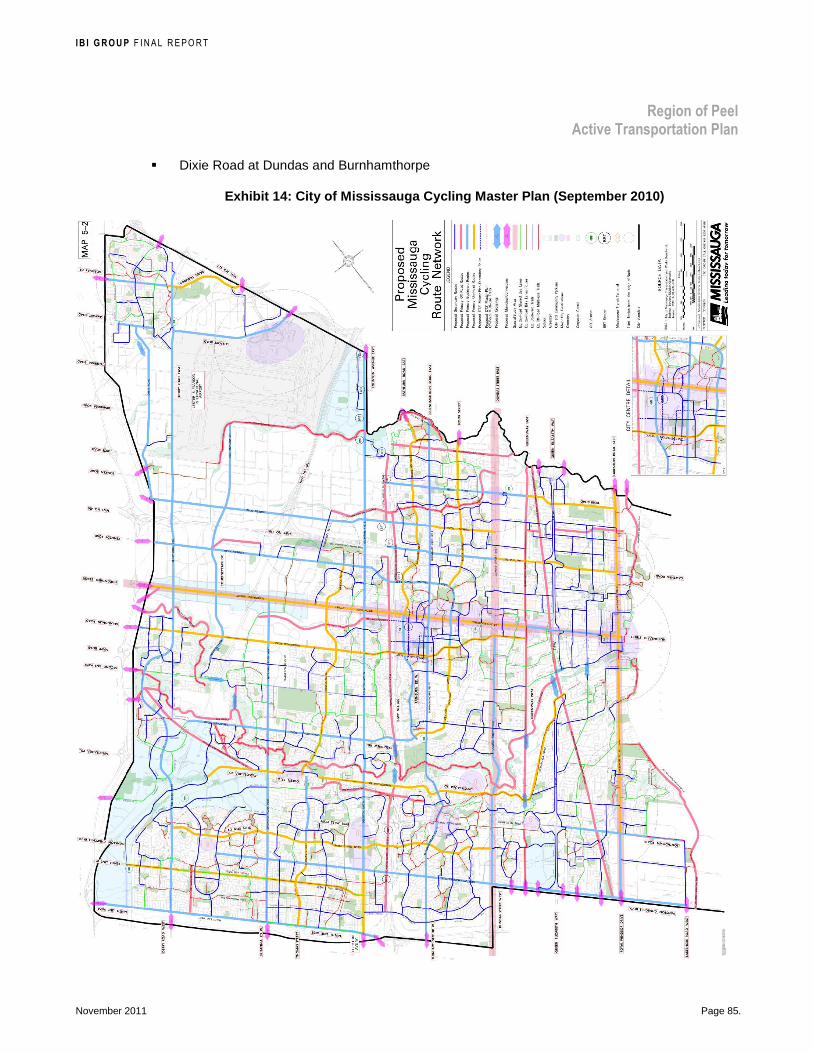
I B I G R O U P F INAL REPORT
Region of Peel Active Transportation Plan
November 2011 Page 85.
� Dixie Road at Dundas and Burnhamthorpe
Exhibit 14: City of Mississauga Cycling Master Plan (September 2010)

I B I G R O U P F INAL REPORT
Region of Peel Active Transportation Plan
November 2011 Page 86.
7.3 Context
7.3.1 Existing and Planned Land Use From 2001 to 2031, the population and employment figures for the Region of Peel are expected to grow from 989,000 to 1.4 million and from 534,000 to 875,000, respectively. Map 4 illustrates land use. In Mississauga, most of the land is already developed and/or designated; therefore the growth pattern shows a plateau pattern where further growth is based on intensification. The largest growth and most aggressive expansion are planned in Brampton. Caledon’s population and employment forecasts are low in comparison, yet aggressive in terms of doubling current levels with a focus on modest expansion of existing communities. The schedules define growth areas and urban growth centres, greenfield expansion areas, intensification and major transit corridors, and mobility hubs.
Active transportation responds to land-use. As with any mode of transportation, it is the interaction of people with places, and the supply of services and goods that motivates travel. The presence and proximity of developments including residential, commercial, employment, and institutional affects the trip mode. Most of the developed areas in the Region of Peel should be included in the active transportation network, with the potential to generate short trips under 5 km or less possible on foot or by bicycle.
Exhibit 15: Population and Employment Forecasts for Area Municipalities in the Region of Peel
0
50,000
100,000
150,000
200,000
250,000
300,000
350,000
400,000
450,000
500,000
0
100,000
200,000
300,000
400,000
500,000
600,000
700,000
800,000
900,000
1,000,000
2001 2011 2021 2031
Em
plo
ym
en
t
Po
pu
lati
on
Year
Caledon (Pop) Brampton (Pop) Mississauga (Pop) Caledon (Emp) Brampton (Emp) Mississauga (Emp)
A research paper examining walking and cycling distances in Montréal12 consider population density and mode share. For Montréal region, as illustrated in Exhibit 16 “there is a relationship between density of inhabitants and walking and cycling, with a few notable exceptions. There is as great a
12 Larsen, J., A. El-Geneidy and F. Yasmin, “Beyond the quarter mile: Re-examining travel distances by active transportation”, Canadian Journal of Urban Research: Canadian Planning and Policy (supplement), 19(1), 2010, pp. 70-88.

I B I G R O U P F INAL REPORT
Region of Peel Active Transportation Plan
November 2011 Page 87.
share of walking trips originating in the central business district (CBD) as in the inner ring, yet a lower residential density than the inner ring; this is likely due to the density of destinations, which contribute to a high walk share. As observed from [Exhibit 16] the CBD and the inner ring had the highest distances traveled by walking and cycling in term of median distances. Likewise, at the periphery, while residential density decreases between outer ring suburbs and the regional ring, walking and cycling rates increase in this area. ... This finding lends weight to research that suggests that other factors such as land use mix, urban form and residential self-selection may partly explain walking and cycling patterns.”
In comparison, Caledon’s, Brampton’s and Mississauga’s population densities in 2031 are projected to be around 130 person/km2, 2600 persons/km2 and 2500 person/km2, respectively. The current mode share for walking and cycling are 3.3% and 0.2% in Caledon, 5.3% and 0.3% in Brampton and 4.9% and 0.3% in Mississauga respectively. In comparison to the Montréal data, it would appear that the projected population densities could support more walking and cycling than currently occurs.
Exhibit 16: Population Density and Walking / Cyclin g Mode Share in Different Parts of the Montréal Region
7.3.2 Transit and Mobility Hubs All transit trips begin or end with walking, even if just a short distance to or from a transit stop or station. Cycling can also be integrated into transit trips at the beginning or end, or both if the bicycle is accommodated on the transit vehicle. Good connection to transit corridors and nodes is an important consideration when developing a comprehensive active transportation network. Map 5 shows existing and proposed transit in the Region of Peel.
Several transit agencies operate within the Region of Peel: Brampton Transit, Mississauga Transit and GO Transit. Brampton and Mississauga Transit provide local bus service to serve public transportation needs within their respective municipalities. Caledon contracts service from
I B I G R O U P F INAL REPORT
Region of Peel Active Transportation Plan
November 2011 Page 88.
Brampton Transit. GO Transit provides inter-regional bus and rail service for the Greater Toronto Area.
Higher-order transit service is being implemented in Brampton (Züm) and Mississauga (MiWay). Brampton Transit’s Züm is a Bus Rapid Transit (BRT) to serve longer distance trips. The first Züm route, launched September 2010, runs along Queen Street from downtown Brampton to York University. Future routes are planned for Main Street from Sandalwood Road to Square One in 2011, Steeles Avenue from Shopper’s World to Humber College in 201213 and along Bovaird from Mount Pleasant GO station to Airport Road in 2014. The Mississauga Transit’s MiWay BRT route is planned to run from Winston Churchill Boulevard to Renforth along Highway 403, Eastgate Parkway and Eglinton Avenue, to be completed at the end of 201214.
In the Region of Peel, GO Transit stations are located along three GO train lines15. GO-Metrolinx supports the improvement of pedestrian and cycling amenities at GO stations. According to the GO Transit Station Access Strategy, two guiding principles are:
� Prioritize access by pedestrian, cyclist and local transit to all GO stations; and
� Improve integration, convenience and continuity of walking and cycling routes in areas surrounding stations.
The Metrolinx Regional Transportation Master Plan (The Big Move, 2008) identified 51 mobility hubs within the Greater Toronto and Hamilton Area (GTHA): three in Brampton (Bramalea GO, Downtown Brampton, Hurontario – Steeles) and four in Mississauga (Cooksville GO, Mississauga City Centre, Pearson Airport, and Port Credit GO). These mobility hubs are defined as “major transit station areas that are particularly significant given the level of transit service that is planned for them and the development potential around them. They are places of connectivity between regional rapid transit services, and also places where different modes of transportation, from walking to high-speed rail, come together seamlessly. They have, or are planned to have an attractive, intensive concentration of employment, living, shopping and enjoyment around a major
transit station. ...These areas are generally forecasted to achieve or have the potential to achieve a minimum density of approximately 10,000 people and jobs within an 800 metre radius”16.
Where possible, it is recommended that the Regional active transportation network connect or integrate with ex isting and planned transit services, stops and stations.
7.3.3 Physical Barriers Major physical barriers to an active transportation network in the Region of Peel, including freeways, railways and waterways are illustrated on Map 6.
Freeway Crossings
The prevalence of freeways in the transportation network presents a challenge for pedestrians and cyclist due to the limited number of crossings (and corresponding distance between crossings), the
13 http://www.brampton.ca/en/residents/transit/zum/Documents/Phase1Map.pdf, October, 2010 http://www.brampton.ca/en/residents/transit/zum/Documents/Phase2Map.pdf, October, 2010 14 http://www.mississauga.ca/portal/miway/brtbasics?paf_gear_id=9700018&itemId=102500707n, October, 2010 15 http://www.gotransit.com/publicroot/en/schedules/lstser.aspx?New=, October, 2010 16 http://www.metrolinx.com/mx/thebigmove/en/glossary/index.aspx, February 2011
AT Plan Recommendation: Where possible, connect or integrate the Regional active transportation network with existing and planned transit services, stops and stations

I B I G R O U P F INAL REPORT
Region of Peel Active Transportation Plan
November 2011 Page 89.
high speed and volume of traffic at the interchanges, and the general lack of or poorly designed pedestrian and bikeway facilities at these locations. Of the fifty-five crossings of freeways in the Region of Peel, 44 are interchanges, nine are road overpasses and two are road underpasses. Grade-separated crossings (bridges or tunnels) of freeways for pedestrians and cyclists are preferred treatments as they limit the conflict points between higher speed traffic and pedestrians and cyclists. Crossings that accommodate active transportation only are as follows: Caledon Trailway over Hwy. 10, Etobicoke Creek trail under Hwy. 410 in Brampton (proposed), Culham Trail under Hwy. 403 in Mississauga, Insley / Ogden pedestrian connection over the QEW, and Etobicoke Creek Trail under Highway 401 in Mississauga.
Goods Movement / Trucks
Another barrier to vulnerable road users (pedestrians and cyclists) on Regional roads is high truck volumes, which are common along Regional roads primarily in the employment lands near the Toronto Pearson International Airport. In Mississauga, almost all Regional roads, except Winston Churchill Boulevard and sections of the Queensway, have no restrictions on truck traffic. The pattern in Brampton is similar to Mississauga; however more restrictions exist on Regional roads through residential areas. In Caledon, truck routes are limited to several rural Regional roads. Truck volumes are very heavy, exceeding 800 trucks an hour, on Bovaird Drive at Kennedy Road, Steeles Avenue between Kennedy Road and Hwy. 50, Derry Road between Hwy. 401 and Airport Road, Dixie between Steeles Avenue and Hwys. 401 / 403, Airport Road between Queen Street and Pearson Airport, and Hwy. 50 north of Queen Street. As Peel plans to enhance its role as a major goods movement hub, it is important to consider growing truck volumes and its impact on the comfort and safety of vulnerable users who still have a need to access destinations along these corridors. Active transportation facilities that provide separated space are required within goods movement corridors, along with design features to improve the safety and comfort of all road users at intersections, as outlined in Section 8.5, Policy Recommendations for New Design Strategies, page 127.
Waterways
Valleylands along waterways often provide opportunities to create linear trail systems. However, the waterways can also be barriers to transportation with limited locations where they can be crossed.
In Caledon, the Credit River, Humber River and Etobicoke Creek are predominantly crossed by Regional roads and some local roads. The Caledon Trailway follows along sections and crosses the Credit River and Humber River. In Brampton, the waterways have been the primary focus for their pathways system, both existing and planned, with crossing opportunities by path, and local and Regional roads. These waterways include the Credit River, Etobicoke Creek and Humber River. In Mississauga, the Credit River is prominent, plus the Etobicoke Creek traverses a section of the City. Trails exist or are planned along both. Although local and Regional roads cross these waterways, a long section of the Credit River, between Dundas Street and Lakeshore Road has no crossings accessible to pedestrians and cyclists.
Railways
Three mainline railways traverse the Region of Peel: National (CN) / Canadian Pacific Railway (CPR) / GO Transit (GO) mainline north of Lake Ontario through Mississauga; Canadian Pacific Railway (CPR) / GO Transit (GO) mainline through Mississauga; and Canadian National (CN) / GO Transit (GO) mainline through Mississauga and Brampton. There is also the Canadian National (CN) / GO Transit (GO) collector and primary feeder in Brampton, and the Orangeville Brampton Railway (OBRY) collector and primary feeder from Mississauga northerly through Brampton and

I B I G R O U P F INAL REPORT
Region of Peel Active Transportation Plan
November 2011 Page 90.
Caledon. Opportunities to cross these railways are predominantly provided by Regional roads and local arterial roads.
7.3.4 Destinations Key destinations that residents and visitors to the Region of Peel desire access to are illustrated on Map 7. Destinations mapped, over and above residential and employment lands shown on the land-use map, include schools (elementary to post secondary), shopping centres and parkland. To encourage people to use active modes, the network needs to link people to their destinations, both existing and within new development areas.
Connecting active residents and visitors to sports centres can be a focus of event planning. The upcoming 2015 Pan Am games is an example with four venues in the Region of Peel: Powerade Centre, Brampton; and Iceland Mississauga, Hershey Centre, Classic Bowl, Mississauga.
The Region of Peel operates a carpool lots at Mayfield Road and Highway 50. Active transportation connections to this lot should be encouraged to increase longer, linked walking / bicycling with carpool trips.
Adjacent AT Networks
In planning for active transportation, the Region of Peel has a role to co-ordinate and integrate the network with those of adjacent municipalities. Adjacent pedestrian and cycling networks can help identify possible gateways to neighbouring communities by emphasizing continuity and consistency of AT facilities where Regional roads or trails connect to existing or planned routes. It may also firm-up partnerships in the planning and construction of pedestrian and cycling facilities. Maps of the existing and proposed AT networks for adjacent municipalities are available in Appendix B.
To the west, Halton Region has identified a conceptual regional cycling and pathways network in their Transportation Master Plan (2004). Regional roads identified for potential on-road cycling facilities are Britannia Road, Steeles Avenue, and Embleton Road (5 Sideroad). More specifically, paved shoulders are proposed along Britannia Road, Derry Road by the Town of Milton Trails Master Plan Update (Approved September 2007); along Steeles Avenue, Embleton Road (5 Sideroad) and Bovaird Drive (Guelph Street) by the Town of Halton Hills Cycling Master Plan (2010). The Oakville AT Master Plan (2009) shows a proposed multi-use trail designated along Winston Churchill Boulevard from Lakeshore Road to Dundas Street.
Halton Region has initiated an update to the master plan: Transportation Master Plan (TMP) - The Road to Change to develop a sustainable, integrated transportation plan and associated strategies that consider all modes of travel (automobiles, transit, cycling, walking) to the year 2031.
To the north, off-road trails are planned at the connecting portion of Porterfield Road according to the Dufferin County Trails and Active Transportation Master Plan (2010).
To the East, the York Region Pedestrian & Cycling Master Plan (2008) shows proposed paved shoulders on King Road (which connect to King Street East) and proposed bike lanes on Highway 7 (which connects to Queen Street). No sidewalks are planned along Regional roads near the Peel border. The City of Vaughan Pedestrian and Bicycle Master plan (2007) aligns with the Regional network. The Toronto Bike Plan (2001) proposes bike lane at Steeles Avenue and Dixon Road (to Airport Road).

I B I G R O U P F INAL REPORT
Region of Peel Active Transportation Plan
November 2011 Page 91.
Wellington County and Simcoe County currently do not have a published map network of planned active transportation routes or infrastructure.
7.3.5 Density of Short Trips and Pedestrian Demand The density of short trips based on data from the Transportation Tomorrow Survey 2006 and an estimate of pedestrian demand along Regional roads are illustrated on Map 8.
The density of short trips by all travel modes (car driver or passenger, transit, walking, cycling) that are shorter than 1 km, a reasonable trip length on foot, and shorter than 5 km, a reasonable trip length by bicycle, are illustrated on Maps 8. Each “dot” on the map represents 100 daily school or work short trips in that traffic zone.
An estimate of Regional roads with potential for high pedestrian demand was prepared based on a linear combination of the following data:
� The density of work and school trips less than 1 km long;
� 2006 population and employment densities; and
� The pedestrian routing along streets within 400 to 800 m (or a 5 to 10 min. walk) of various destinations / land uses (banks, theatres, coffee shops, convenience stores, grocery stores, restaurants, shopping centres, other retail, GO Transit stations, hospitals, community centres, large offices, parks, parking lots, elementary and high schools, and colleges / universities)
The resulting index was segmented from low to high potential pedestrian demand along Regional roads. Although the basic need of pedestrians should be provided for along all Reg ional roads in developed areas, it is recommended that additional enhancements to the pedestrian environment be implemented in are as where there is a high potential for walking trips to enti ce more people to walk for short trips.
7.4 Active Transportation Network Strategies During the process of developing the active transportation network, input and feedback was received from various Regional and local municipal staff, agencies, stakeholders and members of the general public. Alternative strategies in each community were considered based on general and detailed comments. These are discussed below. Detailed tables describing the active transportation infrastructure for each section of Regional road are provided in Appendix C.
Over-arching strategies for active transportation infrastructure on Regional roads based on design guidance are as follows:
AT Plan Recommendation: Although the basic need of pedestrians should be provided for along all Regional roads in developed areas, implement additional enhancements to the pedestrian environment in areas where there is a high potential for walking trips to entice more people to walk for short trips.

I B I G R O U P F INAL REPORT
Region of Peel Active Transportation Plan
November 2011 Page 92.
� Splash strips are not considered part of the active transportation infrastructure. Their width of 1.0 m is not sufficient and their design at intersections is completely lacking to adequately accommodate active transportation modes.
Sidewalks (or multi-use trails) should be located on both sides of all Regional roads within existing or future developed areas. The option of multi use trails on both sides is preferred to accommodate pedestrians, cyclists and other active transportation users where on-road bikeways are not provided. The feasibility of this design strategy requires further discussion, as presented in Section 8.5, Policy Recommendations for New Design Strategies, page 127.
� Due to safety issues with higher speed trail users and right-of-way at driveways and side streets, boulevard multi-use trails should only be implemented along roadways where there is no more than one driveway or side street intersections every 300 m. Options such as bike lanes and segregated bikes should be considered in these areas.
� Paved shoulders should be provided on all rural Regional roads where a structurally adequate sub-base can be provided. Maintenance costs will reduce, run-off-the-road single vehicle collisions will decrease, and cyclists will benefit from space outside the general purpose travel lane on these high speed, high volume roads. Existing paved shoulders separated by a pavement marking lane line or mountable curb and gutter are often used by pedestrians in rural settlements. This is an acceptable use; however, fully accessible sidewalks on both sides of the road in rural communities with an existing or proposed urban cross section should be implemented when construction opportunities arise. Bike lanes in these areas would provide for continuity of the paved shoulder.
The above design strategies are discussed in greater detail in Section 8.5, Policy Recommendations for New Design Strategies, page 127.
Linking the Regional and local active transportation networks along public rights-of-way to private developments is important to connect users directly to their destinations, i.e. the entrances to buildings. The Region and area municipalities can support the development of sites that are accessible to pedestrians and cyclists through the development application process. This is discussed in greater detail in Section 8.11, Site Design for Active Transportation, page 155.
7.4.1 Caledon The recommended pedestrian network strategy in Cale don is as follows:
� Provide accessible sidewalks on both sides of Regional roads within the existing settlement areas and planned development by filling in the gaps in the existing sidewalk system.
� In some communities where a key destination such as a school, community centre or service lies just outside a settlement area, extend the sidewalk on one side of the Regional road to that single destination.
� Where splash strips or paved shoulders currently accommodate pedestrians in settlement areas, upgrade to fully accessible sidewalks in the long term as rural Regional roads are urbanized.

I B I G R O U P F INAL REPORT
Region of Peel Active Transportation Plan
November 2011 Page 93.
� Enhance the pedestrian experience in Bolton on Queen Street south of King Street to the railway through the provision of amenities such as landscaping, shade, rest areas, etc.
The recommended cycling network in Caledon incorporates the following:
� Take advantage of capital projects to implement paved shoulders on all rural Regional roads where feasible (e.g. a structurally adequate sub-base can be provided without negatively impact adjacent environment).
� Where steep terrain or environmentally sensitive lands constrain the width of the rural Regional road, provide shared-use lane markings if the operating speed is 60 km/h or less, and provide “Share the Road” signage.
� Undertake policy discussions at future opportunities for their potential implementation or when other planning studies arise regarding providing bike lanes as a continuation of paved shoulders in settlement areas when the Regional roads are urbanized.
Common to both the pedestrian and cycling networks are recommended trail improvements . These include:
� Extend the Etobicoke Creek Trail farther north into the Town of Caledon (mapping of alignment pending).
� Improve the safety and visibility of the Caledon Trailway crossings of Regional roads. Increasing the visibility of the crossing to motorists and trail users is important along with techniques to reduce speeds and exposure can be applied on a site-by-site basis. Design strategies for crossings are documented in Section 8.6, Crossings and Intersections, page 133.
The recommended pedestrian and cycling networks along Regional roads in the Town of Caledon are illustrated on Maps 9a and 10a. A total of approximately 27 km of sidewalks, 11 km of multi-use trails, 138 km of paved shoulders, 19 km of bike lanes, 12 km of marked shared-use lanes, improvements to 7 trail crossings, and 1 km of pedestrian enhancements are recommended.
AT Plan Recommendation—Caledon Pedestrian and Cycling Network Strategy: � Provide sidewalks on both sides of
Regional roads in settlement / development areas
� Extend sidewalks on one side of Regional roads to key destinations
� Upgrade splash strips / paved shoulders to sidewalks and potentially bike lanes, if feasible, in settlement areas when rural Regional roads are urbanized
� Provide pedestrian enhancements in Bolton
� Implement paved shoulder on rural Regional roads where feasible
� Where steep terrain or environmentally sensitive lands constrain the width of the rural Regional road, provide shared-use lane markings (speed 60 km/h or less), and “Share the Road” signage
� Extend the Etobicoke Creek trail farther north
� Improve the safety and visibility of the Caledon Trailway crossings of Regional roads

I B I G R O U P F INAL REPORT
Region of Peel Active Transportation Plan
November 2011 Page 94.
7.4.2 Brampton Three active transportation network strategies are considered for Regional roads in Brampton.
The first considered a vision of creating a more comfortable network viable for a wide range of users, their experiences and skills. In particular, the early vision for the cycling network was to create one that would improve the travel quality for experienced cyclists through enhanced function, but also attract new users through enhanced comfort. However, this vision could only come to fruition with a complete re-thinking of the character of Regional roads. A substantial increase in walking and cycling trips would result. However, current Regional road conditions and planning efforts to meet automobile travel trends result in heavily travelled wide roads and even wider intersections. Combined with high posted and design speeds, the environment along Regional roads is uncomfortable, and considered unsafe for vulnerable users such as pedestrians and cyclists. Without a re-thinking, incorporating such facilities as bike lanes, segregated or not, and significant improvements so pedestrians can cross these roads seem inappropriate.
The second iteration of the active transportation network considered increasing accessibility for pedestrians and cyclists generally throughout Brampton within the context of the existing and planned six-lane Regional roads. This strategy consisted of the following:
� A short term vision of filling the remaining gaps in the existing sidewalk and multi-use trail network along Region roads.
� A short to medium term vision of providing multi-use trails on both sides of Regional roads where development exists or is planned on both sides to improve accessibility for cyclists. Cyclists are forced to ride on sidewalks or along splash strips, or to cross the roads mid-block in areas currently served by a multi-use trails on one side of the road when their destinations are located on the other side. In some cases existing sidewalks would be replaced in the long term by multi-use trails.
� A long term vision of high quality, both in function and comfort, segregated bike lanes on Queen Street with the advancement of high-order transit, and along Regional roads in the growth areas on the west side of the Brampton
Following consultation with the Steering Committee, agencies and stakeholders, the third and recommended strategy for the active transportation network in Brampton , to integrate the City’s PathWay system with destinations along Regional roads, is as follows:
� On Regional roads that will be widened or reconstructed according to the Capital Improvement Program for the next 20 years, provide a sidewalk on one side and a multi-use trail on the other side.
� Fill in the gaps in the existing sidewalk and multi-use trail network along Regional roads that are fully built out.
� Enhance the pedestrian experience along some sections of Bovaird Drive, Queen Street Steeles Avenue, Kennedy Road and Dixie Road through the provision of amenities such as landscaping, shade, rest areas, etc.

I B I G R O U P F INAL REPORT
Region of Peel Active Transportation Plan
November 2011 Page 95.
� Assist the City of Brampton in collaborating with the Ministry of Transportation, Ontario in improving freeway crossings, and seeking opportunities to build grade-separated pedestrian / cycling crossings where the frequency of roadway crossings and improvement alternatives are limited.
� Include the east-west pathway along the hydro corridor south of Highway 407 from the City’s western boundary, crossing the freeway to the Claireville Conservation Area. This trail provides a connection across the entire City and will require multiple partners to implement.
� Undertake policy discussions at future opportunities for their potential implementation or when other planning studies arise regarding the following new design strategies:
– Segregated bike lanes along some sections of Queen Street and Mississauga Road where future pedestrian-oriented development, intensification or higher-order transit is being planned. Note that a narrow section of Queen Street with fronting development east of McLaughlin would have conventional bike lanes compatible with the business district to the east.
– Where feasible, providing multi-use trails on both sides to provide access to developments on both sides of the road where on-road bikeways are not present / planned.
– Replacing sidewalks that require reconstruction in the long term with multi-use trails where on-road bikeways are not present / planned.
The recommended pedestrian and cycling networks along Regional roads in the City of Brampton are illustrated on Maps 9b and 10b. A total of approximately 80 km of sidewalks, 148 km of multi-use trails, 4 km of bike lanes, 12 km of segregated bike lanes, improvements to 9 interchanges and 20 km of pedestrian enhancements are recommended.
AT Plan Recommendation—Brampton Pedestrian and Cycling Network Strategy: � Provide a sidewalk on one side
and a multi-use trail on the other side of Regional roads in 20-year Capital Improvement Program
� Fill in the gaps in the existing sidewalk and multi-use trail network along Regional roads that are fully built out
� Provide pedestrian enhancements along some sections of Bovaird Drive, Queen Street Steeles Avenue, Kennedy Road and Dixie Road
� Undertake future policy discussions on new design strategies: – Potentially segregated bike
lanes along sections of Queen Street and Mississauga Road
– Where feasible, potentially multi-use trails on both sides of Regional roads
– Potentially replace sidewalks that require reconstruction in the long term with multi-use trails

I B I G R O U P F INAL REPORT
Region of Peel Active Transportation Plan
November 2011 Page 96.
7.4.3 Mississauga Similar to Brampton, there was an initial desire to create a more comfortable network viable for a wide range of users, their experiences and skills. In particular, the early vision for the cycling network was to create one that would improve the travel quality for experienced cyclists through enhanced function, but also attract new users through enhanced comfort. This vision could only come to fruition with a complete re-thinking of the character of Regional roads. A substantial increase in walking and cycling trips would result. However, in Mississauga, most of the Regional roads are fully built-out to six lanes wide with high traffic volumes. Combined with relatively high speeds, the environment along Regional roads is uncomfortable, and considered unsafe for vulnerable users such as pedestrians and cyclists. There are very few construction opportunities for Regional roads in Mississauga.
Recognizing the built-out form of Regional roads, the recommended strategy for developing a pedestrian and cycling ne twork in Mississauga , to integrate the City’s cycling network with destinations along Regional roads, is as follows:
� Fill in the gaps in the existing sidewalk and multi-use trail network along Regional roads that are fully built out.
� Consider special active transportation facility designs where routes intersect with nodes identified in the City of Mississauga’s Official Plan, that is:
– Erin Mills Parkway at Queensway, Burnhamthorpe and Eglinton
– Dixie Road at Dundas and Burnhamthorpe
� Enhance the pedestrian experience along some sections of Derry Road, Britannia Road, the Queensway, Cawthra Road and Dixie Road through the provision of amenities such as landscaping, shade, rest areas, pedestrian lighting etc.
� Assist the City of Mississauga in collaborating with the Ministry of Transportation, Ontario in improving freeway crossings, and seeking opportunities to build grade-separated pedestrian / cycling crossings where the
frequency of roadway crossings and improvement alternatives are limited.
� Include the east-west pathways along the hydro corridors south of the QEW crossing the Credit River, and south of Highway 403. These trails span a significant portion of the City and will require multiple partners to implement.
� Collaborate with the City of Mississauga in developing pedestrian / cycling crossings of the Credit River partway between the Queensway and Lake Ontario.
AT Plan Recommendation—Mississauga Pedestrian and Cycling Network Strategy: � Fill in the gaps in the existing
sidewalk and multi-use trail network along Regional roads that are fully built out.
� Consider special AT facility designs where routes intersect with nodes identified in the City of Mississauga’s Official Plan, that is: – Erin Mills Parkway at
Queensway, Burnhamthorpe and Eglinton
– Dixie Road at Dundas and Burnhamthorpe
� Provide pedestrian enhancements along some sections of Derry Road, Britannia Road, the Queensway, Cawthra Road and Dixie Road
� Assist the City in collaborating with MTO on improving freeway crossings, and seek opportunities to build pedestrian / cycling crossings where the frequency of alternatives are limited
� With multiple partners, implement the pathways along the hydro corridors south of the QEW and south of Highway 403
� Collaborate with the City in developing pedestrian / cycling crossings of the Credit River between the Queensway and Lake Ontario
Continued on next page.

I B I G R O U P F INAL REPORT
Region of Peel Active Transportation Plan
November 2011 Page 97.
� Undertake policy discussions at future opportunities for their potential implementation or when other planning studies arise regarding the following new design strategies:
– The potential for bike lanes or segregated bike lanes along some sections of Cawthra Road where numerous driveways may preclude the development of a multi-use trail in the boulevard due to safety concerns.
– Where feasible, providing multi-use trails on both sides to provide access to developments on both sides of the road where on-road bikeways are not present / planned.
– Replacing sidewalks that require reconstruction in the long term with multi-use trails where on-road bikeways are not present / planned.
The recommended pedestrian and cycling networks along Regional roads in the City of Mississauga are illustrated on Maps 9c and 10c.
The following differences are noted between the recommendations of the Region of Peel Active Transportation Plan and the City of Mississauga Cycling Master Plan:
� Dixie Road from the future BRT station north to the City limits is proposed as a multi-use trail in this plan to provide access to the adjacent employment lands. No bikeway is proposed on this section of Dixie Road in Mississauga’s Cycling Master Plan.
� Erin Mills Parkway from the QEW north to the City limits is proposed as a multi-use trail in this plan to provide access to the adjacent residential land uses, and community and major nodes located along this corridor. No bikeway is proposed on Erin Mills Parkway in Mississauga’s Cycling Master Plan.
� Winston Churchill Boulevard from Lakeshore Road to Royal Windsor Drive is included in the Region’s capital project as a paved shoulder in the short-term and as a multi-use trail in the long term. Mississauga’s Cycling Master Plan identifies a multi-use trail along this location of roadway.
Note that the City of Mississauga’s Capital Funding for the Cycling Program does not include those facilities above not identified in their Cycling Master Plan. Consideration will be given to adding these routes when the City’s Cycling Master Plan undergoes its 5-year review. A total of approximately 27 km of sidewalks, 107 km of multi-use trails, 5 km of bike lanes, improvements to 9 interchanges, 4 new trail crossings, and 14 km of pedestrian enhancements are recommended.
AT Plan Recommendation—Mississauga Pedestrian and Cycling Network Strategy (continued): � Undertake future policy
discussions on new design strategies: – Potentially bike lanes or
segregated bike lanes along sections of Cawthra Road
– Where feasible, potentially multi-use trails on both sides of Regional roads
– Potentially replace sidewalks that require reconstruction in the long term with multi-use trails

I B I G R O U P F INAL REPORT
Region of Peel Active Transportation Plan
November 2011
8 ACTIVE TRANSPORTATION FACILITIES REFERENCE GUIDE
Active transportation infrastructure includes a number of different types of facilities to accommodate the wide range of abilities, skills and experience of pedestrians, in-line skaters, cyclists, pedestrians with mobility devices, visual, hearing or cognitive impairments, skateboarders, etc. The basic facilities on which they travel consist of: sidewalks for pedestrians, child cyclists and small-wheeled users like in-line skaters and skate-boarders; multi-use trails that essentially accommodate all active transportation modes; and bikeways such as bike lanes for cyclists only. General design guidance is provided in this chapter and is based on current design guidelines available in North America. Design guidelines in use by local municipalities are also presented.
The intent of this section is to provide an overview of existing active transportation facilities that being implemented on Peel Regional roads: sidewalks and boulevard multi-use trails. Also, the section will introduce active transportation faculties that are currently not in use in on Regional roads. It is recommended, as presented in Section 5.2.3, Design for Active Transportation on the Regional Roads in Balance with the Needs of Other Modes, page 51, that policy discussions consider these new design strategies as opportunities arise including:
� Providing multi-use boulevard trails on both sides of Regional Roads,
� Replacing deteriorated sidewalks with multi-use boulevard trails on one or both sides of Regional Roads
� Designing segregated bike lanes along Regional road intensification corridors and higher-order transit corridors
� Constructing sidewalks and bike lanes on Regional roads in rural communities
� Retrofitting bike lanes or segregated bike lanes where boulevard trails are not appropriate
Every corridor is unique and the design for each corridor should be custom-made to fit the context of the social, environmental and economic conditions. The decision to implement these new concepts depends on revising current practice through policy discussions and site-specific assessments.
This section also introduces concepts for improving intersections to better accommodate pedestrians and cyclists balanced with the needs of all modes; and end-of-trip facilities to support users.

I B I G R O U P F INAL REPORT
Region of Peel Active Transportation Plan
November 2011 Page 99.
As presented in Section 7.1, Active Transportation Network: Approach, page 75, in general, roads under the jurisdiction of the Region of Peel are multi-lane, higher speed, widely spaced arterial roadways and have been built or are planned to accommodate the mobility of motorists and commercial vehicles. This presents a challenge in that the space required to accommodate these regional transportation needs necessitates a wider Right-of-Way (ROW). While there is a temptation to simply increase the width of the ROW to accommodate active transportation needs, this approach should be avoided. Increasing Regional road rights-of-way beyond 45 m (typical Regional road ROW width) will only serve to increase the separation of activities within a corridor and reduce the percentage of the ROW which is dedicated to non-motorized transportation. It is recommended that the proposed active transportation facilities be provided within the existing / planned Regional road rights-of-way widths (no addi tional width required) . Future policy discussions on design strategies will need to consider the active transportation requirements within the context of
other evolving roadway strategies such as lane widths, higher-order transit strategies, intersection innovations, transportation demand strategies, etc. At intersections, design strategies to improve the comfort and safety for cyclists and ped estrians need to be considered not only to improve access to AT facilities on Regional road s but also for local AT facilities intersecting Regional roads.
8.1 Local Typology The various types of active transportation facilities as defined by the local municipalities are presented in Exhibit 17, along with the terminology that will be used within the report.
Exhibit 17: Local Municipal Active Transportation F acilities and Classifications
Town of Caledon
Primary Secondary Tertiary
Urban Pedestrian Ways Sidewalks Walkways and Paths Rural Trails Trailways Hiking Trails Spurs, loops & special
purpose trails On-road Bicycle Facility Bicycle Lanes Signed Bicycle Routes
City of Brampton
Class 1: Multi-Use Path Class 2: Bike Lane Class 3: Signed Route
City of Mississauga
Multi-Use Trail: � Multi-use Trail � Off-road routes in Hydro corridors, parks and river
valleys
On-Road Routes: � Signed Routes � Bicycle Lane � Separated Bicycle Lane: One-way and two-way � Shared Use Lane (Sharrow)
� Primary routes—provide continuous connections to nodes and major destinations and can be either multi-use trails in the boulevard, on-road bike lanes or shared-use lanes
� Secondary routes—provide local connection and are likely to be in the form of on-road bicycle lanes, shared-use lanes or signed routes
AT Plan Recommendation: Provide proposed active transportation facilities within the existing / planned Regional road rights-of-way widths to limit the separation between activities within these corridors (no additional width required). At intersections, design strategies to improve the comfort and safety for cyclists and pedestrians need to be considered not only to improve access to AT facilities on Regional roads but also for local AT facilities intersecting Regional roads.

I B I G R O U P F INAL REPORT
Region of Peel Active Transportation Plan
November 2011 Page 100.
Active Transportation Facilities Applicable to Regional Roads
Type Current Practice Simplified Application
Criteria Equivalents to area municipal
classification
Sidewalk Yes on most urbanized Peel Regional roads
Both sides of all roads within developed areas
� Caledon’s Primary Urban Pedestrian Way (sidewalk)
Boulevard Multi-use Trail
Yes on most urbanized Peel Regional roads typically on one side only
Where less than one intersection / driveway every 300 m
� Caledon’s Primary Rural Trail (trailway)
� Brampton’s Class 1 Multi-use Path � Mississauga’s Multi-use Trail
Paved Shoulder Yes on some rural Peel Regional roads
Width increases as volume / speed increases
� Caledon’s Primary On-road Bicycle Facility (bicycle lanes)
Marked Shared-use Lanes (Sharrows)
No > 5,000 vpd and < 60 km/h
� Caledon’s Secondary On-road Bicycle Facility (signed bicycle routes)
� Mississauga’s Shared Use Lane (Sharrow)
Bicycle Lane No > 5,000 vpd and > 40 km/h and ≤ 60 km/h
� Caledon’s Primary On-road Bicycle Facility (bicycle lanes)
� Brampton’s Class 2 Bicycle Lane � Mississauga’s Bicycle Lane
Segregated Bicycle Lane
No > 10,000 vpd and > 40 km/h
� Mississauga’s Separated Bicycle Lane: one-way
Splash or Maintenance Strips
Asphalt splash or maintenance strips typically 1.0 m wide are provided along the back of the curb on Regional roads to accommodate road and winter maintenance (snow storage). Although often used by pedestrians and cyclists when sidewalks, multi-use trails or bikeways are not present, splash strips should NOT be considered part of the active transportation infrastructure . Their width of 1.0 m is not sufficient and their design at intersections is completely lacking to adequately accommodate active transportation and pedestrians with disabilities.
8.2 Planning and Design Guideline References One of the recommended policies presented in Section 5.2, Additional Supportive Active Transportation Plan Policies, page 47, is to “reference and apply current and professionally supported guides for the promotion, planning, design, maintenance and operation of active transportation facilities, including any approved standards related to the Ontarians with Disabilities Act, and engineering design manuals such as MTO and TAC Guidelines, Velo Quebec’s Planning and Design for Pedestrians and Cyclists, NACTO’s Urban Bikeway Design Guide, and others as appropriate.” Recommended design guidelines for the planning and design of accessible pedestrian

I B I G R O U P F INAL REPORT
Region of Peel Active Transportation Plan
November 2011 Page 101.
facilities, accessible multi-use trails, bikeways and bicycle parking are provided below. The subsequent design criteria guidelines are based on these references.
The Ministry of Transportation, Ontario is currently undertaking a number of studies to provide guidance on active transportation on Ministry facilities, including updating their 1996 bikeway design guide, and traffic control manuals for pedestrian and bikeway devices. Any proposed improvements within MTO right-of-ways would need to meet MTO guidelines or justify other best practices.
8.2.1 Pedestrians and Cyclists Planning and Design for Pedestrians and Cyclists: A Technical Guide, Vélo Québec
Association (2010)
This is the 3rd edition of Vélo Québec’s design handbook expanded to include pedestrian design issues. As the most recently published guidelines in North America, it is a primary source for cycling and pedestrian planning and design guidance in the Canadian context. This manual summarizes the main characteristics of active transportation, discusses the design characteristics of pedestrians and cyclists, presents ideas on creating walkable and bikable environments, and has a section on planning for active transportation. The design sections cover paths and trails, walkways and bikeways in roadway corridors, ancillary elements such as lighting, signs and pavement markings, street furniture and parking, integration with transit, and maintenance and operation of pedestrian facilities and bikeways. Order on-line at http://www.velo.qc.ca/velo_quebec/amenagements.php?page=guide (January 2011).
Designing Walkable Urban Thoroughfares: A Context S ensitive Approach, Institute of Transportation Engineers (ITE), 2010
This recommended design practice of the Institute of Transportation Engineers (Washington DC) is a comprehensive guide to the planning and design of major streets in urban areas. It is comprehensive in that it includes all elements of the roadway, whether they are for motorists, pedestrians or cyclists, as they interact to influence the walkability of the corridor. Chapters in the design section include: design controls, and street-side, travel way, and intersection design guidance. Available on-line at http://www.ite.org/emodules/scriptcontent/Orders/ProductDetail.cfm?pc=RP-036A-E (January 2011).
Promoting Sustainable Transportation Through Site D esign: An ITE Recommended Practice, Institute of Transportation Engineers (IT E), 2010
This report recommends site design practices that can be applied through the site development process to promote the use of more sustainable modes of transportation, such as walking, cycling and transit. Its primary purpose is to assist policymakers and professionals involved in the preparation, review and approval of non-residential or mixed-use development proposals to identify and incorporate features that make sites more accessible to travel modes other than the single-occupant vehicle (SOV). Order on-line at http://www.ite.org/emodules/scriptcontent/Orders/ProductDetail.cfm?pc=RP-035A (February 2011)
Canadian Guide to Neighbourhood Traffic Calming , Transportation Association of Canada (TAC), 1998
A common reference for guidance on traffic calming elements such as curb extensions, refuge islands, and other devices that slow traffic and advantage pedestrians and cyclists. Although generally not applicable to arterial raodways, some of the design ideas such as curb extensions and median refuge islands have broader applciations in moderate speed environments. Order on-line at
I B I G R O U P F INAL REPORT
Region of Peel Active Transportation Plan
November 2011 Page 102.
https://vws3.primus.ca/dev.tac-atc.ca/english/bookstore/products.cfm?catid=12&subcatid=21&prodid=64 (January 2011).
8.2.2 Pedestrians Guide for the Planning, Design and Operation of Ped estrian Facilities , American
Association of State Highway and Transportation Off icials (AASHTO), 2004
This particular AASHTO guide covers characteristics of pedestrians, planning strategies, and facility design, operation, and maintenance. It is a reputable source, with a broad discussion of both planning and design issues around streets and street crossings. Order on-line at https://bookstore.transportation.org/item_details.aspx?id=119 (January 2011).
Final Proposed Accessible Built Environment Standar d, Minister of Community and Social Services, Ontario, pending
The Accessibility for Ontarians with Disabilities Act, 2005 calls on the business community, public sector, not-for-profit sector, and people with disabilities or their representatives to develop, implement and enforce mandatory accessibility standards. The Accessible Built Environment Standard provides recommendations to government on how to remove barriers in buildings and outdoor spaces for people with disabilities, inluding sidewalks and street crossings. It has been submitted to the Minister of Community and Social Services who is considering what will become law and when.
Accessible Sidewalks and Street Crossings—An Inform ational Guide, Federal Highway Administration (FHWA), 2003
The design details for U.S. accessibility legislation are contained in the Public Rights-of-Way Accessibility Guidelines (PROWAG) and this FHWA manual acts as an abridged version. Until such time that Ontario publishes thier own standrads, this guide provides a succinct summary on making sidewalk and street crossings accessible. It covers understanding users, sidewalk corridors, sidewalk grades and cross slopes, sidewalk surfaces, protruding objects, driveway crossings, curb ramps, providing information to pedestrians, accessible pedestrian signals, and pedestrian crossings. A checklist is also provided. Available on-line at http://www.bikewalk.org/pdfs/sopada_fhwa.pdf (January 2011).
Alternative Treatments for At-Grade Pedestrian Cros sings, Institute of Transportation Engineers (ITE), 2001
The report summarizes studies on pedestrian crossings and assembles in a single document the various treatments currently in use by local agencies in the U.S., Canada, Europe, New Zealand and Australia to improve crossing safety for pedestrians at locations where at-grade, marked crosswalks are provided. The report also summarizes the results of various studies conducted by public agencies on pedestrian-related collisions, including those documenting the results of removing crosswalk markings at uncontrolled locations. The appendix includes policies of specific agencies on where crosswalks are provided as well as typical crosswalk signing and striping plans. Order on-line at http://www.ite.org/emodules/scriptcontent/Orders/ProductDetail.cfm?pc=LP-629 (January 2011).

I B I G R O U P F INAL REPORT
Region of Peel Active Transportation Plan
November 2011 Page 103.
8.2.3 Bikeways Chapter 3.4—Bikeways, Geometric Design Guide for Canadian Roads ,
Transportation Association of Canada (TAC), Septemb er 1999
The TAC Geometric Design Guide provides guidance for the planning and design of roads in Canadian; however, the chapter on bikeways has not changed significantly since initial publication in 1995. Vélo Québec’s Planning and Design for Pedestrians and Cyclists, noted in Section 8.2.1, Planning and Design Guideline References: Pedestrians and Cyclists, page 101, is the preferred guideline since it is more recently updated and comprehensive. Order on-line at https://vws3.primus.ca/dev.tac-atc.ca/english/bookstore/products.cfm?catid=9&subcatid=18&prodid=54 (February 2011)
Guide for the Development of Bicycle Facilities , American Association of State Highway and Transportation Officials (AASHTO), 1999
This AASHTO guide spans planning, design, operation and maintenance of bikeways for the US. Sections include guidance for shared roadways, signed routes, bike lanes, and shared-use paths. A third edition is expected in 2011 and will be much more comprehensive, covering such topics as analysis tools, a discussion of crashes, and road retro-fitting strategies. The basic bikeway types will remain similar, with the addition of bicycle boulevards and the cautionary use of wide outside lanes due to the higher speeds they induce. Available on-line at http://safety.fhwa.dot.gov/ped_bike/docs/b_aashtobik.pdf (January 2011).
Urban Bikeway Design Guide, National Association of City Transportation Officia ls (NACTO), 2011
NACTO developed this guide as part of their Cities for Cycling initiative to provide cities with state-of-the-practice solutions to crate complete streets that are safe and enjoyable for cyclists. It includes descriptions, benefits, applications, design guidance, renderings, images and case studies for bike lanes, cycle tracks (segregated bike lanes), intersections, bicycle signals, and signing and marking. Most of the treatments are not directly referenced in the AASHTO guide or the US Manual for Uniform Traffic Control Devices. An on-line and downloadable version of the guide is available at: http://nacto.org/cities-for-cycling/design-guide/ (September 2011).
8.2.4 European Bikeways (includes Segregated Bike Lanes) The following guidelines are referenced in particular for the planning and design of segregated bike lanes, or cycle tracks, including cross-sectional criteria, side street / driveway layouts, and strategies for intersections.
Design Manual for Bicycle Traffic , Record 25, Centre for Research and Standardisation in Civil and Traffic Engineering (C ROW), 2007
Order on-line at http://www.crow.nl/shop/productDetail.aspx?id=889&category=90 (January 2011).
London Cycling Design Standards , Transport for London (TFL), 2010
Available on-line at http://www.tfl.gov.uk/businessandpartners/publications/2766.aspx (January 2011).
Collection of Cycle Concepts , Danish Road Directorate, 2000
Available on-line at http://www.vejdirektoratet.dk/pdf/cykelrapport/999Complete.pdf (January 2011).

I B I G R O U P F INAL REPORT
Region of Peel Active Transportation Plan
November 2011 Page 104.
8.2.5 Traffic Control Ontario Traffic Manual (OTM), Books 15 and 18, Ministry of Transportation , Ontario,
pending
The purpose of the Ontario Traffic Manual is to provide information and guidance for transportation practitioners and promote uniformity of treatment in the design, application and operation of traffic control devices and systems (signs, pavement markings, signals, etc.) across Ontario. The OTM is a publication made up of a series of 22 Books, which are generated over time with continuous updating planned. OTM Book 15 is a guideline on pedestrian crossing applications under development and expected to be published in 2011. OTM Book 18 is for bicycle facilities and development was initiated in 2011. Will be available on-line once published at http://www.library.mto.gov.on.ca (February 2011)
Guidelines for Understanding Use and Implementation of Accessible Pedestrian Signals, Transportation Association of Canada, 2008
These national guidelines are intended to provide deploying agencies with practical information on public liaison, accessible pedestrian signals installation prioritization and design, installation, operations and maintenance. Order on-line at https://vws3.primus.ca/dev.tac-atc.ca/english/bookstore/products.cfm?catid=12&subcatid=21&prodid=213 (February 2011)
Bikeway Traffic Control Guidelines for Canada , Transportation Association of Canada (TAC), 1998
This guide covers regulatory, warning and information signage, and pavement markings for on-road bikeways and where trails intersection roadways. It will be updated in 2011based on three TAC reports to include innovative pavement markings such as shared lane markings (“sharrows”), bicycle boxes and roundabouts. Order on-line at https://vws3.primus.ca/dev.tac-atc.ca/english/bookstore/products.cfm?catid=12&subcatid=21&prodid=63 (January 2011).
Green Lights for Bikes: Providing for bike riders a t traffic signals, Sinclair/Knight/Merz (2010)
Prepared for the State of Victoria, Australia, this report deals with material directly related to traffic signals implemented in Australia and New Zealand. It is an excellent summary of innovative approaches to signals to accommodate cyclists, including detection; start, during and clearance phasing; and other techniques such as the “green wave” synchronization for cyclists. Each traffic signal technique is described along with potential applications, benefits and disadvantages. Available on-line at http://www.bv.com.au/general/bike-futures/41329/ (January 2011).
8.2.6 Bicycle Parking Bicycle Parking Guidelines , 2nd edition, Association of Pedestrian and Bicycl e
Professionals (APBP), 2010
In the spring of 2002, the APBP published Bicycle Parking Guidelines, a basic guide to the selection and placement of bicycle racks specifically for short-term parking (available online at https://apbp.site-ym.com/?page=Publications (January 2011). This second edition updates the original guide and adds material on long-term and sheltered parking, as well as event parking, in-street bicycle parking, and bicycle transit centers. It includes sample site plans and diagrams to help avoid blunders in rack and locker placement, sample quantity requirements for bicycle parking to meet need by land use, and a worksheet for programming bicycle parking for a building or cluster

I B I G R O U P F INAL REPORT
Region of Peel Active Transportation Plan
November 2011 Page 105.
of buildings. Order on-line at https://apbp.site-ym.com/store/view_product.asp?id=502098 (January 2011).
Guidelines for the Design and Management of Bicycle Parking Facilities, City of Toronto, 2008
This is an excellent resource intended to improve the quality of bicycle parking that is secured through the development approval process. The guidelines provide planners, developers, and property managers with information to support the design, construction and management of high quality bicycle parking facilities. Although aimed at new developments, the Bicycle Parking Guidelines can also be applied to existing developments looking to improve bicycle parking facilities. Available on-line at www.toronto.ca/planning/bicycle_parking_guide.htm (January 2011).
“Installing Bicycle Parking”, City of Portland, 201 1
This web resource covers the basics of what is a good rack and a good location. The guide is intended to help property owners save money by installing bicycle parking facilities that work, whether they are required or volunteering to install bicycle parking. Note, the guide suggests that "if you see bicycles locked to trees, posts or other stationary objects nearby, you probably need bicycle parking. If you have bicycle parking that is rarely used it may be poorly located or of a type that offers little security." Available on-line at http://www.portlandonline.com/transportation/index.cfm?c=34813&a=58409 (January 2011).
8.2.7 Multi-Use Trails Ontario's Best Trails: Guidelines and Best Practice s for the Design, Construction
and Maintenance of Sustainable Trails for All Ontar ians, Trails for All Ontarians Collaborative (TAOC), 2006
The objective of the TAOC guide is to provide design guidelines for trails that protect and preserve outdoor environments that are universally designed to include people of diverse abilities. The guide provides information about trail design, construction, user amenities, signage and maintenance. Available on-line at http://www.abilitiescentre.org/trails/ (February 2011)
Trail Planning, Design and Development Guidelines , Minnesota Department of Natural Resources (MN DNR), 2006
This manual contains guidelines for creating both motorized and non-motorized trails. It is a best practices guide for government agencies or private organizations and includes sections on planning, design principles, ecological sustainability, trail classifications, shared-use paved trails, and sustainable natural trails. Order on-line at http://www.comm.media.state.mn.us/bookstore/mnbookstore.asp?page=viewbook&BookID=69276&stocknum=323 (January 2011).
Trail Intersection Design Handbook , University of North Carolina's Highway Safety Research Center (HSRC) for Florida Department of Tr ansportation (FDOT)
This handbook discusses design processes and principles of designing trail/roadway intersections. A discussion of risks at trail instersections is provided. It includes information on various crossing types, regulating traffic and site design. It also reviews some European trail crossing guidelines. Guidelines from the Netherlands and development of a bicycle crossing time equation are included in the appendices. Available on-line at http://www.dot.state.fl.us/safety/ped_bike/handbooks_and_research/TRAILINT.PDF (January 2011).

I B I G R O U P F INAL REPORT
Region of Peel Active Transportation Plan
November 2011 Page 106.
Designing Trail Termini , University of North Carolina's Highway Safety Res earch Center (HSRC) for Florida Department of Transportat ion (FDOT)
When a trail ends at a roadway junction, trail users must be transitioned back onto the roadway and sidewalk system. This document discusses how to accomplish this transition and provide case studies. Available on-line at http://www.dot.state.fl.us/safety/ped_bike/handbooks_and_research/termini.pdf (January 2011).
8.2.8 Other References There is a considerable body of pedestrian and bikeway design guidance in related literature such as neo-traditional development; transit-oriented development (TOD); traffic calming; roundabouts; streetscaping; urban design; and documentation on specific case studies such as road diets, or pedestrian crossings. Many of these can be found through the Pedestrian and Bicycle Information Center (PBIC), the US national clearinghouse for information about health and safety, engineering, advocacy, education, enforcement, access, and mobility for pedestrians (including transit users) and bicyclists; see www.pedbikeinfo.org, www.walkinginfo.org, www.bicyclinginfo.org and www.saferoutesinfo.org (information on safe routes to school policy and programs) (January 2011). Another good source for documents on worldwide cycling policy is Fietsberaad with a web site in Dutch, German, French, English and Spanish, see www.fietsberaad.nl (January 2011).
8.3 Current Regional Practice
8.3.1 Sidewalks Current practice on most urbanized Regional roads
Sidewalks are the area within the road right-of-way reserved for use by pedestrians including those with mobility, visual, hearing or cognitive impairments. The sidewalk is sometimes shared with in-line skaters, skate boarders, etc. Ontario’s Highway Traffic Act is silent on the use of bicycles on sidewalks; the use is usually regulated through local by-laws. Region of Peel’s Traffic By-law 57-2005 defines a bicycle as having a wheel diameter of more than 60 cm but does not provide any regulation regarding riding on sidewalks. Mississauga’s Traffic By-law 555-00 and Brampton’s Traffic By-law 93-93 limit the use of sidewalks by bicycles with wheel diameters less than 50 cm, thus typically allowing child and youth cyclists to ride on sidewalks.
Streets without safe places to walk put people at risk. Studies in the US have shown that residential areas with no sidewalks had 23% of the pedestrian crashes but only 3% of the pedestrian traffic (17). In addition, local streets without sidewalks are more hazardous. Streets with no sidewalks had 2.6 times more pedestrian crashes, and sidewalk one side only had 1.2 times more pedestrian crashes than streets with sidewalks on both sides (18). North American guidelines generally recommend sidewalks on both sides of all industrial, commercial and residential streets in urban
17 Knoblauch, R.L., Tustin, B.H., Smith, S.A., and Pietrucha, M.T., “Investigations of Exposure Based on Pedestrian Areas: Crosswalks, Sidewalks, Local Streets and Major Arterials”, Report No. FHWA/RD-88/038, Federal Highway Administration, September 1988. 18 Ibid.

I B I G R O U P F INAL REPORT
Region of Peel Active Transportation Plan
November 2011 Page 107.
areas (10 residential units per hectare). In rural residential areas (2.5 to 10 residential units per hectare), sidewalks on both sides of the street are preferred, but one side is acceptable if constraints are documented. In rural areas (less than 2.5 units per hectare), 1.2 m wide shoulders on both sides of the road are recommended, but a sidewalk on one side is preferred.
Accessible sidewalks should continue through driveways. Changes in driveway grades to match the street grade should occur outside the sidewalk or pedestrian travel zone.
Ontario will soon finalize its Accessible Design Standards for the Built Environment under the Accessibility for Ontarians with Disabilities Act (AODA). The draft standards require sidewalks to be a minimum of 1.8 m wide with exceptions. Exceptions, based on the Initial Proposed Accessible Built Environment Standard (June 2009), are where compliance with the minimum width would:
� Cause substantial harm to cultural, historic, religious or significant natural features / characteristics;
� Substantially change the intended experience provided by the facility;
� Require construction methods or materials that are prohibited by law;
� Be impractical due to physical terrain; or
� Compromise volunteer activity.
Under the Municipal Act (consolidation periods from January 1, 2011), Chapter 25, Section 55, the area municipality is responsible for the construction and maintenance of the sidewalks along Regional roads and has jurisdiction over that part of the highway, unless the Region of Peel and area municipalities agree otherwise. The Act also assigns liability within the limitations of the Act to the area municipality for any injury or damage arising from the construction or presence of the sidewalks.
It is recommended that sidewalks or multi-use trails be provided on BOTH sides of all Regional roads with an existin g or proposed urban cross section within developed residential, c ommercial or industrial lands where residents, visitors and employees require access to land uses located on both sides of the road and access to transit services. Paved shoulders separated by a pavement marking lane line or mountable curb and gutter are often used by pedestrians in rural settlements. This is acceptable use, however, fully accessible
sidewalks on both sides of the road are recommended in rural communities when construction opportunities arise and where feasible. Recommended design criteria guidelines for sidewalks along Regional roads are provided in Exhibit 18. The characteristics of an accessible sidewalk should continue through a driveway. Changes in the driveway grade to match the street grade should occur outside the sidewalk or pedestrian travel zone. The pedestrian travel zone should be defined by a distinct material even through public plazas, transit stops and areas with adjacent benches.
AT Plan Recommendation: Provide sidewalks or multi-use trails on BOTH sides of all Regional roads with an existing or proposed urban cross section within developed residential, commercial or industrial lands.

I B I G R O U P F INAL REPORT
Region of Peel Active Transportation Plan
November 2011 Page 108.
Exhibit 18: Sidewalk Design Criteria Guidelines wit hin Regional Road ROWs
Element Criteria Guidelines and Area Municipal Criteria
Notes
Applications � Generally on both sides of all Regional roads within developed areas
Surface, colour, texture and edge
� Broom-finished concrete preferred with a defined edge such as a barrier curb or material of differing texture such as grass, stamped concrete, interlocking pavers, painted surfaces, or stone
� Slip resistant, smooth, consistent colour for accessibility; high visual colour / tonal contrast to distinguish edges and vehicular routes
� Consistent colour and texture aid the visually impaired who may not be able to distinguish a change in colour or texture from a drop off or change in level
Jointing � Expansion joint every 30 m; contraction joint (saw-cut, no trowelling) every 2.5 m
� Smoother for accessibility
Width � Min. 1.8 m � Caledon: min. 1.5 m; desirable 1.5 to 2.0 m � Brampton: min. 1.5 m � Mississauga: min. 1.5 m; 2.0 m adjacent
barrier curb
� 1.8 m based on Ontario’s draft Accessible Built Environment Standards and best other practices
� Reduce to min. 1.2 m for exceptions: substantial harm to features would result, or impractical due to physical terrain; note that 1.2 m is too narrow for standard maintenance equipment
Cross slope � Preferred <2%; max. 5% � Caledon: min. 3% � Mississauga: min. 2%
Max. grade � < 5% Changes in elevation
� < 20 mm
Protruding objects
� < 10 cm protruding into the sidewalk if < 2 m in height
8.3.2 Multi-use Trails Current practice on most urbanized Regional roads
Multi-use trails or paths are formalized travel ways for human-powered users. Caledon, Brampton and Mississauga all have different classification systems for trails and paths, as noted in Exhibit 17. In the context of the Region of Peel Active Transportation Plan, multi-use trails are located in the boulevard within Regional road rights-of-ways. Potentially this facility could be considered to be built on other Region owned or managed corridors such as watermain or sewer easements, subject to further discussion. Thus, the focus is on the appropriate design guidance for multi-use trails in the boulevard , that is, the area beyond the motorists

I B I G R O U P F INAL REPORT
Region of Peel Active Transportation Plan
November 2011 Page 109.
travel way but within the public right-of-way.
The Municipal Act is silent on who has responsibility for the construction, maintenance and liability for multi-use trails in the boulevard along Regional roads.
There are various elements of multi-use trails placed in roadway boulevards that reduce their function and safety, as described below and illustrated in detail in Exhibit 19:
� The lack of traffic control at intersections does not give cyclists the right-of-way and decreases their comfort and the directness or functionality of the path compared to on-road bikeways. On-road bikeways (segregated or not) are governed by the intersection traffic control provided to motorists (or separate bicycle signals for some designs in some jurisdictions).
� The fact that the multi-use trails are usually built on only one side of the street reduces their accessibility to residents and destinations on the opposite side of the street. The idea of riding along the trails gives a sense of comfort. Trying to access the trail or leave the trail from across the street is problematic, leading to mid-block crossings, and wrong-way riding on the road.
� The Highway Traffic Act, R.S.O. 1990, (consolidation period from January 1, 2011), Part X, Section 144 (29) prohibits persons from riding a bicycle across roadways within or along a crosswalk at an intersection or at a location that is controlled by a traffic control signal system. By law, cyclists riding along boulevard multi-use trails are required to dismount to cross side street intersections marked by crosswalks, however, this is not practical and rarely done. The energy required to dismount / mount a bicycle is equivalent to that of a motorist opening their car door, getting out and back in again—an unrealistic expectation at side-street intersections. See Section 8.6.2, Intersection Treatments for Bikeways, page 140 regarding “crossrides” to address this situation.
� The risk to the cyclist going unnoticed by motorists turning in and out of side streets and driveways is a real safety concern particularly as the number of cyclists (exposure) increases (similar safety concerns apply to bi-directional bike lanes on one side of a two-way street). For example, a motorist turning left or right out of a driveway or side street will notice the cyclist coming towards them on their left, but will generally not notice the cyclist approaching from the right (the motorists is generally looking forward or left to accept a gap in traffic). The motorist turning left from the main street into the side street or driveway is looking forward to accept a gap in traffic. As they accelerate to cross opposing traffic, the motorist will not see a cyclist on their left approaching from behind (the “wrong-way” cyclist). The speed at which the motorist is trying to cross opposing traffic and the lack of visibility of the cyclist approaching from behind on their left combine to increase risk. This is further complicated by the lack of experience and understanding of the risk by the type of cyclists (less experienced) who choose to ride on these multi-use trails.
Boulevard multi-use trails appeal to a wide range of users, including a wide range of cyclists with varying cycling skills. Often these users are unaware of the risks at intersections. More experienced cyclists riding at higher speeds generally prefer on-road bikeways with clearer understanding of right-of-way at intersections and driveways, less interference from pedestrians, and access to development on both
AT Plan Recommendation: Implement and design boulevard multi-use trails with an understanding of their functional limitations and risks.

I B I G R O U P F INAL REPORT
Region of Peel Active Transportation Plan
November 2011 Page 110.
sides of the road. Effort should be made to implement and design boule vard multi-use trails with an understanding of their functional limitatio ns and risks.
Recommended design criteria guidelines for multi-use trails to be constructed along Regional roads or corridors are provided in Exhibit 20, along with the comparative criteria used by the local municipalities.
Exhibit 19: Crossing Dangers at Boulevard Trails an d Intersections / Driveways
(A)
(C)
(A) Left-turning motorist is focused on gap selection. Accelerating through the turn, the driver is then faced with the unexpected trail crossing. While the driver was waiting to make the turn, a fast-moving right-to-left cyclist outside the driver’s field of view may overtake arriving in the crossing. Slowing or stopping for trail users, this left turning motorist may interfere with through traffic on the parallel roadway.
(B) Left-to-right trail users are out of the field of view of higher speed right-turning motorists (C) Right-turning motorists are looking left while turning right; right-to-left trail users are out of their field of view.
They may also obstruct the trail crossing. (D) Through motorists may obstruct the trail crossing or obscure the view of right-turning motorists and of left-to-
right trail users. (E) Motorists crossing the road at a signal need a clearance interval that is long enough to allow them to cross
the trail before the signal changes providing the trail right-of-way.

I B I G R O U P F INAL REPORT
Region of Peel Active Transportation Plan
November 2011 Page 111.
Exhibit 20: Boulevard Multi-use Trail Design Criter ia Guidelines within Regional Road ROWs
Element Criteria Guidelines and Area Municipal Criteria
Notes
Application � On one or both sides of Regional roads generally with less than one intersection / driveway every 300 m
Design speed � 20 km/h Surface � Asphalt
� Caledon: hard-surfaced � Brampton: asphalt preferred � Mississauga: asphalt; concrete in areas with
high pedestrian traffic
� Slip resistant and smooth for accessibility
Width � 3.0 m � Caledon: min. 2.4 m; desirable 3.0 m � Brampton: preferred 3.0 m in boulevard and
off-road � Mississauga: min. 3.0 m; desirable 3.5 to
5.0 m
Cross slope � <2% � Caledon: min. 3% � Mississauga: min. 2%
� For use by wheelchairs
Graded shoulder � 0.6 m at 1:6 slope or flatter Horizontal clearance to obstructions
� 0.9 m to discontinuous objects � Wider clearance or railing required adjacent continuous objects such as steep slopes
Vertical clearance
� 3 m
Min. horizontal radius
� 12 m
Max. grade � Generally < 5% � Brampton: desirable <3%
� Steeper grades for short distances are possible (see appropriate design guides)
General pavement marking
� Dashed and solid yellow centreline, if required
� Mississauga: Centreline 30 m leading up to intersections, if required
� Allows users to “Keep Right / Pass Left” if there are potential conflicts due to high volume of users
� 3.0 m width is insufficient for the trail to operate with pedestrians one side / cyclists the other side; there would be insufficient room for cyclists to pass each other without encroaching on the pedestrian half of the trail

I B I G R O U P F INAL REPORT
Region of Peel Active Transportation Plan
November 2011 Page 112.
8.3.3 Paved Shoulders Current practice on most rural Regional roads
Paved shoulders have been demonstrated in the past to provide benefits in erosion control, pavement life, and collision reductions when traffic volumes exceed 3,000 vehicles per day. Maintenance
costs will be reduced, run-off-the-road single vehicle collisions will decrease, and cyclists will benefit from space outside the general purpose travel lane on these high speed, high volume roads. In rural areas, outside communities, paved shoulders can also provide a place for pedestrians to walk at the edge of the road. In some locations, provision of a paved shoulder may be constrained by adjacent environmentally sensitive areas such as through steep or wet terrain. Marked shared-use lanes may be considered for those circumstances (see Section 8.4.3, Marked Shared-use Lanes, page 116). Providing paved shoulders on all rural Regional roads is recommended where technically fea sible (e.g. a structurally adequate sub-base can be provided, roadway width not constrained by terrain or environmentally sensitive areas, etc.) .
Narrow rumble strips can be considered; they are used in some North America applications to warn motorists when they are drifting out of the travel lane onto the shoulder. There is debate regarding the hazard these rumble strips may propose to cyclists. Rumble strips may deter use of the shoulder by motorists for passing but should only be applied between intersections and driveways so as not to interfere with cyclists entering / exiting the paved shoulder. The rumble strip should be reduced to the width of the lane line, i.e., 100 mm and applied directly under the lane line so as not to narrow the effective width of the paved shoulder for use by cyclists.
Paved shoulders, separated by a pavement marking lane line or mountable curb and gutter, are often used by pedestrians in rural settlements. This is acceptable use,
however, fully accessible sidewalks on both sides of Regional roads are recommended in rural communities with an existing or proposed urban cross section when construction
AT Plan Recommendation: Provide paved shoulders on all rural Regional roads where technically feasible (e.g. a structurally adequate sub-base can be provided, roadway width not constrained by terrain or environmentally sensitive areas, etc.).
AT Plan Recommendation: Provide fully accessible sidewalks on both sides of Regional roads in rural communities with an existing or proposed urban cross section when construction opportunities arise.

I B I G R O U P F INAL REPORT
Region of Peel Active Transportation Plan
November 2011 Page 113.
opportunities arise.
If the paved shoulder is intended to be used by others such as agricultural vehicles and horses with buggies, then the lane should NOT be reserved for bicycles only. The bike lane regulatory sign and the diamond symbol pavement marking would be omitted. However, bicycle route signs (as part of an overall signage strategy) and bicycle symbol pavement marking are recommended to bring attention to and promote the use of the shoulder by cyclists.
Recommended design criteria guidelines for paved shoulders for use by cyclists are provided in Exhibit 21.
Exhibit 21: Paved Shoulder Design Criteria Guidelin es on Regional Roads
Element Criteria Guidelines and Area Municipal Criteria*
Notes
Application � On all rural regional roads where technically feasible
� Width increases as volume / speed increases
� Where structurally adequate sub-base can be provided
� Steep terrain or adjacent environmentally sensitive lands may prohibit the provision of an adequate sub-base of appropriate width
Surface � Asphalt � Slip resistant and smooth
Width � Min. 1.8 m � Caledon: min. 1.5 m; desirable 1.8 m
� Includes 1.0 to 1.5 m space for lateral thrust turbulence of passing trucks at speeds >80 km/h
Vertical clearance
� 3.0 m
General pavement marking
� Dashed and solid white lane line; bicycle symbol
� Reserved lane diamond symbol omitted since use of shoulder by slow moving vehicles other than cyclists is permitted
Signage � Bicycle route sign � As part of an overall active transportation signage strategy
� Reserved bike lane sign omitted since use of shoulder by slow moving vehicles other than cyclists is permitted
Separator � Optional 100 mm wide rumble strip � Between intersections and driveways where motorists passing on the right is to be discouraged
Note: * City of Mississauga does not use paved shoulders (no rural roads)
8.4 Design Strateiges Outside Current Practice: On-road Bikeways
The level to which a community can become bicycle-friendly depends on a number of factors. One of these factors is the infrastructure that can be built and maintained that is dedicated to cyclists, to improve their comfort and safety and accessibility in the community. Various types of bikeways provide various levels of comfort, safety, function and attractiveness, and require various levels of commitment to design, construction, maintenance and the associated financing of these elements.

I B I G R O U P F INAL REPORT
Region of Peel Active Transportation Plan
November 2011 Page 114.
Currently, the Region of Peel does not have any on-road facilities on Regional roads that are dedicated only for bicycle use, other than paved shoulder that are shared with slow-moving or disabled vehicles. The Region of Peel has jurisdiction over rural and urban arterial roads that carry a mix of vehicles including heavy trucks and transit vehicles, with posted speeds of 60 km/h or more, and high volumes typically well above 10,000 vehicles per day. Under these conditions, space dedicated for cyclists use only is required—they cannot share the same lanes with motorists. In North America, bike lanes are the convention on higher speed, higher volume roads.
Over the last five years, a few North American cities, such as New York City NY, Cambridge MA, Eugene OR, Vancouver, Richmond, Guelph, Ottawa, and Montreal, have implemented segregated bike lanes or cycle tracks. They provide an even higher level of comfort than bike lanes while providing them with the same right-of-way as motorists under the Highway Traffic Act, unlike boulevard multi-use trails.
More experienced cyclists riding at higher speeds generally prefer on-road bikeways with clearer understanding of right-of-way at intersections and driveways, with less interference from pedestrians, and access to development on both sides of the road. Bike lanes projects on arterials roadways have demonstrated to increase the number of cyclists; additional segregation adds to their comfort and broadens the attractiveness of on-road bikeways to a wider variety of adult cyclists. Until cycling skills are taught to children and youth, and higher-functioning segregated bike lanes are built on busy roads, local streets and off-road facilities are better suited to child cyclists (under adult supervision) and youth cyclists.
8.4.1 Wide Curb Lanes, Edgelines and Bi-directional Bike Lanes
Not recommended
Wide curb lanes, 4 to 4.5 m wide, commonly implemented on arterial roads in the 1990s to accommodate cyclists, are NOT recommended due to the higher motorists’ speeds that they induce. No new wide lanes should be constructed; bike lanes, segregated bike lanes or paved shoulders should be provided instead. However, marking
existing wide curb lanes with shared-use lane markings is appropriate.
Edge lines less than 1.2 m from the curb and gutter in urban areas that delineate the right edge of a general purpose travel lane are NOT recommended as a bikeway. They may appear to be a bicycle lane but do not provide for the comfortable lateral clearance of 1.2 m required by cyclists. There may be other applications where an edge line is warranted, but it should not be considered as an approach to accommodating cyclists.
Bi-directional bike lanes, segregated or not, on one side of a two-way road dramatically increase risks for cyclists. Similar to boulevard multi-use trails, on two-way roads, the risk associated with left-turning motorists in conflict with cyclists travelling in the same direction is very high (see discussion on safety in Section 8.3.2, Current Regional Practice: Multi-use Trails, page 108). Since there are no one-way Regional roads, bi-directional segregated bike lanes on one side of the road are NOT recommended.
AT Plan Recommendation: Wide curb lanes and edge lines are NOT recommended as bikeways.

I B I G R O U P F INAL REPORT
Region of Peel Active Transportation Plan
November 2011 Page 115.
8.4.2 Bike Lanes Not current practice on Regional roads and limited applications
Bike lanes on urban roadways (with curb and gutter) provide space for cyclists to ride in their own reserved lane, increasing their comfort particularly on higher speed and higher volume roads with truck and transit traffic. Bike lanes are applicable generally to roadways with volumes of traffic around 5,000 to 10,000 or more. They have been implemented throughout North America on busy arterials where separate space for cycling is needed.
A bike lane is separated from the adjacent general purpose travel lane by a lane line pavement marking. Regulatory signs are installed indicating that the bicycle lane is designated for use by bicycles. A municipal by-law is required to enforce the use of the bike lane (until such time that the sign is incorporated into Ontario Regulation 615) such that it is not used by other vehicles for travel, stopping or parking other than emergency response services or transit vehicles.
Currently, the Region of Peel does not have any exi sting bike lanes on Regional roads . Candidate locations along Regional roads would include two to four-lane arterials in rural communities as found in the Town of Caledon; and where there are front-lotted residential or business districts with numerous driveways or side streets, and traffic speeds of 50 to 60 km/h such as a section of Queen Street and Embleton Road in Brampton. It is recommended that the Region of Peel consider bike lanes as a new design strategy t hrough policy
discussions when opportunities for their potential implementation or other planning studies arise (see Section 8.5, Policy Recommendations for New Design Strategies, page 126).
Recommended basic design criteria guidelines for bike lanes are provided in Exhibit 22. References provided in Section 8.2, Planning and Design Guideline References, page 100 should be consulted for more details and complex conditions.
AT Plan Recommendation: Consider bike lanes as a new design strategy through policy discussions when opportunities for their potential implementation or other planning studies arise

I B I G R O U P F INAL REPORT
Region of Peel Active Transportation Plan
November 2011 Page 116.
Exhibit 22: Bike Lane Design Criteria Guidelines on Regional Roads
Element Criteria Guidelines and Area Municipal Criteria
Notes
Application � > 5,000 vpd, and > 40 km/h and ≤ 60 km/h
Surface � Asphalt, coloured asphalt, or skid / slip resistant coloured coating on asphalt
� Slip resistant and smooth
Width � Min. 1.5 m; preferred 1.8 m � Adjacent on-street parking: min. 1.6 m
adjacent 2.4 m parking lane � Caledon: min. 1.5 m; desirable 1.8 m � Brampton: preferred 1.5 m; 1.8 m adjacent
2.2 m parking lane � Mississauga: min. 1.5 m; desired 1.8 m;
parking lane 2.4 to 2.8 m
� Does not include curb and gutter; where roadway grades are greater than 2%, gutter may be eliminated
Vertical clearance
� 3.0 m
General pavement marking
� Dashed and solid white lane line; diamond and bicycle symbol
Regulatory signage
� Reserved Bicycle Lane sign � Municipal by-law required to enforce the use of the bike lane by cyclists (until incorporated into Ontario Regulation 615)
8.4.3 Marked Shared-use Lanes Not current practice on Regional roads and limited applications
Marked shared–use lanes using the “sharrow” pavement marking are applicable to roads that operate at 60 km/h or less. The marking raises awareness of both cyclists and motorists of the presence and positioning of cyclists on the road. Candidate locations along Regional roads would include two –lane, rural arterials in steep and curving terrain such as Forks of the Credit Road and Mississauga Road at Belfountain in the Town of Caledon. It is recommended that the Region of Peel consider this application on rural R egional roads to complement the provision of paved shoulders on a djacent
sections where operating speeds are limited by the configuration of the roadway.
Recommended design criteria guidelines for the application of the shared-use lane marking are provided in Exhibit 23.
AT Plan Recommendation: Consider marked shared-use lanes on rural Regional roads to complement the provision of paved shoulders on adjacent sections where operating speeds are limited by the configuration of the roadway

I B I G R O U P F INAL REPORT
Region of Peel Active Transportation Plan
November 2011 Page 117.
Exhibit 23: Marked Shared-use Lane Design Criteria Guidelines on Regional Roads, Posted Speed of 60 km/h or Less
Element Criteria Guidelines and Area Municipal Criteria
Notes
Application � > 5,000 vpd and ≤ 60 km/h
Surface � Asphalt � Slip resistant and smooth
Pavement marking on narrow Regional roads (no parking)
� Centre of “sharrow” marking located 0.75 m from edge of pavement, or in centre of roadway if lane less than 4.0 m wide
� Mississauga: Lane width min. 4.0 m; desirable 4.6 m
� Wide curb lanes, 4 to 4.5 m wide, are NOT recommended due to the higher motorists’ speeds that they induce. No new wide lanes should be constructed; bike lanes or paved shoulders should be provided instead
Signage � Share the Road warning sign and Share the Road supplementary tab
8.4.4 Segregated Bike Lanes Not current practice on Regional roads and limited applications
Segregated bike lanes or cycle tracks are on-road bikeways with the following characteristics:
� The space is intended to be used, generally, by cyclists only
� The space is separated from motor vehicle lanes, parking lanes and sidewalks by more than a lane line. Separators may consist of pavement markings (but more than a lane line), pavement colouring, mountable curb and gutter, bollards, curbs, concrete or grass medians, or a combination of these elements.
� They generally operate in one direction and are provided on both sides of the street, but can also operate two-way or contra-flow on just one side of low speed or one-way streets
Segregated bike lanes are recommended when motor vehicle traffic volumes and speeds are higher in order to increase the comfort and safety of cyclists travelling along the roadway. Some European guidelines suggest that segregated bike lanes or cycle tracks would be appropriate as traffic volumes rise above 10,000 vehicles per day with speeds of 30 km/h, and above 5,000 vehicles per day when speeds are at 55 km/h.
Currently, the Region of Peel does not have any exi sting segregated bike lanes on Regional roads . Candidate locations along Regional roads would include four to six-lane arterials that will undergo reconstruction with front-lotted development, or in areas planned for mixed-use, compact development where the built environment is intended to promote walking, cycling, and transit use. These would include a section of Cawthra Road in Mississauga, and sections of Queen Street and Mississauga Road in Brampton. The segregated
bicycle lanes would separate cyclists from more vulnerable pedestrians, provide improved comfort in traffic over conventional bike lanes, and provide a higher level of operating service or quality of travel experience for cyclists compared to multi-use trails. It is recommended that the Region of Peel consider segregated bike lanes as a new design strategy through policy discussions
AT Plan Recommendation: Consider segregated bike lanes as a new design strategy through policy discussions when opportunities for their potential implementation or other planning studies arise

I B I G R O U P F INAL REPORT
Region of Peel Active Transportation Plan
November 2011 Page 118.
when opportunities for their potential implementati on or other planning studies arise (see Section 8.5, Policy Recommendations for New Design Strategies, page 127).
The City of Brampton’s Transportation and Transit Master Plan Sustainable Update (2009) specifically recommends that the City “ensure separation of cycling lanes from general purpose traffic lanes or high occupancy lanes”. Cycle tracks are illustrated on a vision for Queen Street in the Central Area. Mississauga Road north of Queen Street West, and Queen Street West east of Mississauga also provide some potential to consider an alternative cross-section that may incorporate segregated bike lanes to complement the pedestrian-scale development planned for this area.
The differences between boulevard multi-use trails and segregated bike lanes or cycle tracks are as follows:
� Design quality —Cycle tracks are often built on both sides of the roadways and operate one-way with traffic. This avoids the “wrong-way” cyclist risk of not being expected by, or visible to motorists. In addition, the quality of the surface, width, drainage, traffic control, signage and overall layout are well thought-out, not just an asphalt strip paved in the boulevard. For example, the cycle track can be offset 5 m from the main roadway at side street intersections allowing a motorist to queue between the cycle track and the main roadway without blocking the path of the cyclist. Attention to design is of particular importance at main intersections. Design elements may include separate traffic control signals for cyclists, fully-protected left-turns only, setback stop bars, bike boxes, prohibition of right turns on red, “jug-handle” left turn designs for cyclists, etc. Interaction with transit also requires design considerations, particularly where passengers are boarding and alighting.
� Maintenance quality —Cycle tracks along busy routes are afforded the level of summer and winter maintenance that permit them to be used 24 hours a day, 7 days a week, 365 days a year. The Danish Collection of Cycle Concepts specifies three levels of winter maintenance: category "A" tracks must be kept clear of snow 24 hours a day, category "B" tracks are swept or cleared daily, and category "C" receive less regular winter maintenance. Specialized equipment may be required to fit the width, surface material and separator of the cycle track.
� Legislative environment —Some Northern European countries have defined liability legislation regarding vulnerable road users, i.e., cyclists and pedestrians. For example, in the Netherlands, motorists are automatically considered liable in law for any injuries that occur if they collide with a youth or child cyclist or pedestrian, and 50% liable with adults unless the motorist can prove that the adult vulnerable road user behaved recklessly. The law recognizes that vulnerable road users are far more likely to be injured or killed if hit by a motor vehicle, thus motorists have a greater duty of care for their safety. This may significantly affect the behaviour of motorists when they encounter cyclists, particularly in higher risk locations such as intersections. The cycle track is defined as part of the main roadway and cyclists using the cycle track are provided with the same rights-of-way as motorists on the main roadway. Thus side street and driveway traffic must yield to cyclists in the cycle track. Cyclists that ride on sidewalks or boulevard multi-use trails are expected to behave like pedestrians at side street crossings, dismounting to use crosswalks as per Ontario’s Highway Traffic Act. In addition, motorists commonly do not yield the right-of-way to users on the sidewalk, and typically block their path when yielding to traffic on the main roadway.

I B I G R O U P F INAL REPORT
Region of Peel Active Transportation Plan
November 2011 Page 119.
Examples of segregated bike lanes or cycle tracks and their characteristics from the City of Apeldoorn, The Netherlands, are provided in Exhibit 24.
Exhibit 24: Examples of the Characteristics of Cycl e Tracks in Apeldoorn, The Netherlands
Various types of cycle tracks—One-way operation on both sides of the street, various separators / buffers
Photo credits: Wim Mulder

I B I G R O U P F INAL REPORT
Region of Peel Active Transportation Plan
November 2011 Page 120.
Winter Maintenance—And bicycle traffic control signals at an intersection with push-button activation
Mid-block Crossings with Median Refuge

I B I G R O U P F INAL REPORT
Region of Peel Active Transportation Plan
November 2011 Page 121.
Cycle Tracks and Signalized Intersections—Separate bicycle traffic control signals

I B I G R O U P F INAL REPORT
Region of Peel Active Transportation Plan
November 2011 Page 122.
Cycle Track Crossings of Side Streets and Driveways—Motorists on the side streets yield to cyclists on the cycle track
Cycle Track at Roundabout—Motorists yield to cyclists crossing the approaches
Cycle Track at Transit Stop
The increased comfort on a busy road that cyclists expect with a segregated bike lane makes them a desirable type of bikeway in North America. Some cities are implementing this type of bikeway, and a few with such great care and attention to detail that the results are considered successful for cyclists, pedestrians, transit and motorists. A North America case study is presented in Exhibit 25. Segregated bike lane have been implemented in BC in Richmond (Road 3) and Vancouver (Carrall Street). Cambridge MA has cycle tracks near the MIT campus on Vasser Street. Montreal has installed separated, bi-directional bike lanes throughout the City for a couple of decades. However, the bi-directional operation on one side of the street complicates the design, requiring additional traffic signals, signage, and pavement markings to address conflicts between cyclists riding against traffic in the adjacent lane, particularly at intersections. Examples are illustrated in Exhibit 25.

I B I G R O U P F INAL REPORT
Region of Peel Active Transportation Plan
November 2011 Page 123.
Exhibit 25: Examples of Segregated Bike Lanes in No rth American
Road 3 under the Canada Line Elevated Rapid Transit, Richmond BC
Carrall Street, Vancouver BC
Photo credits: John Luton

I B I G R O U P F INAL REPORT
Region of Peel Active Transportation Plan
November 2011 Page 124.
Vasser Street, Cambridge MA Boulevard de Maisonneuve (one-way), Montréal QC
9th Avenue, New York (one-way street with two travel lanes removed to accommodate the segregated bike lane)
It should be noted that separate signals for cyclists are not possible in Ontario until such time the Highway Traffic Act (HTA) can be revised to allow cyclists to disregard the signals for motorists if bicycle traffic signals are present. Bicycles are defined in the HTA as vehicles and cyclists must abide by the rules of the road for vehicles, including regulations regarding obeying traffic control signals. However, it is expected that this legislative conflict will be overcome shortly as Ontario communities develop segregated bike lanes to attract a wider range of potential cyclists. Meanwhile, careful design of segregated bike lanes at intersections, such as transitioning to conventional painted bike lanes, is required.
Basic design criteria for segregated bike lanes are provided in Exhibit 26.
Photo credit: Straightedge217 Photo credit: Vélo Québec

I B I G R O U P F INAL REPORT
Region of Peel Active Transportation Plan
November 2011 Page 125.
Exhibit 26: One-way Segregated Bike Lane Design Cri teria Guidelines on Regional Roads
Element Criteria Guidelines and Area Municipal Criteria
Notes
Application � > 10,000 vpd and > 40 km/h � Width of separation increases with speed Surface � Asphalt, coloured asphalt, or skid / slip
resistant coloured coating on asphalt � Slip resistant and smooth
Width � Min. 1.8 m; desirable 2.0 m � Mississauga: min. and desired 1.7 to
2.0 m (one-way)
� Does not include separator width (varies depending on material, i.e., 0.5 m for mountable curb and gutter or raised concrete median, 5 to 10 cm for bollards, 1 to 2 m for painted buffered area, etc.)
Vertical clearance � 3.0 m
Separators � 0.5 to 2.0 m wide � Adjacent sidewalk: barrier curb � Adjacent general purpose travel lane:
bollards, barrier curb, mountable curb and gutter, painted median, grass median, raised concrete median, parking lane, etc.
� Width varies depending on material, i.e., mountable curb and gutter, raised concrete median, bollards, painted buffered area, etc.
� Adjacent sidewalk barrier curb guides visually impaired pedestrians, and discourage pedestrians from using the facility
General pavement marking
� Bicycle and diamond symbols
Regulatory signage � Reserved Bicycle Lane sign � Municipal by-law required to enforce the use of the bike lane by cyclists (until incorporated into Ontario Regulation 615)

I B I G R O U P F INAL REPORT
Region of Peel Active Transportation Plan
November 2011 Page 126.
8.5 Policy Recommendations for New Design Strategies
In order to consider bikeway design strategies outside the current practice (sidewalks, boulevard multi-use trails on one side of the road, and paved shoulders on Regional roads), it is recommended that policy discussions occur at future opportunities fo r their potential implementation or when other planning studies arise at which the benefits and trade-offs can be discussed with the v arious stakeholders. The resulting policy recommendation may be implemented on a project-by-project basis, as oppor tunities arise within the Region of Peel Capital Improvement Progr am, or in the long-term (beyond 2031). These design strategies are summarized below:
� Multi-use boulevard trails on both sides of Regiona l Roads where on-road bikeways are not present / planned : Investigate the impact of providing multi-use boulevard trails along Regional Roads on both sides. The need is based on providing direct access for cyclists to destinations on both sides of Regional roads. Otherwise mid-block crossings or sidewalk riding may need to be accommodated, as illustrated in Exhibit 27. Consider the following elements in defining the potential for this new design strategy:
– Multi-use trails on both sides should fit in the current Regional road cross-section, as illustrated in the example shown in Exhibit 28. Minor adjustments (approximately one metre) will be required at major intersections where transit shelters are required on both sides of the road.
– Consider the design criteria guidelines for the application of multi-use trails and safety enhancements such as the spacing of driveways and intersections (not more than one every 300 m), potential prohibition of left-turns at uncontrolled intersections along two-way, multi-lane roads; providing for protected left-turn signal
phasing only at signalized intersections; speed control for right-turning traffic or prohibit right-turn on red; techniques to limit motor vehicles on the cross street from blocking the trail; marking of “crossrides” since cyclists are currently not permitted by law to ride in crosswalks”; future dedicated bicycle traffic control signals to separate their movements from those of motorists
– Evaluate the concerns of pedestrians with impairments on sharing space with cyclists if a sidewalk is being replaced by a boulevard trail
– Investigate alternative construction methods such as concrete with wider spaced saw-cut joints to discourage high-speed users
– Consider implementation and asset management fiscal requirements
AT Plan Recommendation: Undertake policy discussions for new design strategies at future opportunities for their potential implementation or when other planning studies arise at which the benefits and trade-offs can be discussed with the various stakeholders. The resulting policy recommendation may be implemented on a project-by-project, as opportunities arise within the Region of Peel Capital Improvement Program, or in the long-term (beyond 2031). Consider the following new design strategies (see full description in Section 8.5): � Multi-use boulevard trails on both
sides of Regional roads � Multi-use boulevard trails to
replace deteriorated sidewalks on one or both sides of Regional roads
� Segregated bike lanes along Regional roads
� Sidewalks and bike lanes on Regional roads in rural communities when roads are urbanized:
� Retrofitting bike lanes where boulevard trails are not appropriate

I B I G R O U P F INAL REPORT
Region of Peel Active Transportation Plan
November 2011 Page 127.
� Multi-use boulevard trails to replace deteriorated sidewalks on one or both sides of Regional Roads where on-road bikeways are not pr esent / planned: Investigate the impact of replacing deteriorating sidewalks with multi-use boulevard trails along Regional Roads on one or both sides. Consider the same elements as for the design strategy for providing multi-use boulevard trails on both sides of Regional Roads.
� Segregated bike lanes along Regional roads: Investigate the potential to provide segregated bike lanes along four to six-lane arterials that will undergo reconstruction with front-lotted development, or in areas planned for mixed-use, compact development where the built environment is intended to promote walking, cycling, and transit use. In intensification corridors with higher order transit, the segregated bike lane would separate cyclists from pedestrians where more walking and cycling trips are desirable; and provide improved function over boulevard trails, and increased comfort over conventional bike lanes and shared trails. Consider the following elements in defining the potential for this new design strategy:
– The type and function of separators from the general-purpose travel lane such as a curb, raised median, painted buffer with delineators, etc. and the ability to maintain the lane.
– Compatibility with the density and mix of land-uses envisioned for the corridors, including the ultimate vision for BRT Corridors with transit operating in its own right-of-way, potentially using light rail technology to be consistent with inter-regional plans. An example from the City of Brampton is provided in Exhibit 29.
– Incorporate the City of Brampton recommendation for separation of cycling lanes from general purpose traffic lanes or high occupancy lanes while creating designated bike lanes on major streets that are used for utilitarian cycling.
– Ensure a complete and high-quality sidewalk network.
– Consider potential driveway consolidation.
– Consider implementation and asset management fiscal requirements
� Sidewalks and bike lanes on Regional roads in rural communities: Investigate the potential to provide fully accessible sidewalks and bike lanes on both sides of Regional roads when such roads are being redeveloped from rural to urban cross-sections in rural settlement areas. An example is provided in Exhibit 30. Bike lanes through communities will maintain the continuity of paved shoulders along rural Regional roads that exist outside / approaching the communities. Consider the following elements in defining the potential for this new design strategy:
– Consider eliminating the maintenance strips in favour of providing a fully accessible sidewalk or reducing lane widths (not less than 3.25 m) where truck volumes are moderate to low where the right-of-way is constrained or building frontages are shallow.
– Consider the function of bike lanes to buffer pedestrians on sidewalks from motor vehicle traffic where grassed boulevards cannot be provided.
– Where on-street parking exists in business districts, consider the application of shared-use lane markings (“sharrows”) if bike lanes cannot be provided.
– Incorporate strategies for motor vehicle speed control and traffic calming in rural communities, targeting operating speeds of 50 km/h or less through front-lotted residential settlements and business districts.

I B I G R O U P F INAL REPORT
Region of Peel Active Transportation Plan
November 2011 Page 128.
– Consider implementation and asset management fiscal requirements.
� Retrofitting bike lanes where boulevard trails are not appropriate: Investigate the impact of providing bike lanes, or segregated bike lanes where multi-use boulevard trails along Regional roads are not appropriate due to safety concerns, i.e., more than one driveway / intersection every 300 m. Consider the following elements in defining the potential for this new design strategy:
– Consider the potential to reduced lane widths or number of travel lanes (“road diet”) to provide space for bike lanes based on the speed, volume and mix of traffic
– Potentially construct a bike lane by adding to the existing roadway, i.e., widen the roadway; create a segregated bike lane behind the curb, etc.
– If boulevard multi-use trails are not suitable from a safety perspective, and bike lanes will not fit, create an alternate route on a parallel local street
– Incorporate strategies for motor vehicle speed control and traffic calming targeting operating speeds of 50 km/h or less through front-lotted residential areas and business districts
– Consider implementation and asset management fiscal requirements

I B I G R O U P F INAL REPORT
Region of Peel Active Transportation Plan
November 2011 Page 129.
Exhibit 27: Boulevard Multi-use Trails: On One side or Both Sides of Arterial Roads?

I B I G R O U P F INAL REPORT
Region of Peel Active Transportation Plan
November 2011 Page 130.
Exhibit 28: Example of Fitting a Boulevard Multi-us e Trail on Both Sides of a Regional Road (sidewalk on one side replaced on typical six-lane cross-section and intersection)

I B I G R O U P F INAL REPORT
Region of Peel Active Transportation Plan
November 2011 Page 131.
Note: Exhibit 28 is to be used as a guide only and detailed design should be done for each active transportation infrastructure project to det ermine specific property requirements.

I B I G R O U P F INAL REPORT
Region of Peel Active Transportation Plan
November 2011 Page 132.
Exhibit 29: Example of Segregated Bike Lanes as par t of the Potential Vision for the Central Area of Queen Street (from City of Brampton’s Trans portation + Transit Master Plan
Sustainable Update)
Exhibit 30: Example of Provide Bike Lanes and Sidew alks along Regional Roads in Rural Communities, Town of Caledon

I B I G R O U P F INAL REPORT
Region of Peel Active Transportation Plan
November 2011 Page 133.
8.6 Crossings and Intersections The quality of the active transportation network relies not only on the type of infrastructure provided, but also the quality of access and street crossings. In addition, there are requirements to ensure that street crossings are accessible to pedestrians with mobility, visual, hearing or cognitive impairments. A variety of treatments are being used throughout North America to improve intersections for pedestrians and cyclists, and improve safety and comfort where multi-use trails cross arterial roadways. A number of design solutions are presented below.
In addition to the design solutions presented below, other intersection elements for motorists that increase the number of conflicts, widen intersections and affect delay, such as auxiliary turn lanes, long traffic signal cycles, etc. negatively affect the comfort and safety of pedestrians and cyclist. It is recommended that all design and operational elements of intersections, when changes are being contemplated, be carefully considered together to b alance the safety and comfort of all users.
8.6.1 Accessible Street Crossings for Pedestrians Pedestrians want and need safe access to all destinations that are accessible to motorists. Pedestrians must be able to cross streets at regular intervals and should not have to walk more than 100 m out of their way to take advantage of crossing locations. Alternative Treatments for At-Grade Pedestrian Crossings (ITE, 2001) documented the state of practice in innovative treatments for pedestrian accommodation for intersection and mid-block crossings, including both controlled crossings where the pedestrian has the right-of-way, and uncontrolled crossings where approaching vehicles have the right-of-way. Several treatments for pedestrian crossings are described in the following sections.
In accordance with the Highway Traffic Act, pedestrians have the right-of-way over vehicles at locations where vehicles are controlled by traffic signals, intersection pedestrian signals, mid-block pedestrian signals, pedestrian crossovers, stop signs, yield signs or school crossing guards. Vehicles at these locations must yield to pedestrians within or approaching the roadway. At all other (uncontrolled) locations, pedestrians must yield to vehicles prior to entering the roadway. Pedestrians crossing a highway at uncontrolled locations must look to ensure the crossing safe, or be held responsible for ensuing accidents. They must also walk within a crosswalk when one is present and exercise due care when in a crosswalk to avoid collisions.
There is generally some confusion on the part of transportation practitioners regarding what is a legal crossing, where crosswalk markings can be provided, the use of curb ramps at uncontrolled crossings, and whether yield signs can be considered traffic control and allow the provision of a crosswalk. The Ontario Traffic Manual Book 15 is a guideline on pedestrian crossing applications under development and expected to be published in 2011. During the development of this manual, walkability, the Highway Traffic Act statutes, regulations and case law, and safety and human factors were reviewed. It is hoped that OTM Book 15 will clarify some of these misunderstandings and provide direction on “grey” areas, such as:
� Crossing at an uncontrolled crossing is not illegal; pedestrians just do not have the right-of-way over vehicles at uncontrolled crossings. Both controlled and uncontrolled crossings may be appropriate given governing conditions and pedestrian demand. It
AT Plan Recommendation: All design and operational elements of intersections, when changes are being contemplated, are to be carefully considered together to balance the safety and comfort of all users.

I B I G R O U P F INAL REPORT
Region of Peel Active Transportation Plan
November 2011 Page 134.
must also be understood that a high cognitive ability is required to cross two-directional traffic on multi-lane roads without traffic control
� The use of the yield signs at pedestrian crossings is not well understood. The application of yield signs and crosswalks at channelized right-turn lanes and splitter islands at roundabouts requires clarification, including the requirement to yield to pedestrians at the exit to a roundabout.
� The placement /type of curb ramps at intersections is a very important element of accessible street crossings and the provision of crosswalks. Curb ramps may be placed at such an angle to the sidewalk that a person with a mobility device may be forced out into the intersection beyond the crosswalk markings. By law, the pedestrian is required to “walk” within the crosswalk.
� Many textured crosswalks made from interlocking pavers or impressed concrete without retro-reflective materials or high-contrast colours are non-conspicuous. That is, the pedestrian may see a highly welcoming crossing, but the motorists travelling at speed and approaching at a much lower eye height, may not be able to detect the crosswalk as easily.
Visible Crosswalks
It is recommended that crosswalk markings that are highly visible to pedestrians and motorists be used on Regional ro ads where motor vehicle traffic is regulated by traffic controls that give the right-of-way to pedestrians at that location. The recommended marking is the retro-reflective, white “ladder crosswalk” consisting of two 200 mm transverse crosswalk lines, defined in the Highway Traffic Act,
incorporating longitudinal stripes 0.6 m wide spaced at 0.6 m. Given the high volume, speed and mix of traffic present on Regional roads, consistent use of the ladder marking is justified on all Regional roads at signalized, stop, yield and school crossing guard controlled crossing locations.
Countdown Signals
Pedestrian countdown signals provide a numeric display that indicates the number of seconds remaining for a pedestrian to complete the crossing of the street. Countdown signals are more effective at reducing conflicts with vehicles, and are easier for pedestrians to understand, than the traditional flashing “DON'T WALK” indicator. It is recommended that countdown signals be installed at all traffic signal controlled intersections on Regional roads a s new signals are implemented and older signals are upgraded / re placed.
Priority should be given to those with a history of pedestrian collisions, with a high percentage of children, seniors or pedestrians with disabilities, or where there is high pedestrian demand.
Mid-block Pedestrian Signal
A mid-block pedestrian signal is activated by pedestrians at a mid-block location where there is no side street traffic. Applications on Regional roads may be limited for these signals but may be c onsidered on a case-by-case basis to improve trail crossings.
AT Plan Recommendation: Use crosswalk markings on Regional roads that are highly visible to pedestrians and motorists
AT Plan Recommendation: Install countdown signals at all traffic signal controlled intersections on Regional roads as new signals are implemented and older signals are upgraded / replaced
AT Plan Recommendation: Consider on a case-by-case limited basis only the use of mid-block pedestrian signals on Regional roads at trail crossings
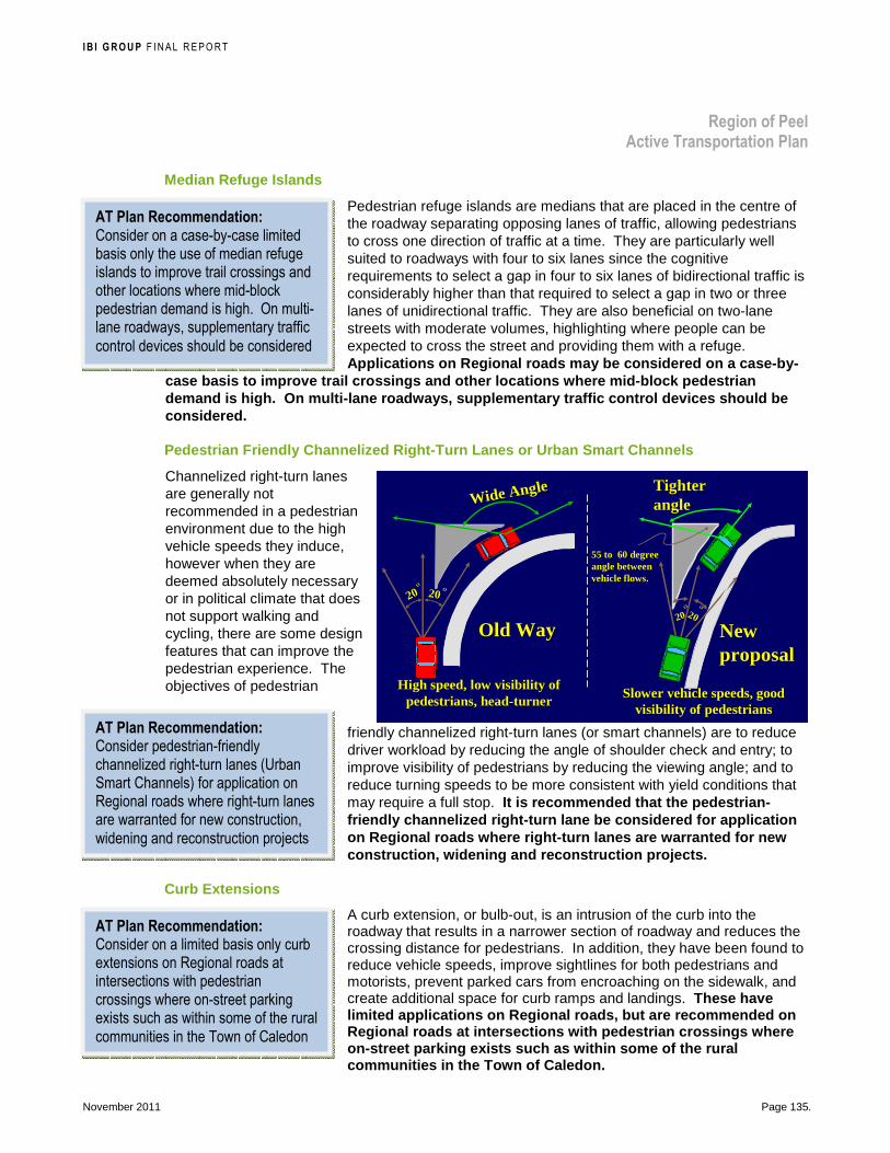
I B I G R O U P F INAL REPORT
Region of Peel Active Transportation Plan
November 2011 Page 135.
Median Refuge Islands
Pedestrian refuge islands are medians that are placed in the centre of the roadway separating opposing lanes of traffic, allowing pedestrians to cross one direction of traffic at a time. They are particularly well suited to roadways with four to six lanes since the cognitive requirements to select a gap in four to six lanes of bidirectional traffic is considerably higher than that required to select a gap in two or three lanes of unidirectional traffic. They are also beneficial on two-lane streets with moderate volumes, highlighting where people can be expected to cross the street and providing them with a refuge. Applications on Regional roads may be considered on a case-by-
case basis to improve trail crossings and other loc ations where mid-block pedestrian demand is high. On multi-lane roadways, supplement ary traffic control devices should be considered.
Pedestrian Friendly Channelized Right-Turn Lanes or Urban Smart Channels
Channelized right-turn lanes are generally not recommended in a pedestrian environment due to the high vehicle speeds they induce, however when they are deemed absolutely necessary or in political climate that does not support walking and cycling, there are some design features that can improve the pedestrian experience. The objectives of pedestrian
friendly channelized right-turn lanes (or smart channels) are to reduce driver workload by reducing the angle of shoulder check and entry; to improve visibility of pedestrians by reducing the viewing angle; and to reduce turning speeds to be more consistent with yield conditions that may require a full stop. It is recommended that the pedestrian-friendly channelized right-turn lane be considered for application on Regional roads where right-turn lanes are warran ted for new construction, widening and reconstruction projects.
Curb Extensions
A curb extension, or bulb-out, is an intrusion of the curb into the roadway that results in a narrower section of roadway and reduces the crossing distance for pedestrians. In addition, they have been found to reduce vehicle speeds, improve sightlines for both pedestrians and motorists, prevent parked cars from encroaching on the sidewalk, and create additional space for curb ramps and landings. These have limited applications on Regional roads, but are recommended on Regional roads at intersections with pedestrian cro ssings where on-street parking exists such as within some of the rural communities in the Town of Caledon.
High speed, low visibility of High speed, low visibility of pedestrians, headpedestrians, head--turnerturner
Wide Angle Wide Angle
Old WayOld Way
20202020 OOOO
55 to 60 degree 55 to 60 degree angle between angle between vehicle flows.vehicle flows.
New New proposalproposal
Slower vehicle speeds, good Slower vehicle speeds, good visibility of pedestriansvisibility of pedestrians
Tighter Tighter angleangle
2020OO
2020OO
AT Plan Recommendation: Consider on a case-by-case limited basis only the use of median refuge islands to improve trail crossings and other locations where mid-block pedestrian demand is high. On multi-lane roadways, supplementary traffic control devices should be considered
AT Plan Recommendation: Consider pedestrian-friendly channelized right-turn lanes (Urban Smart Channels) for application on Regional roads where right-turn lanes are warranted for new construction, widening and reconstruction projects
AT Plan Recommendation: Consider on a limited basis only curb extensions on Regional roads at intersections with pedestrian crossings where on-street parking exists such as within some of the rural communities in the Town of Caledon

I B I G R O U P F INAL REPORT
Region of Peel Active Transportation Plan
November 2011 Page 136.
Curb Return Radii
The design of the curb return at intersections depends on the types of vehicles expected to be using the intersection, the dimensions that make up the approaching and receiving lanes, and the curb radius itself. A compromise must often be made between a small curb radius, which is desirable to reduce the speed at which vehicles turn the corner, and a larger curb radius to prevent large vehicles from travelling across the curb and into the pedestrian zone when making a turn. Bike lanes and on-street parking can often mitigate the use of a small curb radius, providing a wider effective turning area. Where there is little
turning truck traffic, a minimum curb radius of 5 m is acceptable, such as at local streets intersecting with arterials when an occasional school bus, moving van, fire truck or oversized delivery truck may turn. For arterial road design, it is recommended that cu rb radii be based on the design vehicle (trucks or transit vehicles) making full use of the available roadway width in the direction of travel (not encroaching i nto on-coming traffic).
Curb Ramps
Curb ramps at street crossings are necessary to provide access from the street to the sidewalk for pedestrians who use mobility devices. However they can create barriers for people who are visually impaired and rely on the curb to identify the transition between the sidewalk and the street.
The five main types of curb ramps are as follows and are illustrated in Exhibit 31:
� Perpendicular: The ramp is perpendicular to the curb face and parallel to the direction of travel within the crosswalk (two ramps per corner). May not provide a straight path of travel on larger radius corners.
� Diagonal Typically one ramp is provided on the corner in a directional diagonal to the crosswalks (see photo). NOT recommended for it can be mistaken for a perpendicular ramp leading visual impaired into the intersection, and directs wheelchair / scooter users into the intersection (Ontario HTA requires pedestrians to cross within the crosswalk at and near intersections)
� Parallel: The ramp is parallel to the direction of pedestrian travel within the sidewalk, in which the sidewalk is ramped down to a level landing. Pedestrians need to negotiate two or more ramps, but the bottom landing is contained in the sidewalk, not the street. Can fit well within narrow sidewalk corridors.
� Combination Parallel and Perpendicular: The sidewalk is partially ramped to reduce the length of the perpendicular ramp and provide a level manoeuvring area at the top of the ramp. Provides a level area at the top and bottom of the ramp, but visually impaired must negotiate these sidewalk ramps even if not crossing.
� Depressed Corners: These eliminate the need to use curb ramps, however design details are required to prevent large vehicles from travelling onto the sidewalk when turning and to delineate / detect the boundary between the sidewalk and the street.
AT Plan Recommendation: For arterial road design, base curb radii on the design vehicle (trucks or transit vehicles) making full use of the available roadway width in the direction of travel (not encroaching into on-coming traffic)

I B I G R O U P F INAL REPORT
Region of Peel Active Transportation Plan
November 2011 Page 137.
Exhibit 31: Types of Curb Ramps
Perpendicular: Recommended except on larger radius corners where they may not provide a straight path of travel into / out of the crosswalk
Diagonal—NOT recommended

I B I G R O U P F INAL REPORT
Region of Peel Active Transportation Plan
November 2011 Page 138.
Parallel: Acceptable; fits well within narrow sidewalk corridors
Combination Parallel and Perpendicular: Acceptable
Depressed Corners: Acceptable if design allows detecting the boundary between the sidewalk and the street
I B I G R O U P F INAL REPORT
Region of Peel Active Transportation Plan
November 2011 Page 139.
Accessible design guidelines for curb ramps are as follows:
� Alignment: Align perpendicular to the curb face and parallel to the direction of travel within the crosswalk. This results in a straight path of travel from the top of the ramp to the roadway, through the crosswalk, to the curb ramp on the other side and to the top of that ramp
� Grade : A maximum grade of 8.3% is recommended.
� Grade changes: The change in grade between the ramp and the street must be 13% or less to prevent wheelchair users from being pitched forward or backward.
� Detectable warnings : Detectable warnings are standardised surface features built in or applied to walking surfaces to warn visually impaired persons of potential hazards such as at the bottom of curb ramps, depressed intersection corners, raised crosswalks and intersections, the edge of transit platforms, and railway tracks. The Initial Accessible Built Environment Standards recommends a surface of truncated domes aligned in a grid pattern that is colour contrasted with the adjacent walking surfaces.
� Transition points: Less than a 13 mm change in level between adjacent curb ramp surfaces
� Level landing: Level landings are required at the top and bottom of all curb ramps, and should be at least 1.5 m by 1.5 m with a cross slope not exceeding 2% in any direction.
� Drainage : Adequate drainage is required to prevent water and debris from accumulating at the bottom of the ramp.
Curb cuts or ramps should also be considered at all controlled and uncontrolled crossings of multi-use trails. City of Brampton is review their policy on curb cuts and ramps at uncontrolled trail crossings; they currently do not permit them. A barrier curb will not only be a hazard to trail users as they enter / exit the roadway, but will also increase the time that they are in the roadway exposed to traffic.
It is recommended that the Region of Peel adopt the most current standards / guidelines available for the design of accessible curb ramps with detectable warning devices for all contr olled and uncontrolled pedestrian crossings within their juri sdiction.
Accessible Pedestrian Signals (APS):
Formerly known as audible pedestrian signals, these provide visually impaired users with information on when they have the right-of-way to cross the street and in which direction they may cross an intersection. The Canadian National Institute for the Blind recommends that an APS be installed at signalised intersections that have pedestrian activated walk signals, a lead pedestrian phase, an advanced left turn phase, mid-block crossings, or at T-intersections. The Transportation Association of Canada published national guidelines, Guidelines for Understanding Use and Implementation of Accessible Pedestrian Signals, May 2008.
Including APS with new installations may efficiently advance APS installation programs, as they typically represent a marginal increase in the overall cost of newly signalized installations. However,
AT Plan Recommendation: Adopt the most current standards / guidelines available for the design of accessible curb ramps with detectable warning devices for all controlled and uncontrolled pedestrian road crossings within the Region of Peel’s jurisdiction.

I B I G R O U P F INAL REPORT
Region of Peel Active Transportation Plan
November 2011 Page 140.
it is recognized that demand for APS installations may exceed available funding to retrofit existing signalized intersections. The TAC guide provides an APS installation prioritization procedure that serves two functions: to assist in the identification of new candidate sites, and also to assist deploying agencies in the prioritization of incoming requests for installation. It is recommended that the Region of Peel develop a program for prioritizing and installing APS at tr affic signals on Regional roads in consultation with area municipali ties to ensure
consistency.
8.6.2 Intersection Treatments for Bikeways Supporting treatments can be used to improve comfort and safety for cyclists primarily though intersections, as illustrated in Exhibit 32. These can be used not only to improve access to bikeways on Regional roads but also for local bikeways intersecting Regional roads.
It is recommended that the Region of Peel set up a series of demonstration projects that address cyclists’ acces s at intersections to test the various treatments that a re not currently used by the Region of Peel. Locations and types of treatments to test should be determined in consultation with the area municipalities, and the Ministry of Transportation, Ontario, if required (for traffic control devices currently not in the Ontario Traffic Manuals or for locations near their facilities). In addition, consider ideas for improvements from stakeholders and members of the public, including suggestions submitted through the Walk and Roll Peel web site. Candidate sites are listed in Exhibit 33.
The City of Mississauga has implemented a pilot project installing ‘crossrides’ at several unsignalized intersections, with a signalized location to be implemented in 2011, under the guidance of the MTO. The City also has a bicycle loop detection pilot project at a signalized intersection with an inductive loop to detect cyclists installed in the bicycle lane on the side street.
Exhibit 32: Intersection Treatments that Improve Cy clists’ Access
Bicycle Detection at Traffic Signals
• Pavement markings—A symbol is put on the pavement to identify the most sensitive area of a detection loop where a bicycle will activate the traffic control signal
Bicycle Detection Pavement Marking, Vancouver �
AT Plan Recommendation: Develop a program for prioritizing and installing Accessible Pedestrian Signals at traffic signals on Regional roads in consultation with area municipalities to ensure consistency
AT Plan Recommendation: Set up a series of demonstration projects that address cyclists’ access at intersections to test the various treatments that are not currently used by the Region of Peel. Locations and types of treatments to test should be determined in consultation with the area municipalities, and the Ministry of Transportation, Ontario, if required. In addition, consider ideas for improvements from stakeholders and members of the public, including suggestions submitted through the Walk and Roll Peel web site.
Photo credit: Richard Drdul

I B I G R O U P F INAL REPORT
Region of Peel Active Transportation Plan
November 2011 Page 141.
• Push Button—A push button that activates the traffic control signal is mounted where is accessible to cyclists riding on the road
Traffic Control Signal Push Button for Cyclists, Vancouver �
Bike Box
• An area just in front of the stop bar for motorists at a traffic signal for cyclists to wait in and, when the signal turns green, proceed ahead of motorists; when the traffic signal is green, cyclists proceed through the intersection conventionally without using the bike box
• Reduces conflicts with right-turning motorists; accommodates high left-turning cyclist volumes
Bike Box, Victoria �
Two-stage Left Bike Box
• Designated area where cyclists may queue to facilitate a two-stage left-turn at a signalized intersection. If a cyclist on a major street wants to turn left, they travel through on the major street on the green phase and wait in this area that is located in front of the cross street approach until the signal turns green for the cross street traffic. Then the cyclist proceeds on the cross street green phase, completing the “left-turn” from the major street to the cross street. Laurier Avenue, Ottawa �
Bicycle Only Traffic Signals
• Traffic control signals that allow cyclists to proceed through an intersection while motorists are stopped by a conventional red light on a separate traffic signal head
Bicycle Traffic Control Signals, Montreal �
Photo credit: John Luton
Photo credit: Mooniker

I B I G R O U P F INAL REPORT
Region of Peel Active Transportation Plan
November 2011 Page 142.
Raised Trail Priority Crossings
• Where a trail crosses a roadway, a speed hump is installed to slow traffic and increase visibility of the crossing
• Traffic control can be installed to give priority to the trail traffic over the street traffic
Galloping Goose Trail Raised Priority Crossing, Saanich �
Cyclists Left-turn Lane
• Left-turn pocket provided in median on major roadway so cyclists can access side street or trail
Cyclist Left-turn Lane access for Galloping Goose Trail, Saanich �
“Crossbike” or “Crossride”
• Crossing area for cyclists adjacent a crosswalk. The Ontario Highway Traffic Act requires cyclists to dismount in pedestrian crosswalks; the “crossbike” provides an defined crossing area but without the requirement to dismount
• Mississauga has implemented pilot crossrides at several unsignalized intersections and will implement a pilot at a signalized intersection in 2011 under the guidance of the MTO.
Crossride, Mississauga �
Sharrows in Conflict Areas
• Intersections and bike lanes adjacent right-turn lanes or ramp merges / diverges can be marked with “sharrows” (double chevron and bicycle symbol) or other markings where weaving with motorists occur. The symbol brings attention to both users of the conflict area
Cycle track through intersection marked with “sharrows”, Montreal �
Photo credit: John Luton
Photo credit: John Luton
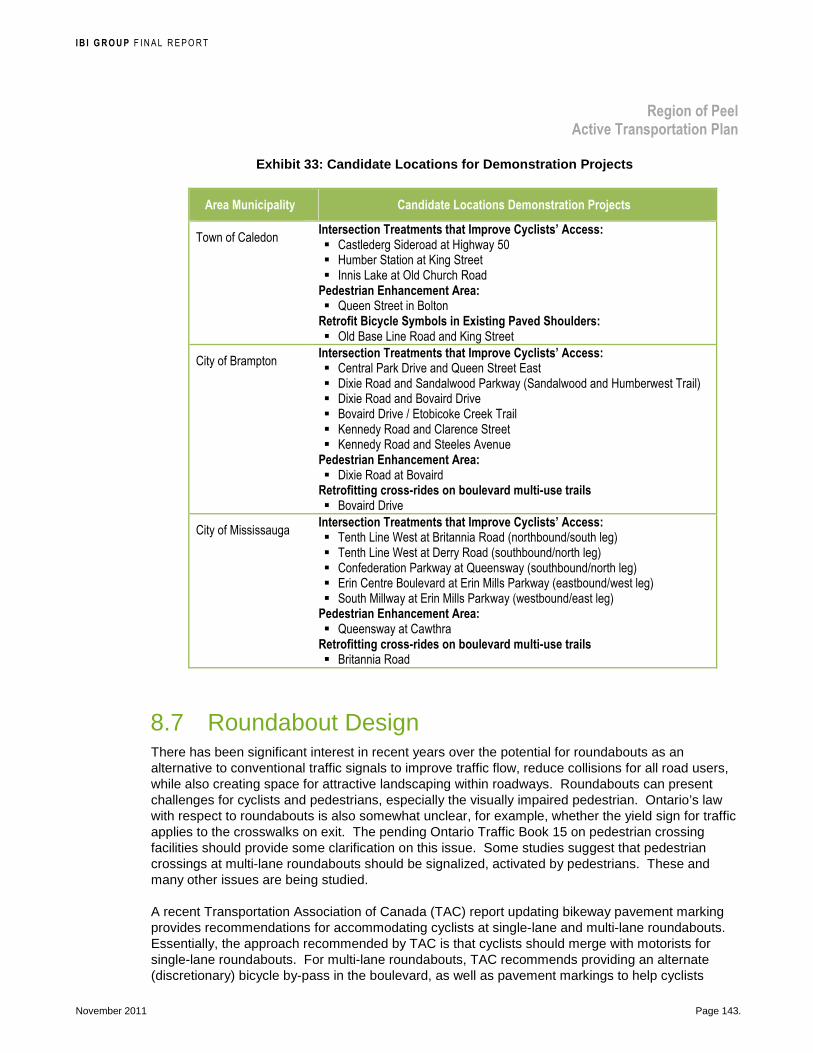
I B I G R O U P F INAL REPORT
Region of Peel Active Transportation Plan
November 2011 Page 143.
Exhibit 33: Candidate Locations for Demonstration P rojects
Area Municipality Candidate Locations Demonstration Projects
Town of Caledon Intersection Treatments that Improve Cyclists’ Access: � Castlederg Sideroad at Highway 50 � Humber Station at King Street � Innis Lake at Old Church Road
Pedestrian Enhancement Area: � Queen Street in Bolton
Retrofit Bicycle Symbols in Existing Paved Shoulders: � Old Base Line Road and King Street
City of Brampton Intersection Treatments that Improve Cyclists’ Access: � Central Park Drive and Queen Street East � Dixie Road and Sandalwood Parkway (Sandalwood and Humberwest Trail) � Dixie Road and Bovaird Drive � Bovaird Drive / Etobicoke Creek Trail � Kennedy Road and Clarence Street � Kennedy Road and Steeles Avenue
Pedestrian Enhancement Area: � Dixie Road at Bovaird
Retrofitting cross-rides on boulevard multi-use trails � Bovaird Drive
City of Mississauga Intersection Treatments that Improve Cyclists’ Access: � Tenth Line West at Britannia Road (northbound/south leg) � Tenth Line West at Derry Road (southbound/north leg) � Confederation Parkway at Queensway (southbound/north leg) � Erin Centre Boulevard at Erin Mills Parkway (eastbound/west leg) � South Millway at Erin Mills Parkway (westbound/east leg)
Pedestrian Enhancement Area: � Queensway at Cawthra
Retrofitting cross-rides on boulevard multi-use trails � Britannia Road
8.7 Roundabout Design There has been significant interest in recent years over the potential for roundabouts as an alternative to conventional traffic signals to improve traffic flow, reduce collisions for all road users, while also creating space for attractive landscaping within roadways. Roundabouts can present challenges for cyclists and pedestrians, especially the visually impaired pedestrian. Ontario’s law with respect to roundabouts is also somewhat unclear, for example, whether the yield sign for traffic applies to the crosswalks on exit. The pending Ontario Traffic Book 15 on pedestrian crossing facilities should provide some clarification on this issue. Some studies suggest that pedestrian crossings at multi-lane roundabouts should be signalized, activated by pedestrians. These and many other issues are being studied.
A recent Transportation Association of Canada (TAC) report updating bikeway pavement marking provides recommendations for accommodating cyclists at single-lane and multi-lane roundabouts. Essentially, the approach recommended by TAC is that cyclists should merge with motorists for single-lane roundabouts. For multi-lane roundabouts, TAC recommends providing an alternate (discretionary) bicycle by-pass in the boulevard, as well as pavement markings to help cyclists
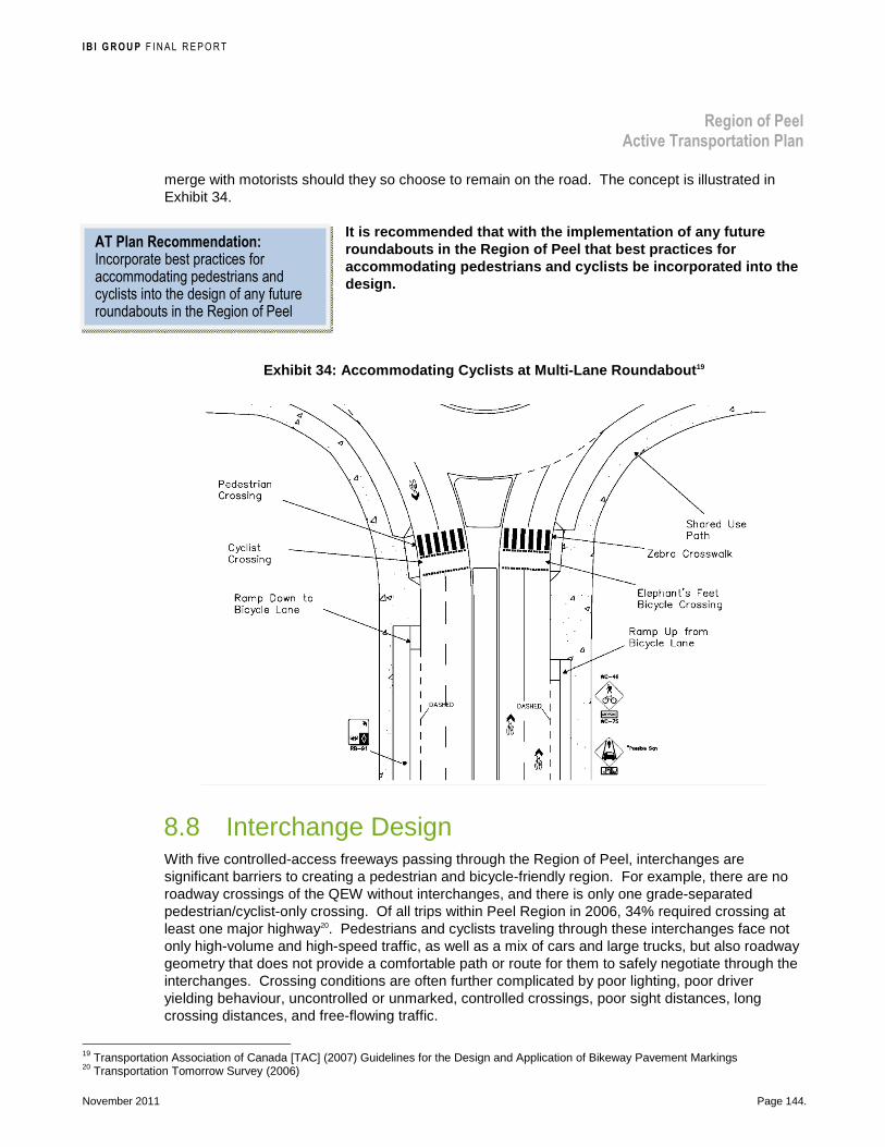
I B I G R O U P F INAL REPORT
Region of Peel Active Transportation Plan
November 2011 Page 144.
merge with motorists should they so choose to remain on the road. The concept is illustrated in Exhibit 34.
It is recommended that with the implementation of a ny future roundabouts in the Region of Peel that best practic es for accommodating pedestrians and cyclists be incorpora ted into the design.
Exhibit 34: Accommodating Cyclists at Multi-Lane Ro undabout 19
8.8 Interchange Design With five controlled-access freeways passing through the Region of Peel, interchanges are significant barriers to creating a pedestrian and bicycle-friendly region. For example, there are no roadway crossings of the QEW without interchanges, and there is only one grade-separated pedestrian/cyclist-only crossing. Of all trips within Peel Region in 2006, 34% required crossing at least one major highway20. Pedestrians and cyclists traveling through these interchanges face not only high-volume and high-speed traffic, as well as a mix of cars and large trucks, but also roadway geometry that does not provide a comfortable path or route for them to safely negotiate through the interchanges. Crossing conditions are often further complicated by poor lighting, poor driver yielding behaviour, uncontrolled or unmarked, controlled crossings, poor sight distances, long crossing distances, and free-flowing traffic.
19 Transportation Association of Canada [TAC] (2007) Guidelines for the Design and Application of Bikeway Pavement Markings 20 Transportation Tomorrow Survey (2006)
AT Plan Recommendation: Incorporate best practices for accommodating pedestrians and cyclists into the design of any future roundabouts in the Region of Peel

I B I G R O U P F INAL REPORT
Region of Peel Active Transportation Plan
November 2011 Page 145.
At a very basic level, pedestrians and cyclists approaching freeway interchanges typically are confronted with either free-flowing traffic to/from ramps, signal or stop-controlled intersections, or a combination of both. Cyclist and pedestrian comfort and safety is primarily influenced by the speed, volume, and mix of traffic, all of which are affected by roadway geometry, adjacent land-uses, and traffic operations.
The specific geometry through the interchange may include a structure, on-ramps, off-ramps, overpasses or underpasses (structures) of the freeway mainline, and crossing roadways which may or may not have sidewalks, bikeways, or paved shoulders. Both on- and off-ramps may also include stop-controlled or signalized intersections, which may involve channelization. The particular combination of these elements and how they affect the cyclist or pedestrian experience, along with the available roadway and structure width, influences the route through the interchange and informs potential design improvements. Where feasible, cyclists and pedestrians will be accommodated at interchanges through ramp improvements (e.g., pavement markings, signage) and lane width re-striping adjacent and across existing structures. Individual interchanges will need to be assessed to
determine where lane width modifications to accommodate continuous active transportation routes are feasible, or where structure widening or construction would be required.
The Ministry of Transportation, Ontario is currently studying integrating vulnerable users at interchanges within the Greater Golden Horseshoe Area and Niagara Region. It is recommended that the Region of Peel and the area municipalities encourage and work with the Ministry of Transportation, Ontario to develop a pr ogram to retrofit interchanges identified in the recommended active transportation network with improvements to better accommodate pedestrians and cyclists while maintaining a safe e nvironment for all users.
Accommodating Pedestrians
Aside from general recommendations on tightening the angle of channelized right-turn lanes (see Section 8.6.1, Accessible Street Crossings for Pedestrians, page 133), very little has actually been written on the subject of accommodating pedestrians at interchanges. With progressively more urbanization, freeways are increasingly surrounded by important destinations within walking distance of one another and the issue of accommodating pedestrians in such environments is ever more pressing.
The recommendations in AASHTO’s Guide for the Planning, Design, and Operation of Pedestrian Facilities include providing direct connections where possible, crosswalks, adequate lighting and sight distances, warning signage, pedestrian-actuated signals or stop or yield signs at crossings, slower speed limits at urban interchanges, channelization islands as refuges, and right-angle intersections for ramps.
Furthermore, it should be emphasized that pedestrians must have access to sidewalks alongside the roadways and on over- or underpasses. It is recommended that for overpasses, the handrails be higher than usual to accommodate a variety of users. As well, pedestrian crossings should be conveniently located to support direct pedestrian routes. As much as possible, such crossings should be located close to the areas with the slowest traffic speeds. Where traffic signals are present, high-visibility crosswalk markings should be used. Similar general recommendations were pointed out by Rutgers in Bicycle and Pedestrian Safety Needs at Grade-Separated Interchanges (2008), along with recommendations for new construction or interchange re-configuration.
AT Plan Recommendation: Region of Peel and the area municipalities to encourage and work with the Ministry of Transportation, Ontario to develop a program to retrofit interchanges identified in the recommended active transportation network with improvements to better accommodate pedestrians and cyclists while maintaining a safe environment for all users

I B I G R O U P F INAL REPORT
Region of Peel Active Transportation Plan
November 2011 Page 146.
Accommodating Cyclists
Various design tools are noted in North American bikeway design guidelines and reports that could be applied to interchanges. Some design, pavement marking and signage recommendations from various Transportation Association of Canada reports are illustrated in Exhibit 35. The references should be reviewed for further details on the devices (pavement markings and signs), design criteria, guidance and applications. The recommendations include:
Exhibit 35: Transportation Association of Canada Gu idance for Accommodating Cyclists Through Interchanges
Jug Handle at Merging Ramp (>70 km/h)
Transportation Association of Canada, Geometric Design Guide for Canadian Roads (1999): Bikeways Crossing Freeway Exit Type Ramps �
Jug Handle at Diverging Ramp (>70 km/h)
Transportation Association of Canada, Geometric Design Guide for Canadian Roads (1999): Bikeways Crossing Freeway Entrance Type Ramps �

I B I G R O U P F INAL REPORT
Region of Peel Active Transportation Plan
November 2011 Page 147.
Transportation Association of Canada, Guidelines for the Design and Application of Bikeway Pavement Markings (December 2007): Cyclist Crossing (High Speed >70 km/h) Off-ramp with Jug Handle (This application assumes the bike lane is on the freeway, but could be applied where ramps diverge from high-speed arterial roadways with bike lanes) �

I B I G R O U P F INAL REPORT
Region of Peel Active Transportation Plan
November 2011 Page 148.
Crossing Area Unmarked at Diverging Ramp (>70 km/h)
Transportation Association of Canada, Guidelines for the Design and Application of Bikeway Pavement Markings (December 2007): Cyclist Crossing at High-Speed (>70 km/h) Interchange Off-Ramp Along the Ramp—No Crossing Area Cyclist Markings (This application assumes the bike lane is on the freeway, but could be applied where ramps diverge from high-speed arterial roadways with bike lanes) �

I B I G R O U P F INAL REPORT
Region of Peel Active Transportation Plan
November 2011 Page 149.
Bike Lane through Conflict Zones: Weave, Merge or Diverge Areas
� Transportation Association of Canada, Coloured Bicycle Lanes Simulator Testing (May 26, 2008): Conflict zones are defined as areas where cyclists have the right of way but where this may not be understood by motorists or even cyclists. For example, where a right-turn lane is added or a curb lane becomes a right-turn only lane and the bike lane is intended to carry straight through. Conflicts arise between cyclists and right-turning motorists in these cases since their paths cross. Another example is at merging and diverging ramps in interchanges.
These markings must not, however, be used to demarcate conflict zones across high-speed roadway ramps (roadways >70 km/h), as the high speed differential between cyclists and motorists introduce a significant conflict potential and motorists do not typically expect to yield to cyclists in these locations.
In areas where conflict zones are of particular concern, the white “sharrow” marking (bicycle stencil with chevron arrows may be added as a potential optional treatment.
Note that the addition of the stencil does not replace any of the conventional bikeway marking requirements and may therefore require dashed guiding lines on either side. The “sharrow” marking should extend through the conflict zone whether at an intersection or elsewhere. Consideration of what would be a conflict zone should be done by a qualified professional using industry standard safety or conflict analysis techniques.
8.9 Pedestrian Enhancements The quality of the pedestrian experience goes beyond the basic provision of sidewalks. Enhancements focus on streetscape elements, and may include a combination of upgrading accessibility (e.g. curb ramp retrofits with detectable warnings); addressing street crossing improvements; widening sidewalks if required; gateways; street furniture such as benches or seating walls, signage, water fountains, and trash receptacles; lighting, shade or wind breaks, plantings, public art, etc. These enhancements can also be centred on transit stops and stations. Some elements, such as landscaping, may be located on adjacent private property. Together these elements improve the quality of the public realm. It is noted that currently the Region of Peel plants and maintains grass / trees / shrubs when it is part of an agreement with the area municipalities. Gateway treatments are outside of Region’s right-of-way and street furniture, lighting, trash receptacles are area municipal infrastructure.
It is recommended that the Region of Peel identify a demonstration project in each area municipality to introduce pedestrian enhancements a long Regional roads in priority areas identified on the Recommended Pedestrian Network. A lternative funding strategies, as

I B I G R O U P F INAL REPORT
Region of Peel Active Transportation Plan
November 2011 Page 150.
presented in Part 2, can be explored. Enhancements should also be explored with new and reconstruction projects to take advantage of cost efficiencies.
An example of pedestrian enhancements is on Bovaird Drive in front of the Brampton Civic Hospitals. In addition to the wider sidewalk and a transit shelter, there is
textured pavement outside the pedestrian travel zone, a shade screen, street trees, a bench, and a garbage receptacle.
8.10 Cycling and Trail Network Signage Strategies The Transportation Association of Canada’s (TAC) Bikeway Traffic Control Guidelines for Canada (December 1998) indicates that bikeway guide and informational signs convey information to cyclists for route selection, for locating off-road facilities, or for identifying geographical features or points of interests. These Guidelines indicate that on shared rights-of-way, separate signing for cyclists is not necessary; however, guide and informational signs are intended to help cyclists find their way in unfamiliar areas and provide insight into the coherence of a network of bikeway routes.
Street name signposting, and guide and informational signs for motorized traffic are not ideal from the cyclist’s and trail user’s viewpoint, in terms of positioning and information:
� Some bikeways are designed to take advantage of low traffic speeds or volumes, or scenic routes and as such may not remain on any given street. The bike route will take turns and short-cuts not intended for motorists but of great advantage to cyclists. Separate signing of these routes is required for way-finding.
� Cyclists generally travel shorter distances than motorists and are more concerned with direct connections to destinations within those smaller areas. They may require information on the exact route to the frontage of the property or building that is bicycle-accessible. For example, circulating by bike around a shopping or transit centre to find bike parking or bicycle lockers could be very frustrating.
� Time and distance along bike routes and trails to destinations can indicate to the traveling public that the trip is quite manageable by bicycle.
� Advance signing for a cyclist on a roadway or trail approaching a roadway with a bike lane, or other type of bikeway on it is needed. The cyclist will not be aware that the bikeway exists until they pass through the intersection or they may not detect the bikeway at all. If they do detect it at the intersection, they may not be in a position that allows them to turn directly onto the bikeway, and then will have to expend additional personal energy to go out of their way to turn around.
� A coherent and consistent system of way-finding signs for cyclists is lacking in Canada. Some of the shortcomings of bicycle route signage programs include:
AT Plan Recommendation: Identify a demonstration project in each area municipality to introduce pedestrian enhancements along Regional roads in priority areas identified on the Recommended Pedestrian Network. Enhancements should also be explored with new and reconstruction projects to take advantage of cost efficiencies.

I B I G R O U P F INAL REPORT
Region of Peel Active Transportation Plan
November 2011 Page 151.
– Signs are inconsistently implemented across a network such that some routes are well marked and others are not.
– Useful information from a cyclist’s perspective, such as destinations, directions, distances, amenities, is lacking or inconsistent across a network.
– Signs are not maintained on an annual or as-needed basis with signs disappearing over time.
– Initial implementation of bicycle route network signage is not continued as the network expands over time such that older sections are signed and newer sections are not. The reverse can also happen if older signs are not maintained but newer signs are installed as the network expands.
– Sign placement is poor so that it is not easily visible to cyclists.
– Signage types are lacking, i.e., route confirmation signs at regular intervals, change in route direction signs, intersection signs of two or more bicycle routes, advance or access signs from major roadways or trails to bicycle routes.
Bicycle route and trail signage is important for integrating the on-road system with the multi-use pathway system, and area municipal bikeways with Regional bikeways to form an overall co-ordinated network. The signage should be easy to integrate into bicycle route and trail maps, and address the features such as route confirmation, route intersections, connectivity, advance route signing, destinations, directions, distances (or time), and amenities. Such a signage plan would go beyond the basic guide and information signs recommended by TAC. Consistency with Provincial sign design principles is also recommended.
Examples of bicycle route signage from North America and Europe are provided in Exhibit 36. These illustrate the basic bike route guide signing to more complex signing that provides useful information on destinations, distances and amenities.
Currently area municipalities in Peel fund, design, install and maintain signs on multi-use trails. The Region of Peel can install signs on behalf of the area municipalities during road widening projects. As part of the walk and roll peel initiative, the Region of Peel will fund and place the Walk and Roll Peel logo on trailhead signs.
Traffic signs along rural Regional roads are funded, installed and maintained by the Region of Peel. If the paved shoulder is intended to be used by others such as agricultural vehicles and horses with buggies, then the lane should NOT be reserved for bicycles only. The bike lane regulatory sign and
the diamond symbol pavement marking would be omitted. However, bicycle route signs (as part of an overall signage strategy) and bicycle symbol pavement marking are recommended to bring attention to and promote the use of the shoulder by cyclists.
It is recommended that the Region of Peel establish a working group involving the area municipalities to plan and implement a co-ordinated active transportation network signage strategy based on communicating the route and direction / di stance to destinations and amenities. The strategy should ta ke into account established trail signage strategies in Bra mpton, Mississauga and along the Caledon Trailway, and con sider incorporating identifiers such as the Walk and Roll Peel logo.
AT Plan Recommendation: Region of Peel to establish a working group involving the area municipalities to plan and implement a co-ordinated active transportation network signage strategy based on communicating the route and direction / distance to destinations and amenities. The strategy should take into account established trail signage strategies in Brampton, Mississauga and along the Caledon Trailway, and consider incorporating identifiers such as the Walk + Roll Peel logo

I B I G R O U P F INAL REPORT
Region of Peel Active Transportation Plan
November 2011 Page 152.
Exhibit 36: Examples of Bikeway Signage
Basic bicycle route sign
Not very useful without additional information about the bicycle route network. Note that TAC’s recommended Bicycle Route Marker Sign includes the word “ROUTE” below the bicycle symbol. Photo by Richard Drdul
Bicycle route marker sign with destinations
Plus direction at decision points in the bicycle route network. Photo by Richard Drdul
Additional information provided includes direction, distance and average time by bicycle at decision points in the bicycle route network. Photo by Richard Drdul

I B I G R O U P F INAL REPORT
Region of Peel Active Transportation Plan
November 2011 Page 153.
Bicycle route marker sign with route number
Additional information provided includes cardinal direction.
Street name blade with bicycle logo
Identifies a street as a bikeway to cyclists and motorists. Photo by Richard Drdul
Bicycle boulevard signage
Identifies the street as a priority street for cyclists with a route name and includes destinations, distances and directions. Photo from City of Berkley, CA

I B I G R O U P F INAL REPORT
Region of Peel Active Transportation Plan
November 2011 Page 154.
European bicycle route signage
Includes region name, node number, destinations, directions, distances, amenities, and map.
City of Brampton sample signage
Trail Identifier Sign

I B I G R O U P F INAL REPORT
Region of Peel Active Transportation Plan
November 2011 Page 155.
City of Mississauga sample signage
8.11 Site Design for Active Transportation Recent decades of urban development in North America have led to a general reliance on personal vehicles for commuting, recreational and other personal travel, which has had arguably improved mobility and accessibility– but not without negative impacts to natural, economic and social environments. Many jurisdictions and municipalities are actively responding to this undesirable situation through land-use planning, transit system improvements, pedestrian safety initiatives, bicycle system plans, transportation demand management (TDM) programs and smart growth initiatives. However, these strategies are generally aimed at transportation infrastructure, high-level land-use or funding issues. They tend to offer little guidance to development planning and review processes such as site design.
Recognizing this gap in consolidated information and guidelines relating to site design practices that promote sustainable transportation, the Institute of Transportation Engineers (ITE) created Promoting Sustainable Transportation Through Site Design: An ITE Recommended Practice (2010). This document was developed to provide planning authorities and the land development industry with site design practices and planning processes that help promote sustainable transportation.

I B I G R O U P F INAL REPORT
Region of Peel Active Transportation Plan
November 2011 Page 156.
Drawing on the ITE guideline, this section provides suggested practices that would be applicable in the Region of Peel for improving site design for active transportation. It is recommended that the Region of Peel adopt guidelines in their review of site development applications as they apply to their jur isdiction and encourage the area municipalities to do the same.
Site Organization
Site organization is one of the first stages of site design and has a significant impact on elements that affect sustainable transportation, as illustrated in the “typical” versus “modal” example in Exhibit 37. Typical decisions that are made at this stage include building location and placement, parking lot size and configuration (e.g. at grade, above, grade or below grade) and entrance locations.
Some of the design considerations made at this initial stage of site design that would help to create better environments for active transportation include:
� Ensuring Building parallel to the street and at a consistent set back provides a well defined public edge
� Animating the public sidewalk with street front uses
� Locating ancillary uses (e.g. daycares, convenience stores, etc.) closest to potential users
� Locating the highest density uses close to intersections.
� Providing building entrances close to street and transit stops in order to animate the street and minimize walking distances
� Constructing mixed-use development to allow people to live near work.
� Minimizing parking supply to provide opportunities for other uses such as parks while discouraging auto use
� Locating surface parking to the rear of site, away from pedestrian activities
AT Plan Recommendation: Adopt site design guidelines that promote active transportation in the Region of Peel’s review of site development applications as they apply to their jurisdiction and encourage the area municipalities to do the same

I B I G R O U P F INAL REPORT
Region of Peel Active Transportation Plan
November 2011 Page 157.
Exhibit 37: Typical versus Model Site Layout for Pr omoting Sustainable Transportation
Source: TRI MET, Planning and Designing for Transit Handbook
Site Layout
Site layout determines how pedestrians, cyclists, transit users and motor vehicle drivers and passengers will arrive at the site and travel through the site. As a result, site layout has a significant impact on whether users of different modes can safely and comfortably co-exist. Major decisions at this stage of the design process include determining the internal road configuration (where internal roads or driveways are required), parking layout and configuration, and the location of transit facilities, bicycle facilities and passenger pick-up and drop-off areas in relation to buildings and the internal and/or adjacent street network.
� Pedestrian crossings, including mid-block crossings are well defined
� Pedestrian connections are possible through the site
� Number of driveways and mid-block access/egress is minimized
� Transit stops are provided close to main generators and key pedestrian routes
� Loading areas are underground in order to minimize visual impact and maximize safety
� Where loading is above ground, access does not interfere with pedestrians and cyclists
� Short-term bike parking is located in visible areas and protected from elements
� On-street parking is factored into supply, provides a buffer for pedestrians
� Parking lots are developed in modules and pedestrian routes are protected

I B I G R O U P F INAL REPORT
Region of Peel Active Transportation Plan
November 2011 Page 158.
� Preferred carpool/vanpool parking is provided closest to destinations
� Avoid drive-throughs, which tend to sever pedestrian movements though a site and add to vehicle emissions due to idling
Contrasting Examples showing the impacts of site layout are provided in Exhibit 38.
Exhibit 38: Contrasting Examples of Site Layout
Poor Considerations for Active Transportation Good Considerations for Active
Transportation
Pedestrian-vehicle interaction
Pedestrian routes
Cycling Routes
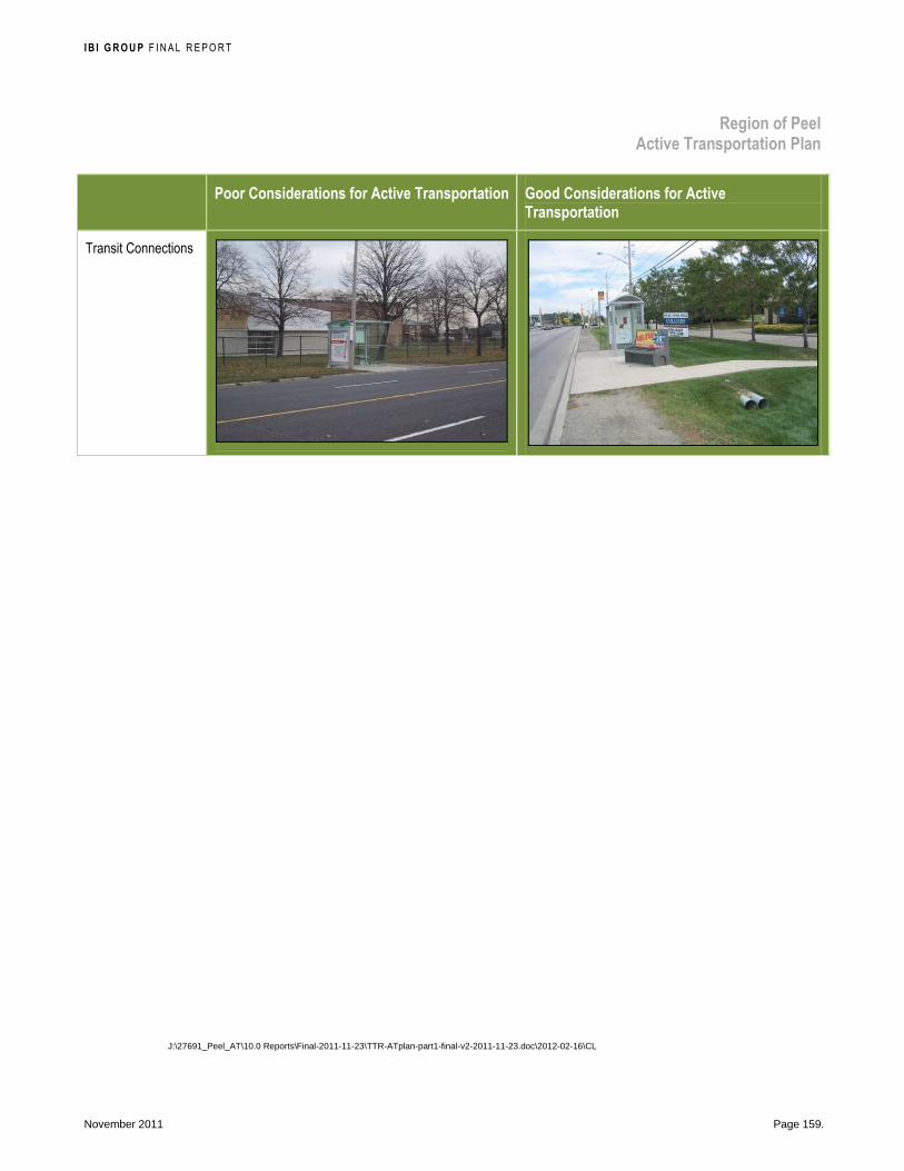
I B I G R O U P F INAL REPORT
Region of Peel Active Transportation Plan
November 2011 Page 159.
Poor Considerations for Active Transportation Good Considerations for Active
Transportation
Transit Connections
J:\27691_Peel_AT\10.0 Reports\Final-2011-11-23\TTR-ATplan-part1-final-v2-2011-11-23.doc\2012-02-16\CL