regiOn 3: Blue ridge Rappahannock-Rapidan … by...2035 Virginia Surface TranSporTaTion plan 23 In...
21
2035 VIRGINIA SURFACE TRANSPORTATION PLAN 23 In the heart of Virginia, where the Blue Ridge Mountains meet gently rolling hills, lies a region rich in natural beauty, American history, farmlands, and quaint cities and towns. The attractiveness of the region combined with its close proximity to major employment centers, has created a demand for a more suburban style of living. Over the past 10 years, the northern portion of the Blue Ridge Region has experienced increasing growth pressures from the Washington, DC, metropolitan area. This growth pressure is expected to continue, requiring proactive transportation decision-making and strategies to manage congestion and ensure the availability of multimodal transportation options. The size of this region presents a variety of public transportation challenges in the future. The northern portion of this region will need to focus on providing better transit service for commuting and daily trips to increase the mode share for transit, and promote strategies to reduce congestion, especially during peak hours. In the southern portion, as the population REGION 3: BLUE RIDGE PDCs in the Blue Ridge Region Rappahannock-Rapidan Regional Commission Thomas Jefferson Virginia’s Region 2000 Local Government Council West Piedmont Southside Virginia’s Heartland Commonwealth Regional Commission • • • • • • Strategies for the Blue Ridge Region Provide Safety Improvements Enhance Demand Response Transit ITS Expand Freight Rail Service Increase and Improve Bicycle and Pedestrian Facilities • • • • • ages, it is likely that a growing number of the population may not have access to a personal vehicle, leading to a need for more demand response and human services transport. Transportation in this region is largely characterized by US 29 and 15, providing connections between the Washington DC metropolitan area, central Virginia and North Carolina. The lack of a north-south interstate highway strains the existing highways in this region. To continue to provide mobility for central Virginia residents and for freight commodities, improvements are recommended for highways including US 29, US 15 and I-64. In addition, investments in demand-response and fixed-route transit service will ensure accessible transportation is available for those who do not rely on a personal vehicle. Passenger and freight rail improvements will also help to increase the capacity of central Virginia’s transportation system.
Transcript of regiOn 3: Blue ridge Rappahannock-Rapidan … by...2035 Virginia Surface TranSporTaTion plan 23 In...

2035 Virginia Surface TranSporTaTion plan �23
In the heart of Virginia, where the Blue Ridge Mountains meet gently rolling hills, lies a region rich in natural beauty, American history, farmlands, and quaint cities and towns. The attractiveness of the region combined with its close proximity to major employment centers, has created a demand for a more suburban style of living.
Over the past 10 years, the northern portion of the Blue Ridge Region has experienced increasing growth pressures from the Washington, DC, metropolitan area. This growth pressure is expected to continue, requiring proactive transportation decision-making and strategies to manage congestion and ensure the availability of multimodal transportation options.
The size of this region presents a variety of public transportation challenges in the future. The northern portion of this region will need to focus on providing better transit service for commuting and daily trips to increase the mode share for transit, and promote strategies to reduce congestion, especially during peak hours. In the southern portion, as the population
regiOn 3: Blue ridge
PDCs in the Blue Ridge RegionRappahannock-Rapidan Regional CommissionThomas JeffersonVirginia’s Region 2000 Local Government CouncilWest PiedmontSouthsideVirginia’s Heartland Commonwealth Regional Commission
••••••
Strategies for the Blue Ridge RegionProvide Safety ImprovementsEnhance Demand Response TransitITSExpand Freight Rail ServiceIncrease and Improve Bicycle and Pedestrian Facilities
•••••
ages, it is likely that a growing number of the population may not have access to a personal vehicle, leading to a need for more demand response and human services transport.
Transportation in this region is largely characterized by US 29 and 15, providing connections between the Washington DC metropolitan area, central Virginia and North Carolina. The lack of a north-south interstate highway strains the existing highways in this region. To continue to provide mobility for central Virginia residents and for freight commodities, improvements are recommended for highways including US 29, US 15 and I-64. In addition, investments in demand-response and fixed-route transit service will ensure accessible transportation is available for those who do not rely on a personal vehicle. Passenger and freight rail improvements will also help to increase the capacity of central Virginia’s transportation system.

chapTer 6�2�
transpOrtatiOn faCilities and serViCesThe transportation characteristics of this region are mostly defined by US 29, which is a highway running north-to-south in the eastern United States for over 1,000 miles. In Virginia, US 29 serves as the major north-south corridor through the central part of the state, as it lies west of I-95 and east of I-81. It provides the main connection between the Washington, DC metropolitan area and the cities of Charlottesville, Lynchburg and Danville, and provides local access to many of these areas as well as smaller communities. It is a freight alternative to the heavy freight corridor of I-81 to the west, and is one of two major corridors (along with US 460) serving the Lynchburg area. US 29 runs concurrently with other roadways throughout its course in Virginia, including US 15 for a long stretch near Warrenton, US 250 near Charlottesville, and US 460 near Lynchburg. Route 29 is also defined as a National Scenic Highway. I-64 travels through this region and serves as a major route for freight and tourism as the only east-west interstate that traverses the Commonwealth of Virginia. Other major east-west routes include US 460 and US 58.
multimOdal faCilities and serViCes: Blue ridge regiOn
Fixed Route (FR) & Demand Response (DR)
Transit (9): Blackstone Area Bus (FR)
Charlottesville Area Transit (FR)
Danville Transit System (FR)
Farmville Area Bus (FR)
Greater Lynchburg Transit (FR/DR)
Greene County Transit (DR)
Halifax Area Transit Service (DR)
JAUNT (FR/DR)
Virginia Regional Transit (FR/DR)
Transportation Demand Management (2):Rappahannock-Rapidan Commuter
Services
RIDESHARE
Short Line (3):Buckingham Branch Railroad
Chesapeake Western Railroad
Shenandoah Valley Railroad
Human Service Transportation (9):Central VA Area Agency on Aging
Crossroads Community Services
Danville City’s Parks, Recreation and
Tourism
Danville-Pittsylvania Community Services
Lake Area Bus
•
•
•
•
•
•
•
•
•
•
•
•
•
•
•
•
•
•
•
Southside Community Services Board
STEPS
Stonewall Therapeutic Recreation Center
The Arc Of Central Virginia
Freight Rail (1):Norfolk Southern Crescent Corridor
Passenger Rail (1):Amtrak Crescent Route
HighwayPark and Ride
Airports (13):Brookneal
Charlottesville-Albemarle
Culpeper County
Danville Regional
Falwell
Farmville Regional
Gordonsville Municipal
Lake Anna
Louisa County
Lynchburg RegionalOrange County
Warrenton-Fauquier
William M Tuck
•
•
•
•
•
•
•
•
•
•
•
•
•
•
•
•
•
•
•
•

2035 Virginia Surface TranSporTaTion plan �25
Nine transit services operate in cities, towns and counties throughout the Blue Ridge Region providing both demand response and fixed route service. JAUNT, a regional transportation system, provides express bus transit service to the City of Charlottesville, Albemarle, Fluvanna, Nelson and Buckingham Counties. Greyhound offers bus service within this region, with stations located in Danville, Lynchburg, Charlottesville, and Northern Virginia. Amtrak offers daily service with stops in Lynchburg, Charlottesville, Culpeper, Manassas, Burke Center (VRE riders only), Alexandria and Washington DC, with continuing service to Boston, MA. Park and Ride lots are also available in Fauquier County and Culpeper County along US 29, and there are numerous Park and Ride facilities located in and around the City of Charlottesville along US 29, including at least three lots south of the city in Nelson County.
The Blue Ridge Region has two Transportation Demand Management agencies that help to promote strategies like carpooling, vanpooling, work-from home initiatives and flexible work hours in the Rappahannock-Rapidan and Charlottesville areas (Rappahannock-Rapidan Commuter Services and RIDESHARE). To fill critical mobility gaps for Virginians who do not have access to a personal automobile and live outside of public transit service areas, eight human service agencies exist in the Valley and Ridge region, one in the Culpeper district, and seven in the Lynchburg district.
Norfolk Southern freight rail lines run along virtually the entire US 29 corridor in Virginia, offering a freight option to points south along, as well as north of, Washington DC and to the northeast. The eastern line of Norfolk’s Crescent Route runs along Route 29, and connection along the I-66 corridor Norfolk Southern rail lines can be made to the Virginia Inland Port and the western line of Norfolk Southern’s Crescent Corridor, which runs along the I-81 corridor. In Charlottesville, these Norfolk Southern lines junction with CSX’s Coal Corridor, which provides a connection between the Port of Virginia and the Appalachian coalfields to the west.
The Lynchburg Regional Airport and Charlottesville-Albemarle Airport provide commercial service through a variety of major airlines. These
Figure 41: Blue Ridge Regional Characteristics Percent Change (2010 - 2035)
0%
100%
75%
50%
25%
DVMTEmploymentPopulation
0%
25%
50%
75%
100%
DVMTEmploymentPopulation
0%
25%
50%
75%
100%
DVMTEmploymentPopulation
0%
25%
50%
75%
100%
DVMTEmploymentPopulation
0%
25%
50%
75%
100%
DVMTEmploymentPopulation
Northern Virginia Region
Valley and Ridge Region
Blue Ridge Region
Piedmont Region
Tidewater Region
Population Employment DVMT
Population Employment DVMT
Population Employment DVMT
Population Employment DVMT
Population Employment DVMT
0%
25%
50%
75%
100%
Below Poverty LevelDisabledSeniors
0%
25%
50%
75%
100%
Below Poverty LevelDisabledSeniors
0%
25%
50%
75%
100%
Below Poverty LevelDisabledSeniors
Northern Virginia Region
Valley and Ridge Region
Blue Ridge Region
65 and older Disabled Below Poverty
65 and older Disabled Below Poverty
65 and older Disabled Below Poverty
0%
25%
50%
75%
100%
Below Poverty LevelDisabledSeniors
0%
25%
50%
75%
100%
Below Poverty LevelDisabledSeniors
Piedmont Region
Tidewater Region
65 and older Disabled Below Poverty
65 and older Disabled Below Poverty
commercial airports along with the 11 other general aviation facilities provide critical connections for passenger and freight transportation. These airports depend on access to a high-quality surface transportation system for their success.
*
*DVMT: Daily Vehicle Miles Traveled (2006-2035)

chapTer 6�2�
CharaCteristiCsThe Socioeconomic and Travel Demand Forecasts for Virginia and Potential Policy Responses report completed by the VTRC identifies a number of trends that will impact transportation in the future. Increases in population will impact the amount of traffic on the roadway and demand for transportation alternatives, impacting commuters and those traveling the roadways of the Blue Ridge region. This trend will impact both passenger and freight traffic along the highway.
Table 30 details the population projections for 2010 and 2035 as well as the absolute change and percent change between 2010 and 2035. In addition, Figure 41 illustrates the percent change in population, employment and DVMT between 2010 and 2035 for the Blue Ridge Region.
Population: All planning districts in the Blue Ridge Region are projected to experience positive population growth between 2010 and 2035. The projected growth varies throughout the region. The Rappahannock-Rapidan and Thomas Jefferson planning districts are expected to experience around 40% growth; Region 2000 and the Commonwealth planning district are expecting just below 20% growth; and the West Piedmont and Southside planning districts are expected to experience 5% and 10% population growth, well below the regional average of 22.5%. In total, the region accounts for approximately 13% of the statewide population in both 2010 and 2035.
Employment: Employment projections for the Blue Ridge Region follow a nearly identical pattern as population. The regional average is slightly higher than the population growth rate at 25.3%, mostly due to the Thomas Jefferson and Region 2000 Planning Districts, both of which are expected to experience higher employment growth than population growth. Despite the higher growth rate, the region’s share of statewide totals is around 10%.
Daily Vehicle Miles Traveled: Projected DVMT figures show a different pattern of growth than both employment and population. Although the regional DVMT growth rate of 26% is similar to that of population and employment, the regions where growth is attributed varies. For example, the Rappahannock-Rapidan Planning District, with the highest population growth and second highest employment growth, is expecting a DVMT growth rate of 25%, below the regional average. Conversely, the West Piedmont planning district is expecting an equivalent growth rate to the Rappahannock-Rapidan planning district at 25%, but is expecting some of the lowest population and employment growth in the region. In addition, the Southside district is expecting a decline in DVMT despite a projected increase in both population and employment. This could be the result of the location of new job opportunities in closer proximity to housing.

2035 Virginia Surface TranSporTaTion plan �2�
Table 30: Blue Ridge Region Characteristics by PDC
March 2010 DRAFT 7 52
Population 2010 Forecasts
Midpoint 2035
Forecasts
AbsoluteChange
Percent Change
Rappahannock-Rapidan (9) 175,960 253,073 77,113 44%Thomas Jefferson (10) 235,010 324,780 89,770 38%Region 2000 (11) 245,130 288,340 43,210 18%West Piedmont (12) 245,930 258,456 12,526 5%Southside (13) 85,960 94,832 8,872 10%Commonwealth (14) 101,630 121,866 20,236 20%Regional Total 1,089,620 1,341,347 251,727 23%
State Total 8,057,350 10,926,181 2,868,831 36%
Employment 2010 Forecasts
Midpoint 2035
Forecasts
AbsoluteChange
Percent Change
Rappahannock-Rapidan (9) 83,200 118,637 35,437 43%Thomas Jefferson (10) 156,020 229,192 73,172 47%Region 2000 (11) 141,780 180,560 38,780 27%West Piedmont (12) 118,890 128,640 9,750 8%Southside (13) 41,360 44,780 3,420 8%Commonwealth (14) 43,690 51,853 8,163 19%Regional Total 584,940 753,662 168,722 29%
State Total 5,206,470 7,753,739 2,547,269 49%
Daily Vehicle Miles Traveled (DVMT)
Actual VMT in 2006
2035 DVMT Based on
Population (in Millions)
AbsoluteChange
Percent Change
Rappahannock-Rapidan (9) 6,392,726 8.0 1,607,274 25%Thomas Jefferson (10) 7,328,848 10.3 2,971,152 41%Region 2000 (11) 6,627,796 9.1 2,472,204 37%West Piedmont (12) 6,539,111 8.2 1,660,889 25%Southside (13) 3,271,557 3.0 -271,557 -8%Commonwealth (14) 2,842,778 3.9 1,057,222 37%Regional Total 33,002,815 42.5 9,497,185 29%
State Total 222,178,082 345.4 123,221,918 55%
Table 30: Blue Ridge Region Characteristics by PDC
chapTer 6�2�
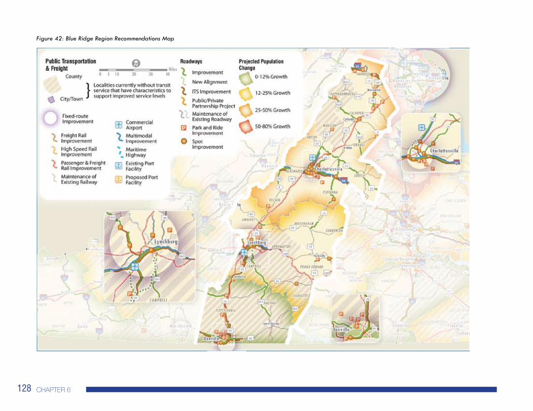
Figure 42: Blue Ridge Region Recommendations Map

2035 Virginia Surface TranSporTaTion plan �2�
puBliC transpOrtatiOn reCOmmendatiOnsIn the Blue Ridge Region, and across the entire state, Virginia’s public transportation systems must maintain a state of good repair for fleet vehicles and maintenance equipment. DRPT recognizes and prioritizes state of good repair issues through its asset management database and funding requirements. State of good repair is discussed in detail in Chapter 3 and funding is discussed in-depth in Chapter 5.
The northern portions of this region, namely the Rappahannock-Rapidan and Thomas Jefferson Planning Districts are expected to see a relatively high growth in population. The transit service improvements in these areas are intended to provide better transit service for commuting and daily trips to increase the mode share for transit, and promote strategies to reduce congestion, especially during peak hours. Recommendations in these areas are:
Focused Expansion of Fixed Route Coverage (e.g. improve and expand route service and implement express service in Charlottesville)Increased Transportation Demand Management
Similar to the Valley and Ridge Region, the population growth rate in the Blue Ridge region diminishes to the south. The Region 2000 and Virginia’s Heartland Planning Districts will experience slightly lower population growth rates. The recommendations for public transportation in these areas balance the need for fixed route service for commuters and those living in more densely populated areas, with the needs of the rural population and those who depend on human services transportation. The recommendations for these areas include:
Increased Demand Response ServiceExpanded Fixed Route Coverage (e.g. expanding bus and express bus service from Lynchburg to surrounding counties)Increase Transportation Demand Management
•
•
••
•
The southern jurisdictions of Pittsylvania County, the City of Danville and Halifax County are expected to have low population growth (based on projections at the PDC level). In these areas, the main focus of transit improvements is to address the mobility needs of older adults, persons with disabilities and persons with lower incomes. The recommendations in these areas include:
Introduction of Demand Response ServiceIncreased Human Services Transportation
In addition to the improvements listed above, the following jurisdictions do not currently have transit service and exhibit the population growth characteristics to support transit service:
Rappahannock CountyMadison CountyAppomattox CountyCampbell CountyCharlotte CountyPittsylvania CountyHalifax County
••
•••••••

chapTer 6�30
Transportation demand management strategies for the Blue Ridge Region are identified in Table 31.
The transit agencies in the Blue Ridge Region have the following ITS investment recommendations for the next six years (Table 32), as identified in the DRPT Statewide ITS Strategic Plan.
Table 31: TDM Strategies for the Blue Ridge Region
March 2010 DRAFT 7 55
GeographicSetting
Jurisdictions TDM Strategies
Smal
l Urb
an A
reas
Danville MPO, Lynchburg MPO,
Charlottesville MPO
Expand employer outreach, especially in suburban centers
Primary focus on resident / commute travel
Promote carpool and vanpool for long-distance commutes to areas outside region
Promote telework to residents
Develop transit links to urban and suburban employment
Integrate TDM into the land development processes; encourage mixed-use
Integrate TDM into local planning, MTPs, LRTPs
Enhance cross-jurisdictional coordination for TDM
Non
-Urb
an A
reas
All other areas
Primarily residence-based programs for commuting within and outside the area
Promote telework to residents
Establish modest commute outreach in areas with no current program
Support long-distance commute markets
Coordinate with neighboring employment areas for outbound commuting
Integrate TDM into local planning, MTPs, LRTPs
The transit agencies in the Blue Ridge Region have the following ITS investment recommendations for the next six years (Table 30), as identified in the DRPT Statewide ITS Strategic Plan.
Table 30: TDM Strategies for the Blue Ridge Region
Table 31: ITS Investments for the Blue Ridge Region

2035 Virginia Surface TranSporTaTion plan �3�
Table 32: ITS Investments for the Blue Ridge Region
March 2010 DRAFT 7 56
Transit Agency
ITS Investments in the Next 6 Years
Tran
sit O
pera
tions
Cust
omer
Am
eniti
es
Serv
ice
Plan
ning
Fare
Col
lect
ion
Secu
rity
Mai
nten
ance
/Man
agem
ent
Charlottesville Area Transit x x
Danville Transit
Farmville Area Bus x
Greater Lynchburg Transit Company x x x x
Greene County Transit, Inc. x x x x
JAUNT Inc. x x x x
Lake County Area Agency on Aging
Virginia Regional Transit x x x x x

chapTer 6�32
March 2010 DRAFT 7 57
I-81/Route 29 Intercity Passenger Rail Project
Phase I (Lynchburg)
Add one daily train between Washington, DC and Lynchburg Kemper Street Station as a demonstration project for three years beginning in 2009.
Increase commuter capacity in the VRE service area.
Complete the capacity study for the entire project corridor from Washington, DC to Bristol and Lynchburg.
Increase capacity for a second train to Lynchburg with construction of second main line track between Nokesville and Calverton.
Phase III (Bristol) and IV (Richmond) Provide train service from Bristol to Richmond and from Bristol to Washington, DC.
Table 32: Blue Ridge Region Rail RecommendationsTable 33: Rail Recommendations for the Blue Ridge Region
rail reCOmmendatiOns The rail recommendations for the Blue Ridge Region shown in Table 33 represent those projects within identified transportation corridors that will increase the freight shipments to and from ports, improve commuter and intercity rail within regions of the Commonwealth and other freight improvement projects identified by Class and shortline railroads in Virginia.
All improvements address one or more of the following:Reducing passenger car and truck freight traffic to alleviate highway congestion, reduce energy demands and reduce pollutantsIncreasing freight capacity throughout the Commonwealth to support greater demand for freight rail shipping, growth in the coal industry and improved capacity at Virginia’s portsImproving passenger rail by enhancing system performance and adding capacity
••
•

2035 Virginia Surface TranSporTaTion plan �33
_____________________________
27 Not all VTrans2035 goals were tied to specific recommended improvements. For the VTrans2035 goals of Linking Land Use and Transportation, Program Delivery, Environmental Stewardship, VDOT addresses compliance at the program level as discussed in Chapter 4 of the VSTP.
highway reCOmmendatiOns Route 29 serves as the primary north/ south corridor within the Blue Ridge Region, linking the metropolitan areas of Danville, Lynchburg and Charlottesville, as well as the towns of Culpeper and Warrenton. Facilities such as Routes 58, 460, 250 as well as Interstates 64 and 66 provide east/west connections. The areas along the Route 29 corridor represent the highest concentrations of population and employment within the region, with surrounding areas having a predominantly rural character. Highway recommendations within this region seek to provide greater access to the Charlottesville, Danville and Lynchburg areas, as well as provide additional capacity in the south to improve the economic competitiveness of this area of the Commonwealth. To the north, operational improvements including grade separation, signalization and access management to improve traffic flows are recommended to aid the commuter traffic to the Washington, DC, metropolitan area.
Park and Ride Recommendations: The Blue Ridge Region has approximately 28 existing Park and Ride facilities. Thirteen new facilities are recommended serving the City of Danville, City of Charlottesville, and Amherst, Nelson, Campbell, Appomattox, Orange, Madison, Franklin, Henry and Pittsylvania Counties. Additionally, four facilities in Rappahannock County and one facility in Fauquier County have been identified as needing expansion. Park and Ride recommendations are identified in Figure 42.
Other Recommendations: In addition to the Park and Ride recommendations, the multiple highway recommendations are shown in Figure 42 and listed in Tables 34 to 38. The Highway Recommendation Table Reference Guide (Figure 43) provides explanation of the multiple elements included in the highway recommendation tables. How the Recommendations are Organized: The highway recommendations presented in the 2035 Virginia Surface Transportation Plan address the performance measures presented in Chapter 4. These include: congestion; roadway capacity; safety; and maintenance. The highway recommendations
support the goals established in VTrans2035: Safety and Security; System Maintenance and Preservation; Mobility, Accessibility and Connectivity; Economic Vitality; Environmental Stewardship; and Coordination of Transportation and Land Use.27 The recommendations have been related to these goals in the tables that follow. The recommendations are presented in the following categories:
Recommendations to Existing Facilities – These recommendations represent improvements to the current roadway network. It is assumed any structures or interchanges that fall within the limits of the recommendation will be improved along with the roadway. It should also be noted that any recommendations identified as an improvement to 2 lanes denotes additional lane width to an existing 2-lane roadway.Recommendations to New Locations – These recommendations represent new facilities that would be added to the roadway network.Recommendations for Further Study – These are recommendations where a need has been identified, but alternatives are still being analyzed. Other Recommendations – These are recommendations that do not fall into the above categories. Examples include interchange and intersection improvements, standalone bridge replacements, re-striping and access management.ITS Recommendations – Intelligent Transportation System recommendations (as described in Chapter 4). Park and Ride Recommendations – These are recommendations for new Park and Ride lots or expansion to existing Park and Ride lots. Specifics for Park and Rides are not provided as each location will need to be studied to identify an appropriate location and level of demand.
•
•
•
•
•
•
chapTer 6�3�
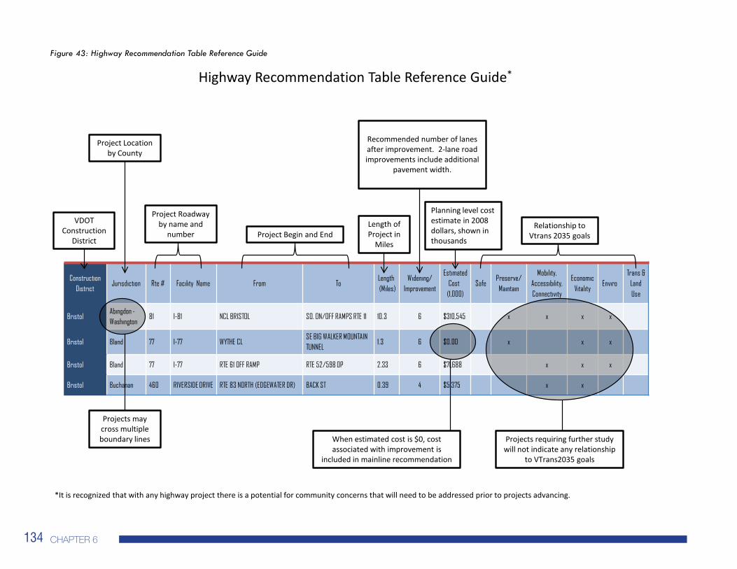
Figure 43: Highway Recommendation Table Reference Guide
Construction District
Jurisdiction Rte # Facility Name From ToLength(Miles)
Widening/ Improvement
Estimated Cost
(1,000)Safe
Preserve/Maintain
Mobility, Accessibility, Connectivity
Economic Vitality
EnviroTrans &
Land Use
BristolAbingdon -Washington
81 I-81 NCL BRISTOL SO. ON/OFF RAMPS RTE 11 10.3 6 $310,545 x x x x
Bristol Bland 77 I-77 WYTHE CLSE BIG WALKER MOUNTAIN TUNNEL
1.3 6 $0.00 x x x
Bristol Bland 77 I-77 RTE 61 OFF RAMP RTE 52/598 OP 2.33 6 $71,688 x x x
Bristol Buchanan 460 RIVERSIDE DRIVE RTE 83 NORTH (EDGEWATER DR) BACK ST 0.39 4 $5,375 x x
Length of Project in
Miles
Recommended number of lanes after improvement. 2-lane road improvements include additional
pavement width.
Planning level cost estimate in 2008 dollars, shown in thousands
Relationship to Vtrans 2035 goalsProject Begin and End
Projects requiring further study will not indicate any relationship
to VTrans2035 goals
Project Roadway by name and
number
Projects may cross multiple boundary lines
Project Location by County
VDOT Construction
District
*It is recognized that with any highway project there is a potential for community concerns that will need to be addressed prior to projects advancing.
Highway Recommendation Table Reference Guide*
When estimated cost is $0, cost associated with improvement is
included in mainline recommendation
2035 Virginia Surface TranSporTaTion plan �35
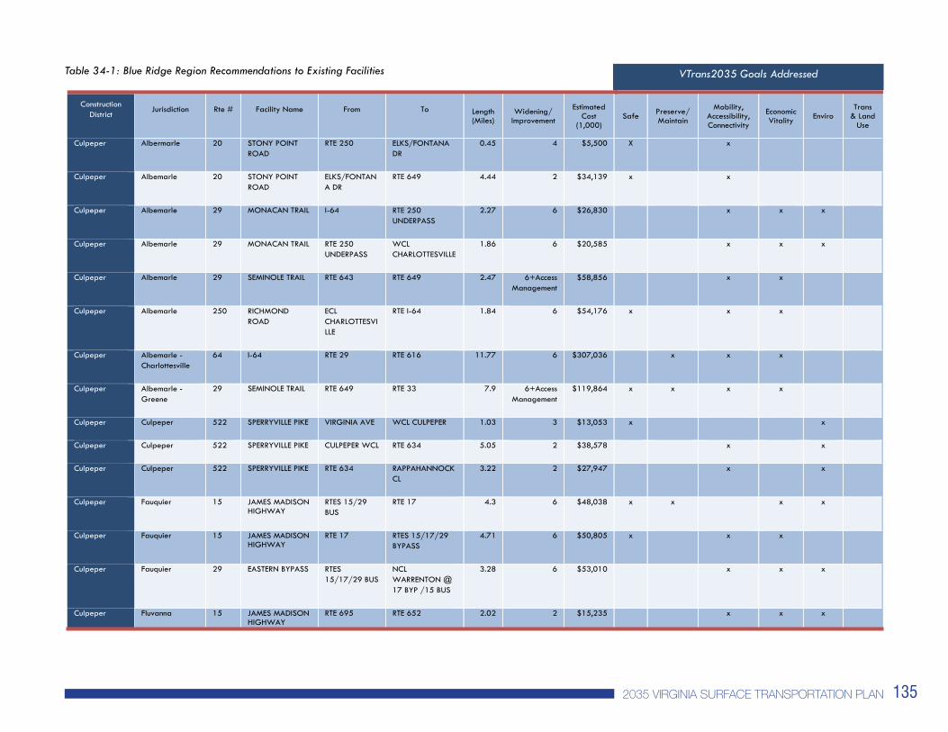
Table 34-1: Blue Ridge Region Recommendations to Existing Facilities
March 2010 DRAFT 7 60
Table 34-1: Blue Ridge Region Recommendations to Existing Facilities VTrans2035 Goals Addressed
Construction District
Jurisdiction Rte # Facility Name From To Length(Miles)
Widening/ Improvement
Estimated Cost
(1,000) Safe Preserve/
Maintain
Mobility, Accessibility, Connectivity
Economic Vitality Enviro
Trans & Land
Use
Culpeper Albermarle 20 STONY POINT ROAD
RTE 250 ELKS/FONTANA DR
0.45 4 $5,500 X x
Culpeper Albemarle 20 STONY POINT ROAD
ELKS/FONTANA DR
RTE 649 4.44 2 $34,139 x x
Culpeper Albemarle 29 MONACAN TRAIL I-64 RTE 250 UNDERPASS
2.27 6 $26,830 x x x
Culpeper Albemarle 29 MONACAN TRAIL RTE 250 UNDERPASS
WCLCHARLOTTESVILLE
1.86 6 $20,585 x x x
Culpeper Albemarle 29 SEMINOLE TRAIL RTE 643 RTE 649 2.47 6+Access Management
$58,856 x x
Culpeper Albemarle 250 RICHMOND ROAD
ECLCHARLOTTESVILLE
RTE I-64 1.84 6 $54,176 x x x
Culpeper Albemarle - Charlottesville
64 I-64 RTE 29 RTE 616 11.77 6 $307,036 x x x
Culpeper Albemarle - Greene
29 SEMINOLE TRAIL RTE 649 RTE 33 7.9 6+Access Management
$119,864 x x x x
Culpeper Culpeper 522 SPERRYVILLE PIKE VIRGINIA AVE WCL CULPEPER 1.03 3 $13,053 x x
Culpeper Culpeper 522 SPERRYVILLE PIKE CULPEPER WCL RTE 634 5.05 2 $38,578 x x
Culpeper Culpeper 522 SPERRYVILLE PIKE RTE 634 RAPPAHANNOCK CL
3.22 2 $27,947 x x
Culpeper Fauquier 15 JAMES MADISON HIGHWAY
RTES 15/29 BUS
RTE 17 4.3 6 $48,038 x x x x
Culpeper Fauquier 15 JAMES MADISON HIGHWAY
RTE 17 RTES 15/17/29 BYPASS
4.71 6 $50,805 x x x
Culpeper Fauquier 29 EASTERN BYPASS RTES 15/17/29 BUS
NCLWARRENTON @ 17 BYP /15 BUS
3.28 6 $53,010 x x x
Culpeper Fluvanna 15 JAMES MADISON HIGHWAY
RTE 695 RTE 652 2.02 2 $15,235 x x x
VTrans2035 Goals Addressed

chapTer 6�3�
Table 34-2: Blue Ridge Region Recommendations to Existing Facilities
March 2010 DRAFT 7 61
Table 34-2: Blue Ridge Region Recommendations to Existing Facilities
VTrans2035 Goals Addressed
Construction District
Jurisdiction Rte # Facility Name From ToLength(Miles)
Widening/ Improvement
Estimated Cost
(1,000) Safe
Preserve/Maintain
Mobility, Accessibility, Connectivity
Economic Vitality
Enviro Trans
& Land Use
Culpeper Fluvanna 15 JAMES MADISON HIGHWAY
RTE 702 RTE 250 16.5 2 $132,556 x x
Culpeper Louisa 15 JAMES MADISON HIGHWAY
RTE I-64 0.95 MI SOUTH OF RTE 617 (SOMMERFIELD DRIVE)
1.57 4 $34,353 x x
Culpeper Louisa 15 JAMES MADISON HIGHWAY
0.5 MI SOUTH OF RTE 617
ORANGE CL 8.99 2 $69,928 x
Culpeper Louisa 33 LOUISA RD -SOUTH SPOTSWOOD TRAIL
RTE 15 WCL LOUISA 12.12 2 $92,324 x
Culpeper Louisa 33 WEST MAIN ST WCL LOUISA RTE T- 669 0.64 3 $8,110 x x
Culpeper Louisa 33 WEST MAIN ST RTES 22/33 ECL LOUISA 0.97 3 $9,603 x x
Culpeper Louisa 33 JEFFERSON HIGHWAY
ECL LOUISA RTE 655 15.54 2 $118,955 x
Culpeper Louisa 208 ZACHARY TAYLOR HIGHWAY
RTE 522 SPOTSYLVANIA CL
3.62 4 $27,575 x
Culpeper Louisa 522 SANDY HOOK RD RTE 250 RTE I-64 0.52 4 $5,918 x x x
Culpeper Louisa 522 PENDELTON RD SCL MINERAL RTES 22/208 0.66 3 $7,841 x x
Culpeper Orange 522 ZACHARY TAYLOR HIGHWAY
.47 MI NORTH SPOTSLVANIA CL
CULPEPER CL 15.24 2 $122,129 x
Culpeper Orange - Albemarle
20 STONY POINT ROAD
RTE 649 RTE 33 WEST 9.96 2 $76,327
Culpeper Orange - Greene
33 SPOTSWOOD TRAIL
ROUTE 29 RTE 15 12.57 2 $138,145 x x
VTrans2035 Goals Addressed

2035 Virginia Surface TranSporTaTion plan �3�
Table 34-3: Blue Ridge Region Recommendations to Existing Facilities
March 2010 DRAFT 7 62
Table 34-3: Blue Ridge Region Recommendations to Existing Facilities VTrans2035 Goals Addressed
Construction District
Jurisdiction Rte # Facility Name From ToLength(Miles)
Widening/ Improvement
Estimated Cost
(1,000) Safe
Preserve/Maintain
Mobility, Accessibility, Connectivity
Economic Vitality
Enviro Trans
& Land Use
Culpeper Rappahannock 522 ZACHARY TAYLOR AVE - SPERRYVILLE PIKE
CULPEPER CL RTE 1001 9.35 2 $74,844 x
Lynchburg Amherst 29 LYNCHBURG EXPRESSWAY
RTE 163 (AMHERST ST)
RTE 163 NORTH AT LYTTLETON (1040)
0.52 4 $12,000 x x
Lynchburg Amherst 60 RICHMOND HIGHWAY
RTE 29 BYPASS AMHERST ECL / RTE 606 WEST
0.93 2 $6,492 x x x
Lynchburg Amherst 60 RICHMOND HIGHWAY
AMHERST ECL / RTE 606 WEST
RTE 600 3.29 2 $49,837 x x x
Lynchburg Buckingham 15 JAMES MADISON HIGHWAY - OAK ST
RTE 60 RTE T-1010 EAST 2.11 4 $21,244 x x x x
Lynchburg Buckingham 15 JAMES MADISON HIGHWAY
NCL DILLWYN RTE 617 SOUTH 3.82 2 $27,559 x x x x
Lynchburg Campbell 501 BROOKNEAL HIGHWAY - LUSARDI DR - LYNCHBURG AVE
HALIFAX CL RTE 622 20.86 3 $201,696 x x x
Lynchburg Campbell 501 CAMPBELL HIGHWAY
RTE 24 EAST RTE 680 NORTH 2.22 4 $32,492 x x X x
Lynchburg Campbell – Lynchburg
460 LYNCHBURG HIGHWAY – RICHMOND HIGHWAY
WATERLICK RD ROUTE 501 SOUTH
5.10 6 $58,563 x x x
Lynchburg Cumberland 60 JAMESANDERSON HIGHWAY
RTE 600 EAST RTE 13 1 4 $19,026 x x x
Lynchburg Danville 58 SOUTH BOSTON RD
RTE 29 NORTH KENTUCK ROAD 0.9 6 $19,575 x x
VTrans2035 Goals Addressed

chapTer 6�3�
Table 34-4: Blue Ridge Region Recommendations to Existing Facilities
March 2010 DRAFT 7 63
Table 34-4: Blue Ridge Region Recommendations to Existing Facilities VTrans2035 Goals Addressed
Construction District
Jurisdiction Rte # Facility Name From ToLength(Miles)
Widening/ Improvement
Estimated Cost
(1,000) Safe
Preserve/Maintain
Mobility, Accessibility, Connectivity
Economic Vitality
Enviro Trans
& Land Use
Lynchburg Halifax 40 STAGE COACH RD
RTE 670 RTE 501 7.94 2 $54,915 x
Lynchburg Halifax 40 L P BAILEY MEMORIAL HIGHWAY
RTE 501 CAMPBELL CL 0.97 3 $8,366 x x x
Lynchburg Halifax 501 L P BAILEY MEMORIAL HIGHWAY
RTE 360 ALT EAST
RTE 40 20.55 2 $148,365 x
Lynchburg Lynchburg 501 CANDLERS MOUNTAIN ROAD
RTE 460 SOUTH
LYNCHBURG EXPRESSWAY
0.99 6 $23,068 x x x
Lynchburg Lynchburg 501 LYNCHBURG EXPRESSWAY
LAKESIDE DRIVE
BOONSBORO ROAD
3.4 4 $36,157 x x x x
Lynchburg Lynchburg 460 RICHMOND HIGHWAY
RTE 501 SOUTH
ECL LYNCHBURG 4.47 6 $56,399 X X X
Lynchburg Nelson 151 ROCKFISH VALLEY HIGHWAY
RTE 6 SOUTH ALBEMARLE CL 7.63 2 $54,177 x x x
Lynchburg Pittsylvania 40 OLD FRANKLIN TURNPIKE
RTE 876E RTE 29 BYPASS 23.17 2 $243,888 x
Lynchburg Prince Edward 15 FARMVILLE RD RTE 133 RTE 628 2.65 4 $25,010 x x x x
Lynchburg - Culpeper - Staunton
Augusta - Albemarle - Nelson
64 I-64 ECLWAYNESBORO
RTE 250 9.95 6 $223,748 x
Lynchburg - Richmond
Prince Edward – Nottoway - Amelia
307 HOLLY FARM RD RTE 460 RTE 360 9.32 3 $83,942 x x
VTrans2035 Goals Addressed

2035 Virginia Surface TranSporTaTion plan �3�
Table 35: Blue Ridge Region Recommendations to New Locations
Table 36: Blue Ridge Region Recommendations to New Locations Identified for Further Study
*Recommendations have not been related to VTrans2035 goals as projects require further study
March 2010 DRAFT 7 64
Table 35: Blue Ridge Region Recommendations to New Locations VTrans2035 Goals Addressed
Construction District
Jurisdiction Rte # Facility Name From To Length(Miles)
Widening/Improvement
Estimated Cost (1,000)
Safe Preserve/Maintain
Mobility, Accessibility, Connectivity
EconomicVitality
Enviro Trans & Land
Use
Lynchburg Campbell 29 ROUTE 29 BYPASS SOUTH
US HWY 460 ROUTE 29 9.99 4 $120,505 x x x
Lynchburg Campbell 29 ROUTE 29 ALTERNATE
ROUTE 29 (SOUTH OF YELLOWBRANCH)
2 MI SOUTH OF ROUTE 460
5.00 4 $150,313 x x x
Lynchburg Campbell 29 ROUTE 29 ALTERNATE
2 MI SOUTH OF ROUTE 460
ROUTE 460 2.00 4 $54,125 x x x
Lynchburg Lynchburg 501 LYNCHBURG EXPRESSWAY
EXISTING ROUTE 501 SOUTH OF 221
NORTHWEST EXPRESSWAY
0.51 4 $37,383 x x
Table 36: Blue Ridge Region Recommendations to New Locations Identified for Further Study VTrans2035 Goals Addressed*
Construction District
Jurisdiction Rte # Facility Name From To Length(Miles)
Widening/Improvement
Estimated Cost (1,000)
Safe Preserve/Maintain
Mobility, Accessibility, Connectivity
EconomicVitality
Enviro Trans & Land
Use
Culpeper Albemarle 29 RTE 29 BYPASS RTE 29 RTE 29 0.5 MN N. RIVANNA RIVER
6.4 4 $234,600
Culpeper Fauquier 66 I-66 RTE 17/55 EAST
PRINCE WILLIAM CL
12.76 TBD TBD
Culpeper-Staunton
Warren - Fauquier
66 I-66 I-81 NB ON RAMP
RTE 17/55 EAST 23.83 TBD TBD
Lynchburg Prince Edward 15 RTE 628 RTES 460/15 BUS EAST
Study as potential STARS project.
$0
*Does not address any VTrans2035 goals because projects require further study
VTrans2035 Goals Addressed
VTrans2035 Goals Addressed *
chapTer 6��0
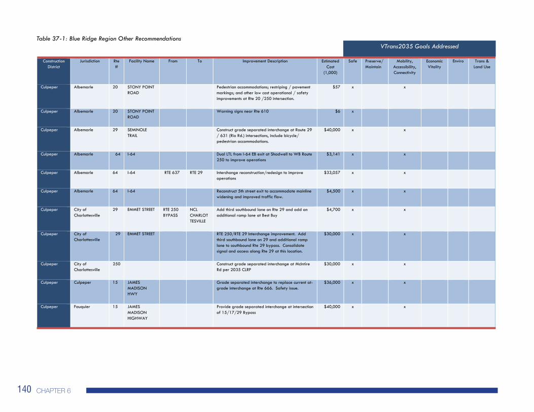
Table 37-1: Blue Ridge Region Other Recommendations
March 2010 DRAFT 7 65
Table 37-1: Blue Ridge Region Other Recommendations VTrans2035 Goals Addressed
Construction District
Jurisdiction Rte #
Facility Name From To Improvement Description Estimated Cost
(1,000)
Safe Preserve/Maintain
Mobility, Accessibility, Connectivity
EconomicVitality
Enviro Trans & Land Use
Culpeper Albemarle 20 STONY POINT ROAD
Pedestrian accommodations; restriping / pavement markings; and other low cost operational / safety improvements at Rte 20 /250 intersection.
$57 x x
Culpeper Albemarle 20 STONY POINT ROAD
Warning signs near Rte 610 $6 x
Culpeper Albemarle 29 SEMINOLE TRAIL
Construct grade separated interchange at Route 29 / 631 (Rio Rd.) intersections, include bicycle/ pedestrian accommodations.
$40,000 x x
Culpeper Albemarle 64 I-64 Dual LTL from I-64 EB exit at Shadwell to WB Route 250 to improve operations
$3,141 x x
Culpeper Albemarle 64 I-64 RTE 637 RTE 29 Interchange reconstruction/redesign to improve operations
$33,057 x x
Culpeper Albemarle 64 I-64 Reconstruct 5th street exit to accommodate mainline widening and improved traffic flow.
$4,500 x x
Culpeper City of Charlottesville
29 EMMET STREET RTE 250 BYPASS
NCLCHARLOTTESVILLE
Add third southbound lane on Rte 29 and add an additional ramp lane at Best Buy
$4,700 x x
Culpeper City of Charlottesville
29 EMMET STREET RTE 250/RTE 29 Interchange improvement. Add third southbound lane on 29 and additional ramp lane to southbound Rte 29 bypass. Consolidate signal and access along Rte 29 at this location.
$30,000 x x
Culpeper City of Charlottesville
250 Construct grade separated interchange at McIntire Rd per 2035 CLRP
$30,000 x x
Culpeper Culpeper 15 JAMESMADISON HWY
Grade separated interchange to replace current at-grade interchange at Rte 666. Safety issue.
$36,000 x x
Culpeper Fauquier 15 JAMESMADISON HIGHWAY
Provide grade separated interchange at intersection of 15/17/29 Bypass
$40,000 x x
VTrans2035 Goals Addressed
VTrans2035 Goals Addressed

2035 Virginia Surface TranSporTaTion plan ���
Table 37-2: Blue Ridge Region Other Recommendations
March 2010 DRAFT 7 66
Table 37-2: Blue Ridge Region Other Recommendations
Construction District
Jurisdiction Rte #
Facility Name From To Improvement Description Estimated Cost
(1,000)
Safe Preserve/Maintain
Mobility, Accessibility, Connectivity
Economic Vitality
Enviro Trans & Land Use
Culpeper Fauquier 29 LEE HIGHWAY Construct grade separated interchange at Route 29/215 interchange
$35,000 x x
Culpeper Fluvanna 15 JAMESMADISON HWY
Intersection improvement at intersection of Route 15 and 6. Reconstruct intersection as one lane roundabout.
$1,000 x
Culpeper Louisa 64 I-64 Improve interchange at Route 15. Ramp improvements needed to handle future traffic volumes expected for this high growth area.
$5,000 x x x
Lynchburg Amherst 29 LYNCHBURG EXP.
Construct interchange at Route 163 to allow all movements. Lynchburg Vision CLRP recommendation.
$12,000 x x
Lynchburg Campbell 29 WARDS RD ENGLISH TAVERN ROAD
LAWYERS ROAD
Add street names to mast arms, check clearance level for the traffic signal, move stop bar and install pork chop island at Wards Road / English Tavern Road.
$20 x x x x
Lynchburg Campbell 29 WARDS RD LAWYERS ROAD
AIRPORT ENTRANCE
Close median openings in various locations on Wards Road near Russel Woods Drive
$50 x x x x
Lynchburg Charlotte 40 THOMAS JEFFERSON HWY
Provide additional turning radius for large trucks at Route 40 / 47 intersection. Recommendation from Commonwealth Regional Council.
$500 x
Lynchburg City of Danville 29 DANVILLE EXPRESSWAY
Construct bridge structure and ramps for interchange at Elizabeth St.
$4,820 x x
Lynchburg City of Danville 29 DANVILLE EXPRESS.
RTE 58 NCLDANVILLE
Upgrade to interstate standards & number Interstate 785. Minor signage and spot improvement needed
$924 x x
Lynchburg City of Danville 58 SOUTH BOSTON RD/RIVERSIDE DR
RTE 29 NORTH
PIEDMONT DR
Implement access management along corridor as recommended by Danville 2030 CLRP (Vision).
$9,000 x x x x
Lynchburg City of Lynchburg
460 RICHMOND HIGHWAY
Lengthen acceleration lane onto Rt 29 N. Route 460 from Route 501.
$5,000 x x
VTrans2035 Goals Addressed

chapTer 6��2
Table 37-3: Blue Ridge Region Other Recommendations
March 2010 DRAFT 7 67
Table 37_3: Blue Ridge Region Other Recommendations VTrans2035 Goals Addressed
Construction District
Jurisdiction Rte #
Facility Name From To Improvement Description Estimated Cost
(1,000)
Safe Preserve/Maintain
Mobility, Accessibility, Connectivity
Economic Vitality
Enviro Trans & Land Use
Lynchburg City of Lynchburg
501 LYNCHBURG EXPRESSWAY
Construct interchange at Route 221 (Lakeside Dr.) as noted in Lynchburg 2030 CLRP
$42,000 x
Lynchburg Pittsylvania 29 DANVILLE EXPRESSWAY
NCLDANVILLE
ROUTE 863
Upgrade to interstate standards & number Interstate 785. Minor signage and spot improvements needed.
$1,168 x x
Lynchburg Pittsylvania 29 RTE 703
RTE 29 SOUTH BUSINESS
Provide access management improvements in the vicinity of Tightsqueeze Rd are of Pittsylvania Co. Recommendations from Rt. 29 Access Management study.
$5,000 x x
Lynchburg Pittsylvania 58 ROUTE 708 EAST
RTE 58 BUSINESS
Implement access management along corridor as recommended by Danville 2030 CLRP (Vision).
$2,000 x x x x
Lynchburg Pittsylvania 58 SOUTH BOSTON RD
ECLDANVILLE
RTE 62 Implement access management along corridor as recommended by Danville 2030 CLRP (Vision).
$5,000 x x x x
Lynchburg Pittsylvania 58 RIVERSIDE DR RTE 58 BYPASS/WBRAMP
WCLDANVILLE
Implement access management along corridor as recommended by Danville 2030 CLRP (Vision).
$2,000 x x x
Lynchburg Prince Edward 307 HOLLY FARM RD
At intersection of Rtes 307 and 460. Recommended for STARS study.
$0 x x
VTrans2035 Goals Addressed

2035 Virginia Surface TranSporTaTion plan ��3
Table 38: Blue Ridge Region ITS Recommendations (A description of ITS project types can be found on pp. 59-60)
March 2010 DRAFT 7 68
Table 38: Blue Ridge Region ITS Recommendations (A description of ITS project types can be found on pp. 4-7 and 4-8) VTrans2035 Goals Addressed
Route Limits Short-Term (0-7 years)
Mid-Term (8-15 years)
Long-Term (16-25 years)
Other Safe Preserve/Maintain
Mobility, Accessibility, Connectivity
EconomicVitality
Enviro Trans & Land Use
I-66 Rt.15 to I-81 Traffic Detection & Monitoring
Intellidrive x x x
I-64 MP 87 to MP 136
Traveler Information
Intellidrive Climbing lanes from MP 97 to MP 104
x x x
I-64 ATM x x x
I-64 CVO x x x
I-64 Entire Length Core Infrastructure ICM SLCS x x x
I-64 ATM Intellidrive x x x
US 29 Pittsylvania Emergency Operations and Traveler Information (Closed Circuit TV and Changeable Message Signs)
x x x
US 29 Lynchburg - Campbell
Emergency Operations and Traveler Information (Closed Circuit TV and Changeable Message Signs)
x x x
US 58 Pittsylvania Emergency Operations and Traveler Information (Closed Circuit TV and Changeable Message Signs)
x x x
US 460 Lynchburg - Campbell
Emergency Operations and Traveler Information (Closed Circuit TV and Changeable Message Signs)
x x x
US 501 Lynchburg Emergency Operations and Traveler Information (Closed Circuit TV and Changeable Message Signs)
x x x
VTrans2035 Goals Addressed