Regina International Airport Airport Master Plan 2007 … · AIRPORT MASTER PLAN 2007-2027 –...
223
October, 2008 PSMI No. 10959 Pryde Schropp McComb Inc. Regina International Airport Airport Master Plan 2007-2027
-
Upload
phamnguyet -
Category
Documents
-
view
231 -
download
1
Transcript of Regina International Airport Airport Master Plan 2007 … · AIRPORT MASTER PLAN 2007-2027 –...
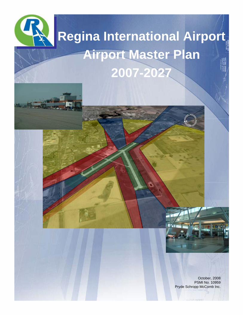
October, 2008PSMI No. 10959
Pryde Schropp McComb Inc.
Regina International AirportAirport Master Plan
2007-2027
AIRPORT MASTER PLAN 2007-2027 – REGINA INTERNATIONAL AIRPORT REGINA, SK –FINAL REPORT
October, 2008 ES-1 Pryde Schropp McComb, Inc./SEA/DMA/SCOTT
EXECUTIVE SUMMARY
In the fall of 2007, the Regina Airport Authority (RAA) commissioned the consulting team of Pryde Schropp McComb, Inc., Saunders Evans Architects Inc, SCOTT Associates Architects, Inc. and Derek Murray Consulting and Associates to update the Airport Master Plan. The Airport Master Plan is intended to be a blueprint for future development of the Regina International Airport (YQR), which is managed and operated by the Regina Airport Authority (RAA). This plan is a description of the most appropriate development options regarding land use, facilities, and services required to ensure YQR meets its strategic objectives and accommodates expected levels of traffic over the next 20 years. It builds upon the previous Land Use and is guided by the progressive efforts of the RAA since taking over the operation of the facility in 1999. The Airport Master Plan also serves to address the requirements of the Transport Canada Ground Lease Agreement which requires periodic reviews and updates to the Airport Master Plan at ten (10) year intervals.
The Airport Master Plan involves a planning process that looks 20 years into the future and in this case is intended to capture the period 2007 to 2027. It has to provide forward thinking and progressive initiatives, and be sensitive to current fiscal, environmental and community needs. Consultation with stakeholders, as well as government, industry, and related community interests has been an integral part of its preparation.
This Airport Master Plan put particular emphasis on exploring groundside development and strategic business development while protecting the core aeronautical business. The overriding objectives of the RAA are to diversify its revenue base to better manage future variability in the airline industry and to address an apparent interest in commercial development at the airport based on increased inquiries over the last year.
It should be noted that the Airport Master Plan is not:
• A prescribed schedule of development.
• An engineering and technical study.
• A commitment of funding.
• A project definition report.
While the report provides a much greater level of detail of the various recommendations made, the following abbreviated list was intended to capture the key strategic recommendations for implementation by the RAA over the master planning period:
• Prioritize airside improvements to focus on customer service including:
• Additional Air Bridges and Main Apron I/II Expansion North and South
AIRPORT MASTER PLAN 2007-2027 – REGINA INTERNATIONAL AIRPORT REGINA, SK – FINAL REPORT
Pryde Schropp McComb, Inc. ES-2 October, 2008
• Air Terminal Building enhancements including widening of the building by about 9m to better manage the current air passenger peaks and to address the long-term growth in passenger volumes.
• Groundside improvements including parking lot expansions, approach road enhancements and increased terminal curbside lane lengths.
• The RAA should continue to protect their airside and groundside assets through routine rehabilitation and maintenance.
• The RAA should continue to promote its ability to serve the cargo market and to work with the City of Regina in its industrial growth initiatives.
• The RAA should develop a strategic plan for its new groundside commercial development areas.
• This RAA should use this updated Airport Master Plan to update their corporate Strategic Plan and Capital Planning initiatives.
• The RAA should use this Airport Master Plan and its recommendation to continue their cooperative relationships with the City of Regina and the RM Sherwood.
• The RAA should submit this Airport Master Plan and associated updated 2027 Airport Land Use Plan to Transport Canada in accordance with the terms of the Federal Ground Lease Agreement.
Exhibits 7 and 13 appended to this Executive Summary present the 2027 Long-term Airport Development Concept and the 2027 Airport Land Use Plan.
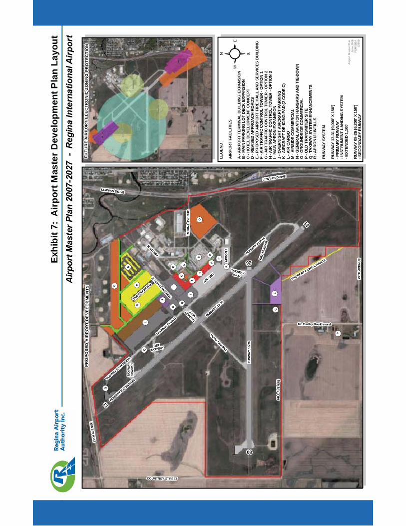
Airp
ortM
aste
rPla
n20
07-2
027
-R
egin
aIn
tern
atio
nalA
irpor
tEx
hibi
t7:
Airp
ortM
aste
rDev
elop
men
tPla
nLa
yout
RU
NW
AY
08-2
6
RUNWAY 13-31
APRON I
TAXIW
AY BRAVO
TAXIW
AY ALPHA
TAXIW
AYCHARLIE
TAXIW
AYPAPA
APR
ON
II
APRON
III
TAXIW
AY
MIKE
Airp
ortM
aste
rPla
nJu
ne20
08PS
MI/S
EA10
959
LEGE
ND
AIRP
ORT
FACI
LITI
ES
A-A
IRPO
RTTE
RMIN
ALBU
ILDI
NGEX
PANS
ION
B-M
AIN
PARK
ING
LOT
DECK
EXPA
NSIO
NC
-HO
TEL
DEVE
LOPM
ENT
CONC
EPT
D-R
EVIS
EDAP
PRO
ACH
ROAD
SE
-PR
OPO
SED
AIRP
ORT
FIRE
HALL
AND
SERV
ICES
BUIL
DIN
GF
-AIR
TRAF
FIC
CON
TRO
LTO
WER
-OPT
ION
1G
-AIR
TRAF
FIC
CON
TRO
LTO
WER
-OPT
ION
2H
-AIR
TRAF
FIC
CONT
ROL
TOW
ER-O
PTIO
N3
I-M
AIN
APRO
NEX
PANS
ION
J-O
VERN
IGHT
AIRC
RAFT
PARK
ING
K-A
IRCR
AFT
DE-IC
ING
PAD
(2CO
DEC)
L-A
IRCA
RGO
M-A
IRSI
DECO
MM
ERCI
ALN
-GEN
ERAL
AVIA
TION
HANG
ARS
AND
TIE-
DOW
NO
-GRO
UNDS
IDE
COM
MER
CIAL
P-O
LDTR
ANSM
ITER
SITE
Q-T
AXIW
AYSY
STEM
ENHA
NCEM
ENTS
R-A
PRO
NI/I
IINF
ILLS
RUNW
AYSY
STEM
RUNW
AY13
-31
(9,0
00'X
150'
)-P
RIM
ARY
RUNW
AY-I
NSTR
UMEN
TLA
NDIN
GSY
STEM
-EXT
ENDE
D1,
100'
RUNW
AY08
-26
(6,2
00'X
150'
)-S
ECO
NDAR
YR
UNW
AY
! (A
! (B
! (C
TAXIWAYKILO! (H
! (F
! (E
! (D
RETTAXIWAY
! (G
RET
TAXI
WAY
TAXIW
AY ECHO
TAXIW
AY EXTENSION
RUNWAY EXTENSION
! (D
! (D
! (I
! (I
! (J
! (K
! (L
! (M! (M
! (N
! (O
LEWVAN DRIVE
LEWVAN DRIVE
13TH
AVEN
UE
25TH
AVE
NU
E
HIL
LA
VEN
UE
COURTNEY STREET
REG
INA
AVE
NU
E
Mc Carthy Bouldevard
3113
26
08
! (P
²
FUTU
RE
AIR
PO
RT
ELEC
TRO
NIC
ZON
ING
PRO
TEC
TIO
NPR
OPO
SED
AIR
POR
TD
EVE
LOP
ME
NTS
! (O
TAX
IWAY
BR
AVO
1
PROPERTY LINE CHANGE
! (R
! (R
! (Q
! (Q
! (Q

Airp
ortM
aste
rPla
n20
07-2
027
-R
egin
aIn
tern
atio
nalA
irpor
tEx
hibi
t13:
2007
-202
7A
irpor
tLan
dU
sePl
an
RU
NW
AY
08-2
6
RUNWAY 13-31
APRON I
TAXIW
AY BRAVO
TAXIW
AY ALPHA
TAXIW
AYCHARLIE
TAXIW
AYPAPA
APR
ON
II
APRON
III
TAXIW
AY
MIKE
Airp
ortM
aste
rPla
nJu
ne20
08PS
MI/S
EA10
959
²LE
GEND
AIRP
ORT
LAN
DUS
EDE
SIG
NATI
ONS
AIR
SIDE
SYST
EM
AIR
TERM
INAL
BUIL
DING
RESE
RVE
GRO
UND
TRAN
SPO
RTAT
ION
SYST
EMRE
SERV
E
OPE
RATI
ONS
FACI
LITI
ESRE
SERV
E
AIR
PORT
SUPP
ORT
FACI
LITI
ESR
ESER
VES
AIR
SIDE
COM
MER
CIA
LRE
SERV
ES
GRO
UNDS
IDE
COM
MER
ICAL
RESE
RVES
AIR
CARG
ORE
SERV
E
AIR
PORT
RESE
RVES
TAXIWAYKILO
RET TAXIWAY
RET
TAXI
WAY
TAXIW
AY ECHO
TAXIW
AY EXTENSION
RUNWAY EXTENSION
LEWVAN DRIVE
LEWVAN DRIVE
13TH
AVEN
UE
25TH
AVE
NU
E
HIL
LA
VEN
UE
COURTNEY STREET
Mc Carthy Bouldevard
REG
INA
AVE
NU
E
AER
ON
AU
TIC
AL
PR
OTE
CTI
ON
AR
EAS
15km
15km
4km
Rad
ius

AIRPORT MASTER PLAN 2007-2027 – REGINA INTERNATIONAL AIRPORT REGINA, SK –FINAL REPORT
October, 2008 i Pryde Schropp McComb, Inc./SEA/DMA/SCOTT
Table of Contents Page
1.0 INTRODUCTION 1
1.1 General 1
1.2 Guiding Principles and Objectives of the Airport Master Plan 2
1.3 Airport Role and Economic Benefits 3
1.4 Regina Airport Authority and the Airport Master Plan 5
1.5 Previous Relevant Studies 8
1.6 Summary of Key Recommendations 9
2.0 EXISTING AIRPORT OVERVIEW 11
2.1 General 11
2.2 History 11
2.3 Airport Overview 12
2.4 Aeronautical Zoning 13
2.5 Airport Interface with the Community 18
2.6 RAA Community Interface Initiatives 22
3.0 SOCIO-ECONOMIC ENVIRONMENT, AVIATION ACTIVITY AND FORECASTS 23
3.1 Socio-Economic Environment 23
3.2 Passenger Traffic Forecast 32
3.3 Cargo Forecast 42
3.4 Aircraft Activity 43
3.5 Aircraft Movements Forecast 2007-2027 49
3.6 Peak Hour Activities 58
3.7 Summary of Key Forecasting Recommendations 64
4.0 CONSTRAINTS & OPPORTUNITIES (AIRSIDE AND GROUNDSIDE) 67
5.0 AIRFIELD ANALYSIS 69
5.1 General 69
5.2 Guiding Principles 69
5.3 Current Airfield Facilities 70
AIRPORT MASTER PLAN 2007-2027 – REGINA INTERNATIONAL AIRPORT REGINA, SK –FINAL REPORT
October, 2008 ii Pryde Schropp McComb, Inc./SEA/DMA/SCOTT
Table of Contents (Continued) Page
5.4 Airport Usability 71
5.5 Runway System Capacity 75
5.6 Runway 13-31 Extension 77
5.7 Taxiway and Apron Systems 78
5.8 Summary of Key Recommendations 79
6.0 AIR TERMINAL BUILDING COMPLEX 81
6.1 Summary of Analysis 81
6.2 Master Plan Concept 2027 Recommendations 81
6.3 Master Plan Concept 2027 Recommended Phasing 82
7.0 AIR CARGO 85
7.1 General 85
7.2 Current Facilities 85
7.3 Summary of Key Recommendations: 86
8.0 AIRSIDE COMMERCIAL 89
8.1 General 89
8.2 Summary of Key Recommendations 89
9.0 AIRSIDE OPERATIONS AND SUPPORT 91
9.1 General 91
9.2 Air Traffic Control Services 91
9.3 Aircraft Rescue Fire Fighting (ARFF) 91
9.4 Aircraft De-Icing 92
9.5 Aircraft Fuelling 92
9.6 Snow Clearing and Maintenance 92
9.7 Utilities 93
9.8 Summary of Key Recommendations 93
AIRPORT MASTER PLAN 2007-2027 – REGINA INTERNATIONAL AIRPORT REGINA, SK –FINAL REPORT
October, 2008 iii Pryde Schropp McComb, Inc./SEA/DMA/SCOTT
Table of Contents (Continued) Page
10.0 GROUNDSIDE COMMERCIAL DEVELOPMENT 96
10.1 General 96
10.2 Guiding Principles 96
10.3 Regina International Airport Advantages 97
10.4 Existing Groundside Commercial Development 98
10.5 New Groundside Development Recommendations 100
10.6 Site Development Strategies (Guidelines) 103
10.7 Summary of Key Recommendations 105
11.0 GROUNDSIDE ACCESS AND SERVICING 107
11.1 Guiding Principles 107
11.2 Current Ground Transportation Facilities 107
11.3 Existing Groundside Access and Circulation 107
11.4 Future Airport Access and Circulation Requirements 110
11.5 Airport Access recommendations 110
11.6 Existing Parking Facilities 112
11.7 Future Parking Requirements 112
11.8 Air Terminal Building Parking Recommendations 113
11.9 Public Transit 120
11.10 Summary of Key Recommendations 120
12.0 ENVIRONMENT 123
12.1 General 123
12.2 RAA Environmental Policy 123
12.3 Environmental Practices 124
12.4 Air Quality 126
12.5 Aircraft Noise 130
12.6 Summary of Key Recommendations 134
AIRPORT MASTER PLAN 2007-2027 – REGINA INTERNATIONAL AIRPORT REGINA, SK –FINAL REPORT
October, 2008 iv Pryde Schropp McComb, Inc./SEA/DMA/SCOTT
Table of Contents (Continued) Page
13.0 COMMUNITY INTERFACE 135
13.1 Community Consultative Committee 135
13.2 Aeronautical Zoning 135
13.3 Municipal Interface 135
13.4 Summary of Key Recommendations: 137
14.0 AIRPORT LAND USE PLAN 2027 139
14.1 General 139
14.2 Guiding Principles 139
14.3 Airport Development Concept Plan 2027 139
14.4 Regina International Airport Land Use Plan 2027 140
GLOSSARY OF AVIATION TERMS 145
LIST OF EXHIBITS (APPENDED AFTER GLOSSARY OF AVIATION TERMS) Exhibit 1 Airport Location and Existing Conditions Exhibit 2 Operational Aeronautical Zoning Exhibit 3 Operational Electronic Zoning Exhibit 4 Airport and Surrounding Municipal Land Use Exhibit 5 Airport Noise Exposure Contours – 2024 NEF Exhibit 6 Airport Development Constraints and Opportunities Exhibit 7 Airport Master Development Plan Layout Exhibit 8 Proposed Air Terminal Expansion Concept – First Floor Exhibit 9 Proposed Air Terminal Expansion Concept – Second Floor Exhibit 10 Proposed ATB Expansion Phasing – First Floor Exhibit 11 Proposed ATB Expansion Phasing – Second Floor Exhibit 12 Proposed Groundside Commercial Development Concepts Exhibit 13 2007-2027 Airport Land Use Plan
LIST OF FIGURES Figure 1-1 1998 Transport Canada Land Use Plan (At time of Transfer) 1Figure 1-2 2021 Airport Master Plan (Approved by the Board of Directors in 2002): 2Figure 1-3 Regina International Airport Catchment Area 4Figure 1-4 Airport Master Plan and Implementation Hierarchy 7Figure 2-1 Federal Airport Zoning Regulations (AZR) – 4 km Radius 16Figure 2-2 Federal Airport Zoning Regulations (AZR) – 15 km Runway Protection 17
AIRPORT MASTER PLAN 2007-2027 – REGINA INTERNATIONAL AIRPORT REGINA, SK –FINAL REPORT
October, 2008 v Pryde Schropp McComb, Inc./SEA/DMA/SCOTT
Table of Contents (Continued) Page
Figure 2-3 Preferred Industrial Growth Option (B) 20 Figure 2-4 City and Regional Road Network Plan (B) 21Figure 3-1 City of Regina Regional Situation 23Figure 3-2 Projected Unemployment (2007-2011) 26Figure 3-3 Productivity Average (2007-2011) 27Figure 3-4 Average Job Tenure 28Figure 3-5 Saskatchewan 2006 Real GDP by Industry 29Figure 3-6 GDP Average % Change 30Figure 3-7 Enplaned and Deplaned Passengers 33Figure 3-8 Comparative forecast results 37Figure 3-9 Passengers, GDP and Population growth 39Figure 3-10 Annual Enplaned and Deplaned Passenger Forecasts 42Figure 3-11 Aircraft Movements – Regina Airport 44Figure 3-12 Regina Itinerant Movements-Comparison with Canada 1996-2006 46Figure 3-13 Regina Airport Itinerant Movements 1996-2006 48Figure 3-14 Regina Airport Local Movements 49Figure 3-15 Scheduled And Smaller Carriers Medium Forecast 2007-2027 52Figure 3-16 Other Itinerant Movements Forecast Medium Scenario 2007-2027 54Figure 3-17 Regina Airport Local Movements Medium Scenario 2007-2027 56Figure 3-18 Regina Aircraft Movement Forecasts Medium Scenario 2007-2027 58Figure 3-19 Level I-III Aircraft Movements per month 2006 and 2007 59Figure 3-20 Scheduled and Charter Arrivals Thursday in January 60Figure 3-21 Regina Scheduled and Charter Departures Thursday in January 61Figure 3-22 Total Movements Per Hour 62Figure 5-1 Runway Arrival Distribution 72Figure 5-2 Runway Departure Distribution 73Figure 5-3 Future ILS Runway 31 Glidepath Protection Area (Threshold 31) 75Figure 5-4 Regina International Airport Chart Summary of PPHM Scenarios and Capacities 77Figure 10-1 Regina International Airport within City Context 97Figure 10-2 Existing Groundside Development and Recommended Infill 98Figure 10-3 South Groundside Commercial Space 101Figure 10-4 Groundside Expansion Northern Airport Lands 101Figure 10-5 Conceptual Site Plan for Adjacent Airport Hotel 102Figure 11-1 Airport Entrance Road along Regina Avenue 108Figure 11-2 Views from the Terminal Building Toward the City Skyline 109Figure 11-3 View from Terminal Building 109Figure 11-4 Detrimental Effect of Development along Terminal Approach 111Figure 11-5 Existing Terminal Parking 112Figure 11-6 Walking Distances from Terminal Building 113Figure 11-7 Phase I and II of Terminal Building Expansion 114Figure 11-8 Parking Lot Tree Retention 116Figure 11-9 Sectional View of Existing Terminal Frontage 116Figure 11-10 Sectional View showing ATB Expansion and a Parking Structure 116Figure 11-11 Area/Perimeter Comparison 118 Figure 11-12 Reconfiguration of Existing Parking and Column Locations 119
AIRPORT MASTER PLAN 2007-2027 – REGINA INTERNATIONAL AIRPORT REGINA, SK –FINAL REPORT
October, 2008 vi Pryde Schropp McComb, Inc./SEA/DMA/SCOTT
Table of Contents (Continued) Page
Figure 11-13 Phase III of Parking Expansion for the Terminal Building 119Figure 13-1 Courtney Street Re-alignment – Airport Zoning Regulations 136
LIST OF TABLES Table 1-1 Economic Stimulus Comparisons 5Table 3-1 Saskatchewan and Regina Population Growth 1986-2006 24Table 3-2 Regina Projected Population 2007 to 2031 25Table 3-3 Real GDP Growth Forecast 2007-2011 31Table 3-4 Real GDP proposed Forecast for Saskatchewan 2007 2031 32Table 3-5 Enplaned/Deplaned Passengers at Regina Airport 33Table 3-6 Charter Passengers 2000-2006 34Table 3-7 Scheduled Flights By Destination November 2007 35Table 3-8 2001 Airport Master Plan Forecasts of E/D Passenger 2002 36Table 3-9 Forecast E/D Passengers Under High Growth Scenario 2005-2081 37Table 3-10 Passengers Average Annual Growth Rates Global Forecasts Annual Average Growth Rate - AAGR 38Table 3-11 2007 Expected Traffic Growth at Regina Airport 40Table 3-12 E/D Passenger Forecast 2007-2027 40Table 3-13 Regina Airport Aircraft Movements 1996-2006 45Table 3-14 Regina Airport Itinerant Movements by Type of Operations 1996 - 2006 47Table 3-15 Distribution of Itinerant Movements 48Table 3-16 Scheduled and Smaller Carriers Medium Forecast 2007-2027 50Table 3-17 Medium Scenario Forecast 2007-2027 Other itinerant movements 54Table 3-18 Local Movements Medium Forecasts 2007-2027 55Table 3-19 Total Movements Forecasts Medium Scenario 2007-2027 57Table 3-20 Regina Airport Aircraft Movements Peak Hour 2007-2027 62Table 3-21 Regina Airport Planned PPHP - Medium Scenario 63Table 3-22 Regina Airport Planned PPHP - Low Scenario 63Table 3-23 Regina Airport Planned PPHP - High Scenario 63Table 5-1 Annual Wind Coverage (Percent): Maximum 15 Knot Crosswind 72Table 5-2 Regina Airport Usability Factor – 15 knot Crosswind. 74Table 5-3 Summary of Forecast PPHM Versus Airport PPMH Capacity 76Table 7-1 Comparison by Annual Air Cargo Shipments – Selected Airports 86Table 12-1 Community Response Prediction and NEFs 131Table 14-1 Proposed Land Use Plan Areas and Designations (Refer to Exhibit 13) 141Table 14-2 Summary of Land Use Descriptions and Colours 142
LIST OF APPENDICES Appendix A Airport Tenant Inventory (2007) Appendix B Existing Airport Technical Data (2007) Appendix C Air Terminal Building Detail Technical Analysis Appendix D Apron I and II Expansion and Restriction Analysis Appendix E City of Regina Zoning Bylaw Excerpt

AIRPORT MASTER PLAN 2007-2027 – REGINA INTERNATIONAL AIRPORT REGINA, SK –FINAL REPORT
October, 2008 1 Pryde Schropp McComb, Inc./SEA/DMA/SCOTT
1.0 Introduction
1.1 GENERAL
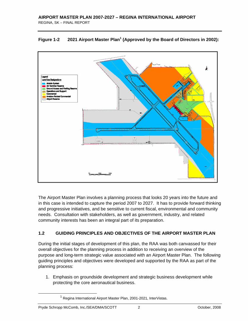
In the fall of 2007, the Regina Airport Authority (RAA) commissioned the consulting team of Pryde Schropp McComb, Inc., Saunders Evans Architects Inc, SCOTT Associates Architects, Inc, and Derek Murray Consulting and Associates to update the Airport Master Plan. The Airport Master Plan is intended to be a blueprint for future development of the Regina International Airport (YQR), which is managed and operated by the Regina Airport Authority (RAA). This plan is a description of the most appropriate development options regarding land use, facilities, and services required to ensure YQR meets its strategic objectives and accommodates expected levels of traffic over the next 20 years. It builds upon the previous Transport Canada 1998 Land Use Plan (Figure 1-1) and 2021 Master Plan (Figure 1-2) and is guided by the progressive efforts of the RAA since taking over the operation of the facility in 1999. The Airport Master Plan also serves to address the requirements of the Transport Canada Ground Lease Agreement which requires periodic reviews and updates to the Airport Master Plan at ten (10) year intervals.
Figure 1-1 1998 Transport Canada Land Use Plan (At time of Transfer)
AIRPORT MASTER PLAN 2007-2027 – REGINA INTERNATIONAL AIRPORT REGINA, SK – FINAL REPORT
Pryde Schropp McComb, Inc./SEA/DMA/SCOTT 2 October, 2008
Figure 1-2 2021 Airport Master Plan1 (Approved by the Board of Directors in 2002):
The Airport Master Plan involves a planning process that looks 20 years into the future and in this case is intended to capture the period 2007 to 2027. It has to provide forward thinking and progressive initiatives, and be sensitive to current fiscal, environmental and community needs. Consultation with stakeholders, as well as government, industry, and related community interests has been an integral part of its preparation.
1.2 GUIDING PRINCIPLES AND OBJECTIVES OF THE AIRPORT MASTER PLAN
During the initial stages of development of this plan, the RAA was both canvassed for their overall objectives for the planning process in addition to receiving an overview of the purpose and long-term strategic value associated with an Airport Master Plan. The following guiding principles and objectives were developed and supported by the RAA as part of the planning process:
1. Emphasis on groundside development and strategic business development while protecting the core aeronautical business.
1 Regina International Airport Master Plan, 2001-2021, InterVistas.
AIRPORT MASTER PLAN 2007-2027 – REGINA INTERNATIONAL AIRPORT REGINA, SK –FINAL REPORT
October, 2008 3 Pryde Schropp McComb, Inc./SEA/DMA/SCOTT
2. Ensure that future development does not conflict with the safe operation of the airport.
3. Reserve sufficient lands to allow for future expansion or redevelopment of operational facilities.
4. Designate airport lands for specific development functions.
5. Encourage compatible land uses on adjacent lands and municipalities.
6. Prepare an updated Long-term Airport Development Concept Plan and Land Use Plan.
7. Comply with the Transport Canada Ground Lease Requirements.
8. The Airport Master Plan is not:
• A prescribed schedule of development.
• An engineering and technical study.
• A commitment of funding.
• A project definition report.
9. The scope of an Airport Master Plan includes:
• Inventory of the existing facilities.
• Public and Stakeholder Consultations.
• Forecasts and Socio-Economic Position of the Airport.
• Testing the facilities against forecasts to confirm adequacy.
• Develop options for future improvements/expansions.
• Reserve sufficient lands for future expansions and development.
• Prepare an updated Long-term Airport Development Concept Plan and Land Use Plan.
1.3 AIRPORT ROLE AND ECONOMIC BENEFITS
Regina Airport is designated a National Airport System (NAS) airport under the National Airports Policy. NAS airports link Canada coast to coast as well as internationally, and are considered essential to Canada’s domestic prosperity and international competitiveness.
AIRPORT MASTER PLAN 2007-2027 – REGINA INTERNATIONAL AIRPORT REGINA, SK – FINAL REPORT
Pryde Schropp McComb, Inc./SEA/DMA/SCOTT 4 October, 2008
Regionally, the Airport provides residents of the provincial capital and communities in Saskatchewan with scheduled and charter services for passengers and cargo. Flights are available to many major Canadian airports and to Minneapolis in the United States, allowing connection to transcontinental and international routes. Services and support are provided for general aviation activities, which include other commercial operations (commercial flight training, sightseeing, aerial surveys and aerial inspection services, etc.), government aircraft services, and corporate/private aircraft operations. YQR also serves the needs of aircraft maintenance, hangar storage and fixed base operators.
The general role of the Regina Airport has not changed throughout the years; however, the activity levels have changed. For example, while passenger activity has progressively increased, local aircraft movements have declined significantly over the past twenty years.2
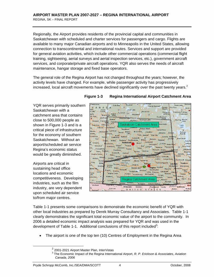
Figure 1-3 Regina International Airport Catchment Area
YQR serves primarily southern Saskatchewan with a catchment area that contains close to 500,000 people as shown in Figure 1-3 and is a critical piece of infrastructure for the economy of southern Saskatchewan. Without an airport/scheduled air service Regina’s economic status would be greatly diminished.
Airports are critical in sustaining head office locations and economic competitiveness. Developing industries, such as the film industry, are very dependent upon scheduled air service to/from major centres.
Table 1-1 presents some comparisons to demonstrate the economic benefit of YQR with other local industries as prepared by Derek Murray Consultancy and Associates. Table 1-1 clearly demonstrates the significant total economic value of the airport to the community. In 2006 a detailed economic impact analysis was prepared for YQR and was used in the development of Table 1-1. Additional conclusions of this report included3:
The airport is one of the top ten (10) Centres of Employment in the Regina Area
2 2001-2021 Airport Master Plan, InterVistas 3 The Economic Impact of the Regina International Airport, R. P. Erickson & Associates, Aviation
Canada, 2006
AIRPORT MASTER PLAN 2007-2027 – REGINA INTERNATIONAL AIRPORT REGINA, SK –FINAL REPORT
October, 2008 5 Pryde Schropp McComb, Inc./SEA/DMA/SCOTT
Each 1000 E&D4 passengers supports 5.8 full time jobs.
Each 1000 E&D passengers supports $160,000 of annual labour income.
Each 1000 E&D passengers supports $424,000 of total GDP5 activity.
Each time a B737 lands and takes off, it supports 1.50 FTE6s; $42,000 of annual labour income; and $110,000 of GDP activity.
Each time a Bombardier Regional Jet lands and takes off, it supports 0.87 FTEs; $24,000 of annual labour income; and $64,000 of GDP activity.
Table 1-1 Economic Stimulus Comparisons
YQR/RAA triggers an employment impact of 4,804 (FTEs) and $350 million in GDP(1)
NFTC Air Force Base creates 1,132 jobs (FTEs) in Saskatchewan and generates $52 million in GDP(2)
The Saskatchewan film industry has average annual production value of $45 million and employment of 651 full-time positions(3)
(1) Source: R. P. Erickson & Associates, Aviation Canada – Economic Impact of the Regina International Airport, 2006
(2) Source: An Economic Assessment of the Economic Benefits Resulting from Operations of the NATO Flying Training in Canada (NFTC) Program at Moose Jaw Saskatchewan, DMCA, November 2002.
(3) Source: Economic Impact Statement for the Province’s Film and Video Industry, DMCA, 2004.
1.4 REGINA AIRPORT AUTHORITY AND THE AIRPORT MASTER PLAN
The Regina Airport Authority Inc. (RAA) is a not-for-profit corporation which operates the Regina International Airport under a 60-year lease from Transport Canada. The Authority is 100% self-financing, and does not receive any public monies from any level of government. 7
The RAA is governed by a Board of Directors appointed from within the community. Members are appointed by:
4 E/D – Enplaned and Deplaned 5 GDP – Gross Domestic Product 6 FTE – Full time equivalent 7 www.yqr.ca
AIRPORT MASTER PLAN 2007-2027 – REGINA INTERNATIONAL AIRPORT REGINA, SK – FINAL REPORT
Pryde Schropp McComb, Inc./SEA/DMA/SCOTT 6 October, 2008
City of Regina
City of Moose Jaw
Rural Municipality of Sherwood
Regina Airport Authority Inc.
Government of Saskatchewan
Government of Canada
In 2002, the RAA set out the strategic direction and objectives for Regina International Airport. The Plan was developed through extensive consultation with the airport’s stakeholders, its management and the RAA Board of Directors. The Strategic Plan has provided important guidance for the implementation of the past Airport Master Plan. At the time the RAA adopted the following Mission Statement which is still supported today:
To operate a world class aviation facility in a safe, secure, efficient and commercially viable manner, in partnership with the community.
The RAA Airport Strategic Plan 2002 – 2006 remains the officially adopted plan by the RAA and its strategic goals have also influenced the direction and objectives of this Airport Master Plan as follows:
The Regina Airport Strategic Plan sets out the following strategic goals:
o Operate a safe, secure and environmentally responsible airport;
o Become a more effective regional gateway;
o Remain financially viable and cost competitive;
o Ensure facilities address current and future demands of users; and
o Maintain a talented and motivated team of professionals.
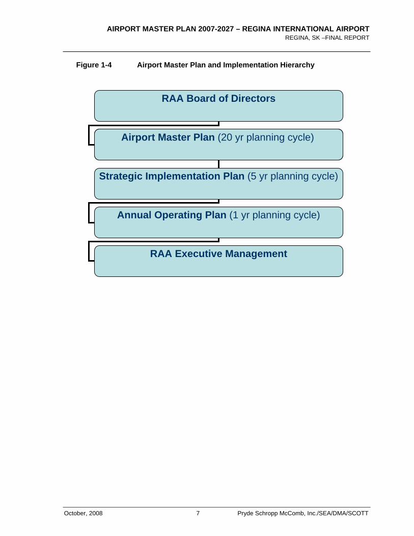
During the development of this Airport Master Plan, it became evident that there was a need to updated and refresh the RAA’s strategic goals. The following Figure 1-4 was developed to assist the RAA in understanding the role of the Airport Master Plan with respect to their future strategic planning initiatives. It is recommended that the RAA use this updated Airport Master Plan as a fundamental building block in developing their new strategic plan.
AIRPORT MASTER PLAN 2007-2027 – REGINA INTERNATIONAL AIRPORT REGINA, SK –FINAL REPORT
October, 2008 7 Pryde Schropp McComb, Inc./SEA/DMA/SCOTT
RAA Board of Directors
Airport Master Plan (20 yr planning cycle)
Strategic Implementation Plan (5 yr planning cycle)
Annual Operating Plan (1 yr planning cycle)
RAA Executive Management
Figure 1-4 Airport Master Plan and Implementation Hierarchy
AIRPORT MASTER PLAN 2007-2027 – REGINA INTERNATIONAL AIRPORT REGINA, SK – FINAL REPORT
Pryde Schropp McComb, Inc./SEA/DMA/SCOTT 8 October, 2008
1.5 PREVIOUS RELEVANT STUDIES
Since taking control of the Airport in 1999, the RAA has completed a number of planning studies to better understand the Airport’s potential and to establish a course for future opportunities that leverage the Airport’s services and role in the community. The most relevant of these studies are included in the list below and were used as a source of background information for this plan:
InterVistas Consulting Inc., 2001-2021 Airport Master Plan, August, 2002.
Pryde Schropp McComb Inc., 2005 Runway Configuration Options and Noise Abatement Regina International Airport & City Of Regina, October 2005.
R. P. Erickson & Associates, Aviation Canada – Economic Impact of the Regina International Airport, 2006
UMA Engineering, Draft Final Report, Regina Airport Authority, Traffic and Groundside Infrastructure Study, 2007
The RAA continues to act upon many of the recommendations of these studies with a recent emphasis on implementing improvements to the groundside parking facilities and the 2005 Air Terminal Building renovations, all focussed on improving the conditions for the traveling public. With a proactive approach to the governance of the Airport, the RAA has developed a very strong understanding of a development plan for the Airport with some very clear objectives.
Furthermore, in 2005 the RAA completed a detailed study entitled “2005 Runway Configuration Options and Noise Abatement Regina International Airport & City Of Regina”which projected the very long-term air traffic and aircraft noise environment at YQR. This study was triggered by the aggressive population growth within the City of Regina and the need for residential development lands to accommodate this growth. The study made the following recommendations, many of which have been implemented by the RAA and City:
1. It is recommended that the Airport and City adopt the 2024 NEP contours developed as part of this study.
2. Furthermore, that the 30 NEF be recognized as the limit within which no residential development should be permitted.
3. Finally, that the zone between 25-30 NEF of the 2024 NEP be recognized as AirportNoise Impact Buffer Zone and that consideration of no or limited residential development be observed and/or acoustical provisions be required for development in conjunction with noise covenants.
4. It is recommended that the Regina Airport Authority recognize the extension of Runway 13-31 to the northwest as outlined in Options 2 and 4 and amend their
AIRPORT MASTER PLAN 2007-2027 – REGINA INTERNATIONAL AIRPORT REGINA, SK –FINAL REPORT
October, 2008 9 Pryde Schropp McComb, Inc./SEA/DMA/SCOTT
Airport Master Plan and AOM to recognize this extension configuration. Appropriate budgets should be established for its potential future implementation.
5. It is recommended that the Airport Authority investigate amending its existing zoning regulations to include additional Bird Hazard and Aeronautical Facility protection clauses.
This report tested various airside facilities for capacity and expansion which have been re-confirmed in this Airport Master Plan.
1.6 SUMMARY OF KEY RECOMMENDATIONS
Based on the foregoing, the following key recommendations were developed:
1. It is recommended that following the approval by the Board of Directors of this 2007-2027 Airport Master Plan, that the RAA initiate a new Strategic Planning Session. This planning session would update the RAA’s short, medium and long-term strategic plans and objectives consistent with this new Airport Master Plan.

AIRPORT MASTER PLAN 2007-2027 – REGINA INTERNATIONAL AIRPORT REGINA, SK – FINAL REPORT
Pryde Schropp McComb, Inc./SEA/DMA/SCOTT 10 October, 2008
< THIS PAGE LEFT INTENTIONALLY BLANK >
AIRPORT MASTER PLAN 2007-2027 – REGINA INTERNATIONAL AIRPORT REGINA, SK –FINAL REPORT
October, 2008 11 Pryde Schropp McComb, Inc./SEA/DMA/SCOTT
2.0 Existing Airport Overview
2.1 GENERAL
The Regina Airport is located approximately four kilometres southwest of Regina’s city centre. Urban development bounds the site to the north, east and southeast. The Trans-Canada Highway is approximately 2.5 km south of the airport. The CPR mainline railway runs along the northern boundary of the site. The airport’s internal road network connects with adjacent urban roads to the east, notably to Lewvan Drive that runs north-south along the airport site’s eastern edge. Located on about 517 hectares of land southwest of the City of Regina, the YQR site is irregular in shape. The airfield configuration dominates the airport layout while the eastern quadrant of the site is the main airport development area as shown on Exhibit 1.8
The major airport components are:
Airfield – includes the runway and taxiway system, apron and aeronautical protection areas, as well as most of the Airport’s navigational aids.
Air Terminal Complex – includes the Air Terminal Building (ATB) and the adjacent aircraft apron to serve air carrier operations.
Groundside Access and Parking – includes the main Airport and terminal access, road circulation within the Airport and various parking facilities for passengers and employees.
Air Cargo Facilities – includes cargo facilities for carriers and couriers.
Commercial Services and Facilities – include aviation-related and support services/ facilities such as general and corporate aviation, fuel storage, and various aircraft hangers. Also included are specialized and other commercial facilities such as car rental depots.
Airport Operations and Support Facilities – include Airport administration and maintenance, emergency response service as well as utilities and services.
2.2 HISTORY
The current site of YQR has its historical beginnings in early as 1919, with the opening of the first airfield in the region. In 1927, a second airfield, known as Lakeview Aerodrome, began serving the region. The Regina Flying Club was formed in 1927 and it later purchased 160 acres of land for the development of Regina’s third airport site. In 1928, the city of Regina bought land from the club and a start was made on the development of the present Regina
8 2001-2021 Airport Master Plan, 2002
AIRPORT MASTER PLAN 2007-2027 – REGINA INTERNATIONAL AIRPORT REGINA, SK – FINAL REPORT
Pryde Schropp McComb, Inc./SEA/DMA/SCOTT 12 October, 2008
Airport, a few kilometres west of the city. The official opening of the Regina Airport was held in September 1930.
With the outbreak of World War II, Regina Airport was taken over by Transport Canada who retained ownership until 1955, when the City of Regina resumed operation of the airport. However, due to financial difficulties, Transport Canada bought the airport from the city and assumed responsibility for its operation on January 1, 1972. In November 1998, the Regina Airport Authority and Transport Canada reached an agreement for the transfer of Regina Airport. On May 1, 1999, the Regina Airport Authority accepted responsibility for the management of the airport.9
2.3 AIRPORT OVERVIEW
Regina International Airport is operational 24 hours a day, 7 days a week, for day and night VFR and IFR traffic. It is equipped to handle Category I precision approaches and departures in visibilities down to ½ mile. The airport is certified to Transport Canada standards and consists of the following primary facilities which are also highlighted in Exhibit 1:
• Regina’s airfield has two intersecting runways.
• Runway 13-31 is the primary runway, 7,900 feet long, and served by a full-length parallel taxiway with five exits. Runway 13 is certified to 4C precision standards and equipped with a Category I Instrument Landing System together with high intensity approach lighting to facilitate low visibility operations. The runway has a Pavement Load Rating (PLR) of 11 and was rehabilitated in 1992.
• Runway 08-26 is a secondary runway, 6,200 feet long and certified to 4C non-precision standards. It does not have a parallel taxiway; a taxiway exit occurs at approximately the runway mid-point. No taxiway serves the west half of the runway, requiring aircraft to taxi on the runway. The runway has a PLR of 11 and condition varies from good to very good.
• The taxiway system at YQR is made up of eight designated taxiways, A, B, B1, C, K, M, N and P.
• There are four designated areas covering apron surfaces at Regina, Aprons I through IV. Apron I supports air carrier operations from the ATB while Apron II is used for courier activity, VIP visits and itinerant parking. Apron III accommodates commercial hangar operations and G.A. activity while Apron IV is an asphalt surface used mainly for long-term aircraft parking and was reduced in size in 2007 due to limited use and operational surface rationalization by the RAA.
9 2001-2021, Airport Master Plan, 2002
AIRPORT MASTER PLAN 2007-2027 – REGINA INTERNATIONAL AIRPORT REGINA, SK –FINAL REPORT
October, 2008 13 Pryde Schropp McComb, Inc./SEA/DMA/SCOTT
• Systematic rehabilitation of the facilities has taken place and continues to be planned in accordance with an overall capital plan.
• RAA has supported and initiated the rationalization of various airside facilities in the interest of operational efficiency without a reduction in the level of services and future expandability. (e.g. reduction of runway widths from 60m to 45m by Transport Canada and recent Apron IV size reduction by RAA)
• ILS Navigational Aids may be upgraded by NAV CANADA in short to medium term (Glide Path and Localizer for Runway 13-31).
• An Air Terminal Building which was expanded in 2005.
• Full complement of support and operational services.
• Commercial development areas promote non-aviation revenues. Refer to Appendix A for a current commercial tenant inventory.
2.4 AERONAUTICAL ZONING
Airport facilities require special protection measures given the very unique operating environment for aircraft and associated electronic instrumentation. The following sections provide an overview of the primary protection areas associated with the Regina International Airport.
Airport Obstacle Limitation Surfaces
Obstacle Limitation Surfaces are established around an Airport to ensure a satisfactory level of safety. These surfaces normally extend well beyond the boundary of the Airport and therefore require protection by the enactment of Zoning Regulations or Legal Instruments which will prohibit the erection of structures which would violate any of the defined plane surfaces.
AIRPORT MASTER PLAN 2007-2027 – REGINA INTERNATIONAL AIRPORT REGINA, SK – FINAL REPORT
Pryde Schropp McComb, Inc./SEA/DMA/SCOTT 14 October, 2008
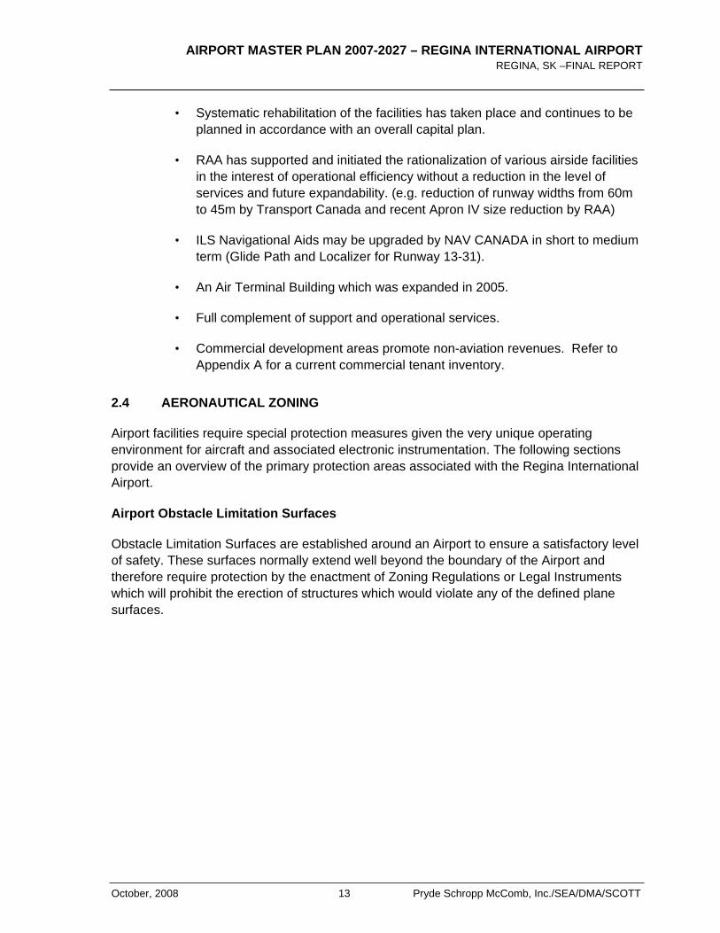
These surfaces are shown in the diagram below and are described as follows:
Outer Surface
An outer surface shall be established where required for the protection of aircraft conducting a circling procedure or manoeuvring in the vicinity of an aerodrome.
Takeoff/ApproachAreas and Surfaces
They are established for each runway direction intended to be used for the takeoff and landing of aircraft.
Transitional Surface Source: TP1247
Transitional surface is a complex surface along the sides of the runway strip and part of the approach surface that slopes up to the outer surface. Its purpose is to ensure the safety of aircraft at low altitudes displaced from the runway centre line in the approach or missed approach phase.
Buildings, structures or natural growth protruding the Obstacle Limitation Surfaces are prohibited. The maximum height of any structure is governed by its proximity to the runways, taxiways and any electronic or navigational-aid equipment.
All Airport development falling within the affected zones are also subject to these restrictions and guidelines to remain in compliance with the Airport’s operating certificate.
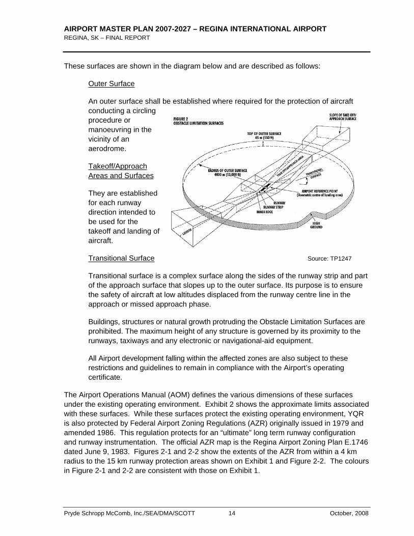
The Airport Operations Manual (AOM) defines the various dimensions of these surfaces under the existing operating environment. Exhibit 2 shows the approximate limits associated with these surfaces. While these surfaces protect the existing operating environment, YQR is also protected by Federal Airport Zoning Regulations (AZR) originally issued in 1979 and amended 1986. This regulation protects for an “ultimate” long term runway configuration and runway instrumentation. The official AZR map is the Regina Airport Zoning Plan E.1746 dated June 9, 1983. Figures 2-1 and 2-2 show the extents of the AZR from within a 4 km radius to the 15 km runway protection areas shown on Exhibit 1 and Figure 2-2. The colours in Figure 2-1 and 2-2 are consistent with those on Exhibit 1.
AIRPORT MASTER PLAN 2007-2027 – REGINA INTERNATIONAL AIRPORT REGINA, SK –FINAL REPORT
October, 2008 15 Pryde Schropp McComb, Inc./SEA/DMA/SCOTT
The existing AZR is based on imperial dimensions and does not comply with current Transport Canada TP312 metric airport design standards. However, the differences between current standards and those included in the AZR are not significant and there is a low risk to the future protection of the airport.
The AZR protects the airport as follows:
• The AZR protects all runways for precision (ILS) approaches although not all runways currently operate under precision standards.
• The AZR protects for object heights and bird attraction land use incompatibilities.
• The AZR does not include electronic zoning (Navigational and Communication Aids).
It should be noted that the AZR is annotated on the Land Title of each affected parcel of land. As such, individual land owners are responsible to comply with the requirements of the AZR. While the onus is on the landowner to comply, the RAA continues to be proactive and performs aeronautical compatibility reviews of land use proposals in cooperation with the local municipalities. This approach assists the overall process by reducing the risk of non-compliant proposals well before construction actually begins. This process has worked well in the past and continues today.
Upon review of the existing AZR documentation as part of the master planning process, it became evident that the AZR boundary crosses over the existing Courtney Street right-of-way on the west side of the airport. This conflict is discussed further in Section 13.3.

AIRPORT MASTER PLAN 2007-2027 – REGINA INTERNATIONAL AIRPORT REGINA, SK – FINAL REPORT
Pryde Schropp McComb, Inc./SEA/DMA/SCOTT 16 October, 2008
Figure 2-1 Federal Airport Zoning Regulations (AZR) – 4 km Radius
Source: Transport Canada
Approximately 4 kms (Outer
Surface)
AIRPORT MASTER PLAN 2007-2027 – REGINA INTERNATIONAL AIRPORT REGINA, SK –FINAL REPORT
October, 2008 17 Pryde Schropp McComb, Inc./SEA/DMA/SCOTT
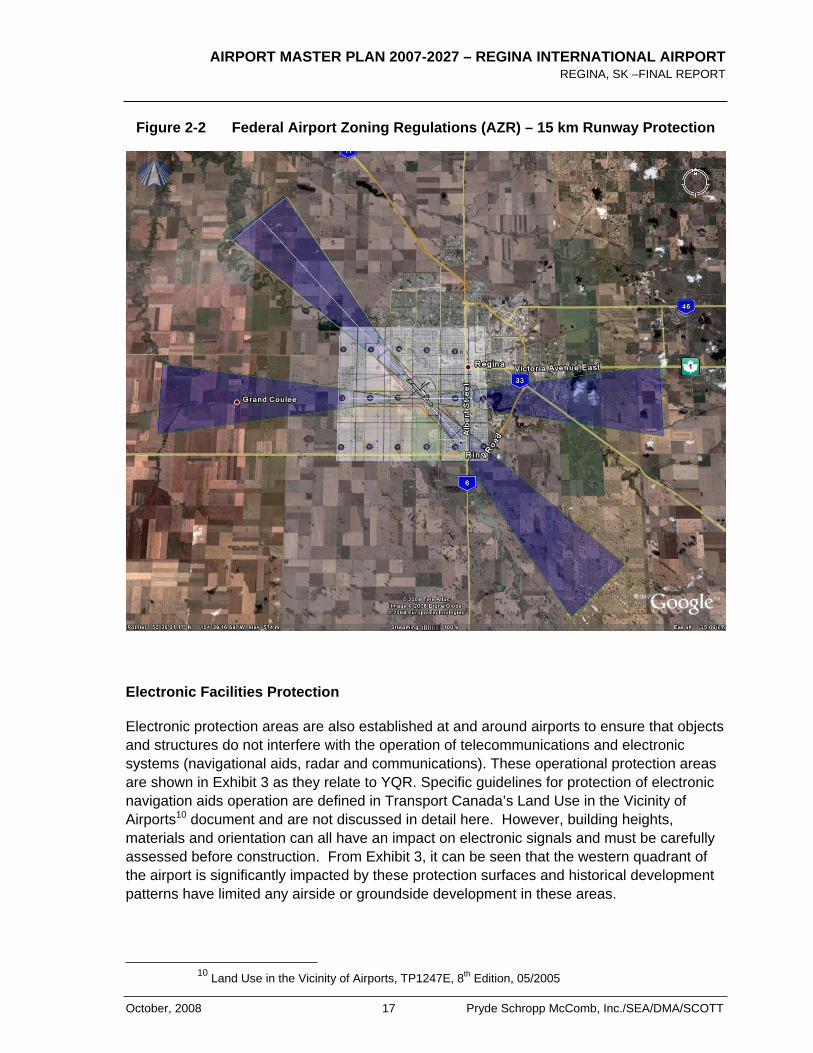
Figure 2-2 Federal Airport Zoning Regulations (AZR) – 15 km Runway Protection
Electronic Facilities Protection
Electronic protection areas are also established at and around airports to ensure that objects and structures do not interfere with the operation of telecommunications and electronic systems (navigational aids, radar and communications). These operational protection areas are shown in Exhibit 3 as they relate to YQR. Specific guidelines for protection of electronic navigation aids operation are defined in Transport Canada’s Land Use in the Vicinity of Airports10 document and are not discussed in detail here. However, building heights, materials and orientation can all have an impact on electronic signals and must be carefully assessed before construction. From Exhibit 3, it can be seen that the western quadrant of the airport is significantly impacted by these protection surfaces and historical development patterns have limited any airside or groundside development in these areas.
10 Land Use in the Vicinity of Airports, TP1247E, 8th Edition, 05/2005
AIRPORT MASTER PLAN 2007-2027 – REGINA INTERNATIONAL AIRPORT REGINA, SK – FINAL REPORT
Pryde Schropp McComb, Inc./SEA/DMA/SCOTT 18 October, 2008
NAV CANADA is the agency responsible for the air navigation system in Canada and supports the use of these protection areas for managing land use and protection of their infrastructure at YQR.
As noted above, the Federal Airport Zoning Regulations currently in effect at YQR do not include any means to enforce protection for these electronic instruments. Within the boundaries of the airport, however, the RAA has control of land use and has an obligation to ensure no impacts on the NAV CANADA facilities. Off-site, RAA or NAV CANADA have no authority and must rely on the cooperation of the surrounding land owners and municipalities. The RAA’s community involvement initiatives have assisted in this process and will continue to play a major role in mitigating any potential conflicts. The RAA is aware that there are currently no federal regulations in place to protect these facilities. Many other airports in Canada have similar short-comings and are now investigating the costs and technical merits to amend the existing regulation to include electronic protection. Should an opportunity arise to amend the existing YQR AZR in the future in a cost effective manner, it is recommended that the RAA do so.
2.5 AIRPORT INTERFACE WITH THE COMMUNITY
Since the RAA operates under federal jurisdiction, the Ground Lease Agreement suggests that Airport Authorities enter into a dialogue with the host municipality to encourage a mutually agreeable understanding of how the airport will fit within the planning framework of the municipality. The RAA has and continues to foster a mutually agreeable understanding with the City of Regina and Rural Municipality (RM) of Sherwood on development within the airport boundaries. Exhibit 4 shows the airport with respect to the surrounding municipal land use plans for both municipalities.
City of Regina
The airport is located within the limits of the City of Regina. The City’s Zoning Bylaw recognizes the airport but also acknowledges that the bylaw has no authority over land use on the airport lands. Appendix E contains an excerpt from the zoning bylaw confirming the above.
The City and RAA have had a cooperative relationship and the City has recognized the importance of the airport in a number of recent planning initiatives as follows:
Southwest Sector Plan – The City has carefully planned light Industrial buffers between airport and residential land uses. Furthermore, the City has supported and adopted the official 2024 NEF Contour as developed in close consultation with the RAA in 2005. Exhibit 5 shows the airport, the 2024 NEF contours in context of the City’s Southwest Sector Planning Concept. The City also adopted the 30 NEF as the official contour above which residential development should not be permitted consistent with Transport Canada recommendations.
The City’s 2007 Industrial Growth Plan recognizes the value or the airport as part of a strategic transportation network to support light industrial initiatives north and
AIRPORT MASTER PLAN 2007-2027 – REGINA INTERNATIONAL AIRPORT REGINA, SK –FINAL REPORT
October, 2008 19 Pryde Schropp McComb, Inc./SEA/DMA/SCOTT
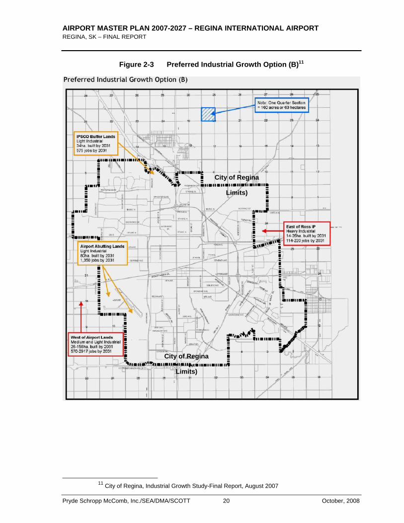
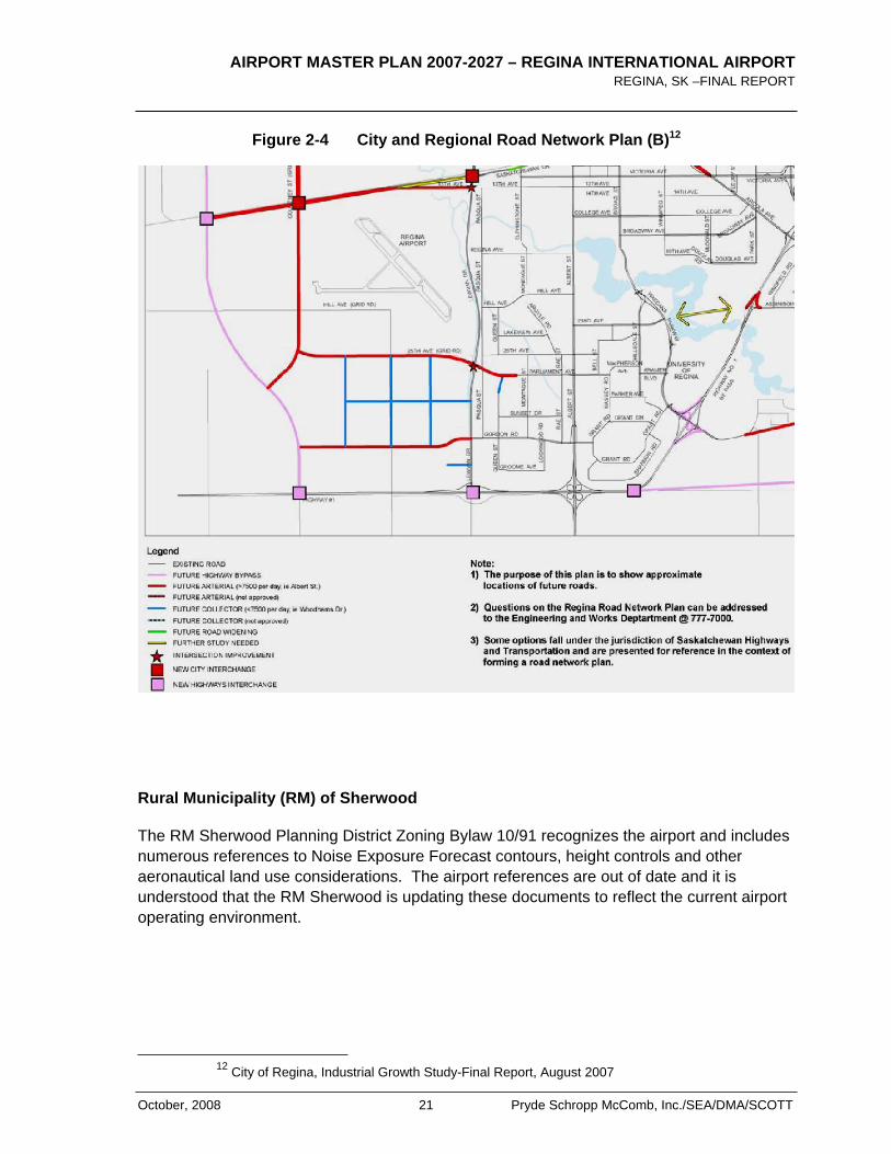
west of the airport. Figure 2-3 shows the preferred option in relation to the airport. Figure 2-4 also presents the long-term road network strategy for this plan and how it relates to the airport and the industrial growth strategy.
The recommended industrial growth option is summarized below based on the final report prepared by Metropolitan Knowledge International, in association with UMA, Meridian Planning Consultants, and the Centre for Spatial Economics. It is important to note that airport plays an integral part of the overall plan.
“…This option includes four industrial growth areas:
Lands designated industrial adjacent to the Airport, per the Southwest Sector Plan.
The IPSCO Buffer Lands, north of Argyle Park/Kensington Greens
An expansion of Ross Industrial Park to the east, outside the City’s boundaries
Lands west of the Airport, outside the City’s boundaries.
This option is preferable for several reasons. Development of light industrial uses adjacent to the Airport is desirable, as warehouse and distribution facilities and other “clean”, light industrial uses are a compatible form of development near an airport. This location also provides good connections to rail, air, and road transportation facilities, and best supports the economic development objectives of the Regina Regional Economic Development Authority. Similarly, light industrial uses in the IPSCO buffer lands provides a logical buffer between residential and commercial uses in the Rochdale Boulevard Area and IPSCO to the north. By also providing for an additional expansion of the Ross Industrial Park, the option also ensures continued availability of lands for firms that wish to expand in this area, and maintains available lands on the east side for access to Highway 1 and rail infrastructure in this area. It also provides for a potential location for heavier industry in this area.
From an infrastructure point of view, Option B has the additional advantage of providing more flexibility in terms of when servicing is provided, such that growth can take place on lands east of Ross at the same time as development of the lands west of the airport, allowing for the timing of major potential infrastructure projects to be spread out. This flexibility also provides greater choice to the market, in terms of offering multiple potential locations…”
AIRPORT MASTER PLAN 2007-2027 – REGINA INTERNATIONAL AIRPORT REGINA, SK – FINAL REPORT
Pryde Schropp McComb, Inc./SEA/DMA/SCOTT 20 October, 2008
Figure 2-3 Preferred Industrial Growth Option (B)11
11 City of Regina, Industrial Growth Study-Final Report, August 2007
City of Regina
Limits)
City of Regina
Limits)
AIRPORT MASTER PLAN 2007-2027 – REGINA INTERNATIONAL AIRPORT REGINA, SK –FINAL REPORT
October, 2008 21 Pryde Schropp McComb, Inc./SEA/DMA/SCOTT
Figure 2-4 City and Regional Road Network Plan (B)12
Rural Municipality (RM) of Sherwood
The RM Sherwood Planning District Zoning Bylaw 10/91 recognizes the airport and includes numerous references to Noise Exposure Forecast contours, height controls and other aeronautical land use considerations. The airport references are out of date and it is understood that the RM Sherwood is updating these documents to reflect the current airport operating environment.
12 City of Regina, Industrial Growth Study-Final Report, August 2007
AIRPORT MASTER PLAN 2007-2027 – REGINA INTERNATIONAL AIRPORT REGINA, SK – FINAL REPORT
Pryde Schropp McComb, Inc./SEA/DMA/SCOTT 22 October, 2008
2.6 RAA COMMUNITY INTERFACE INITIATIVES
The RAA also actively engages the community and its Users through a number mechanisms including:
Airline Consultative Committee (ACC)
The purpose of the ACC is to consolidate airline views and provide an on-site channel for consultation with the Regina Airport Authority with respect to construction projects and capital projects, which may impact rental rates of, affected airline operations. Meetings are held quarterly, or at the request of any representative.
Community Consultation Committee (CCC)
The purpose of the Community Consultation Committee is to provide liaison between the community and the Authority’s Board of Directors through Authority Management, in Airport matters and general Airport policies that affect the community including; to learn and comment about Airport activities and plans; to discuss operations and future planning; and to share with the Authority local and municipal concerns.
Noise Abatement Procedures:
Cognizant of the impact of aircraft noise on the local community, the RAA has instituted Noise Abatement Procedures (NAP) at YQR to promote the use of less noise sensitive airways over the community. The published procedures are enforceable by Transport Canada and are included in applicable aeronautical publications.

AIRPORT MASTER PLAN 2007-2027 – REGINA INTERNATIONAL AIRPORT REGINA, SK –FINAL REPORT
October, 2008 23 Pryde Schropp McComb, Inc./SEA/DMA/SCOTT
3.0 Socio-Economic Environment, Aviation Activity and Forecasts
3.1 SOCIO-ECONOMIC ENVIRONMENT
Background
Regina is located in South-East part of Saskatchewan. The City is the Provincial Capital and centre of government services and activities. While the economy relies on agriculture and natural resources, Regina’s economy is mainly service-driven and diversifying. It is a centre for finance, insurance, real estate, transportation, trade and communications for the Region. Figure 3-1 shows the regional situation of the City of Regina.
Figure 3-1 City of Regina Regional Situation
AIRPORT MASTER PLAN 2007-2027 – REGINA INTERNATIONAL AIRPORT REGINA, SK – FINAL REPORT
Pryde Schropp McComb, Inc./SEA/DMA/SCOTT 24 October, 2008
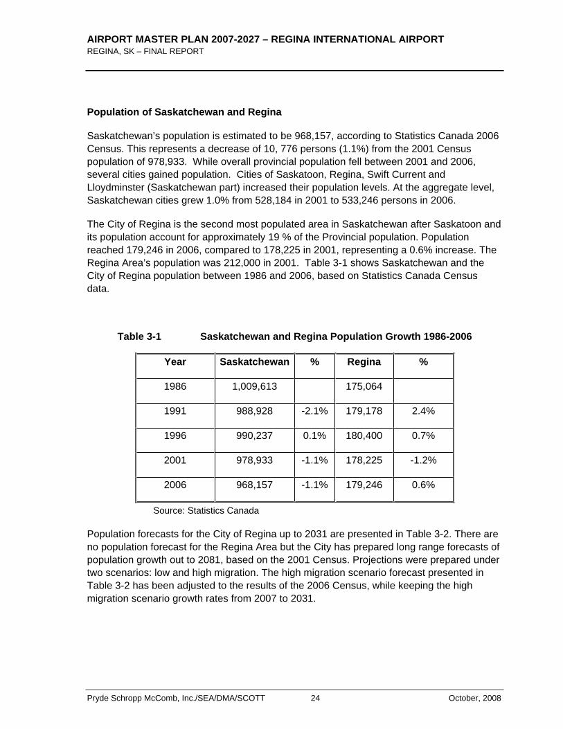
Population of Saskatchewan and Regina
Saskatchewan’s population is estimated to be 968,157, according to Statistics Canada 2006 Census. This represents a decrease of 10, 776 persons (1.1%) from the 2001 Census population of 978,933. While overall provincial population fell between 2001 and 2006, several cities gained population. Cities of Saskatoon, Regina, Swift Current and Lloydminster (Saskatchewan part) increased their population levels. At the aggregate level, Saskatchewan cities grew 1.0% from 528,184 in 2001 to 533,246 persons in 2006.
The City of Regina is the second most populated area in Saskatchewan after Saskatoon and its population account for approximately 19 % of the Provincial population. Population reached 179,246 in 2006, compared to 178,225 in 2001, representing a 0.6% increase. The Regina Area’s population was 212,000 in 2001. Table 3-1 shows Saskatchewan and the City of Regina population between 1986 and 2006, based on Statistics Canada Census data.
Table 3-1 Saskatchewan and Regina Population Growth 1986-2006
Year Saskatchewan % Regina %
1986 1,009,613 175,064
1991 988,928 -2.1% 179,178 2.4%
1996 990,237 0.1% 180,400 0.7%
2001 978,933 -1.1% 178,225 -1.2%
2006 968,157 -1.1% 179,246 0.6%
Source: Statistics Canada
Population forecasts for the City of Regina up to 2031 are presented in Table 3-2. There are no population forecast for the Regina Area but the City has prepared long range forecasts of population growth out to 2081, based on the 2001 Census. Projections were prepared under two scenarios: low and high migration. The high migration scenario forecast presented in Table 3-2 has been adjusted to the results of the 2006 Census, while keeping the high migration scenario growth rates from 2007 to 2031.

AIRPORT MASTER PLAN 2007-2027 – REGINA INTERNATIONAL AIRPORT REGINA, SK –FINAL REPORT
October, 2008 25 Pryde Schropp McComb, Inc./SEA/DMA/SCOTT
Table 3-2 Regina Projected Population 2007 to 2031
Year Population Annual Growth rate
2007 180,300 0.57% 2008 181,300 0.57% 2009 182,300 0.57% 2010 183,400 0.57% 2011 184,500 0.57% 2016 189,600 0.54% 2021 193,200 0.38% 2026 196,900 0.38% 2031 200,700 0.38%
Source: calculation of consultant based on 2006 Census and City of Regina long term forecast
The Conference Board of Canada forecasts that the population will continue to grow at a rate of 0.5% over the next five years, which is consistent with the projected population above.
Saskatchewan and Regina Economic Environment and Outlook
Regina's economic structure can be described in six high-level clusters, they are: Steel and Manufacturing; Information Technology; Film & Interactive Media; Environment; Finance & Insurance; Energy and Agri-Business. The City has a resourced-based economy fuelled by agriculture, mining, oil & gas, and telecommunications.
Regina's Gross Domestic Product (GDP) reached an estimated $6.1 billion dollars, an increase of 2.3% over the previous year and 16.6% over the last five years. In comparison to other Canadian cities such as Toronto, Winnipeg, Calgary, and Vancouver, Regina's growth in GDP is 1.6% above average in the last six years.
The Regina Regional Economic Development Authority (RRDEA) provides valuable information gathered from the Conference Board of Canada on the economic conditions and outlook for both Saskatchewan and Regina.
Employment
Employment in the Regina region has increased significantly for the first time in over 2 years. With an average real GDP growth rate of 2.2%, this increased job creation is expected to continue and improve the area’s labour market conditions.
AIRPORT MASTER PLAN 2007-2027 – REGINA INTERNATIONAL AIRPORT REGINA, SK – FINAL REPORT
Pryde Schropp McComb, Inc./SEA/DMA/SCOTT 26 October, 2008
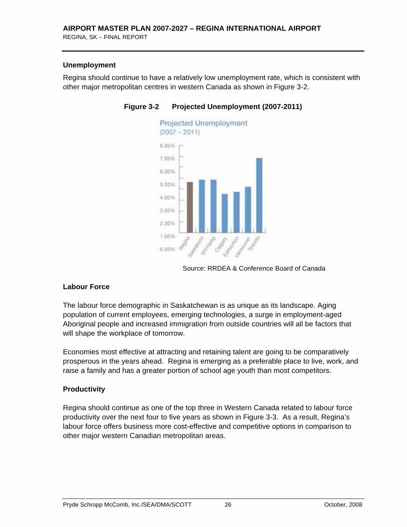
Unemployment Regina should continue to have a relatively low unemployment rate, which is consistent with other major metropolitan centres in western Canada as shown in Figure 3-2.
Figure 3-2 Projected Unemployment (2007-2011)
Source: RRDEA & Conference Board of Canada
Labour Force
The labour force demographic in Saskatchewan is as unique as its landscape. Aging population of current employees, emerging technologies, a surge in employment-aged Aboriginal people and increased immigration from outside countries will all be factors that will shape the workplace of tomorrow.
Economies most effective at attracting and retaining talent are going to be comparatively prosperous in the years ahead. Regina is emerging as a preferable place to live, work, and raise a family and has a greater portion of school age youth than most competitors.
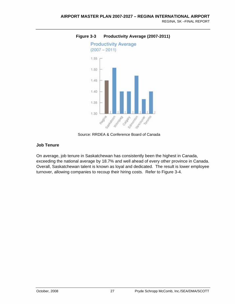
Productivity
Regina should continue as one of the top three in Western Canada related to labour force productivity over the next four to five years as shown in Figure 3-3. As a result, Regina’s labour force offers business more cost-effective and competitive options in comparison to other major western Canadian metropolitan areas.
AIRPORT MASTER PLAN 2007-2027 – REGINA INTERNATIONAL AIRPORT REGINA, SK –FINAL REPORT
October, 2008 27 Pryde Schropp McComb, Inc./SEA/DMA/SCOTT
Figure 3-3 Productivity Average (2007-2011)
Source: RRDEA & Conference Board of Canada
Job Tenure
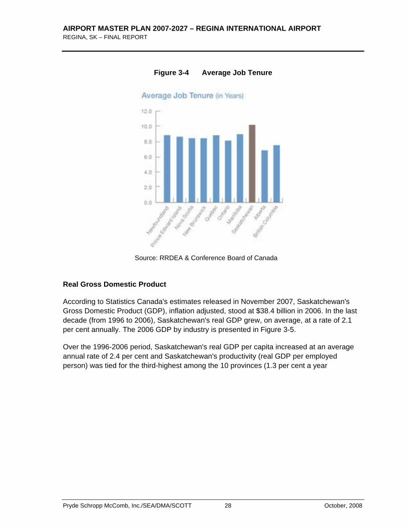
On average, job tenure in Saskatchewan has consistently been the highest in Canada, exceeding the national average by 18.7% and well ahead of every other province in Canada. Overall, Saskatchewan talent is known as loyal and dedicated. The result is lower employee turnover, allowing companies to recoup their hiring costs. Refer to Figure 3-4.
AIRPORT MASTER PLAN 2007-2027 – REGINA INTERNATIONAL AIRPORT REGINA, SK – FINAL REPORT
Pryde Schropp McComb, Inc./SEA/DMA/SCOTT 28 October, 2008
Figure 3-4 Average Job Tenure
Source: RRDEA & Conference Board of Canada
Real Gross Domestic Product
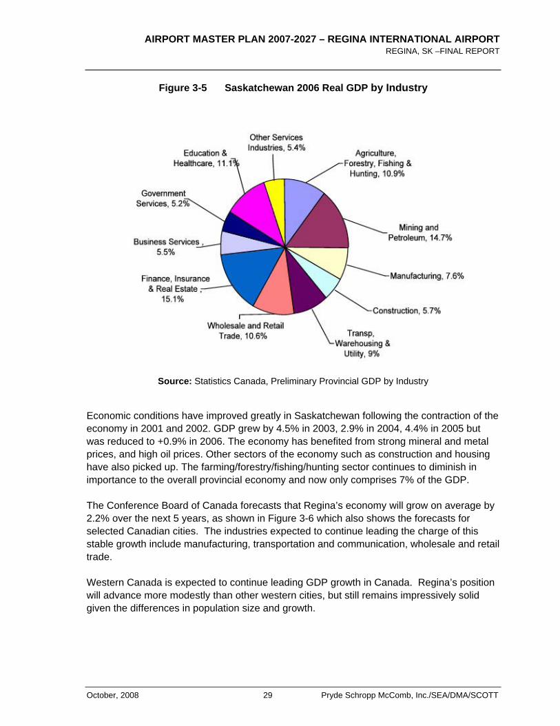
According to Statistics Canada's estimates released in November 2007, Saskatchewan's Gross Domestic Product (GDP), inflation adjusted, stood at $38.4 billion in 2006. In the last decade (from 1996 to 2006), Saskatchewan's real GDP grew, on average, at a rate of 2.1 per cent annually. The 2006 GDP by industry is presented in Figure 3-5.
Over the 1996-2006 period, Saskatchewan's real GDP per capita increased at an average annual rate of 2.4 per cent and Saskatchewan's productivity (real GDP per employed person) was tied for the third-highest among the 10 provinces (1.3 per cent a year
AIRPORT MASTER PLAN 2007-2027 – REGINA INTERNATIONAL AIRPORT REGINA, SK –FINAL REPORT
October, 2008 29 Pryde Schropp McComb, Inc./SEA/DMA/SCOTT
Figure 3-5 Saskatchewan 2006 Real GDP by Industry
Source: Statistics Canada, Preliminary Provincial GDP by Industry
Economic conditions have improved greatly in Saskatchewan following the contraction of the economy in 2001 and 2002. GDP grew by 4.5% in 2003, 2.9% in 2004, 4.4% in 2005 but was reduced to +0.9% in 2006. The economy has benefited from strong mineral and metal prices, and high oil prices. Other sectors of the economy such as construction and housing have also picked up. The farming/forestry/fishing/hunting sector continues to diminish in importance to the overall provincial economy and now only comprises 7% of the GDP.
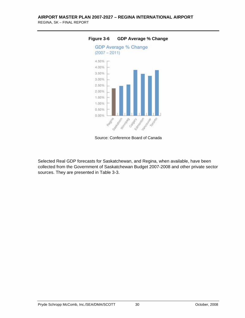
The Conference Board of Canada forecasts that Regina’s economy will grow on average by 2.2% over the next 5 years, as shown in Figure 3-6 which also shows the forecasts for selected Canadian cities. The industries expected to continue leading the charge of this stable growth include manufacturing, transportation and communication, wholesale and retail trade.
Western Canada is expected to continue leading GDP growth in Canada. Regina’s position will advance more modestly than other western cities, but still remains impressively solid given the differences in population size and growth.
AIRPORT MASTER PLAN 2007-2027 – REGINA INTERNATIONAL AIRPORT REGINA, SK – FINAL REPORT
Pryde Schropp McComb, Inc./SEA/DMA/SCOTT 30 October, 2008
Figure 3-6 GDP Average % Change
Source: Conference Board of Canada
Selected Real GDP forecasts for Saskatchewan, and Regina, when available, have been collected from the Government of Saskatchewan Budget 2007-2008 and other private sector sources. They are presented in Table 3-3.

AIRPORT MASTER PLAN 2007-2027 – REGINA INTERNATIONAL AIRPORT REGINA, SK –FINAL REPORT
October, 2008 31 Pryde Schropp McComb, Inc./SEA/DMA/SCOTT
Table 3-3 Real GDP Growth Forecast 2007-2011
Region Canada Canada Canada Saskatchewan Saskatchewan Regina
Source Bank of Canada
Conference Board of Canada
RBC RBC Government Budget 2007-2008
Conference Board of Canada
2006 2.8% 2.8% 0.4% 2.2%
2007 2.2% 2.8% 2.7% 4.8% 2.9% 2.2%
2008 1.7% 2.5% 4.3% 2.6% 2.2%
2009 2.8% 2.6% 3.2% 2.4% 2.2%
2010 2.2%
2011 2.2%
By comparison, the average annual growth rate of real GDP for Canada and Saskatchewan for the period 2001-2006 reached respectively 2.8 % and 2.5%, while their respective average annual growth rate was 2.8% for Canada and 2.6% for Saskatchewan between 2004 and 2006.
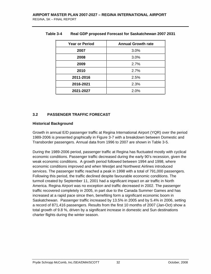
According to these forecasts, the real GDP growth for Saskatchewan should be slightly higher than Canada’s expected growth until 2009 or 2010. Table 3-4 shows our proposed long term GDP forecast for Saskatchewan. It is expected that the real GDP will continue to grow at 3.0% for 2007 and 2008, assuming high prices for potash and oil continue. From 2009 to 2027, the Real GDP should grow at a slower rate, ranging form 2.7 % in 2009 to 2.0% in 2021.
AIRPORT MASTER PLAN 2007-2027 – REGINA INTERNATIONAL AIRPORT REGINA, SK – FINAL REPORT
Pryde Schropp McComb, Inc./SEA/DMA/SCOTT 32 October, 2008
Table 3-4 Real GDP proposed Forecast for Saskatchewan 2007 2031
Year or Period Annual Growth rate
2007 3.0%
2008 3.0%
2009 2.7%
2010 2.7%
2011-2016 2.5%
2016-2021 2.3%
2021-2027 2.0%
3.2 PASSENGER TRAFFIC FORECAST
Historical Background
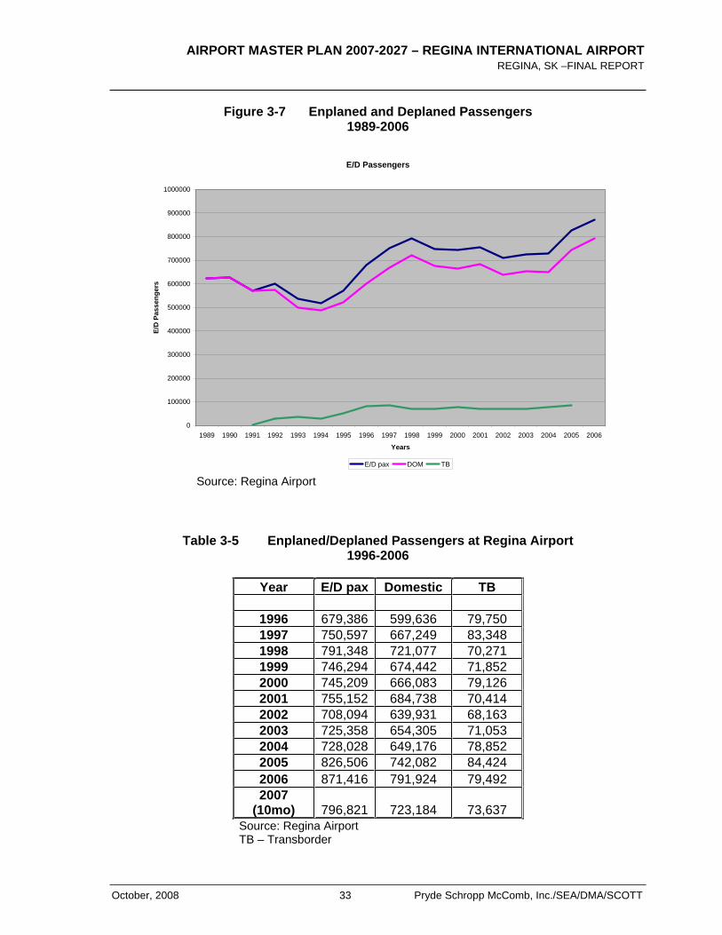
Growth in annual E/D passenger traffic at Regina International Airport (YQR) over the period 1989-2006 is presented graphically in Figure 3-7 with a breakdown between Domestic and Transborder passengers. Annual data from 1996 to 2007 are shown in Table 3-5.
During the 1989-2006 period, passenger traffic at Regina has fluctuated mostly with cyclical economic conditions. Passenger traffic decreased during the early 90’s recession, given the weak economic conditions. A growth period followed between 1994 and 1998, where economic conditions improved and when Westjet and Northwest Airlines introduced services. The passenger traffic reached a peak in 1998 with a total of 791,000 passengers. Following this period, the traffic declined despite favourable economic conditions. The turmoil created by September 11, 2001 had a significant impact on air traffic in North America. Regina Airport was no exception and traffic decreased in 2002. The passenger traffic recovered completely in 2005, in part due to the Canada Summer Games and has increased at a rapid pace since then, benefiting form a significant economic boom in Saskatchewan. Passenger traffic increased by 13.5% in 2005 and by 5.4% in 2006, setting a record of 871,416 passengers. Results from the first 10 months of 2007 (Jan-Oct) show a total growth of 9.8 %, driven by a significant increase in domestic and Sun destinations charter flights during the winter season.
AIRPORT MASTER PLAN 2007-2027 – REGINA INTERNATIONAL AIRPORT REGINA, SK –FINAL REPORT
October, 2008 33 Pryde Schropp McComb, Inc./SEA/DMA/SCOTT
Figure 3-7 Enplaned and Deplaned Passengers 1989-2006
E/D Passengers
0
100000
200000
300000
400000
500000
600000
700000
800000
900000
1000000
1989 1990 1991 1992 1993 1994 1995 1996 1997 1998 1999 2000 2001 2002 2003 2004 2005 2006
Years
E/D
Pas
seng
ers
E/D pax DOM TB
Source: Regina Airport
Table 3-5 Enplaned/Deplaned Passengers at Regina Airport 1996-2006
Year E/D pax Domestic TB
1996 679,386 599,636 79,750 1997 750,597 667,249 83,348 1998 791,348 721,077 70,271 1999 746,294 674,442 71,852 2000 745,209 666,083 79,126 2001 755,152 684,738 70,414 2002 708,094 639,931 68,163 2003 725,358 654,305 71,053 2004 728,028 649,176 78,852 2005 826,506 742,082 84,424 2006 871,416 791,924 79,492 2007
(10mo) 796,821 723,184 73,637 Source: Regina Airport
TB – Transborder
AIRPORT MASTER PLAN 2007-2027 – REGINA INTERNATIONAL AIRPORT REGINA, SK – FINAL REPORT
Pryde Schropp McComb, Inc./SEA/DMA/SCOTT 34 October, 2008
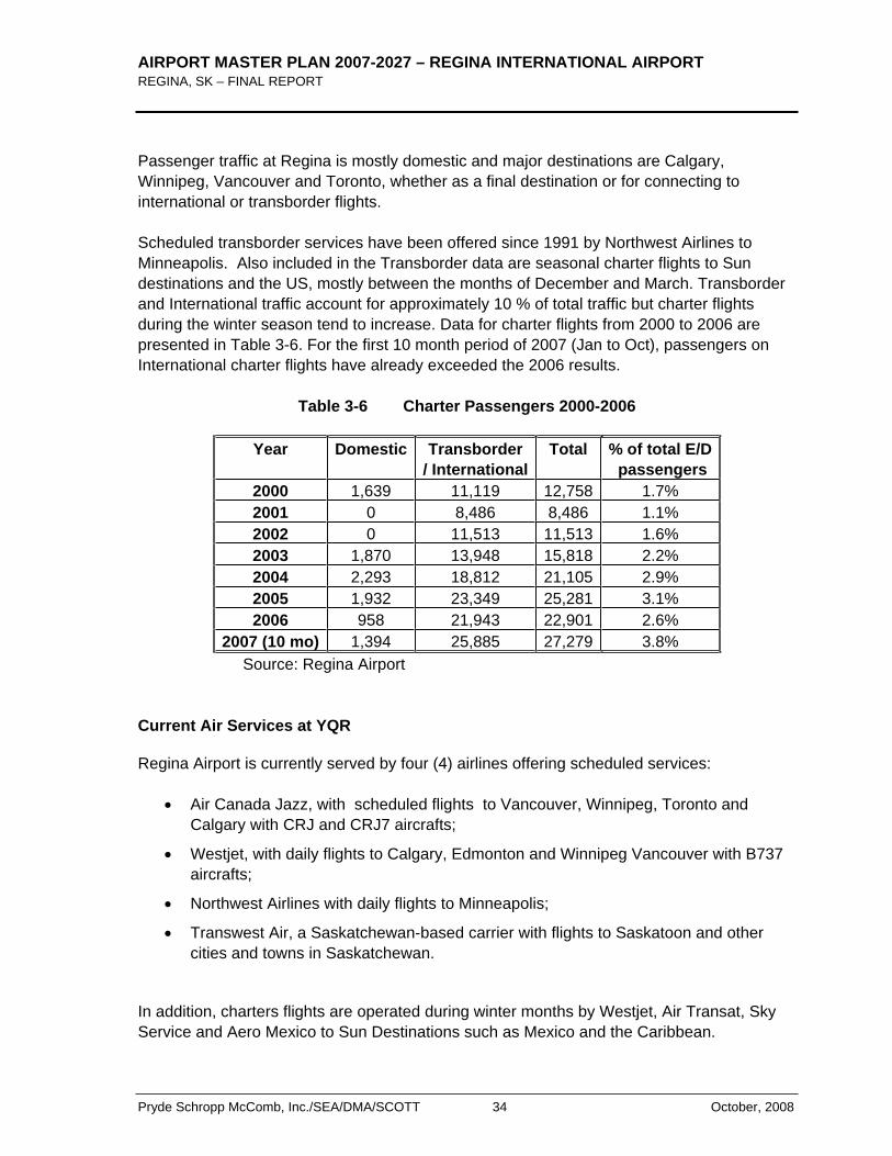
Passenger traffic at Regina is mostly domestic and major destinations are Calgary, Winnipeg, Vancouver and Toronto, whether as a final destination or for connecting to international or transborder flights.
Scheduled transborder services have been offered since 1991 by Northwest Airlines to Minneapolis. Also included in the Transborder data are seasonal charter flights to Sun destinations and the US, mostly between the months of December and March. Transborder and International traffic account for approximately 10 % of total traffic but charter flights during the winter season tend to increase. Data for charter flights from 2000 to 2006 are presented in Table 3-6. For the first 10 month period of 2007 (Jan to Oct), passengers on International charter flights have already exceeded the 2006 results.
Table 3-6 Charter Passengers 2000-2006
Year Domestic Transborder / International
Total % of total E/D passengers
2000 1,639 11,119 12,758 1.7% 2001 0 8,486 8,486 1.1% 2002 0 11,513 11,513 1.6% 2003 1,870 13,948 15,818 2.2% 2004 2,293 18,812 21,105 2.9% 2005 1,932 23,349 25,281 3.1% 2006 958 21,943 22,901 2.6%
2007 (10 mo) 1,394 25,885 27,279 3.8% Source: Regina Airport
Current Air Services at YQR
Regina Airport is currently served by four (4) airlines offering scheduled services:
Air Canada Jazz, with scheduled flights to Vancouver, Winnipeg, Toronto and Calgary with CRJ and CRJ7 aircrafts;
Westjet, with daily flights to Calgary, Edmonton and Winnipeg Vancouver with B737 aircrafts;
Northwest Airlines with daily flights to Minneapolis;
Transwest Air, a Saskatchewan-based carrier with flights to Saskatoon and other cities and towns in Saskatchewan.
In addition, charters flights are operated during winter months by Westjet, Air Transat, Sky Service and Aero Mexico to Sun Destinations such as Mexico and the Caribbean.
AIRPORT MASTER PLAN 2007-2027 – REGINA INTERNATIONAL AIRPORT REGINA, SK –FINAL REPORT
October, 2008 35 Pryde Schropp McComb, Inc./SEA/DMA/SCOTT
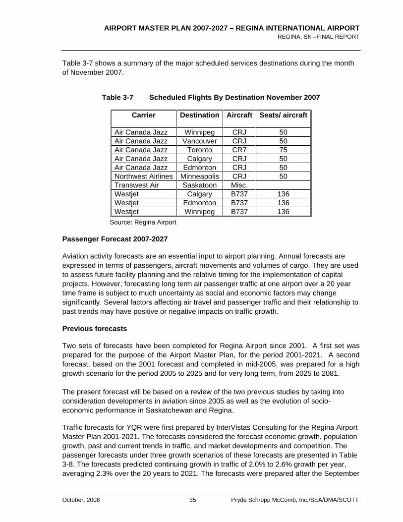
Table 3-7 shows a summary of the major scheduled services destinations during the month of November 2007.
Table 3-7 Scheduled Flights By Destination November 2007
Carrier Destination Aircraft Seats/ aircraft
Air Canada Jazz Winnipeg CRJ 50 Air Canada Jazz Vancouver CRJ 50 Air Canada Jazz Toronto CR7 75 Air Canada Jazz Calgary CRJ 50 Air Canada Jazz Edmonton CRJ 50 Northwest Airlines Minneapolis CRJ 50 Transwest Air Saskatoon Misc. Westjet Calgary B737 136 Westjet Edmonton B737 136 Westjet Winnipeg B737 136
Source: Regina Airport
Passenger Forecast 2007-2027
Aviation activity forecasts are an essential input to airport planning. Annual forecasts are expressed in terms of passengers, aircraft movements and volumes of cargo. They are used to assess future facility planning and the relative timing for the implementation of capital projects. However, forecasting long term air passenger traffic at one airport over a 20 year time frame is subject to much uncertainty as social and economic factors may change significantly. Several factors affecting air travel and passenger traffic and their relationship to past trends may have positive or negative impacts on traffic growth.
Previous forecasts
Two sets of forecasts have been completed for Regina Airport since 2001. A first set was prepared for the purpose of the Airport Master Plan, for the period 2001-2021. A second forecast, based on the 2001 forecast and completed in mid-2005, was prepared for a high growth scenario for the period 2005 to 2025 and for very long term, from 2025 to 2081.
The present forecast will be based on a review of the two previous studies by taking into consideration developments in aviation since 2005 as well as the evolution of socio-economic performance in Saskatchewan and Regina.
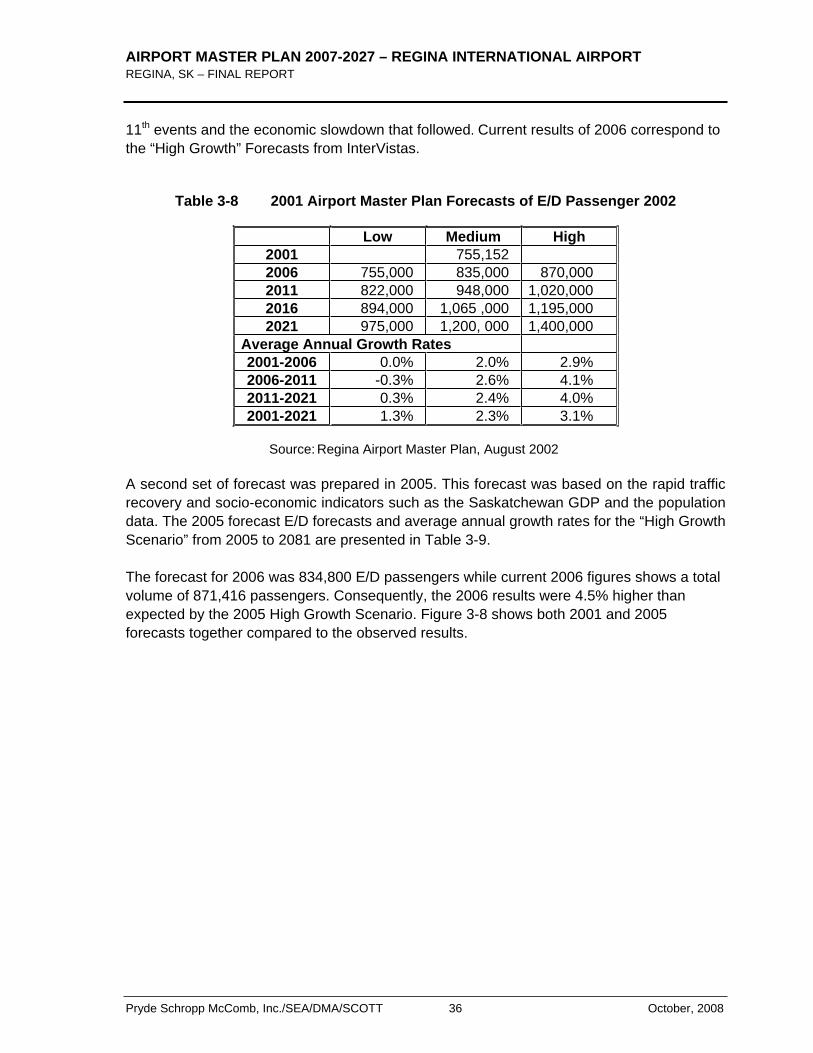
Traffic forecasts for YQR were first prepared by InterVistas Consulting for the Regina Airport Master Plan 2001-2021. The forecasts considered the forecast economic growth, population growth, past and current trends in traffic, and market developments and competition. The passenger forecasts under three growth scenarios of these forecasts are presented in Table 3-8. The forecasts predicted continuing growth in traffic of 2.0% to 2.6% growth per year, averaging 2.3% over the 20 years to 2021. The forecasts were prepared after the September
AIRPORT MASTER PLAN 2007-2027 – REGINA INTERNATIONAL AIRPORT REGINA, SK – FINAL REPORT
Pryde Schropp McComb, Inc./SEA/DMA/SCOTT 36 October, 2008
11th events and the economic slowdown that followed. Current results of 2006 correspond to the “High Growth” Forecasts from InterVistas.
Table 3-8 2001 Airport Master Plan Forecasts of E/D Passenger 2002
Low Medium High 2001 755,152 2006 755,000 835,000 870,000 2011 822,000 948,000 1,020,000 2016 894,000 1,065 ,000 1,195,000 2021 975,000 1,200, 000 1,400,000
Average Annual Growth Rates 2001-2006 0.0% 2.0% 2.9% 2006-2011 -0.3% 2.6% 4.1% 2011-2021 0.3% 2.4% 4.0% 2001-2021 1.3% 2.3% 3.1%
Source: Regina Airport Master Plan, August 2002
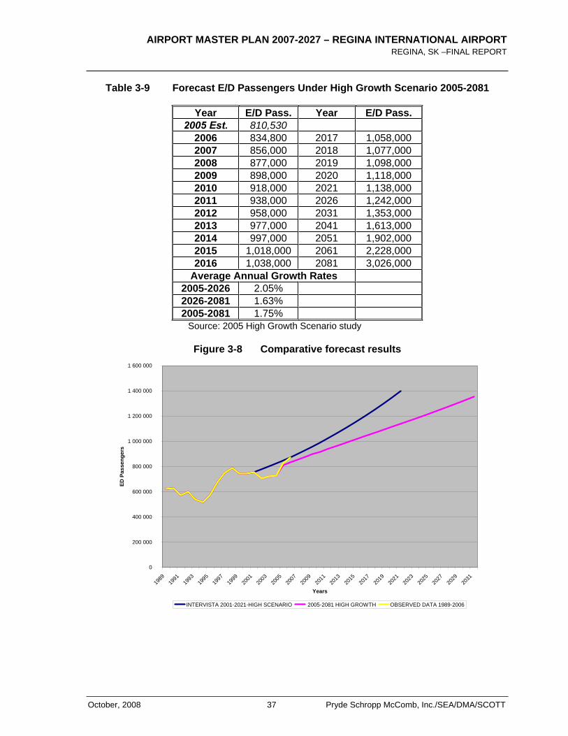
A second set of forecast was prepared in 2005. This forecast was based on the rapid traffic recovery and socio-economic indicators such as the Saskatchewan GDP and the population data. The 2005 forecast E/D forecasts and average annual growth rates for the “High Growth Scenario” from 2005 to 2081 are presented in Table 3-9.
The forecast for 2006 was 834,800 E/D passengers while current 2006 figures shows a total volume of 871,416 passengers. Consequently, the 2006 results were 4.5% higher than expected by the 2005 High Growth Scenario. Figure 3-8 shows both 2001 and 2005 forecasts together compared to the observed results.
AIRPORT MASTER PLAN 2007-2027 – REGINA INTERNATIONAL AIRPORT REGINA, SK –FINAL REPORT
October, 2008 37 Pryde Schropp McComb, Inc./SEA/DMA/SCOTT
Table 3-9 Forecast E/D Passengers Under High Growth Scenario 2005-2081
Year E/D Pass. Year E/D Pass. 2005 Est. 810,530
2006 834,800 2017 1,058,000 2007 856,000 2018 1,077,000 2008 877,000 2019 1,098,000 2009 898,000 2020 1,118,000 2010 918,000 2021 1,138,000 2011 938,000 2026 1,242,000 2012 958,000 2031 1,353,000 2013 977,000 2041 1,613,000 2014 997,000 2051 1,902,000 2015 1,018,000 2061 2,228,000 2016 1,038,000 2081 3,026,000
Average Annual Growth Rates 2005-2026 2.05% 2026-2081 1.63% 2005-2081 1.75%
Source: 2005 High Growth Scenario study
Figure 3-8 Comparative forecast results
0
200 000
400 000
600 000
800 000
1 000 000
1 200 000
1 400 000
1 600 000
1989
1991
1993
1995
1997
1999
2001
2003
2005
2007
2009
2011
2013
2015
2017
2019
2021
2023
2025
2027
2029
2031
Years
ED P
asse
nger
s
INTERVISTA 2001-2021-HIGH SCENARIO 2005-2081 HIGH GROWTH OBSERVED DATA 1989-2006
AIRPORT MASTER PLAN 2007-2027 – REGINA INTERNATIONAL AIRPORT REGINA, SK – FINAL REPORT
Pryde Schropp McComb, Inc./SEA/DMA/SCOTT 38 October, 2008
Global forecasts
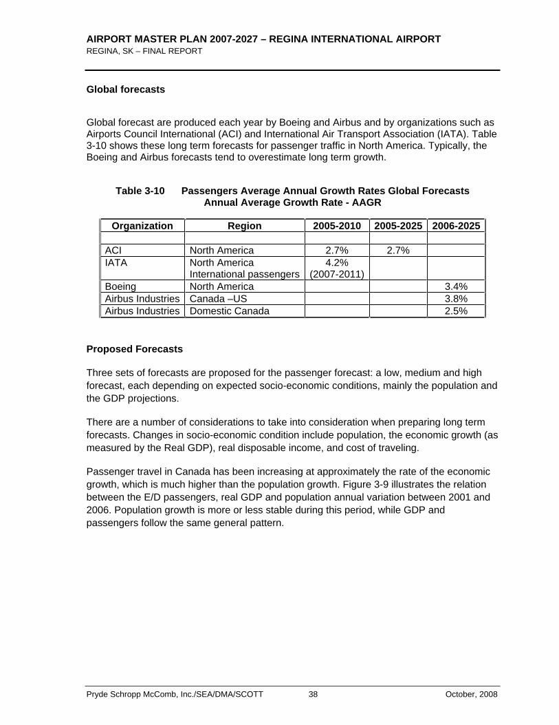
Global forecast are produced each year by Boeing and Airbus and by organizations such as Airports Council International (ACI) and International Air Transport Association (IATA). Table 3-10 shows these long term forecasts for passenger traffic in North America. Typically, the Boeing and Airbus forecasts tend to overestimate long term growth.
Table 3-10 Passengers Average Annual Growth Rates Global Forecasts Annual Average Growth Rate - AAGR
Organization Region 2005-2010 2005-2025 2006-2025 ACI North America 2.7% 2.7% IATA North America
International passengers4.2%
(2007-2011)Boeing North America 3.4% Airbus Industries Canada –US 3.8% Airbus Industries Domestic Canada 2.5%
Proposed Forecasts
Three sets of forecasts are proposed for the passenger forecast: a low, medium and high forecast, each depending on expected socio-economic conditions, mainly the population and the GDP projections.
There are a number of considerations to take into consideration when preparing long term forecasts. Changes in socio-economic condition include population, the economic growth (as measured by the Real GDP), real disposable income, and cost of traveling.
Passenger travel in Canada has been increasing at approximately the rate of the economic growth, which is much higher than the population growth. Figure 3-9 illustrates the relation between the E/D passengers, real GDP and population annual variation between 2001 and 2006. Population growth is more or less stable during this period, while GDP and passengers follow the same general pattern.
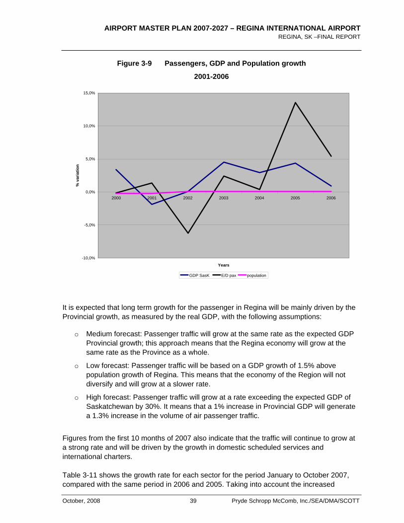
AIRPORT MASTER PLAN 2007-2027 – REGINA INTERNATIONAL AIRPORT REGINA, SK –FINAL REPORT
October, 2008 39 Pryde Schropp McComb, Inc./SEA/DMA/SCOTT
Figure 3-9 Passengers, GDP and Population growth
2001-2006
-10,0%
-5,0%
0,0%
5,0%
10,0%
15,0%
2000 2001 2002 2003 2004 2005 2006
Years
% v
aria
tion
GDP SasK E/D pax population
It is expected that long term growth for the passenger in Regina will be mainly driven by the Provincial growth, as measured by the real GDP, with the following assumptions:
o Medium forecast: Passenger traffic will grow at the same rate as the expected GDP Provincial growth; this approach means that the Regina economy will grow at the same rate as the Province as a whole.
o Low forecast: Passenger traffic will be based on a GDP growth of 1.5% above population growth of Regina. This means that the economy of the Region will not diversify and will grow at a slower rate.
o High forecast: Passenger traffic will grow at a rate exceeding the expected GDP of Saskatchewan by 30%. It means that a 1% increase in Provincial GDP will generate a 1.3% increase in the volume of air passenger traffic.
Figures from the first 10 months of 2007 also indicate that the traffic will continue to grow at a strong rate and will be driven by the growth in domestic scheduled services and international charters.
Table 3-11 shows the growth rate for each sector for the period January to October 2007, compared with the same period in 2006 and 2005. Taking into account the increased
AIRPORT MASTER PLAN 2007-2027 – REGINA INTERNATIONAL AIRPORT REGINA, SK – FINAL REPORT
Pryde Schropp McComb, Inc./SEA/DMA/SCOTT 40 October, 2008
schedule for charters in December 2007 as well as the variation in the various sectors, it is expected that the traffic will reach 960,000 passengers by the end of 2007. This E/D volume represents a 10.2% increase over 2006.
Table 3-11 2007 Expected Traffic Growth at Regina Airport
Period Domestic scheduled
DomesticCharters
TBscheduled
TB and International
charters
Total
Jan-Oct 07/ Jan-Oct 06
10.5% 45.5% -0.5% 42.9% 9.8%
Jan-Oct 06 / Jan-Oct 05
6.9% -50.4% -7.3% -12.0% 5.1%
Jan-Oct 05 / Jan-Oct 04
14.3% -15.7% 6.6% 13.9% 13.9%
Source: Regina Airport monthly data
Table 3-12 and Figure 3-10 show the results for the three scenarios, for the period 2007 to 2027, with a projection up to 2030. Because of its role as a national airport and the positive economic outlook for the region and the province, Regina Airport traffic should grow significantly over the planning horizon. In the medium forecast scenario, traffic is expected to grow at an annual average rate of 2.3% over the next 20 years, thus reaching over 1.2 million passengers in 2017 and 1.5 million in 2027. The low scenario expects 1.4 million passengers in 2027 and over 1.7 million for the high scenario.
Table 3-12 E/D Passenger Forecast 2007-2027
YearLOW
FORECAST LOW
FORECAST MEDIUMFORECAST
MEDIUM FORECAST
HIGHFORECAST
Populationrate plus
1.5% Passengers GDPx1 Passengers GDP% x1,3 Passengers
2006 871 416 871 416 871 4162007 960 000 960 000 960 0002008 2.07% 980 000 3.00% 989000 3.90% 9980002009 2.07% 1 000 000 2.70% 1 016 000 3.51% 1 033 0002010 2.07% 1 021 000 2.70% 1 043 000 3.51% 1 069 0002011 2,07% 1 042 000 2.50% 1 069 000 3.25% 1 104 0002012 2.05% 1 064 000 2.50% 1 096 000 3.25% 1 139 0002013 2.05% 1 086 000 2.50% 1 123 000 3.25% 1 176 0002014 2.0% 1 107 000 2.50% 1 151 000 3.25% 1 215 0002015 2.00% 1 130 000 2.50% 1 180 000 3.25% 1 254 000
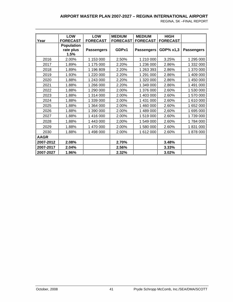
AIRPORT MASTER PLAN 2007-2027 – REGINA INTERNATIONAL AIRPORT REGINA, SK –FINAL REPORT
October, 2008 41 Pryde Schropp McComb, Inc./SEA/DMA/SCOTT
YearLOW
FORECAST LOW
FORECAST MEDIUMFORECAST
MEDIUM FORECAST
HIGHFORECAST
Populationrate plus
1.5% Passengers GDPx1 Passengers GDP% x1,3 Passengers
2016 2.00% 1 153 000 2.50% 1 210 000 3.25% 1 295 0002017 1.89% 1 175 000 2.20% 1 236 000 2.86% 1 332 0002018 1.89% 1 196 809 2.20% 1 263 393 2.86% 1 370 0002019 1.93% 1 220 000 2.20% 1 291 000 2.86% 1 409 0002020 1.88% 1 243 000 2.20% 1 320 000 2.86% 1 450 0002021 1.88% 1 266 000 2.20% 1 349 000 2.86% 1 491 0002022 1.88% 1 290 000 2.00% 1 376 000 2.60% 1 530 0002023 1.88% 1 314 000 2.00% 1 403 000 2.60% 1 570 0002024 1.88% 1 339 000 2.00% 1 431 000 2.60% 1 610 0002025 1.88% 1 364 000 2.00% 1 460 000 2.60% 1 652 0002026 1.88% 1 390 000 2.00% 1 489 000 2,60% 1 695 0002027 1.88% 1 416 000 2.00% 1 519 000 2.60% 1 739 0002028 1.88% 1 443 000 2,00% 1 549 000 2.60% 1 784 0002029 1.88% 1 470 000 2.00% 1 580 000 2.60% 1 831 0002030 1.88% 1 498 000 2.00% 1 612 000 2.60% 1 878 000
AAGR 2007-2012 2.08% 2.70% 3.48% 2007-2017 2.04% 2.56% 3.33% 2007-2027 1.96% 2.32% 3.02%
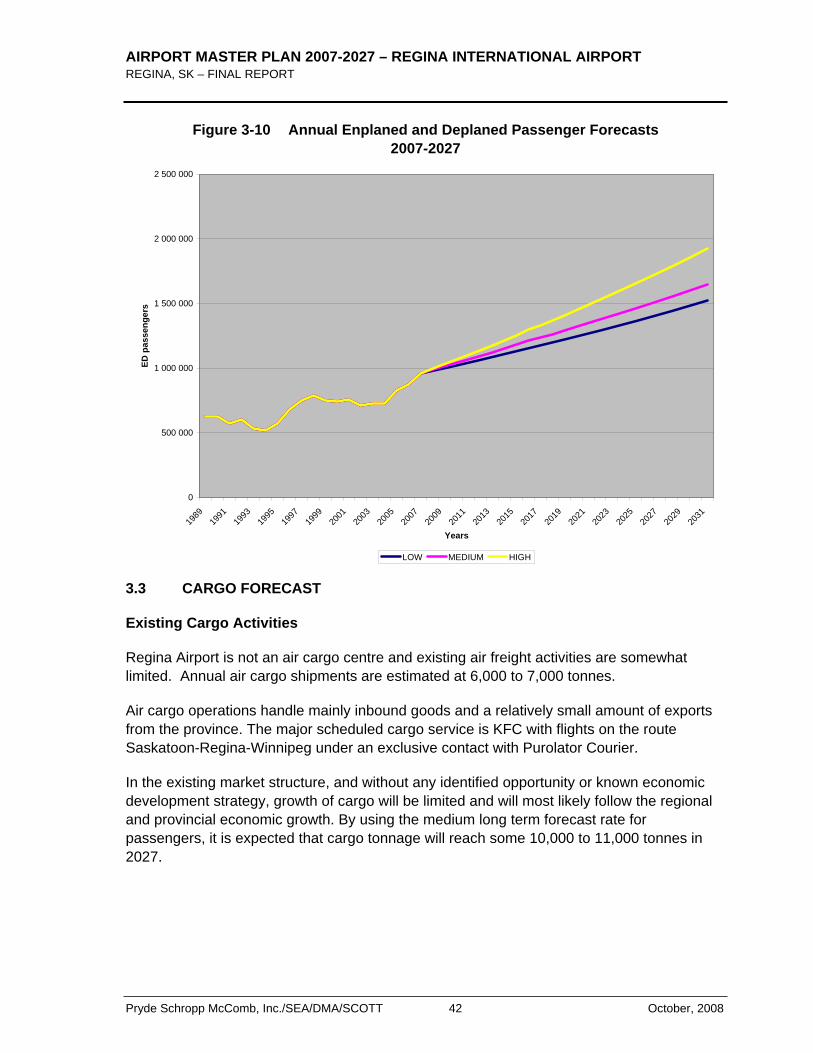
AIRPORT MASTER PLAN 2007-2027 – REGINA INTERNATIONAL AIRPORT REGINA, SK – FINAL REPORT
Pryde Schropp McComb, Inc./SEA/DMA/SCOTT 42 October, 2008
Figure 3-10 Annual Enplaned and Deplaned Passenger Forecasts 2007-2027
0
500 000
1 000 000
1 500 000
2 000 000
2 500 000
1989
1991
1993
1995
1997
1999
2001
2003
2005
2007
2009
2011
2013
2015
2017
2019
2021
2023
2025
2027
2029
2031
Years
ED p
asse
nger
s
LOW MEDIUM HIGH
3.3 CARGO FORECAST
Existing Cargo Activities
Regina Airport is not an air cargo centre and existing air freight activities are somewhat limited. Annual air cargo shipments are estimated at 6,000 to 7,000 tonnes.
Air cargo operations handle mainly inbound goods and a relatively small amount of exports from the province. The major scheduled cargo service is KFC with flights on the route Saskatoon-Regina-Winnipeg under an exclusive contact with Purolator Courier.
In the existing market structure, and without any identified opportunity or known economic development strategy, growth of cargo will be limited and will most likely follow the regional and provincial economic growth. By using the medium long term forecast rate for passengers, it is expected that cargo tonnage will reach some 10,000 to 11,000 tonnes in 2027.
AIRPORT MASTER PLAN 2007-2027 – REGINA INTERNATIONAL AIRPORT REGINA, SK –FINAL REPORT
October, 2008 43 Pryde Schropp McComb, Inc./SEA/DMA/SCOTT
3.4 AIRCRAFT ACTIVITY
Definitions
An aircraft movement is a take off, a landing or a simulated approach by an aircraft. Two classes of operations are considered: local and itinerant movements. Itinerant movements are those for which aircraft proceed to or arrive from another location or exit the circuit of the control tower. Local movements are those in which the aircraft remains in the circuit of the control tower. Aircraft activity also includes numerous categories of aircraft movements, including commercial, private, government or military activity. Data are also collected according to maximum take-off weight of aircraft or by type of power plant. The data are collected by Nav Canada and published by Statistics Canada and Transport Canada.
Historical Activity
Total Movements
Between 1996 and 2006, total aircraft activity in Regina, measured in terms of total movements, declined until 2004 as shown in Figure 3-11 and Table 3-13. This decline is observed for both itinerant and local movements. After a peak in 1998, aircraft movements declined until 2004. From then on, they increased in 2005 and 2006.
In Canada, total aircraft movements have generally also been declining steadily since a peak was reached in 1999. However, the number of movements in Canada increased in 2006 by 2.9%, their first increase since 1999, while total growth in Regina reached 11.1%, one of the top airports in Canada for growth for a second year in row.
Itinerant movements declined steadily between 1996 and 2004, going form 49,913 movements in 1996 to 35,624 in 2004. In 2005 and 2006, they increased by 9.3% per year. Some cyclical variations are observed for local movements. From a total of 15,223 in 1996, they varied annually and reached a low of 11,400 in 2005. In 2006, they increased by 36% and reached a total of 15,485, the same level as in 1996. In 2006, itinerant movements represented 73.3% of total movements. By comparison, the share of itinerant movements in 42 Airports with control towers in Canada was 71% in 2006.
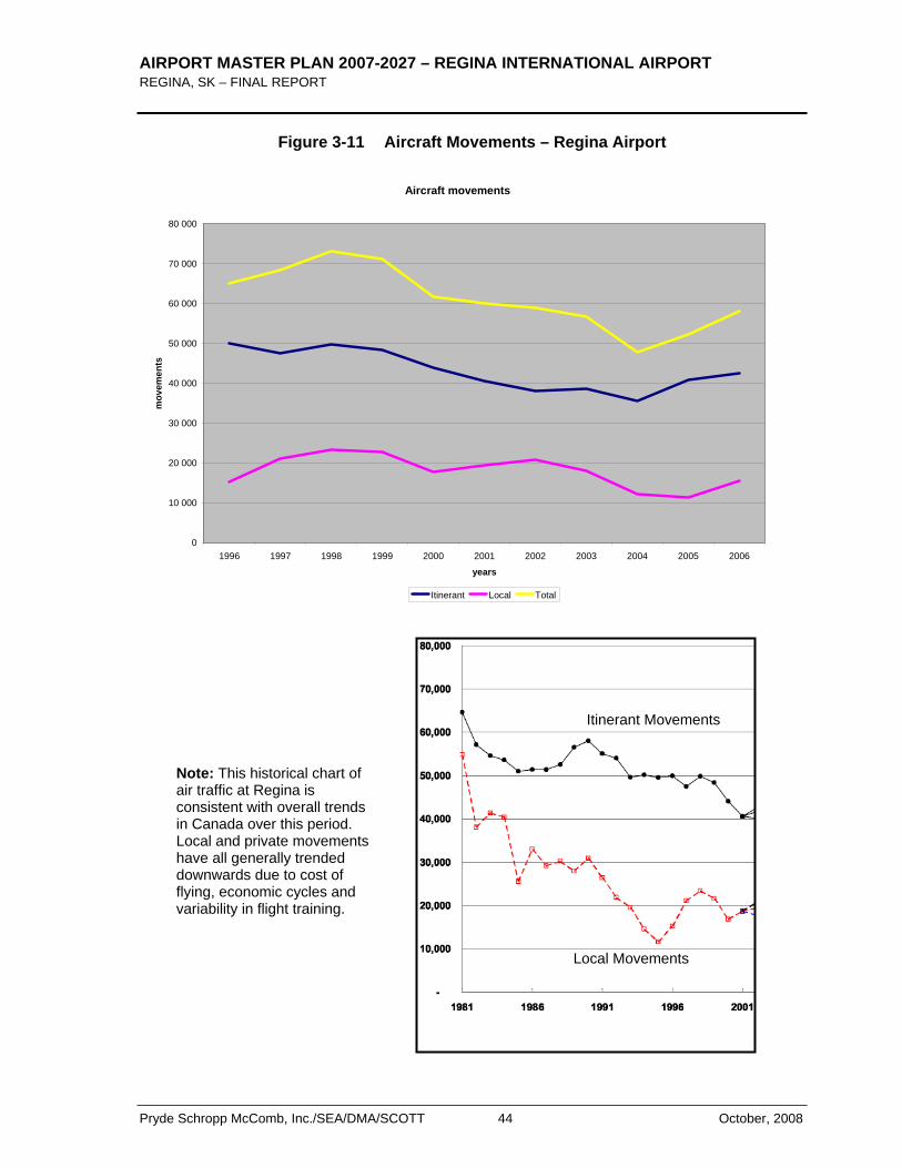
AIRPORT MASTER PLAN 2007-2027 – REGINA INTERNATIONAL AIRPORT REGINA, SK – FINAL REPORT
Pryde Schropp McComb, Inc./SEA/DMA/SCOTT 44 October, 2008
Figure 3-11 Aircraft Movements – Regina Airport
Aircraft movements
0
10 000
20 000
30 000
40 000
50 000
60 000
70 000
80 000
1996 1997 1998 1999 2000 2001 2002 2003 2004 2005 2006
years
mov
emen
ts
Itinerant Local Total
Local Movements
Itinerant Movements
Note: This historical chart of air traffic at Regina is consistent with overall trends in Canada over this period. Local and private movements have all generally trended downwards due to cost of flying, economic cycles and variability in flight training.
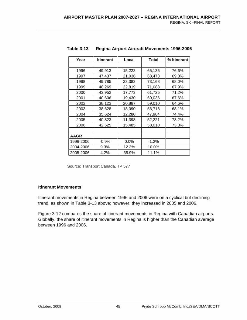
AIRPORT MASTER PLAN 2007-2027 – REGINA INTERNATIONAL AIRPORT REGINA, SK –FINAL REPORT
October, 2008 45 Pryde Schropp McComb, Inc./SEA/DMA/SCOTT
Table 3-13 Regina Airport Aircraft Movements 1996-2006
Year Itinerant Local Total % Itinerant
1996 49,913 15,223 65,136 76.6% 1997 47,437 21,036 68,473 69.3% 1998 49,785 23,383 73,168 68.0% 1999 48,269 22,819 71,088 67.9% 2000 43,952 17,773 61,725 71.2% 2001 40,606 19,430 60,036 67.6% 2002 38,123 20,887 59,010 64.6% 2003 38,628 18,090 56,718 68.1% 2004 35,624 12,280 47,904 74.4% 2005 40,823 11,398 52,221 78.2% 2006 42,525 15,485 58,010 73.3%
AAGR 1996-2006 -0.9% 0.0% -1.2% 2004-2006 9.3% 12.3% 10.0% 2005-2006 4.2% 35.9% 11.1%
Source: Transport Canada, TP 577
Itinerant Movements
Itinerant movements in Regina between 1996 and 2006 were on a cyclical but declining trend, as shown in Table 3-13 above; however, they increased in 2005 and 2006.
Figure 3-12 compares the share of itinerant movements in Regina with Canadian airports. Globally, the share of itinerant movements in Regina is higher than the Canadian average between 1996 and 2006.
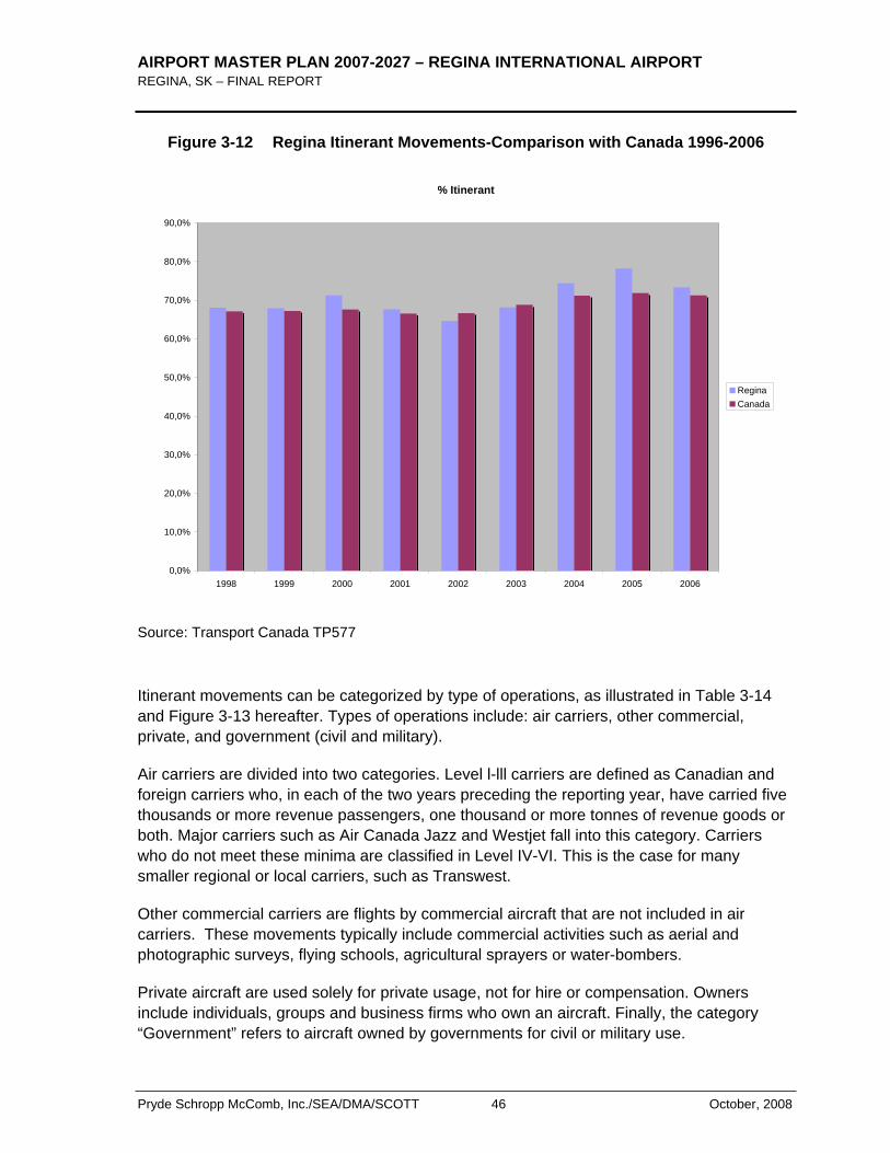
AIRPORT MASTER PLAN 2007-2027 – REGINA INTERNATIONAL AIRPORT REGINA, SK – FINAL REPORT
Pryde Schropp McComb, Inc./SEA/DMA/SCOTT 46 October, 2008
Figure 3-12 Regina Itinerant Movements-Comparison with Canada 1996-2006
% Itinerant
0,0%
10,0%
20,0%
30,0%
40,0%
50,0%
60,0%
70,0%
80,0%
90,0%
1998 1999 2000 2001 2002 2003 2004 2005 2006
ReginaCanada
Source: Transport Canada TP577
Itinerant movements can be categorized by type of operations, as illustrated in Table 3-14 and Figure 3-13 hereafter. Types of operations include: air carriers, other commercial, private, and government (civil and military).
Air carriers are divided into two categories. Level l-lll carriers are defined as Canadian and foreign carriers who, in each of the two years preceding the reporting year, have carried five thousands or more revenue passengers, one thousand or more tonnes of revenue goods or both. Major carriers such as Air Canada Jazz and Westjet fall into this category. Carriers who do not meet these minima are classified in Level IV-VI. This is the case for many smaller regional or local carriers, such as Transwest.
Other commercial carriers are flights by commercial aircraft that are not included in air carriers. These movements typically include commercial activities such as aerial and photographic surveys, flying schools, agricultural sprayers or water-bombers.
Private aircraft are used solely for private usage, not for hire or compensation. Owners include individuals, groups and business firms who own an aircraft. Finally, the category “Government” refers to aircraft owned by governments for civil or military use.
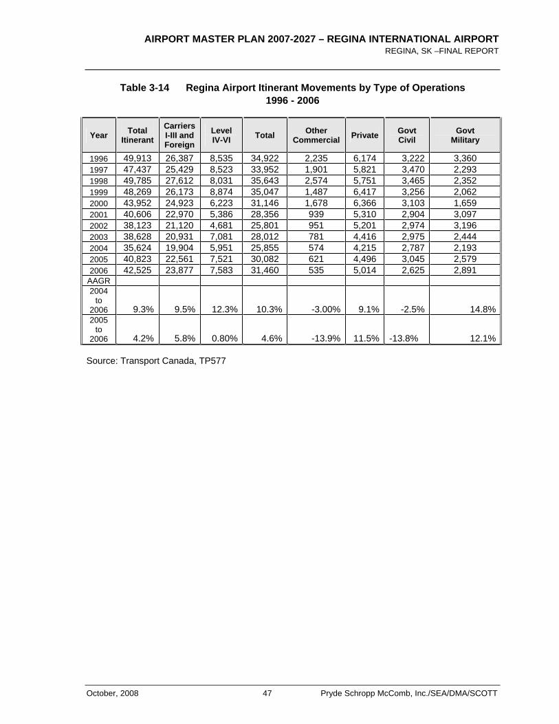
AIRPORT MASTER PLAN 2007-2027 – REGINA INTERNATIONAL AIRPORT REGINA, SK –FINAL REPORT
October, 2008 47 Pryde Schropp McComb, Inc./SEA/DMA/SCOTT
Table 3-14 Regina Airport Itinerant Movements by Type of Operations 1996 - 2006
Year Total Itinerant
Carriers I-III and Foreign
Level IV-VI Total Other
Commercial Private Govt Civil
Govt Military
1996 49,913 26,387 8,535 34,922 2,235 6,174 3,222 3,360 1997 47,437 25,429 8,523 33,952 1,901 5,821 3,470 2,293 1998 49,785 27,612 8,031 35,643 2,574 5,751 3,465 2,352 1999 48,269 26,173 8,874 35,047 1,487 6,417 3,256 2,062 2000 43,952 24,923 6,223 31,146 1,678 6,366 3,103 1,659 2001 40,606 22,970 5,386 28,356 939 5,310 2,904 3,097 2002 38,123 21,120 4,681 25,801 951 5,201 2,974 3,196 2003 38,628 20,931 7,081 28,012 781 4,416 2,975 2,444 2004 35,624 19,904 5,951 25,855 574 4,215 2,787 2,193 2005 40,823 22,561 7,521 30,082 621 4,496 3,045 2,579 2006 42,525 23,877 7,583 31,460 535 5,014 2,625 2,891
AAGR 2004
to2006 9.3% 9.5% 12.3% 10.3% -3.00% 9.1% -2.5% 14.8%2005
to2006 4.2% 5.8% 0.80% 4.6% -13.9% 11.5% -13.8% 12.1%
Source: Transport Canada, TP577
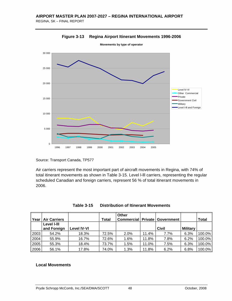
AIRPORT MASTER PLAN 2007-2027 – REGINA INTERNATIONAL AIRPORT REGINA, SK – FINAL REPORT
Pryde Schropp McComb, Inc./SEA/DMA/SCOTT 48 October, 2008
Figure 3-13 Regina Airport Itinerant Movements 1996-2006
Movements by type of operator
0
5 000
10 000
15 000
20 000
25 000
30 000
1996 1997 1998 1999 2000 2001 2002 2003 2004 2005
Level lV-VlOther CommercialPrivateGovernment CivilMilitaryLevel l-lll and Foreign
Source: Transport Canada, TP577
Air carriers represent the most important part of aircraft movements in Regina, with 74% of total itinerant movements as shown in Table 3-15. Level l-lll carriers, representing the regular scheduled Canadian and foreign carriers, represent 56 % of total itinerant movements in 2006.
Table 3-15 Distribution of Itinerant Movements
Year Air Carriers Total Other Commercial Private Government Total
Level l-lll and Foreign Level lV-Vl Civil Military
2003 54.2% 18.3% 72.5% 2.0% 11.4% 7.7% 6.3% 100.0%2004 55.9% 16.7% 72.6% 1.6% 11.8% 7.8% 6.2% 100.0%2005 55.3% 18.4% 73.7% 1.5% 11.0% 7.5% 6.3% 100.0%2006 56.1% 17.8% 74.0% 1.3% 11.8% 6.2% 6.8% 100.0%
Local Movements
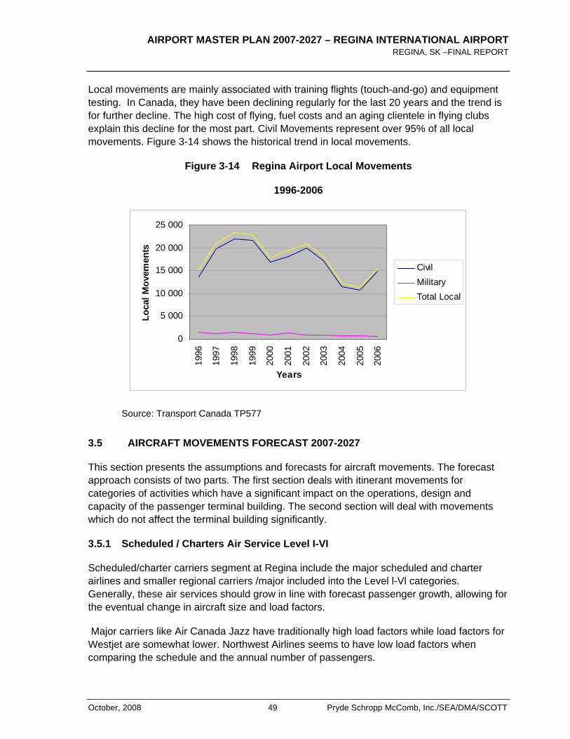
AIRPORT MASTER PLAN 2007-2027 – REGINA INTERNATIONAL AIRPORT REGINA, SK –FINAL REPORT
October, 2008 49 Pryde Schropp McComb, Inc./SEA/DMA/SCOTT
Local movements are mainly associated with training flights (touch-and-go) and equipment testing. In Canada, they have been declining regularly for the last 20 years and the trend is for further decline. The high cost of flying, fuel costs and an aging clientele in flying clubs explain this decline for the most part. Civil Movements represent over 95% of all local movements. Figure 3-14 shows the historical trend in local movements.
Figure 3-14 Regina Airport Local Movements
1996-2006
0
5 000
10 000
15 000
20 000
25 000
1996
1997
1998
1999
2000
2001
2002
2003
2004
2005
2006
Years
Loca
l Mov
emen
ts
CivilMilitaryTotal Local
Source: Transport Canada TP577
3.5 AIRCRAFT MOVEMENTS FORECAST 2007-2027
This section presents the assumptions and forecasts for aircraft movements. The forecast approach consists of two parts. The first section deals with itinerant movements for categories of activities which have a significant impact on the operations, design and capacity of the passenger terminal building. The second section will deal with movements which do not affect the terminal building significantly.
3.5.1 Scheduled / Charters Air Service Level I-VI
Scheduled/charter carriers segment at Regina include the major scheduled and charter airlines and smaller regional carriers /major included into the Level l-Vl categories. Generally, these air services should grow in line with forecast passenger growth, allowing for the eventual change in aircraft size and load factors.
Major carriers like Air Canada Jazz have traditionally high load factors while load factors for Westjet are somewhat lower. Northwest Airlines seems to have low load factors when comparing the schedule and the annual number of passengers.
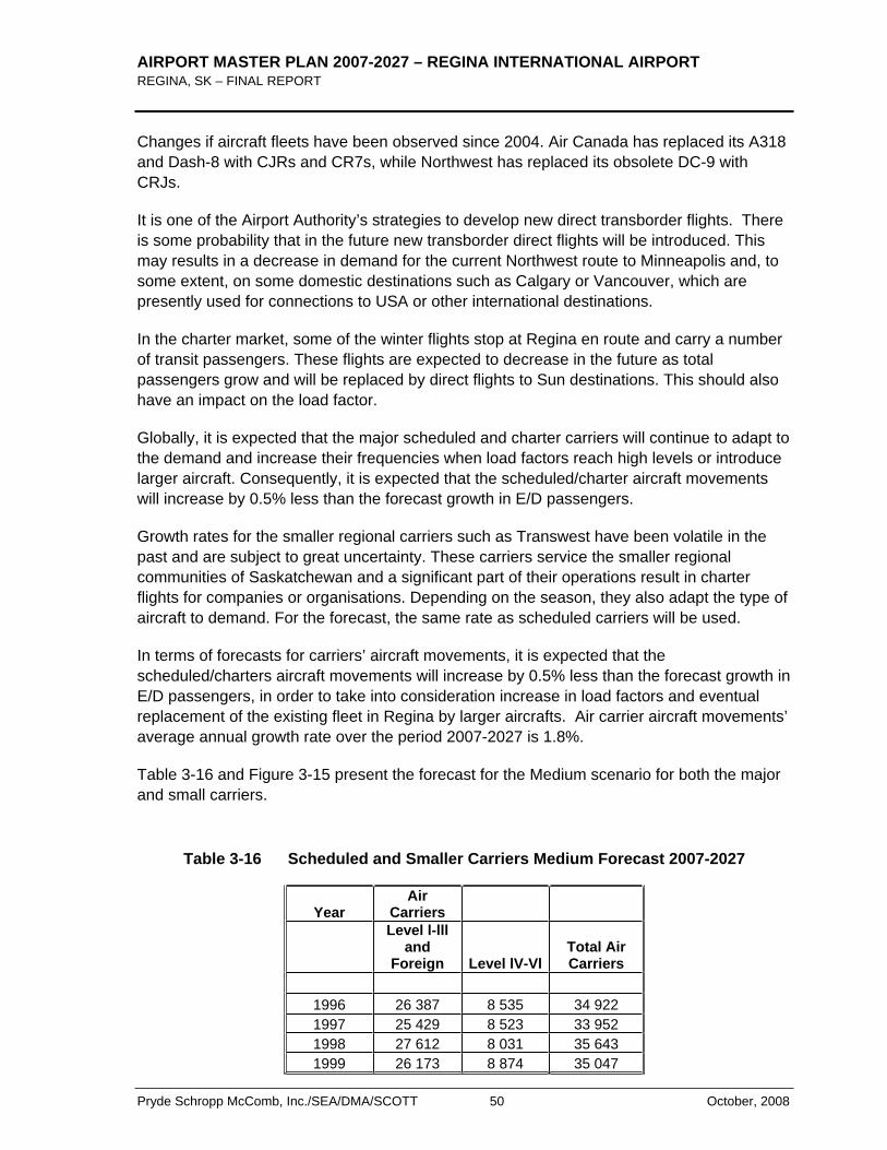
AIRPORT MASTER PLAN 2007-2027 – REGINA INTERNATIONAL AIRPORT REGINA, SK – FINAL REPORT
Pryde Schropp McComb, Inc./SEA/DMA/SCOTT 50 October, 2008
Changes if aircraft fleets have been observed since 2004. Air Canada has replaced its A318 and Dash-8 with CJRs and CR7s, while Northwest has replaced its obsolete DC-9 with CRJs.
It is one of the Airport Authority’s strategies to develop new direct transborder flights. There is some probability that in the future new transborder direct flights will be introduced. This may results in a decrease in demand for the current Northwest route to Minneapolis and, to some extent, on some domestic destinations such as Calgary or Vancouver, which are presently used for connections to USA or other international destinations.
In the charter market, some of the winter flights stop at Regina en route and carry a number of transit passengers. These flights are expected to decrease in the future as total passengers grow and will be replaced by direct flights to Sun destinations. This should also have an impact on the load factor.
Globally, it is expected that the major scheduled and charter carriers will continue to adapt to the demand and increase their frequencies when load factors reach high levels or introduce larger aircraft. Consequently, it is expected that the scheduled/charter aircraft movements will increase by 0.5% less than the forecast growth in E/D passengers.
Growth rates for the smaller regional carriers such as Transwest have been volatile in the past and are subject to great uncertainty. These carriers service the smaller regional communities of Saskatchewan and a significant part of their operations result in charter flights for companies or organisations. Depending on the season, they also adapt the type of aircraft to demand. For the forecast, the same rate as scheduled carriers will be used.
In terms of forecasts for carriers’ aircraft movements, it is expected that the scheduled/charters aircraft movements will increase by 0.5% less than the forecast growth in E/D passengers, in order to take into consideration increase in load factors and eventual replacement of the existing fleet in Regina by larger aircrafts. Air carrier aircraft movements’ average annual growth rate over the period 2007-2027 is 1.8%.
Table 3-16 and Figure 3-15 present the forecast for the Medium scenario for both the major and small carriers.
Table 3-16 Scheduled and Smaller Carriers Medium Forecast 2007-2027
YearAir
Carriers Level l-lll
andForeign Level lV-Vl
Total Air Carriers
1996 26 387 8 535 34 922 1997 25 429 8 523 33 952 1998 27 612 8 031 35 643 1999 26 173 8 874 35 047
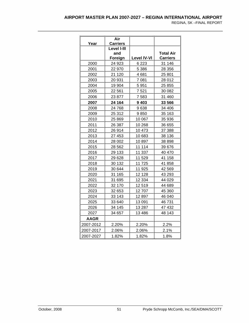
AIRPORT MASTER PLAN 2007-2027 – REGINA INTERNATIONAL AIRPORT REGINA, SK –FINAL REPORT
October, 2008 51 Pryde Schropp McComb, Inc./SEA/DMA/SCOTT
YearAir
Carriers Level l-lll
andForeign Level lV-Vl
Total Air Carriers
2000 24 923 6 223 31 146 2001 22 970 5 386 28 356 2002 21 120 4 681 25 801 2003 20 931 7 081 28 012 2004 19 904 5 951 25 855 2005 22 561 7 521 30 082 2006 23 877 7 583 31 460 2007 24 164 9 403 33 566 2008 24 768 9 638 34 406 2009 25 312 9 850 35 163 2010 25 869 10 067 35 936 2011 26 387 10 268 36 655 2012 26 914 10 473 37 388 2013 27 453 10 683 38 136 2014 28 002 10 897 38 898 2015 28 562 11 114 39 676 2016 29 133 11 337 40 470 2017 29 628 11 529 41 158 2018 30 132 11 725 41 858 2019 30 644 11 925 42 569 2020 31 165 12 128 43 293 2021 31 695 12 334 44 029 2022 32 170 12 519 44 689 2023 32 653 12 707 45 360 2024 33 143 12 897 46 040 2025 33 640 13 091 46 731 2026 34 145 13 287 47 432 2027 34 657 13 486 48 143
AAGR 2007-2012 2.20% 2.20% 2.2% 2007-2017 2.06% 2.06% 2.1% 2007-2027 1.82% 1.82% 1.8%
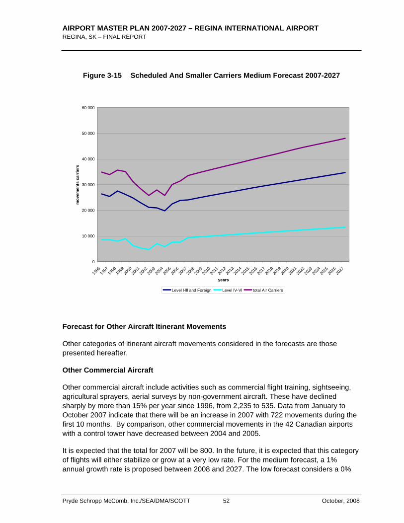
AIRPORT MASTER PLAN 2007-2027 – REGINA INTERNATIONAL AIRPORT REGINA, SK – FINAL REPORT
Pryde Schropp McComb, Inc./SEA/DMA/SCOTT 52 October, 2008
Figure 3-15 Scheduled And Smaller Carriers Medium Forecast 2007-2027
0
10 000
20 000
30 000
40 000
50 000
60 000
1996
1997
1998
1999
2000
2001
2002
2003
2004
2005
2006
2007
2008
2009
2010
2011
2012
2013
2014
2015
2016
2017
2018
2019
2020
2021
2022
2023
2024
2025
2026
2027
years
mov
emen
ts c
arrie
rs
Level l-lll and Foreign Level lV-Vl total Air Carriers
Forecast for Other Aircraft Itinerant Movements
Other categories of itinerant aircraft movements considered in the forecasts are those presented hereafter.
Other Commercial Aircraft
Other commercial aircraft include activities such as commercial flight training, sightseeing, agricultural sprayers, aerial surveys by non-government aircraft. These have declined sharply by more than 15% per year since 1996, from 2,235 to 535. Data from January to October 2007 indicate that there will be an increase in 2007 with 722 movements during the first 10 months. By comparison, other commercial movements in the 42 Canadian airports with a control tower have decreased between 2004 and 2005.
It is expected that the total for 2007 will be 800. In the future, it is expected that this category of flights will either stabilize or grow at a very low rate. For the medium forecast, a 1% annual growth rate is proposed between 2008 and 2027. The low forecast considers a 0%

AIRPORT MASTER PLAN 2007-2027 – REGINA INTERNATIONAL AIRPORT REGINA, SK –FINAL REPORT
October, 2008 53 Pryde Schropp McComb, Inc./SEA/DMA/SCOTT
annual growth while the high forecast considers a 1.5% annual increase over the planning period.
Private Aircraft
Private aircraft movements include both corporate and personal aircraft operations. In Canada, private movements fell between by 8 % annually between 2000 and 2003. Between 2004 and 2006, an average annual increase of 1.7% has been observed. In Regina, private have also declined steadily between 1996 and 2004, from 6,174 to 4,215 movements. A moderate increase was observed in 2005 and 2006 and data from the first 10 months of 2007 indicate that total private movements should increase and be in the range of 5,700.
The high cost of operating an aircraft, fuel costs, aging customers, and the availability of more economic charter services have been responsible for the decline in the private aircraft segment. However, increases in congestion at hubs and security measures as well as the availability of new long range private jets, have renewed interest in private corporate air travel.
The medium forecast for private movements is estimated at 14.0% for 2007, and 2.0% per year from 2008 to 2027. The low forecast expects 1.5% annual growth and the high forecast 2.5% annual growth.
Government, Civil and Military
Civil and military movements at Regina include government executive services, air ambulance, fire protection services and military activities. Government civil movements have declined constantly over the 1996-2006 period, except for 2005, decreasing from 3,222 to 2,625. The same trend is observed for Canada. For 2007, data from January to October (10 months) show that the civil movements should be equivalent to 2006 at 2,600 movements.
Military movements in Canada fluctuated during the same period, but decreased quite significantly during the 2004-2006 period. In Regina, the number of military movements fluctuated between 2,000 and 3,000 movements per year during the 1996-2006 period. Military movements declined between 2004 and 2006 but results from the first 10 months of activities in 2007 show that the military movements will reach approximately 3,200 in 2007, which is a significant increase compared to 2,900 movements in 2006.
It is expected that the future government civil /military movement will continue to fluctuate within the historical range. For 2007, the total number of government civil/military movements should reach 5,800. For the period 2008-2027, an annual average increase of 1.0 % is planned for the medium scenario. The low scenario considers a 0% growth and the high scenario, a 1.5% growth rate.
Figure 3-16 and Table 3-17 shows the result of the preceding categories over the planning period.
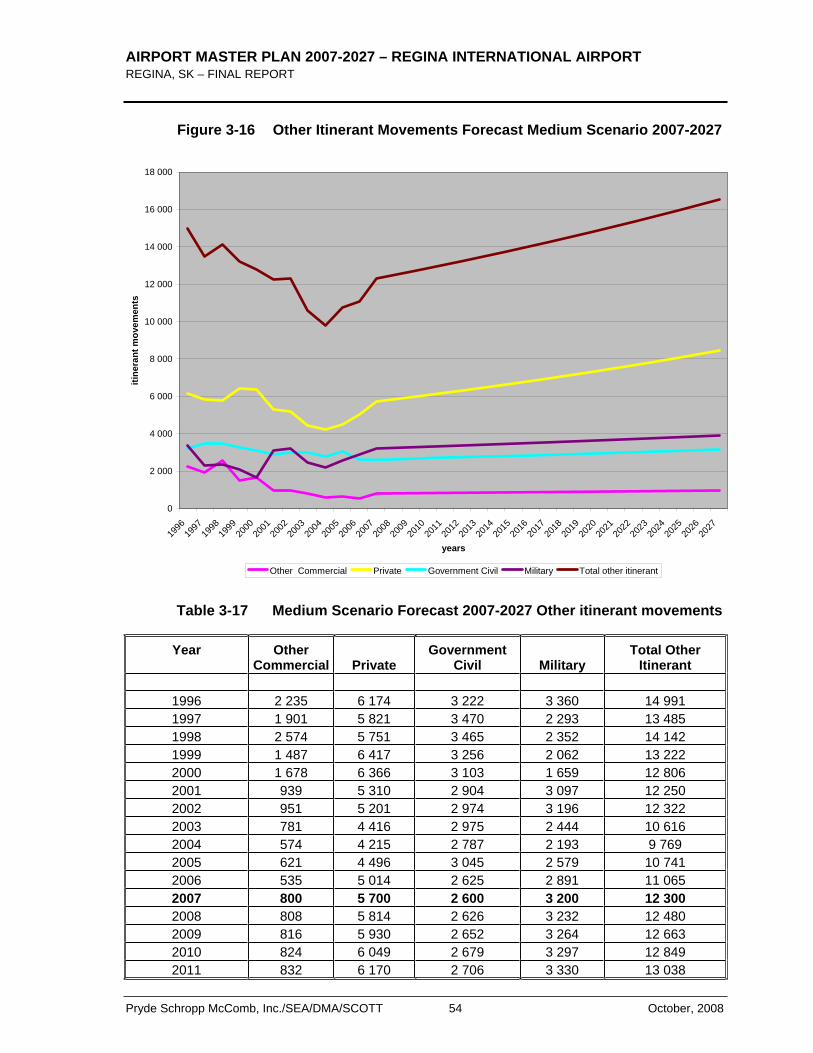
AIRPORT MASTER PLAN 2007-2027 – REGINA INTERNATIONAL AIRPORT REGINA, SK – FINAL REPORT
Pryde Schropp McComb, Inc./SEA/DMA/SCOTT 54 October, 2008
Figure 3-16 Other Itinerant Movements Forecast Medium Scenario 2007-2027
0
2 000
4 000
6 000
8 000
10 000
12 000
14 000
16 000
18 000
1996
1997
1998
1999
2000
2001
2002
2003
2004
2005
2006
2007
2008
2009
2010
2011
2012
2013
2014
2015
2016
2017
2018
2019
2020
2021
2022
2023
2024
2025
2026
2027
years
itine
rant
mov
emen
ts
Other Commercial Private Government Civil Military Total other itinerant
Table 3-17 Medium Scenario Forecast 2007-2027 Other itinerant movements
Year Other Commercial Private
Government Civil Military
Total Other Itinerant
1996 2 235 6 174 3 222 3 360 14 991 1997 1 901 5 821 3 470 2 293 13 485 1998 2 574 5 751 3 465 2 352 14 142 1999 1 487 6 417 3 256 2 062 13 222 2000 1 678 6 366 3 103 1 659 12 806 2001 939 5 310 2 904 3 097 12 250 2002 951 5 201 2 974 3 196 12 322 2003 781 4 416 2 975 2 444 10 616 2004 574 4 215 2 787 2 193 9 769 2005 621 4 496 3 045 2 579 10 741 2006 535 5 014 2 625 2 891 11 065 2007 800 5 700 2 600 3 200 12 300 2008 808 5 814 2 626 3 232 12 480 2009 816 5 930 2 652 3 264 12 663 2010 824 6 049 2 679 3 297 12 849 2011 832 6 170 2 706 3 330 13 038
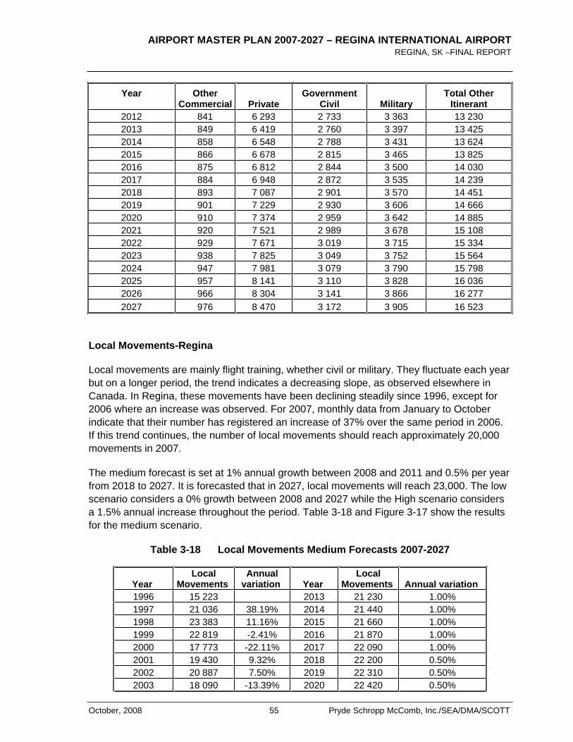
AIRPORT MASTER PLAN 2007-2027 – REGINA INTERNATIONAL AIRPORT REGINA, SK –FINAL REPORT
October, 2008 55 Pryde Schropp McComb, Inc./SEA/DMA/SCOTT
Year Other Commercial Private
Government Civil Military
Total Other Itinerant
2012 841 6 293 2 733 3 363 13 230 2013 849 6 419 2 760 3 397 13 425 2014 858 6 548 2 788 3 431 13 624 2015 866 6 678 2 815 3 465 13 825 2016 875 6 812 2 844 3 500 14 030 2017 884 6 948 2 872 3 535 14 239 2018 893 7 087 2 901 3 570 14 451 2019 901 7 229 2 930 3 606 14 666 2020 910 7 374 2 959 3 642 14 885 2021 920 7 521 2 989 3 678 15 108 2022 929 7 671 3 019 3 715 15 334 2023 938 7 825 3 049 3 752 15 564 2024 947 7 981 3 079 3 790 15 798 2025 957 8 141 3 110 3 828 16 036 2026 966 8 304 3 141 3 866 16 277 2027 976 8 470 3 172 3 905 16 523
Local Movements-Regina
Local movements are mainly flight training, whether civil or military. They fluctuate each year but on a longer period, the trend indicates a decreasing slope, as observed elsewhere in Canada. In Regina, these movements have been declining steadily since 1996, except for 2006 where an increase was observed. For 2007, monthly data from January to October indicate that their number has registered an increase of 37% over the same period in 2006. If this trend continues, the number of local movements should reach approximately 20,000 movements in 2007.
The medium forecast is set at 1% annual growth between 2008 and 2011 and 0.5% per year from 2018 to 2027. It is forecasted that in 2027, local movements will reach 23,000. The low scenario considers a 0% growth between 2008 and 2027 while the High scenario considers a 1.5% annual increase throughout the period. Table 3-18 and Figure 3-17 show the results for the medium scenario.
Table 3-18 Local Movements Medium Forecasts 2007-2027
YearLocal
Movements Annual
variation YearLocal
Movements Annual variation 1996 15 223 2013 21 230 1.00% 1997 21 036 38.19% 2014 21 440 1.00% 1998 23 383 11.16% 2015 21 660 1.00% 1999 22 819 -2.41% 2016 21 870 1.00% 2000 17 773 -22.11% 2017 22 090 1.00% 2001 19 430 9.32% 2018 22 200 0.50% 2002 20 887 7.50% 2019 22 310 0.50% 2003 18 090 -13.39% 2020 22 420 0.50%
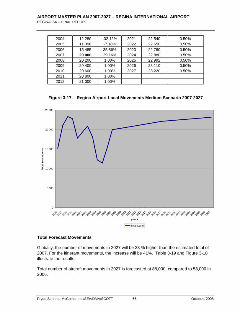
AIRPORT MASTER PLAN 2007-2027 – REGINA INTERNATIONAL AIRPORT REGINA, SK – FINAL REPORT
Pryde Schropp McComb, Inc./SEA/DMA/SCOTT 56 October, 2008
2004 12 280 -32.12% 2021 22 540 0.50% 2005 11 398 -7.18% 2022 22 650 0.50% 2006 15 485 35.86% 2023 22 760 0.50% 2007 20 000 29.16% 2024 22 880 0.50% 2008 20 200 1.00% 2025 22 992 0.50% 2009 20 400 1.00% 2026 23 110 0.50% 2010 20 600 1.00% 2027 23 220 0.50% 2011 20 800 1.00% 2012 21 000 1.00%
Figure 3-17 Regina Airport Local Movements Medium Scenario 2007-2027
0
5 000
10 000
15 000
20 000
25 000
1996
1997
1998
1999
2000
2001
2002
2003
2004
2005
2006
2007
2008
2009
2010
2011
2012
2013
2014
2015
2016
2017
2018
2019
2020
2021
2022
2023
2024
2025
2026
2027
years
loca
l mov
emen
ts
Total Local
Total Forecast Movements
Globally, the number of movements in 2027 will be 33 % higher than the estimated total of 2007. For the itinerant movements, the increase will be 41%. Table 3-19 and Figure 3-18 illustrate the results.
Total number of aircraft movements in 2027 is forecasted at 88,000, compared to 58,000 in 2006.
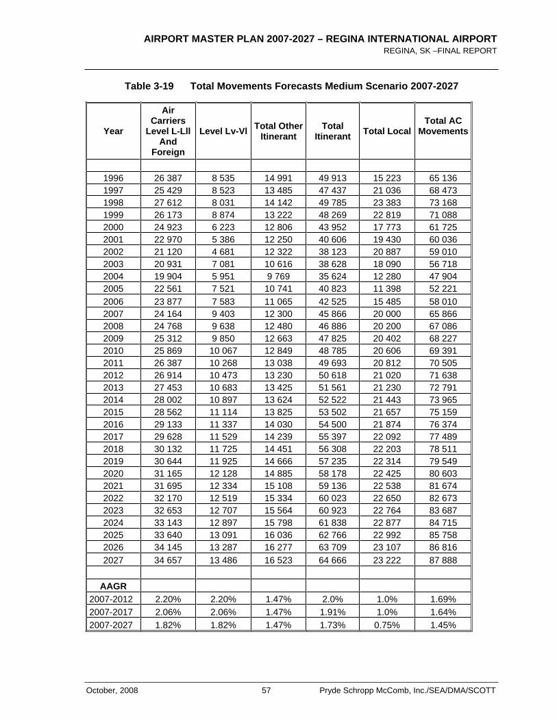
AIRPORT MASTER PLAN 2007-2027 – REGINA INTERNATIONAL AIRPORT REGINA, SK –FINAL REPORT
October, 2008 57 Pryde Schropp McComb, Inc./SEA/DMA/SCOTT
Table 3-19 Total Movements Forecasts Medium Scenario 2007-2027
Year
AirCarriers
Level L-Lll And
Foreign
Level Lv-Vl Total OtherItinerant
TotalItinerant Total Local
Total AC Movements
1996 26 387 8 535 14 991 49 913 15 223 65 136 1997 25 429 8 523 13 485 47 437 21 036 68 473 1998 27 612 8 031 14 142 49 785 23 383 73 168 1999 26 173 8 874 13 222 48 269 22 819 71 088 2000 24 923 6 223 12 806 43 952 17 773 61 725 2001 22 970 5 386 12 250 40 606 19 430 60 036 2002 21 120 4 681 12 322 38 123 20 887 59 010 2003 20 931 7 081 10 616 38 628 18 090 56 718 2004 19 904 5 951 9 769 35 624 12 280 47 904 2005 22 561 7 521 10 741 40 823 11 398 52 221 2006 23 877 7 583 11 065 42 525 15 485 58 010 2007 24 164 9 403 12 300 45 866 20 000 65 866 2008 24 768 9 638 12 480 46 886 20 200 67 086 2009 25 312 9 850 12 663 47 825 20 402 68 227 2010 25 869 10 067 12 849 48 785 20 606 69 391 2011 26 387 10 268 13 038 49 693 20 812 70 505 2012 26 914 10 473 13 230 50 618 21 020 71 638 2013 27 453 10 683 13 425 51 561 21 230 72 791 2014 28 002 10 897 13 624 52 522 21 443 73 965 2015 28 562 11 114 13 825 53 502 21 657 75 159 2016 29 133 11 337 14 030 54 500 21 874 76 374 2017 29 628 11 529 14 239 55 397 22 092 77 489 2018 30 132 11 725 14 451 56 308 22 203 78 511 2019 30 644 11 925 14 666 57 235 22 314 79 549 2020 31 165 12 128 14 885 58 178 22 425 80 603 2021 31 695 12 334 15 108 59 136 22 538 81 674 2022 32 170 12 519 15 334 60 023 22 650 82 673 2023 32 653 12 707 15 564 60 923 22 764 83 687 2024 33 143 12 897 15 798 61 838 22 877 84 715 2025 33 640 13 091 16 036 62 766 22 992 85 758 2026 34 145 13 287 16 277 63 709 23 107 86 816 2027 34 657 13 486 16 523 64 666 23 222 87 888
AAGR
2007-2012 2.20% 2.20% 1.47% 2.0% 1.0% 1.69% 2007-2017 2.06% 2.06% 1.47% 1.91% 1.0% 1.64% 2007-2027 1.82% 1.82% 1.47% 1.73% 0.75% 1.45%
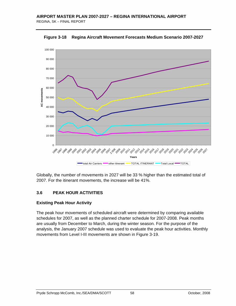
AIRPORT MASTER PLAN 2007-2027 – REGINA INTERNATIONAL AIRPORT REGINA, SK – FINAL REPORT
Pryde Schropp McComb, Inc./SEA/DMA/SCOTT 58 October, 2008
Figure 3-18 Regina Aircraft Movement Forecasts Medium Scenario 2007-2027
0
10 000
20 000
30 000
40 000
50 000
60 000
70 000
80 000
90 000
100 000
1996
1997
1998
1999
2000
2001
2002
2003
2004
2005
2006
2007
2 008
2009
2010
2011
2012
2013
2014
2015
2016
2017
2018
2019
2020
2021
2022
2023
2024
2025
2026
2027
Years
AC
mov
emen
ts
total Air Carriers other itinerant TOTAL ITINERANT Total Local TOTAL
Globally, the number of movements in 2027 will be 33 % higher than the estimated total of 2007. For the itinerant movements, the increase will be 41%.
3.6 PEAK HOUR ACTIVITIES
Existing Peak Hour Activity
The peak hour movements of scheduled aircraft were determined by comparing available schedules for 2007, as well as the planned charter schedule for 2007-2008. Peak months are usually from December to March, during the winter season. For the purpose of the analysis, the January 2007 schedule was used to evaluate the peak hour activities. Monthly movements from Level I-III movements are shown in Figure 3-19.
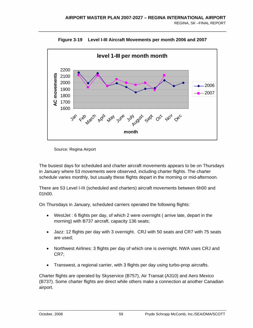
AIRPORT MASTER PLAN 2007-2027 – REGINA INTERNATIONAL AIRPORT REGINA, SK –FINAL REPORT
October, 2008 59 Pryde Schropp McComb, Inc./SEA/DMA/SCOTT
Figure 3-19 Level I-III Aircraft Movements per month 2006 and 2007
level 1-III per month month
1600170018001900200021002200
Jan
FebMarc
hApri
lMay
Ju
ne July
Augus
tSep
tOct Nov
Dec
month
AC m
ovem
ents
20062007
Source: Regina Airport
The busiest days for scheduled and charter aircraft movements appears to be on Thursdays in January where 53 movements were observed, including charter flights. The charter schedule varies monthly, but usually these flights depart in the morning or mid-afternoon.
There are 53 Level I-III (scheduled and charters) aircraft movements between 6h00 and 01h00.
On Thursdays in January, scheduled carriers operated the following flights:
WestJet : 6 flights per day, of which 2 were overnight ( arrive late, depart in the morning) with B737 aircraft, capacity 136 seats;
Jazz: 12 flights per day with 3 overnight. CRJ with 50 seats and CR7 with 75 seats are used;
Northwest Airlines: 3 flights per day of which one is overnight. NWA uses CRJ and CR7;
Transwest, a regional carrier, with 3 flights per day using turbo-prop aircrafts.
Charter flights are operated by Skyservice (B757), Air Transat (A310) and Aero Mexico (B737). Some charter flights are direct while others make a connection at another Canadian airport.
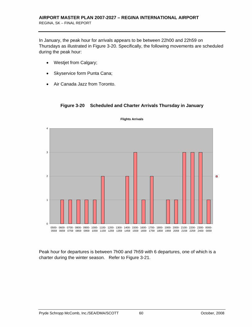
AIRPORT MASTER PLAN 2007-2027 – REGINA INTERNATIONAL AIRPORT REGINA, SK – FINAL REPORT
Pryde Schropp McComb, Inc./SEA/DMA/SCOTT 60 October, 2008
In January, the peak hour for arrivals appears to be between 22h00 and 22h59 on Thursdays as illustrated in Figure 3-20. Specifically, the following movements are scheduled during the peak hour:
Westjet from Calgary;
Skyservice form Punta Cana;
Air Canada Jazz from Toronto.
Figure 3-20 Scheduled and Charter Arrivals Thursday in January
Flights Arrivals
0
1
2
3
4
0500-0559
0600-0659
0700-0759
0800-0859
0900-0959
1000-1059
1100-1159
1200-1259
1300-1359
1400-1459
1500-1559
1600-1659
1700-1759
1800-1859
1900-1959
2000-2059
2100-2159
2200-2259
2300-2400
0000-0059
Peak hour for departures is between 7h00 and 7h59 with 6 departures, one of which is a charter during the winter season. Refer to Figure 3-21.
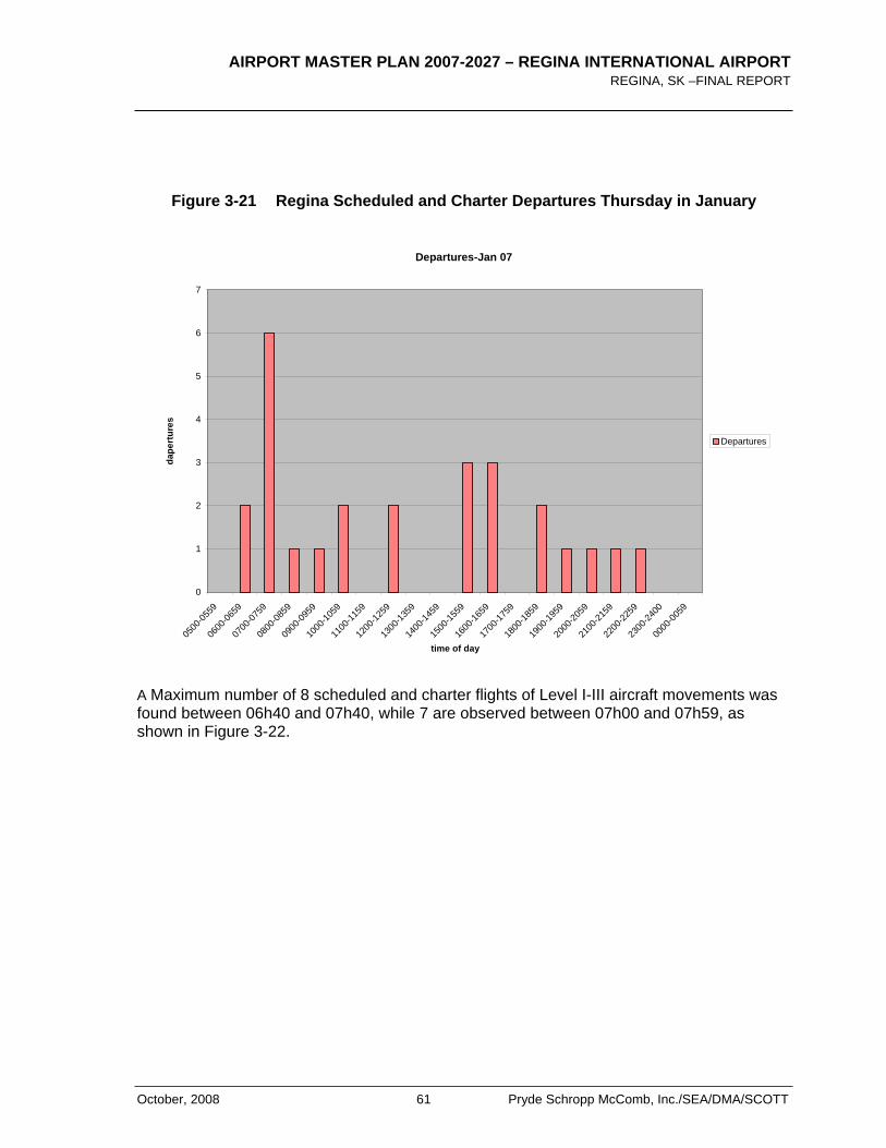
AIRPORT MASTER PLAN 2007-2027 – REGINA INTERNATIONAL AIRPORT REGINA, SK –FINAL REPORT
October, 2008 61 Pryde Schropp McComb, Inc./SEA/DMA/SCOTT
Figure 3-21 Regina Scheduled and Charter Departures Thursday in January
Departures-Jan 07
0
1
2
3
4
5
6
7
0500
-0559
0600
-0659
0700
-0759
0800
-0859
0900
-0959
1000
-1059
1100
-1159
1200
-1259
1300
-1359
1400
-1459
1500
-1559
1600
-1659
1700
-1759
1800
-1859
1900
-1959
2000
-2059
2100
-2159
2200
-2259
2300
-2400
0000
-0059
time of day
dape
rtur
es
Departures
A Maximum number of 8 scheduled and charter flights of Level I-III aircraft movements was found between 06h40 and 07h40, while 7 are observed between 07h00 and 07h59, as shown in Figure 3-22.
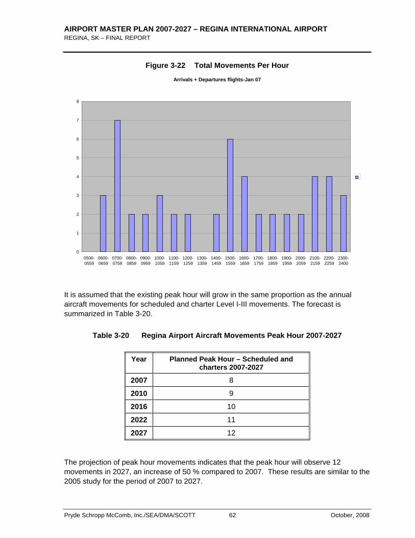
AIRPORT MASTER PLAN 2007-2027 – REGINA INTERNATIONAL AIRPORT REGINA, SK – FINAL REPORT
Pryde Schropp McComb, Inc./SEA/DMA/SCOTT 62 October, 2008
Figure 3-22 Total Movements Per Hour
Arrivals + Departures flights-Jan 07
0
1
2
3
4
5
6
7
8
0500-0559
0600-0659
0700-0759
0800-0859
0900-0959
1000-1059
1100-1159
1200-1259
1300-1359
1400-1459
1500-1559
1600-1659
1700-1759
1800-1859
1900-1959
2000-2059
2100-2159
2200-2259
2300-2400
It is assumed that the existing peak hour will grow in the same proportion as the annual aircraft movements for scheduled and charter Level I-III movements. The forecast is summarized in Table 3-20.
Table 3-20 Regina Airport Aircraft Movements Peak Hour 2007-2027
Year Planned Peak Hour – Scheduled and charters 2007-2027
2007 8
2010 9
2016 10
2022 11
2027 12
The projection of peak hour movements indicates that the peak hour will observe 12 movements in 2027, an increase of 50 % compared to 2007. These results are similar to the 2005 study for the period of 2007 to 2027.
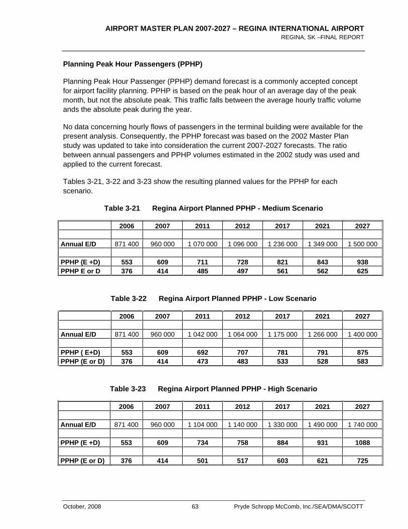
AIRPORT MASTER PLAN 2007-2027 – REGINA INTERNATIONAL AIRPORT REGINA, SK –FINAL REPORT
October, 2008 63 Pryde Schropp McComb, Inc./SEA/DMA/SCOTT
Planning Peak Hour Passengers (PPHP)
Planning Peak Hour Passenger (PPHP) demand forecast is a commonly accepted concept for airport facility planning. PPHP is based on the peak hour of an average day of the peak month, but not the absolute peak. This traffic falls between the average hourly traffic volume ands the absolute peak during the year.
No data concerning hourly flows of passengers in the terminal building were available for the present analysis. Consequently, the PPHP forecast was based on the 2002 Master Plan study was updated to take into consideration the current 2007-2027 forecasts. The ratio between annual passengers and PPHP volumes estimated in the 2002 study was used and applied to the current forecast.
Tables 3-21, 3-22 and 3-23 show the resulting planned values for the PPHP for each scenario.
Table 3-21 Regina Airport Planned PPHP - Medium Scenario
2006 2007 2011 2012 2017 2021 2027 Annual E/D 871 400 960 000 1 070 000 1 096 000 1 236 000 1 349 000 1 500 000
PPHP (E +D) 553 609 711 728 821 843 938 PPHP E or D 376 414 485 497 561 562 625
Table 3-22 Regina Airport Planned PPHP - Low Scenario
2006 2007 2011 2012 2017 2021 2027 Annual E/D 871 400 960 000 1 042 000 1 064 000 1 175 000 1 266 000 1 400 000
PPHP ( E+D) 553 609 692 707 781 791 875 PPHP (E or D) 376 414 473 483 533 528 583
Table 3-23 Regina Airport Planned PPHP - High Scenario
2006 2007 2011 2012 2017 2021 2027 Annual E/D 871 400 960 000 1 104 000 1 140 000 1 330 000 1 490 000 1 740 000
PPHP (E +D) 553 609 734 758 884 931 1088
PPHP (E or D) 376 414 501 517 603 621 725
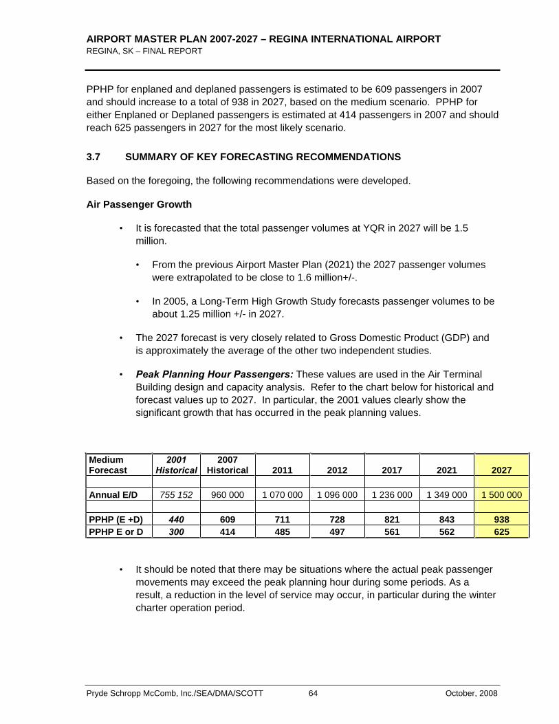
AIRPORT MASTER PLAN 2007-2027 – REGINA INTERNATIONAL AIRPORT REGINA, SK – FINAL REPORT
Pryde Schropp McComb, Inc./SEA/DMA/SCOTT 64 October, 2008
PPHP for enplaned and deplaned passengers is estimated to be 609 passengers in 2007 and should increase to a total of 938 in 2027, based on the medium scenario. PPHP for either Enplaned or Deplaned passengers is estimated at 414 passengers in 2007 and should reach 625 passengers in 2027 for the most likely scenario.
3.7 SUMMARY OF KEY FORECASTING RECOMMENDATIONS
Based on the foregoing, the following recommendations were developed.
Air Passenger Growth
• It is forecasted that the total passenger volumes at YQR in 2027 will be 1.5 million.
• From the previous Airport Master Plan (2021) the 2027 passenger volumes were extrapolated to be close to 1.6 million+/-.
• In 2005, a Long-Term High Growth Study forecasts passenger volumes to be about 1.25 million +/- in 2027.
• The 2027 forecast is very closely related to Gross Domestic Product (GDP) and is approximately the average of the other two independent studies.
• Peak Planning Hour Passengers: These values are used in the Air Terminal Building design and capacity analysis. Refer to the chart below for historical and forecast values up to 2027. In particular, the 2001 values clearly show the significant growth that has occurred in the peak planning values.
MediumForecast
2001Historical
2007Historical 2011 2012 2017 2021 2027
Annual E/D 755 152 960 000 1 070 000 1 096 000 1 236 000 1 349 000 1 500 000
PPHP (E +D) 440 609 711 728 821 843 938PPHP E or D 300 414 485 497 561 562 625
• It should be noted that there may be situations where the actual peak passenger movements may exceed the peak planning hour during some periods. As a result, a reduction in the level of service may occur, in particular during the winter charter operation period.
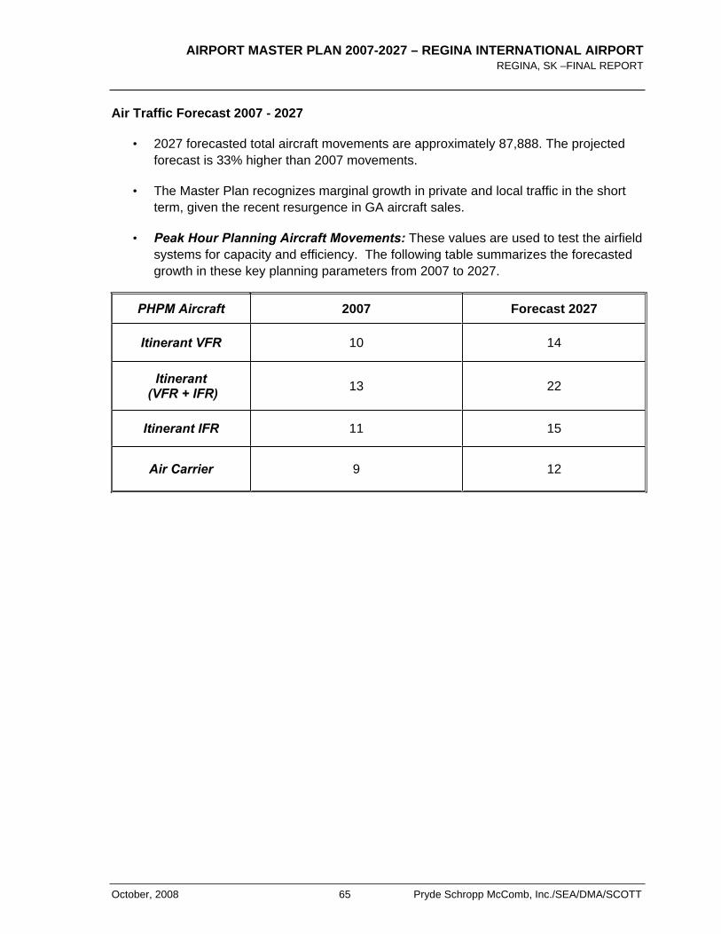
AIRPORT MASTER PLAN 2007-2027 – REGINA INTERNATIONAL AIRPORT REGINA, SK –FINAL REPORT
October, 2008 65 Pryde Schropp McComb, Inc./SEA/DMA/SCOTT
Air Traffic Forecast 2007 - 2027
• 2027 forecasted total aircraft movements are approximately 87,888. The projected forecast is 33% higher than 2007 movements.
• The Master Plan recognizes marginal growth in private and local traffic in the short term, given the recent resurgence in GA aircraft sales.
• Peak Hour Planning Aircraft Movements: These values are used to test the airfield systems for capacity and efficiency. The following table summarizes the forecasted growth in these key planning parameters from 2007 to 2027.
PHPM Aircraft 2007 Forecast 2027
Itinerant VFR 10 14
Itinerant (VFR + IFR) 13 22
Itinerant IFR 11 15
Air Carrier 9 12

AIRPORT MASTER PLAN 2007-2027 – REGINA INTERNATIONAL AIRPORT REGINA, SK – FINAL REPORT
Pryde Schropp McComb, Inc./SEA/DMA/SCOTT 66 October, 2008
< THIS PAGE LEFT INTENTIONALLY BLANK >
AIRPORT MASTER PLAN 2007-2027 – REGINA INTERNATIONAL AIRPORT REGINA, SK –FINAL REPORT
October, 2008 67 Pryde Schropp McComb, Inc./SEA/DMA/SCOTT
4.0 Constraints & Opportunities (Airside and Groundside)
Of primary concern to the Regina Airport Authority is the safe and efficient operation of aircraft and the associated services including passenger processing, cargo, charter services etc. To this end, the master planning process identified and quantified key factors to ensure the protection and expandability of the existing airside systems. Factors considered included airfield safety, obstacle limitation surfaces, electronic zoning, air traffic services and other related aeronautical protection measures. Considering these factors, a layering of constraints was developed to understand the potential for supplemental development opportunities at the airport. As such, areas were identified that ranged from “nodevelopment allowed”, to “some development (provided it adhered to strict guidelines)”, to “development-friendly areas with few restrictions”. These areas were classified using the letters “A” through “I”. In general, Areas A, B, C, D, and F, offer no development, to very little development opportunity. Area G represents existing commercial/industrial development. Areas H and I are the areas with the fewest limits on development and as such offer the greatest opportunity for groundside expansion. Area E offers some opportunity for groundside commercial expansion with some restriction on building heights, configuration, and use.
Exhibit 6 presents our broad-based analysis which was used as a guideline in understanding the most practical and efficient development areas and concepts for the Airport Master Plan.

AIRPORT MASTER PLAN 2007-2027 – REGINA INTERNATIONAL AIRPORT REGINA, SK – FINAL REPORT
Pryde Schropp McComb, Inc./SEA/DMA/SCOTT 68 October, 2008
< THIS PAGE LEFT INTENTIONALLY BLANK >
AIRPORT MASTER PLAN 2007-2027 – REGINA INTERNATIONAL AIRPORT REGINA, SK –FINAL REPORT
October, 2008 69 Pryde Schropp McComb, Inc./SEA/DMA/SCOTT
5.0 Airfield Analysis
5.1 GENERAL
Airside infrastructure includes all runways, taxiways and apron surfaces at an airport as well as approach lighting and navigational aids required for airside operations. Exhibit 1 shows the layout of the airfield at YQR. The Airport elevation is 1,894 feet Above Sea Level and the Airport Reference Temperature for planning purposes is 25oC.
The airside system is the Airport's most fundamental operating system. This includes all manoeuvring surfaces, together with the facilities and services required to support aircraft operations, including runways, taxiways, aprons and navigation and approach aids. The capabilities, capacity and usability of the airside system under a wide range of conditions must be consistent with the operating requirements of the air carrier markets the Airport serves or seeks to serve. However, airside infrastructure is expensive to build and maintain, and excess, unused capacity can represent a cost burden on operations.
Airfield requirements are established by comparing forecast activity to the existing facility capacity over the 20-year planning horizon. This assessment takes into consideration the anticipated activity levels suggested by the aviation forecasts, together with estimates of the type of aircraft and the mix of traffic using the Airport in the future.
An assessment of the Airport’s “usability” is undertaken to confirm the capability of the airside system to support operations under the range of annual wind and weather variations. Usability values below 95% indicate the need for improvements in runway wind coverage and instrument approach capability.
The airside analysis compares hourly and annual forecasts to the estimated capacity of the airfield system taking into consideration the expected aircraft mix in terms of size and operating characteristics. Annual movement forecasts provide abroad indication of capacity needs, with the Planning Peak Hour forecasts supplying a finer analysis of demand characteristics. In addition, the supporting taxiway and apron systems were also reviewed for adequacy.
5.2 GUIDING PRINCIPLES
Airside system planning for YQR is structured by the RAA’s strategic objectives and is specifically undertaken in accordance with the following principles and assumptions:
Safety and security are the first priority;
Provide access for commercial operations 24 hours a day;
Control the environmental impacts of operation by “designing-in” mitigation as necessary;
AIRPORT MASTER PLAN 2007-2027 – REGINA INTERNATIONAL AIRPORT REGINA, SK – FINAL REPORT
Pryde Schropp McComb, Inc./SEA/DMA/SCOTT 70 October, 2008
Match capacity to demand by maximizing the existing plant and applying technology to enhance productivity;
Preserve land necessary to provide new capacity when justified by demand;
Optimize airfield operating efficiency and costs.
Planning Standards. Conduct all YQR planning in accordance with Transport Canada and applicable international standards.
Planning Aircraft. The Airport Operations Manual identifies the Critical Aircraft as the Airbus A320. For the purposes of this Master Plan, however, Code D aircraft standards have been applied to the airfield and Air Terminal Building complex to ensure compatibility with aircraft in the Boeing B-767/Airbus A330 category which are typically used by charter operators and possible future cargo operations.
5.3 CURRENT AIRFIELD FACILITIES
The following has been based on a general review of the existing airfield facilities at YQR. Appendix B contains more detailed technical summaries for all the facilities.
Runways
YQR’s airfield has two intersecting runways. The alignment of the runways reflects the prevailing wind directions and both runways were originally part of the triangular runway configuration developed during World War II. The runways were narrowed from 60m (200’) to 45m (150’) in width to reduce operating costs (Runway 08-26 in 1989, and Runway 13-31 in 1992). The runways meet ICAO Code D standards and are suitable for operations by aircraft in the B-767 category. The physical characteristics of the runways are described in greater detail in Appendix B.
Aprons and Taxiways
The taxiway system at YQR is made up of eight designated taxiways, A, B, B1, C, K, M, N and P. There are four aprons available for public use. Apron I and II are the primary aprons located adjacent to the Air Terminal Building.
Refer to Appendix B for additional details related to these facilities.
Airfield Lighting and Visual Approach Aids
The airfield is fully equipped to support night operations. The major lighting components are:
Runway 13-31: Runway 13 is equipped with High Intensity Edge lights and a High Intensity Precision Approach Light System. Runway 31 has standard non-precision Omni Directional Approach Lighting System (ODALS). Runway 31 is also equipped with a Visual Approach Slope Indicator System (VASIS). Transport Canada
AIRPORT MASTER PLAN 2007-2027 – REGINA INTERNATIONAL AIRPORT REGINA, SK –FINAL REPORT
October, 2008 71 Pryde Schropp McComb, Inc./SEA/DMA/SCOTT
guidelines intend for the replacement of VASIS by the Precision Approach Path Indicator system. Both runway end windsocks are lighted.
Runway 08-26: The runway is equipped with High Intensity Edge lights. Both runway ends have ODALS approach lighting and are VASIS equipped. Both windsocks are lighted.
Refer to Appendix B for additional details related to these facilities.
Approach and Landing Aids
Navigational guidance for aircraft operating in the Regina Terminal Area is provided by four Non Directional Beacons (NDB) and a VHF Omni Range (VOR). The VOR, located at Lumsden, some 16nm from the airport, does not provide an instrument approach capability. Air traffic control radar augments the VOR by providing directional guidance to arriving and departing aircraft.
The four NDBs provide non-precision approaches for each of the four runways. An Instrument Landing System (ILS) on Runway 13 provides precision approach guidance, with the remaining approaches being non-precision.
Refer to Appendix B for additional details related to these facilities.
5.4 AIRPORT USABILITY
The previous 2001-2021 Airport Master Plan concluded that the combination of the two (2) runways exceeds the Transport Canada recommended usability of 95%. As such, there is no requirement to improve the airport usability by adding additional runways or re-aligning existing ones. Table 5-1 below demonstrates the various runway usability factors for different combinations of runways and weather conditions.
While the secondary Runway 08-26 is not used a significant amount by the main commercial air carriers (only about 10-12% of the time by all aircraft), it still serves an important role in supporting safe operations of the smaller general aviation community and the main air carriers under certain wind conditions.
Figures 5-1 and 5-2 show the actual runway use distribution confirming the relative usage of Runway 08-26 with respect to the primary Runway 13-31.
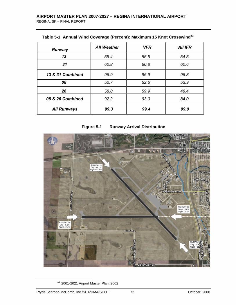
AIRPORT MASTER PLAN 2007-2027 – REGINA INTERNATIONAL AIRPORT REGINA, SK – FINAL REPORT
Pryde Schropp McComb, Inc./SEA/DMA/SCOTT 72 October, 2008
Table 5-1 Annual Wind Coverage (Percent): Maximum 15 Knot Crosswind13
Runway All Weather VFR All IFR
13 55.4 55.5 54.5
31 60.8 60.8 60.6
13 & 31 Combined 96.9 96.9 96.8
08 52.7 52.6 53.9
26 58.8 59.9 48.4
08 & 26 Combined 92.2 93.0 84.0
All Runways 99.3 99.4 99.0
Figure 5-1 Runway Arrival Distribution
13 2001-2021 Airport Master Plan, 2002
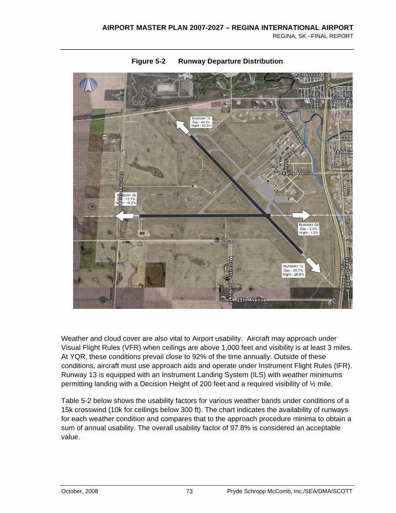
AIRPORT MASTER PLAN 2007-2027 – REGINA INTERNATIONAL AIRPORT REGINA, SK –FINAL REPORT
October, 2008 73 Pryde Schropp McComb, Inc./SEA/DMA/SCOTT
Figure 5-2 Runway Departure Distribution
Weather and cloud cover are also vital to Airport usability. Aircraft may approach under Visual Flight Rules (VFR) when ceilings are above 1,000 feet and visibility is at least 3 miles. At YQR, these conditions prevail close to 92% of the time annually. Outside of these conditions, aircraft must use approach aids and operate under Instrument Flight Rules (IFR). Runway 13 is equipped with an Instrument Landing System (ILS) with weather minimums permitting landing with a Decision Height of 200 feet and a required visibility of ½ mile.
Table 5-2 below shows the usability factors for various weather bands under conditions of a 15k crosswind (10k for ceilings below 300 ft). The chart indicates the availability of runways for each weather condition and compares that to the approach procedure minima to obtain a sum of annual usability. The overall usability factor of 97.8% is considered an acceptable value.
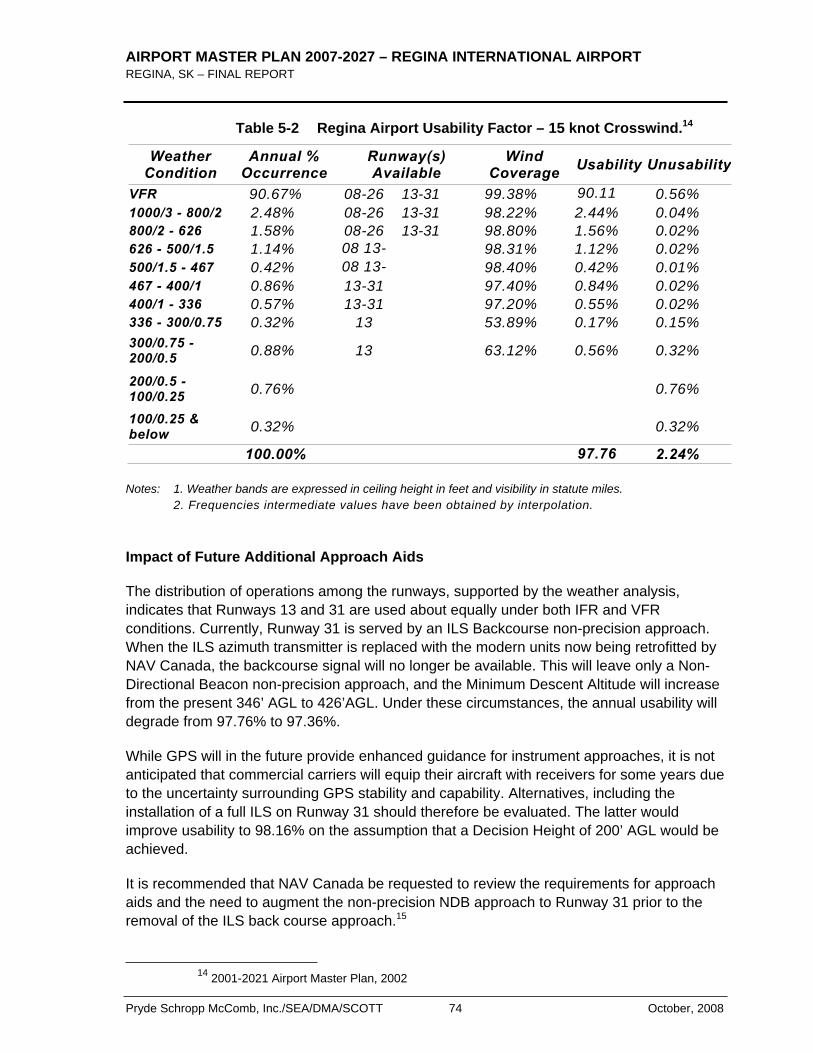
AIRPORT MASTER PLAN 2007-2027 – REGINA INTERNATIONAL AIRPORT REGINA, SK – FINAL REPORT
Pryde Schropp McComb, Inc./SEA/DMA/SCOTT 74 October, 2008
Table 5-2 Regina Airport Usability Factor – 15 knot Crosswind.14
Weather Condition
Annual % Occurrence
Runway(s) Available
WindCoverage Usability Unusability
VFR 90.67% 08-26 13-31 99.38% 90.11 0.56% 1000/3 - 800/2 2.48% 08-26 13-31 98.22% 2.44% 0.04% 800/2 - 626 1.58% 08-26 13-31 98.80% 1.56% 0.02% 626 - 500/1.5 1.14% 08 13- 98.31% 1.12% 0.02% 500/1.5 - 467 0.42% 08 13- 98.40% 0.42% 0.01% 467 - 400/1 0.86% 13-31 97.40% 0.84% 0.02% 400/1 - 336 0.57% 13-31 97.20% 0.55% 0.02% 336 - 300/0.75 0.32% 13 53.89% 0.17% 0.15% 300/0.75 - 200/0.5 0.88% 13 63.12% 0.56% 0.32%
200/0.5 - 100/0.25 0.76% 0.76%
100/0.25 & below 0.32% 0.32%
100.00% 97.76 2.24%
Notes: 1. Weather bands are expressed in ceiling height in feet and visibility in statute miles. 2. Frequencies intermediate values have been obtained by interpolation.
Impact of Future Additional Approach Aids
The distribution of operations among the runways, supported by the weather analysis, indicates that Runways 13 and 31 are used about equally under both IFR and VFR conditions. Currently, Runway 31 is served by an ILS Backcourse non-precision approach. When the ILS azimuth transmitter is replaced with the modern units now being retrofitted by NAV Canada, the backcourse signal will no longer be available. This will leave only a Non-Directional Beacon non-precision approach, and the Minimum Descent Altitude will increase from the present 346’ AGL to 426’AGL. Under these circumstances, the annual usability will degrade from 97.76% to 97.36%.
While GPS will in the future provide enhanced guidance for instrument approaches, it is not anticipated that commercial carriers will equip their aircraft with receivers for some years due to the uncertainty surrounding GPS stability and capability. Alternatives, including the installation of a full ILS on Runway 31 should therefore be evaluated. The latter would improve usability to 98.16% on the assumption that a Decision Height of 200’ AGL would be achieved.
It is recommended that NAV Canada be requested to review the requirements for approach aids and the need to augment the non-precision NDB approach to Runway 31 prior to the removal of the ILS back course approach.15
14 2001-2021 Airport Master Plan, 2002
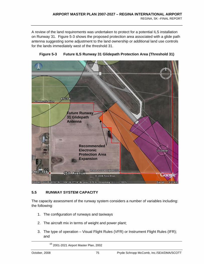
AIRPORT MASTER PLAN 2007-2027 – REGINA INTERNATIONAL AIRPORT REGINA, SK –FINAL REPORT
October, 2008 75 Pryde Schropp McComb, Inc./SEA/DMA/SCOTT
A review of the land requirements was undertaken to protect for a potential ILS installation on Runway 31. Figure 5-3 shows the proposed protection area associated with a glide path antenna suggesting some adjustment to the land ownership or additional land use controls for the lands immediately west of the threshold 31.
Figure 5-3 Future ILS Runway 31 Glidepath Protection Area (Threshold 31)
5.5 RUNWAY SYSTEM CAPACITY
The capacity assessment of the runway system considers a number of variables including: the following:
1. The configuration of runways and taxiways
2. The aircraft mix in terms of weight and power plant;
3. The type of operation – Visual Flight Rules (VFR) or Instrument Flight Rules (IFR); and
15 2001-2021 Airport Master Plan, 2002
Future Runway 31 Glidepath Antenna
RecommendedElectronicProtection Area Expansion
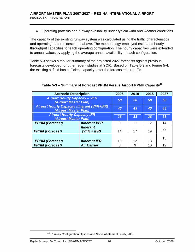
AIRPORT MASTER PLAN 2007-2027 – REGINA INTERNATIONAL AIRPORT REGINA, SK – FINAL REPORT
Pryde Schropp McComb, Inc./SEA/DMA/SCOTT 76 October, 2008
4. Operating patterns and runway availability under typical wind and weather conditions.
The capacity of the existing runway system was calculated using the traffic characteristics and operating patterns described above. The methodology employed estimated hourly throughput capacities for each operating configuration. The hourly capacities were extended to annual values by applying the average annual availability of each configuration.
Table 5-3 shows a tabular summary of the projected 2027 forecasts against previous forecasts developed for other recent studies at YQR. Based on Table 5-3 and Figure 5-4, the existing airfield has sufficient capacity to for the forecasted air traffic.
Table 5-3 – Summary of Forecast PPHM Versus Airport PPMH Capacity16
Scenario Description 2005 2010 2015 2027Airport Hourly Capacity – VFR
(Airport Master Plan) 50 50 50 50
Airport Hourly Capacity Itinerant (VFR+IFR) (Airport Master Plan) 43 43 43 43
Airport Hourly Capacity IFR (Airport Master Plan) 38 38 38 38
PPHM (Forecast) Itinerant VFR 9 11 12 14
PPHM (Forecast) Itinerant (VFR + IFR) 14 17 19 22
PPHM (Forecast) Itinerant IFR 10 12 13 15
PPHM (Forecast) Air Carrier 8 9 10 12
16 Runway Configuration Options and Noise Abatement Study, 2005
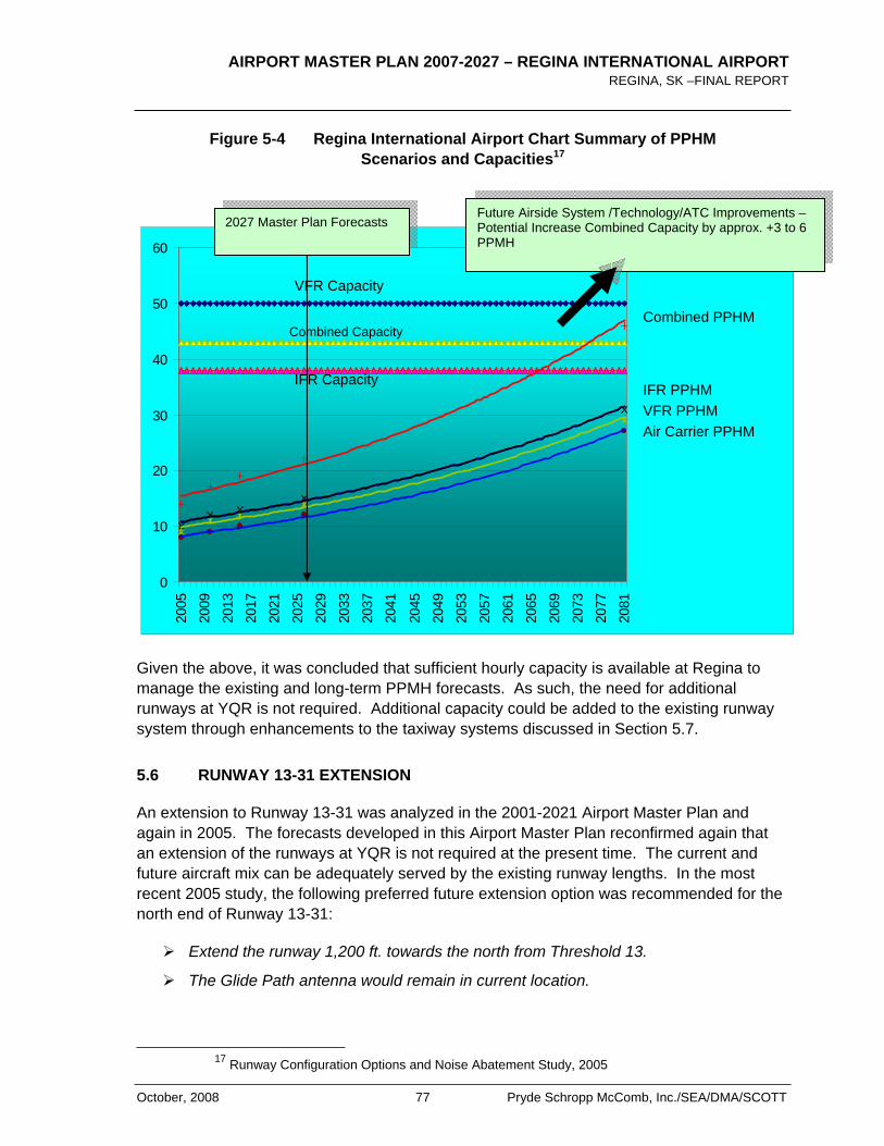
AIRPORT MASTER PLAN 2007-2027 – REGINA INTERNATIONAL AIRPORT REGINA, SK –FINAL REPORT
October, 2008 77 Pryde Schropp McComb, Inc./SEA/DMA/SCOTT
Figure 5-4 Regina International Airport Chart Summary of PPHM Scenarios and Capacities17
0
10
20
30
40
50
60
2005
2009
2013
2017
2021
2025
2029
2033
2037
2041
2045
2049
2053
2057
2061
2065
2069
2073
2077
2081
Given the above, it was concluded that sufficient hourly capacity is available at Regina to manage the existing and long-term PPMH forecasts. As such, the need for additional runways at YQR is not required. Additional capacity could be added to the existing runway system through enhancements to the taxiway systems discussed in Section 5.7.
5.6 RUNWAY 13-31 EXTENSION
An extension to Runway 13-31 was analyzed in the 2001-2021 Airport Master Plan and again in 2005. The forecasts developed in this Airport Master Plan reconfirmed again that an extension of the runways at YQR is not required at the present time. The current and future aircraft mix can be adequately served by the existing runway lengths. In the most recent 2005 study, the following preferred future extension option was recommended for the north end of Runway 13-31:
Extend the runway 1,200 ft. towards the north from Threshold 13.
The Glide Path antenna would remain in current location.
17 Runway Configuration Options and Noise Abatement Study, 2005
VFR Capacity
Combined Capacity
IFR Capacity
Air Carrier PPHMVFR PPHM IFR PPHM
Combined PPHM
Future Airside System /Technology/ATC Improvements – Potential Increase Combined Capacity by approx. +3 to 6 PPMH
2027 Master Plan Forecasts
AIRPORT MASTER PLAN 2007-2027 – REGINA INTERNATIONAL AIRPORT REGINA, SK – FINAL REPORT
Pryde Schropp McComb, Inc./SEA/DMA/SCOTT 78 October, 2008
Displaced threshold (1,200 ft.) to achieve 9,100 ft. total length – subject to further study.
Approach lighting would be partially inset into the pavement.
Existing Airport Zoning Regulations would protect for this configuration and would not need to be updated in the short-term.
No change to physical infrastructure beyond airport property. Existing approach lighting can be re-used with only minor adjustments.
This extension is conceptual in nature and would only be considered subject to further technical evaluation and would only be considered given appropriate economic justification.
Since this report was published, regulatory changes are anticipated that may require additional protection off the ends of runways referred to as Runway End Safety Areas (RESA). To this end, this master plan confirmed that in order to comply with this anticipated regulation, the maximum extension possible would be 1,100 ft. rather than the 1,200 ft. extension evaluated in 2005. This extension would result in a total runway length for Runway 13-31 of 9,000 ft. The extension concept is shown in Exhibit 7 and should be protected for long-term flexibility.
5.7 TAXIWAY AND APRON SYSTEMS
Based on the runway capacity analysis above, the existing runway/taxiway system is satisfactory for the projected aircraft volumes. Some minor fillet improvements are recommended at the existing taxiway connections along Runway 13-31 based on the findings of the 2001-2021 Airport Master Plan. These are not required in the short-term but should be programmed when work is planned in these areas and it is cost-effective to do so. These improvements are shown on Exhibit 7.
Furthermore, Taxiway B1 was assessed to determine if it should remain within the taxiway system. The analysis confirmed that it should be retained as it provides an early exit point for aircraft landing on Runway 31. Removing this taxiway would increase taxi times by about 1.5 minutes on the runway. Furthermore, the reduced taxi time results in less fuel usage. This taxiway is also very closely located at a future “high speed” rapid exit taxiway (RET) point which confirms its location as being suitable as an exit point.
High speed or Rapid Exit Taxiway (RETs) are not required within the planning period however, they have been shown on Exhibit 7 to ensure long-term protection. In addition, a parallel taxiway system for Runway 08-26 is not required in the planning period but has been highlighted in Exhibit 7 for long-term protection.
In general, Aprons I and II are constrained by groundside development on the east side and airside protection areas on the west side. As such the aprons cannot be expanded any further towards the west, east or south.
AIRPORT MASTER PLAN 2007-2027 – REGINA INTERNATIONAL AIRPORT REGINA, SK –FINAL REPORT
October, 2008 79 Pryde Schropp McComb, Inc./SEA/DMA/SCOTT
Apron II is also impacted by Obstacle Limitation Surfaces from Runway 08-26 which restrict the height of aircraft parked on its surface. Apron II also has pavement loading restrictions which limits its use for parking. Appendix D shows the related constraints on these aprons. Aprons III and IV provide adequate manoeuvring area for their intended use.
The most suitable expansion route for Apron I is towards the north and eventually bending towards the northeast as shown in Exhibit 7. The interface between Aprons I and II should be improved with some pavement infilling to allow more efficient parking of aircraft close to the Air Terminal Building and to support future bridge connections. Along with these infills, the overall pavement structure should be re-evaluated to increase its strength to match that of Apron I ensuring maximum flexibility of use. Apron II will also play an important role in managing the interim aircraft parking peaks while the expansion to Apron I is planned.
The long-term plan includes provisions of a remote aircraft parking apron as shown in Exhibit 7 which would be developed as Apron I continues to expand towards the north.
5.8 SUMMARY OF KEY RECOMMENDATIONS
Based on the foregoing, the following recommendations were developed. Exhibit 7 shows the various airside enhancements presented below:
1. Runway 13-31
• The Airport Master Plan reserves land on north end of Runway 13-31 for a future extension to the north giving an ultimate runway length capability of 9,000 ft.
• Continue to protect for a CAT I precision approach for both ends of Runway 13-31.
2. Runway 08-26:
• No changes are proposed.
• Continue to protect for precision approaches in accordance with the existing AZR.
3. Protect both runways for parallel taxiway systems although a parallel taxiway is not required within the planning period for Runway 08-26.
4. The taxiway system could be improved to increase overall capacity of the airfield with enhancements including:
• Taxiway fillets (medium-term and most likely sufficient within planning period).
• High speed Rapid Exit Taxiways (RETs) on Runway 13-31 (beyond the planning period as forecast traffic volumes do not support them).

AIRPORT MASTER PLAN 2007-2027 – REGINA INTERNATIONAL AIRPORT REGINA, SK – FINAL REPORT
Pryde Schropp McComb, Inc./SEA/DMA/SCOTT 80 October, 2008
• Very long-term parallel taxiway Runway 08-26 (beyond the planning period)
• Existing holding bay would be reasonable alternative within planning period as traffic warrants. It is currently used by maintenance equipment for holding only and is closed to air traffic.
5. Taxiway B1 should be retained.
6. Apron I – Systematic Expansion to the North for ATB Expansion and Remote Parking/De-Icing
7. Apron II – Retain for GA Traffic requiring minor interface enhancements to permit high tire pressure loads. Apron II could also act as an interim remote parking area and for ground service equipment (GSE). Parking arrangements need to be planned to ensure aircraft tail heights do not conflict with the runway systems.
8. Aprons III and IV – Retain and improve as airside commercial development matures.
9. Retain and protect the Runway 13 ILS system.
10. Recommend an ILS for Runway 31 or equivalent GPS Precision Approach.
• Would improve efficiency of approaches and reduce overall airport noise footprint.
• Land protected for CAT I approach lighting Runway 31 to supplement proposed CAT I ILS.
• Recommend protecting some lands adjacent to the airport as shown in Exhibit 7 for provision of a future ILS on Runway 31.
11. Continue to protect for future precision approaches on Runway 08-26
12. Investigate options to amend the existing Federal Airport Zoning Regulations to include Electronic Zoning.
AIRPORT MASTER PLAN 2007-2027 – REGINA INTERNATIONAL AIRPORT REGINA, SK –FINAL REPORT
October, 2008 81 Pryde Schropp McComb, Inc./SEA/DMA/SCOTT
6.0 Air Terminal Building Complex
6.1 SUMMARY OF ANALYSIS
Constructed in 1960, the current ATB underwent a major expansion and renovation in 1984/86. During those years, YQR was serving roughly 600,000 passengers a year. In 2001, the ATB accommodated about 25% more traffic, at a total of 755,000 passengers. In 2005 a major ATB renovation was completed in response to the findings the 2001-2021 Airport Master Plan. Passenger traffic is forecast to reach over 1.5 million by the end of the planning horizon in 2027 based on the forecasts of this Airport Master Plan.
It is expected that the passenger facilities will require expansion to meet demand through the planning period. The following section presents the results of the requirements analysis and the terminal expansion options to meet the demand. While expansion is required, it was further confirmed that the existing building can be efficiently expanded within and around its current core. As such, an entirely new Air Terminal Building would not be required. Also, it has been demonstrated below that expansion can take place in a phased manner.
The following is intended to capture the key observations, recommendations and a logical phasing program. Exhibits 8 through 11 apply to this section. These Exhibits include references to various AREAs which are highlighted throughout the following sections. For a more detailed review of the Air Terminal Building analysis, refer to Appendix C.
6.2 MASTER PLAN CONCEPT 2027 RECOMMENDATIONS
The following is intended to capture the main recommendations for the master planning period:
1. Relocate existing administration offices to a new terminal extension in the south quadrant – AREA A (Exhibit 8).
2. Expand immigration operations in northwest quadrant – AREA B (Exhibit 8).
3. Expand baggage make-up and breakdown rooms by expansion towards ramp – AREA C (Exhibit 8).
4. Reconfigure check-in operation in order to maximize self check-in, baggage drop and kiosk use – AREA D (Exhibit 8).
5. Realign frontage of terminal by 9 metres by reconfiguring approach road and parking – AREA E (Exhibit 8).
6. The development of the first floor south structure to accommodate the relocated Administration offices permits development of a new consolidated restroom facility at
AIRPORT MASTER PLAN 2007-2027 – REGINA INTERNATIONAL AIRPORT REGINA, SK – FINAL REPORT
Pryde Schropp McComb, Inc./SEA/DMA/SCOTT 82 October, 2008
the south end of the hold area. This then permits a consolidation of the hold area into a contiguous zone - AREA F (Exhibit 9).
7. Based on the existing forecast gating requirements, at least 8 gates should be planned for within the master planning period. Currently there are 5 operational gates with plans to expand to 6.
6.3 MASTER PLAN CONCEPT 2027 RECOMMENDED PHASING
While the above shows the ultimate development footprint for the Air Terminal Building to the end of the planning period i.e. 2027, the following suggests a logical phasing strategy to better manage the capital investment and to address the winter time “peaking” events which currently reduces the level of service due to reaching capacity of some of the facilities in key areas including check-in. Refer also to Exhibits 10 and 11:
Phase 1 (Immediate 1-2 years):
1. Realign road way and approach road to accommodate the 9 metre widening of the Air Terminal Building front.
2. Construct new front bay and canopy to terminal and commission new airline and rental facilities on the ground floor.
3. On the second floor the additional area provided by the two storey frontage bay can be utilized as additional queue area for the existing PBS facility and well wishers lounge.
4. At the completion of Phase 1, the current restrictive check-in queue depth and lack of first floor Groundside retailing will have been alleviated.
Phase 2 (Short-term 2-5 years):
1. Construct new south quadrant and reconfigure existing Administration Offices.
2. Construct new escalator/stair unit that retains the existing start point on the ground floor but switches direction at a mezzanine to allow people exiting the stairs to flow in the direction of the pre-boarding screening area.
3. Demolish the existing elevator to open up more space for retail on the ground floor and relocate them adjacent to the escalators.
4. Reconfigure check-in counters and back belt.
5. Construct new expanded PBS facility at second floor.
6. Construct new hold room restrooms, decommission existing restrooms.

AIRPORT MASTER PLAN 2007-2027 – REGINA INTERNATIONAL AIRPORT REGINA, SK –FINAL REPORT
October, 2008 83 Pryde Schropp McComb, Inc./SEA/DMA/SCOTT
7. Construct new airside retail and Air Canada Lounge and decommission existing hold room retail.
8. Consolidate hold room.
Note: Phases 1 and 2 should ideally occur concurrently in order to address existing operational constraints.
Phase 3 (Medium-term 5-10 years):
1. Based on meeting target growth forecasts, construct expanded bag make-up room.
2. Install new make-up device and connect to modified hold bag storage operation.
Phase 4 (Long-term 10 years):
1. Based on projected international traffic, construct new north quadrant.
2. Install new international bag claim carousel and feed belt.
3. Construct new escalator/stair/elevator node and new PIL.
4. Expand Canada Border Services Agency (CBSA) secondary operations to meet projected inbound international and transborder operations
5. Install additional passenger boarding bridges.
As required:
1. Install additional bridge position at south and north quadrant.

AIRPORT MASTER PLAN 2007-2027 – REGINA INTERNATIONAL AIRPORT REGINA, SK – FINAL REPORT
Pryde Schropp McComb, Inc./SEA/DMA/SCOTT 84 October, 2008
< THIS PAGE LEFT INTENTIONALLY BLANK >
AIRPORT MASTER PLAN 2007-2027 – REGINA INTERNATIONAL AIRPORT REGINA, SK –FINAL REPORT
October, 2008 85 Pryde Schropp McComb, Inc./SEA/DMA/SCOTT
7.0 Air Cargo
7.1 GENERAL
An Air Cargo Market Study completed in 2001 for YQR highlighted the potential of cargo development. However, the realization of such potential depends upon the pricing of future air cargo services at YQR, Saskatchewan penetration of new markets through aggressive marketing and economic development strategies, and success in increasing diversion from other modes of transport. Conditions at YQR have not changed substantially enough to change the conclusions of this report. Nonetheless, the Airport Master Plan recognizes the future potential for this market which has been further enhanced with the City’s ambitious industrial growth strategy.
7.2 CURRENT FACILITIES
The current air cargo terminals at Regina Airport are located on an area of 4,645 m2,northwest of the ATB. Air Canada used to operate an independent cargo terminal on this land encompassing 582 m2 of net ground floor area but it is no longer actively used for cargo. Other airlines and courier operators utilise ATB facilities for their cargo needs or operate directly from the ramp. Airside cargo is processed and unloaded primarily on Aprons I and II.
YQR’s volume of air cargo shipments is very low when compared to other airports in Canada as shown in Table 7-1.

AIRPORT MASTER PLAN 2007-2027 – REGINA INTERNATIONAL AIRPORT REGINA, SK – FINAL REPORT
Pryde Schropp McComb, Inc./SEA/DMA/SCOTT 86 October, 2008
Table 7-1 – Comparison by Annual Air Cargo Shipments – Selected Airports
Comparison by Annual Air Cargo Shipments – Selected Airports
(in tonnes per year)
Winnipeg 155,000
Calgary 127,000
Edmonton 60,000
Regina 7,000
Source: Annual Reports for Winnipeg and Calgary, Business Plan for Edmonton International Airport and Regina estimate is based on the 2001 Regina Air Cargo Market Study by InterVISTAS Consulting Inc.
At the current annual level of 6,000 to 7,000 tones of air cargo, 20,000 square feet of warehouse space would be required. Forecast annual growth for air cargo shipments is estimated at 3.5% over the 20-year master plan period – a doubling of the current volume of air cargo handled. The forecast is based on the Regina region’s current industrial structure. Should the region be successful in attracting new industries requiring significant air cargo demand, the need for air cargo services and facilities could change dramatically. This could include, for example, new industrial location west of the city as part of a major intermodal development, would evolve in conjunction with the City’s overall industrial growth strategy as outlined in Section 2.5.
Should significant expansion in the cargo market occur, the current practice of using Apron I and II would no longer be adequate given the need for this space for air passenger aircraft parking and gating. As such the master plan has reserved a cargo development area along the existing parallel taxiway for Runway 13-31. This would provide a significant amount of land reserve for this potential market. Furthermore, access to this area would be directed to the north off 13th Avenue ensuring the cargo truck traffic and the passenger traffic activity do not conflict at Regina Ave. and Lewvan Drive.
7.3 SUMMARY OF KEY RECOMMENDATIONS:
Based on the foregoing, the following recommendations were developed:
1. The Airport Master Plan makes provisions for a cargo expansion reserve to the northwest of Apron I. The cargo aprons would be connected off the existing Runway
AIRPORT MASTER PLAN 2007-2027 – REGINA INTERNATIONAL AIRPORT REGINA, SK –FINAL REPORT
October, 2008 87 Pryde Schropp McComb, Inc./SEA/DMA/SCOTT
13-31 parallel taxiway system and be associated with groundside development areas for warehousing, hangars etc.
2. The optimal location is northwest of the terminal based on expansion capability and large plane accessibility as shown on Exhibit 7. The northwest location leaves RAA an opportunity to pursue a more significant expansion of air cargo facilities should demand warrant it.
3. This development reserve would provide air transport linkage to the surrounding industrial growth potential being considered by the City and keep access and activities away from the core passenger or lighter commercial activities.
4. A north “Cargo” Road would connect the development to 13th Ave. This road would separate heavy commercial truck traffic from the main airport entrance and provide an efficient connection and route the industrial development areas to the west. Having access from 13th Ave., would make development of this area most efficient form the north towards the south.

AIRPORT MASTER PLAN 2007-2027 – REGINA INTERNATIONAL AIRPORT REGINA, SK – FINAL REPORT
Pryde Schropp McComb, Inc./SEA/DMA/SCOTT 88 October, 2008
< THIS PAGE LEFT INTENTIONALLY BLANK >
AIRPORT MASTER PLAN 2007-2027 – REGINA INTERNATIONAL AIRPORT REGINA, SK –FINAL REPORT
October, 2008 89 Pryde Schropp McComb, Inc./SEA/DMA/SCOTT
8.0 Airside Commercial
8.1 GENERAL
Airside commercial development is considered an important element to future revenue growth and diversification at YQR. Primary development of airside lots is in the north/northeast quadrant of the airport lands as shown in Exhibit 7.
Access would be provided via Taxiway Charlie to the new Taxiway Echo capable of supporting up to Code C aircraft (i.e. B737/A320). As Taxiway Charlie continues northeast, the requirements area reduced to a Code B taxiway to serve the needs of the proposed general aviation hangar development.
8.2 SUMMARY OF KEY RECOMMENDATIONS
Based on the foregoing, the following recommendations were developed:
1. The Airside Commercial development concept includes land reserves for “T” hangar or equivalent small private/commercial hangar developments continuing from the existing hangar lot. RAA recognizes the needs of the General Aviation community.
2. Larger commercial lots between the major Cargo Development area and Taxiway C have also been reserved as shown on Exhibit 7.
AIRPORT MASTER PLAN 2007-2027 – REGINA INTERNATIONAL AIRPORT REGINA, SK – FINAL REPORT
Pryde Schropp McComb, Inc./SEA/DMA/SCOTT 90 October, 2008
< THIS PAGE LEFT INTENTIONALLY BLANK >
AIRPORT MASTER PLAN 2007-2027 – REGINA INTERNATIONAL AIRPORT REGINA, SK –FINAL REPORT
October, 2008 91 Pryde Schropp McComb, Inc./SEA/DMA/SCOTT
9.0 Airside Operations and Support
9.1 GENERAL
Adequate airport operation and support facilities are essential for the continuous and efficient operation of Regina Airport. The following outlines the existing conditions and future requirements.
9.2 AIR TRAFFIC CONTROL SERVICES
NAV Canada provides air traffic control, air traffic advisory, air navigation and communication services. Two facilities provide air traffic services:
Air Traffic Control Tower
Located on the Air Terminal Building, provides airport control services for 16/17 hours (summer/winter) daily.
Flight Service Station
Located adjacent to and south of the Air Terminal Building, provides briefing and in-flight weather and advisory services 24-hours a day. The FSS also provides airport advisory services when the tower is closed. In this regard, it is noted that view of the approach to Runway 13 from the FSS is partially obscured by the ATB.
The ATC Tower adequately serves the needs of the airport. NAV CANADA has indicated a desire to make changes to the existing facility in the coming years as part of modernizing and rationalizing its facilities across Canada. Given this, this master plan explored alternative locations for the ATC tower. Three alternative locations were explored and tested for future consideration by the RAA and NAV CANADA. These alternatives included retaining its existing location on top of the Air Terminal Building, relocating the tower to the FSS Building south of the Air Terminal Building and, relocating the Tower to the proposed Combined Service Facility area south of the intersection of the two runways. These locations would be subject to a more rigorous review by NAV CANADA but provide the RAA with an appropriate level of planning information for the updated Airport Land Use Plan. All three locations have been shown on Exhibit 7 for future planning consideration.
Furthermore, all existing electronic equipment maintained by NAV CANADA should continue to be protected in accordance with protection guidelines shown in Exhibit 3.
9.3 AIRCRAFT RESCUE FIRE FIGHTING (ARFF)
Emergency equipment and staff are housed in the Firehall on the north side of Apron II. This location provides ready access to all runways to meet the three-minute response time required
AIRPORT MASTER PLAN 2007-2027 – REGINA INTERNATIONAL AIRPORT REGINA, SK – FINAL REPORT
Pryde Schropp McComb, Inc./SEA/DMA/SCOTT 92 October, 2008
by Transport Canada. Aircraft Rescue and Fire-Fighting is provided for aircraft accident/incidents occurring within the airport perimeter fence. A secondary responsibility of ARFF is to respond as able to aircraft accidents/incidents within the Critical Firefighting Access Area (CFAA) outside the perimeter fence and to other accidents/incidents outside the CFAA and the perimeter fence. The ARFF facility meets Transport Canada Category 6 specifications.
There is no immediate need to relocate the ARFF facility as it is projected to adequately serve the needs of the future aircraft mix at the airport over the planning period. However should the regulatory environment change requiring additional space/vehicle or should another land use be proposed for this location requiring airside access, the master plan has made provision to relocate the ARFF to a central location as shown on Exhibit 7. This location is identified as a Combined Services Facility and is located south of the intersection of the two runways. Alternatively an integrated location could be considered for a future ARFF facility as part of the northerly and northeasterly expansion of the Air Terminal Building (ATB). Sufficient space has been reserved in this area to permit this alternative to explored in the future in conjunction with any ATB redevelopment.
The existing Fire Training Areas (FTA) located south of the Threshold 08 at the west end of the airport will serve the needs of the airport over the planning period.
9.4 AIRCRAFT DE-ICING
Apron I is the only de-icing location for aircraft. The apron is equipped with a grid collection system for the collection and disposal of de-icing runoff. On stand de-icing is provided and downstream monitoring is provided to ensure compliance with applicable federal environmental guidelines.
The proposed Apron I northerly expansion will eventually integrate with a central de-icing area as shown on Exhibit 7. The facility has been planned based on accommodating two (2) B737 (Code C aircraft) or one (1) B767 (Code D aircraft). There is currently no requirement for the facility however it has been reserved should the need arise in the future.
9.5 AIRCRAFT FUELLING
All aircraft fuelling is undertaken by fuel truck. Two Fixed Base Operators (FBO) provide fuelling services on Apron II. Current facilities are adequate and no changes are proposed.
9.6 SNOW CLEARING AND MAINTENANCE
Snow clearing equipment is based at the maintenance garage, in close proximity to the airfield runways and taxiways. Current operations facilities are deemed appropriate to meet current and future requirements.
The maintenance garage and ancillary buildings that provide for cold and sand storage are clustered at the south end of Taxiway C, adjacent to the airside access to Apron lll. The cold
AIRPORT MASTER PLAN 2007-2027 – REGINA INTERNATIONAL AIRPORT REGINA, SK –FINAL REPORT
October, 2008 93 Pryde Schropp McComb, Inc./SEA/DMA/SCOTT
storage building was expanded in 2001 to accommodate increased storage requirements. The garage office was also renovated in 2002.
Snow clearing and maintenance equipment operate out of the Airport Maintenance Facility. Similar to the ARFF recommendations, while there is currently not immediate and forecasted need to expand these facilities beyond their existing lands, provisions have been made to relocate this facility to the Combine Services Facility located south of the intersection of the two runways.
9.7 UTILITIES
Regina Airport utility systems include electrical power, water supply, sanitary sewage, storm sewage, natural gas service and telephone service. Electrical power and natural gas services are supplied by SaskPower/SaskEnergy, while telephone service is provided by SaskTel, both responsible for their respective installation and maintenance. Except for storm sewage, which is drained to Wascana Creek by a combination of underground pipes and ditches, other systems are linked to the City of Regina service network. Backup power for essential services is provided to the ATB by its own generator and to the airfield through a diesel generator located in the Field Electric Centre.18
There are no planned airside improvements that would significantly increase the demands of the existing services.
9.8 SUMMARY OF KEY RECOMMENDATIONS
Based on the foregoing, the following recommendations were developed:
1. Protect all existing NAV CANADA navigational aids and communication facilities.
2. Reserve airport lands for potential ATC Tower location alternatives as shown in Exhibit 7.
3. The existing Aircraft Rescue and Fire Fighting facilities are adequate but an alternative location was reviewed and should be reserved south of the intersection of the two runways.
4. The existing Airport Operations and Maintenance Buildings/Sheds are adequate but an alternative location was reviewed and should be reserved south of the intersection of the two runways.
5. De-icing is currently completed on the aircraft stands. Future environmental requirements and operational considerations may require a separate facility. The master plan reserves an integrated central de-icing facility north of Apron I for future implementation.
18 2001-2021 Airport Master Plan, 2002
AIRPORT MASTER PLAN 2007-2027 – REGINA INTERNATIONAL AIRPORT REGINA, SK – FINAL REPORT
Pryde Schropp McComb, Inc./SEA/DMA/SCOTT 94 October, 2008
6. The Fire Training Area (FTA) should remain in its current configuration over the planning period.

AIRPORT MASTER PLAN 2007-2027 – REGINA INTERNATIONAL AIRPORT REGINA, SK –FINAL REPORT
October, 2008 95 Pryde Schropp McComb, Inc./SEA/DMA/SCOTT
< THIS PAGE LEFT INTENTIONALLY BLANK >
AIRPORT MASTER PLAN 2007-2027 – REGINA INTERNATIONAL AIRPORT REGINA, SK – FINAL REPORT
Pryde Schropp McComb, Inc./SEA/DMA/SCOTT 96 October, 2008
10.0 Groundside Commercial Development
10.1 GENERAL
To increase and diversify the Regina Airport Authority’s revenue stream it is recommended that groundside commercial development is aggressively pursued. There exist a large number of commercial developments that may be appropriate at the airport. The planning for groundside commercial development should not be overly prescriptive on development type, to the point that it detracts interest.
It is important for the Regina Airport Authority to position itself as a place to do business. To this end, the Airport Master Plan should be in place to facilitate growth, not hamper it. While there currently are a number of available sites on the Airport lands for groundside commercial development, the supply of available groundside sites may be exhausted before the planning horizon of this document is met. For this reason it may be necessary to expand the groundside to increase commercial development opportunities
Recently, the RAA has had a number of inquiries for commercial development opportunities. The current economic climate has generated a significant amount of opportunity to make development lands available within the existing groundside development areas or into new undeveloped areas.
10.2 GUIDING PRINCIPLES
The availability of land and a strong, growing local economy provides the Regina Airport Authority with the opportunity of increasing revenue by encouraging commercial development that is not, necessarily, Airside dependent. The importance of the Airport Master Plan for groundside commercial development is to showcase the commercial potential of the airport lands and to ensure its orderly growth.
There are four areas of potential groundside commercial development opportunity analyzed:
a. Infill development;
b. New development areas;
c. Potential airport-hotel development (adjacent to Air Terminal Building)
The “New development” area was considered important as it would provide the RAA with a “clean” slate to envision and execute a development project. The current infill development areas were essentially inherited from Transport Canada and there was no overall guiding concept. Current market conditions in Regina have spurred considerable interest in development at the airport which further supports the need to explore new development opportunities.
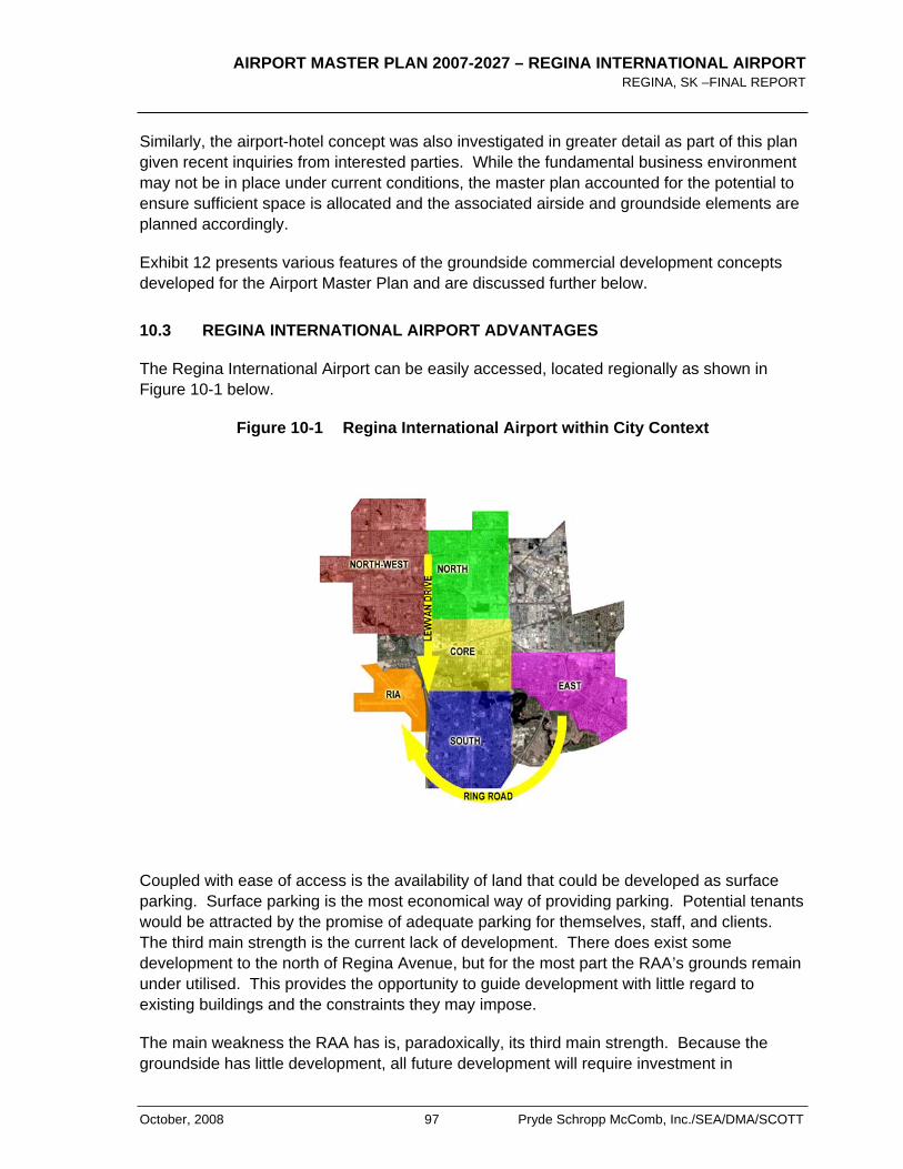
AIRPORT MASTER PLAN 2007-2027 – REGINA INTERNATIONAL AIRPORT REGINA, SK –FINAL REPORT
October, 2008 97 Pryde Schropp McComb, Inc./SEA/DMA/SCOTT
Similarly, the airport-hotel concept was also investigated in greater detail as part of this plan given recent inquiries from interested parties. While the fundamental business environment may not be in place under current conditions, the master plan accounted for the potential to ensure sufficient space is allocated and the associated airside and groundside elements are planned accordingly.
Exhibit 12 presents various features of the groundside commercial development concepts developed for the Airport Master Plan and are discussed further below.
10.3 REGINA INTERNATIONAL AIRPORT ADVANTAGES
The Regina International Airport can be easily accessed, located regionally as shown in Figure 10-1 below.
Figure 10-1 Regina International Airport within City Context
Coupled with ease of access is the availability of land that could be developed as surface parking. Surface parking is the most economical way of providing parking. Potential tenants would be attracted by the promise of adequate parking for themselves, staff, and clients. The third main strength is the current lack of development. There does exist some development to the north of Regina Avenue, but for the most part the RAA’s grounds remain under utilised. This provides the opportunity to guide development with little regard to existing buildings and the constraints they may impose.
The main weakness the RAA has is, paradoxically, its third main strength. Because the groundside has little development, all future development will require investment in
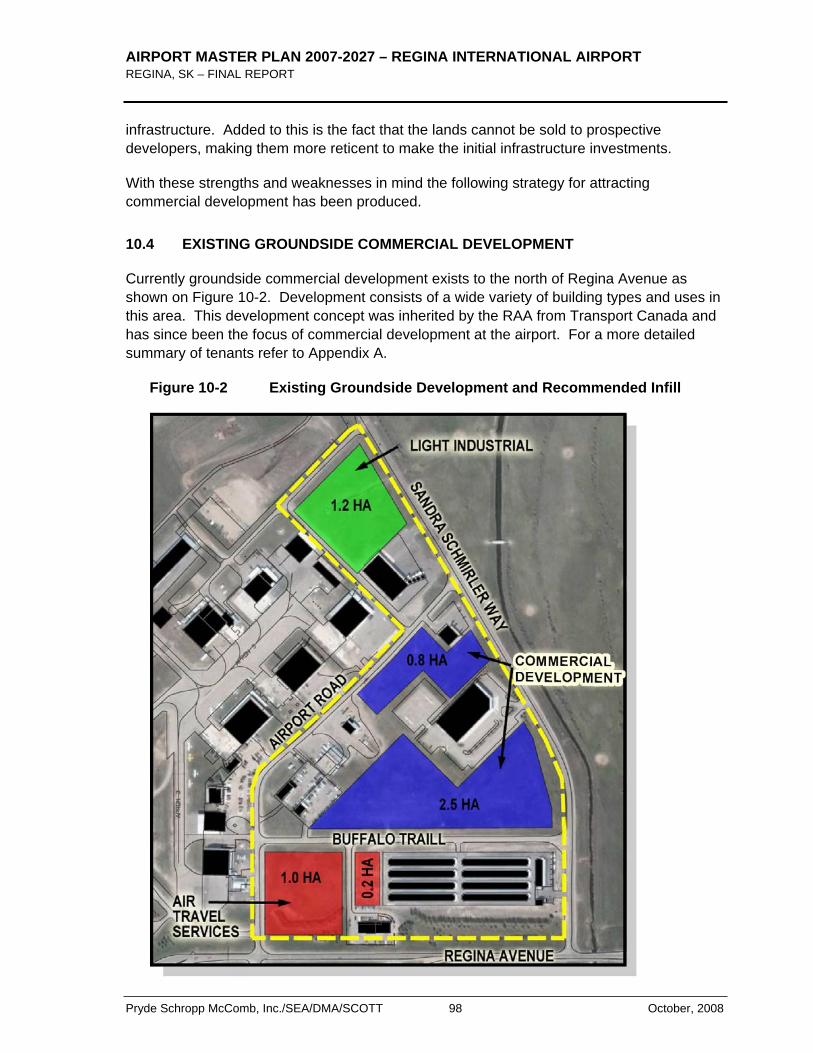
AIRPORT MASTER PLAN 2007-2027 – REGINA INTERNATIONAL AIRPORT REGINA, SK – FINAL REPORT
Pryde Schropp McComb, Inc./SEA/DMA/SCOTT 98 October, 2008
infrastructure. Added to this is the fact that the lands cannot be sold to prospective developers, making them more reticent to make the initial infrastructure investments.
With these strengths and weaknesses in mind the following strategy for attracting commercial development has been produced.
10.4 EXISTING GROUNDSIDE COMMERCIAL DEVELOPMENT
Currently groundside commercial development exists to the north of Regina Avenue as shown on Figure 10-2. Development consists of a wide variety of building types and uses in this area. This development concept was inherited by the RAA from Transport Canada and has since been the focus of commercial development at the airport. For a more detailed summary of tenants refer to Appendix A.
Figure 10-2 Existing Groundside Development and Recommended Infill
AIRPORT MASTER PLAN 2007-2027 – REGINA INTERNATIONAL AIRPORT REGINA, SK –FINAL REPORT
October, 2008 99 Pryde Schropp McComb, Inc./SEA/DMA/SCOTT
There is a loose organizational scheme with businesses that serve air travel (car rentals companies and Cara Flight Kitchen) arrayed along Airport Road, office development along Sandra Schmirler Drive (Sasktel Mobility and Canada Border Services Agency's (CBSA), and light industrial development to the north (Canmar Grains Ltd.). Because of the mix of uses, it would be difficult to impose a general vision or organizational scheme.
The following is a list of current groundside tenants with a short description of their existing facilities:
Canmar Grains Ltd.
Accessed from Sandra Schmirler Way, the Canmar Grains Ltd. building is a large building measuring approximately 55m x 30m. It primary uses are grain storage and some office space. There are a number of large grain bins adjacent to the building. Parking for the building is directly in front of the building with space for approximately 20 cars. There are two loading docks on the east face of the building. The Canmar Grains building was built just recently and is expected to remain well into the long-term range of this document.
Sasktel Mobility
The Sasktel Mobility building is accessed from Sandra Schmirler Way. Measuring almost 40m x 70m it is the largest Groundside commercial Development. There are two floors of office space with a large double-volume entry / vertical circulation space. The primary use for this building is office space. The building is surrounded by a large parking lot with parking for over one hundred cars. This building is expected to remain well into the long term range of this document.
Stor Edge
The Stor Edge Facility is accessed off Sandra Schmirler Way and is directly north of Regina Avenue. There is a small office and nine storage buildings. These storage buildings are divided into secured, storage compartments with overhead doors. Eight of the storage buildings measure in excess of 85m. The remaining storage building measures approximately 35m in length. This facility is relatively new to the Airport grounds and is expected to remain well into the future. It appears that the site’s grade had to be built up prior to construction; this is most likely due to concerns over flooding from the nearby stormwater channel.
Cara Flight Kitchen
The Cara Flight Kitchen facility provides food preparation services to the airlines. It operates out of a relatively small building that is located on Airport Road. It appears that additions have been made to the facility over the years. Due to the necessity of food preparation services to the airlines, Cara Flight Kitchen is likely to remain on the airport grounds for the foreseeable future.
AIRPORT MASTER PLAN 2007-2027 – REGINA INTERNATIONAL AIRPORT REGINA, SK – FINAL REPORT
Pryde Schropp McComb, Inc./SEA/DMA/SCOTT 100 October, 2008
National Car Rental
National Car Rental has a small building and lot accessible from Airport Road. This building serves National’s car rental business.
Avis
Avis has a small building and lot accessible from Buffalo Trail. This building serves Avis’ car rental business.
Budget Car Rental
The Budget Car Rental building is a small structure accessible from Airport Road. It serves Budget in its car rental business.
Service Centre Building for Hertz and Thrifty Car Rentals
This building is approximately 41m long and 15 m wide. It is a one storey building that is used for vehicle servicing.
Canada Border Services Agency (CBSA) Building
Canada Border Services occupy a 17mx22m building, accessed from Airport Road. This building provides office space. The Airport does have international flights and as such Canada Border Services requires a presence on site.
The current development pattern does allow a greater variety of acceptable developments in this area (constraints to development limited only to aeronautical safety, aquifer sensitivity, etc.). The availability of lots and the ease of access and servicing make this area ideal for short-term development. Figure 10-1 also shows a potential infill concept and conceptual land uses.
10.5 NEW GROUNDSIDE DEVELOPMENT RECOMMENDATIONS
New Development Areas
Currently, groundside commercial development exists, almost exclusively, to the north of Regina Avenue between Airport Road and Sandra Schmirler Way. In this area there exist a number of vacant sites that could be developed. It is important to allocate lands so that the available sites remain as contiguous as possible, as development progresses. As such a new development area located immediately south of Regina Ave. shown in Figure 10-3 would serve as a new development area with reasonable connectivity to existing services and the airport road network. This area would also preserve the attractiveness of YQR demonstrating that there is additional commercial groundside land development capacity at the airport. Furthermore, these lands would also permit the RAA to develop a vision and strategy for this area consistent with its strategic objectives rather than trying the “fit” development into the inherited development area north of Regina Ave. Special
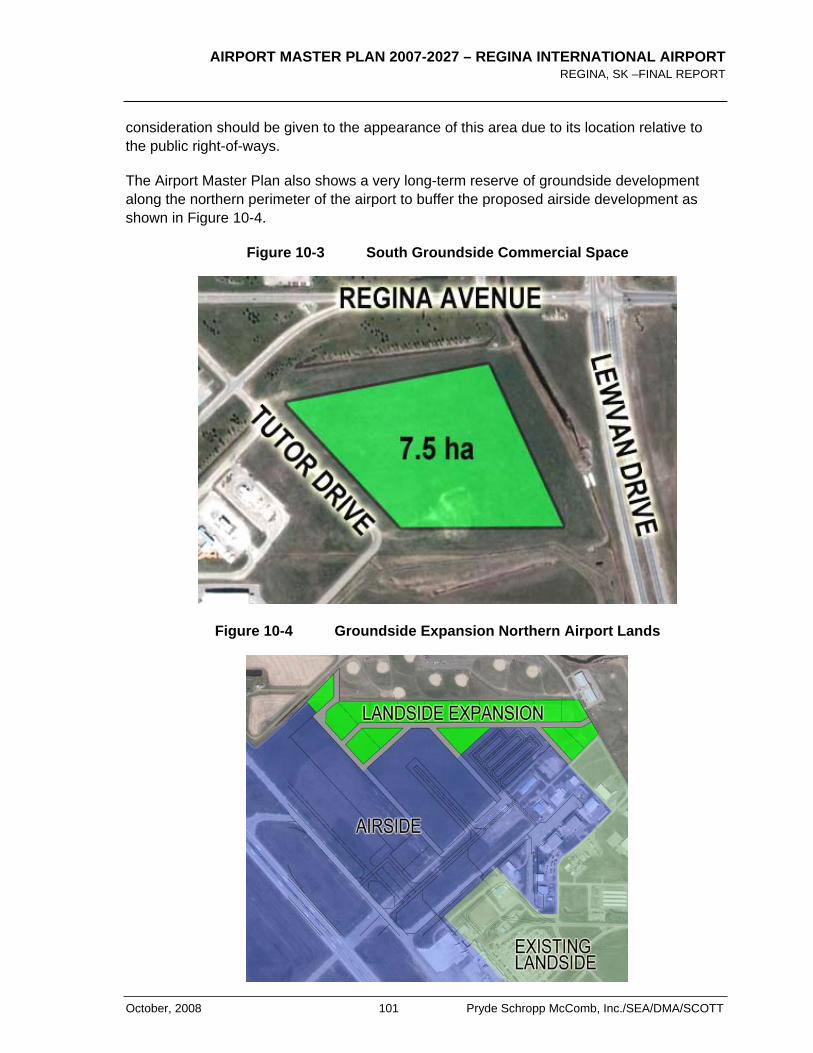
AIRPORT MASTER PLAN 2007-2027 – REGINA INTERNATIONAL AIRPORT REGINA, SK –FINAL REPORT
October, 2008 101 Pryde Schropp McComb, Inc./SEA/DMA/SCOTT
consideration should be given to the appearance of this area due to its location relative to the public right-of-ways.
The Airport Master Plan also shows a very long-term reserve of groundside development along the northern perimeter of the airport to buffer the proposed airside development as shown in Figure 10-4.
Figure 10-3 South Groundside Commercial Space
Figure 10-4 Groundside Expansion Northern Airport Lands
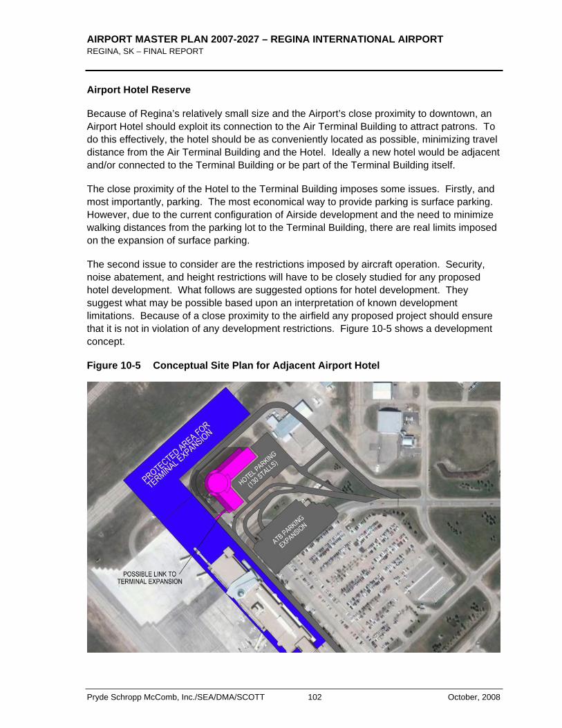
AIRPORT MASTER PLAN 2007-2027 – REGINA INTERNATIONAL AIRPORT REGINA, SK – FINAL REPORT
Pryde Schropp McComb, Inc./SEA/DMA/SCOTT 102 October, 2008
Airport Hotel Reserve
Because of Regina’s relatively small size and the Airport’s close proximity to downtown, an Airport Hotel should exploit its connection to the Air Terminal Building to attract patrons. To do this effectively, the hotel should be as conveniently located as possible, minimizing travel distance from the Air Terminal Building and the Hotel. Ideally a new hotel would be adjacent and/or connected to the Terminal Building or be part of the Terminal Building itself.
The close proximity of the Hotel to the Terminal Building imposes some issues. Firstly, and most importantly, parking. The most economical way to provide parking is surface parking. However, due to the current configuration of Airside development and the need to minimize walking distances from the parking lot to the Terminal Building, there are real limits imposed on the expansion of surface parking.
The second issue to consider are the restrictions imposed by aircraft operation. Security, noise abatement, and height restrictions will have to be closely studied for any proposed hotel development. What follows are suggested options for hotel development. They suggest what may be possible based upon an interpretation of known development limitations. Because of a close proximity to the airfield any proposed project should ensure that it is not in violation of any development restrictions. Figure 10-5 shows a development concept.
Figure 10-5 Conceptual Site Plan for Adjacent Airport Hotel
AIRPORT MASTER PLAN 2007-2027 – REGINA INTERNATIONAL AIRPORT REGINA, SK –FINAL REPORT
October, 2008 103 Pryde Schropp McComb, Inc./SEA/DMA/SCOTT
For a hotel built adjacent to the Air Terminal Building, the area of greatest potential is to the north of the existing Terminal parking lot. Space should be allotted to allow for future Terminal Expansion. In this scheme the hotel has a floor plate large enough to accommodate approximately 44 rooms. Height would be restricted to approximately 35m due to Obstacle Limitation Surfaces. This would allow the construction of a hotel with approximately nine floors, however within the context of the Regina Airport, a hotel of this height is not recommended. Also, a limiting factor for the hotel size would be the room to parking stall ratio. As shown in Figure 10-5 there could be a potential for approximately 178 surface parking stalls. Because of this, it is likely that this hotel development would be around four floors with an approximate 176 rooms. This site plan shows a proposed expansion to the existing Terminal Building Parking Lot. This was done to ensure adequate room for a Terminal Building parking expansion.
Because this type of development could occur completely independently of the day-to-day operations of the Terminal Building, it could occur at any time.
Furthermore, it should be noted that this concept impacted the layout of the future main apron expansion and will ensure flexibility to accommodate the potential hotel concept or not while still preserving the airside apron layouts.
10.6 SITE DEVELOPMENT STRATEGIES (GUIDELINES)
The following site development guidelines were prepared for consideration by the RAA. These guidelines were drafted with particular emphasis on the new development areas. These guidelines could however also be applied for the infill development areas discussed above.
Landscaping
The groundside commercial development should encourage the use of native plant species in its landscape design. When established these species require less irrigation. The plantings should be suitably diverse, providing habitat to insects, small mammals, and small birds. Care should be taken so as not to attract any species to the area that may threaten the safe operation of aircraft. To this end, water features, such as marshes or ponds that could attract waterfowl, should be avoided.
Stormwater Management
The landscaping of the groundside commercial development should be designed as part of an overall stormwater management system. Currently these areas are undeveloped meaning that rainwater can penetrate into the soil. As the groundside commercial development develops, rooftops and parking lots will greatly increase the amount of impervious surfaces, creating much greater stormwater run-off. The groundside commercial development should endeavour to retain/retard this run-off and treat run-off for pollution through the process of bio-remediation. To achieve this, a network of bio-swales is proposed. Bio-swales are broad shallow ditches with a dense ground cover of native plant species. Stormwater run-off from parking lots, roads, and driveways are often polluted with
AIRPORT MASTER PLAN 2007-2027 – REGINA INTERNATIONAL AIRPORT REGINA, SK – FINAL REPORT
Pryde Schropp McComb, Inc./SEA/DMA/SCOTT 104 October, 2008
oils and other chemicals from automobiles. Site grading is done so that water is directed into a bio-swale. The plantings and configuration of the bio-swale slow down the flow rate allowing the water to penetrate into the soil. As the water flows around the plants, impurities and pollutants are removed from the water. The bio-swale network would act in conjunction with the municipal stormwater management system, however by slowing run-off flow and increasing soil infiltration, demand on the municipal system is lessened during times of peak demand; a large rain storm.
Another strategy to employ and encourage is the harvesting of rainwater for the use of site irrigation. Rainwater from rooftops can easily be directed into storage containers. This not only provides site irrigation without the use of potable water, it also minimizes demand on the stormwater management system during peak periods.
Greenways
The network of bio-swales could serve as the basis for a network of greenways throughout the groundside commercial development. Landscape is sculpted to create the bio-swale and plantings are layered to create green corridors throughout the development.
Pedestrian Access / Recreation
Integrated into the network of greenways are pedestrian paths. These paths should be designed in such a way that they could provide access into the site and provide recreation for people on breaks or at lunch. This strategy supports the Groundside commercial development’s environmental sustainability by providing an alternative to the automobile and promotes a healthy lifestyle for people working in the park.
Bicycle Access
To encourage bicycle use in the groundside commercial development a lane for bicycles should be clearly demarcated along the access road.
Parking Configuration
When possible parking lots should be configured in such a fashion so that their depth does not exceed two rows of parking and a driving aisle. Typically, parking stalls are approximately 6m deep and driving aisles are approximately 7.5m. Strips of landscaping should surround parking lots. By controlling parking lot depth the views from inside a building out have at most 19.5m of parking lot before a landscaped strip. Close proximity to greenery creates a more pleasant interior environment inside the office buildings. Also, if the landscaping has sufficiently dense plantings, the buildings are not as exposed to the wind, creating microclimates around the building and decreasing heating costs.
Site Lighting
To decrease the effects of light pollution, site lighting should be strictly controlled. Lighting for exterior spaces should use shielded light fixtures that do not allow light trespass.
AIRPORT MASTER PLAN 2007-2027 – REGINA INTERNATIONAL AIRPORT REGINA, SK –FINAL REPORT
October, 2008 105 Pryde Schropp McComb, Inc./SEA/DMA/SCOTT
Leadership in Energy and Environmental Design (LEED )
The buildings in the Groundside commercial development should follow the principles outlined in the Canada Green Building Council’s Leadership in Energy and Environmental Design (LEED ) program. This standard has been adopted from the United States Green Building Council and represents a North America wide standard of Environmentally Sustainable Design. It is based on a system of points, which provides a way of quantifying the level of environmental sustainability a building has achieved. The principles outlined should be adhered to and certification in the LEED program should be encouraged.
10.7 SUMMARY OF KEY RECOMMENDATIONS
Based on the foregoing, the following recommendations were developed:
1. Currently groundside commercial development exists to the north of Regina Avenue. Development consists of a wide variety of building types and uses in this area. The availability of lots and the ease of access and servicing make this area ideal for short-term development.
2. A vacant parcel of land south of Regina Avenue has a large contiguous area of approximately 7.5 hectares. This area is currently allocated for groundside commercial development. Because there is no existing development in this area there is the opportunity to create a general vision for this location and the RAA is encouraged to further develop a strategic plan for this area as needs arise.
3. Any new commercial development proposals should take into consideration development guidelines as recommended in this Airport Master Plan.

AIRPORT MASTER PLAN 2007-2027 – REGINA INTERNATIONAL AIRPORT REGINA, SK – FINAL REPORT
Pryde Schropp McComb, Inc./SEA/DMA/SCOTT 106 October, 2008
< THIS PAGE LEFT INTENTIONALLY BLANK >
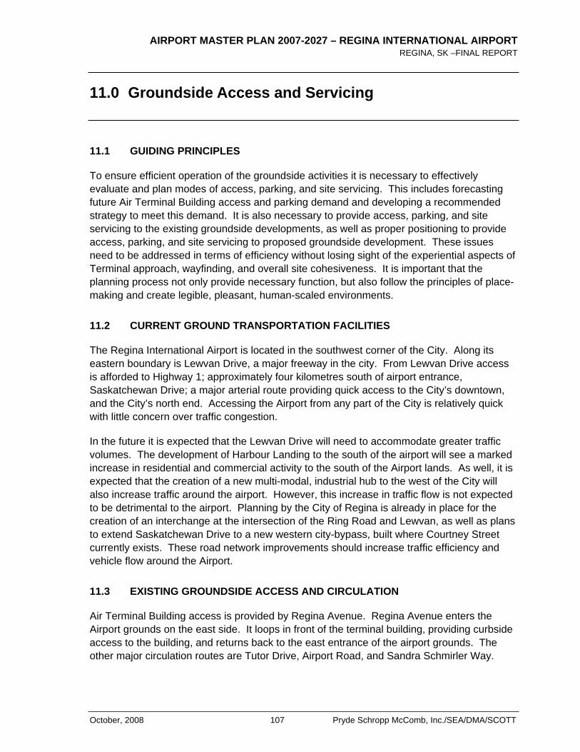
AIRPORT MASTER PLAN 2007-2027 – REGINA INTERNATIONAL AIRPORT REGINA, SK –FINAL REPORT
October, 2008 107 Pryde Schropp McComb, Inc./SEA/DMA/SCOTT
11.0 Groundside Access and Servicing
11.1 GUIDING PRINCIPLES
To ensure efficient operation of the groundside activities it is necessary to effectively evaluate and plan modes of access, parking, and site servicing. This includes forecasting future Air Terminal Building access and parking demand and developing a recommended strategy to meet this demand. It is also necessary to provide access, parking, and site servicing to the existing groundside developments, as well as proper positioning to provide access, parking, and site servicing to proposed groundside development. These issues need to be addressed in terms of efficiency without losing sight of the experiential aspects of Terminal approach, wayfinding, and overall site cohesiveness. It is important that the planning process not only provide necessary function, but also follow the principles of place-making and create legible, pleasant, human-scaled environments.
11.2 CURRENT GROUND TRANSPORTATION FACILITIES
The Regina International Airport is located in the southwest corner of the City. Along its eastern boundary is Lewvan Drive, a major freeway in the city. From Lewvan Drive access is afforded to Highway 1; approximately four kilometres south of airport entrance, Saskatchewan Drive; a major arterial route providing quick access to the City’s downtown, and the City’s north end. Accessing the Airport from any part of the City is relatively quick with little concern over traffic congestion.
In the future it is expected that the Lewvan Drive will need to accommodate greater traffic volumes. The development of Harbour Landing to the south of the airport will see a marked increase in residential and commercial activity to the south of the Airport lands. As well, it is expected that the creation of a new multi-modal, industrial hub to the west of the City will also increase traffic around the airport. However, this increase in traffic flow is not expected to be detrimental to the airport. Planning by the City of Regina is already in place for the creation of an interchange at the intersection of the Ring Road and Lewvan, as well as plans to extend Saskatchewan Drive to a new western city-bypass, built where Courtney Street currently exists. These road network improvements should increase traffic efficiency and vehicle flow around the Airport.
11.3 EXISTING GROUNDSIDE ACCESS AND CIRCULATION
Air Terminal Building access is provided by Regina Avenue. Regina Avenue enters the Airport grounds on the east side. It loops in front of the terminal building, providing curbside access to the building, and returns back to the east entrance of the airport grounds. The other major circulation routes are Tutor Drive, Airport Road, and Sandra Schmirler Way.
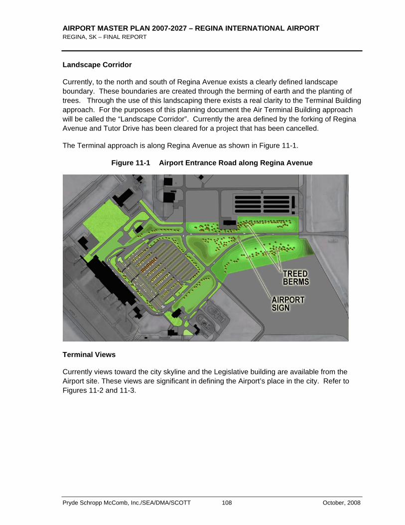
AIRPORT MASTER PLAN 2007-2027 – REGINA INTERNATIONAL AIRPORT REGINA, SK – FINAL REPORT
Pryde Schropp McComb, Inc./SEA/DMA/SCOTT 108 October, 2008
Landscape Corridor
Currently, to the north and south of Regina Avenue exists a clearly defined landscape boundary. These boundaries are created through the berming of earth and the planting of trees. Through the use of this landscaping there exists a real clarity to the Terminal Building approach. For the purposes of this planning document the Air Terminal Building approach will be called the “Landscape Corridor”. Currently the area defined by the forking of Regina Avenue and Tutor Drive has been cleared for a project that has been cancelled.
The Terminal approach is along Regina Avenue as shown in Figure 11-1.
Figure 11-1 Airport Entrance Road along Regina Avenue
Terminal Views
Currently views toward the city skyline and the Legislative building are available from the Airport site. These views are significant in defining the Airport’s place in the city. Refer to Figures 11-2 and 11-3.
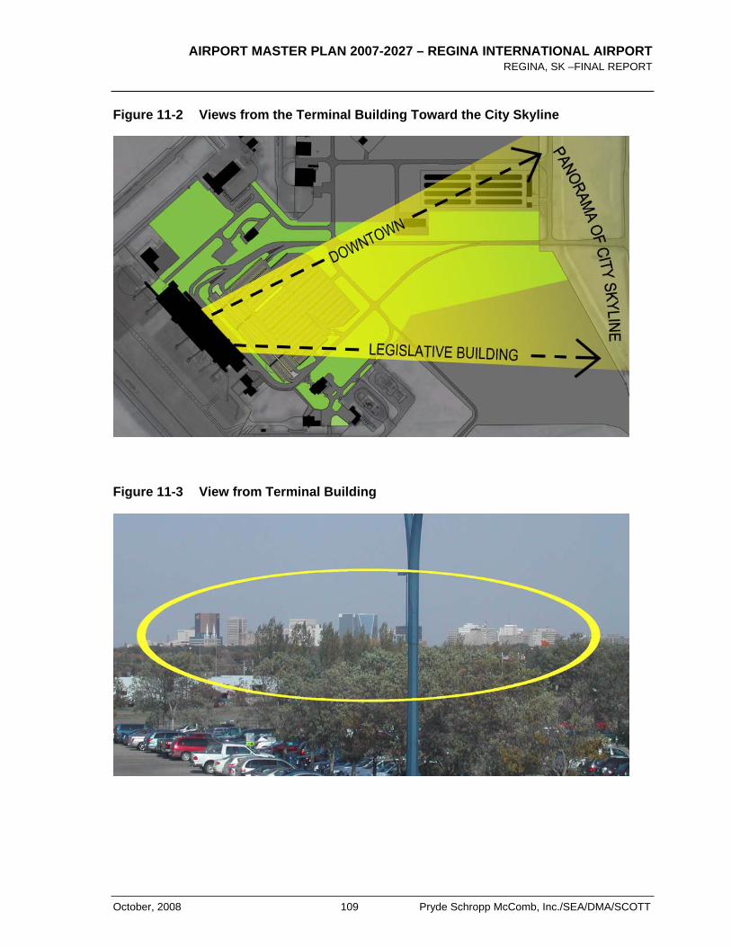
AIRPORT MASTER PLAN 2007-2027 – REGINA INTERNATIONAL AIRPORT REGINA, SK –FINAL REPORT
October, 2008 109 Pryde Schropp McComb, Inc./SEA/DMA/SCOTT
Figure 11-2 Views from the Terminal Building Toward the City Skyline
Figure 11-3 View from Terminal Building
AIRPORT MASTER PLAN 2007-2027 – REGINA INTERNATIONAL AIRPORT REGINA, SK – FINAL REPORT
Pryde Schropp McComb, Inc./SEA/DMA/SCOTT 110 October, 2008
Parking Access
Currently all the Air Terminal Building parking is contained within the loop of Regina Avenue. This makes ingress and egress from the parking lot very straightforward and efficient. This also cuts down on the amount of traffic in front of the terminal building. In the future any expansion of existing parking should be entered on the westbound, northern arm of Regina Avenue. Cars exiting the parking expansion should exit on the eastbound, southern arm of Regina Avenue. This ensures that any cars travelling to or from the parking area do not drive along the Air Terminal Building’s frontage.
Wayfinding and Signage
To ensure ease of access and efficient traffic flow throughout the Airport it is necessary that the site be easy to navigate. The majority of people visiting on site are bound for the Air Terminal Building. Currently accessing the Air Terminal Building is very clear; this should be maintained.
All signage related to wayfinding should be of a similar look and style to add to site legibility and cohesion. Signage should be scaled for its use; signs to alert drivers in cars should be succinct and scaled for easy interpretation at a distance, signage for pedestrians can be more detailed and smaller.
11.4 FUTURE AIRPORT ACCESS AND CIRCULATION REQUIREMENTS
In 2007 the Regina Airport Authority commissioned a study of the current traffic and Groundside infrastructure. This study found that the current circulation routes are adequate for current as well as future demand. If there is significant growth in groundside commercial development , they will require new access roads be built.
11.5 AIRPORT ACCESS RECOMMENDATIONS
Terminal Approach
It is the recommendation of this Airport Master Plan that the Air Terminal Approach be maintained and/or enhanced. The Air Terminal Approach functions as a landscape corridor, providing access simply and efficiently, while also being quite pleasant.
To maintain the clarity of the landscape corridor, it is recommended that the triangular site defined by the forking of Regina Avenue and Tutor Drive be landscaped. This landscaping should be similar in plantings, scale, and density to the rest of the Landscape Corridor. Development should not be allowed on this site. Any development would obscure the Terminal Building approach.
Figure 11-4 illustrates the detrimental effect of development on this site. A building on this site becomes the most visually dominant structure.
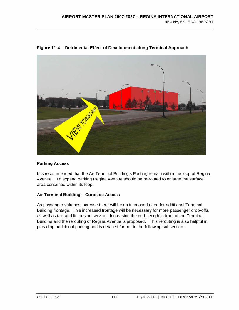
AIRPORT MASTER PLAN 2007-2027 – REGINA INTERNATIONAL AIRPORT REGINA, SK –FINAL REPORT
October, 2008 111 Pryde Schropp McComb, Inc./SEA/DMA/SCOTT
Figure 11-4 Detrimental Effect of Development along Terminal Approach
Parking Access
It is recommended that the Air Terminal Building’s Parking remain within the loop of Regina Avenue. To expand parking Regina Avenue should be re-routed to enlarge the surface area contained within its loop.
Air Terminal Building – Curbside Access
As passenger volumes increase there will be an increased need for additional Terminal Building frontage. This increased frontage will be necessary for more passenger drop-offs, as well as taxi and limousine service. Increasing the curb length in front of the Terminal Building and the rerouting of Regina Avenue is proposed. This rerouting is also helpful in providing additional parking and is detailed further in the following subsection.
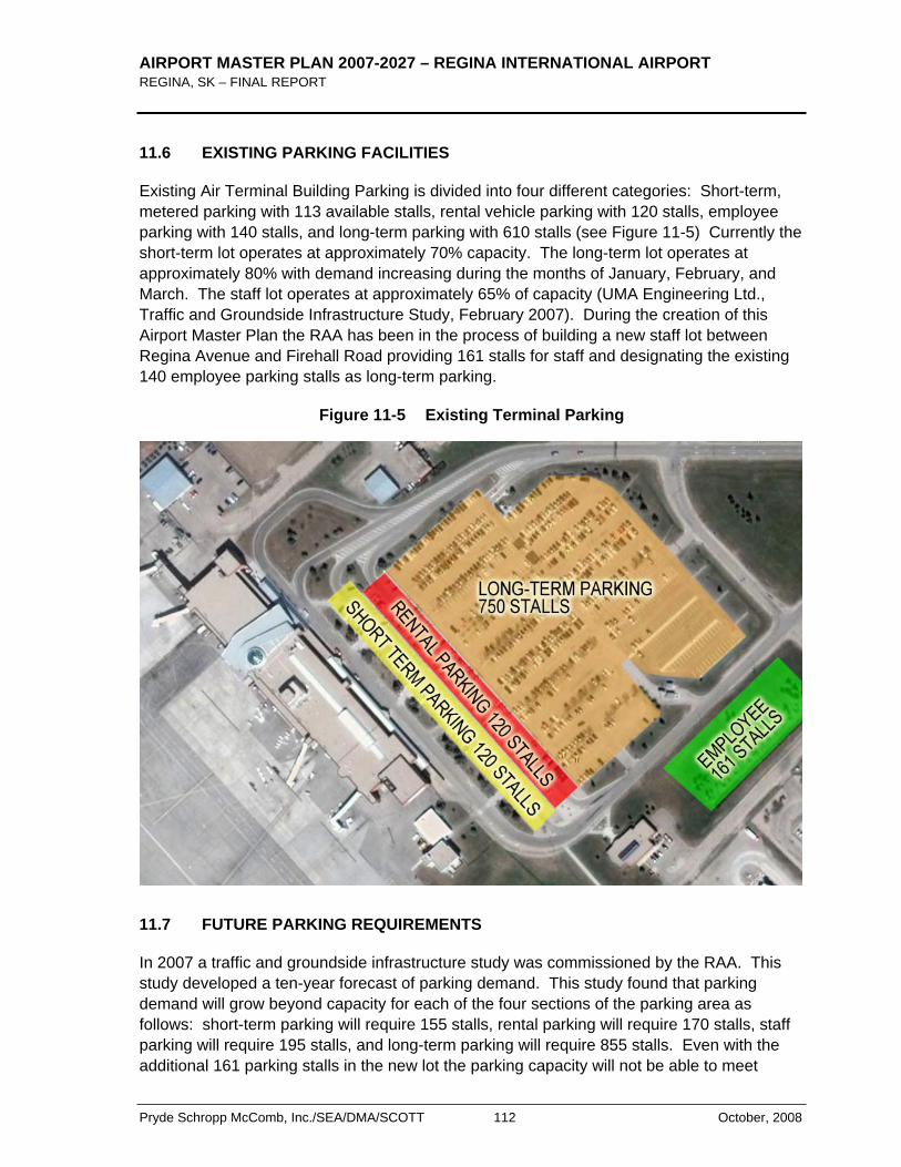
AIRPORT MASTER PLAN 2007-2027 – REGINA INTERNATIONAL AIRPORT REGINA, SK – FINAL REPORT
Pryde Schropp McComb, Inc./SEA/DMA/SCOTT 112 October, 2008
11.6 EXISTING PARKING FACILITIES
Existing Air Terminal Building Parking is divided into four different categories: Short-term, metered parking with 113 available stalls, rental vehicle parking with 120 stalls, employee parking with 140 stalls, and long-term parking with 610 stalls (see Figure 11-5) Currently the short-term lot operates at approximately 70% capacity. The long-term lot operates at approximately 80% with demand increasing during the months of January, February, and March. The staff lot operates at approximately 65% of capacity (UMA Engineering Ltd., Traffic and Groundside Infrastructure Study, February 2007). During the creation of this Airport Master Plan the RAA has been in the process of building a new staff lot between Regina Avenue and Firehall Road providing 161 stalls for staff and designating the existing 140 employee parking stalls as long-term parking.
Figure 11-5 Existing Terminal Parking
11.7 FUTURE PARKING REQUIREMENTS
In 2007 a traffic and groundside infrastructure study was commissioned by the RAA. This study developed a ten-year forecast of parking demand. This study found that parking demand will grow beyond capacity for each of the four sections of the parking area as follows: short-term parking will require 155 stalls, rental parking will require 170 stalls, staff parking will require 195 stalls, and long-term parking will require 855 stalls. Even with the additional 161 parking stalls in the new lot the parking capacity will not be able to meet
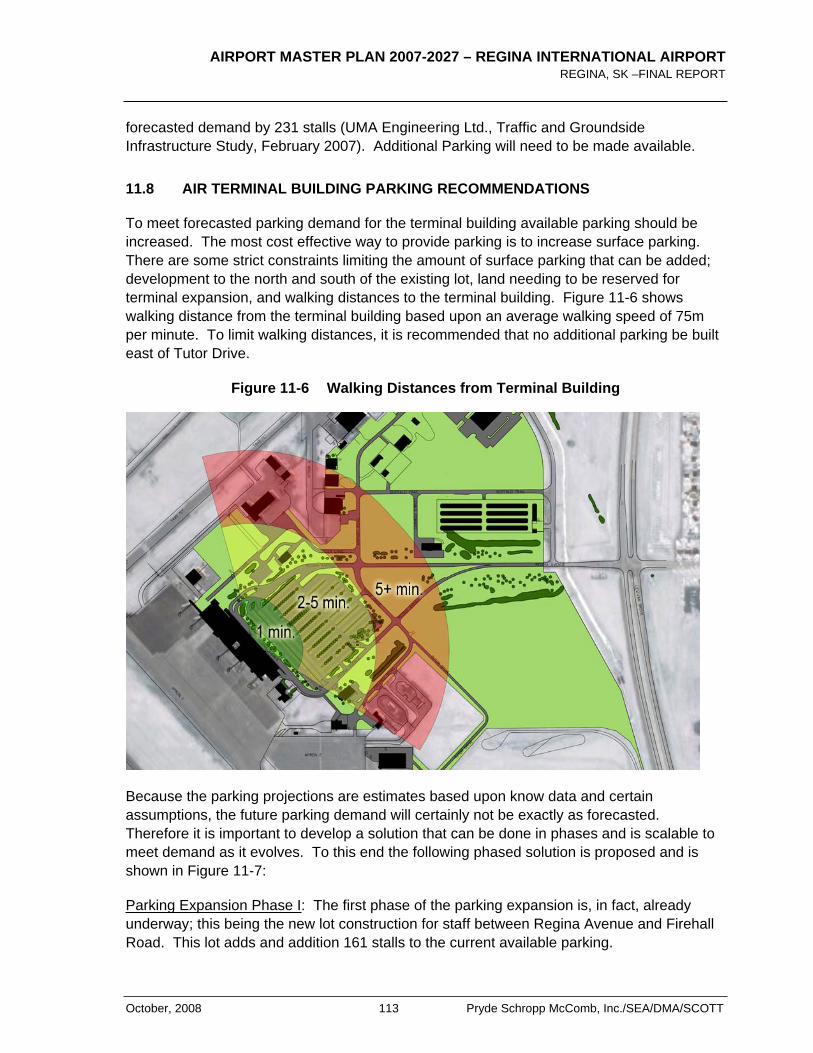
AIRPORT MASTER PLAN 2007-2027 – REGINA INTERNATIONAL AIRPORT REGINA, SK –FINAL REPORT
October, 2008 113 Pryde Schropp McComb, Inc./SEA/DMA/SCOTT
forecasted demand by 231 stalls (UMA Engineering Ltd., Traffic and Groundside Infrastructure Study, February 2007). Additional Parking will need to be made available.
11.8 AIR TERMINAL BUILDING PARKING RECOMMENDATIONS
To meet forecasted parking demand for the terminal building available parking should be increased. The most cost effective way to provide parking is to increase surface parking. There are some strict constraints limiting the amount of surface parking that can be added; development to the north and south of the existing lot, land needing to be reserved for terminal expansion, and walking distances to the terminal building. Figure 11-6 shows walking distance from the terminal building based upon an average walking speed of 75m per minute. To limit walking distances, it is recommended that no additional parking be built east of Tutor Drive.
Figure 11-6 Walking Distances from Terminal Building
Because the parking projections are estimates based upon know data and certain assumptions, the future parking demand will certainly not be exactly as forecasted. Therefore it is important to develop a solution that can be done in phases and is scalable to meet demand as it evolves. To this end the following phased solution is proposed and is shown in Figure 11-7:
Parking Expansion Phase I: The first phase of the parking expansion is, in fact, already underway; this being the new lot construction for staff between Regina Avenue and Firehall Road. This lot adds and addition 161 stalls to the current available parking.
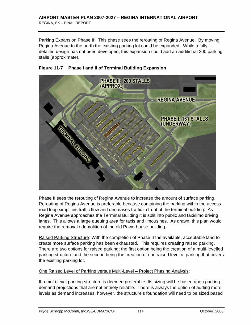
AIRPORT MASTER PLAN 2007-2027 – REGINA INTERNATIONAL AIRPORT REGINA, SK – FINAL REPORT
Pryde Schropp McComb, Inc./SEA/DMA/SCOTT 114 October, 2008
Parking Expansion Phase II: This phase sees the rerouting of Regina Avenue. By moving Regina Avenue to the north the existing parking lot could be expanded. While a fully detailed design has not been developed, this expansion could add an additional 200 parking stalls (approximate).
Figure 11-7 Phase I and II of Terminal Building Expansion
Phase II sees the rerouting of Regina Avenue to increase the amount of surface parking. Rerouting of Regina Avenue is preferable because containing the parking within the access road loop simplifies traffic flow and decreases traffic in front of the terminal building. As Regina Avenue approaches the Terminal Building it is split into public and taxi/limo driving lanes. This allows a large queuing area for taxis and limousines. As drawn, this plan would require the removal / demolition of the old Powerhouse building.
Raised Parking Structure: With the completion of Phase II the available, acceptable land to create more surface parking has been exhausted. This requires creating raised parking. There are two options for raised parking; the first option being the creation of a multi-levelled parking structure and the second being the creation of one raised level of parking that covers the existing parking lot.
One Raised Level of Parking versus Multi-Level – Project Phasing Analysis:
If a multi-level parking structure is deemed preferable. Its sizing will be based upon parking demand projections that are not entirely reliable. There is always the option of adding more levels as demand increases, however, the structure’s foundation will need to be sized based
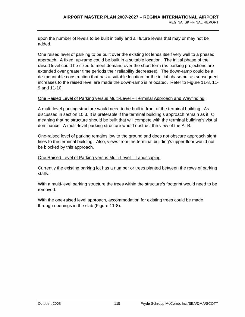
AIRPORT MASTER PLAN 2007-2027 – REGINA INTERNATIONAL AIRPORT REGINA, SK –FINAL REPORT
October, 2008 115 Pryde Schropp McComb, Inc./SEA/DMA/SCOTT
upon the number of levels to be built initially and all future levels that may or may not be added.
One raised level of parking to be built over the existing lot lends itself very well to a phased approach. A fixed, up-ramp could be built in a suitable location. The initial phase of the raised level could be sized to meet demand over the short term (as parking projections are extended over greater time periods their reliability decreases). The down-ramp could be a de-mountable construction that has a suitable location for the initial phase but as subsequent increases to the raised level are made the down-ramp is relocated. Refer to Figure 11-8, 11-9 and 11-10.
One Raised Level of Parking versus Multi-Level – Terminal Approach and Wayfinding:
A multi-level parking structure would need to be built in front of the terminal building. As discussed in section 10.3. It is preferable if the terminal building’s approach remain as it is; meaning that no structure should be built that will compete with the terminal building’s visual dominance. A multi-level parking structure would obstruct the view of the ATB.
One-raised level of parking remains low to the ground and does not obscure approach sight lines to the terminal building. Also, views from the terminal building’s upper floor would not be blocked by this approach.
One Raised Level of Parking versus Multi-Level – Landscaping:
Currently the existing parking lot has a number or trees planted between the rows of parking stalls.
With a multi-level parking structure the trees within the structure’s footprint would need to be removed.
With the one-raised level approach, accommodation for existing trees could be made through openings in the slab (Figure 11-8).
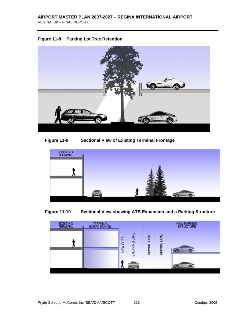
AIRPORT MASTER PLAN 2007-2027 – REGINA INTERNATIONAL AIRPORT REGINA, SK – FINAL REPORT
Pryde Schropp McComb, Inc./SEA/DMA/SCOTT 116 October, 2008
Figure 11-8 Parking Lot Tree Retention
Figure 11-9 Sectional View of Existing Terminal Frontage
Figure 11-10 Sectional View showing ATB Expansion and a Parking Structure
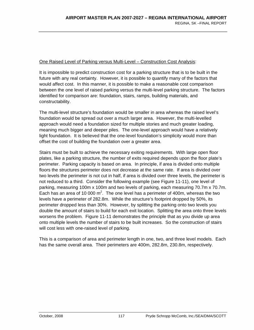
AIRPORT MASTER PLAN 2007-2027 – REGINA INTERNATIONAL AIRPORT REGINA, SK –FINAL REPORT
October, 2008 117 Pryde Schropp McComb, Inc./SEA/DMA/SCOTT
One Raised Level of Parking versus Multi-Level – Construction Cost Analysis:
It is impossible to predict construction cost for a parking structure that is to be built in the future with any real certainty. However, it is possible to quantify many of the factors that would affect cost. In this manner, it is possible to make a reasonable cost comparison between the one level of raised parking versus the multi-level parking structure. The factors identified for comparison are: foundation, stairs, ramps, building materials, and constructability.
The multi-level structure’s foundation would be smaller in area whereas the raised level’s foundation would be spread out over a much larger area. However, the multi-levelled approach would need a foundation sized for multiple stories and much greater loading, meaning much bigger and deeper piles. The one-level approach would have a relatively light foundation. It is believed that the one-level foundation’s simplicity would more than offset the cost of building the foundation over a greater area.
Stairs must be built to achieve the necessary exiting requirements. With large open floor plates, like a parking structure, the number of exits required depends upon the floor plate’s perimeter. Parking capacity is based on area. In principle, if area is divided onto multiple floors the structures perimeter does not decrease at the same rate. If area is divided over two levels the perimeter is not cut in half, if area is divided over three levels, the perimeter is not reduced to a third. Consider the following example (see Figure 11-11), one level of parking, measuring 100m x 100m and two levels of parking, each measuring 70.7m x 70.7m. Each has an area of 10 000 m2. The one level has a perimeter of 400m, whereas the two levels have a perimeter of 282.8m. While the structure’s footprint dropped by 50%, its perimeter dropped less than 30%. However, by splitting the parking onto two levels you double the amount of stairs to build for each exit location. Splitting the area onto three levels worsens the problem. Figure 11-11 demonstrates the principle that as you divide up area onto multiple levels the number of stairs to be built increases. So the construction of stairs will cost less with one-raised level of parking.
This is a comparison of area and perimeter length in one, two, and three level models. Each has the same overall area. Their perimeters are 400m, 282.8m, 230.8m, respectively.
AIRPORT MASTER PLAN 2007-2027 – REGINA INTERNATIONAL AIRPORT REGINA, SK – FINAL REPORT
Pryde Schropp McComb, Inc./SEA/DMA/SCOTT 118 October, 2008
Figure 11-11 Area/Perimeter Comparison
One raised level of parking requires only two ramps be built, one up the other down. A multi-level structure requires two ramps for every level. Again, the one level structure costs less.
The one level structure would use less material per unit of area built. The structures would both made of concrete. The necessary spans would be the same between the two structures so floor assembly would be essentially the same amount of material. However, because the columns would be supporting a greater load, in the multi-level structure, they would be thicker.
Finally, creating one raised level would be a much simpler structure to build and more easily phased. There is no need to raise concrete a great distance off the ground. The work is not being done high off the ground so it is much safer.
Because of the above analysis comparing the options of a one-raised level of parking and a multi-level parking structure, it is recommended that the one-raised level of parking be pursued.
Parking Expansion Phase III: At this stage parking capacity has been out-stripped by demand or will be in the very near future (Based upon the short-term forecasted demand the first phase of the raised level is sized). For the sake of the Airport Master Plan, this phase is sized to add an additional 146 stalls. It should be clear that this number is somewhat arbitrary and was chosen for illustrative purposes. Supporting columns will most likely be spaced every two to three stalls along the existing parking stalls and on either side of the driving aisle and at the ends of the parking stalls on the ground floor and the columns will not be substantially wide (see Figure 11-12). Ground level parking will be reconfigured to suit the column grid. The new up-ramp is built adjacent to the long term parking entrance. The down-ramp is designed and constructed in such a fashion so that it could be de-mounted, moved and re-mounted for future expansion.
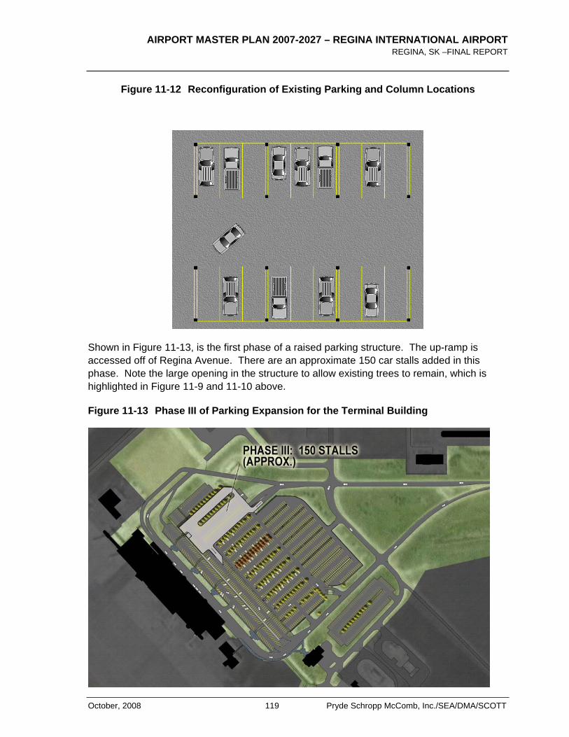
AIRPORT MASTER PLAN 2007-2027 – REGINA INTERNATIONAL AIRPORT REGINA, SK –FINAL REPORT
October, 2008 119 Pryde Schropp McComb, Inc./SEA/DMA/SCOTT
Figure 11-12 Reconfiguration of Existing Parking and Column Locations
Shown in Figure 11-13, is the first phase of a raised parking structure. The up-ramp is accessed off of Regina Avenue. There are an approximate 150 car stalls added in this phase. Note the large opening in the structure to allow existing trees to remain, which is highlighted in Figure 11-9 and 11-10 above.
Figure 11-13 Phase III of Parking Expansion for the Terminal Building
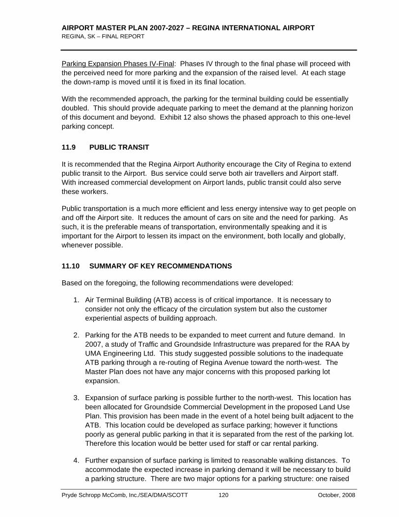
AIRPORT MASTER PLAN 2007-2027 – REGINA INTERNATIONAL AIRPORT REGINA, SK – FINAL REPORT
Pryde Schropp McComb, Inc./SEA/DMA/SCOTT 120 October, 2008
Parking Expansion Phases IV-Final: Phases IV through to the final phase will proceed with the perceived need for more parking and the expansion of the raised level. At each stage the down-ramp is moved until it is fixed in its final location.
With the recommended approach, the parking for the terminal building could be essentially doubled. This should provide adequate parking to meet the demand at the planning horizon of this document and beyond. Exhibit 12 also shows the phased approach to this one-level parking concept.
11.9 PUBLIC TRANSIT
It is recommended that the Regina Airport Authority encourage the City of Regina to extend public transit to the Airport. Bus service could serve both air travellers and Airport staff. With increased commercial development on Airport lands, public transit could also serve these workers.
Public transportation is a much more efficient and less energy intensive way to get people on and off the Airport site. It reduces the amount of cars on site and the need for parking. As such, it is the preferable means of transportation, environmentally speaking and it is important for the Airport to lessen its impact on the environment, both locally and globally, whenever possible.
11.10 SUMMARY OF KEY RECOMMENDATIONS
Based on the foregoing, the following recommendations were developed:
1. Air Terminal Building (ATB) access is of critical importance. It is necessary to consider not only the efficacy of the circulation system but also the customer experiential aspects of building approach.
2. Parking for the ATB needs to be expanded to meet current and future demand. In 2007, a study of Traffic and Groundside Infrastructure was prepared for the RAA by UMA Engineering Ltd. This study suggested possible solutions to the inadequate ATB parking through a re-routing of Regina Avenue toward the north-west. The Master Plan does not have any major concerns with this proposed parking lot expansion.
3. Expansion of surface parking is possible further to the north-west. This location has been allocated for Groundside Commercial Development in the proposed Land Use Plan. This provision has been made in the event of a hotel being built adjacent to the ATB. This location could be developed as surface parking; however it functions poorly as general public parking in that it is separated from the rest of the parking lot. Therefore this location would be better used for staff or car rental parking.
4. Further expansion of surface parking is limited to reasonable walking distances. To accommodate the expected increase in parking demand it will be necessary to build a parking structure. There are two major options for a parking structure: one raised
AIRPORT MASTER PLAN 2007-2027 – REGINA INTERNATIONAL AIRPORT REGINA, SK –FINAL REPORT
October, 2008 121 Pryde Schropp McComb, Inc./SEA/DMA/SCOTT
level of parking built over the existing parking lot or a multi-level parking structure. The one raised level option is recommended in that it should be less expensive to build, easily phased, and has the ability to be expanded, as required, rather than relying on parking demand forecasts. Any parking structure will need to respect the possibility of ATB expansion, in particular the proposed 9m Terminal widening.

AIRPORT MASTER PLAN 2007-2027 – REGINA INTERNATIONAL AIRPORT REGINA, SK – FINAL REPORT
Pryde Schropp McComb, Inc./SEA/DMA/SCOTT 122 October, 2008
< THIS PAGE LEFT INTENTIONALLY BLANK >
AIRPORT MASTER PLAN 2007-2027 – REGINA INTERNATIONAL AIRPORT REGINA, SK –FINAL REPORT
October, 2008 123 Pryde Schropp McComb, Inc./SEA/DMA/SCOTT
12.0 Environment
12.1 GENERAL
The RAA has been very proactive in managing and executing its environmental management system. Prior to transfer of the airport from Transport Canada to the RAA in 1999, an environmental baseline study was conducted by Transport Canada. The findings and recommendations of this study are continuously reviewed, monitored and implemented by the RAA.
As part of their efforts, the RAA continuously updates and implements its Environmental Management Program (EMP) including the monitoring the water quality, aircraft de-icing procedures, and glycol runoff at the Airport. The development of a comprehensive Environmental Management System is currently in progress.
12.2 RAA ENVIRONMENTAL POLICY
The Regina Airport Authority is committed to operating the Regina International Airport in an environmentally responsible manner. The RAA developed an Environmental Policy which forms the basis of their Environmental Management Programs. The following summarizes the RAA’s Environmental Policy:
“…..The Regina Airport Authority is committed to operating the Regina International Airport in an environmentally responsible manner.
The Regina Airport Authority will:
Commit to comply with, or exceed, all applicable environmental legislation and regulations, and other environmental commitments.
Commit to reduce or prevent pollution resulting from airport operations wherever possible and practical.
Identify and manage the Airport’s significant environmental aspects through implementation of a formal environmental management system compliant with the ISO 14001 Standard
Ensure that employees, tenants, contractors, suppliers and users each understand their individual environmental roles and responsibilities
Measure the Airport’s environmental performance and continuously improve the environmental management system
Integrate environmental considerations into all airport planning, operations and development
AIRPORT MASTER PLAN 2007-2027 – REGINA INTERNATIONAL AIRPORT REGINA, SK – FINAL REPORT
Pryde Schropp McComb, Inc./SEA/DMA/SCOTT 124 October, 2008
Consider public needs and opinions in the environmental management of the airport
Report to the local community on the Airport’s environmental performance….”
12.3 ENVIRONMENTAL PRACTICES
Responsible environmental practice employs planning tools and operational procedures to minimize potential negative environmental impacts that might otherwise arise from aircraft operations, land use activities or the development process. The following summarises key environmental practices that have been or will be put in place as a result of the future adoption of the EMS. These practices have not changed significantly since the adoption of the 2001-2021 Airport Master Plan however they have been re-iterated below:
Environmental Assessments
The RAA reviews all airport projects to ascertain their potential environmental impacts. The Environmental Review Process considers the biological, physical, and social impacts of all projects, and involves the preparation of an Environmental Review Report by airport personnel before a project is authorized to proceed. The Canadian Environmental Assessment Act (CEAA) is used as a guide for all environmental assessments
Environmental Audits
These are objective evaluations of the environmental state of the facility. RAA personnel will conduct annual tenant audits to determine the effectiveness of tenant environmental systems and to ensure compliance with environmental legislation. An external firm will perform audits of the entire airport site and RAA facilities to evaluate the environmental management system, the environmental quality of the site, and the fulfilment of legal requirements.
Environmental Emergency Response
The RAA has Environmental Emergency Response Plan (EERP) that specifies procedures and measures to follow in case of accidental release of hazardous substances on the site. It outlines the responsibilities of RAA staff and the various organizations that may be involved in emergency response and documents response procedures and guidelines for different spillage events.

AIRPORT MASTER PLAN 2007-2027 – REGINA INTERNATIONAL AIRPORT REGINA, SK –FINAL REPORT
October, 2008 125 Pryde Schropp McComb, Inc./SEA/DMA/SCOTT
Environmental Quality Monitoring
Water
The RAA developed a water sampling program in 2001 with locations for additional sampling stations identified in and around the airport. As part of the Airport Authority’s environmental due diligence undertakings, water sampling activities will take place, when required, through the utilization of the airport’s water sampling station(s).
Air
Given the relatively low number of aircraft movements at the Regina Airport and minimal amount of ground vehicle traffic on the site, airport operations probably have no significant impact upon local air quality. It is therefore unnecessary to implement an air quality monitoring program. As air traffic increases over the longer-term, however, the RAA may initiate air quality studies to determine the effect airport operations have on the local atmosphere. Refer to Section 12.4 below for additional information on airport air quality.
Materials Management
The RAA follows the most stringent guidelines regarding the handling of all hazardous and regulated materials, whether the guidelines are municipal, provincial, or federal. The Airport Authority has taken care to remove all hazardous materials, such as asbestos, known to be present in RAA owned buildings. To properly manage remaining materials on the site (located in tenant facilities or previously undetected) the Airport Authority will be initiating a Hazardous Materials Inventory. The products to be inventoried include various hazardous materials, ozone-depleting substances, green house gases, PCBs and asbestos. Where appropriate, the inventory will ensure that these substances are removed or their presence phased out from the airport property.
Management of Flora and Fauna
Incidents between wildlife and aircraft, including strikes and near misses, can be a serious safety concern. Although there are relatively few wildlife incidences at the airport, the RAA is determined to remain vigilant and minimize aircraft/wildlife conflicts in the most environmentally sensitive manner possible. The Airport Authority operates a flora and fauna management program31 that integrates habitat modification, land use planning, dispersal methods, exclusion methods, and removal methods. Identified problem species are targeted and dealt with using the most effective techniques for the species in question. The RAA also takes care to warn flight crews about potential wildlife hazards; record and report all wildlife incidents; and ensure that wildlife control personnel are available 24 hours a day, seven days a week.
AIRPORT MASTER PLAN 2007-2027 – REGINA INTERNATIONAL AIRPORT REGINA, SK – FINAL REPORT
Pryde Schropp McComb, Inc./SEA/DMA/SCOTT 126 October, 2008
Contaminated Sites
Prior to the transfer of airport operations to the Regina Airport Authority, the site was subjected to a full environmental audit to identify prevailing environmental conditions at the airport. The 1998 Regina Airport Environmental Baseline Study found that the site possessed few areas of environmental concern.
Of the few areas identified, environmental risks were considered to be limited and remedial measures were not recommended or undertaken. The RAA is aware of the condition of these areas and continues to monitor the entire airport site to avoid future contamination.
The RAA continues to use the results of this study, along with historical data, as a record of past soil contamination. This information is considered during the planning of all airport projects and operations.
12.4 AIR QUALITY
During the preparation of this Airport Master Plan, concerns were expressed about the potential impacts on air quality associated with the growth in aircraft and the changes in the mix of aircraft at the Airport over the next 20 years. While a full air quality analysis was not part of the scope of this Airport Master Plan, research into current literature on this topic was completed. Below is an extract from an article summarizing current research into air quality and Airports:
“….An Airport is a transport and economic hub where air activity and surface activities are concentrated and, as a consequence of fuel combustion in these activities, emissions of air pollutants occur. The emissions mix with existing concentrations of pollutants which result from emissions occurring over a much wider geographical area. An empirical approach can be taken to quantify the relative importance of various sources affecting air quality at an Airport. One of the Airport emission sources is, of course, air operations and this source needs to be quantified and assessed as to its relative importance. An Airport is, however, located in a community and that community has perceptions of air pollution. The community does not necessarily discriminate between sources of pollution and pollutant species; there are likely to be concerns regarding odour, fuel spotting and health which relate directly to the perception of the problem. Invariably aircraft emissions are identified as the main culprit. Hence, there is a perception issue intertwined with an empirical assessment of the relative importance of Airports and other sources as degraders of air quality (Longhurst, 1991). An empirical assessment of the relative importance of aviation activity as a source of emissions in the UK is shown in Table 1. From these data it can be seen that, at best, aviation emissions contribute less than 1% of the total emission strength for any species.
Tropospheric air quality impacts
The troposphere is the bottom 10 km or so of the earth's atmosphere in which almost all weather phenomena develop. It is an unstable region of the atmosphere
AIRPORT MASTER PLAN 2007-2027 – REGINA INTERNATIONAL AIRPORT REGINA, SK –FINAL REPORT
October, 2008 127 Pryde Schropp McComb, Inc./SEA/DMA/SCOTT
characterized by convective air mixing and declining temperature with altitude. The bottom 1 km of the troposphere (and the atmosphere) is conventionally referred to as the boundary layer. This area is a highly turbulent mixing zone where the atmosphere interacts with the earth's surface and it is also where the landing and take off operations of an Airport are con-ducted. All earth surface emissions are released into the boundary layer including those from air-port sources.
Pollutants of concern
Numerous pollutants are emitted from fuel combustion and other Airport activities. The most important of these are oxides of nitrogen, hydrocarbons (also referred to by the broader term volatile organic compounds (VOCs) which include carbon in combination with elements other than hydrogen) and carbon monoxide. Oxides of nitrogen There are many nitrogen species, the most important in air quality terms being NO and NO2. These two nitrogen compounds are known collectively as oxides of nitrogen or NOx. They are emitted from aircraft and surface fuel combustion
Air quality at Airports in the future
Emissions from groundside vehicle movements can significantly degrade the air quality in the vicinity of an Airport. It is generally agreed that the largest single contributor to concentrations of pollutants in the vicinity of an Airport is the car. Catalysts on motor vehicles will continue to reduce emissions of NOR, hydrocarbons and CO from the car fleet over the next 10-15 years. Over this timescale however aircraft emissions of NOR may increase due to both changes in technology and the in-crease in air traffic movements. For example, aviation traffic forecasts estimate a 6% growth rate per year of passengers and a 3% growth rate for aircraft numbers. The calculation of future emissions from the ICAO's `average Airport' illustrates how both hydrocarbon and NOR emissions will change as technology and other factors change over the next 10-12 years (Nitsche and Walker, 1990). Taking into account traffic forecasts and changes in the air-craft fleet mix, the ICAO have compared the 1987 and 2005 aircraft engine emissions from an `average Airport'. The reference Airport handles 21 million passengers in 1987 with 140 000 air movements each with a seat load factor of 70%. Calculations for 2005 replace Chapter 2 aircraft with Chapter 3 aircraft equipped with the present engine technology and a doubling of passengers throughput is assumed. By 2005 the total mass of hydrocarbon emissions will have fallen by 71%, CO emissions will have fallen by 18% but NOR emissions will rise by 110%, as shown in Table 9. The forecast serves to illustrate the scale of changes in aircraft emissions and highlights the increasing role of NOR emissions. Such future changes need to be evaluated in the context of downward pressure on other emission sources and the legitimate expectations of the general public for a cleaner environment. Such expectations allied to the activities of pressure groups can give rise to pressure for change, in particular where the public perceive an Airport to be a major pollution source. Local residents tend to view Airports as noisy, dirty, smelly and generally unpleasant. Many of their concerns relate to the smell of an Airport and the noise. The perception of the above can be altered by addressing the nuisance value of these two issues.
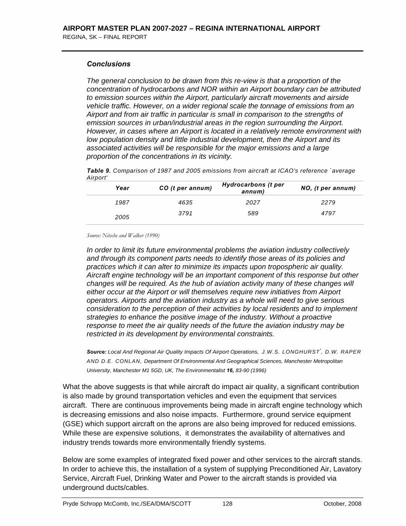
AIRPORT MASTER PLAN 2007-2027 – REGINA INTERNATIONAL AIRPORT REGINA, SK – FINAL REPORT
Pryde Schropp McComb, Inc./SEA/DMA/SCOTT 128 October, 2008
Conclusions
The general conclusion to be drawn from this re-view is that a proportion of the concentration of hydrocarbons and NOR within an Airport boundary can be attributed to emission sources within the Airport, particularly aircraft movements and airside vehicle traffic. However, on a wider regional scale the tonnage of emissions from an Airport and from air traffic in particular is small in comparison to the strengths of emission sources in urban/industrial areas in the region surrounding the Airport. However, in cases where an Airport is located in a relatively remote environment with low population density and little industrial development, then the Airport and its associated activities will be responsible for the major emissions and a large proportion of the concentrations in its vicinity.
Table 9. Comparison of 1987 and 2005 emissions from aircraft at ICAO's reference `average Airport'
Year CO (t per annum) Hydrocarbons (t per annum) NO, (t per annum)
1987 4635 2027 2279
2005 3791 589 4797
Source: Nitsche and Walker (1990)
In order to limit its future environmental problems the aviation industry collectively and through its component parts needs to identify those areas of its policies and practices which it can alter to minimize its impacts upon tropospheric air quality. Aircraft engine technology will be an important component of this response but other changes will be required. As the hub of aviation activity many of these changes will either occur at the Airport or will themselves require new initiatives from Airport operators. Airports and the aviation industry as a whole will need to give serious consideration to the perception of their activities by local residents and to implement strategies to enhance the positive image of the industry. Without a proactive response to meet the air quality needs of the future the aviation industry may be restricted in its development by environmental constraints.
Source: Local And Regional Air Quality Impacts Of Airport Operations, J.W.S. LONGHURST*, D.W. RAPER
AND D.E. CONLAN, Department Of Environmental And Geographical Sciences, Manchester Metropolitan
University, Manchester M1 5GD, UK, The Environmentalist 16, 83-90 (1996)
What the above suggests is that while aircraft do impact air quality, a significant contribution is also made by ground transportation vehicles and even the equipment that services aircraft. There are continuous improvements being made in aircraft engine technology which is decreasing emissions and also noise impacts. Furthermore, ground service equipment (GSE) which support aircraft on the aprons are also being improved for reduced emissions. While these are expensive solutions, it demonstrates the availability of alternatives and industry trends towards more environmentally friendly systems.
Below are some examples of integrated fixed power and other services to the aircraft stands. In order to achieve this, the installation of a system of supplying Preconditioned Air, Lavatory Service, Aircraft Fuel, Drinking Water and Power to the aircraft stands is provided via underground ducts/cables.
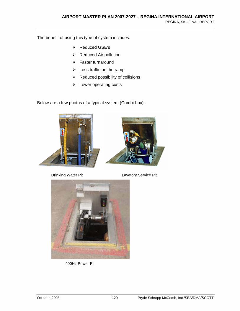
AIRPORT MASTER PLAN 2007-2027 – REGINA INTERNATIONAL AIRPORT REGINA, SK –FINAL REPORT
October, 2008 129 Pryde Schropp McComb, Inc./SEA/DMA/SCOTT
The benefit of using this type of system includes:
Reduced GSE’s
Reduced Air pollution
Faster turnaround
Less traffic on the ramp
Reduced possibility of collisions
Lower operating costs
Below are a few photos of a typical system (Combi-box):
Drinking Water Pit Lavatory Service Pit
400Hz Power Pit
AIRPORT MASTER PLAN 2007-2027 – REGINA INTERNATIONAL AIRPORT REGINA, SK – FINAL REPORT
Pryde Schropp McComb, Inc./SEA/DMA/SCOTT 130 October, 2008
Many Airports have or are considering such systems to comply with environmental regulations related to emissions and for improved operational efficiencies. This technology may be considered for future consideration at YQR as a means to improve overall air quality however, at present they are expensive and may not be economically feasible. More immediate practical initiatives that should be considered by the RAA include:
1. Continue discussions with the City of Regina to provide public transit to the airport thus reducing groundside car emissions.
2. RAA is procuring energy efficient vehicles in the upcoming year to help reduce pollution and at the same time apply for the eco rebate from the Federal Government.
3. Replacing groundside and airside light fixtures with more efficient low consumption lamps. There are existing LED technologies available for both applications.
4. Integrating power and pre-conditioned air into any new air bridges.
5. Ensuring sufficient gates are available during peak operations will reduce aircraft idling time for those waiting for the gates.
6. Provide incentives to the airlines and ground handlers to utilize electric vehicles for aircraft support and servicing.
7. Investigate and switch to cleaner burning fuels for the fire training facility.
12.5 AIRCRAFT NOISE
Canadian NEF System
The Noise Exposure Forecast (NEF) is a single number rating of overall aircraft noise used in Canada. It combines the noise levels of individual aircraft and the numbers of aircraft to give a single number rating of the average negative impact of the aircraft noise.
The Canadian Noise Exposure Forecast (NEF) was developed to encourage compatible land use planning in the vicinity of Airports. NEFs are official contours and Transport Canada will support them to the level of accuracy of the input data. The NEF has the additional benefit of providing recommended acoustic design criteria to obtain acceptable indoor noise levels for residential, commercial and other construction. The primary guiding document is TP 1247 - Land Use in the Vicinity of Airports, 8th Ed.
Table 12-1 estimates the community noise response prediction in Canada and is supported by historical scientific research performed by Transport Canada.
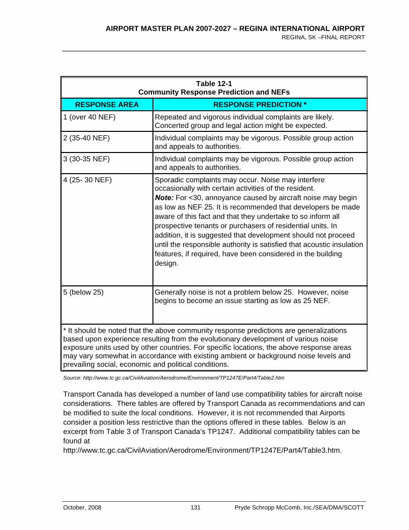
AIRPORT MASTER PLAN 2007-2027 – REGINA INTERNATIONAL AIRPORT REGINA, SK –FINAL REPORT
October, 2008 131 Pryde Schropp McComb, Inc./SEA/DMA/SCOTT
Table 12-1 Community Response Prediction and NEFs
RESPONSE AREA RESPONSE PREDICTION *1 (over 40 NEF) Repeated and vigorous individual complaints are likely.
Concerted group and legal action might be expected.
2 (35-40 NEF) Individual complaints may be vigorous. Possible group action and appeals to authorities.
3 (30-35 NEF) Individual complaints may be vigorous. Possible group action and appeals to authorities.
4 (25- 30 NEF) Sporadic complaints may occur. Noise may interfere occasionally with certain activities of the resident. Note: For <30, annoyance caused by aircraft noise may begin as low as NEF 25. It is recommended that developers be made aware of this fact and that they undertake to so inform all prospective tenants or purchasers of residential units. In addition, it is suggested that development should not proceed until the responsible authority is satisfied that acoustic insulation features, if required, have been considered in the building design.
5 (below 25) Generally noise is not a problem below 25. However, noise begins to become an issue starting as low as 25 NEF.
* It should be noted that the above community response predictions are generalizations based upon experience resulting from the evolutionary development of various noise exposure units used by other countries. For specific locations, the above response areas may vary somewhat in accordance with existing ambient or background noise levels and prevailing social, economic and political conditions.
Source: http://www.tc.gc.ca/CivilAviation/Aerodrome/Environment/TP1247E/Part4/Table2.htm
Transport Canada has developed a number of land use compatibility tables for aircraft noise considerations. There tables are offered by Transport Canada as recommendations and can be modified to suite the local conditions. However, it is not recommended that Airports consider a position less restrictive than the options offered in these tables. Below is an excerpt from Table 3 of Transport Canada’s TP1247. Additional compatibility tables can be found at http://www.tc.gc.ca/CivilAviation/Aerodrome/Environment/TP1247E/Part4/Table3.htm.
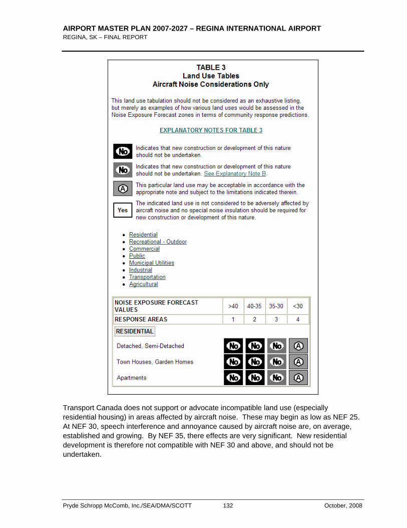
AIRPORT MASTER PLAN 2007-2027 – REGINA INTERNATIONAL AIRPORT REGINA, SK – FINAL REPORT
Pryde Schropp McComb, Inc./SEA/DMA/SCOTT 132 October, 2008
Transport Canada does not support or advocate incompatible land use (especially residential housing) in areas affected by aircraft noise. These may begin as low as NEF 25. At NEF 30, speech interference and annoyance caused by aircraft noise are, on average, established and growing. By NEF 35, there effects are very significant. New residential development is therefore not compatible with NEF 30 and above, and should not be undertaken.
AIRPORT MASTER PLAN 2007-2027 – REGINA INTERNATIONAL AIRPORT REGINA, SK –FINAL REPORT
October, 2008 133 Pryde Schropp McComb, Inc./SEA/DMA/SCOTT
Federal Recommendations Related to Aircraft Noise
Transport Canada does not support residential development inside the 30 NEF contour. In 1996 Transport Canada clarified its position on this matter and amendment applicable guidance materials. Transport Canada has further modified their position and has included the following recommendation when considering residential development and new Airports:
For new Airports, Transport Canada recommends that no new noise sensitive land uses be permitted above 25 NEF/NEP. Noise sensitive land uses include residential, schools, day care centres, nursing homes and hospitals. This approach is the single most practical for reasons of ease of implementation and administration since below this threshold, all noise-sensitive land uses would be permitted without restrictions or limitations. The guidelines for all other land uses remain unchanged from Table 3. This buffer would also offer protection against the long term uncertainties inherent in planning for a new Airport.
Health Canada continues to study the impacts of aircraft noise on humans. To date, their studies have not concluded with certainty the relationship between human health and aircraft noise. Health Canada continues to support the recommendation of Transport Canada. Additional information can be found on the Health Canada website http://www.hc-sc.gc.ca/iyh-vsv/environ/noise-bruit_e.html .
Regina Aircraft Noise Exposure Contours
The Airport Master Plan reconfirmed that validity of the 2024 NEF contours as shown in Exhibit 5 which were prepared as part of a long-term growth scenario at the airport and City of Regina. The modeling for these contours took into consideration a number of factors including air traffic growth, runway distribution, a runway extension to the north on Runway 13-31 and changes in aircraft technology anticipated in the future. This contour was ultimately approved by the RAA and the City of Regina and has been used for all long-term planning projects by the City of Regina since. Furthermore the City adopted the 30 NEF contour as the official value above which no new residential development should occur consistent with Transport Canada recommendations.
The forecasts developed in this master plan do not suggest any significant changes to these contours and the fundamental assumptions and that they should remain as the officially recognized NEF for planning by all surrounding municipalities.

AIRPORT MASTER PLAN 2007-2027 – REGINA INTERNATIONAL AIRPORT REGINA, SK – FINAL REPORT
Pryde Schropp McComb, Inc./SEA/DMA/SCOTT 134 October, 2008
12.6 SUMMARY OF KEY RECOMMENDATIONS
Based on the foregoing, the following recommendations were developed:
1. RAA should continue to support, update and practice the policies contained in their Environmental Policy documents.
2. The following represents other recommended actions that may be considered by RAA for future environmental initiatives:
a. Promote public transit to the airport to reduce groundside emissions which typically are the most significant contributor to air pollution at airports similar to YQR.
b. Replacing groundside and airside light fixtures with more efficient low consumption lamps. There are existing LED technologies available for both applications.
c. Airport operations vehicles could be converted to hybrid or fully electrical vehicles.
d. Integrating power and pre-conditioned air into any new air bridges.
e. Ensuring sufficient gates are available during peak operations will reduce aircraft idling time for those waiting for the gates.
f. Provide incentives to the airlines and ground handlers to utilize electric vehicles for aircraft support and servicing.
g. Investigate and switch to cleaner burning fuels for the fire training facility.
3. The RAA should continue to promote the use of the official 2024 Noise Exposure contour prepared in 2005 shown in Exhibit 5 by the City of Regina and the RM of Sherwood in their planning initiatives and documents.

AIRPORT MASTER PLAN 2007-2027 – REGINA INTERNATIONAL AIRPORT REGINA, SK –FINAL REPORT
October, 2008 135 Pryde Schropp McComb, Inc./SEA/DMA/SCOTT
13.0 Community Interface
13.1 COMMUNITY CONSULTATIVE COMMITTEE
The Airport’s interface with neighbours and surrounding jurisdictions is a critical part of successful airport development and operation. One of the main interfaces promoted by the RAA is the Community Consultative Committee (CCC), made up of members of the community and of the Airport Authority Board. In general, its mandate is to:
Learn and comment about airport activities and plans
Discuss operations and future planning
Share with the Authority local and municipal concerns
The Committee has 28 members who represent a cross-section of the community.
It is recommended that this Committee continue to be maintained to provide routine sharing of information and concerns.
13.2 AERONAUTICAL ZONING
Federal Airport Zoning Regulations (AZR) has been in place at the Regina Airport since 1969 and should continue to remain. The purpose of the regulations is to protect the safety of aircraft operations in the vicinity of the airport by imposing height restrictions on buildings and obstacles within defined areas. In addition, the Regulations prohibit some land uses, such as landfills, which, by attracting birds, would pose a hazard to aircraft. The existing Regina Airport Zoning Regulations, defined in the Regina Airport Zoning Plan No. E. 1746, as previously discussed in Section 2.0.
During the preparation of this Airport Master Plan, a conflict was identified with the current AZR and Courtney St. Figure 13-1 shows how the AZR crosses over the existing road right-of-way. This overlap may require some revisions to the future Courtney Street improvements and should be reviewed with the City in the near-term.
13.3 MUNICIPAL INTERFACE
Regina City Land Use Planning
The City of Regina has been careful to embody aircraft noise factors into development plans. City By-laws have been enacted to prohibit any new residential development in areas where noise exposure levels are NEF 30 or higher. The set of contours used to benchmark the by-law is the updated 2024 NEF contours shown in Exhibit 5.
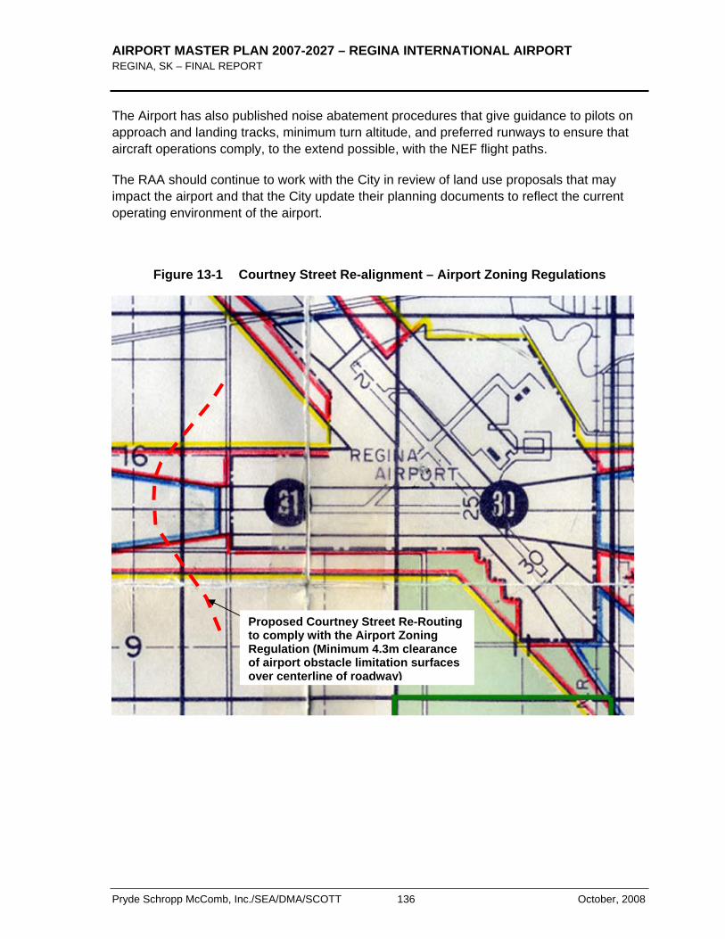
AIRPORT MASTER PLAN 2007-2027 – REGINA INTERNATIONAL AIRPORT REGINA, SK – FINAL REPORT
Pryde Schropp McComb, Inc./SEA/DMA/SCOTT 136 October, 2008
The Airport has also published noise abatement procedures that give guidance to pilots on approach and landing tracks, minimum turn altitude, and preferred runways to ensure that aircraft operations comply, to the extend possible, with the NEF flight paths.
The RAA should continue to work with the City in review of land use proposals that may impact the airport and that the City update their planning documents to reflect the current operating environment of the airport.
Figure 13-1 Courtney Street Re-alignment – Airport Zoning Regulations
Proposed Courtney Street Re-Routing to comply with the Airport Zoning Regulation (Minimum 4.3m clearance of airport obstacle limitation surfaces over centerline of roadway)

AIRPORT MASTER PLAN 2007-2027 – REGINA INTERNATIONAL AIRPORT REGINA, SK –FINAL REPORT
October, 2008 137 Pryde Schropp McComb, Inc./SEA/DMA/SCOTT
Rural Municipality (RM) of Sherwood
The RM Sherwood has representation on the RAA Board and at the time of finalizing this Airport Master Plan the RM was in the process of updating their planning documents. It is recommended that this Airport Master Plan be used as reference document including special attention to incorporating the 2024 NEF contour similar to the City of Regina.
13.4 SUMMARY OF KEY RECOMMENDATIONS:
1. The RAA should promote the update of the City of Regina’s Zoning Bylaw and other related documents to reflect the current status of the airport. Various sections of these documents still refer to Transport Canada as the airport operator versus the RAA.
2. The RM Sherwood is currently updating their land use documents. It is recommended that the Airport Master Plan 2024 NEF contours be integrated and recognized in these updates.
3. The RAA should continue to foster cooperative relationships with the surrounding municipalities including the City of Regina and RM Sherwood.

AIRPORT MASTER PLAN 2007-2027 – REGINA INTERNATIONAL AIRPORT REGINA, SK – FINAL REPORT
Pryde Schropp McComb, Inc./SEA/DMA/SCOTT 138 October, 2008
< THIS PAGE LEFT INTENTIONALLY BLANK >
AIRPORT MASTER PLAN 2007-2027 – REGINA INTERNATIONAL AIRPORT REGINA, SK –FINAL REPORT
October, 2008 139 Pryde Schropp McComb, Inc./SEA/DMA/SCOTT
14.0 Airport Land Use Plan 2027
14.1 GENERAL
One of the main objectives of the Airport Master Plan is to provide guidance for future land development. The purpose of this section is to integrate the requirements and synthesize the recommendations derived from the analysis undertaken in the previous sections. The results are the Airport Development Concept Plan (Exhibit 7) and the 2027 Airport Land Use Plan (Exhibit 13).
14.2 GUIDING PRINCIPLES
The Airport Land Use Plan places existing Airport infrastructure and land reserves in the context of the current operating and market environment at the Regina International Airport, and establishes an approach to meet forecast requirements for the next 20 years. The planning principles used as a basis for land use designations reflect the Strategic Objectives and development targets of RAA, as presented throughout this report. Specifically, the key principles for land use planning aim to:
1. Protect existing operations areas and provide for airfield expansion requirements that may occur over the long-term and beyond the planning horizon;
2. Designate sufficient land to permit expansion of passenger facilities and related services;
3. Facilitate commercial development strategies through flexible commercial land use designations; and
4. Undertake development in a manner that will protect or enhance environmental conditions on the Airport and for the community at large.
14.3 AIRPORT DEVELOPMENT CONCEPT PLAN 2027
The Airport Development Concept Plan summarizes the entire Master Planning recommendations for expansion and future development of Airport facilities. This Development Concept Plan illustrates planned infrastructure development and key activity areas to 2027 and is intended to provide more specific direction with respect to Airport development strategies and commercial opportunities.
The Development Concept Plan is arranged in predominant activity areas. These designations complement land uses by identifying the predominant nature of activities best accommodated in each of the Airport’s development areas. The concept of predominant activities is introduced solely for the purpose of guiding development strategies and is not intended to exclude other types of development from occurring in each area.
AIRPORT MASTER PLAN 2007-2027 – REGINA INTERNATIONAL AIRPORT REGINA, SK – FINAL REPORT
Pryde Schropp McComb, Inc./SEA/DMA/SCOTT 140 October, 2008
The 2027 Airport Development Concept Plan is presented in Exhibit 7.
14.4 REGINA INTERNATIONAL AIRPORT LAND USE PLAN 2027
The 2027 Airport Land Use Plan is shown in Exhibit 13. The existing land use pattern has changed somewhat but not significantly from the 2021 Airport Land Use Plan.
This proposed Airport Land Use Plan retains airport land use terminology consistent with the Transport Canada Ground Lease Agreement.
The airside system continues to protect the extension of the runway towards the north and all the areas under the runway approaches. This reserve also incorporates protection areas for associated airfield navigational aids and future requirements for runway end safety areas (RESA). Furthermore, the airside system also protects for Apron I expansion to the north and east including provisions for remote parking and a future central de-icing facility. Included in this reserve are also future cargo aprons and airside access to commercial development lots.
In light of the Air Terminal Building’s long-term expansion requirements, the Air Terminal Reserve has been expanded to the north and east. The new reserve will provide sufficient area to accommodate Air Terminal expansion and the long-term potential for a full re-reconstruction should it be required sometime beyond the planning period.
Sufficient space has also been reserved for Groundside Access and Parking to ensure expansion capability, without limiting design flexibility in further planning stages.
Commercial development areas are preserved and re-defined to reflect the commercial land use designations compatible with the Transport Canada Ground Lease. While infilling remains available in the existing commercial development area, new sites have been reserved at the north end of the site and south of Regina Avenue. These new sites give the RAA and opportunity to create their own unique development concept without being limited to existing development patterns inherited from Transport Canada at the time of transfer in 1999.
Tables 14-1 and 14-2 provide a description of the various land use plan elements and areas associated with Exhibit 13.
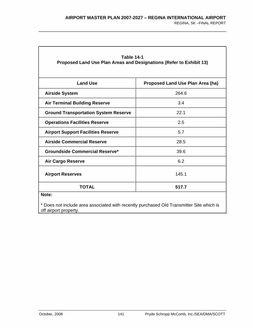
AIRPORT MASTER PLAN 2007-2027 – REGINA INTERNATIONAL AIRPORT REGINA, SK –FINAL REPORT
October, 2008 141 Pryde Schropp McComb, Inc./SEA/DMA/SCOTT
Table 14-1 Proposed Land Use Plan Areas and Designations (Refer to Exhibit 13)
Land Use Proposed Land Use Plan Area (ha)
Airside System 264.6
Air Terminal Building Reserve 3.4
Ground Transportation System Reserve 22.1
Operations Facilities Reserve 2.5
Airport Support Facilities Reserve 5.7
Airside Commercial Reserve 28.5
Groundside Commercial Reserve* 39.6
Air Cargo Reserve 6.2
Airport Reserves 145.1
TOTAL 517.7 Note:
* Does not include area associated with recently purchased Old Transmitter Site which is off airport property.
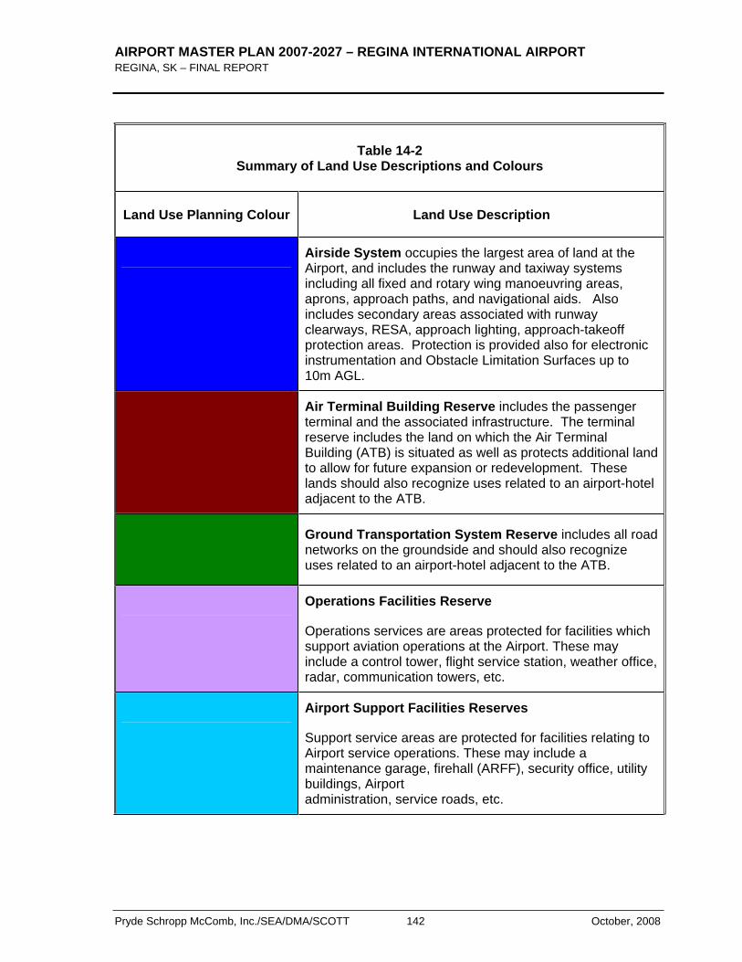
AIRPORT MASTER PLAN 2007-2027 – REGINA INTERNATIONAL AIRPORT REGINA, SK – FINAL REPORT
Pryde Schropp McComb, Inc./SEA/DMA/SCOTT 142 October, 2008
Table 14-2 Summary of Land Use Descriptions and Colours
Land Use Planning Colour Land Use Description
Airside System occupies the largest area of land at the Airport, and includes the runway and taxiway systems including all fixed and rotary wing manoeuvring areas, aprons, approach paths, and navigational aids. Also includes secondary areas associated with runway clearways, RESA, approach lighting, approach-takeoff protection areas. Protection is provided also for electronic instrumentation and Obstacle Limitation Surfaces up to 10m AGL.
Air Terminal Building Reserve includes the passenger terminal and the associated infrastructure. The terminal reserve includes the land on which the Air Terminal Building (ATB) is situated as well as protects additional land to allow for future expansion or redevelopment. These lands should also recognize uses related to an airport-hotel adjacent to the ATB.
Ground Transportation System Reserve includes all road networks on the groundside and should also recognize uses related to an airport-hotel adjacent to the ATB.
Operations Facilities Reserve
Operations services are areas protected for facilities which support aviation operations at the Airport. These may include a control tower, flight service station, weather office, radar, communication towers, etc.
Airport Support Facilities Reserves
Support service areas are protected for facilities relating to Airport service operations. These may include a maintenance garage, firehall (ARFF), security office, utility buildings, Airportadministration, service roads, etc.
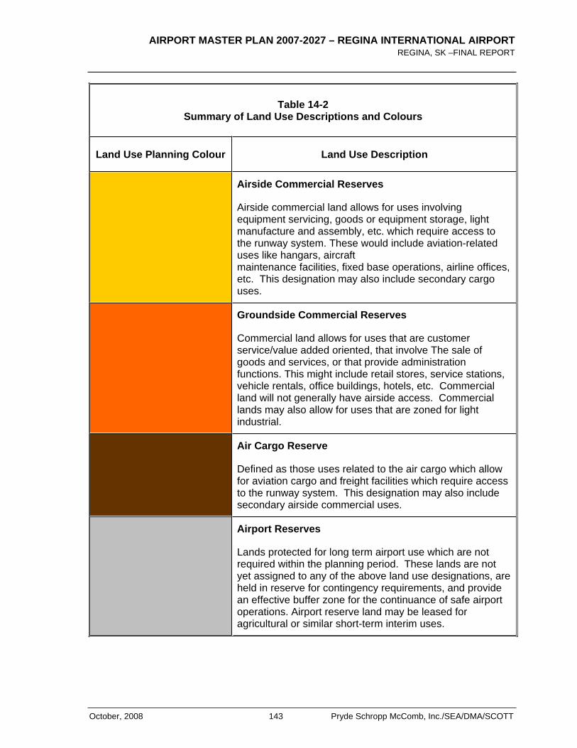
AIRPORT MASTER PLAN 2007-2027 – REGINA INTERNATIONAL AIRPORT REGINA, SK –FINAL REPORT
October, 2008 143 Pryde Schropp McComb, Inc./SEA/DMA/SCOTT
Table 14-2 Summary of Land Use Descriptions and Colours
Land Use Planning Colour Land Use Description
Airside Commercial Reserves
Airside commercial land allows for uses involving equipment servicing, goods or equipment storage, light manufacture and assembly, etc. which require access to the runway system. These would include aviation-related uses like hangars, aircraft maintenance facilities, fixed base operations, airline offices, etc. This designation may also include secondary cargo uses.
Groundside Commercial Reserves
Commercial land allows for uses that are customer service/value added oriented, that involve The sale of goods and services, or that provide administration functions. This might include retail stores, service stations, vehicle rentals, office buildings, hotels, etc. Commercial land will not generally have airside access. Commercial lands may also allow for uses that are zoned for light industrial.
Air Cargo Reserve
Defined as those uses related to the air cargo which allow for aviation cargo and freight facilities which require access to the runway system. This designation may also include secondary airside commercial uses.
Airport Reserves
Lands protected for long term airport use which are not required within the planning period. These lands are not yet assigned to any of the above land use designations, are held in reserve for contingency requirements, and provide an effective buffer zone for the continuance of safe airport operations. Airport reserve land may be leased for agricultural or similar short-term interim uses.
AIRPORT MASTER PLAN 2007-2027 – REGINA INTERNATIONAL AIRPORT REGINA, SK – FINAL REPORT
Pryde Schropp McComb, Inc./SEA/DMA/SCOTT 144 October, 2008
< THIS PAGE LEFT INTENTIONALLY BLANK >
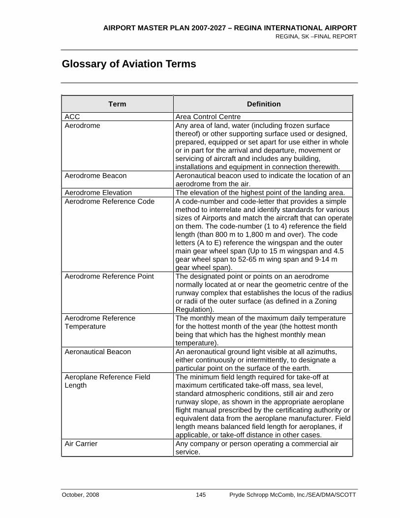
AIRPORT MASTER PLAN 2007-2027 – REGINA INTERNATIONAL AIRPORT REGINA, SK –FINAL REPORT
October, 2008 145 Pryde Schropp McComb, Inc./SEA/DMA/SCOTT
Glossary of Aviation Terms
Term Definition
ACC Area Control Centre Aerodrome Any area of land, water (including frozen surface
thereof) or other supporting surface used or designed, prepared, equipped or set apart for use either in whole or in part for the arrival and departure, movement or servicing of aircraft and includes any building, installations and equipment in connection therewith.
Aerodrome Beacon Aeronautical beacon used to indicate the location of an aerodrome from the air.
Aerodrome Elevation The elevation of the highest point of the landing area. Aerodrome Reference Code A code-number and code-letter that provides a simple
method to interrelate and identify standards for various sizes of Airports and match the aircraft that can operate on them. The code-number (1 to 4) reference the field length (than 800 m to 1,800 m and over). The code letters (A to E) reference the wingspan and the outer main gear wheel span (Up to 15 m wingspan and 4.5 gear wheel span to 52-65 m wing span and 9-14 m gear wheel span).
Aerodrome Reference Point The designated point or points on an aerodrome normally located at or near the geometric centre of the runway complex that establishes the locus of the radius or radii of the outer surface (as defined in a Zoning Regulation).
Aerodrome Reference Temperature
The monthly mean of the maximum daily temperature for the hottest month of the year (the hottest month being that which has the highest monthly mean temperature).
Aeronautical Beacon An aeronautical ground light visible at all azimuths, either continuously or intermittently, to designate a particular point on the surface of the earth.
Aeroplane Reference Field Length
The minimum field length required for take-off at maximum certificated take-off mass, sea level, standard atmospheric conditions, still air and zero runway slope, as shown in the appropriate aeroplane flight manual prescribed by the certificating authority or equivalent data from the aeroplane manufacturer. Field length means balanced field length for aeroplanes, if applicable, or take-off distance in other cases.
Air Carrier Any company or person operating a commercial air service.

AIRPORT MASTER PLAN 2007-2027 – REGINA INTERNATIONAL AIRPORT REGINA, SK – FINAL REPORT
Pryde Schropp McComb, Inc./SEA/DMA/SCOTT 146 October, 2008
Term Definition
Air Terminal Building (ATB) An installation provided with the facilities for loading and unloading aircraft and the intransit handling of traffic (passengers, cargo and mail) which is moved by aircraft.
Air Traffic All aircraft in flight and aircraft on the manoeuvring area of an aerodrome.
Air Traffic Control (ATC) A service as specified in Part VI of the Air Regulations provided for the purposes of preventing collisions between aircraft, and on the manoeuvring area between aircraft and obstructions, and expediting and maintaining an orderly flow of air traffic.
Air Traffic Control Tower A facility established on an Airport to provide air traffic control services on and in the vicinity of that Airport; a structure containing facilities for the control of Airport traffic, including the movement of aircraft, vehicles and pedestrians in the manoeuvring areas, as well as aircraft in flight. This structure may be associated with an Air Terminal Building or an operational building or it may be a freestanding structure.
Aircraft A machine capable of deriving support in the atmosphere from the reactions of the air
Aircraft Mix The various types of aircraft operating at an Airport or in a region. Generally classified on the basis of weight and engine type. Category:
Light – 0 to 12,499 lbs. (e.g. Cessna 402) Medium – 12,500 to 299,999 (e.g. Airbus A320) Heavy – over 300,000 (e.g. Boeing B767)
Aircraft Movement Take-off, landing, or simulated approach by an aircraft.Itinerant movement Movements proceeding to or arriving from another location; or leaves the aerodrome traffic circuit but will be returning to land. Includes all fixed wing runway movements and helicopter operations. Excludes flights only passing through the control zone of the Airport in question. Local movement Local aircraft are considered as aircraft which remain in the circuit or in the vicinity of the Airport and will return to the Airport.
Aircraft Stand A designated area on an apron intended to be used for parking an aircraft.
Aircraft Stand Taxilane A portion of an apron designated as a taxiway and intended to provide access to aircraft stands only.
Airport An aerodrome for which an Airport certificate is in force.
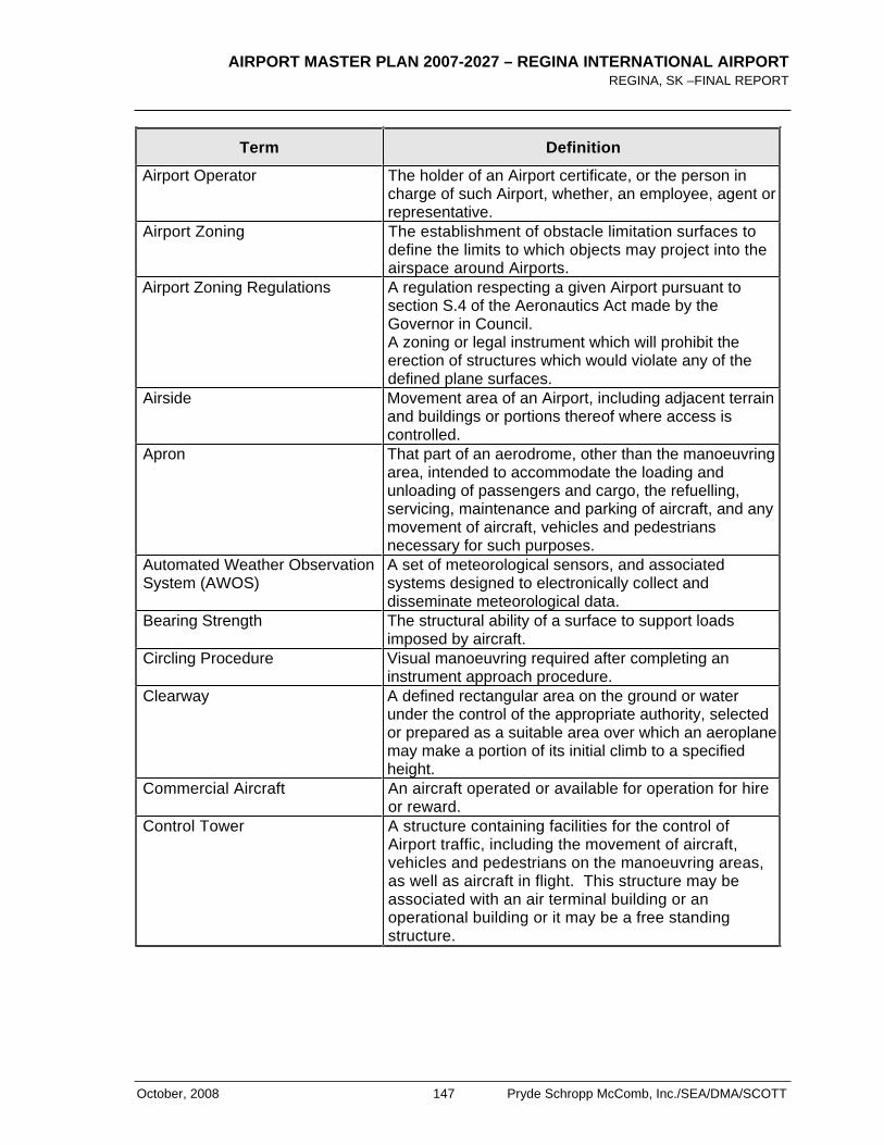
AIRPORT MASTER PLAN 2007-2027 – REGINA INTERNATIONAL AIRPORT REGINA, SK –FINAL REPORT
October, 2008 147 Pryde Schropp McComb, Inc./SEA/DMA/SCOTT
Term Definition
Airport Operator The holder of an Airport certificate, or the person in charge of such Airport, whether, an employee, agent or representative.
Airport Zoning The establishment of obstacle limitation surfaces to define the limits to which objects may project into the airspace around Airports.
Airport Zoning Regulations A regulation respecting a given Airport pursuant to section S.4 of the Aeronautics Act made by the Governor in Council. A zoning or legal instrument which will prohibit the erection of structures which would violate any of the defined plane surfaces.
Airside Movement area of an Airport, including adjacent terrain and buildings or portions thereof where access is controlled.
Apron That part of an aerodrome, other than the manoeuvring area, intended to accommodate the loading and unloading of passengers and cargo, the refuelling, servicing, maintenance and parking of aircraft, and any movement of aircraft, vehicles and pedestrians necessary for such purposes.
Automated Weather Observation System (AWOS)
A set of meteorological sensors, and associated systems designed to electronically collect and disseminate meteorological data.
Bearing Strength The structural ability of a surface to support loads imposed by aircraft.
Circling Procedure Visual manoeuvring required after completing an instrument approach procedure.
Clearway A defined rectangular area on the ground or water under the control of the appropriate authority, selected or prepared as a suitable area over which an aeroplane may make a portion of its initial climb to a specified height.
Commercial Aircraft An aircraft operated or available for operation for hire or reward.
Control Tower A structure containing facilities for the control of Airport traffic, including the movement of aircraft, vehicles and pedestrians on the manoeuvring areas, as well as aircraft in flight. This structure may be associated with an air terminal building or an operational building or it may be a free standing structure.
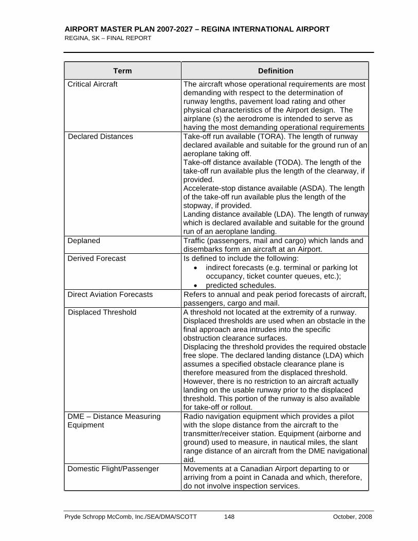
AIRPORT MASTER PLAN 2007-2027 – REGINA INTERNATIONAL AIRPORT REGINA, SK – FINAL REPORT
Pryde Schropp McComb, Inc./SEA/DMA/SCOTT 148 October, 2008
Term Definition
Critical Aircraft The aircraft whose operational requirements are most demanding with respect to the determination of runway lengths, pavement load rating and other physical characteristics of the Airport design. The airplane (s) the aerodrome is intended to serve as having the most demanding operational requirements
Declared Distances Take-off run available (TORA). The length of runway declared available and suitable for the ground run of an aeroplane taking off. Take-off distance available (TODA). The length of the take-off run available plus the length of the clearway, if provided.Accelerate-stop distance available (ASDA). The length of the take-off run available plus the length of the stopway, if provided. Landing distance available (LDA). The length of runway which is declared available and suitable for the ground run of an aeroplane landing.
Deplaned Traffic (passengers, mail and cargo) which lands and disembarks form an aircraft at an Airport.
Derived Forecast Is defined to include the following: indirect forecasts (e.g. terminal or parking lot
occupancy, ticket counter queues, etc.); predicted schedules.
Direct Aviation Forecasts Refers to annual and peak period forecasts of aircraft, passengers, cargo and mail.
Displaced Threshold A threshold not located at the extremity of a runway. Displaced thresholds are used when an obstacle in the final approach area intrudes into the specific obstruction clearance surfaces. Displacing the threshold provides the required obstacle free slope. The declared landing distance (LDA) which assumes a specified obstacle clearance plane is therefore measured from the displaced threshold. However, there is no restriction to an aircraft actually landing on the usable runway prior to the displaced threshold. This portion of the runway is also available for take-off or rollout.
DME – Distance Measuring Equipment
Radio navigation equipment which provides a pilot with the slope distance from the aircraft to the transmitter/receiver station. Equipment (airborne and ground) used to measure, in nautical miles, the slant range distance of an aircraft from the DME navigational aid.
Domestic Flight/Passenger Movements at a Canadian Airport departing to or arriving from a point in Canada and which, therefore, do not involve inspection services.
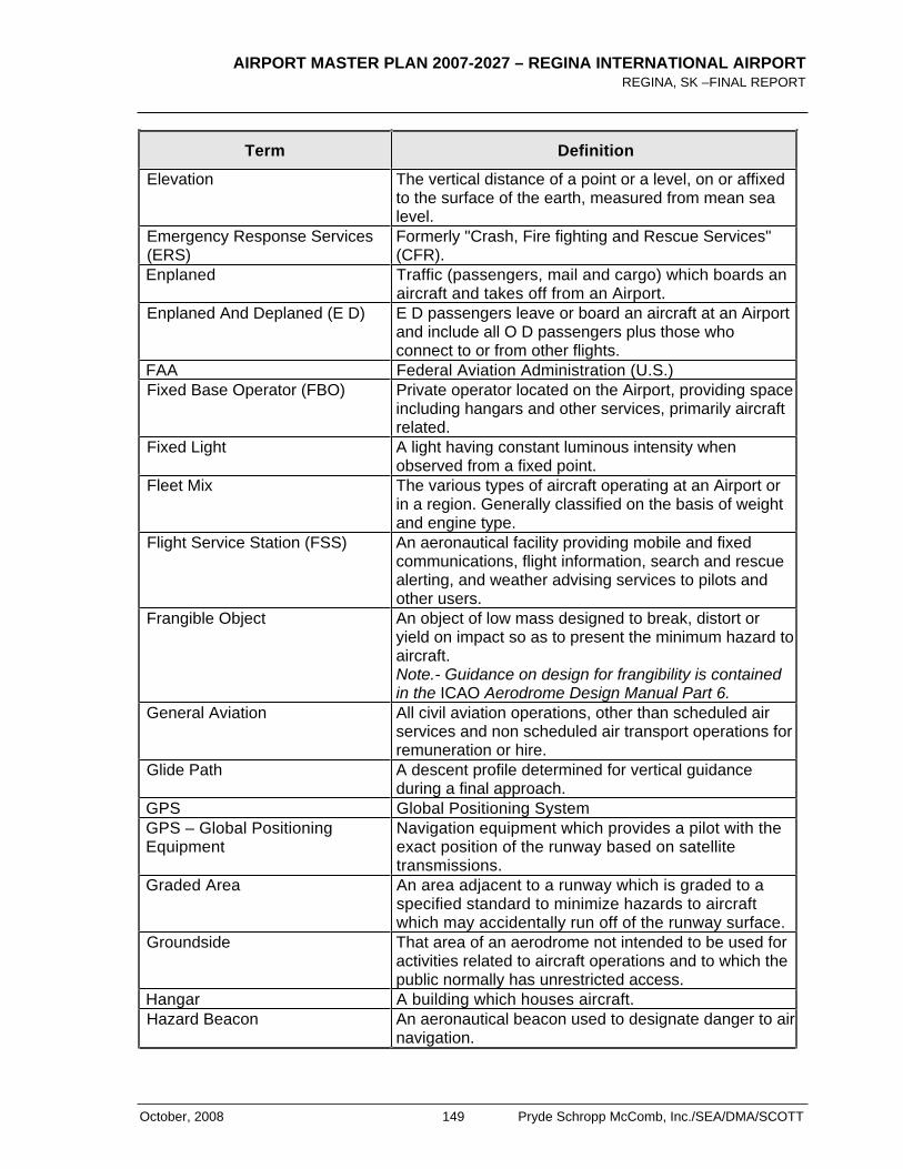
AIRPORT MASTER PLAN 2007-2027 – REGINA INTERNATIONAL AIRPORT REGINA, SK –FINAL REPORT
October, 2008 149 Pryde Schropp McComb, Inc./SEA/DMA/SCOTT
Term Definition
Elevation The vertical distance of a point or a level, on or affixed to the surface of the earth, measured from mean sea level.
Emergency Response Services (ERS)
Formerly "Crash, Fire fighting and Rescue Services" (CFR).
Enplaned Traffic (passengers, mail and cargo) which boards an aircraft and takes off from an Airport.
Enplaned And Deplaned (E D) E D passengers leave or board an aircraft at an Airport and include all O D passengers plus those who connect to or from other flights.
FAA Federal Aviation Administration (U.S.) Fixed Base Operator (FBO) Private operator located on the Airport, providing space
including hangars and other services, primarily aircraft related.
Fixed Light A light having constant luminous intensity when observed from a fixed point.
Fleet Mix The various types of aircraft operating at an Airport or in a region. Generally classified on the basis of weight and engine type.
Flight Service Station (FSS) An aeronautical facility providing mobile and fixed communications, flight information, search and rescue alerting, and weather advising services to pilots and other users.
Frangible Object An object of low mass designed to break, distort or yield on impact so as to present the minimum hazard to aircraft.Note.- Guidance on design for frangibility is contained in the ICAO Aerodrome Design Manual Part 6.
General Aviation All civil aviation operations, other than scheduled air services and non scheduled air transport operations for remuneration or hire.
Glide Path A descent profile determined for vertical guidance during a final approach.
GPS Global Positioning System GPS – Global Positioning Equipment
Navigation equipment which provides a pilot with the exact position of the runway based on satellite transmissions.
Graded Area An area adjacent to a runway which is graded to a specified standard to minimize hazards to aircraft which may accidentally run off of the runway surface.
Groundside That area of an aerodrome not intended to be used for activities related to aircraft operations and to which the public normally has unrestricted access.
Hangar A building which houses aircraft. Hazard Beacon An aeronautical beacon used to designate danger to air
navigation.
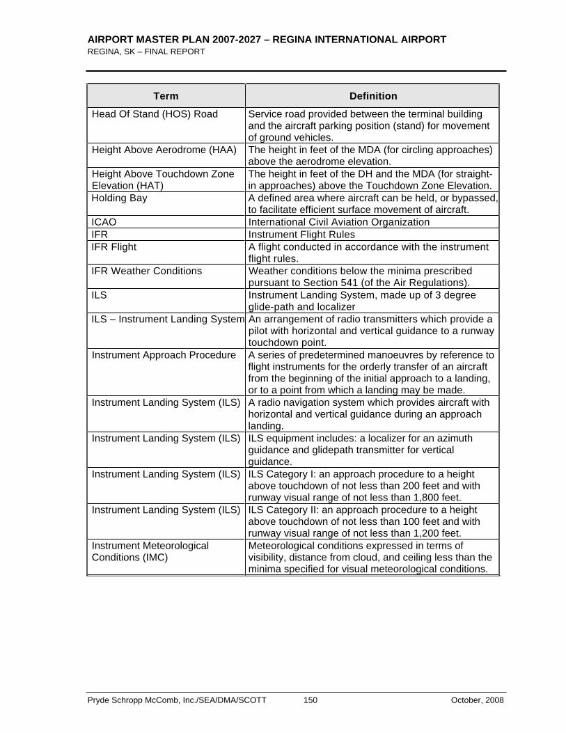
AIRPORT MASTER PLAN 2007-2027 – REGINA INTERNATIONAL AIRPORT REGINA, SK – FINAL REPORT
Pryde Schropp McComb, Inc./SEA/DMA/SCOTT 150 October, 2008
Term Definition
Head Of Stand (HOS) Road Service road provided between the terminal building and the aircraft parking position (stand) for movement of ground vehicles.
Height Above Aerodrome (HAA) The height in feet of the MDA (for circling approaches) above the aerodrome elevation.
Height Above Touchdown Zone Elevation (HAT)
The height in feet of the DH and the MDA (for straight-in approaches) above the Touchdown Zone Elevation.
Holding Bay A defined area where aircraft can be held, or bypassed, to facilitate efficient surface movement of aircraft.
ICAO International Civil Aviation Organization IFR Instrument Flight Rules IFR Flight A flight conducted in accordance with the instrument
flight rules. IFR Weather Conditions Weather conditions below the minima prescribed
pursuant to Section 541 (of the Air Regulations). ILS Instrument Landing System, made up of 3 degree
glide-path and localizer ILS – Instrument Landing System An arrangement of radio transmitters which provide a
pilot with horizontal and vertical guidance to a runway touchdown point.
Instrument Approach Procedure A series of predetermined manoeuvres by reference to flight instruments for the orderly transfer of an aircraft from the beginning of the initial approach to a landing, or to a point from which a landing may be made.
Instrument Landing System (ILS) A radio navigation system which provides aircraft with horizontal and vertical guidance during an approach landing.
Instrument Landing System (ILS) ILS equipment includes: a localizer for an azimuth guidance and glidepath transmitter for vertical guidance.
Instrument Landing System (ILS) ILS Category I: an approach procedure to a height above touchdown of not less than 200 feet and with runway visual range of not less than 1,800 feet.
Instrument Landing System (ILS) ILS Category II: an approach procedure to a height above touchdown of not less than 100 feet and with runway visual range of not less than 1,200 feet.
Instrument Meteorological Conditions (IMC)
Meteorological conditions expressed in terms of visibility, distance from cloud, and ceiling less than the minima specified for visual meteorological conditions.
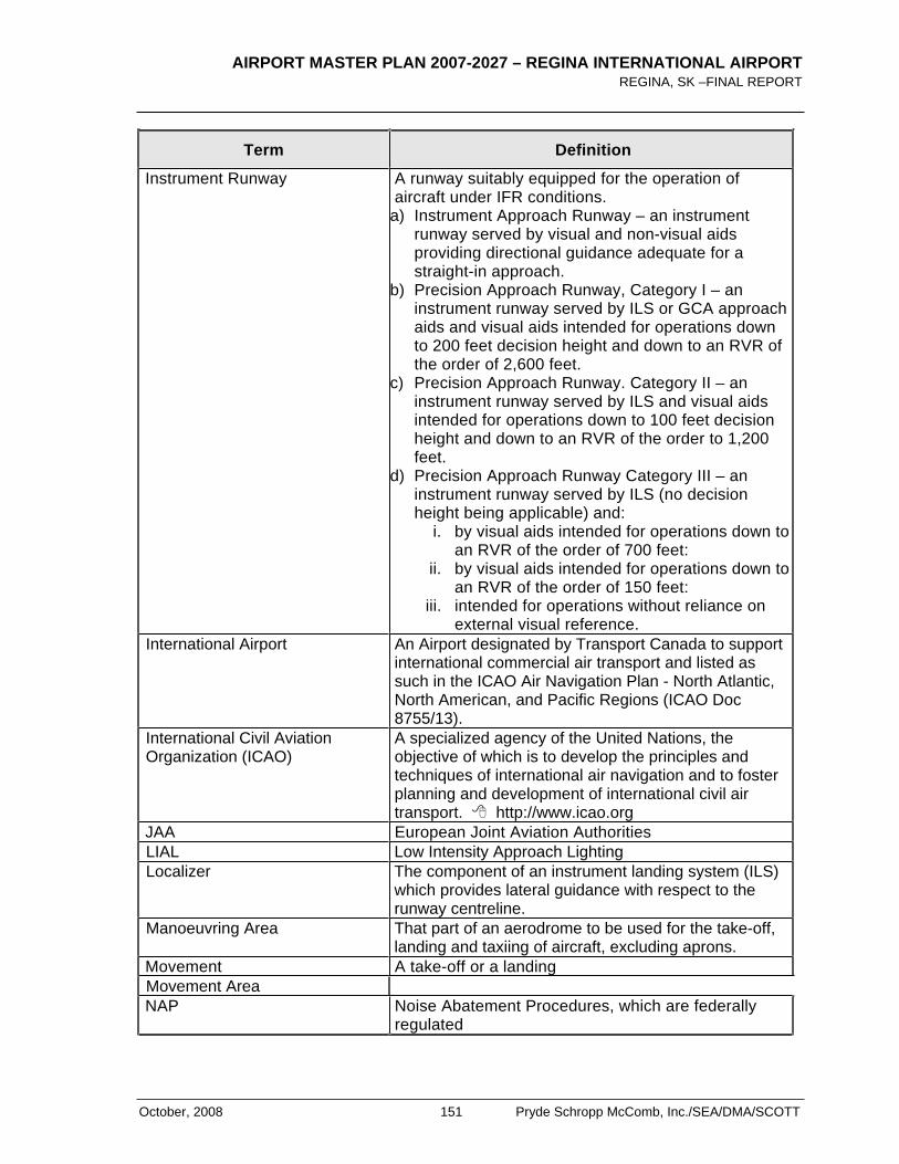
AIRPORT MASTER PLAN 2007-2027 – REGINA INTERNATIONAL AIRPORT REGINA, SK –FINAL REPORT
October, 2008 151 Pryde Schropp McComb, Inc./SEA/DMA/SCOTT
Term Definition
Instrument Runway A runway suitably equipped for the operation of aircraft under IFR conditions.
a) Instrument Approach Runway – an instrument runway served by visual and non-visual aids providing directional guidance adequate for a straight-in approach.
b) Precision Approach Runway, Category I – an instrument runway served by ILS or GCA approach aids and visual aids intended for operations down to 200 feet decision height and down to an RVR of the order of 2,600 feet.
c) Precision Approach Runway. Category II – an instrument runway served by ILS and visual aids intended for operations down to 100 feet decision height and down to an RVR of the order to 1,200 feet.
d) Precision Approach Runway Category III – an instrument runway served by ILS (no decision height being applicable) and:
i. by visual aids intended for operations down to an RVR of the order of 700 feet:
ii. by visual aids intended for operations down to an RVR of the order of 150 feet:
iii. intended for operations without reliance on external visual reference.
International Airport An Airport designated by Transport Canada to support international commercial air transport and listed as such in the ICAO Air Navigation Plan - North Atlantic, North American, and Pacific Regions (ICAO Doc 8755/13).
International Civil Aviation Organization (ICAO)
A specialized agency of the United Nations, the objective of which is to develop the principles and techniques of international air navigation and to foster planning and development of international civil air transport. http://www.icao.org
JAA European Joint Aviation Authorities LIAL Low Intensity Approach Lighting Localizer The component of an instrument landing system (ILS)
which provides lateral guidance with respect to the runway centreline.
Manoeuvring Area That part of an aerodrome to be used for the take-off, landing and taxiing of aircraft, excluding aprons.
Movement A take-off or a landing Movement Area NAP Noise Abatement Procedures, which are federally
regulated
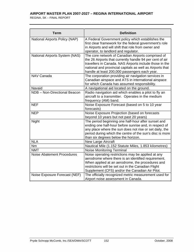
AIRPORT MASTER PLAN 2007-2027 – REGINA INTERNATIONAL AIRPORT REGINA, SK – FINAL REPORT
Pryde Schropp McComb, Inc./SEA/DMA/SCOTT 152 October, 2008
Term Definition
National Airports Policy (NAP) A Federal Government policy which establishes the first clear framework for the federal government's role in Airports and will shift that role from owner and operator, to landlord and regulator.
National Airports System (NAS) The core network of Canadian Airports comprised of the 26 Airports that currently handle 94 per cent of air travellers in Canada. NAS Airports include those in the national and provincial capitals as well as Airports that handle at least 200,000 passengers each year.
NAV Canada The corporation providing air navigation services in Canadian airspace and ATS in international airspace for which Canada has assumed responsibility.
Navaid A navigational aid located on the ground. NDB – Non-Directional Beacon Radio navigation aid which enables a pilot to fly an
aircraft to a transmitter. Operates in the medium frequency (AM) band.
NEF Noise Exposure Forecast (based on 5 to 10 year forecasts)
NEP Noise Exposure Projection (based on forecasts beyond 10 years but not past 20 years)
Night The period beginning one half-hour after sunset and ending one half-hour before sunrise and, in respect of any place where the sun does not rise or set daily, the period during which the centre of the sun's disc is more than six degrees below the horizon.
NLA New Large Aircraft Nm Nautical Mile (1.152 Statute Miles, 1.853 kilometres) NMT Noise Monitoring Terminal Noise Abatement Procedures Noise operating restrictions may be applied at any
aerodrome where there is an identified requirement. When applied at an aerodrome, the procedures and restrictions will be set out in the Canadian Flight Supplement (CFS) and/or the Canadian Air Pilot.
Noise Exposure Forecast (NEF) The officially recognized metric measurement used for Airport noise assessment in Canada.
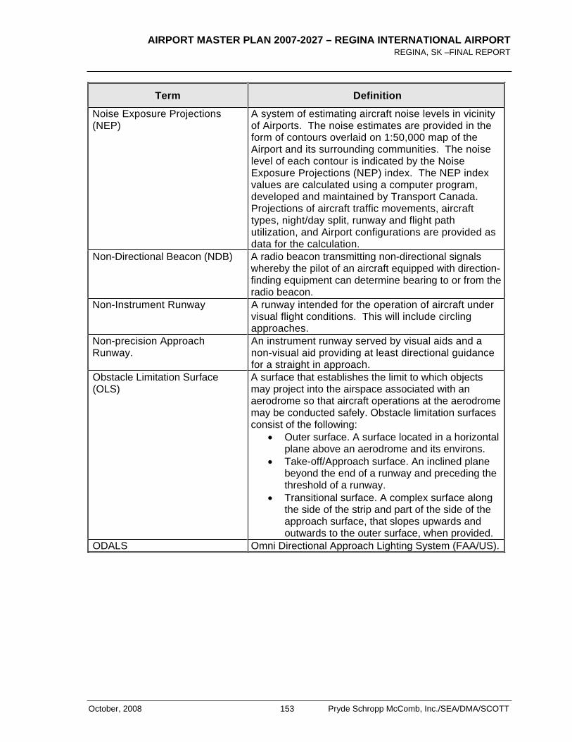
AIRPORT MASTER PLAN 2007-2027 – REGINA INTERNATIONAL AIRPORT REGINA, SK –FINAL REPORT
October, 2008 153 Pryde Schropp McComb, Inc./SEA/DMA/SCOTT
Term Definition
Noise Exposure Projections (NEP)
A system of estimating aircraft noise levels in vicinity of Airports. The noise estimates are provided in the form of contours overlaid on 1:50,000 map of the Airport and its surrounding communities. The noise level of each contour is indicated by the Noise Exposure Projections (NEP) index. The NEP index values are calculated using a computer program, developed and maintained by Transport Canada. Projections of aircraft traffic movements, aircraft types, night/day split, runway and flight path utilization, and Airport configurations are provided as data for the calculation.
Non-Directional Beacon (NDB) A radio beacon transmitting non-directional signals whereby the pilot of an aircraft equipped with direction-finding equipment can determine bearing to or from the radio beacon.
Non-Instrument Runway A runway intended for the operation of aircraft under visual flight conditions. This will include circling approaches.
Non-precision Approach Runway.
An instrument runway served by visual aids and a non-visual aid providing at least directional guidance for a straight in approach.
Obstacle Limitation Surface (OLS)
A surface that establishes the limit to which objects may project into the airspace associated with an aerodrome so that aircraft operations at the aerodrome may be conducted safely. Obstacle limitation surfaces consist of the following:
Outer surface. A surface located in a horizontal plane above an aerodrome and its environs.
Take-off/Approach surface. An inclined plane beyond the end of a runway and preceding the threshold of a runway.
Transitional surface. A complex surface along the side of the strip and part of the side of the approach surface, that slopes upwards and outwards to the outer surface, when provided.
ODALS Omni Directional Approach Lighting System (FAA/US).
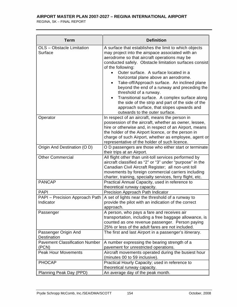
AIRPORT MASTER PLAN 2007-2027 – REGINA INTERNATIONAL AIRPORT REGINA, SK – FINAL REPORT
Pryde Schropp McComb, Inc./SEA/DMA/SCOTT 154 October, 2008
Term Definition
OLS – Obstacle Limitation Surface
A surface that establishes the limit to which objects may project into the airspace associated with an aerodrome so that aircraft operations may be conducted safely. Obstacle limitation surfaces consist of the following:
Outer surface. A surface located in a horizontal plane above an aerodrome.
Take-off/Approach surface. An inclined plane beyond the end of a runway and preceding the threshold of a runway.
Transitional surface. A complex surface along the side of the strip and part of the side of the approach surface, that slopes upwards and outwards to the outer surface.
Operator In respect of an aircraft, means the person in possession of the aircraft, whether as owner, lessee, hire or otherwise and, in respect of an Airport, means the holder of the Airport licence, or the person in charge of such Airport, whether as employee, agent or representative of the holder of such licence.
Origin And Destination (O D) O D passengers are those who either start or terminate their trips at an Airport.
Other Commercial All flight other than unit-toll services performed by aircraft classified as “2” or “3” under “purpose” in the Canadian Civil Aircraft Register; all non-unit toll movements by foreign commercial carriers including charter, training, specialty services, ferry flight, etc.
PANCAP Practical Annual Capacity, used in reference to theoretical runway capacity.
PAPI Precision Approach Path Indicator PAPI – Precision Approach Path Indicator
A set of lights near the threshold of a runway to provide the pilot with an indication of the correct approach.
Passenger A person, who pays a fare and receives air transportation, including a free baggage allowance, is counted as one revenue passenger. Person paying 25% or less of the adult fares are not included.
Passenger Origin And Destination
The first and last Airport in a passenger’s itinerary.
Pavement Classification Number (PCN)
A number expressing the bearing strength of a pavement for unrestricted operations.
Peak Hour Movements Aircraft movements operated during the busiest hour (minutes 00 to 59 inclusive).
PHOCAP Practical Hourly Capacity; used in reference to theoretical runway capacity.
Planning Peak Day (PPD) An average day of the peak month.
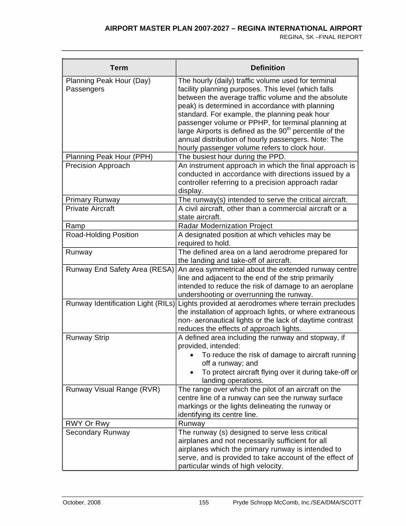
AIRPORT MASTER PLAN 2007-2027 – REGINA INTERNATIONAL AIRPORT REGINA, SK –FINAL REPORT
October, 2008 155 Pryde Schropp McComb, Inc./SEA/DMA/SCOTT
Term Definition
Planning Peak Hour (Day) Passengers
The hourly (daily) traffic volume used for terminal facility planning purposes. This level (which falls between the average traffic volume and the absolute peak) is determined in accordance with planning standard. For example, the planning peak hour passenger volume or PPHP, for terminal planning at large Airports is defined as the 90th percentile of the annual distribution of hourly passengers. Note: The hourly passenger volume refers to clock hour.
Planning Peak Hour (PPH) The busiest hour during the PPD. Precision Approach An instrument approach in which the final approach is
conducted in accordance with directions issued by a controller referring to a precision approach radar display.
Primary Runway The runway(s) intended to serve the critical aircraft. Private Aircraft A civil aircraft, other than a commercial aircraft or a
state aircraft. Ramp Radar Modernization Project Road-Holding Position A designated position at which vehicles may be
required to hold. Runway The defined area on a land aerodrome prepared for
the landing and take-off of aircraft. Runway End Safety Area (RESA) An area symmetrical about the extended runway centre
line and adjacent to the end of the strip primarily intended to reduce the risk of damage to an aeroplane undershooting or overrunning the runway.
Runway Identification Light (RILs) Lights provided at aerodromes where terrain precludes the installation of approach lights, or where extraneous non- aeronautical lights or the lack of daytime contrast reduces the effects of approach lights.
Runway Strip A defined area including the runway and stopway, if provided, intended:
To reduce the risk of damage to aircraft running off a runway; and
To protect aircraft flying over it during take-off or landing operations.
Runway Visual Range (RVR) The range over which the pilot of an aircraft on the centre line of a runway can see the runway surface markings or the lights delineating the runway or identifying its centre line.
RWY Or Rwy Runway Secondary Runway The runway (s) designed to serve less critical
airplanes and not necessarily sufficient for all airplanes which the primary runway is intended to serve, and is provided to take account of the effect of particular winds of high velocity.
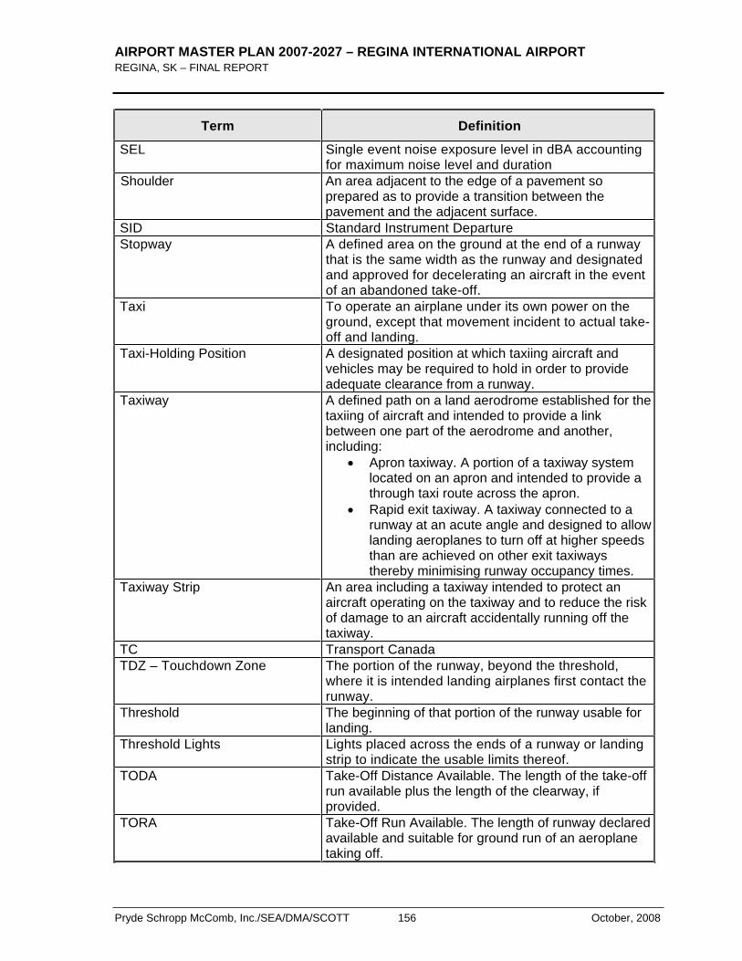
AIRPORT MASTER PLAN 2007-2027 – REGINA INTERNATIONAL AIRPORT REGINA, SK – FINAL REPORT
Pryde Schropp McComb, Inc./SEA/DMA/SCOTT 156 October, 2008
Term Definition
SEL Single event noise exposure level in dBA accounting for maximum noise level and duration
Shoulder An area adjacent to the edge of a pavement so prepared as to provide a transition between the pavement and the adjacent surface.
SID Standard Instrument Departure Stopway A defined area on the ground at the end of a runway
that is the same width as the runway and designated and approved for decelerating an aircraft in the event of an abandoned take-off.
Taxi To operate an airplane under its own power on the ground, except that movement incident to actual take-off and landing.
Taxi-Holding Position A designated position at which taxiing aircraft and vehicles may be required to hold in order to provide adequate clearance from a runway.
Taxiway A defined path on a land aerodrome established for the taxiing of aircraft and intended to provide a link between one part of the aerodrome and another, including:
Apron taxiway. A portion of a taxiway system located on an apron and intended to provide a through taxi route across the apron.
Rapid exit taxiway. A taxiway connected to a runway at an acute angle and designed to allow landing aeroplanes to turn off at higher speeds than are achieved on other exit taxiways thereby minimising runway occupancy times.
Taxiway Strip An area including a taxiway intended to protect an aircraft operating on the taxiway and to reduce the risk of damage to an aircraft accidentally running off the taxiway.
TC Transport Canada TDZ – Touchdown Zone The portion of the runway, beyond the threshold,
where it is intended landing airplanes first contact the runway.
Threshold The beginning of that portion of the runway usable for landing.
Threshold Lights Lights placed across the ends of a runway or landing strip to indicate the usable limits thereof.
TODA Take-Off Distance Available. The length of the take-off run available plus the length of the clearway, if provided.
TORA Take-Off Run Available. The length of runway declared available and suitable for ground run of an aeroplane taking off.
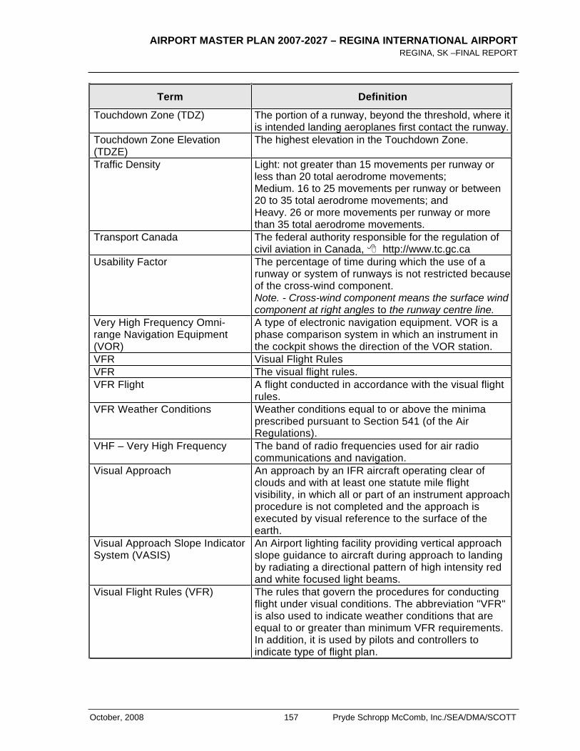
AIRPORT MASTER PLAN 2007-2027 – REGINA INTERNATIONAL AIRPORT REGINA, SK –FINAL REPORT
October, 2008 157 Pryde Schropp McComb, Inc./SEA/DMA/SCOTT
Term Definition
Touchdown Zone (TDZ) The portion of a runway, beyond the threshold, where it is intended landing aeroplanes first contact the runway.
Touchdown Zone Elevation (TDZE)
The highest elevation in the Touchdown Zone.
Traffic Density Light: not greater than 15 movements per runway or less than 20 total aerodrome movements; Medium. 16 to 25 movements per runway or between 20 to 35 total aerodrome movements; and Heavy. 26 or more movements per runway or more than 35 total aerodrome movements.
Transport Canada The federal authority responsible for the regulation of civil aviation in Canada, http://www.tc.gc.ca
Usability Factor The percentage of time during which the use of a runway or system of runways is not restricted because of the cross-wind component. Note. - Cross-wind component means the surface wind component at right angles to the runway centre line.
Very High Frequency Omni-range Navigation Equipment (VOR)
A type of electronic navigation equipment. VOR is a phase comparison system in which an instrument in the cockpit shows the direction of the VOR station.
VFR Visual Flight Rules VFR The visual flight rules. VFR Flight A flight conducted in accordance with the visual flight
rules.VFR Weather Conditions Weather conditions equal to or above the minima
prescribed pursuant to Section 541 (of the Air Regulations).
VHF – Very High Frequency The band of radio frequencies used for air radio communications and navigation.
Visual Approach An approach by an IFR aircraft operating clear of clouds and with at least one statute mile flight visibility, in which all or part of an instrument approach procedure is not completed and the approach is executed by visual reference to the surface of the earth.
Visual Approach Slope Indicator System (VASIS)
An Airport lighting facility providing vertical approach slope guidance to aircraft during approach to landing by radiating a directional pattern of high intensity red and white focused light beams.
Visual Flight Rules (VFR) The rules that govern the procedures for conducting flight under visual conditions. The abbreviation "VFR" is also used to indicate weather conditions that are equal to or greater than minimum VFR requirements. In addition, it is used by pilots and controllers to indicate type of flight plan.
AIRPORT MASTER PLAN 2007-2027 – REGINA INTERNATIONAL AIRPORT REGINA, SK – FINAL REPORT
Pryde Schropp McComb, Inc./SEA/DMA/SCOTT 158 October, 2008
Term Definition
Visual Meteorological Conditions (VMC)
Meteorological conditions expressed in terms of visibility, distance from cloud, and ceiling, equal to or better than specified minima.
VOR – Very High Frequency Omnidirectional Range
A type of radio navigation system using VHF radio frequencies which provides an aircraft pilot with immediate information on the heading to the transmitter.
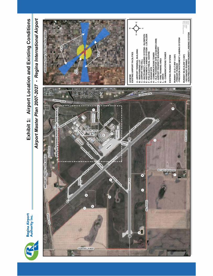
Airp
ortM
aste
rPla
n20
07-2
027
-R
egin
aIn
tern
atio
nalA
irpor
tEx
hibi
t1:
Air
port
Loca
tion
and
Exis
ting
Con
ditio
ns
RU
NW
AY
08-2
6
RUNWAY 13-31
APRON I
TAXIW
AY BRAVO
TAXIW
AY ALPHA
TAXIW
AYCHARLIE
TAXIW
AYPAPA
APR
ON
II
APRON
III
TAXIW
AY
MIKE
Airp
ortM
aste
rPla
nJu
ne20
08PS
MI/
SEA
1095
9
LEGE
NDEX
ISTI
NGAI
RPO
RTFA
CILI
TIES
A-A
IRPO
RTTE
RMIN
ALBU
ILDI
NGB
-MAI
NPA
RKIN
GLO
TC
-AIR
PORT
FIRE
HALL
D-I
NSTR
UMEN
TLA
NDIN
GSY
STEM
-GLI
DEPA
THE
-INS
TRUM
ENT
LAND
ING
SYST
EM-L
OCAL
IZER
F-F
IELD
ELEC
TRIC
ALCE
NTRE
G-R
ADAR
SITE
H-C
OM
MUN
ICAT
IONS
TOW
ERI
-OLD
TRAN
SMIT
ERSI
TE(A
CQU
IRED
2008
)J
-AIR
PORT
PRO
PER
TYBO
UNDA
RYK
-FIR
ETR
AINI
NGAR
EAL
-AW
OS
M-C
OM
MUN
ICAT
IONS
TOW
ER
EXIS
TING
RUNW
AYSY
STEM
RUNW
AY13
-31
(7,9
00'X
150'
)-P
RIM
ARY
RUNW
AY-P
RECI
SION
INST
RUM
ENT
LAND
ING
SYST
EM
RUNW
AY08
-26
(6,2
00'X
150'
)-S
ECO
NDAR
YR
UNW
AY-N
ON-
PREC
ISIO
NIN
STRU
MEN
TLA
NDIN
GSY
STEM
! (A! (B ! (C
! (D
! (E
! (G! (F
TAXIWAYKILO
! (H
ABANDONTA
XIWAY
APRON
IVTA
XIW
AYB
1
LEWVAN DRIVE
LEWVAN DRIVE
13TH
AVEN
UE
25TH
AVE
NU
E
HIL
LA
VEN
UE
COURTNEY STREET
Mc Carthy Bouldevard
REG
INA
AVE
NU
E
14TH
AVE
NU
E
SANDRA SCHMIRLER WAY
TUTOR DRIVE
AIRPORT ROAD
! (I
31
13
26
08
! (J
! (J
! (J
²
AER
ON
AU
TIC
AL
PR
OTE
CTI
ON
AR
EAS
AIR
PO
RT
PRO
TEC
TIO
NA
REA
S
15km
15km
4km
Rad
ius
AIR
PO
RT
TEN
AN
TIN
VEN
TORY
:APP
EN
DIX
A
! (K
! (L! (M
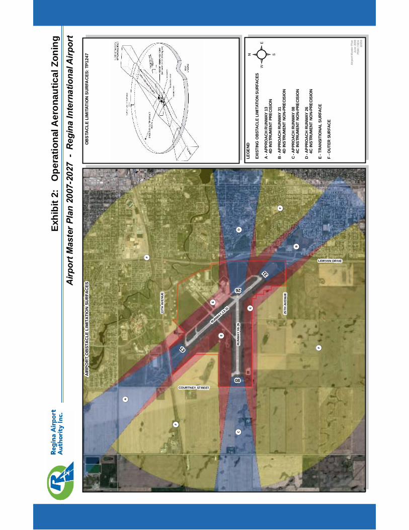
Airp
ortM
aste
rPla
n20
07-2
027
-R
egin
aIn
tern
atio
nalA
irpor
tEx
hibi
t2:
Ope
ratio
nalA
eron
autic
alZo
ning
RU
NW
AY
08-2
6RUNWAY 13-31
Airp
ortM
aste
rPla
nJu
ne20
08PS
MI/
SEA
1095
9
LEGE
ND
EXIS
TING
OBS
TACL
ELI
MIT
ATIO
NSU
RFAC
ES
A-A
PPRO
ACH
RUN
WAY
134D
INST
RUM
ENT
PREC
ISIO
N
B-A
PPRO
ACH
RUNW
AY31
4DIN
STRU
MEN
TNO
N-PR
ECIS
ION
C-A
PPRO
ACH
RUNW
AY08
4CIN
STRU
MEN
TNO
N-PR
ECIS
ION
D-A
PPRO
ACH
RUNW
AY26
4CIN
STRU
MEN
TNO
N-PR
ECIS
ION
E-T
RANS
ITIO
NAL
SURF
ACE
F-O
UTER
SUR
FACE
! (A
LEWVAN DRIVE
25TH
AVE
NU
E
COURTNEY STREET
13TH
AVE
NU
E
31
13
26
08
²
OB
STA
CLE
LIM
ITAT
ION
SU
RFA
CES
:TP1
247
AIR
PO
RT
OB
STA
CLE
LIM
ITAT
ION
SUR
FAC
ES
! (C! (D
! (B
! (E
! (E
! (E
! (F
! (F
! (F
! (F
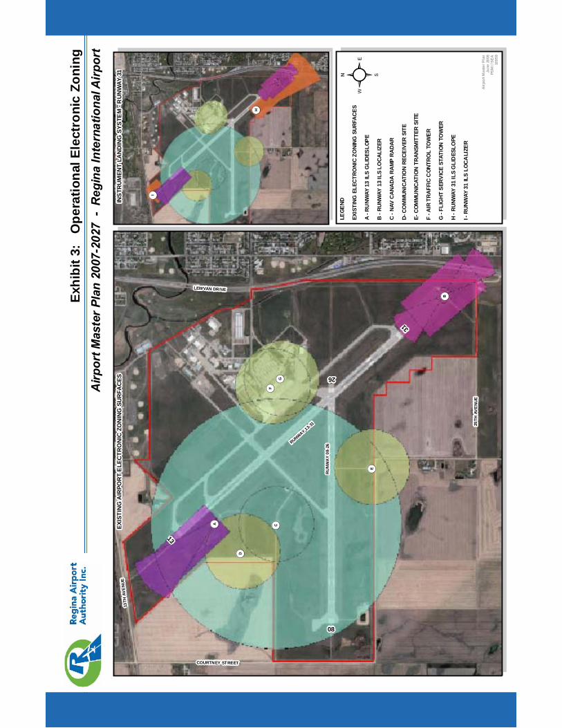
Airp
ortM
aste
rPla
n20
07-2
027
-R
egin
aIn
tern
atio
nalA
irpor
tEx
hibi
t3:
Ope
ratio
nalE
lect
roni
cZo
ning
RU
NW
AY
08-2
6RUNWAY 13-31
Airp
ortM
aste
rPla
nJu
ne20
08PS
MI/
SEA
1095
9
LEGE
ND
EXIS
TING
ELEC
TRO
NIC
ZONI
NGSU
RFAC
ES
A-R
UNW
AY13
ILS
GLI
DESL
OPE
B-R
UNW
AY13
ILS
LOCA
LIZE
R
C-N
AVCA
NADA
RAM
PRA
DAR
D-CO
MM
UNIC
ATIO
NRE
CEIV
ERSI
TE
E-CO
MM
UNI
CATI
ONTR
ANSM
ITTE
RSI
TE
F-A
IRTR
AFFI
CC
ONTR
OL
TOW
ER
G-F
LIG
HTSE
RVIC
EST
ATIO
NTO
WER
H-R
UNW
AY31
ILS
GLI
DES
LOPE
I-RU
NWAY
31IL
SLO
CALI
ZER
! (A
LEWVAN DRIVE
25TH
AVE
NU
E
COURTNEY STREET
13TH
AVE
NU
E
3113
26
08
²
INS
TRU
MEN
TLA
ND
ING
SYS
TEM
-RU
NW
AY31
EXIS
TIN
GA
IRPO
RT
ELE
CTR
ON
ICZO
NIN
GSU
RFA
CES
! (D
! (B
! (G
! (E
! (F
! (C
! (H
! (I
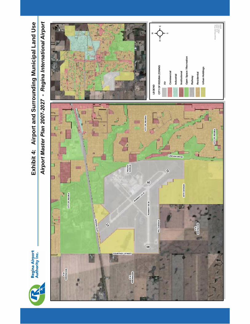
Airp
ortM
aste
rPla
n20
07-2
027
-R
egin
aIn
tern
atio
nalA
irpor
tEx
hibi
t4:
Air
port
and
Surr
ound
ing
Mun
icip
alLa
ndU
se
RU
NW
AY
08-2
6RUNWAY 13-31
Airp
ortM
aste
rPla
nJu
ne20
08PS
MI/
SEA
1095
9
LEGE
ND
CITY
OF
REG
INA
ZONI
NG
Air Co
mm
erci
al
Indu
stria
l
Inst
itutio
nal
Ope
nSp
ace
/Rec
reat
ion
Railw
ay
Resi
dent
ial
Urba
nHo
ldin
gs
LEWVAN DRIVE
25TH
AVE
NU
E
COURTNEY STREET
13TH
AVEN
UE
31
1326
08
²R
.MSH
ER
WO
OD
R.M
SHE
RW
OO
D
R.M
SHE
RW
OO
D
CIT
YO
FR
EG
INA
CIT
YO
FR
EG
INA
CIT
YO
FR
EG
INA
HIL
LA
VEN
UE
REG
INA
AVEN
UE
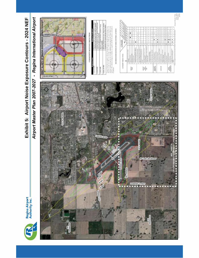
Airp
ortM
aste
rPla
n20
07-2
027
-R
egin
aIn
tern
atio
nalA
irpor
tEx
hibi
t5:
Airp
ortN
oise
Expo
sure
Con
tour
s-2
024
NEF
RU
NW
AY
08-2
6RUNWAY 13-31
²
40-NEF
35-NEF
30-NEF
25-NEF
SEE
INSE
TA:
CITY
OF
REG
INA
SOUT
HW
EST
LAND
SCO
NCEP
T
INSE
TA:
CITY
OF
REG
INA
SOUT
HW
EST
LAND
SCO
NCEP
T
LEWVAN DRIVE
13TH
AVEN
UE
25TH
AVE
NU
E
HIL
LA
VEN
UE
COURTNEY STREET
Mc Carthy Bouldevard
Airp
ortM
aste
rPla
nJu
ne20
08PS
MI/S
EA10
959
RM
SHE
RW
OO
D
RM
SHE
RW
OO
D
CIT
YO
FR
EG
INA
CIT
YO
FR
EG
INA
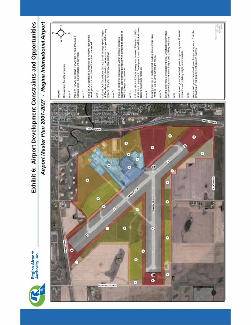
Airp
ortM
aste
rPla
n20
07-2
027
-R
egin
aIn
tern
atio
nalA
irpor
tEx
hibi
t6:
Airp
ortD
evel
opm
entC
onst
rain
tsan
dO
ppor
tuni
ties
RU
NW
AY
08-2
6
RUNWAY 13-31
Airp
ortM
aste
rPla
nJu
ne20
08PS
MI/
SEA
1095
9
! (A
LEWVAN DRIVE
25TH
AVE
NU
E
COURTNEY STREET
13TH
AVE
NU
E
31
13
26
08
! (D
! (B
! (G
! (E
! (F
! (C
! (H
Lege
nd
Dev
elop
men
tAre
aD
escr
iptio
ns
Area
A
Incl
udes
Run
way
13-3
1and
Run
way
08-2
6an
das
soci
ated
runw
ays
strip
s.N
ode
velo
pmen
tper
mitt
ed.
Area
B
Incl
udes
OLS
appr
oach
surfa
cefo
rall
runw
ays.
Non
-airf
ield
deve
lopm
entn
otpe
rmitt
edan
d/or
notr
ecom
men
ded.
Area
C
Incl
udes
OLS
Tran
sitio
nalS
urfa
cefo
rall
runw
ays
upto
ahe
ight
of10
mab
ove
runw
ayel
evat
ion.
Also
prot
ects
forp
aral
lelt
axiw
aysy
stem
.St
ringe
ntde
velo
pmen
tres
trict
ions
.
Area
D
Incl
udes
elec
troni
czo
ning
area
sw
ithin
300m
ofel
ectro
nic
equi
pmen
t.D
evel
opm
entp
erm
itted
with
strin
gent
limita
tions
ofbu
ildin
ghe
ight
and
mat
eria
ls.
Area
E
Incl
udes
elec
troni
c/ra
darz
onin
gar
eabe
twee
n30
0man
d1,
000m
ofel
ectro
nic
equi
pmen
t.D
evel
opm
entp
erm
itted
with
limita
tions
onbu
ildin
ghe
ight
and
mat
eria
ls.
Area
F
Exis
ting
mai
nap
ron
and
term
inal
build
ing
deve
lopm
enta
rea.
Term
inal
rela
ted
deve
lopm
entp
erm
itted
.
Area
G
Exis
ting
com
mer
cial
deve
lopm
enta
rea.
Dev
elop
men
tper
mitt
edw
ithre
stric
tions
onlo
catio
n,he
ight
,and
build
ing
mat
eria
ls.
Area
H
Airs
ide
and
grou
ndsi
dede
velo
pmen
topp
ortu
nity
area
.Pot
entia
lre
stric
tions
onbu
ildin
ghe
ight
,and
mat
eria
ls.
Area
I
Airs
ide
and
grou
ndsi
dede
velo
pmen
topp
ortu
nity
area
.P
oten
tial
limita
tions
onbu
ildin
gsi
ze,l
otsi
zean
dac
cess
.
! (A
! (A
! (B! (B
! (B
! (C! (C
! (C
! (D
! (E
! (E
! (E
! (G
! (H
! (H
! (I
! (I
! (I
! (I
! (I
LEWVAN DRIVE
! (E
²

Airp
ortM
aste
rPla
n20
07-2
027
-R
egin
aIn
tern
atio
nalA
irpor
tEx
hibi
t7:
Airp
ortM
aste
rDev
elop
men
tPla
nLa
yout
RU
NW
AY
08-2
6
RUNWAY 13-31
APRON I
TAXIW
AY BRAVO
TAXIW
AY ALPHA
TAXIW
AYCHARLIE
TAXIW
AYPAPA
APR
ON
II
APRON
III
TAXIW
AY
MIKE
Airp
ortM
aste
rPla
nJu
ne20
08PS
MI/S
EA10
959
LEGE
ND
AIRP
ORT
FACI
LITI
ES
A-A
IRPO
RTTE
RMIN
ALBU
ILDI
NGEX
PANS
ION
B-M
AIN
PARK
ING
LOT
DECK
EXPA
NSIO
NC
-HO
TEL
DEVE
LOPM
ENT
CONC
EPT
D-R
EVIS
EDAP
PRO
ACH
ROAD
SE
-PR
OPO
SED
AIRP
ORT
FIRE
HALL
AND
SERV
ICES
BUIL
DIN
GF
-AIR
TRAF
FIC
CON
TRO
LTO
WER
-OPT
ION
1G
-AIR
TRAF
FIC
CON
TRO
LTO
WER
-OPT
ION
2H
-AIR
TRAF
FIC
CONT
ROL
TOW
ER-O
PTIO
N3
I-M
AIN
APRO
NEX
PANS
ION
J-O
VERN
IGHT
AIRC
RAFT
PARK
ING
K-A
IRCR
AFT
DE-IC
ING
PAD
(2CO
DEC)
L-A
IRCA
RGO
M-A
IRSI
DECO
MM
ERCI
ALN
-GEN
ERAL
AVIA
TION
HANG
ARS
AND
TIE-
DOW
NO
-GRO
UNDS
IDE
COM
MER
CIAL
P-O
LDTR
ANSM
ITER
SITE
Q-T
AXIW
AYSY
STEM
ENHA
NCEM
ENTS
R-A
PRO
NI/I
IINF
ILLS
RUNW
AYSY
STEM
RUNW
AY13
-31
(9,0
00'X
150'
)-P
RIM
ARY
RUNW
AY-I
NSTR
UMEN
TLA
NDIN
GSY
STEM
-EXT
ENDE
D1,
100'
RUNW
AY08
-26
(6,2
00'X
150'
)-S
ECO
NDAR
YR
UNW
AY
! (A
! (B
! (C
TAXIWAYKILO! (H
! (F
! (E
! (D
RETTAXIWAY
! (G
RET
TAXI
WAY
TAXIW
AY ECHO
TAXIW
AY EXTENSION
RUNWAY EXTENSION
! (D
! (D
! (I
! (I
! (J
! (K
! (L
! (M! (M
! (N
! (O
LEWVAN DRIVE
LEWVAN DRIVE
13TH
AVEN
UE
25TH
AVE
NU
E
HIL
LA
VEN
UE
COURTNEY STREET
REG
INA
AVE
NU
E
Mc Carthy Bouldevard
3113
26
08
! (P
²
FUTU
RE
AIR
PO
RT
ELEC
TRO
NIC
ZON
ING
PRO
TEC
TIO
NPR
OPO
SED
AIR
POR
TD
EVE
LOP
ME
NTS
! (O
TAX
IWAY
BR
AVO
1
PROPERTY LINE CHANGE
! (R
! (R
! (Q
! (Q
! (Q
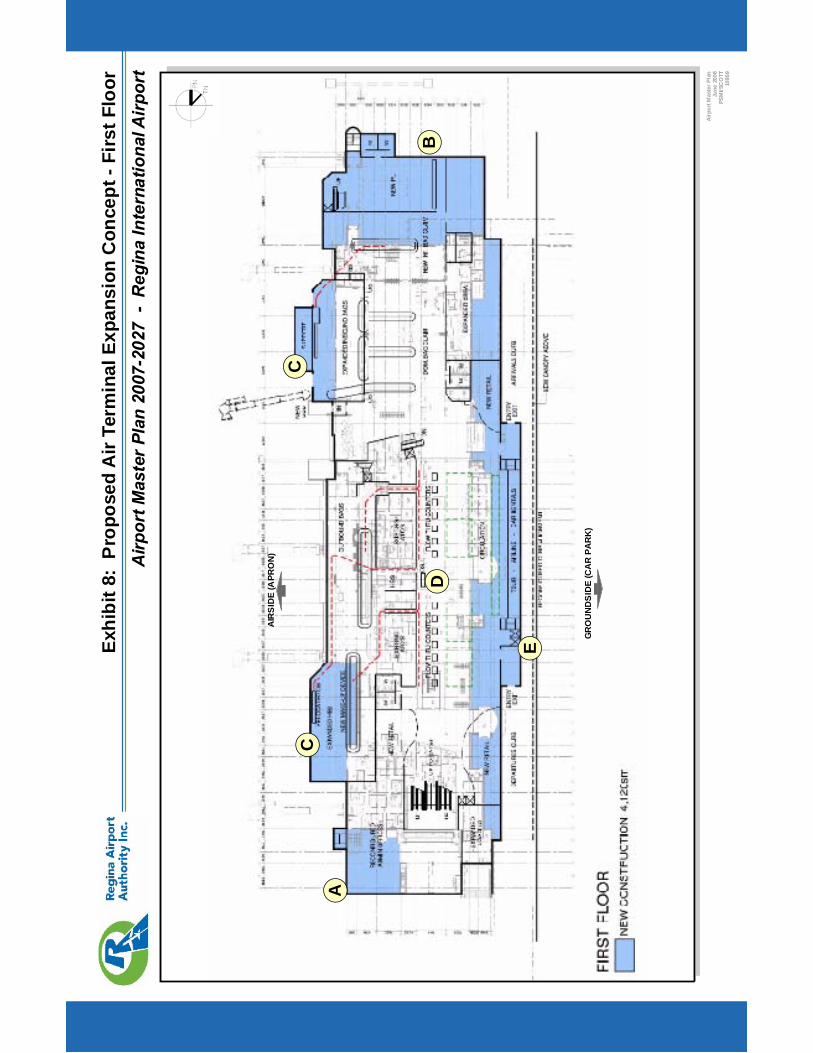
Airp
ortM
aste
rPla
n20
07-2
027
-R
egin
aIn
tern
atio
nalA
irpor
tEx
hibi
t8:
Pro
pose
dA
irTe
rmin
alEx
pans
ion
Con
cept
-Firs
tFlo
or
Airp
ortM
aste
rPla
nJu
ne20
08PS
MI/S
CO
TT10
959
! (A
! (B
! (C
! (D
! (C
! (E
GR
OU
ND
SID
E(C
AR
PAR
K)
AIR
SID
E(A
PRO
N)
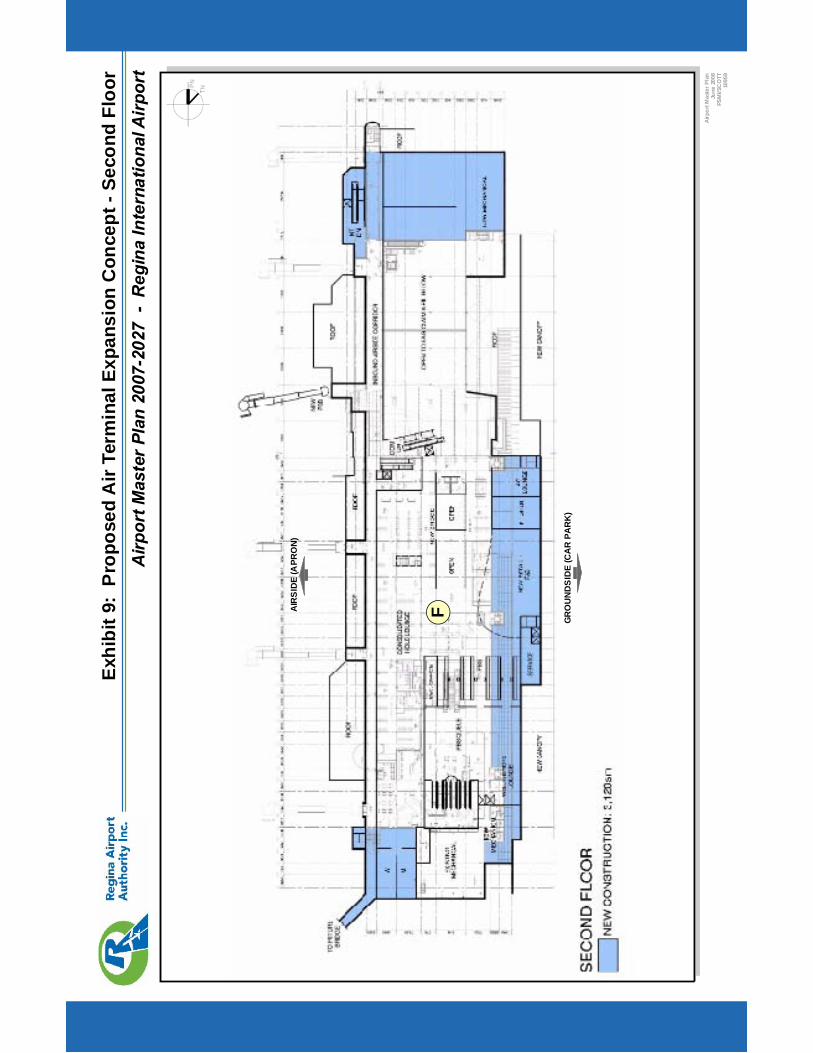
Airp
ortM
aste
rPla
n20
07-2
027
-R
egin
aIn
tern
atio
nalA
irpor
tEx
hibi
t9:
Pro
pose
dA
irTe
rmin
alEx
pans
ion
Con
cept
-Sec
ond
Floo
r
Airp
ortM
aste
rPla
nJu
ne20
08PS
MI/S
CO
TT10
959
GR
OU
ND
SID
E(C
AR
PAR
K)
AIR
SID
E(A
PRO
N)
! (F
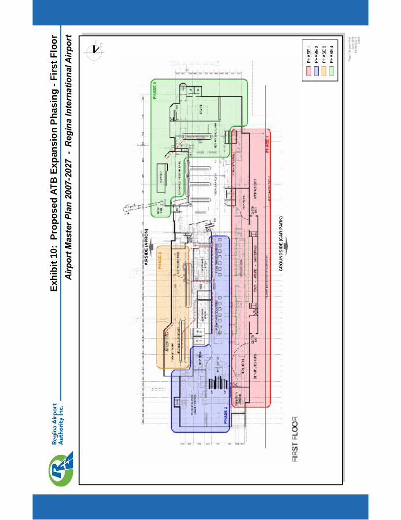
Airp
ortM
aste
rPla
n20
07-2
027
-R
egin
aIn
tern
atio
nalA
irpor
tEx
hibi
t10:
Prop
osed
ATB
Expa
nsio
nP
hasi
ng-F
irstF
loor
Airp
ortM
aste
rPla
nJu
ne20
08PS
MI/S
CO
TT10
959
GR
OU
ND
SID
E(C
AR
PAR
K)
AIR
SID
E(A
PRO
N)
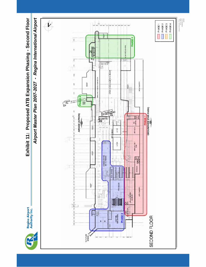
Airp
ortM
aste
rPla
n20
07-2
027
-R
egin
aIn
tern
atio
nalA
irpor
tEx
hibi
t11:
Prop
osed
ATB
Exp
ansi
onPh
asin
g-S
econ
dFl
oor
Airp
ortM
aste
rPla
nJu
ne20
08PS
MI/S
CO
TT10
959
GR
OU
ND
SID
E(C
AR
PAR
K)
AIR
SID
E(A
PRO
N)

Airp
ortM
aste
rPla
n20
07-2
027
-R
egin
aIn
tern
atio
nalA
irpor
tEx
hibi
t12:
Prop
osed
Gro
unds
ide
Com
mer
cial
Dev
elop
men
tCon
cept
s
Airp
ortM
aste
rPla
nJu
ne20
08PS
MI/S
EA10
959
A:G
roun
dsid
eD
evel
opm
entI
nfill
(Exi
stin
gDe
velo
pmen
tAre
as)
D:So
uth
Gro
unds
ide
Com
mer
cial
Spac
e(U
ndev
elop
ed)
B:G
roun
dsid
eEx
pans
ion
Nort
hern
Airp
ortL
and
(Buf
ferA
irsid
eC
omm
eric
al)
C:Te
rmin
alB
uild
ing
/Airp
ortH
otel
Con
cept
E:R
aise
dLe
velP
arki
ngC
ompl
ete
E:R
aise
dLe
velP
arki
ngIn
itial
Phas
e
Prop
osed
Airp
ortM
aste
rPla
nLa
yout
RU
NW
AY
08-2
6
! (A
RUNWAY 13-31
13th
AVEN
UELEWVAN DRIVE
HIL
LA
VEN
UE
! (B ! (C
! (D! (E
CO
MM
ER
CIA
LD
EVEL
OP
ME
NT
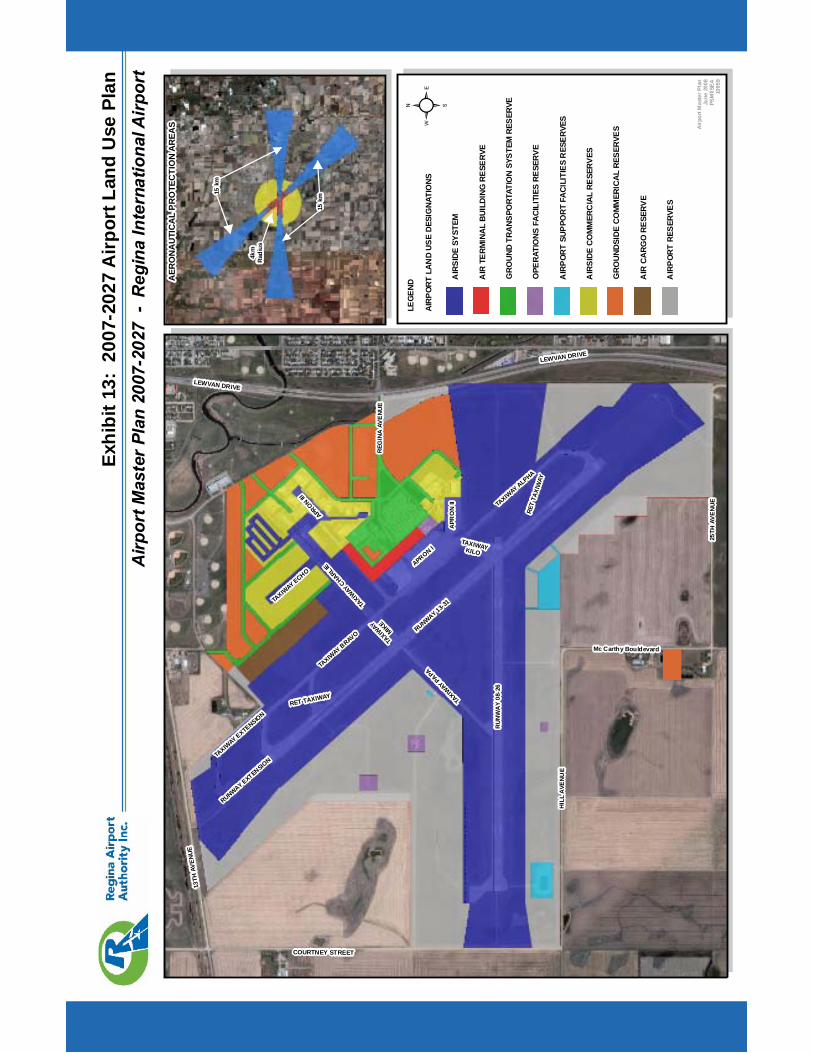
Airp
ortM
aste
rPla
n20
07-2
027
-R
egin
aIn
tern
atio
nalA
irpor
tEx
hibi
t13:
2007
-202
7A
irpor
tLan
dU
sePl
an
RU
NW
AY
08-2
6
RUNWAY 13-31
APRON I
TAXIW
AY BRAVO
TAXIW
AY ALPHA
TAXIW
AYCHARLIE
TAXIW
AYPAPA
APR
ON
II
APRON
III
TAXIW
AY
MIKE
Airp
ortM
aste
rPla
nJu
ne20
08PS
MI/S
EA10
959
²LE
GEND
AIRP
ORT
LAN
DUS
EDE
SIG
NATI
ONS
AIR
SIDE
SYST
EM
AIR
TERM
INAL
BUIL
DING
RESE
RVE
GRO
UND
TRAN
SPO
RTAT
ION
SYST
EMRE
SERV
E
OPE
RATI
ONS
FACI
LITI
ESRE
SERV
E
AIR
PORT
SUPP
ORT
FACI
LITI
ESR
ESER
VES
AIR
SIDE
COM
MER
CIA
LRE
SERV
ES
GRO
UNDS
IDE
COM
MER
ICAL
RESE
RVES
AIR
CARG
ORE
SERV
E
AIR
PORT
RESE
RVES
TAXIWAYKILO
RET TAXIWAY
RET
TAXI
WAY
TAXIW
AY ECHO
TAXIW
AY EXTENSION
RUNWAY EXTENSION
LEWVAN DRIVE
LEWVAN DRIVE
13TH
AVEN
UE
25TH
AVE
NU
E
HIL
LA
VEN
UE
COURTNEY STREET
Mc Carthy Bouldevard
REG
INA
AVE
NU
E
AER
ON
AU
TIC
AL
PR
OTE
CTI
ON
AR
EAS
15km
15km
4km
Rad
ius
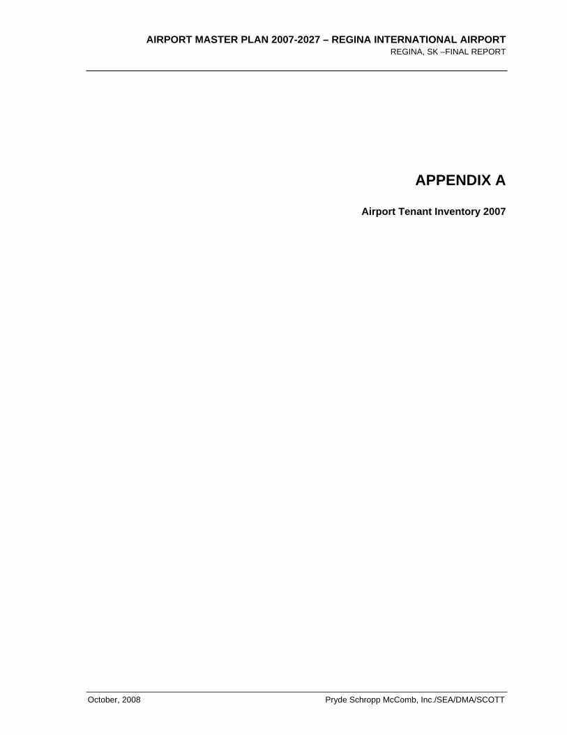
AIRPORT MASTER PLAN 2007-2027 – REGINA INTERNATIONAL AIRPORT REGINA, SK –FINAL REPORT
October, 2008 Pryde Schropp McComb, Inc./SEA/DMA/SCOTT
APPENDIX A
Airport Tenant Inventory 2007

AIRPORT MASTER PLAN 2007-2027 – REGINA INTERNATIONAL AIRPORT REGINA, SK – FINAL REPORT
Pryde Schropp McComb, Inc./SEA/DMA/SCOTT October, 2008
AIR
POR
T M
AST
ER P
LAN
200
7-20
27 –
REG
INA
INTE
RN
ATI
ON
AL
AIR
POR
T R
EG
INA
, SK
–FI
NA
L R
EP
OR
T
Oct
ober
, 200
8
Pry
de S
chro
pp M
cCom
b, In
c./S
EA
/DM
A/S
CO
TT
APP
END
IX B
Exis
ting
Airp
ort T
echn
ical
Dat
a (2
007)

AIR
POR
T M
AST
ER P
LAN
200
7-20
27 –
REG
INA
INTE
RN
ATI
ON
AL
AIR
POR
T R
EG
INA
, SK
– F
INA
L R
EP
OR
T
Pry
de S
chro
pp M
cCom
b, In
c./S
EA
/DM
A/S
CO
TT
O
ctob
er, 2
008
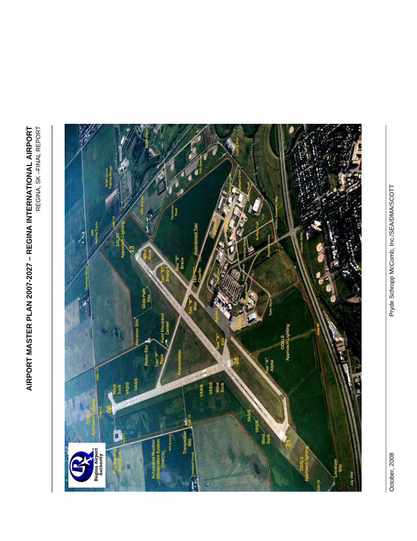
AIR
POR
T M
AST
ER P
LAN
200
7-20
27 –
REG
INA
INTE
RN
ATI
ON
AL
AIR
POR
T R
EG
INA
, SK
–FI
NA
L R
EP
OR
T
Oct
ober
, 200
8
Pry
de S
chro
pp M
cCom
b, In
c./S
EA
/DM
A/S
CO
TT
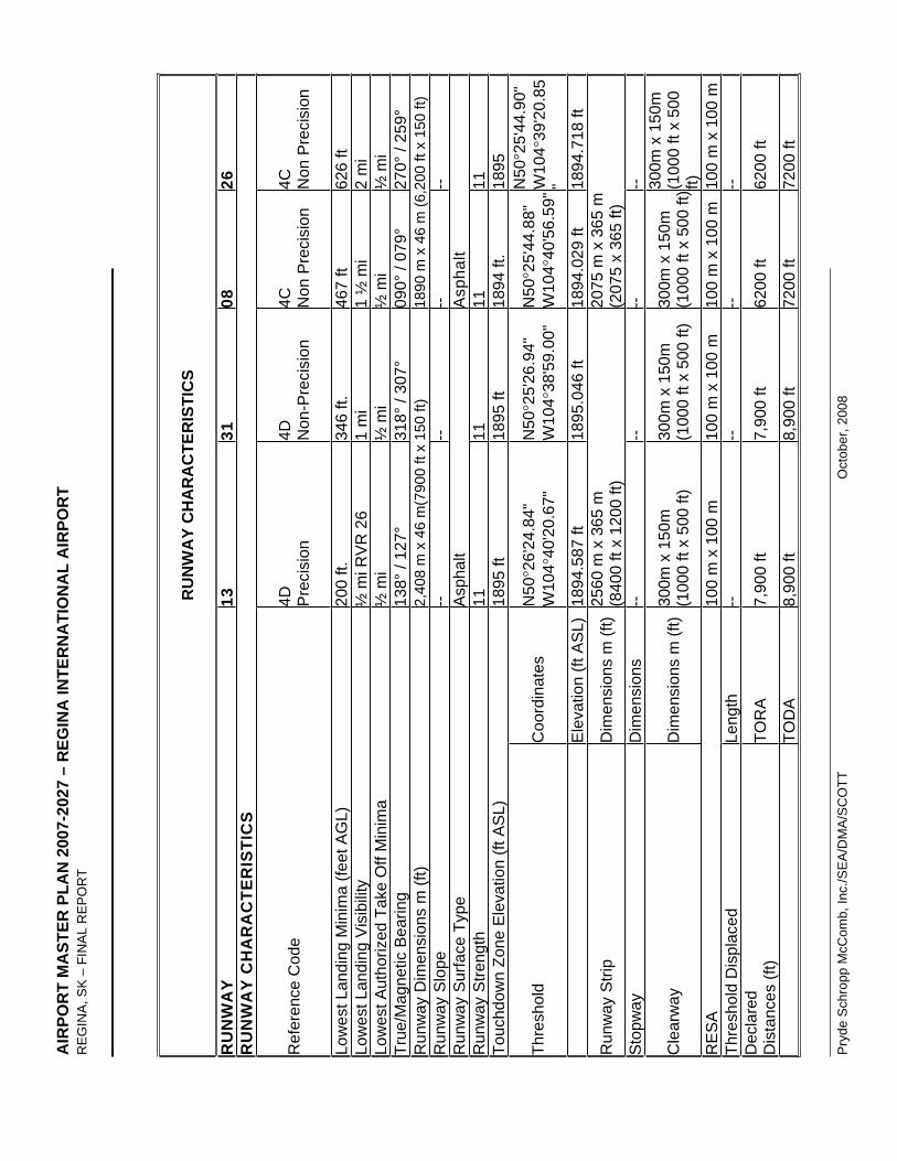
AIR
POR
T M
AST
ER P
LAN
200
7-20
27 –
REG
INA
INTE
RN
ATI
ON
AL
AIR
POR
T R
EG
INA
, SK
– F
INA
L R
EP
OR
T
Pry
de S
chro
pp M
cCom
b, In
c./S
EA
/DM
A/S
CO
TT
O
ctob
er, 2
008
RU
NW
AY
CH
AR
AC
TER
ISTI
CS
RU
NW
AY
1331
0826
RU
NW
AY
CH
AR
AC
TER
ISTI
CS
Ref
eren
ce C
ode
4D Pre
cisi
on4D N
on-P
reci
sion
4C Non
Pre
cisi
on
4C Non
Pre
cisi
on
Low
est L
andi
ng M
inim
a (fe
et A
GL)
20
0 ft.
34
6 ft.
46
7 ft
626
ft Lo
wes
t Lan
ding
Vis
ibili
ty
½ m
i RV
R 2
6 1
mi
1 ½
mi
2 m
i Lo
wes
t Aut
horiz
ed T
ake
Off
Min
ima
½ m
i ½
mi
½ m
i ½
mi
True
/Mag
netic
Bea
ring
138°
/ 12
7°
318°
/ 30
7°
090°
/ 07
9°
270°
/ 25
9°
Run
way
Dim
ensi
ons
m (f
t) 2,
408
m x
46
m(7
900
ft x
150
ft)
1890
m x
46
m (6
,200
ft x
150
ft)
Run
way
Slo
pe
--
--
--
--
Run
way
Sur
face
Typ
e A
spha
lt A
spha
lt R
unw
ay S
treng
th
11
11
11
11
Touc
hdow
n Zo
ne E
leva
tion
(ft A
SL)
18
95 ft
18
95 ft
18
94 ft
. 18
95
Thre
shol
d C
oord
inat
es
N50
26'2
4.84
"W
104
40'2
0.67
"N
5025
'26.
94"
W10
438
'59.
00"
N50
25'4
4.88
"W
104
40'5
6.59
"N50
25'4
4.90
"W
104
39'2
0.85
"
Ele
vatio
n (ft
AS
L)
1894
.587
ft
1895
.046
ft
1894
.029
ft
1894
.718
ft
Run
way
Stri
p D
imen
sion
s m
(ft)
2560
m x
365
m
(840
0 ft
x 12
00 ft
) 20
75 m
x 3
65 m
(2
075
x 36
5 ft)
S
topw
ay
Dim
ensi
ons
--
--
--
--
Cle
arw
ay
Dim
ensi
ons
m (f
t)30
0m x
150
m
(100
0 ft
x 50
0 ft)
30
0m x
150
m
(100
0 ft
x 50
0 ft)
30
0m x
150
m
(100
0 ft
x 50
0 ft)
300m
x 1
50m
(1
000
ft x
500
ft)R
ES
A
100
m x
100
m
100
m x
100
m
100
m x
100
m
100
m x
100
mTh
resh
old
Dis
plac
ed
Leng
th
--
--
--
--
Dec
lare
dD
ista
nces
(ft)
TOR
A
7,90
0 ft
7,90
0 ft
6200
ft
6200
ft
TO
DA
8,
900
ft 8,
900
ft 72
00 ft
72
00 ft
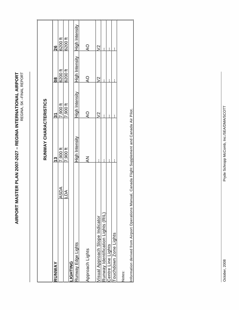
AIR
POR
T M
AST
ER P
LAN
200
7-20
27 –
REG
INA
INTE
RN
ATI
ON
AL
AIR
POR
T R
EG
INA
, SK
–FI
NA
L R
EP
OR
T
Oct
ober
, 200
8
Pry
de S
chro
pp M
cCom
b, In
c./S
EA
/DM
A/S
CO
TT
RU
NW
AY
CH
AR
AC
TER
ISTI
CS
RU
NW
AY
1331
0826
A
SD
A
7,90
0 ft
7,90
0 ft
6200
ft
6200
ft
LD
A
7,90
0 ft
7,90
0 ft
6200
ft
6200
ft
LIG
HTI
NG
Run
way
Edg
e Li
ghts
H
igh
Inte
nsity
H
igh
Inte
nsity
H
igh
Inte
nsity
H
igh
Inte
nsity
App
roac
h Li
ghts
A
N
AO
A
O
AO
Vis
ual A
ppro
ach
Slo
pe In
dica
tor
--
V2
V2
V2
Run
way
Iden
tific
atio
n Li
ghts
(R
IL)
--
--
--
--
Cen
tre
Line
Lig
hts
--
--
--
--
Touc
hdow
n Zo
ne L
ight
s --
--
--
--
Not
es:
Info
rmat
ion
deriv
ed fr
om A
irpor
t Ope
ratio
ns M
anua
l, C
anad
a Fl
ight
Sup
plem
ent a
nd C
anad
a A
ir P
ilot.
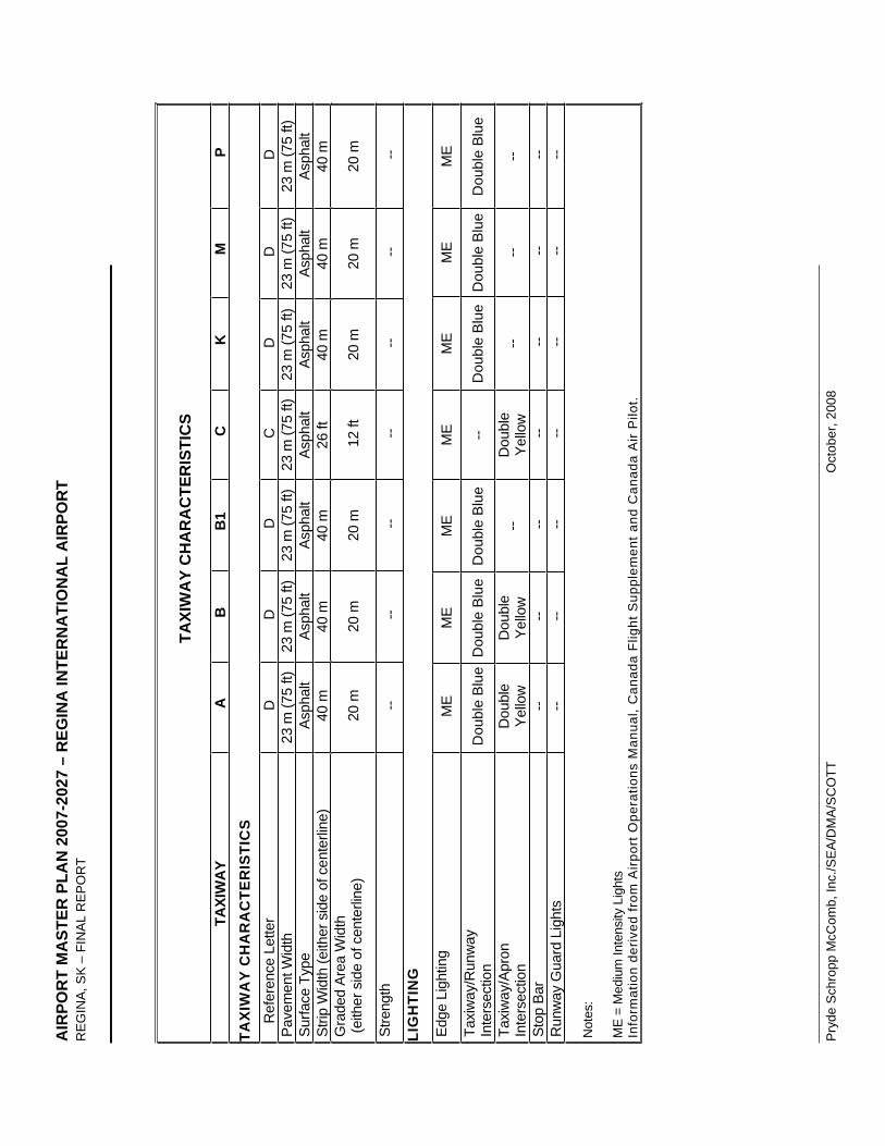
AIR
POR
T M
AST
ER P
LAN
200
7-20
27 –
REG
INA
INTE
RN
ATI
ON
AL
AIR
POR
T R
EG
INA
, SK
– F
INA
L R
EP
OR
T
Pry
de S
chro
pp M
cCom
b, In
c./S
EA
/DM
A/S
CO
TT
O
ctob
er, 2
008
TAXI
WA
Y C
HA
RA
CTE
RIS
TIC
S
TAXI
WA
YA
BB
1C
KM
PTA
XIW
AY
CH
AR
AC
TER
ISTI
CS
R
efer
ence
Let
ter
D
D
D
C
D
D
D
Pave
men
t Wid
th
23 m
(75
ft)
23 m
(75
ft)
23 m
(75
ft)
23 m
(75
ft)
23 m
(75
ft)
23 m
(75
ft)
23 m
(75
ft)
Surfa
ce T
ype
Asph
alt
Asph
alt
Asph
alt
Asph
alt
Asph
alt
Asph
alt
Asph
alt
Strip
Wid
th (e
ither
sid
e of
cen
terli
ne)
40 m
40
m
40 m
26
ft
40 m
40
m
40 m
G
rade
d Ar
ea W
idth
(e
ither
sid
e of
cen
terli
ne)
20 m
20
m
20 m
12
ft
20 m
20
m
20 m
Stre
ngth
--
-- --
-- --
-- --
LIG
HTI
NG
Edge
Lig
htin
g M
E M
E M
E M
E M
E M
E M
E Ta
xiw
ay/R
unw
ay
Inte
rsec
tion
Dou
ble
Blu
eD
oubl
e B
lue
Dou
ble
Blu
e--
D
oubl
e B
lue
Dou
ble
Blu
eD
oubl
e B
lue
Taxi
way
/Apr
on
Inte
rsec
tion
Dou
ble
Yello
wD
oubl
eYe
llow
--D
oubl
eYe
llow
-- --
--
Stop
Bar
--
-- --
-- --
-- --
Run
way
Gua
rd L
ight
s --
-- --
-- --
-- --
Not
es:
ME
= M
ediu
m In
tens
ity L
ight
s In
form
atio
n de
rived
from
Airp
ort O
pera
tions
Man
ual,
Can
ada
Flig
ht S
uppl
emen
t and
Can
ada
Air
Pilo
t.
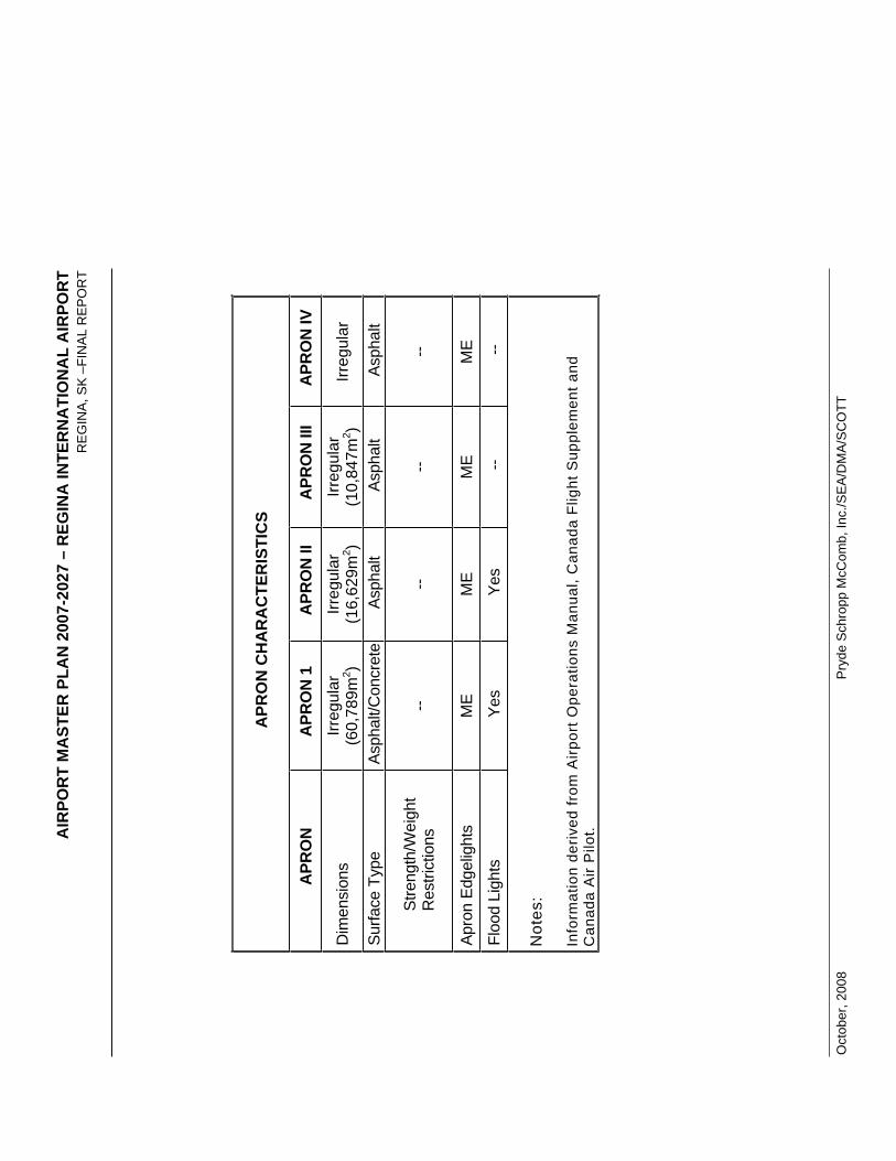
AIR
POR
T M
AST
ER P
LAN
200
7-20
27 –
REG
INA
INTE
RN
ATI
ON
AL
AIR
POR
T R
EG
INA
, SK
–FI
NA
L R
EP
OR
T
Oct
ober
, 200
8
Pry
de S
chro
pp M
cCom
b, In
c./S
EA
/DM
A/S
CO
TT
APR
ON
CH
AR
AC
TER
ISTI
CS
APR
ON
A
PRO
N 1
A
PRO
N II
A
PRO
N II
I A
PRO
N IV
Dim
ensi
ons
Irreg
ular
(60,
789m
2 )Irr
egul
ar(1
6,62
9m2 )
Irreg
ular
(10,
847m
2 )Irr
egul
ar
Surfa
ce T
ype
Asph
alt/C
oncr
ete
Asph
alt
Asph
alt
Asph
alt
Stre
ngth
/Wei
ght
Res
trict
ions
--
-- --
--
Apro
n Ed
gelig
hts
ME
ME
ME
ME
Floo
d Li
ghts
Ye
s Ye
s --
--
Not
es:
Info
rmat
ion
deriv
ed fr
om A
irpor
t Ope
ratio
ns M
anua
l, C
anad
a Fl
ight
Sup
plem
ent a
nd
Can
ada
Air
Pilo
t.
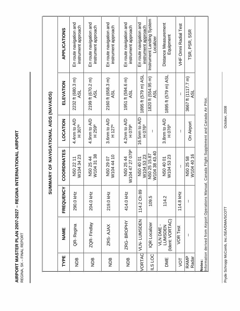
AIR
POR
T M
AST
ER P
LAN
200
7-20
27 –
REG
INA
INTE
RN
ATI
ON
AL
AIR
POR
T R
EG
INA
, SK
– F
INA
L R
EP
OR
T
Pry
de S
chro
pp M
cCom
b, In
c./S
EA
/DM
A/S
CO
TT
O
ctob
er, 2
008
SU
MM
AR
Y O
F N
AV
IGA
TIO
NA
L A
IDS
(NA
VA
IDS
)
TYPE
N
AM
E FR
EQU
ENC
YC
OO
RD
INA
TES
LOC
ATI
ON
EL
EVA
TIO
N
APP
LIC
ATI
ON
S
ND
BQ
R- R
egin
a 29
0.0
kHz
N50
22
11W
104
34 2
3 4.
4nm
to A
/D
H 3
07º
2232
ft (6
80.3
m)
AS
LEn
rout
e na
viga
tion
and
inst
rum
ent a
ppro
ach
ND
BZQ
R- F
indl
ay
204.
0 kH
z N
50 2
5 44
W10
4 31
38
4.9n
m to
A/D
H
259
º 21
99 ft
(670
.2 m
) A
SL
En ro
ute
navi
gatio
n an
d in
stru
men
t app
roac
h
ND
BZR
S- A
JAX
219.
0 kH
z N
50 2
9 07
W10
4 44
10
3.6n
m to
A/D
H
127
º 21
60 ft
(658
.3 m
) A
SL
En ro
ute
navi
gatio
n an
d in
stru
men
t app
roac
h
ND
BZR
G- B
RO
PHY
414.
0 kH
z N
50 2
5 44
W10
4 47
27
079º
4.2n
m to
A/D
H
079
º 19
51 ft
(594
.6 m
) A
SL
En ro
ute
navi
gatio
n an
d in
stru
men
t app
roac
h
VO
RTA
C V
LN- L
UM
SDEN
11
4.2
Ch
89
N50
40
01W
104
53 2
3 16
.5nm
to A
/DH
076
º 18
95 ft
(579
m) A
SL
En ro
ute
navi
gatio
n an
d in
stru
men
t app
roac
h
ILS
LO
C
IQR
Loc
aliz
er
109.
5 N
50 2
5 15
.87
W10
4 38
43.
40
--18
20 ft
(554
.95
m)
AS
LIn
stru
men
t Lan
ding
Sys
tem
Lo
caliz
er
DM
EVL
N D
ME
- LU
MSD
EN(Id
ent:
VOR
TAC
) 11
4.2
N50
40
01W
104
53 2
3 3.
8nm
to A
/D
H 0
76º
1895
ft (5
79 m
) AS
LD
ista
nce
Mea
sure
men
t Eq
uipm
ent
VO
TVO
R T
est
114.
8 kH
z --
--
-- VH
F O
mni
Rad
ial T
est
RA
MP
Rad
ar--
-- N
50 2
5 58
W10
4 40
16
On
Airp
ort
3667
ft (1
117.
7 m
) A
SL
TSR
, PSR
, SSR
Not
es:
Info
rmat
ion
deriv
ed fr
om A
irpor
t Ope
ratio
ns M
anua
l, C
anad
a Fl
ight
Sup
plem
ent a
nd C
anad
a A
ir P
ilot.

AIRPORT MASTER PLAN 2007-2027 – REGINA INTERNATIONAL AIRPORT REGINA, SK –FINAL REPORT
October, 2008 Pryde Schropp McComb, Inc./SEA/DMA/SCOTT
APPENDIX C
Air Terminal Building Technical Analysis 2027

AIRPORT MASTER PLAN 2007-2027 – REGINA INTERNATIONAL AIRPORT REGINA, SK – FINAL REPORT
Pryde Schropp McComb, Inc./SEA/DMA/SCOTT October, 2008
FEBRUARY 29, 2008
Terminal Review and Master Plan Report
REGINA INTERNATIONAL AIRPORTREGINA, SASKATCHEWAN
prepared byS C O T T A s s o c i a t e s A r c h i t e c t s I n c 80 Bloor Street West Suite 1400 Toronto ON Canada M5S 2V1
Ph +416-975-5200 Fx +416-975-4990 [email protected] www.saai.ca
Regina International Airport : TERMINAL REVIEW and MASTER PLAN REPORT Page 2 of 19
SCOTT Associates Architects Inc. February 29, 2008
EXISTING TERMINAL REVIEW
1.0 INTRODUCTION
An on-site review of the existing Passenger Terminal Building (PTB) was conducted on January 15, 2008. A number of physical constraints on operational and functional areas were identified during this site visit and during subsequent examination of relevant documentation and building plans.
This report contains: an identification of the primary constraints on passenger processing and baggage handling, a brief analysis of the maximum theoretical throughput capacities of various choke points, and a series of suggestion on how the noted problems could be alleviated.
Calculations of throughput capacities were based on the International Air Transport Association's (IATA’s) Level of Service (LOS) standards. It should be noted that the LOS category adopted by Transport Canada for the purpose of planning Canadian airports, is category C.
Category C, or LOS-C, is defined in IATA's Airport Development Reference Manual (ADRM), 9th
addition 2004 as, "Good level of service; Conditions of stable flow, acceptable delays and good level of comfort".
2.0 CHECK-IN
The check-in counter arrangement at Regina Airport PTB is linear with primarily dedicated airline positions (non CUTE/CUSS). The arrangement is split between the two principal carriers, WestJet in the south quadrant and Air Canada Jazz in the north quadrant.
2.1 CUTE
The decision by an airport to utilize Common Use Terminal Equipment (CUTE) is an operational one. The use of CUTE at check-in permits any airline to utilize any check-in counter. It is generally accepted in the industry that for air terminals processing under 5 million passengers per annum, adoption of CUTE check-in positions will result in an efficiency increase of 5% to 8% in the peak hour processing capacity over the capacity achievable under a dedicated counter check-in configuration.
2.2 CUSS
Common Use Self-Service (CUSS) is a facility that provides self-service applications (at check-in) to passengers on a shared kiosk. This allows airlines to share self-service kiosks without installing and running proprietary hardware.
CUSS reduces the need for airports to provide space for individual airline kiosks in common use areas. Since the kiosks can be located anywhere, the check-in process, to a degree, can be decentralized.
Regina International Airport : TERMINAL REVIEW and MASTER PLAN REPORT Page 3 of 19
SCOTT Associates Architects Inc. February 29, 2008
A study would have to be conducted by the Regina Airport in consultation with the airlines in order to determine if a CUSS system is warranted at an airport where the majority of scheduled flights are operated by only two airlines.
2.3 Constraints
The primary constraint in the Departures Hall relates to queue depth at the opposing check-in and car rental counters. The existing overall depth is approximately 12.5 meters, comprised of: 6 meters for queuing and processing at check-in, 3.5 meters for cross circulation and 3 meters for queuing and processing at the car rental counters.
In addition to the dimensionally constrained Check-in Hall, there is an elevator core at grid line 12/13 that further reduces effective Check-in Hall depth to only 9 meters.The recommended optimum depth for this type of configuration is 20 to 24 meters, translating to a recommended increase in the Departures Hall depth of 9 meters.This recommendation is based on defined programming data for the analysis of Departure Concourse and Check-in Hall.
For the Check-in Hall, the area per passenger, based on LOS-C, should be 1.3m² (assuming few carts and 1 or 2 pieces of luggage per passenger). The corresponding queue width should be 1.2 meters. Where flights dictate a high percentage of carts, queue widths should be 1.4 meters and the area per passenger should be increased to 1.7m² (i.e. charter "sun" flights).
The calculation of required queue depth is based on the number of counters allocated per flight and the percentage of passengers utilizing kiosks, self check-in and baggage drop. For example, the standard for a B747 is 8 counters, while the number of counters allocated to a narrow body single class aircraft may be only 3.
The IATA recommended queue and processing depth at LOS-C, measured from the face of the counter, is as follows:
2.5 meters for processing and circulation, 8.5 meters for queuing and, 4.0 meters for a one-way circulation concourse and check-in queue backflow or 5.0 meters for a circulation concourse supporting significant cross flow.
In the case of Regina, where additional counters supporting tour companies, rental agencies, etc. face onto the concourse, additional circulation and queuing have to be provided for these operations.
For tour desks and rental car counters (where significant numbers of baggage carts are not anticipated), a processing and circulation depth of 2 meters is considered satisfactory. The queue depth should of course be based on programmed loads, however if a bank queue is envisaged, a depth of 3 to 5 meters is generally acceptable.
Regina International Airport : TERMINAL REVIEW and MASTER PLAN REPORT Page 4 of 19
SCOTT Associates Architects Inc. February 29, 2008
Special Note: The calculation of queuing depth is determined by a formula utilizing data related to the number of passengers checking-in in a 15 minute period, the number of allocated counters, the area per passenger plus required queue width.
2.4 Additional Constraints
The existing elevator core at grid line 12/13 reduces check-in depth to an unacceptable 9 meters. This elevator should be relocated to the exterior face of the terminal. This change could be put into effect without undue impact on functionality, and would improve cross terminal circulation.
2.5 Departures Processing
There are approximately 22 full-service check-in positions at Regina Airport. At an assumed average processing rate of 20 passengers/counter/hour (using CUTE), the effective processing capacity is 440 passengers/peak hour (if all counters are staffed). If 15% of passengers utilize kiosks, the effective overall existing check-in throughput is 520 passengers/peak hour.
The existing linear check-in counters are generous in width measuring approximately 1.2 meters for a single unit and 2.4 meters for a double unit. An increase in the number of counters could be achieved under a counter replacement program whereby the existing counters are replaced by standard double units with a width dimension of 1.8 meters and a pass through width of 1.0 to 1.1 meters.
It should be noted that the Airport Authority, in conjunction with Westjet, has already developed a schematic flow-through counter layout that would potentially alleviate passenger cross flow congestion in the Check-in Hall.
However, this option necessitates relocating a significant area of existing ATO space currently located directly behind the check-in counters. In addition, the existing HBS operation for oversize bags (which is centrally located between the two counter banks), has limited potential for modification without a significant rebuild of the HBS operation.
As a consequence, this reconfiguration is not recommended if future realignment of the curb frontage as shown on the accompanying Master Plan is implemented.
3.0 CONCESSIONS AND PRE-BOARD SCREENING
Passengers currently flow directly from check-in to an escalator/stair component located at gridline 5/8. This escalator/stair leads directly to the upper level Pre-board Screening queue. There are no effective concessions at the ground level on this routing.
Regina International Airport : TERMINAL REVIEW and MASTER PLAN REPORT Page 5 of 19
SCOTT Associates Architects Inc. February 29, 2008
3.1 Observations
A potential exists for the relocation of the Airport Operations offices into a new expansion structure. This would facilitate repositioning of the vertical transportation node to the southeast and development of additional concessions clustered along the departures route.
3.2 Upper Level Concessions
The majority of landside concessions utilized by departing passengers are located on the second level and while these concessions have good exposure to passengers ascending the up escalator en route to Pre-board Screening (PBS), it has been observed that these concessions, including Duty Free and the only major food outlet, are by-passed by passengers anxious to process through PBS during peak hours of operation. If these concessions were to be redistributed to the ground level, increased utilization could be expected.
Refer to terminal reconfiguration Master Plan attached.
4.0 PRE-BOARD SCREENING (PBS)
The PBS facility currently supports 3 x-ray lanes. While no on-site measurements were undertaken regarding processing rates, CATSA has reported a throughput rate of 105 to 115 passengers/lane/hour. This translates to a processing rate of 315 to 345 passengers/peak hour for this facility.
The restricted processing capacity of this facility at peak hour is demonstrated by signage at the queuing area identifying unacceptable wait times.
Note: IATA recommended LOS-C wait times for pre-board screening are 3 to 5 minutes.
4.1 Impact on Concession Sales
It has been observed at numerous airports that concession sales per passenger reduce significantly as PBS queues increase. This is even more apparent at retail outlets where views to the PBS queues are visible.
Numerous terminals (especially in Europe) have installed dynamic signage in the landside retailing facilities identifying the current processing time required at security screening.
At Heathrow, it was found that a PBS processing delay of up to 8 minutes did not impact retail sales, while delays at PBS exceeding this duration resulted in increased passenger anxiety and decreased spending.
Regina International Airport : TERMINAL REVIEW and MASTER PLAN REPORT Page 6 of 19
SCOTT Associates Architects Inc. February 29, 2008
4.2 PBS Queuing
The effective queue area of the existing PBS facility is 230m². Utilizing IATA's LOS-C space and speed schedule of 0.9 m² per passenger, the holding capacity of the PBS queuing area is a maximum of 255 passengers. Thus, at peak hour this queue area is deficient due to the limited processing capacity of the PBS facility that results in backups.
Additionally, seating and/or assembly area for well-wishers is constrained at the second level adjacent to the PBS queuing area. In any reconfiguration of this operation, provision of a well-wisher assembly area should be considered.
4.3 PBS Layout
The existing PBS operation is constrained in width by both the escalator well and the hold lounge wall. While re-spacing of this equipment may permit an increase to 4 lanes, the depth of each lane is constrained, i.e. the divestiture length is only 1.75 meters as opposed to the recommended 6.0 meters.
Note: CATSA's standard single table divestiture layout is utilized at Regina. However, as per CATSA study regarding processing enhancements conducted at Pearson Terminal 3, where a pre-board screening facility was reconfigured to match US/TSA standards, significant throughput improvements were realized. The divestiture depth at this test location was 6 meters.
A repositioning of the stair/escalator and second level concessions would facilitate replanning of the PBS facility (see attached Master Plan). For year 2027, the projected planning peak hour has been noted as 625 departing passengers. Utilizing the median CATSA throughput rate of 110 passengers/lane/hour, a future PBS facility supporting six (6) lanes will be required.
5.0 HOLD LOUNGES
The Hold Lounge area is effectively divided into two zones, with the primary seating occurring adjacent to the airside corridor. The overall area of this zone (including circulation) is 720 m². The secondary seating is in a zone located adjacent to the landside facade with an overall area of approximately 290 m². The seating in this second zone is limited due to its narrow configuration.
The effective capacity of the Hold Lounge area is approximately 590 seated plus 130 standing for a total of 720 passengers. This calculation is based on LOS-C rates of 1.7 m² per seated passenger and 1.2 m² per standing passenger for an adjusted overall average at Regina of 1.4 m² per passenger.
Utilizing a maximum occupancy rate of 65% as indicated under LOS-C, the equivalent peak hour capacity of the Hold Lounge area at Regina PTB is 468 passengers.
Regina International Airport : TERMINAL REVIEW and MASTER PLAN REPORT Page 7 of 19
SCOTT Associates Architects Inc. February 29, 2008
An approximate increase of 33% in effective area will be required in order to meet 2027 loads of 625 passengers per peak hour.
5.1 Observations
An increase in Hold Lounge capacity in the south quadrant can be achieved concurrently with the reconfiguration of the escalator and second level concessions. In addition, a potential exists to infill the light well between grid lines 15 to 23, thereby gaining approximately 220 m² of space that could accommodate an additional 180 passengers.
However, it should be noted that elimination of the light well would impact the ambiance of the Check-in Hall.
5.2 Airside Concessions
Existing concession opportunities in the secure Hold Lounge area are relatively limited at 55 m². This area equates to approximately 7.5% of the existing Hold Lounge area. Current retailing trends suggest levels of 12 % are optimal. If a Hold Lounge reconfiguration and expansion in the south and east quadrants is implemented, it is recommended that an expansion of the airside retailing be a functional component of this plan. (Refer to attached Master Plan.)
6.0 AIRSIDE CORRIDOR
Operations at 5 bridged gate positions plus 1 ground load position are currently supported off a single airside corridor. This configuration is considered satisfactory to support both the existing operation plus planned expansion up to the envisaged 7 bridged positions.
International arrivals are controlled at the airside corridor by the use of sterile control doors, and while this imposes some constraints on the embarking/disembarking process, use of airline personnel to control cross flows during peak hours is a generally accepted procedure.
International arrivals utilize an escalator/stair/elevator node located directly off the sterile corridor to access the grade level Primary Inspection Line (PIL).
Domestic arrivals utilize the airside corridor and descend via a similar escalator/stair/elevator to the grade level Arrivals Hall.
6.1 Observations
The handling capacity of both domestic and international vertical nodes is in the order of 1800 passengers/hour.
This handling capacity is sufficient to process projected loads well beyond 2027, however, it should be noted that there is no redundancy with a single escalator. When this single escalator is decommissioned for service, the arriving passenger loads must be handled by the stair / elevator combination.
Regina International Airport : TERMINAL REVIEW and MASTER PLAN REPORT Page 8 of 19
SCOTT Associates Architects Inc. February 29, 2008
The elevators have a carrying capacity of approximately 120 passengers per hour, thereby requiring all remaining peak hour passengers to utilize the stairs. Provision of escalator redundancy should be considered.
7.0 INTERNATIONAL ARRIVALS
7.1 Existing Loads
The existing international peak hour loads are generated by the Skyservice B757 aircraft with a capacity of ± 190 passengers, the Air Transat A310 aircraft with a capacity of ±220, the Aero Mexico B737 aircraft with a capacity of ±160 passengers, and Northwest's CRJ' aircraft with 50 and 70 seat capacities.
If the Air Transat and Northwest flights both arrive in the peak hour, loads of 232 passengers (at an aircraft load factor of 80%) must access the PIL.
7.2 Projected Loads
By 2027, the assumption is that the frequency of international aircraft movements will not significantly increase, however, airlines will allocate larger aircraft to service the increased loads. As such, it can be predicted that a charter operator utilizing Code D aircraft, such as an A300 or B767 with a capacity of 260 to 280 passengers could arrive in the same peak hour as a scheduled trans-border flight utilizing a narrow body aircraft such as a B737.
This combination of flights would generate in the order of 330 peak hour international passengers (at an aircraft load factor of 80%).
7.3 Primary Inspection Line (PIL)
The existing Primary Inspection Line is located in the north quadrant. The queuing area of the PIL is constrained by the escalator drop point. This configuration requires "back-tracking" in order to maximize queuing area, and as a result of this additional circulation the effective queuing area at the PIL is only ±110 m². Based on a PIL counter clearance rate of 100 passengers in 15 minutes, the effective PIL queuing load is 132 passengers. This equates to 0.8 m²/passenger, an area ratio equivalent to LOS D.
LOS D is defined as "Adequate level of service; Conditions of unstable flow, acceptable delays for short periods of time and adequate level of comfort".
7.4 PIL Counters
There are six (6) existing PIL counters (including crew and special handling). The approximate processing capacity of this configuration is 480 passengers/peak hour. Based on a throughput rate of 80 passengers/counter/hour this configuration is considered sufficient to support international loads through 2027.
Regina International Airport : TERMINAL REVIEW and MASTER PLAN REPORT Page 9 of 19
SCOTT Associates Architects Inc. February 29, 2008
7.5 Recommendations
The PIL queuing area is insufficient to support the arrivals of international "sun flights" on wide body Code D aircraft. Given that the charter/sun flight operations in winter are forecast to grow beyond the average, and assuming that operators will opt for larger aircraft as opposed to more frequent flights to service this increased demand, it is noted that the PIL queue area (and potentially CBSA processing areas) will require significant expansion.
This expansion can occur directly to the north.
In adopting this expansion of the PIL and CBSA operations, consideration should be given to the re-orienting of the escalator/stair/elevator in order to maximize queuing and simplify flows.
8.0 BAGGAGE CLAIM
The existing Baggage Claim Hall is configured as a swing operation, with three (3) flat plate claim devices operating as either 3 domestic devices or 2 domestic and one 1 international device. The combined claim frontage of these devices is approximately 94 linear meters. In international mode, the domestic claim frontage is limited to 62 linear meters, with international claim frontage at 32 linear meters.
The calculation of required claim capacity is a two-step process.
In step one, the passenger and aircraft movement projections are analyzed and the percentage of passengers arriving on wide body and narrow body aircraft are determined. Through this formula the number of required claim devices is determined.
In the case of Regina with 625 average peak hour arriving passengers forecasted for 2027, the projection is that 55% of passengers will arrive on either wide body or B757 aircraft with the remaining 45% arriving on narrow body Regional Jets and B737 aircraft.
Based on 345 wide body (WB) passenger arrivals, the International Baggage Claim Hall should be equipped with 0.8 devices (say one).
Based on 280 narrow body (NB) passenger arrivals, the Domestic Baggage Claim Hall should be equipped with 1.4 devices(say two).
In determining both the number and length of claim devices, additional considerations such as redundancy, capacity, configuration, belt speed, bags per passenger, etc. must be taken into consideration.
With respect to the calculation of Passenger Reclaim Presentation Length (PRPL), this is a complex calculation, and at the early planning stage, general parameters are employed.
Regina International Airport : TERMINAL REVIEW and MASTER PLAN REPORT Page 10 of 19
SCOTT Associates Architects Inc. February 29, 2008
The IATA/ADRM identifies PRPL for a narrow body aircraft (B737 type) to be 40 70 meters, with upper limits being utilized where baggage to passenger ratios are above 1.5 bags/passenger.
For Code D wide body aircraft (A310/A300 types) the recommended PRPL is 50 70 meters, with the upper limit being used where baggage to passenger ratios are above 1.5 bags/passenger.
8.1 Observations
Under the existing swing configuration, separation between the device and the demising wall is only 4.0 meters, as opposed to the IATA/ADRM recommended 8 meters. The same limitation applies to the opposing domestic device. The separation between the two domestic belts is only 8 meters, instead of the IATA/ADRM minimum recommended 11 > 13 meters.
This constricted assembly area for domestic claim operations is currently acceptable due to the predominant use of RJ equipment, however, if larger capacity aircraft are assigned to domestic operations, limited overcrowding can be expected.
Provision of a sloped plate carousel claim device for international arrivals will be required in order to meet 2027 international loads.
9.0 ARRIVALS (MEETER+GREETER) HALL
The Arrivals Hall is contiguous with the Domestic Baggage Claim Hall and with the exit from the International Baggage Claim Hall.
The Authority has advised that they have not experienced any theft of baggage resulting from the lack of a control barrier between the Baggage Claim Hall and the Arrivals Hall, however it is anticipated that airline baggage personnel need to be more vigilant in monitoring "last bags" than would be the case in a controlled Baggage Claim Hall.
The size of the Arrivals Hall at approximately 400 m² is considered adequate to support meeter + greeter loads of 266 persons plus the corresponding arrivals load of 510 passengers at peak hour.
An approximate 22% increase in Arrivals Hall area will be required to support 2027 loads.
9.1 Observations
The Airport Authority should consult with airlines regarding controls on public access to the Baggage Claim area.
9.2 Arrivals Retail
A small food and beverage (F+ B) outlet is located off the Arrivals Hall adjacent to the inbound ramp-load domestic gate.

Regina International Airport : TERMINAL REVIEW and MASTER PLAN REPORT Page 11 of 19
SCOTT Associates Architects Inc. February 29, 2008
The visibility of the F+ B facility is severely compromised by the airline cargo desk. Reconfiguration of this facility in order to improve visibility from the general passenger circulation route would improve overall sales.
The additional loads generated in 2027 will support the introduction of an additional F+B outlet. A high visibility location for this outlet at the terminal frontage is recommended.
10.0 BAGGAGE BREAKDOWN
The inbound baggage break-down room provides access to the inputs of the 3 flat plate baggage claim devices.
The overall area of this room is 275 m² and it is equipped with three 3 rapid roll doors, each 3 meters wide.
10.1 Observations
The frontage length of the inputs is extremely limited with the swing Domestic/International belt being only 9.5 linear meters and the adjacent two domestic belts being 9.5 linear meters and 5.0 linear meters respectively.
The Authority has recognized the difficulties with respect to this operation and have identified modifications to the inbound baggage room whereby the input length of the severely deficient domestic belt would be increased to approximately 12 linear meters.
It is recommended that these proposed upgrades to the baggage room be implemented as an interim measure.
When expansion of the PIL is implemented, it is recommended that the baggage room support offices and the PIL restrooms be relocated, and the baggage room be both extended and increased in depth to the line of the proposed new addition.
11.0 HOLD BAGGAGE SCREENING (HBS)
Hold baggage screening (HBS) is processed off takeaway belts located behind the linear counters. These takeaway belts are connected to VIS.108 A.T. x-ray machines.The takeaway belts leading to the A.T. machines are not indexed, therefore manual spacing and alignment of the bags is required in order to avoid baggage jams.
A VIS-108 machine will process between 1300 and 1500 bags/hour, therefore, the theoretical maximum outbound baggage handling capacity (excluding OS) through the HBS system is approximately 2600 bags/hour, or 1,733 peak hour passengers assuming an average ratio of 1.5 bags per passenger.

Regina International Airport : TERMINAL REVIEW and MASTER PLAN REPORT Page 12 of 19
SCOTT Associates Architects Inc. February 29, 2008
The Oversize (OS) facility is located in the check-in area between the two main counter banks. This system has a theoretical throughput rate of approximately 160 to 180 bags/hour.
11.1 Observations
While the HBS system has adequate capacity to process the projected growth in peak hour passenger loads through 2027, the issue of redundancy must be considered.
Under the following scenarios, baggage throughput is limited as follows:
Failure of one VIS:1300 bags/hour on adjacent belt plus CTX 2500 throughput of 350 bags/hour =1650 bags/hour or 1100 peak hour passengers based on 1.5 bags per passenger.
Failure of one CTX:1300 bags/hour on adjacent belt plus 100 bags/hour on OS =1400 bags/hour or 933 peak hour passengers based on 1.5 bags per passenger.
It can be deduced from the above noted calculations that the existing HBS has sufficient capacity and redundancy to support the projected 625 peak hour passenger loads in 2027.
12.0 BAGGAGE MAKE UP
Cleared baggage from the two HBS lines feed to a single flat plate make-up device. The total make-up frontage is approximately 29 linear meters. The effective area of the baggage make-up room is 405 m².
12.1 Observations:
The clear depth between face of make-up device and exterior wall is 9 meters. While the depth is only slightly less than the 10 meters recommended minimum, columns on grid line-AA compromise circulation.
The run-out belt for the Over-Size (OS) baggage is located perpendicular to the make-up belt, approximately midway in its length. The positioning of this belt compromises the efficiency of the make-up device by effectively isolating it into two separate areas of 17 linear meters and 12 linear meters. A full assessment of the peak hour baggage handling capacity of the make-up device has not been conducted, however, given the limited display length of 29 linear meters, it is projected that the maximum capacity of this facility is around 600 bags/hour.
At a ratio of 1.5 bags per departing passengers, the existing baggage make-up device will only support approximately 400 departing peak hour passengers.
Regina International Airport : TERMINAL REVIEW and MASTER PLAN REPORT Page 13 of 19
SCOTT Associates Architects Inc. February 29, 2008
This device will need to be either increased in length by 55% or duplicated, in order to support projected loads in 2027.
12.2 Short Term Improvements
The baggage make-up facility will need to be significantly reconfigured and increased in area in order to support operations in 2027, however there are a number of immediate physical and operational modifications that could be implemented to deal with short-term capacity short falls.
These include:
Increases in the number of baggage personnel at the make-up area at times when peak hour loads exceed 600 bags/hour. Relocation of the OS run-out belt; Ideally this belt should be positioned on the exterior wall between grid lines 11 & 14.
13.0 GENERAL RECOMMENDATIONS
The recent reconfiguration and expansion of the Regina International Airport Terminal has significantly improved passenger amenities and the overall ambiance of the terminal. However, significant variations in the processing capacities of key elements within the terminal are restricting the ability of the terminal to operate at its maximum potential. For example:
Pre-board screening area has an average processing limitation of 330 php Hold Lounge area has an average processing limitation of 468 php PIL queuing area has a hold limitation of 122 passengers PIL counters have a processing capacity of 480 php International claim device has an effective limitation of 170 php Baggage breakdown area is deficient with respect to working frontage Arrivals Hall area has a capacity to support 510 php Baggage make-up has a processing capacity of 400 php Check-in at ±22 counters has a theoretical processing limit of 520 php based on the use of CUTE counters and kiosks
13.1 Conclusions
As can be seen from the above comparison of processing capacities at key choke points, the terminal as it exists today is not particularly well balanced. The spread between functions with the most restrictive processing capacity to the facility with the greatest capacity is 58%.
In addition to the processing imbalance, the strategic location of concessions relative to passenger circulation routings is restricting maximization of non-aeronautical revenues.
A further expansion and reconfiguration program will be required in order to support the
Regina International Airport : TERMINAL REVIEW and MASTER PLAN REPORT Page 14 of 19
SCOTT Associates Architects Inc. February 29, 2008
year 2027 projected passenger loads of 938 Enplaning + Deplaning and 625 Enplaning or Deplaning.
13.2 Future Expansion
It is recommended that expansion to the existing PTB occur as follows:
Relocate existing administration offices to new PTB extension in southeast quadrant Expand PIL and CBSA operations in northwest quadrant Expand baggage make-up and breakdown rooms by expansion towards rampReconfigure check-in operation in order to maximize self check-in, baggage drop and kiosk useRealign frontage of terminal by reconfiguring approach road and parking Utilize full aircraft code spacing with respect to any new gate reconfigurations, i.e. do not adopt specific aircraft wing spans in determining the centreline spacing of aircraft positions as currently identified on Regina's August 3, 2007 Apron Options Plan for Code D aircraft. Aircraft slots should not be configured to the aircraft identified in today's fleet mix. Each aircraft parking position should be sized to accommodate the largest aircraft in any particular Code, i.e. currently the largest aircraft in the Code D category are the B767-400 and the A300.
Regina International Airport : TERMINAL REVIEW and MASTER PLAN REPORT Page 15 of 19
SCOTT Associates Architects Inc. February 29, 2008
MASTER PLAN - DESIGN YEAR 2027
14.0 INTRODUCTION TO MASTER PLAN
The attached Master Plan is conceptual in nature, reflecting modifications plus expansions that will facilitate processing of the 2027 forecasted loads, and is based on the findings of the Terminal Review and associated capacity analysis.
15.0 DEPARTURE PROCESS
As noted in the Existing Terminal Review Report, significant constraints exist with respect to curb drop-off, interior circulation, queuing and check-in processing plus maximization of non-aeronautical revenues.
To address these constraints, the Master Plan identifies an increase in ATB frontage. The additional frontage area is achieved through the construction of a new facade approximately 9 metres east from the existing front of the terminal building.
15.1 Road Alignment
In order to achieve the additional landside processing capacity, it is necessary to realign the existing terminal approach road and parking and develop dedicated Arrivals and Departures curb assembly areas.
15.2 Terminal Facade
The existing terminal facade would be removed and a new integrated facade and canopy would be developed approximately 9 metres east of the existing alignment.
15.3 Check-in
The realignment of the front facade permits development of new check-in operations, potentially utilizing a flow-through counter configuration.
This increase in landside depth permits development of adequate check-in queue depth, cross terminal circulation, and queuing and processing to the car rental and tour desks.
15.4 Landside Retail
In addition to providing additional check-in and circulation capacity, the realignment of the east facade permits development of additional landside retail flanking the passenger travel route to the gates.

Regina International Airport : TERMINAL REVIEW and MASTER PLAN REPORT Page 16 of 19
SCOTT Associates Architects Inc. February 29, 2008
15.5 Administration Offices
A portion of the existing administration offices are relocated into the previously decommissioned south baggage area as well as a new south structure.
15.6 Bag Make-up
The existing constrained bag make-up room is expanded to the south and west in order to accommodate the additional make-up device required to support 2027 projected bag loads.
15.7 Vertical Circulation
The existing vertical node providing access to the second level has been relocated to the south end of the existing terminal.
15.8 Pre-board Screening (PBS)
Repositioning of the vertical node connecting check-in with the second floor hold lounges permits redevelopment of a large pre-board screening facility with capacity to process the projected 2027 departure loads.
The reconfiguration of the PBS facility also permits enlargement of the queue area and adjacent well wishers assembly area.
15.9 Airside Retailing
The existing deficiency in airside retailing is overcome by the provision of a new concession area located directly after exiting from PBS.
This concession space is sized consistent with current recommendations regarding retail to hold area ratios.
15.10 Hold Lounge
The development of the first floor south structure to accommodate the relocated Administration offices permits development of a new consolidated restroom facilities at the south end of the hold area.
Decommissioning of the existing restrooms and small F+B operation permits consolidation of the hold area into a contiguous zone.
15.11 Light Well
The existing second floor opening provides natural light to the check-in area. While infilling of this opening would provide additional hold capacity, on balance, the benefit that the light well provides
Regina International Airport : TERMINAL REVIEW and MASTER PLAN REPORT Page 17 of 19
SCOTT Associates Architects Inc. February 29, 2008
in enhancing the ambiance of the check-in hall outweighs the benefit of the additional hold capacity.
16.0 ARRIVALS PROCESS
16.1 Airside Corridor
The existing airside corridor provides adequate operational flexibility.
This corridor will continue to provide sufficient operational capacity and flexibility through 2027 with the development of six (6) to seven (7) bridged gate positions.
16.2 Domestic Operations
The existing domestic escalator/stair/elevator node has sufficient capacity to support domestic arrival loads through 2027.
However, consideration should be given to the provision of escalator redundancy in the terminal expansion program.
16.3 Domestic Claim
The existing domestic claim devices are undersized both in breakdown frontage as well as passenger claim presentation length.
These deficiencies are ameliorated somewhat by the profile of the existing domestic flights (i.e. predominance of RJ operations) however, if a significant number of domestic flights are operated on Code C aircraft (A320/B737) in the future, congestion in the claim area can be anticipated at times when the swing operation is in the International mode.
16.4 Swing Operations
The existing claim facility operates in a swing configuration supporting both domestic and international operations.
Under the expanded International Claim and PIL layout identified in the Master Plan, the number of domestic flat plate devices increases to three (3) plus the new sloped plate carousel device available under non-international operations.
Note: The sloped plate carousel has capacity to support Domestic Code C operations.
16.5 International Arrivals / PIL
The existing deficiencies in PIL capacity are resolved by the addition of the new north quadrant.
Regina International Airport : TERMINAL REVIEW and MASTER PLAN REPORT Page 18 of 19
SCOTT Associates Architects Inc. February 29, 2008
This north quadrant supports an enlarged PIL queuing area and CBSA counters.
CBSA secondary operations (immigration and customs) are expanded concurrent with the north quadrant expansion.
16.6 International Baggage Claim
A new sloped plate carousel claim device is indicated in this hall at a claim length appropriate to support bag loads off of wide body Code D aircraft (i.e. B767).
16.7 Arrivals/Meeter & Greeter Hall
The existing arrivals/meeter & greeter hall is expanded east as a component of the new facade extension.
This expansion addresses the required increase in area dictated by the projected 2027 loads.
16.8 Arrivals Retail
The expansion of the arrivals hall provides the opportunity for the development of an additional landside F+ B facility. The Master Plan identifies this facility strategically located on the passenger flow routing.
16.9 Arrivals Curb
A new dedicated arrivals curb, with an appropriate assembly area of 600 m², is located at the north end of the approach road.
Passengers loading and unloading at the curb would be protected from rain and the elements by the introduction of the new full length terminal canopy.
17.0 PHASING
17.1 Phasing Options
While implementation of the Master Plan expansion would ideally progress in sequential order, the overall development could be divided into discrete development elements separated in time between individual phases.
17.2 Staged Construction
It is recommended that if the entire project is not constructed in a single phase, that development occurs in the following sequence:
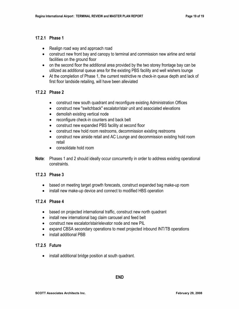
Regina International Airport : TERMINAL REVIEW and MASTER PLAN REPORT Page 19 of 19
SCOTT Associates Architects Inc. February 29, 2008
17.2.1 Phase 1
Realign road way and approach road construct new front bay and canopy to terminal and commission new airline and rental facilities on the ground floor on the second floor the additional area provided by the two storey frontage bay can be utilized as additional queue area for the existing PBS facility and well wishers lounge At the completion of Phase 1, the current restrictive re check-in queue depth and lack of first floor landside retailing, will have been alleviated
17.2.2 Phase 2
construct new south quadrant and reconfigure existing Administration Offices construct new "switchback" escalator/stair unit and associated elevations demolish existing vertical node reconfigure check-in counters and back belt construct new expanded PBS facility at second floor construct new hold room restrooms, decommission existing restrooms construct new airside retail and AC Lounge and decommission existing hold room retailconsolidate hold room
Note: Phases 1 and 2 should ideally occur concurrently in order to address existing operational constraints.
17.2.3 Phase 3
based on meeting target growth forecasts, construct expanded bag make-up room install new make-up device and connect to modified HBS operation
17.2.4 Phase 4
based on projected international traffic, construct new north quadrant install new international bag claim carousel and feed belt construct new escalator/stair/elevator node and new PIL expand CBSA secondary operations to meet projected inbound INT/TB operations install additional PBB
17.2.5 Future
install additional bridge position at south quadrant.
END
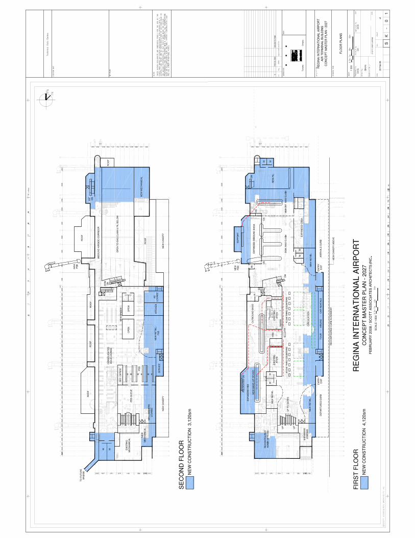
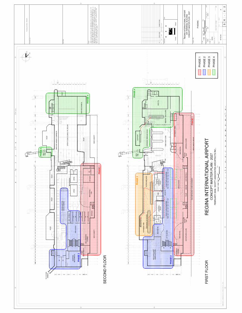
AIRPORT MASTER PLAN 2007-2027 – REGINA INTERNATIONAL AIRPORT REGINA, SK –FINAL REPORT
October, 2008 Pryde Schropp McComb, Inc./SEA/DMA/SCOTT
APPENDIX D
Apron I and II Expansion/Restrictions Analysis
AIRPORT MASTER PLAN 2007-2027 – REGINA INTERNATIONAL AIRPORT REGINA, SK – FINAL REPORT
Pryde Schropp McComb, Inc./SEA/DMA/SCOTT October, 2008

AIRPORT MASTER PLAN 2007-2027 – REGINA INTERNATIONAL AIRPORT REGINA, SK –FINAL REPORT
October, 2008 Pryde Schropp McComb, Inc./SEA/DMA/SCOTT
)
The larger wide-body aircraft tail heights come very close to the runway height protection surfaces on Apron I and II
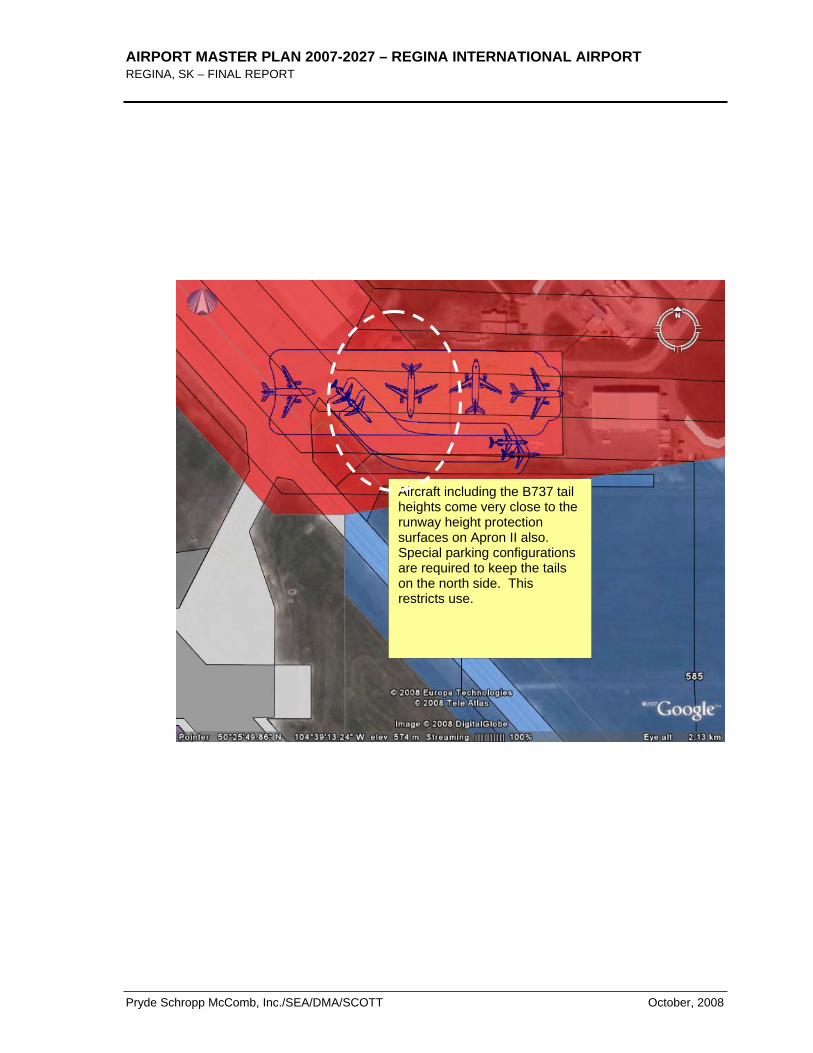
AIRPORT MASTER PLAN 2007-2027 – REGINA INTERNATIONAL AIRPORT REGINA, SK – FINAL REPORT
Pryde Schropp McComb, Inc./SEA/DMA/SCOTT October, 2008
Aircraft including the B737 tail heights come very close to the runway height protection surfaces on Apron II also. Special parking configurations are required to keep the tails on the north side. This restricts use.
AIRPORT MASTER PLAN 2007-2027 – REGINA INTERNATIONAL AIRPORT REGINA, SK –FINAL REPORT
October, 2008 Pryde Schropp McComb, Inc./SEA/DMA/SCOTT
APPENDIX E
City of Regina Zoning Bylaw Excerpt

AIRPORT MASTER PLAN 2007-2027 – REGINA INTERNATIONAL AIRPORT REGINA, SK – FINAL REPORT
Pryde Schropp McComb, Inc./SEA/DMA/SCOTT October, 2008

AIRPORT MASTER PLAN 2007-2027 – REGINA INTERNATIONAL AIRPORT REGINA, SK –FINAL REPORT
October, 2008 Pryde Schropp McComb, Inc./SEA/DMA/SCOTT