REFERRAL OF A PROJECT FOR A DECISION ON THE NEED FOR ...
35
Version 3: January 2007 REFERRAL OF A PROJECT FOR A DECISION ON THE NEED FOR ASSESSMENT UNDER THE ENVIRONMENT EFFECTS ACT 1978 REFERRAL FORM The Environment Effects Act 1978 provides that where proposed works may have a significant effect on the environment, either a proponent or a decision-maker may refer these works (or project) to the Minister for Planning for advice as to whether an Environment Effects Statement (EES) is required. This Referral Form is designed to assist in the provision of relevant information in accordance with the Ministerial Guidelines for assessment of environmental effects under the Environment Effects Act 1978 (Seventh Edition, 2006). Where a decision-maker is referring a project, they should complete a Referral Form to the best of their ability, recognising that further information may need to be obtained from the proponent. It will generally be useful for a proponent to discuss the preparation of a Referral with the Department of Planning and Community Development (DPCD) before submitting the Referral. If a proponent believes that effective measures to address environmental risks are available, sufficient information could be provided in the Referral to substantiate this view. In contrast, if a proponent considers that further detailed environmental studies will be needed as part of project investigations, a more general description of potential effects and possible mitigation measures in the Referral may suffice. In completing a Referral Form, the following should occur: Mark relevant boxes by changing the font colour of the ‘cross’ to black and provide additional information and explanation where requested. As a minimum, a brief response should be provided for each item in the Referral Form, with a more detailed response provided where the item is of particular relevance. Cross-references to sections or pages in supporting documents should also be provided. Information need only be provided once in the Referral Form, although relevant cross-referencing should be included. Responses should honestly reflect the potential for adverse environmental effects. A Referral will only be accepted for processing once DPCD is satisfied that it has been completed appropriately. Potentially significant effects should be described in sufficient detail for a reasonable conclusion to be drawn on whether the project could pose a significant risk to environmental assets. Responses should include: - a brief description of potential changes or risks to environmental assets resulting from the project; - available information on the likelihood and significance of such changes; - the sources and accuracy of this information, and associated uncertainties. Any attachments, maps and supporting reports should be provided in a secure folder with the Referral Form. A CD or DVD copy of all documents will be needed, especially if the size of electronic documents may cause email difficulties. Individual documents should not exceed 2MB. A completed form would normally be between 15 and 30 pages in length. Responses should not be constrained by the size of the text boxes provided. Text boxes should be extended to allow for an appropriate level of detail. The form should be completed in MS Word and not handwritten. The party referring a project should submit a covering letter to the Minister for Planning together with a completed Referral Form, attaching supporting reports and other information that may be relevant. This should be sent to:
Transcript of REFERRAL OF A PROJECT FOR A DECISION ON THE NEED FOR ...

Version 3: January 2007
REFERRAL OF A PROJECT FOR A DECISION ON THE NEED FOR ASSESSMENT UNDER THE ENVIRONMENT EFFECTS ACT 1978
REFERRAL FORM The Environment Effects Act 1978 provides that where proposed works may have a significant effect on the environment, either a proponent or a decision-maker may refer these works (or project) to the Minister for Planning for advice as to whether an Environment Effects Statement (EES) is required.
This Referral Form is designed to assist in the provision of relevant information in accordance with the Ministerial Guidelines for assessment of environmental effects under the Environment Effects Act 1978 (Seventh Edition, 2006). Where a decision-maker is referring a project, they should complete a Referral Form to the best of their ability, recognising that further information may need to be obtained from the proponent.
It will generally be useful for a proponent to discuss the preparation of a Referral with the Department of Planning and Community Development (DPCD) before submitting the Referral.
If a proponent believes that effective measures to address environmental risks are available, sufficient information could be provided in the Referral to substantiate this view. In contrast, if a proponent considers that further detailed environmental studies will be needed as part of project investigations, a more general description of potential effects and possible mitigation measures in the Referral may suffice.
In completing a Referral Form, the following should occur:
Mark relevant boxes by changing the font colour of the ‘cross’ to black and provide additional information and explanation where requested.
As a minimum, a brief response should be provided for each item in the Referral Form, with a more detailed response provided where the item is of particular relevance. Cross-references to sections or pages in supporting documents should also be provided. Information need only be provided once in the Referral Form, although relevant cross-referencing should be included.
Responses should honestly reflect the potential for adverse environmental effects. A Referral will only be accepted for processing once DPCD is satisfied that it has been completed appropriately.
Potentially significant effects should be described in sufficient detail for a reasonable conclusion to be drawn on whether the project could pose a significant risk to environmental assets. Responses should include:
- a brief description of potential changes or risks to environmental assets resulting from the project;
- available information on the likelihood and significance of such changes;
- the sources and accuracy of this information, and associated uncertainties.
Any attachments, maps and supporting reports should be provided in a secure folder with the Referral Form.
A CD or DVD copy of all documents will be needed, especially if the size of electronic documents may cause email difficulties. Individual documents should not exceed 2MB.
A completed form would normally be between 15 and 30 pages in length. Responses should not be constrained by the size of the text boxes provided. Text boxes should be extended to allow for an appropriate level of detail.
The form should be completed in MS Word and not handwritten.
The party referring a project should submit a covering letter to the Minister for Planning together with a completed Referral Form, attaching supporting reports and other information that may be relevant. This should be sent to:

Version 4: September 2007
ii
Postal address Couriers
Minister for Planning Minister for Planning
GPO Box 2392 Level 7, 1 Spring Street
MELBOURNE VIC 3001 MELBOURNE VIC 3001
In addition to the submission of the hardcopy to the Minister, separate submission of an electronic copy of the Referral via email to [email protected] is encouraged. This will assist the timely processing of a referral.
_____________________________________________________________
Version 3: January 2007
PART 1 PROPONENT DETAILS, PROJECT DESCRIPTION & LOCATION
1. Information on proponent and person making Referral
Name of Proponent: VicRoads
Authorised person for proponent: Mal Kersting
Position: Regional Director Northern
Postal address: 53-61 Lansell Street, East Bendigo, 3550
Email address: [email protected]
Phone number: (03) 5434 5000
Facsimile number: (03) 5434 5003
Person who prepared Referral: Gina Solomon
Position: Planning Studies Manager
Organisation: VicRoads
Postal address: Level 1, 3 Prospect Hill Road, Camberwell, 3124
Email address: [email protected]
Phone number: (03) 9811 8210
Facsimile number: (03) 9811 8248
Available industry & environmental expertise: (areas of ‘in-house’ expertise & consultancy firms engaged for project)
Project Management – VicRoads, Planning Investigations
Specialist Studies Undertaken:
Noise Monitoring and Modelling Assessment – Renzo Tonin & Associates Pty Ltd
Detailed Flora and Fauna Assessment – Ecology & Heritage Partners Pty Ltd
Traffic Modelling and Economic Assessment – AECOM Australia Pty Ltd
Post-contact Heritage Study – ACHM Pty Ltd
Detailed Aboriginal Cultural Heritage Study – ACHM Pty Ltd
Land Use and Regional Economy Study – URS Pty Ltd
Geotechnical Study – VicRoads Technical Consulting
Landscape and Visual Assessment – AECOM Australia Pty Ltd
Social Impact Assessment – AECOM Australia Pty Ltd
Hydrology Study – AECOM Australia Pty Ltd
2. Project – brief outline
Project title: Kilmore Wallan Bypass
Project location: (describe location with AMG coordinates and attach A4/A3 map(s) showing project site or investigation area, as well as its regional and local context) The Project is located within the Shire of Mitchell, a council area encompassing Kilmore, Wallan, Seymour, Beveridge, Broadford and Tallarook. The corridors which have been investigated are based around the townships of Kilmore and Wallan and include the hamlet of Kilmore East. Refer to VicRoads Country Directory Map 60 for the project location. Refer to Attachment 1 for the map of the five corridors which have been investigated. Attachment 1: Map of the corridors

Version 4: September 2007
2
The five corridors extend north to approximately the intersection of the Northern Highway with Broadford-Kilmore Road. To the south, the corridors extend to approximately the intersection of the Hume Freeway and Epping-Kilmore Road, known as the Wandong Interchange. The corridors are bounded in the west by Kings/Paynes Road and the Hume Freeway in the east. All alignment options which have been investigated commence in the north at the intersection of the Northern Highway and Kilmore-Broadford Road (318774E, 5873414N). The end points of the options are as follows: Sunday Creek Road Option intersects with the Hume Freeway at Clonbinane
(327600E, 5871570N); Dry Creek Option intersects with the Hume Freeway north of Wandong (324787E,
5865425N); and The other three options (Quinns Road, O’Gradys Road and the Western Option) intersect with
the Hume Freeway at the existing interchange at Wandong (324800E, 5864370N). Attachment 2: Map of the options
Short project description (few sentences): The Kilmore Wallan Bypass will connect to the Northern Highway north of Kilmore with the Hume Freeway to the east of Kilmore. A bypass of Wallan is achieved by utilising the existing Hume Freeway whereas Kilmore would be bypassed via a new alignment between that Freeway and the intersection of the Northern Highway and Kilmore-Broadford Road. The project will construct a single two lane carriageway highway bypass of Kilmore and Wallan by 2017 and will reserve and acquire sufficient land for possible future widening to a dual carriageway. The bypass will reduce traffic, including trucks through the town centres and improve road safety and functionality in the town centres.
3. Project description
Aim/objectives of the project (what is its purpose / intended to achieve?):
Project objectives of the Kilmore Wallan Bypass are defined as follows:
Improve road safety and enhance the functionality of the road network in town centres; Improve town amenity by removing bypassable traffic, minimising noise and visual
impacts of the new road and minimising impacts on key community facilities during construction and operation of the bypass;
Improve transport connectivity, freight movement and efficiency for bypassable traffic; To achieve acceptable consistency with current and proposed land uses and support
the long term planning and development of the Kilmore-Wallan area; Minimise displacement and severance of communities, community facilities and
agricultural land, to the extent practicable; Avoid or minimise impacts on areas and features of ecological significance, to the
extent practicable; Avoid or minimise impacts on areas and features of heritage significance, to the extent
practicable; Avoid or minimise impacts on water quality, hydrology and floodplain to the extent
practicable; and Provide a balanced outcome giving consideration to environmental, economic and
social factors.
Background/rationale of project (describe the context / basis for the proposal, eg. for siting): Kilmore and Wallan are experiencing population growth rates amongst the highest in Victoria. The DPCD website ‘Victoria in Future’ indicates annual average growth rates within the Shire of Mitchell of 5.0% compared with a state average 1.3%. Further work has been undertaken by AECOM Australia Pty Ltd as part of the Transport Modelling for this project. The resultant growth rates within the study area for 2011-2021 are estimated to be 5.4% per annum. Refer to Attachment 3 the Detailed Traffic Modelling Study Section 4.1 Table 3. These figures use data compiled by SGS Economics and Planning during 2011-12 which was used to develop the traffic

Version 4: September 2007
3
model. Attachment 3: Detailed Transport Modelling Study In addition to increasing levels of local traffic, as an important industrial centre in the region, Kilmore is subjected to heavy vehicle and freight traffic, as well as tourists heading north into Echuca and New South Wales. Truck and freight volumes are expected to increase with the increase in the statewide freight task. Fundamentally, the community has expressed concerns with the volume of freight traffic, especially through the narrow (20m) road reservation in Sydney Street, Kilmore. As a result of these factors the Victorian State Government, determined that a bypass of Kilmore and Wallan should be considered. Over the last 10 years, in consultation with the local community, various studies have explored potential options for this bypass. The studies began with the Northern Highway B75 Corridor Strategy in 1998, followed by:
The Kilmore Arterial Road Network Study (KARNS) in 2002; The Northern Highway Duplication Study in 2005; The Kilmore Wallan Bypass Options Examination in 2008; and Linking Kilmore in 2009.
For further information regarding these studies, see Section 4 of this referral.
Main components of the project (nature, siting & approx. dimensions; attach A4/A3 plan(s) of site layout if available): The northern connection of the bypass will be located between the intersection of the Northern Highway and Broadford-Kimore Road and depending on the option selected will intersect with the Hume Freeway at either Clonbinane, north of Wandong or at the existing interchange at Wandong. All five options investigated in the planning study commence at a new roundabout at the intersection of the Northern Highway and the Broadford-Kilmore Road north of Kilmore:
Sunday Creek Option: is the northernmost option which passes through the equine precinct to the north of Kilmore, then travels through rural farming land and low density residential housing in Kilmore east before crossing over the Melbourne-Sydney rail line. The route then generally follows the existing Sunday Creek Road alignment and traverses hilly rural agricultural land, connecting to the Hume Freeway at the existing interchange at Clonbinane. Approximate route length is 11.0 kilometres.
Dry Creek Option: passes through the equine precinct to the north of Kilmore, then travels through rural farming land and low density residential housing in Kilmore east before crossing over the Melbourne-Sydney rail line. The route runs through hilly rural farm land, then into sideling cut alongside Dry Creek, through tree plantations, crossing over the Kilmore miniature railway and alongside The Dene. This option then connects onto the Hume Freeway at new ramps north of the existing Wandong interchange. Approximate route length is 11.2 kilometres.
O’Gradys Road Option: passes through the equine precinct to the north of Kilmore, then travels through rural farming land and low density residential housing in Kilmore east before crossing over the Melbourne-Sydney rail line. The route then passes through agricultural land before crossing over the Melbourne-Sydney rail line and Dry Creek. The route then runs through undulating rural living west of the rail line, then generally follows the existing alignment of O’Gradys Road. The route passes behind a row of rural lifestyle housing adjacent to the Hume Freeway before joining the Freeway via an upgraded interchange at Wandong. Approximate route length is 12.3 kilometres.
Quinns Road Option: passes through the equine precinct to the north of Kilmore, then crosses over the Kilmore East Road to the east of the Kilmore horse racing precinct, Kilmore cricket club and Kilmore golf course, passing through the lower part of the Monument Hill reserve at or near existing surface levels. The option then enters a substantial cut as the route passes east of Anderson road adjacent to residential housing, before entering rural agricultural land alongside Quinns Road. At the junction with the Epping-Kilmore Road the route turns east and then generally follows the alignment of the existing arterial road, except at Broadhurst Creek where a new alignment cuts across

Version 4: September 2007
4
rural land to improve the alignment over the creek. This route then joins the Hume Freeway at a modified interchange at Wandong. This option includes an upgraded connection to the Northern Highway south of Kilmore. Approximate route length is 12.7 kilometres.
Western Option: passes through rural agricultural land to the west and alongside the waste water treatment plant. The option crosses Willowmavin Road and then runs alongside Kings Lane to a roundabout at the Lancefield Road intersection. The alignment then deviates through rural living properties before entering agriculture land adjacent to Paynes Road and Gehreys Lane. The option crosses the Northern Highway at a new roundabout and then generally follows the alignment of the existing arterial road, except at Broadhurst Creek, where a new alignment cuts across rural land to improve the alignment over the creek. This option then joins the Hume Freeway at a modified interchange at Wandong. Approximate route length is 17.1 kilometres.
The alignments are shown in Attachment 2: Map of the options.
Ancillary components of the project (eg. upgraded access roads, new high-pressure gas pipeline; off-site resource processing): Sunday Creek Option: A section of Broadford Wandong Road would be realigned to have access to the bypass. A section of Dry Creek and Sunday Creek Road would be realigned to have access onto the bypass. A new connection is proposed between Wallders Road and Trainers Drive. Both Bremner Place and Kellys Lane would be realigned and extended for access onto the bypass. Dry Creek Option: An extension of Sunday Creek Road directly onto the bypass would be provided. A new connection is proposed between Wallders Road and Trainers Drive. Both Bremner Place and Kellys Lane are realigned and extended for access onto the bypass. O'Gradys Road Option: A new connection is proposed between O'Gradys Road and Sir Leo Curtis Drive. A new connection is proposed between Wallders Road and Trainers Drive. Both Bremner Place and Kellys Lane would be realigned and extended for access onto the bypass. Quinns Road Option: A new access road would be provided to the Goulburn Murray Water, town water supply storage facility, which commences adjacent to Tootle Street. A section of Hunts Road would be relocated to the eastern side of the bypass. A new connection is proposed between Wallders Road and Trainers Drive. A new section of Wandong Rd is proposed with access directly onto the bypass. Western Option: A new section of Wandong Road is proposed with access directly onto the bypass. A new connection is proposed between Gehreys Lane and Paynes Road.
Key construction activities: The key construction activities shall involve civil works and a variety of structural works that include; large culverts, creek crossings, rail crossing, pedestrian underpasses and major interchanges. Other construction activities will include clearing of vegetation, general earthworks (including topsoil stripping, excavation, filling and topsoil spreading), relocation of utility services, drainage installation, landscaping, lighting and signage. Significant earthworks are required on all options (including excavation) as a result of very hilly terrain throughout the area.
Key operational activities:
The key operational activities will include the movement of passenger vehicles and freight via high standard road infrastructure, whilst minimising interaction with local traffic in the central shopping areas of Kilmore and Wallan townships. Ongoing road maintenance consistent with the practices and standards of VicRoads including the maintenance of landscape, stormwater drains, road pavement, bridges, electrical assets, road furniture and line markings.

Version 4: September 2007
5
Key decommissioning activities:
Not applicable.
Is the project an element or stage in a larger project?
No Yes If yes, please describe: The overall project strategy for delivery of all stages and components; the concept design for the overall project; and the intended scheduling of the design and development of project stages).
Is the project related to any other past, current or mooted proposals in the region?
No Yes If yes, please identify related proposals.
The proposed bypass project is a stand-alone proposal that has evolved through a series of road network investigations, as summarised in Section 4, it is not dependant on other projects.
4. Project alternatives
Brief description of key alternatives considered to date (eg. locational, scale or design alternatives. If relevant, attach A4/A3 plans):
Over the last 10 years, in consultation with the local community, various studies have explored potential options for the Kilmore Wallan Bypass. The studies began with the Northern Highway B75 Corridor Strategy in 1998, followed by; the Kilmore Arterial Road Network Study (KARNS) in 2002, the Northern Highway Duplication Study in 2005, the Kilmore Wallan Bypass Options Examination in 2008, and Linking Kilmore in 2009. An outline of the content of these studies and their findings is provided below:
The Northern Highway B75 Corridor study identified future highway improvements including the need to consider construction of a Kilmore Bypass if warranted following a detailed planning study.
The Kilmore Arterial Road Network Study (KARNS) was conducted in 2002 and assessed the need for a bypass near Kilmore. The study concluded that a collector distributor network should be developed to address local traffic demand through central Kilmore.
In December 2005, a Planning Study was commenced which investigated the duplication of the Northern Highway between Kilmore and the Hume Freeway. The study found that this section of the Northern Highway would require additional capacity due to the Kilmore growth rate and its proximity to Melbourne.
In 2008, the Kilmore Wallan Bypass Options Examination considered preliminary planning investigations into bypass options in the Kilmore Wallan area. In consultation with the local community, VicRoads developed and investigated the feasibility of 11 potential bypass options.
In October 2009, the Mitchell Shire Council met with the former State Government and prepared a list of improvement projects as the basis for a Memorandum of Understanding (MoU), to be known as the ‘Linking Kilmore’ package of works that would address the heavy truck and general congestion in Sydney Street, local traffic needs and revitalise the town centre. The Linking Kilmore package of works included as its principal project, the development of a new Link Road along Conway/Johns Streets that had been previously identified in Council’s Kilmore Access and Movement Study report, and a similar alignment to Option G that was investigated in the Kilmore-Wallan Bypass Options Examination in 2008.
In early 2011, the Government directed VicRoads to investigate a suitable bypass of Kilmore and Wallan as its priority to be constructed by 2017. The Government also directed VicRoads to complete planning activities for future capacity needs of the Northern Highway, south of Kilmore. The current Kilmore-Wallan Bypass Planning Study has investigated the better performing options previously considered in the Kilmore Wallan Bypass Options Examination (2008). The options considered for more detailed investigation were those that met the Government’s commitment of providing a bypass of both Kilmore and Wallan and those that were effective in reducing truck and through traffic in Kilmore and Wallan. Options previously considered in the Kilmore Wallan

Version 4: September 2007
6
Bypass Options Examination (2008) were selected as the basis for the current detailed planning investigation. These options were refined to become:
Sunday Creek Option Dry Creek Option O’Gradys Road Option Quinns Road Option (including connection to the Northern Highway south of Kilmore)
Note: Following feedback from the community the Minister for Roads requested that a suitable option to the west of Kilmore be developed and included in the current planning investigations.
Western Option (was developed utilising a combination of options from the Kilmore Wallan Bypass Options Examination (2008).
VicRoads has reviewed the findings of the studies and considered the views of key stakeholders and community feedback and decided that the Dry Creek, Quinns Road and Western Options be shortlisted for further consideration in the Kilmore Wallan Bypass planning process and that the Sunday Creek Road and O’Gradys Road Options be eliminated from further consideration. In reaching the decision on which of the five options should be taken forward, the ability of the options to effectively reduce the amount of truck and general traffic in Kilmore and Wallan was one of the key considerations. In addition, VicRoads has recognized that the Quinns Road option is the best performing option in meeting the key objective of reducing Northern Highway traffic through Kilmore and Wallan town centres. The Sunday Creek Option was not considered for further investigation in the planning process as it was not effective in reducing traffic in Kilmore and Wallan and had the highest impact on native vegetation. The O’Gradys Road Option similarly had the second highest impact on native vegetation, high property impacts along O’Gradys Road and similar traffic performance to the Dry Creek Option which has substantially less native vegetation and property impacts. The three options that form the basis of this referral are;
Dry Creek Quinns Road Western
Brief description of key alternatives to be further investigated (if known): VicRoads has decided that the Dry Creek Option, Quinns Road Option and the Western Option would be considered further in the Kilmore Wallan Bypass planning process. Refer to Attachment 4 for the map of the options to be considered further in the planning process. Attachment 4: Map of options to be considered further in the planning process Dry Creek Option: The option connects to the Hume Freeway just north of the existing Wandong Interchange via two southerly oriented ramps. The bypass option then runs parallel to, and east of, the Melbourne-Sydney Railway and Dry Creek through tree plantations and farming land. The option crosses over the Melbourne-Sydney Railway at the Kilmore East hamlet and then runs parallel to, and north of Kilmore East Road. It then continues in a north west direction through the residential and farming areas before connecting to the Northern Highway, south of the Broadford-Kilmore Road turnoff with a large diameter roundabout. There are local road connections at Kilmore East Road and Kellys Lane. The Northern Highway and Broadford-Kilmore Road intersection would also be upgraded to a large diameter roundabout. Quinns Road Option: The option connects to the Hume Freeway at the existing Wandong interchange, requiring an upgrade of the existing interchange. The bypass option then generally follows the existing Epping-Kilmore Road and includes a connection to the Northern Highway south of Kilmore with a large roundabout. The bypass option then runs northwards parallel to, and east of Quinns Road and Andersons Road. The option runs along the western base of the Monument Hill Reserve to the east side of the golf course and race track along Hunts Road, requiring relocation of Hunts Road access along the east side of the bypass. The option then

Version 4: September 2007
7
crosses Kilmore East Road and continues north-west through rural residential and farming areas before connecting to the Northern Highway south of the Broadford-Kilmore Road turnoff. There are local road connections at O’Gradys Road, Mathiesons Road, Millard Road, Quinns Road, McIvors Road, Tootle Street, Monument Hill Drive, and Kellys Lane. The Kilmore-Broadford Road intersection would also be upgraded to a large roundabout.
Western Option: The option connects to the Hume Freeway at the existing Wandong Interchange, requiring an upgrade of the existing interchange. The bypass option then generally follows the existing Epping-Kilmore Road connecting to the Northern Highway south of Kilmore with a large diameter roundabout. The bypass option continues westward running parallel to, and south of Gehreys Lane, before turning northward at Paynes Road and running parallel to and west of Paynes Road. The option connects to the Kilmore-Lancefield Road with a large diameter roundabout. The option then continues northward running parallel to, and west of, Kings Lane, before turning north-east past the waste water treatment facility before connecting to the Northern Highway at the Broadford- Kilmore Road intersection with a large diameter roundabout. There are local road connections at Broadhurst Lane, O’Gradys Road, Mathiesons Road, Millard Road, Quinns Road, Mill Road, Fitzgerald Road, McDougalls Road, Willowmavin Road and Costello’s Road. General comments – All options The area to the east of Kilmore generally comprises steep hilly terrain providing challenging road alignment choices to achieve suitable road gradients for truck travel. If this project is to successfully reduce truck traffic in Kilmore and Wallan, the bypass must provide an attractive alternative to travelling through central Kilmore and Wallan along the Northern Highway. The options involve the upgrade of existing roads and the construction of new sections of road. The use of local roads has been avoided with the exception of Quinns and Hunts Road. It is expected that structures shall be erected (where applicable) at the crossings of Kilmore, Broadhurst and Dry Creeks, being either bridge structures or culverts. Major structures are also required over the Sydney – Melbourne Railway as underpasses are not feasible due to the proximity of Dry Creek floodplain. Major structures also include an overpass of Kilmore East Road and an interchange upgrade at Wandong. The Dry Creek Option proposes a new half diamond interchange north of the existing Wandong interchange. Safe intersection connections shall be made at points along the bypass route to connect local and arterial roads to the bypass, thereby improving traffic flow and accessibility for local traffic. Some large farming properties will have direct access to the new road however consideration has been given to service roads for controlling access and improving the safe operation of the bypass where required. The concept design has been developed with an alignment to avoid and minimise impacts on key constraints (in both 2 lane and potential future 4 lane configurations). Subject to the outcome of the environmental, economic and social investigations, the concept design could be modified to address certain impacts.
5. Proposed exclusions
Statement of reasons for the proposed exclusion of any ancillary activities or further project stages from the scope of the project for assessment:
None
6. Project implementation
Implementing organisation (ultimately responsible for project, ie. not contractor):
VicRoads is the authority responsible for the development of proposed options for the Kilmore-Wallan Bypass and for management of the project during construction. Under the Road Management Act 2004, VicRoads will be the Responsible Road Authority for management and maintenance of the bypass route as an Arterial road. Implementation timeframe:

Version 4: September 2007
8
The Victorian State Government has committed to deliver the Kilmore Wallan Bypass by 2017. The planning investigation is proposed to be completed by early 2014 to ensure construction would be completed in 2017 to meet the Government’s commitment. Proposed staging (if applicable):
The project considers a 2 lane two way road for construction with enough land reserved and acquired to allow for future capacity enhancement to 4 lanes if required. Based on current traffic forecasts, it is likely that duplication will not be necessary for the forecast period (ie. well beyond the 2041 year predictions).
7. Description of proposed site or area of investigation
Has a preferred site for the project been selected?
No Yes If no, please describe area for investigation.
If yes, please describe the preferred site in the next items (if practicable).
General description of preferred site, (including aspects such as topography/landform, soil types/degradation, drainage/ waterways, native/exotic vegetation cover, physical features, built structures, road frontages; attach ground-level photographs of site, as well as A4/A3 aerial/satellite image(s) and/or map(s) of site & surrounds, showing project footprint): Topography/Landform: The topography of the land varies across the corridors and surrounding area. In the area between the township of Kilmore and the Hume Freeway, the land is characterised by hilly sedimentary rises with steep grades. Ridges are present in this region as well as a variety of drainage lines some with active floodplains. Some ridges are capped with basalt (actively being quarried). There are large areas that surround Kilmore to the south and west that are relatively flat to undulating. Drainage/Waterways: Collectively, the proposed alignments intersect Kilmore Creek, Dry Creek and Broadhurst Creek and the minor tributaries to the creeks. They are small to medium waterways generally with seasonal water flows and some permanent waterholes. Dry Creek is the largest waterway within the study area and is subject to substantial increases in short term flows during flood events. The waterway is well defined with steep surrounding terrain, thus the difference in flood extents between 100 and 20 ARI flood event is not significant. The study area is part of the Goulbourn Broken Catchment and much of the area is protected by an Erosion Management Overlay (EMO). Native/Exotic Vegetation: A large part of each of the corridors support native vegetation, particularly east of Kilmore. These areas vary in quality and ecological vegetation class. Patches include vegetation confined to existing road reserves, scattered trees, large recreational reserves (Monument Hill) and riparian vegetation.
Site area
The functional design for the road and bridge works shows an approximate development footprint for the ultimate duplicated facility as listed below for each option:
Dry Creek Option – 165 Ha Quinns Road Option – 173 Ha Western Option – 197 Ha
Route Length
The length of each option is as follows:
Dry Creek Option – 11.2 km Quinns Road Option – 12.7 km Western Option – 17.1 km
A nominal 60 metres road reserve width for each route corridor has been proposed for flat terrain. This would allow enough room for future widening if required along with setbacks for safety and maintenance purposes. In very hilly terrain or where access restoration is required, the road

Version 4: September 2007
9
reserve width could be expected to be much wider than 60 metres. Reserve widths in excess of 200 metres could be required for the bypass to lower the slope (grade) of the road for vehicles to more easily navigate. This is achieved by either cutting through the hills/ridges or building the road up in valleys. The resulting footprint is larger due to the embankments/cuts required to achieve this.
Current land use and development: The following is a description of the current land use that could be impacted by each of the three options under consideration. The numbers of dwellings (refers to the dwelling no longer being habitable) and landholders affected (can be minimal acquisition, substantial losses or severance of parcels) are based on current design development and are subject to change. Dry Creek Option: The land uses impacted by this option includes rural living, farming, rail/transport corridor (Sydney-Melbourne Railway), public land used for leisure (elevated structure over miniature railway), private eucalypt timber plantations and Dry Creek floodplain. This option also passes through/near residential areas at Kilmore East and the rural living ‘equine precinct’ north of Kilmore. Ten (10) residential dwellings and thirty five (35) properties are directly affected by this option. Quinns Road Option: The land uses impacted by this option includes existing road reserve (Epping-Kilmore Road) and abutting farm land, rural living and farming. In the vicinity of Anderson Road this option impacts on farming land adjacent to residential areas, the option then utilises treed public land in the lower parts of Monument Hill reserve to the east of the Kilmore public golf course and Kilmore Cricket club. The option then passes through low density residential properties adjacent to Hunts Road and the Kilmore race course and the rural living ‘equine precinct’ north of Kilmore. Fourteen (14) residential dwellings and seventy two (72) properties are directly affected by this option. Western Option: The land uses impacted by this option includes existing road reserve (Epping-Kilmore Road) and abutting farm land, rural living and farming. Along Gehreys Lane adjacent to a high pressure gas pipeline, and adjacent to Paynes Road and Kings Lane this option impacts on farming land. The option then crosses through farming and special use land along the edge of the wastewater treatment plant. Six (6) residential dwellings and fifty three (53) properties are directly affected by this option. Attachment 5: Land Use and Regional Economy Study
Description of local setting (eg. adjoining land uses, road access, infrastructure, proximity to residences & urban centres): The following is a description of the land use that surrounds each of the three options under consideration: Dry Creek Option: The option runs parallel to the Melbourne-Sydney rail reserve and floodplain areas along Dry Creek between the Hume Freeway and Kilmore East. These areas are surrounded by farmland and eucalypt plantations. This option runs south of the large quarries and avoids the Kilmore East hamlet and railway station, continuing through farming land and is surrounded by rural living lifestyle (equine) properties. The option avoids the more densely populated areas north of Kilmore. Quinns Road Option: Commencing at the Wandong Interchange the option runs along the boundary of some rural living lifestyle properties and farming land until reaching the Monument Hill Reserve. The option avoids the high density residential areas in the vicinity of Anderson Road south of Kilmore. There is no direct physical impact on the Kilmore golf course, the cricket oval or the Kilmore Racecourse. The option traverses the lower (elevation) section of the Monument Hill Reserve which is used for passive recreation. Access restoration will be provided to ensure ongoing access to substantial sections of the reserve enabling ongoing usage. The option then continues through residential areas fronting Hunts Road and is surrounded by large rural living lifestyle (equine) properties. The option avoids the more densely populated areas north of Kilmore. Western Option: Commencing at the Wandong Interchange the option runs along the boundary
Version 4: September 2007
10
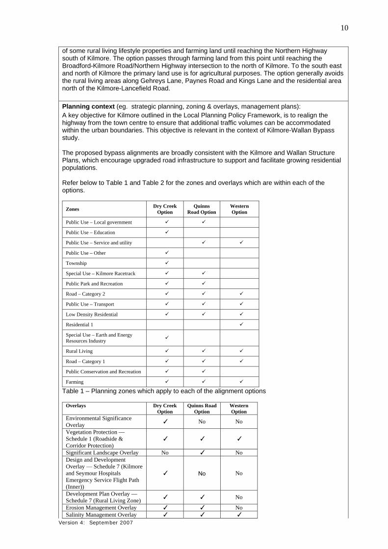
of some rural living lifestyle properties and farming land until reaching the Northern Highway south of Kilmore. The option passes through farming land from this point until reaching the Broadford-Kilmore Road/Northern Highway intersection to the north of Kilmore. To the south east and north of Kilmore the primary land use is for agricultural purposes. The option generally avoids the rural living areas along Gehreys Lane, Paynes Road and Kings Lane and the residential area north of the Kilmore-Lancefield Road. Planning context (eg. strategic planning, zoning & overlays, management plans): A key objective for Kilmore outlined in the Local Planning Policy Framework, is to realign the highway from the town centre to ensure that additional traffic volumes can be accommodated within the urban boundaries. This objective is relevant in the context of Kilmore-Wallan Bypass study. The proposed bypass alignments are broadly consistent with the Kilmore and Wallan Structure Plans, which encourage upgraded road infrastructure to support and facilitate growing residential populations. Refer below to Table 1 and Table 2 for the zones and overlays which are within each of the options.
Zones Dry Creek
Option Quinns
Road Option Western Option
Public Use – Local government
Public Use – Education
Public Use – Service and utility
Public Use – Other
Township
Special Use – Kilmore Racetrack
Public Park and Recreation
Road – Category 2
Public Use – Transport
Low Density Residential
Residential 1
Special Use – Earth and Energy Resources Industry
Rural Living
Road – Category 1
Public Conservation and Recreation
Farming
Table 1 – Planning zones which apply to each of the alignment options
Overlays Dry Creek Option
Quinns Road Option
Western Option
Environmental Significance Overlay
✓ No No
Vegetation Protection — Schedule 1 (Roadside & Corridor Protection)
✓ ✓ ✓
Significant Landscape Overlay No ✓ NoDesign and Development Overlay — Schedule 7 (Kilmore and Seymour Hospitals Emergency Service Flight Path (Inner))
✓ No No
Development Plan Overlay — Schedule 7 (Rural Living Zone)
✓ ✓ No
Erosion Management Overlay ✓ ✓ NoSalinity Management Overlay ✓ ✓ ✓

Version 4: September 2007
11
Wildfire Management Overlay ✓ ✓ ✓
Table 2 – Planning overlays which apply to each of the alignment options Attachment 6: Current zoning controls
Local government area(s):
Shire of Mitchell.
8. Existing environment
Overview of key environmental assets/sensitivities in project area and vicinity (cf. general description of project site/study area under section 7):
Native vegetation, Aboriginal Cultural Heritage sites and the current built form and community assets have been identified as key environmental constraints in some areas and these factors have been considered through the option development process. The study area has been subject to historical agricultural land use (land clearing, grazing, cropping) and consists of predominantly introduced vegetation dominated by exotic species. The majority of native vegetation throughout the three corridors and surrounds has been cleared or modified as a result of these activities, and remnant vegetation was generally limited to roadside reserves and the Monument Hill reserve adjacent to the Kilmore Golf Course. Flora Ecology and Heritage Partners (EHP 2012) surveyed a nominal 100m corridor (which included all potential areas where the footprint may be wider) along the eastern alignment options in October 2011. Spring surveys were undertaken in September 2012 for the western option and some areas of the eastern alignment options which had not been previously surveyed. Targeted surveys are currently being undertaken for specific flora and fauna species. There is one previously recorded occurrence of a nationally significant flora species, the Matted Flax-lily Dianella amoena, nearby but outside the three corridors. The Small-flower Wallaby-grass Austrodanthonia monticola, a state significant flora species was previously recorded in several locations along the road reserve of the Northern Highway. There is potential for this species to occur in all of the three corridors which have areas which support indigenous grassland. No nationally or state listed significant flora species were recorded during the current field survey. There is suitable habitat within all alignment options for the nationally significant species, the Matted Flax-lily. There is suitable habitat within all alignment options for three State significant flora species, the Small-flower Wallaby-grass, Slender Bitter-cress and Fringed Sun-orchid. No state significant vegetation communities were recorded during the current field survey and assessment. Six Ecological Vegetation Classes (EVCs) across the Central Victorian Uplands bioregion and Highlands – Northern Fall bioregion were recorded in the three options. The following EVC’s would be affected in each of the options:
Dry Creek Option – Creekline Grassy Woodland (Endangered), Riparian Forest (Vulnerable), Valley Grassy Forest (Vulnerable) and Grassy Dry Forest (Depleted) in the Central Victorian Uplands bioregion;
Quinns Road Option – Riparian Forest (Vulnerable), Valley Grassy Forest (Vulnerable) and Grassy Dry Forest (Depleted) in the Central Victorian Uplands bioregion and Swampy Riparian Woodland (Vulnerable), Grassy Dry Forest (Least Concern), Herb-rich Foothills Forest (Least Concern) and Riparian Forest (Least Concern) in the Highlands- Northern Fall bioregion; and
Western Option – Valley Grassy Forest (Vulnerable) and Grassy Dry Forest (Depleted) in the Central Victorian Uplands bioregion and Herb-rich Foothills Forest (Least Concern),

Version 4: September 2007
12
Riparian Forest (Least Concern) and Grassy Dry Forest (Least Concern) in the Highlands- Northern Fall bioregion.
Fauna No nationally listed significant fauna species were recorded during the current field survey and assessment. According to a local landowner, a farm dam within the Quinn’s Road Option has been stocked with Murray Cod. The species has been stocked and is not likely to be a self-sustaining population. The farm dam is likely to be impacted by the Quinn’s Road Option. There is suitable habitat for nationally significant species including the Golden Sun Moth Synemon plana in areas supporting indigenous grassland (e.g. Valley Grassy Forest and Grassy Dry Forest) within all options. Small Ant Blue Butterfly Acrodipsas myrmecophila and Large Ant Blue Butterfly Acrodipsas brisbanensis may occur within the three options on rare occasions. These species are known from Broadford, which is located near the study area, so there is some potential for them to occur in open forest and woodland where dead stumps or fallen logs are present. There is suitable habitat for the nationally significant Striped Legless Lizard within the Dry Creek Option. Nationally significant Growling Grass Frogs Litoria raniformis may occupy wetlands such as farm dams and still pools along creeklines throughout the three options and Dwarf Galaxias Galaxiella pusilla may also be present in some drainage lines of the three options. The Swift Parrot Lathamus discolor may feed throughout flowering eucalypt woodlands and forests while on route to northern overwintering areas in northern Victoria and New South Wales and the Grey-headed Flying-fox Pteropus poliocephalus may forage opportunistically in wooded areas. However the three options are unlikely to provide permanent or limiting habitat to either of these species. Three state listed significant fauna species, the Hardhead Aythya australis, Brush-tailed Phascogale Phascogale tapoatafa tapoatafa and Brown Treecreeper Climacteris picumnus victoriae were recorded during the current assessment. Woodland or forested habitats within all options may provide habitat to a range of state significant species, including the Southern Toadlet Pseudophrynesemimarmorata and Brown Toadlet Pseudophrynebibronii which are likely to be present in low-lying areas that are subject to inundation. There is suitable habitat within all alignment options for state significant Brush-tailed Phascogale, woodland-dependent bird species and the Victorian Temperate Woodland Bird Community. A range of state significant bird species are also likely to occupy woodland habitats within all the options, including the Brown Treecreeper Climacterispicumnus, Diamond Firetail Stagonopleuraguttata, Hooded Robin Melanodryascucullata and Speckled Warbler Chthonicolasagittatus. Powerful Owl Ninoxstrenua and Barking Owl Ninoxconnivens may also be present in these areas. Wetlands on the lower slopes and flat areas (e.g. farm dams, creeks) may be visited by wetland-dependent species such as Hardhead Aythyaaustralis and Eastern Great Egret Egrettaalba, although the majority of records of these species are from Wallan sewerage treatment ponds. The study area contains a broad range of fauna habitats: remnant woodland and forest, indigenous grassland, scattered trees (which are likely to contain hollows), coarse woody debris, farm dams, creeklines and ephemeral drainage lines. Other fauna habitats include modified and exotic grassland, planted trees and shrubs, and human-made structures (e.g. bridges, dry stone walls). Attachment 7: Detailed Flora and Fauna Study Aboriginal Cultural Heritage
Australian Cultural Heritage Management undertook both a desktop and standard assessment. The desktop assessment identified a total of four previously recorded sites within the study area,
Version 4: September 2007
13
consisting of one isolated artefact and three artefact scatters. During the standard assessment, a further 63 sites were located within the study area. There were no culturally modified scarred trees, culturally modified charcoal, caves, rock shelters or cave entrances located within the study area. Soil profiles within the three corridors have been disturbed by road construction, residential and rural infrastructure construction and ploughing and other agricultural activities. Despite the effect that this ground disturbance has had on any potential subsurface deposits, it is still likely that subsurface deposits are located within the three corridors. Dry Creek Option: There are three previously recorded places within the Dry Creek Option and twenty seven sites recorded during the standard assessment are located within this option. Eight sites (three artefact scatters and five isolated artefacts) would be potentially impacted by the Dry Creek Option. Quinns Road Option: Nine sites recorded during the standard assessment are located within the Quinns Road Option. Two isolated artefacts would be potentially impacted by the Quinns Road Option.
Western Option: Eleven sites recorded during the standard assessment are located within the Western Option. Two isolated artefacts would be potentially impacted by the Western option.
Attachment 8: Detailed Aboriginal Cultural Heritage Study
European Cultural Heritage No archaeologically significant historic sites were located during the fieldwork. One site of local historical significance is located on the Broadford‐Kilmore Road which is outside the three corridors. This site is the Beuhne Memorial. Attachment 9: European Cultural Heritage Study
9. Land availability and control
Is the proposal on, or partly on, Crown land?
No Yes If yes, please provide details.
There is Crown land within the three corridors being investigated. The following lists the approximate areas required for each option. Dry Creek Option: Crown Land at Dry Creek (FZ) = 1.3 Ha Kilmore Model Railway (PUZ4) = 3.2 Ha, mostly bridging over the site Kilmore East (PUZ2) = 0.2 Ha Kilmore East (PCRZ) = 0.9 Ha, mostly bridging over the site Kilmore East (PPRZ) = 0.3 Ha, mostly bridging over the site Railway Reserve (PUZ4) = 0.3 Ha, bridge over Quinns Road Option: Crown Land at Broadhurst Creek (FZ) = 1.1 Ha Kilmore Racecourse site (SUZ3) = 1.6 Ha, racetrack is not affected Monument Hill Reserve (PCRZ) = 11.2 Ha Western Option: Crown Land at Broadhurst Creek (FZ) = 1.1 Ha
Current land tenure (provide plan, if practicable):
The required land includes land in Mitchell Shire Council and Goulburn Valley Water ownership as well as individual private landowners.

Version 4: September 2007
14
Intended land tenure (tenure over or access to project land):
It is intended that the land required for future road purposes will be acquired by VicRoads, vested in the Roads Corporation and zoned RDZ1. Any land acquired for re-instatement of local road access or connection of local roads to the bypass will be acquired by VicRoads on behalf of the Shire of Mitchell and will be vested in the Shire of Mitchell. VicRoads may be required to purchase small remnant parcels of land (as a consequence of compulsory acquisition) by negotiation during the preconstruction component of the project. Any land excess to the requirements of the project will be sold by VicRoads at completion of the works.
Other interests in affected land (eg. easements, native title claims):
No individual investigations have been conducted to establish the existence or otherwise of registered easements on individual landholder titles. No formal enquiries have been conducted in respect to Native title claims or other interests which may exist in relation to properties potentially affected by any of the three options currently being investigated.
10. Required approvals
State and Commonwealth approvals required for project components (if known): Approvals may potentially be required under the following legislation:
Permit to remove native vegetation under the Planning and Environment Act 1987; Permit to take or move protected flora and fauna under the Flora and Fauna Guarantee
Act 1988; Cultural Heritage Management Plan under the Aboriginal Heritage Act 2006; Planning Scheme Amendment under the Planning and Environment Act 1987; and Permit for works on a waterway under the Water Act 1989.
The requirement for an EPBC Act referral to the Commonwealth Environment Minister will be determined after targeted surveys have been undertaken.
Have any applications for approval been lodged?
No Yes If yes, please provide details.
Approval agency consultation (agencies with whom the proposal has been discussed):
The project has been discussed with the Mitchell Shire Council, Department of Planning and Community Development (DPCD), Growth Area Authority (GAA), Department of Transport (DoT) and Department of Sustainability and Environment (DSE).
Other agencies consulted:
Goulburn Broken Catchment Management Authority; Goulburn Valley Water; SP Ausnet ; Taungurung Clans Aboriginal Corporation; Aboriginal Affairs Victoria; Environment Protection Authority; and Police, CFA, Ambulance, SES.

Version 4: September 2007
15
PART 2 POTENTIAL ENVIRONMENTAL EFFECTS
11. Potentially significant environmental effects
Overview of potentially significant environmental effects (identify key potential effects and comment on their significance and likelihood, as well as key uncertainties):
Subject to the selection of a preferred alignment, the following potential impacts may occur during the construction and operation of the project:
Damage to and destruction of native flora, fauna and habitat areas including spreading of noxious weeds and pests. Impacts will be reduced by minimising the width of the footprint, developing offset measures and implementation of various strategies. Such strategies may include an Environmental Management Plan (EMP), flora and fauna translocation plans, and conservation management plans for specific species if necessary;
Damage to flora and fauna by fragmentation and destruction of habitat in an already highly fragmented landscape and the associated creation of barriers to movement and migration of indigenous fauna as a result of the highway upgrade. Impacts will be reduced by minimising the width of the footprint and considering providing road crossing structures to facilitate the crossing of linear infrastructure by wildlife and increase the permeability of the landscape;
Damage to aquatic fauna and habitat, through physical disruption or water quality. This will be relevant at the creek crossings. Impacts will be reduced by appropriate bridge design including best practice water sensitive urban design treatments and stormwater runoff and implementing an EMP during construction which will include erosion and sediment control measures where appropriate;
Damage to currently unidentified cultural heritage. Impacts will be reduced by developing and implementing a Cultural Heritage Management Plan;
Reduction of water quality due to sediment and toxicant runoff from the site and roads. Impacts will be reduced by implementation of best practice water sensitive urban design treatments for road and stormwater runoff and implementing an EMP during construction;
Traffic (Operational) and construction noise to nearby sensitive land uses (eg dwellings, community facilities and passive recreation zones). Impacts will be reduced by providing noise attenuation (in accordance with VicRoads Traffic Noise Reduction Policy) and meeting EPA Guidelines for Noise during Construction. VicRoads Traffic Noise Reduction Policy aims to reduce overall traffic noise levels and to limit noise impacts from new or upgraded roads;
Visual impacts are likely to be associated with the bridge structures, vegetation removal along roads, and areas of earthworks. Impacts will be reduced by landscape treatments and the implementation of a Landscape Concept Plan;
Reduction in air quality, particularly in relation to dust during construction. Impacts will be reduced by implementing dust control measures such as stabilising disturbed soil through watering or sowing, undertaking rehabilitation of disturbed areas as soon as possible and the use of defined haul routes;
Property severance and acquisition. A number of residences will be directly affected by each of the alignments resulting in relocation of residents and potential displacement from the community. Impacts will be reduced by minimising the width of the footprint;
Property access may be impacted by the proposal. Access will be reinstated via new access roads and/or driveways, however it may require residents to travel slightly further to gain access to their property, or travel slightly further to their destination; and
Impact upon the character of the Monument Hill Reserve and potentially adversely impacting the character of the existing and future potential open space. Impacts will be reduced by minimising the width and height of the footprint and limiting vegetation removal, by minimising the extent of batters.

Version 4: September 2007
16
12. Native vegetation, flora and fauna Native vegetation Is any native vegetation likely to be cleared or otherwise affected by the project?
NYD No Yes If yes, answer the following questions and attach details. What investigation of native vegetation in the project area has been done? (briefly describe)Ecology and Heritage Partners surveyed the eastern alignment options in October 2011. Spring surveys were undertaken in September 2012 for the western option and some areas of the eastern alignment options which had not been previously surveyed. Targeted surveys are currently being undertaken for specific flora and fauna species. What is the maximum area of native vegetation that may need to be cleared?
NYD Estimated area approximately 9 to 22 (hectares)
depending on the option selected.
The estimated area of native vegetation to be removed for each option: Dry Creek Option: 9.33 hectares and 8.14 habitat hectares; Quinns Road Option: 22.02 hectares and 16.62 habitat hectares; and Western Road Option: 12.6 hectares and 7.97 habitat hectares.
Refer to the Detailed Flora and Fauna Study for the detailed Net Gain Assessment. How much of this clearing would be authorised under a Forest Management Plan or Fire Protection Plan?
N/A ………………………. approx. percent (if applicable)
Which Ecological Vegetation Classes may be affected? (if not authorised as above)
NYD Preliminary/detailed assessment completed. If assessed, please list.
The following EVC’s would be affected in each of the options:
Dry Creek Option – Creekline Grassy Woodland (Endangered), Riparian Forest (Vulnerable), Valley Grassy Forest (Vulnerable) and Grassy Dry Forest (Depleted) in the Central Victorian Uplands bioregion;
Quinns Option – Riparian Forest (Vulnerable), Valley Grassy Forest (Vulnerable) and Grassy Dry Forest (Depleted) in the Central Victorian Uplands bioregion and Swampy Riparian Woodland (Vulnerable), Grassy Dry Forest (Least Concern), Herb-rich Foothills Forest (Least Concern) and Riparian Forest (Least Concern) in the Highlands- Northern Fall bioregion ; and
Western Option – Valley Grassy Forest (Vulnerable) and Grassy Dry Forest (Depleted) in the Central Victorian Uplands bioregion and Herb-rich Foothills Forest (Least Concern), Riparian Forest (Least Concern) and Grassy Dry Forest (Least Concern) in the Highlands- Northern Fall bioregion.
Have potential vegetation offsets been identified as yet?
NYD Yes If yes, please briefly describe.
Offset measures will be developed when a preferred option has been identified and the net gain assessment finalised. Offset sites will identified in consultation with the DSE and other relevant authorities.
Other information/comments? (eg. accuracy of information)
NYD = not yet determined
Flora and fauna

Version 4: September 2007
17
What investigations of flora and fauna in the project area have been done?
(provide overview here and attach details of method and results of any surveys for the project & describe their accuracy) Ecology and Heritage Partners surveyed the eastern alignment options in October 2011. Spring surveys were undertaken in September 2012 for the western option and some areas of the eastern alignment options which had not been previously surveyed. Targeted surveys are currently being undertaken for specific flora and fauna species. The study also included a desktop review of the Flora Information System, Victorian Biodiversity Atlas, Atlas of Victorian Wildlife, DSE’s Biodiversity Interactive Maps based on a 10km radius of the corridors. Further details of the methodology and results are set out in Attachment 7.
Have any threatened or migratory species or listed communities been recorded from the local area?
NYD No X Yes If yes, please:
List species/communities recorded in recent surveys and/or past observations.
Indicate which of these have been recorded from the project site or nearby. There is one previously recorded occurrence of a nationally significant flora species, the Matted Flax-lily, nearby but outside the three corridors. The Small-flower Wallaby-grass, a state significant flora species was previously recorded in several locations along the road reserve of the Northern Highway. There is suitable habitat within all options for one nationally significant species, the Matted Flax-lily and three state significant flora species, the Small-flower Wallaby-grass, Slender Bitter-cress and Fringed Sun-orchid. No nationally listed significant fauna species were recorded during the current assessment. According to a local landowner, a farm dam within the Quinn’s Road Option has been stocked with Murray Cod. The species has been stocked and is not likely to be a self-sustaining population. The farm dam is likely to be impacted by the Quinn’s Road Option. Three state listed significant fauna species, the Hardhead, Brush-tailed Phascogale and Brown Treecreeper were recorded during the current assessment. There is suitable habitat within all options for the nationally significant Golden Sun Moth, Small Ant Blue Butterfly, Large Ant Blue Butterfly, Growling Grass Frog and Dwarf Galaxias. There is suitable habitat for the nationally significant Striped Legless Lizard within the Dry CreekOption. There is suitable habitat within all options for the state significant Brush-tailed Phascogale, Southern Toadlet, Brown Toadlet, Powerful Owl, Barking Owl and woodland dependent bird species and the Victorian Temperate Woodland Bird Community. Grassy and sedgy wetland areas may provide potentially suitable foraging habitat value for a number of migratory species, especially given that many existing comparable habitats have either been destroyed or degraded through ongoing agricultural practices. However, the three corridors are unlikely to support an ecologically significant population of any migratory species. If known, what threatening processes affecting these species or communities may be exacerbated by the project? (eg. loss or fragmentation of habitats) Please describe briefly.

Version 4: September 2007
18
Threatening processes listed under Schedule 3 of the FFG Act that requires consideration include: Invasion of native vegetation by environmental weeds due to soil disturbance and subsequent
weed invasion into native vegetation remnants along the proposed alignment; Invasion of native vegetation by Blackberry could occur due to increased disturbance in the
proposed alignment, promoting opportunities for growth and spread of this woody weed; Fragmentation of habitat and wildlife corridors, particularly along watercourses and roadside
vegetation as a result of vegetation clearing along the proposed alignment; Alteration to the natural flow regimes of rivers and streams due to construction of bridges and
supporting piles and embankments adjacent to watercourses; Degradation of riparian vegetation along Victorian rivers and streams beneath bridges as a
result of shading; Increase in sediment input into Victorian rivers and streams due to human activities as a
result of construction activities; and Loss of hollow-bearing trees from the proposed alignment as a result of removing large old
trees.
Are any threatened or migratory species, other species of conservation significance or listed communities potentially affected by the project?
NYD No Yes If yes, please:
List these species/communities:
Indicate which species or communities could be subject to a major or extensive impact (including the loss of a genetically important population of a species listed or nominated for listing) Comment on likelihood of effects and associated uncertainties, if practicable.
Listed species and communities which are potentially present within the three options are identified above. Targeted surveys are being undertaken for nationally and state significant species. Refer to Section 6.3 in Attachment 7 for further details about targeted surveys.
Is mitigation of potential effects on indigenous flora and fauna proposed?
NYD No Yes If yes, please briefly describe.
The concept designs have been optimised in order to avoid and minimise impacting on native flora and fauna. Further design optimisation will occur following the identification of a preferred alignment. Where impacts are unavoidable, vegetation offsets will be sought and implemented in accordance with the Victorian Native Vegetation Management Framework – A Framework for Action. Potential mitigation measures, identified by Ecology and Heritage Partners (2012) may include:
Restricting construction activities to areas of modified vegetation and the roadside/gravel verges where appropriate;
Where possible, avoiding native vegetation through construction and micro-siting techniques, including fencing retained areas of native vegetation. If indeed necessary, trees should be lopped or trimmed rather than removed. Similarly, soil disturbance and sedimentation within wetlands should be avoided or kept to a minimum, to avoid, or minimise impacts to fauna habitats;
If deemed necessary, a Fauna Salvage and Translocation Plan should be developed prior to commencement of works. Persons undertaking any inspection, removal or relocation of fauna species located in vegetation to be impacted upon as part of the project must be authorised and hold a current permit under the Wildlife Act 1975;
A pre-clearance weed survey should be undertaken prior to any construction activities occurring to record and map the locations of all noxious and environmental weeds;
A Weed Management Plan will be prepared prior to commencement of construction. This plan will follow the guidelines set out in the CALP Act 1994, and fulfil any obligations by the project team in relation to minimising the spread of weeds as a result of this road realignment;
Where possible, construction stockpiles, machinery, roads, and other infrastructure should be placed away from areas supporting native vegetation, large old trees and/or wetlands;

Version 4: September 2007
19
Where revegetation works may be required, locally indigenous tree, shrub and understorey plantings in any plantings within the corridors and surrounding area should be utilised;
If any trees or shrubs are proposed to be removed, this should be undertaken under the supervision of an appropriately qualified zoologist to salvage and translocate any displaced fauna;
All contractors should be aware of areas of ecological value to minimise the likelihood for damage to areas scheduled to be retained. To ensure that vegetation is not inadvertently disturbed, these areas of retained remnant vegetation should be fenced prior to construction activities commencing. Only trees, shrubs and other areas to be removed should be marked;
Include EVC polygons (areas of sensitivity) on detailed surveying drawings and check for accuracy; and
Ensure that best practice sedimentation and pollution control measures are undertaken at all times, in accordance with EPA guidelines, to prevent offsite impacts to waterways and wetlands.
Other information/comments? (eg. accuracy of information)
13. Water environments
Will the project require significant volumes of fresh water (eg. > 1 Gl/yr)?
NYD No Yes If yes, indicate approximate volume and likely source.
Will the project discharge waste water or runoff to water environments?
NYD No Yes If yes, specify types of discharges and which environments. No runoff will directly flow into the Kilmore Creek, Broadhurst Creek and Dry Creek, a significant floodplain. Runoff will be treated prior to discharge into the watercourses.
Are any waterways, wetlands, estuaries or marine environments likely to be affected?
NYD No Yes If yes, specify which water environments, answer the following questions and attach any relevant details.
The three options are part of the Goulburn Broken Catchment. A small portion of the Western Option is part of the Port Phillip and Western Port Catchment. The options cross over Kilmore Creek, Broadhurst Creek and Dry Creek and their tributaries, a floodplain exists on the Dry Creek and has been assessed as part of the Hydrology study. A detailed Hydrology Study has been undertaken to determine flood levels and enable road and bridge levels and structures over waterways to be designed to minimise the impact (as required by the Goulburn Broken CMA) on streamflows and avoid increased flood levels or afflux thus minimising effects on existing buildings and infrastructure. Any potential adverse impacts on surface water, groundwater and aquatic environments during construction and operation would be mitigated by measures implemented as part of the Environmental Management Plan (EMP). The major waterway crossings are detailed below for each of the options. Dry Creek Option: This option require two bridges over Dry Creek near The Dene north of Wandong township and a further two bridges over Dry Creek approximately 3.6 kilometres downstream. In addition, a large bridge that crosses over the railway line at Kilmore East, also crosses Dry Creek at the same location. The option continues on top of a minor tributary of Dry Creek that runs adjacent to the Kilmore East Road for approximately 900 metres. This option then crosses and runs parallel to a minor tributary of Kilmore Creek between Kellys Lane and the Northern Highway. Quinns Road Option: There is a major bridge crossing at Broadhurst Creek and a crossing of a minor tributary of Kilmore Creek on the existing Epping-Kilmore Road south of Kilmore. This
Version 4: September 2007
20
option then crosses and runs parallel to a minor tributary of Kilmore Creek between Kellys Lane and the Northern Highway. Western Option: There is a major bridge crossing at Broadhurst Creek and a crossing of a tributary of Kilmore Creek on the existing Epping-Kilmore Road south of Kilmore. This option then crosses the upper reaches of Kilmore Creek west of the Northern Highway and then crosses Kilmore Creek again south of the wastewater treatment plant. Attachment 10: Detailed Hydrology Study
Are any of these water environments likely to support threatened or migratory species?
NYD No Yes If yes, specify which water environments. According to a local landowner, a farm dam within the Quinn’s Road Option has been stocked with Murray Cod. The farm dam is likely to be impacted by this option. The species has been stocked and is not likely to be a self-sustaining population. Dwarf Galaxias may be present in some drainage lines, slow flowing creeks and backwaters within all alignment options.
Are any potentially affected wetlands listed under the Ramsar Convention or in 'A Directory of Important Wetlands in Australia'?
NYD No Yes If yes, please specify.
There are no wetlands listed under the Ramsar Convention or in a Directory of Important Wetlands in Australia which are potentially affected.
Could the project affect streamflows?
NYD No Yes If yes, briefly describe implications for streamflows. A detailed Hydrology Study has been undertaken to determine flood extents which will enable appropriate design measures to be implemented to minimise the risk of impact on streamflows or increased flood levels in residential areas. Dimensions of structures have been calculated to limit adverse impacts from large flood events. These dimensions have been adopted in the current design of the Dry Creek Option and the Western Option. As all options cater for the 100 year flood stream flows equal to or less than this magnitude will be unaffected. Could regional groundwater resources be affected by the project?
NYD No Yes If yes, describe in what way. The precise nature of the groundwater table is to be determined during detailed geotechnical investigations on the preferred alignment. Bridge abutments, footings and piers are likely to intersect the groundwater table, the design of these structures would also occur during the detailed design phase of the preferred alignment. All options would have extensive earthworks and therefore interaction with the groundwater table is probable. The mitigation requirements to protect groundwater and saline water discharge within the road reserve will be determined by the Environmental Management Plan. There is a probability of encountering groundwater at all of the option alignments, a detailed Geotechnical study will be carried out for the preferred option at a later stage to determine the impact.
Could environmental values (beneficial uses) of water environments be affected?
NYD No Yes If yes, identify waterways/water bodies and beneficial uses (as recognised by State Environment Protection Policies)
The State Environment Protection Policy (Waters of Victoria) identifies a range of beneficial uses of water environments. With appropriate mitigation measures in place it is unlikely that specific uses will be impacted. During construction, environmental controls will be used to ensure storm water run-off is captured

Version 4: September 2007
21
and treated in accordance with Victorian EPA guidelines including Environmental guidelines for Major Construction Sites (1996) and Construction Techniques for sediment Control (1991).
Could aquatic, estuarine or marine ecosystems be affected by the project?
NYD No Yes If yes, describe in what way. Grassy and sedgy wetland areas may provide potentially suitable foraging habitat value for a number of migratory species, especially given that many existing comparable habitats have either been destroyed or degraded through ongoing agricultural practices. The three options are unlikely to support an ecologically significant population of any aquatic species.
Is there a potential for extensive or major effects on the health or biodiversity of aquatic, estuarine or marine ecosystems over the long-term?
No Yes If yes, please describe. Comment on likelihood of effects and associated uncertainties, if practicable.
Is mitigation of potential effects on water environments proposed?
NYD No Yes If yes, please briefly describe. For each of the three alignment options being investigated approval has been given from the Goulburn Broken CMA regarding the proposed structures for potential crossings and the structures would comply with maximum afflux requirements from the CMA. Mitigation measures recommended in the Hydrology Study and adopted by VicRoads include the provision of bridge structures and culverts which minimise flooding inundation of the road and surrounding areas, provide no restrictions on normal streamflows and allow for flood flows with no adverse impacts on built up areas. The Kilmore Wallan Bypass has been designed for 100 year ARI peak flows to ensure the road would remain functional during these events. The earthworks footprint would be retained beyond the area impacted by larger flood events. The requirement for on-site water treatment of rainfall that would run off the road would be considered in greater detail for the preferred alignment. Treatment of storm-water run-off would be treated by contemporary water sensitive urban design (WSUD) facilities contained within the existing road reserve. The treatment facilities would be designed in accordance with current guidelines and legislation.
Other information/comments? (eg. accuracy of information)
14. Landscape and soils
Landscape
Has a preliminary landscape assessment been prepared?
No Yes If yes, please attach.
A Landscape and Visual Impact Assessment which has been undertaken by AECOM Pty Ltd is shown in Attachment 11.
Is the project to be located either within or near an area that is:
Subject to a Landscape Significance Overlay or Environmental Significance Overlay?
NYD No Yes If yes, provide plan showing footprint relative to overlay.
There is an Environmental Significance Overlay (ESO) and Significant Landscape Overlay (SLO) within or near current project options. The extent of potential impact on the ESO and SLO will depend on the preferred option selected. The Dry Creek Option would impact on the ESO. The Quinns Road Option would impact on the SLO.
Version 4: September 2007
22
The location of the Environmental Significance Overlay and Significant Landscape Overlay is shown in Attachment 11. Attachment 11: Landscape and Visual Assessment Study Identified as of regional or State significance in a reputable study of landscape values?
NYD No Yes If yes, please specify.
A plan of landscape character types throughout the broader Kilmore region which encompasses the three alignment options is shown in Attachment 11. Sections of the corridors and surrounding area are considered to have regionally significant scenic value, namely:
Landscape character type 1 is considered to have regionally significant scenic value as a result of the undulating landform, presence of mature, well-established tree planting and the opportunity for elevated views across the landscape from public roadways;
Landscape character type 3 is considered to have regionally significant scenic value due to the presence of mature, well-established tree planting, and its contribution to the broader scenic landscape qualities of the area;
The distinctive character of Kilmore’s main street (Powlett Street and Sydney Street) within landscape character type 4 is considered of regional significance, with a number of notable historic buildings establishing a character for which the area is recognised; and
Landscape character type 6 is considered to have regionally significant scenic value due to its dominance of views from popular public areas and its contribution to the broader scenic landscape qualities of Mitchell Shire.
Within or adjoining land reserved under the National Parks Act 1975 ?
NYD No Yes If yes, please specify.
Within or adjoining other public land used for conservation or recreational purposes ?
NYD No Yes If yes, please specify. Monument Hill Reserve is an area of bushland to the east of the township. The area incorporates walking tracks and a monument to the explorers Hume and Hovel which was erected in 1924. Heavily vegetated with native species, this reserve provides a visual back drop to much of the township and is particularly dominant from locations in the east of Kilmore. Monument Hill is a valued area of Kilmore for its recreational, environmental and historical attributes. A Significant Landscape Overlay schedule identifies Monument Hill as a significant natural feature of the Shire. Preservation of this area is identified as critical in maintaining the landscape character and recreational use of the land. It seeks to provide protection of Monument Hill from visual intrusion and states that all development must have regard for the visual and aesthetic qualities of the reserve. The Quinn’s Road Option traverses the lower extent of the Monument Hill Reserve, requiring extensive vegetation removal and impacting upon the character of the Reserve. The Quinn’s Road Option is within 100 metres of the Kilmore Golf Course and the Kilmore Racetrack. These facilities are expected to experience minor impacts upon landscape and visual character as a result of the Quinn’s Road Option.
Is any clearing vegetation or alteration of landforms likely to affect landscape values?
NYD No Yes If yes, please briefly describe. The project has the potential to impact landscape values due to the clearing of vegetation and altered landforms. All three alignment options will affect, to varying degrees, landscape values as a result of
Version 4: September 2007
23
vegetation clearing. This is typically associated with the removal of existing mature native roadside vegetation. The Dry Creek Option will affect, to varying degrees, landscape values as a result of alterations to landform. This is predominantly associated with cut/fill works into the side of existing hill slopes and ridgelines.
Is there a potential for effects on landscape values of regional or State importance? NYD No Yes Please briefly explain response.
Hilltops and ridgelines, Monument Hill, the existing rural character and the existing native and riparian roadside vegetation are identified as important landscape values. The Dry Creek Option avoids Monument Hill Reserve and generally avoids the need for extensive removal of existing vegetation. The option impacts upon the sensitive hilltops and ridgelines to the east of Kilmore. Quinns Road Option has reduced impacts upon the important character associated with the hilltops and ridgelines of the study area. The option utilises Epping-Kilmore Road and Quinns Road for a significant proportion of the alignment, resulting in the need to remove extensive areas of existing roadside vegetation. The option also traverses Monument Hill Reserve, requiring extensive vegetation removal and impacting upon the character of the Reserve. The Western Option avoids the sensitive landscape elements associated with Monument Hill and the undulating land to the east of Kilmore and has reduced impacts upon the important character associated with the hilltops and ridgelines of the study area. The option utilises Epping-Kilmore Road for a significant proportion of the alignment, resulting in the need to remove extensive areas of existing roadside vegetation.
Is mitigation of potential landscape effects proposed?
NYD No Yes If yes, please briefly describe. In addition to VicRoads Standard Mitigation Measures for Planning Studies, additional treatments would be provided to mitigate impacts in accordance with the recommendations of the Landscape and Visual Assessment Study. VicRoads standard mitigation measures are as follows: Bridge/culverts to be located and designed to complement and accommodate wildlife links,
revegetation and creek systems; Creek alignments to be minimised where possible and stabilised through revegetation with
appropriate riparian species; Locate and design watercourse crossings to minimise loss of riparian vegetation and to
accommodate erosion control methods; Unstable batters should be planted and mulched to reduce the risk of erosion Plant between the alignment and the right of way (ROW) boundary to screen adjacent access
roads; Encourage indigenous planting to the ROW boundary to strengthen the extent of landscape
character where relevant; Use a combination of landform and planting to screen the alignment from adjacent residences Use local material where possible to identify ‘town gateways’ within interchange ROW
boundaries, in the design of rest areas or to identify other significant landscape elements; Where noise attenuation is required noise mounds should be the first option, followed by
noise walls; and Location and design of rest areas should coincide with significant cultural and landscape
features, for example panoramic viewing points, historic sites and places of apparent change in landscape character.
A landscape planning concept design would be prepared for the preferred option.
Other information/comments? (eg. accuracy of information)
Version 4: September 2007
24
Soils
Is there a potential for effects on land stability, acid sulphate soils or highly erodible soils?
NYD No Yes If yes, please briefly describe.
The Desktop Geotechnical Study includes an examination of the potential for the presence of acid sulphate soils, contaminated land, existence of highly erodible soils and land stability issues. The potential for acid sulphate soils is along the coast or where the reduced level is below 10m. As the reduced level along Kilmore is more than 300m, it is highly unlikely that the area has any potential for acid sulphate soils. There are no major impediments to the construction of any of the Kilmore Wallan Bypass options. However, if any stability and erodibility problem arises during the construction phase this could easily be managed by flattening the batter or by the use of suitable erosion protection measures. This could generally be accommodated within the existing ROW of the options and the cost implication would be minimal.
Are there geotechnical hazards that may either affect the project or be affected by it?
NYD No Yes If yes, please briefly describe.
There are no geotechnical, groundwater and salinity issues which would be a major impediment to the construction of a Kilmore Wallan Bypass. Potential geotechnical risks would be managed and mitigated by detailed site testing prior to construction and appropriate design and construction techniques.
Other information/comments? (eg. accuracy of information)
15. Social environments
Is the project likely to generate significant volumes of road traffic, during construction or operation?
NYD No Yes If yes, provide estimate of traffic volume(s) if practicable. A Detailed Traffic Modelling Study provided existing traffic volumes and future traffic predictions (with and without the project) for the local road network. Refer to Attachment 3 for the Detailed Traffic Modelling Study. Traffic volumes for each of the bypass options are as follows: Dry Creek Option: This option would have 6,900 vehicles per day in 2021, 8,400 vehicles
per day in 2031 and 11,200 vehicles per day by 2041; Quinns Road Option: This option would have 9,600 vehicles per day in 2021, 11,900
vehicles per day in 2031 and 15,400 vehicles per day by 2041; and Western Option: This option would have 4,800 vehicles per day in 2021, 10,200 vehicles per
day in 2031 and 12,400 vehicles per day by 2041. It is likely that construction will result in increased traffic in the project area, and this will be dependent on the approved option. The movement of construction vehicles on site is confined to the designated work site area which is fenced. There will need to be access to the local road network at agreed points along the approved bypass route. Access to the local road network and traffic management arrangements will be determined with the approval of the Mitchell Shire Council. Care will be undertaken to minimise impacts on local traffic movement. Once the bypass is complete, bypass and local traffic presently travelling through town centres will be able to utilise the new route, which is likely to reduce congestion along Sydney Street.
Is there a potential for significant effects on the amenity of residents, due to emissions of

Version 4: September 2007
25
dust or odours or changes in visual, noise or traffic conditions?
NYD No Yes If yes, briefly describe the nature of the changes in amenity conditions and the possible areas affected.
There is the potential for dust and noise emissions and vibration during the construction of the Kilmore Wallan Bypass. These will be managed in accordance with relevant EPA guidelines and the Contractor Environmental Management Plan. The proposed bypass will modify the current visual amenity of the area during construction and once the project is complete. Visual impacts are likely to be associated with the bridge structures, vegetation removal along roads and areas of earthworks. Standard and non-standard mitigation measures to minimise impacts on visual amenity have been recommended as part of the Landscape and Visual Assessment Study. Traffic noise from the proposed bypass is likely to modify the amenity of nearby sensitive land uses (e.g. dwellings). A Traffic Noise Assessment has been undertaken for the project and noise levels have been assessed and mitigated in accordance with VicRoads’ Noise Reduction Policy. It is noted that some of the sections are new roads, whilst others will be upgrading existing roads, and this will influence whether mitigation is required. The number of residential dwellings which exceeds the VicRoads’ Noise Reduction Policy criteria prior to mitigation for each option: Dry Creek Option: This option has 2 dwellings which exceeded noise criteria; Quinns Road Option: This option has 40 dwellings which exceeded noise criteria; and Western Option: This option has 8 dwellings which exceeded noise criteria. With proposed noise mitigation measures of noise mounds, noise barriers and low noise pavement treatment, compliance with noise level criteria would be achieved. It is unlikely that air quality will be a significant issue during the operation of the road. Predicted traffic volumes in 2041 for each of the bypass options are in the range of 5,900 vehicles per day to 15,400 vehicles per day which are well below the threshold of 20,000 vehicles per day required to undertake an air quality assessment. The removal of traffic from the town centres will provide for a more efficient movement of traffic on the road network and reduced emissions, particularly in the town centres. Attachment 12: Detailed Social Impact Study Attachment 13: Noise Impact Assessment Study
Is there a potential for exposure of a human community to health or safety hazards, due to emissions to air or water or noise or chemical hazards or associated transport?
NYD No Yes If yes, briefly describe the hazards and possible implications.
It is predicted that realigning the arterial away from central Kilmore will improve noise emissions in the central township area. Noise emissions may increase along the bypass alignment when constructed. A Traffic Noise Assessment has been undertaken for the project and noise levels have been assessed and mitigated in accordance with VicRoads’ Noise Reduction Policy. With typical noise mitigation measures of noise mounds, noise barriers and low noise pavement treatment, compliance with the noise level objectives would be achieved. Environmental controls and safety hazards during construction will be addressed by a Project Environment Protection Strategy (PEPS) and, where applicable, in Contractor Environmental Management Plans (CEMP). The design of road and bridge infrastructure will be in accordance with applicable design and safety standards. There are not considered to be any significant impacts with regard to emissions to air, water or chemical hazards.
Is there a potential for displacement of residences or severance of residential access to
Version 4: September 2007
26
community resources due to the proposed development?
NYD No Yes If yes, briefly describe potential effects. The number of affected properties and residential dwellings is indicated below for each option: Dry Creek Option: 10 residential dwellings and 35 properties are directly affected by this
option; Quinns Road Option: 14 residential dwellings and 72 properties are directly affected by this
option; and Western Option: 6 residential dwellings and 53 properties are directly affected by this option.
The dwellings listed above which are directly affected by each of the alignments will be purchased via compulsory acquisition and demolished resulting in the short/long term relocation of residents and potential displacement from the community. In some instances (subject to Local Government approval) new dwellings could potentially be established on residual land not subject to impact as a result of the new road. The severance of access to community resources is likely to be low as road access will be reinstated. However, there will be changes to the existing access arrangements to properties along the bypass alignments, which may result in altered traffic movements and travel times for some members of the community. There is also potential for the bypass options to reduce congestion through central Kilmore and surrounds. Refer to Attachment 12 the Social Impact study for a detailed assessment of the potential impacts which may arise from each bypass option. VicRoads will reinstate property access where impacted (via new access roads and/or driveways), however it may require residents to travel slightly further to gain access to their property, or travel slightly further to their destination.
Are non-residential land use activities likely to be displaced as a result of the project?
NYD No Yes If yes, briefly describe the likely effects. The Quinn’s Road Option impacts Monument Hill Reserve which is used for various passive recreational activities by members of the local community. Local community groups have an interest in the flora and fauna present within the reserve. There are sporting/recreational facilities abutting or nearby to this option but no displacement of the sporting/recreational facilities will occur if this option was to be adopted. Each of the three alignments impact on land currently used for agricultural activities, as well as plantation forestry and public land to varying degrees.
All options would require the severance of some properties and would result in the loss of land for agriculture. While some individual properties may no longer be viable as agricultural businesses, the remaining land would still be suitable for agricultural uses.
Do any expected changes in non-residential land use activities have a potential to cause adverse effects on local residents/communities, social groups or industries?
NYD No Yes If yes, briefly describe the potential effects. The adverse effects on local residents/communities, social groups or industries of changes to non-residential land uses would largely be in the form of reduced income as a result of lost productive land and/or reduced accessibility to private property. The Quinns Road Option crosses through the western edge of the Monument Hill Reserve which is used for passive recreation including bushwalking, bike riding and horse riding. Local community groups also have an interest in the flora and fauna present within the reserve. Access to the reserve may alter as a result of the proposed Quinns Road Option. However, it is not anticipated that the proposed works would have any substantial adverse impact on these activities. The Quinns Road Option truncates an existing horse/pedestrian trail to the east of the Kilmore Racetrack. It is proposed that this access, including provision of a pedestrian and horse

Version 4: September 2007
27
underpass will be reinstated to ensure access to Monument Hill is maintained.
Is mitigation of potential social effects proposed?
NYD No Yes If yes, please briefly describe. With typical noise mitigation measures of noise mounds, noise barriers and low noise pavement treatment, compliance with the noise level objectives would be achieved. Relevant construction noise and vibration noise mitigation measures are outlined in the Noise Monitoring and Modelling Assessment Report in Attachment 13. Refer to Section 14 for relevant landscape mitigation measures. Potential mitigation measures outlined in the Social Impact Study include:
Noise and dust emissions during construction are to be managed in accordance with the EPA guidelines and Construction Environment Management Plan;
Changes to visual amenity are to be managed through the implementation of landscape mitigation measures, including plantings and screening to screen the road from adjacent residences;
Land acquisition and displacement should be minimised where possible by adjusting the alignments to reduce effects on properties. Where possible, shift alignments away from dwellings and minimise impacts on farming properties by modifying alignments to follow property boundaries;
Changes to local access and affected properties to be reinstated; Consideration should be given to a vehicular underpass at Kellys Lane; and Access to existing horse, trails bikes, pedestrian, and cyclist paths/trails are to be
provided. Where underpasses are provided, Crime Prevention Through Environmental Design (CPTED) principles would need to be adhered to.
Other information/comments? (eg. accuracy of information) A detailed Social Impact Study has been undertaken. The Social Impact Assessment consulted with directly and indirectly affected landholders within the corridors and surrounding area, as well as other stakeholders such as service operators and providers, education institutions, sporting and recreation groups, environment and interest groups. Measures to mitigate social impacts have been recommended.
Cultural heritage Have relevant Indigenous organisations been consulted on the occurrence of Aboriginal cultural heritage within the project area?
No If no, list any organisations that it is proposed to consult.
Yes If yes, list the organisations so far consulted.
Consultation has been undertaken with the Taungurung Clans Aboriginal Corporation. Consultation will continue as set out in the Cultural Heritage Study (ACHM 2012).
What investigations of cultural heritage in the project area have been done?
(attach details of method and results of any surveys for the project & describe their accuracy) Australian Cultural Heritage Management undertook both a desktop and standard assessment. Further details of the methodology and results are set out in Attachment 8.
Is any Aboriginal cultural heritage known from the project area?
NYD No Yes If yes, briefly describe:
Any sites listed on the AAV Site Register
Sites or areas of sensitivity recorded in recent surveys from the project site or nearby
Sites or areas of sensitivity identified by representatives of Indigenous organisations

Version 4: September 2007
28
The desktop assessment identified a total of four previously recorded sites within the study area, consisting of one isolated artefact and three artefact scatters. During the standard assessment, a further 63 sites were located within the study area. Dry Creek Option: There are three previously recorded places within the Dry Creek Option and twenty seven sites recorded during the standard assessment are located within this option. Eight sites (three artefact scatters and five isolated artefacts) would be potentially impacted by the Dry Creek Option. Quinns Road Option: Nine sites recorded during the standard assessment are located in the Quinns Road Option. Two isolated artefacts would be potentially impacted by the Quinns Road Option. Western Option: Eleven sites recorded during the standard assessment are located in the Western Option. Two isolated artefacts would be potentially impacted by the Western option.
Are there any cultural heritage places listed on the Heritage Register or the Archaeological Inventory under the Heritage Act 1995 within the project area?
NYD No Yes If yes, please list. There are no cultural heritage places listed on the Heritage Register within the three corridors. Is mitigation of potential cultural heritage effects proposed?
NYD No Yes If yes, please briefly describe. Mitigation measures outlined in the European Cultural Heritage Study would be adopted. A Cultural Heritage Management Plan (CHMP) will provide for ongoing protection for all Cultural Heritage sites and a Project Environment Protection Strategy (PEPS) would provide effective environmental management during construction of the project.
Other information/comments? (eg. accuracy of information)
16. Energy, wastes & greenhouse gas emissions
What are the main sources of energy that the project facility would consume/generate?
Electricity network. If possible, estimate power requirement/output ………………….
Natural gas network. If possible, estimate gas requirement/output …………………...
Generated on-site. If possible, estimate power capacity/output ……………………….
Other. Please describe.
Please add any relevant additional information. The construction of the project will have similar energy requirements as most other major infrastructure construction projects. It will require large earthmoving plant and equipment and related machinery for road construction and surfacing. Other equipment will be required for the construction of structures including culverts and bridges. Equipment is generally powered by conventional internal combustion sources utilising diesel or petrol fuel sources in portable generators and plant during construction.
What are the main forms of waste that would be generated by the project facility?
Wastewater. Describe briefly.
Solid chemical wastes. Describe briefly.
Excavated material. Describe briefly.
Other. Describe briefly.
Version 4: September 2007
29
Please provide relevant further information, including proposed management of wastes. Some wastewater from rainwater run-off and dewatering of foundations will be generated during construction. All alignment options require extensive excavations and as result, it is anticipated that importing fill material for use in the construction of road and bridge embankments will be minimised. After completion of construction, the only discharge of waste from the road will be rainfall run-off from the road surface which will be filtered prior to entering waterways. Contractors will carry out all works in such a manner as to minimise the generation of wastes and whenever possible, recover, treat and recycle materials.
What level of greenhouse gas emissions is expected to result directly from operation of the project facility?
Less than 50,000 tonnes of CO2 equivalent per annum
Between 50,000 and 100,000 tonnes of CO2 equivalent per annum
Between 100,000 and 200,000 tonnes of CO2 equivalent per annum
More than 200,000 tonnes of CO2 equivalent per annum
Please add any relevant additional information, including any identified mitigation options. The Kilmore Wallan Bypass is not expected to generate trips in the vicinity of Kilmore and Wallan in excess of those that were to be completed by residents and through traffic. Future growth in traffic volumes is predominantly organic growth as a result of increased population. While an assessment has not been conducted on greenhouse gas emissions, implementation of the project is expected to reduce greenhouse gas emissions in the area relative to the “do nothing” situation, due to the reduction in travel time for all vehicles on the bypass.
17. Other environmental issues
Are there any other environmental issues arising from the proposed project?
No Yes If yes, briefly describe.
18. Environmental management
What measures are currently proposed to avoid, minimise or manage the main potential adverse environmental effects? (if not already described above)
Siting: Please describe briefly A Risk Workshop will be undertaken to identify and enable the management of risks likely to occur during the project.
Design: Please describe briefly The concept designs have been optimised in order to avoid, mitigate and minimise the environmental impacts and the properties directly affected. Further design optimisation will occur as a result of the findings of the detailed studies and following the identification of a preferred alignment.
Environmental management: Please describe briefly. During the design and construction phase of the project VicRoads will utilise routine best practice environmental safeguards and management processes. VicRoads will prepare a Project Environmental Protection Strategy (PEPS) which will identify the management processes to be utilised for the project, the environmental risks, and the associated objectives and commitments

Version 4: September 2007
30
associated with permits/approvals. The PEPS is used to ensure that the development of the Contract Specification suitably addresses all identified risks. Prior to commencement of construction, CEMPs containing specific details on proposals for the environmental management of individual stages of construction for particular areas of the site, will be prepared. The CEMPs will address the impacts on elements of the environment including, water quality and soil erosion management, groundwater quality, air quality, contaminated soils and materials, waste management, fuels and chemicals, noise and vibration, flora and fauna and cultural heritage.
Other: Please describe briefly
Add any relevant additional information.
19. Other activities
Are there any other activities in the vicinity of the proposed project that have a potential for cumulative effects?
NYD No Yes If yes, briefly describe.
20. Investigation program Study program Have any environmental studies not referred to above been conducted for the project?
No Yes If yes, please list here and attach if relevant.
Has a program for future environmental studies been developed?
No Yes If yes, briefly describe. Targeted surveys are being undertaken for specific flora and fauna species.
Consultation program Has a consultation program conducted to date for the project?
No Yes If yes, outline the consultation activities and the stakeholder groups or organisations consulted.
VicRoads has engaged in extensive community consultation on the current Kilmore Wallan Bypass Planning Study project since 2010. A Community Consultation Group (CCG) has been formed to facilitate two way communication between VicRoads and the community, provide input on issues from a local resident, business/industry and community representative perspective and assist with information sharing. A Steering Committee has also been formed consisting of VicRoads and Mitchell Shire Council Officers. Steering Committee meetings enable the transfer of information on issues relating to the bypass. Regular meetings of both groups have occurred. Stakeholder interviews have taken place with key utilities such as power, gas, water and sewage. The emergency services have been consulted through a meeting that included the Victoria Police, Ambulance, State Emergency Service and the CFA. The Goulburn Broken Catchment Management Authority has been consulted to gain input into the Hydrologic and Hydraulic Study. The Taungurung Clans Aboriginal Corporation has been consulted during the cultural heritage standard assessment.

Version 4: September 2007
31
Landholders have been provided the opportunity to meet with VicRoads to discuss the planning study and the potential effects on their property. Discussions usually take approximately 1 hour at a mutually convenient place and time. Media releases have advised progress of the study. Information Bulletins have been provided through the local newspapers, and a number of Information Days have taken place to provide project proposals, findings of specialist studies, and to obtain community feedback. There is a website that has also been established to provide technical information and update the broader community on planning activities. A number of community groups and local business have been consulted in relation to the Social Impact, Land Use and Regional Economy studies. Other local groups consulted include:
Kilmore Golf Club Historical Society Mitchell Bicycle Users Group Kilmore Cricket Club Kilmore Racecourse Kilmore Football Netball Club Sunday Creek Landcare Group Piper Street Child Care Centre Wallan Secondary School Assumption Secondary College Local businesses in Kilmore and Wallan The Kilmore Chamber of Commerce and Tourism RSL Health services Environmental groups Sporting and Recreational clubs and facilities Other key local stakeholders
Has a program for future consultation been developed?
NYD No Yes If yes, briefly describe. Further consultation will be undertaken. This will build upon the extensive consultation already undertaken. The outcome of the specialist planning investigations will be displayed in a community information session scheduled for January 2013. Further feedback with be sought from the broader community at this time. Landholder interviews are expected to be ongoing as required.

Version 4: September 2007
32
Version 4: September 2007
33
Attachments Attachment 1 – Map of the corridors Attachment 2 – Map of options Attachment 3 – Detailed Traffic Modelling Study Attachment 4 – Map of options to be considered further in the planning process Attachment 5 – Land Use and Regional Economy Study Attachment 6 – Current zoning controls Attachment 7 – Detailed Flora and Fauna Study Attachment 8 – Detailed Aboriginal Cultural Heritage Study Attachment 9 – European Cultural Heritage Study Attachment 10 – Detailed Hydrology Study Attachment 11 – Landscape and Visual Assessment Study Attachment 12 – Detailed Social Impact Study Attachment 13 – Noise Impact Assessment Study