REDWOOD CREEK WATERSHED COLLABORATIVE · REDWOOD CREEK WATERSHED COLLABORATIVE — 2012/13 ... MUIR...
24
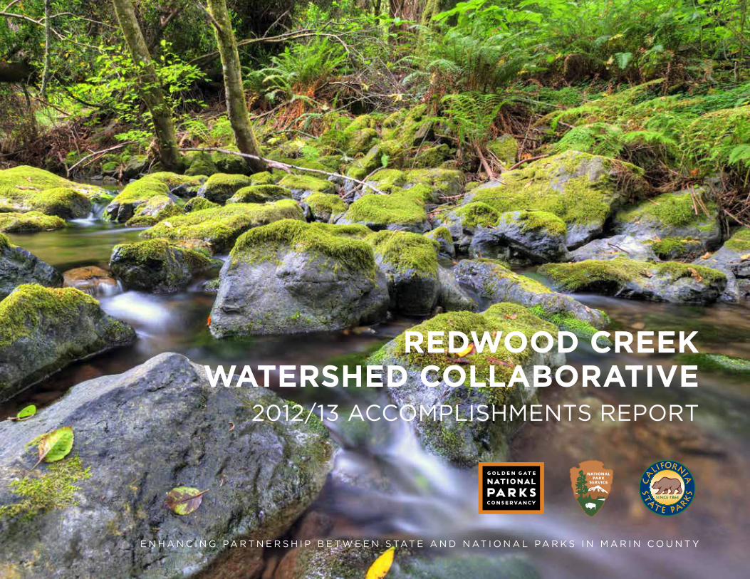
REDWOOD CREEK WATERSHED COLLABORATIVE 2012/13 ACCOMPLISHMENTS REPORT ENHANCING PARTNERSHIP BETWEEN STATE AND NATIONAL PARKS IN MARIN COUNTY
Transcript of REDWOOD CREEK WATERSHED COLLABORATIVE · REDWOOD CREEK WATERSHED COLLABORATIVE — 2012/13 ... MUIR...
REDWOOD CREEK WATERSHED COLLABORATIVE
2012/13 ACCOMPLISHMENTS REPORT
E N H A N C I N G PA R T N E R S H I P B E T W E E N S TAT E A N D N AT I O N A L PA R K S I N M A R I N C O U N T Y
REDWOOD CREEK WATERSHED COLLABORATIVE — 2012/13 ACCOMPLISHMENTS REPORT
0 1 Mile
SAN MATEO
MARIN
SONOMA
SAN FRANCISCO
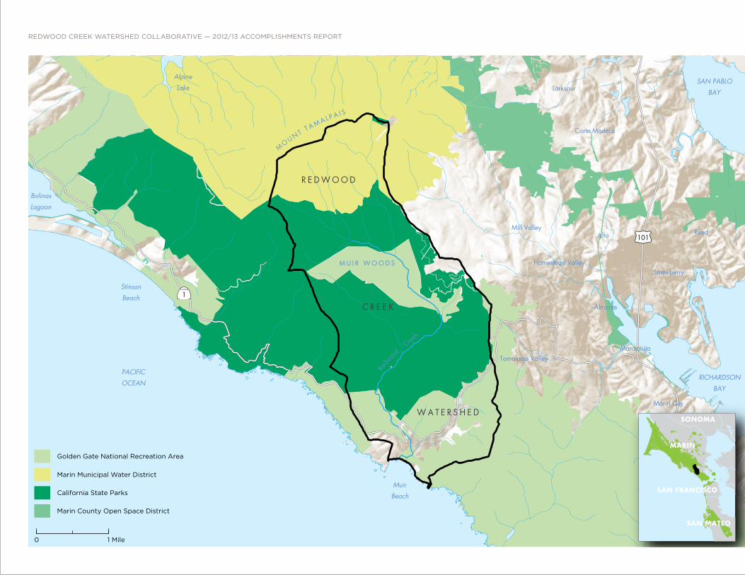
Golden Gate National Recreation Area
California State Parks
Marin County Open Space District
Marin Municipal Water District
Redw
ood
Cree
k
BolinasLagoon
RICHARDSONBAY
MuirBeach
SAN PABLOBAY
AlpineLake
MO U N T T A M A L P A I S
StinsonBeach
M U I R W O O D S
PACIFICOCEAN
101
1
Reed
Marin City
Mill Valley
Strawberry
Tamalpais Valley
Corte Madera
Larkspur
Almonte
Alto
Homestead Valley
Manzanita
R E D W O O D
W A T E R S H E D
C R E E K

1 INTRODUCTION
2 LAYING THE FOUNDATIONS FOR RESOURCE PROTECTION TOGETHER
4 PRESERVING OUR SIGNATURE TRAILS
5 THE MARIN YOUTH ECOLOGY CORPS
6 COLLABORATIVE CARE FOR OUR MAIN THOROUGHFARES
8 A UNITED FRONT AGAINST INVASIVE VEGETATION
10 EXPERIENCING THE MAGIC OF THE REDWOOD CANOPY
12 A VIEW FROM THE TOP
14 A WATERSHED APPROACH TO PUBLIC LANDS IDENTITY
16 A SAFER WAY TO THE WOODS
18 A FEEL FOR THE WATERSHED
CONTENTS
REDWOOD CREEK WATERSHED COLLABORATIVE2012/13 ACCOMPLISHMENTS REPORT
Increased entrance fees at Muir Wood contribute to the project and program support for the Collaborative.
iv REDWOOD CREEK WATERSHED COLLABORATIVE — 2012/13 ACCOMPLISHMENTS REPORT
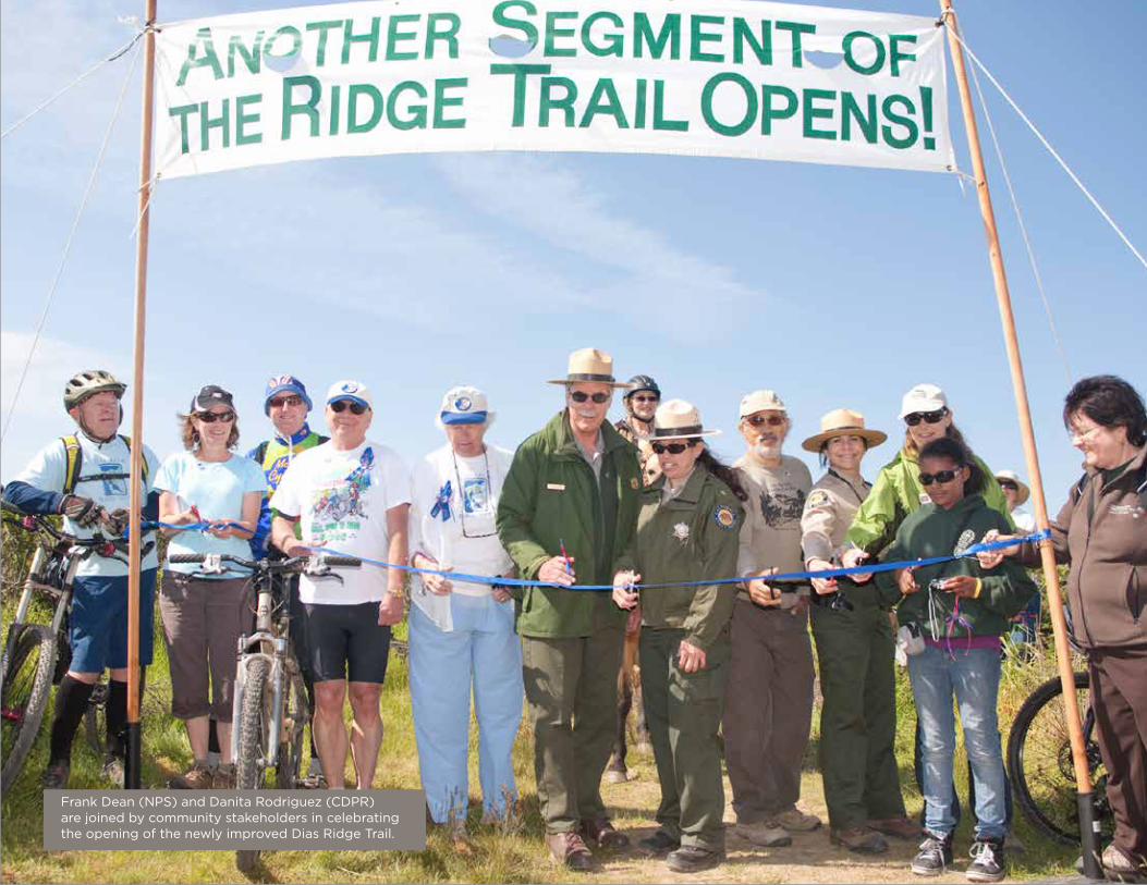
Frank Dean (NPS) and Danita Rodriguez (CDPR) are joined by community stakeholders in celebrating the opening of the newly improved Dias Ridge Trail.
One the biggest challenge was the 2011 California State Park crisis, which led to a proposal to close of four of the six state parks within Marin County. The closure of these state parks would have resulted in unacceptable risks to natural and cultural resources—and greater burdens on other land managers. The vision and partnership we had all worked so hard to establish was under a serious threat.
It has been said that a crisis is a terrible thing to waste. For parklands in Marin County, out of this crisis came a collective recommitment to our public lands and a renewed focus on a collaborative vision among land managers and non-profit partners. For the Redwood Creek Watershed, we developed an innovative partnership of the National Park Service, California State Parks, and Golden Gate National Parks Conservancy.
The National Park Service asked visitors to the most renowned destination of the watershed, Muir Woods, to contribute an additional fee for the purpose of not only keeping State Parks open, but also to realize our broader vision for the parklands. We engaged the Parks Conservancy to translate the opportunity into immediate positive results within the watershed.
Two years into this enhanced collaboration, the results have been extraordinary. Popular trails have been reopened and enhanced, encroachment from invasive plants has been stemmed, a seamless signage approach has been developed, and more than ever the National and State parks in the watershed are working as a seamless collaborative team. And there is more to come!
So much success has been realized in such a short period that we have agreed to extend this beneficial collaboration, recognizing that there is still much to do. We extend our gratitude to our staff and partners for all their hard work in making the most of this opportunity.
We also want to acknowledge the support of the community, generous donors and public agency grants in our effort to improve the Redwood Creek Watershed. We look forward to collaboration on even a greater scale as we launch the Mount Tamalpais Collaborative, adding the Marin Municipal Water District, Marin County Open Space District, and Marin County Parks to our partnership.
Although we are often faced with challenges in bringing our vision to reality, it has never been more evident that innovation and collaboration in the preservation, management, and enhancement of parks and open space is thriving in Marin County. Together, the spectacular legacy and heritage of the Redwood Creek Watershed and Mt. Tamalpais park lands we all have enjoyed can be secured for generations to come.
Sincerely,
State and National Park teams have long worked side-by-side with local communities,
agencies, and non-profits to steward the land and welcome the public to the Redwood Creek
Watershed in Marin County. In 2003, those partners, along with the Golden Gate National
Parks Conservancy, jointly created a bold vision for future conditions in the watershed and
advanced key projects such as the Dias Ridge Trail, Muir Beach Restoration, and Muir Woods
Shuttle. Still, many challenges remained.
Frank DeanGeneral SuperintendentGolden Gate National Recreation AreaNational Park Service
Danita Rodriguez SuperintendentCalifornia Department of Parks and Recreation
Greg MoorePresident and Chief Executive OfficerGolden Gate National Parks Conservancy
INTRODUCTION

2 REDWOOD CREEK WATERSHED COLLABORATIVE — 2012/13 ACCOMPLISHMENTS REPORT
LAYiNG THE FOUNDATiONS FOR RESOURCE PROTECTiON TOGETHER
Trail projects near creeks in Mount Tamalpais State Park often need separate permits from the
U.S. Army Corps of Engineers, San Francisco Regional Water Quality Control Board, and California
Department of Fish and Wildlife. Because the park is home to threatened and endangered species
such as the northern spotted owl, coho salmon, and California red-legged frog, these projects may also
require the preparation of detailed biological assessments.
For an individual agency with limited staff capacity, meeting these requirements for surveys,
assessments, permitting, and documentation can be prohibitively time-consuming and impede projects
from moving forward. Under this Collaborative, staff of the Golden Gate National Parks Conservancy
(Conservancy), National Park Service (NPS), and California Department of Parks and Recreation (State
Parks) have been able to work as a team (with consultant support) to meet all of these requirements,
and to do so in an efficient and cost-effective way.
This partnership allowed State Parks and the Conservancy to leverage natural resource and permitting expertise in both organizations to successfully complete a project with multiple benefits. – Cyndy Shafer (California State Parks/Marin Sector)

A slide in winter 2012 threat-ened to undercut a portion of the Bootjack Trail near its Rattlesnake Creek crossing. To protect the creek and preserve the trail, a rock wall needed to be installed—and the existing bridge removed and replaced—before rains in winter 2013 could cause further damage.
Equestrians who camp at Santos Meadows often use the Redwood Creek Trail to travel between Muir Woods and Muir Beach. The trail’s three bridges are pedestrian only, forcing the horses to cross through the creek channel. Currently in its planning phases, the Redwood Creek Trail Realignment Project will move the trail uphill and out of the riparian corridor, install a multi-use bridge to facilitate equestrian crossings, and improve drainage for easier trail maintenance. Before the Collaborative, a project of this scale would have been too large, complex, and expensive for any one agency to take on alone.
Case 1: Bootjack Trail
Case 2: Redwood Creek Trail
COLLABORATIVE ACHIEVEMENTS
• Allowed the State Parks to spatially
array all of their trail treatment plans,
through GIS and mapping support
from the Conservancy
• Provided consultant support for
rare-plant and special-status species
surveys, helping with this project as
well as other work in the watershed
• Advanced a trail improvement
project that will benefit the salmon,
trout, and red-legged frogs living in
Redwood Creek, and will improve
visitor access throughout the area
LAYING THE FOUNDATIONS FOR RESOURCE PROTECTION TOGETHER
2012 storm event damage resulted in closure of part of the Bootjack Trail.
A current bridge and equestrian crossing along Redwood Creek.
Mike Nelson (CDPR) guides the rock transport with a CCC member.
CCC remove the old bridge in preparation for the repair work.
The newly rebuilt bridge spans Rattlesnake Creek.

4 REDWOOD CREEK WATERSHED COLLABORATIVE — 2012/13 ACCOMPLISHMENTS REPORT
The much-used and well-loved network of trails connecting
Muir Woods and Mount Tamalpais State Park is suffering
from years of deferred maintenance. Erosion and other issues
undermine valuable trail infrastructure, threaten important
habitats, and create a less than optimal visitor experience.
Staff and funding limitations, and the cross-jurisdictional nature
of trails, have made it difficult for individual land managers to
address these issues in the past. Through this Collaborative, the
Parks Conservancy, State Parks, NPS, the Bay Area Ridge Trail
Council (BARTC), California Conservation Corps (CCC), and
Conservation Corps North Bay (CCNB) were able to work together
to efficiently address outstanding trail maintenance needs and
create comprehensive and cost-effective plans for future work.
COLLABORATIVE ACHIEVEMENTS
• Hired a project coordinator to
perform the critical functions of daily
communication and coordination with
State Parks, NPS, contractors, and
Conservancy staff
• Integrated Trails Forever interns into
the Oceanview Trail maintenance
project during the federal government
shut down of October 2013, and the
Collaborative team now works with the
Trails Forever Stewardship Program to
bring in additional volunteer groups
• Enabled the CCC, CCNB, and State
Parks to develop a deeper relationship,
identifying opportunities for future
collaborations on State Park lands
• Fostered close working relationships—
through the effective coordination of
schedules, logistics, and equipment
among the Conservancy, State Parks,
NPS, and CCNB—to complete priority
projects on the Hillside Trail, Pinchot Tree
Boardwalk and Oceanview Trail
• Developed trail treatment plans and cost
estimates for several major trails through
the efforts of State Parks trail experts
and BARTC staff (routine maintenance
projects are implementation-ready,
pending funding; a list of projects
beyond routine maintenance is ready for
compliance and permitting as a package
in 2014)
• Established well-defined needs and
thorough treatment plans, allowing for
a more proactive approach to seeking
funding for deferred maintenance
projects
PRESERviNG OUR SiGNATURE TRAiLS
Trails provide an important means for visitors to experience the natural world and deepen awareness of the grandeur and fragility of our park landscapes. Trails offer opportunities for recreation and rejuvenation, which lead us into the natural beauty and rich history of the national parks at our doorstep.– Greg Moore, President & CEO (Parks Conservancy)

The Marin Youth Ecology Corps— a youth education and job training program—focused on re-establishing fencing to keep visitors out of sensitive habitat along Redwood Creek, while offering them views of non-impacted stream side habitat. In eight weeks, the Corps installed and repaired 1,700 feet of fence, removed downed trees, repaired trail tread and drainage, re-habilitated social trails, installed signs, and fixed bridge handrails and decking.
In addition, CCNB completed critical deferred maintenance work, construct-ing over 800 square feet of retaining wall and 350 linear feet of turnpike wall, performing 1.6 miles of trio-main-tenance, installing fence, rebuilding stairs, and adding over 1,200 cubic feet of fill rock to elevate the trail tread over fragile redwood tree roots.
PRESERVING OUR SIGNATURE TRAILS
NPS trail crew and volunteers install protective fencing along a section of the Dias Ridge Trail.
Crew members carefully replace sections of split rail fencing near fern Creek.

6 REDWOOD CREEK WATERSHED COLLABORATIVE — 2012/13 ACCOMPLISHMENTS REPORT
Redwood Creek, the Deer Park Fire Road,
and Dipsea Trail weave in and out of Mount
Tamalpais State Park and Muir Woods National
Monument. High-priority maintenance needs
have remained unaddressed on these well-
worn trails for at least a decade—as a result of
a lack of funding and staff capacity. Effective
protection and management of these vital
cross-boundary resources requires the holistic
approach made possible by this Collaborative.
COLLABORATivE CARE FOR OUR MAiN THOROUGHFARES
Visitors to the watershed should not experience different trail conditions when they move between the State Park and National Park lands. This Collaborative is working to make the visitor experience consistent, with a natural flow through this singular landscape.– Frank Dean, General Superintendent (NPS)
Visitors explore the watershed through trails that are collaboratively maintained by both the National and State Parks’ staff.

COLLABORATIVE ACHIEVEMENTS
• Completed maintenance assessments,
detailed treatment plans, and cost
estimates on work that will create natural
drainage patterns and sustainable
trail alignments, reducing erosion into
adjacent springs and creeks
• Advanced this project to the compliance
stage, with hopes to be shovel-ready by
the first quarter of 2015
• Identified the need for a cooperative
maintenance strategy for all trails within
the Redwood Creek Watershed, resulting
in a more efficient and collaborative
management approach
• Formulated plans for project
implementation that will likely be highly
collaborative—drawing on the unique
skills and capacity of NPS, State Parks,
Conservancy, CCC, and CCNB staff, and
private contractors
COLLABORATIVE CARE FOR OUR MAIN THOROUGHFARES
Treatment plans include the stabilization of erosion gullies like this one found on the Deer Park Fire Road.
8 REDWOOD CREEK WATERSHED COLLABORATIVE — 2012/13 ACCOMPLISHMENTS REPORT
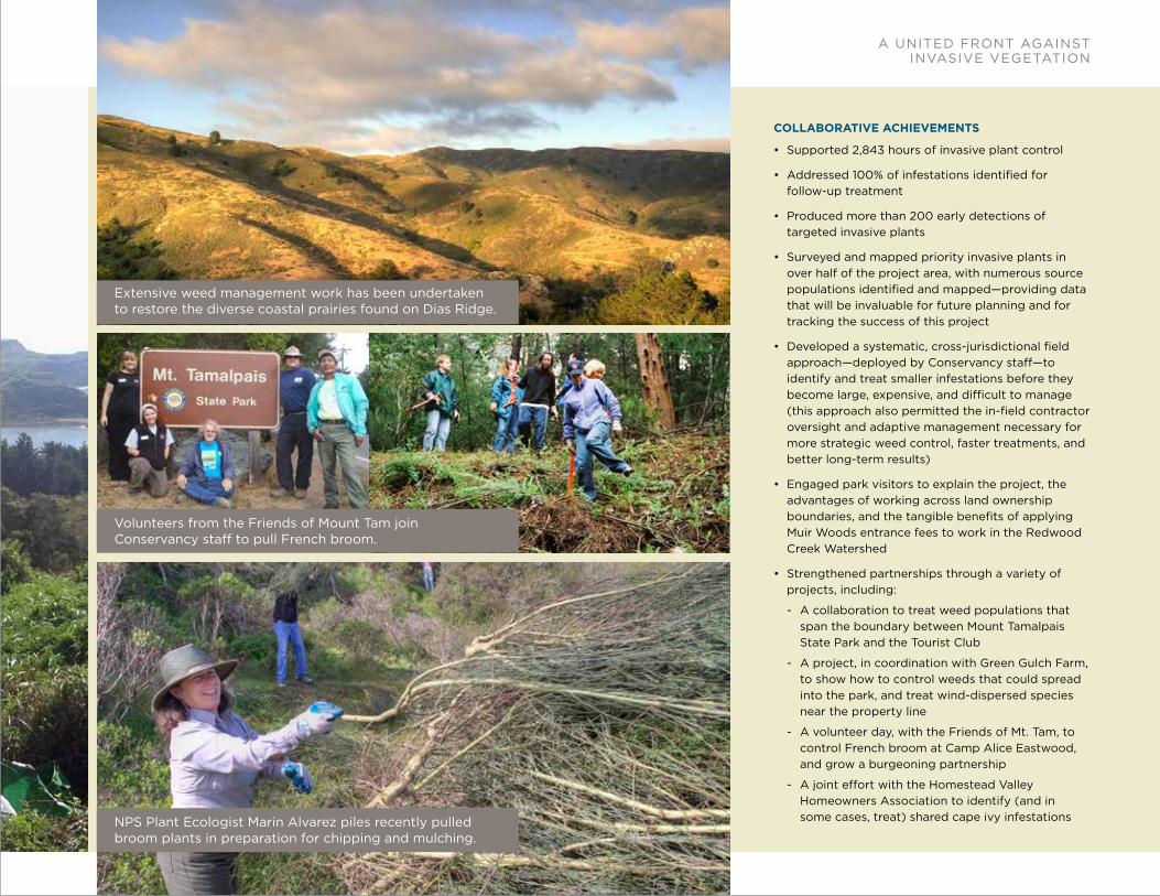
Like our trails and waterways, weeds are stubbornly unobservant of legislative
boundaries. To date, control of these invaders has been agency-based, with weed
treatments arbitrarily forced to stop at park boundaries. This restriction often left
a rich source of seed nearby to re-infest the newly cleared area. In addition to
jurisdictional barriers, effective weed control has been stymied by a shortage of
field staff and funding, and a lack of time for strategic interagency coordination.
To tackle these challenges, the collaborative Redwood Creek Invasive Plant Project
was launched in May 2013. Spanning both National Park Service and State Park
lands across the Redwood Creek Watershed, Phase 1 had three main focuses:
1) a systematic and thorough follow-up to all previously treated invasive plant
infestations in the watershed, 2) early detection and treatment of high priority
invasive plants, and 3) mapping and identification of source populations as
priorities for future control.
It is so much more efficient to work this way. We can treat a whole patch instead of having to stop half way through because we’ve moved into another park. Sometimes only one side of a patch would get treated for many years.– Contractor
Working on weeds this way really makes sense!– Park Visitor
A UNiTED FRONT AGAiNST iNvASivE vEGETATiON
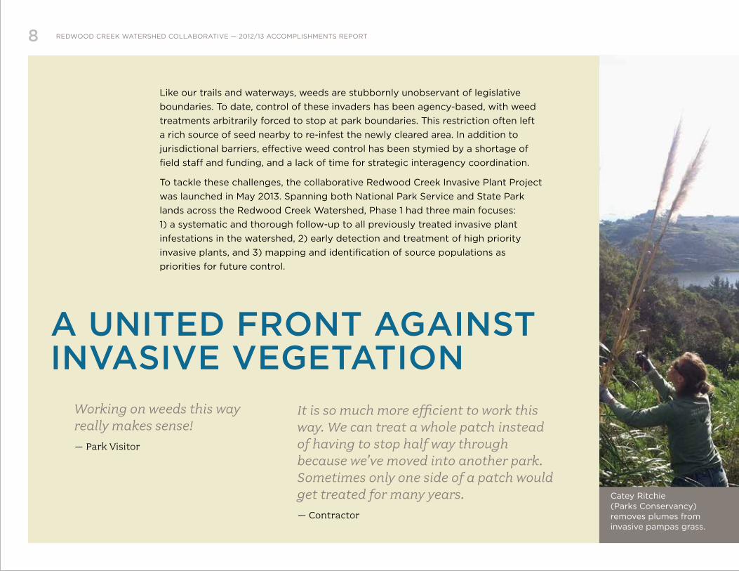
Catey Ritchie (Parks Conservancy) removes plumes from invasive pampas grass.
COLLABORATIVE ACHIEVEMENTS
• Supported 2,843 hours of invasive plant control
• Addressed 100% of infestations identified for
follow-up treatment
• Produced more than 200 early detections of
targeted invasive plants
• Surveyed and mapped priority invasive plants in
over half of the project area, with numerous source
populations identified and mapped—providing data
that will be invaluable for future planning and for
tracking the success of this project
• Developed a systematic, cross-jurisdictional field
approach—deployed by Conservancy staff—to
identify and treat smaller infestations before they
become large, expensive, and difficult to manage
(this approach also permitted the in-field contractor
oversight and adaptive management necessary for
more strategic weed control, faster treatments, and
better long-term results)
• Engaged park visitors to explain the project, the
advantages of working across land ownership
boundaries, and the tangible benefits of applying
Muir Woods entrance fees to work in the Redwood
Creek Watershed
• Strengthened partnerships through a variety of
projects, including:
- A collaboration to treat weed populations that
span the boundary between Mount Tamalpais
State Park and the Tourist Club
- A project, in coordination with Green Gulch Farm,
to show how to control weeds that could spread
into the park, and treat wind-dispersed species
near the property line
- A volunteer day, with the Friends of Mt. Tam, to
control French broom at Camp Alice Eastwood,
and grow a burgeoning partnership
- A joint effort with the Homestead Valley
Homeowners Association to identify (and in
some cases, treat) shared cape ivy infestations
A UNITED FRONT AGAINST INVASIVE VEGETATION
Extensive weed management work has been undertaken to restore the diverse coastal prairies found on Dias Ridge.
NPS Plant Ecologist Marin Alvarez piles recently pulled broom plants in preparation for chipping and mulching.
Volunteers from the Friends of Mount Tam join Conservancy staff to pull French broom.
10 REDWOOD CREEK WATERSHED COLLABORATIVE — 2012/13 ACCOMPLISHMENTS REPORT
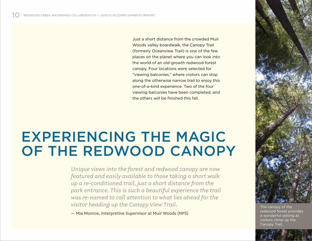
Unique views into the forest and redwood canopy are now featured and easily available to those taking a short walk up a re-conditioned trail, just a short distance from the park entrance. This is such a beautiful experience the trail was re-named to call attention to what lies ahead for the visitor heading up the Canopy View Trail.– Mia Monroe, Interpretive Supervisor at Muir Woods (NPS)
Just a short distance from the crowded Muir
Woods valley boardwalk, the Canopy Trail
(formerly Oceanview Trail) is one of the few
places on the planet where you can look into
the world of an old-growth redwood forest
canopy. Four locations were selected for
“viewing balconies,” where visitors can stop
along the otherwise narrow trail to enjoy this
one-of-a-kind experience. Two of the four
viewing balconies have been completed, and
the others will be finished this fall.
EXPERiENCiNG THE MAGiC OF THE REDWOOD CANOPY
The canopy of the redwood forest provides a wonderful setting as visitors climp up the Canopy Trail.

COLLABORATIVE ACHIEVEMENTS
• Combined the creation of the viewing
balconies (on NPS land) with over a
mile of trail work (on State Parks land),
saving time and money on both projects
through enhanced coordination
• Leveraged funding to complete viewing
balcony areas by combining the work
with trail work performed by CCNB
• Provided a working model for future
collaborations between the CCNB and
State Parks
EXPERIENCING THE MAGIC OF THE REDWOOD CANOPY
Conservation Corps North Bay crew members repair and stabilize eroding trail tread on the Canopy Trail.
A Northern Spotted Owl peers out from the Muir Woods canopy.

12 REDWOOD CREEK WATERSHED COLLABORATIVE — 2012/13 ACCOMPLISHMENTS REPORT
In early 2013, the State Parks, Conservancy, and NPS
began a collaborative effort to develop a detailed map of
the trees of Muir Woods and Kent Canyon—an invaluable
tool for trail planning, locating streams and creeks, and
tracking geomorphological changes over time.
LiDAR data developed by San Francisco State University
(SFSU) made it possible to “see” into the forest canopy
and extract information that previously had been
impossible to gather. Creating a map like this also requires
extensive fieldwork to check computer results and gather
data on the ground. In the past, jurisdictional boundaries
prevented this kind of comprehensive data collection,
and the cost, expertise, and effort required had been
prohibitive for any individual agency.
To assess tree health and make accurate crown cover measurements over large areas, the resolution and capabilities of LiDAR data make possible what current elevation datasets cannot. LiDAR data is used in many applications for analysis and visualization as well as providing vertical accuracy control for orthographic aerial imagery.– Steven Skartvedt, GIS Specialist (NPS)
A viEW FROM THE TOP

COLLABORATIVE ACHIEVEMENTS
• Created the first detailed topographic
surface and stream channel delineation
of Muir Woods and Kent Canyon, using
the data collection and management
expertise of the SFSU team, coupled with
fieldwork by Conservancy, State Parks
and NPS staff members
• Utilized the mapping data as a part of
a larger study to scout possible new
locations for a more sustainable redwood
creek crossing of the Dipsea Trail
• Made plans to create a map of tree
locations next year, using LiDAR data and
other imagery to determine tree species
• Established relationships that will
facilitate further collaborative efforts,
enabling the NPS and State Parks to
replicate this process in the future
A VIEW FROM THE TOP
Thousands of laser pulses reflect back to an airplane-mounted collector and are processed to reveal the bare earth elevations of a portion of the Redwood Creek watershed. Here can be seen traces of the old Shansky Camp road above Frank Valley at left, the switchbacks of Heather Cut-Off dropping into Santos Meadow along Muir Woods (Frank Valley) Road at bottom, and the course of Redwood Creek extending northwest upstream to Kent Canyon at upper right.

14 REDWOOD CREEK WATERSHED COLLABORATIVE — 2012/13 ACCOMPLISHMENTS REPORT
The agencies benefit through the cooperation of staff and shared resources. The natural and cultural resources and visitors benefit from the combined stewardship of the land managers and partners.– Victor Bjelajac, Maintenance Foreman (California State Parks/Marin Sector)
A WATERSHED APPROACH TO PUBLiC LANDS iDENTiTY
Effective signage not only provides the public a safer,
richer, and more enjoyable park visit, it also provides a
strong visual identity for the parklands. The Collaborative
team identified six locations for new trailhead kiosks
throughout the watershed, and developed site
improvements plans for each. New kiosk designs were
created to highlight accessible hiking routes, comply with
new accessibility requirements, and help ensure continuity
to the visitor experience throughout the watershed.
Kiosks will be installed at the following locations—Dipsea
Trail near Muir Woods, Camp Alice Eastwood, Mountain
Home Inn parking area, the East Peak, Dias Ridge, and the
Redwood Creek Trail in early 2014.
Dipsea Trail1 MILE
Ben Johnson Trail2.5 MILES
MOUNT TAMALPAIS STATE PARK
Multi-use Trail: Use Caution
New Mount Tamalpais State Park wayfinding sign

Scale: 1" = 1'-0"
P130A – Corten–Rustic Areas
88"
MUIR WOODSMUIR WOODSMUIR WOODSMUIR WOODS Corten Steel (Rustic areas)
Park NameD
A
Phenolic Resin Panel as defined by the current NPS/GGNRA Standards
Four PanelsA - Trail InformationB - Natural resource informationC - Cultural resource informationD - Other interpretive content
or glass display case for changeable information
If you encounter a mountain lion: Pick up small children and pets immediately. Remain calm - do not turn your back on the
animal or run away. Back away slowly. Stand tall, wave your arms, speak loudly or
yell, and throw sticks or rocks near (but not at) the animal.
Report any mountain lion sighting to the Muir Woods Visitor Center at (415) 388-2596.
CAUTION The climb up this trail can be long and tiring. Carry plenty of water, food, sun protection, and dress in layers. Sunny days along the coast can turn windy, foggy, and cold very fast.
Drinking water is not available along these trails.
EMERGENCY INFORMATIONCall 911or use the Yellow Call Box located along Highway 1 at Pacific Way.
UserFeeCoastal
Conservancy
Exhibit funded by this park’s
UPHILL ONLY FO R
BICYCLE
S
Shoreline Highw
ay
Muir W
oods Road
Dias Ridge Tra
il
Re
d
wood Creek
FRANK VALLEYHORSE CAMP
HAYPRESSCAMP
TO STINSON BEACH
TO M
UIR WOODS
PACIFIC OCEAN
Zen CenterGreen Gulch Farm
Ten
ne
sseeValleyTr
ail
Coastal Trail
Coastal Trail
Coast
al
Fir
e R
oa
d
Fox Trail
Coastal Fire Road
Mid
dl
e G
reen G
ulc
h T
rail
Co
yo
te
Rid
ge
Trail
Green Gulch Trail
Miwo
k T
ra
il
Miwok
T
rail Miw
ok
Redw
ood C
reek T
rail
Heather Cutoff Trail
Co
astal F
ire R
oa
d
Coastal Tr a il (Pirate
s C
o
ve)
Middle Green Gulch Trail
Chaparral Trail
T
en
ne
sse
e Valley Road
Miwo
k T
rail
Old Spring
s T
rail
Marincello Trail
County View Road
Owl Trail
Kaasi Road
Red wood
Cre
ek Tra
il
MUIRBEACH
OVERLOOK
PIRATESCOVE
MUIR BEACHCOMMUNITY TENNESSEE VALLEY
TRAILHEAD
GOLDEN GATEDAIRY
MUIRBEACH
MILL VALLEY
NATIONAL MARINESANCTUARIES
DIASRIDGE
GOLDEN GATE NATIONAL
RECREATION AREA
MOUNT TAMALPAISSTATE PARK
REDWOOD CREEK WATERSHED
Ph
oto
: Fra
nk
B
alth
is
Poison OakPoison oak can cause severe allergic reactions. Avoid touching this poisonous plant.
Wildlife EncountersMarin County has long been home to bobcats, coyotes, rattlesnakes, and an occasional mountain lion. They are important members of the natural community. However, all wildlife are unpredictable.
TicksSome tick bites can transmit Lyme disease, so inspect your clothes for ticks frequently while outdoors and again at home.
Average grade is 7%Maximum grade is 16%
Average cross slope is 5%Maximum cross slope is 7%
Average tread width is 4 feetMinimum tread width is 3 feet
The trail surface is native soil and compacted aggregate
This multi-use trail gradually climbs up coastal chapparal and grassland to a crest of 800 feet. It offers sweeping vistas of the Pacific, Mt. Tamalpais, and the Marin Headlands at every turn. On a clear day, keep an eye out for a rare sight of the Farallone Islands. Hike, bike, or horseback ride to the peak and back for a 3 mile loop. For a strenuous 6 mile trek, connect to the Miwok Trail and loop back along the Redwood Creek Trail through a riparian forest.
HikingDias Ridge Trail
200 ft
Sea Level0.5 mile 2 miles1 mile 1.5 miles 2.5 miles 3 miles
400 ft
600 ft
800 ft
20 ft
Trailhead / Panoramic HwyYou Are HereTrailhead / Golden Gate Dairy
Miwok Trail(north)
Mount Tamalpais & GGNRA Boundary
Dias Ridge Trail
Dog WalkingThe Dias Ridge Trail is closed to dogs. Dogs on leash are permitted on the Coastal Trail south from Muir Beach.
Muir Woods Visitor Center
The visitor center includes informational exhibits describing the area’s rich cultural and natural history, park-related retail, a café, and restrooms.
Visit or call for more information on Park trails and for ‘lost and found’ items.(415) 388-2596 or www.nps.gov/goga
RestroomsRestrooms are located at the Muir Beach Trailhead.
HorsesHorses are permitted on the Dias Ridge Trail and the connecting Miwok Trail.
Horses have the right-of-way over hikers and bicyclists. Equestrians should slow to a walk and stay on the trail when passing others.
BicyclingBicycles are permitted on the Dias Ridge Trail. Bikes are not permitted on the Miwok Trail north of the Dias Ridge Trail. The speed limit for bicycles is 15 mph on all trails, and 5 mph on blind curves or when passing other trail users.
Dias Ridge Trail
By the 1880s, Marin County was California's largest producer of fresh milk and butter. Much of this success was based on the hard work of recent immigrants from the Azorean islands off of Portugal. Muir Beach and Frank's Valley were then a small agricultural community. This trail is named after Silvio Dias who owned Golden Gate Dairy and the surrounding ranchlands.
MUIR WOODSMUIR WOODS MUIR WOODSMUIR WOODS
If you encounter a mountain lion: Pick up small children and pets immediately. Remain calm - do not turn your back on the
animal or run away. Back away slowly. Stand tall, wave your arms, speak loudly or
yell, and throw sticks or rocks near (but not at) the animal.
Report any mountain lion sighting to the Muir Woods Visitor Center at (415) 388-2596.
CAUTION The climb up this trail can be long and tiring. Carry plenty of water, food, sun protection, and dress in layers. Sunny days along the coast can turn windy, foggy, and cold very fast.
Drinking water is not available along these trails.
EMERGENCY INFORMATIONCall 911or use the Yellow Call Box located along Highway 1 at Pacific Way.
UserFeeCoastal
Conservancy
Exhibit funded by this park’s
UPHILL ONLY FO R
BICYCLES
Shoreline Highw
ay
Muir W
oods Road
Dias Ridge Tra
il
Re
d
wood Creek
FRANK VALLEYHORSE CAMP
HAYPRESSCAMP
TO STINSON BEACH
TO M
UIR WOODS
PACIFIC OCEAN
Zen CenterGreen Gulch Farm
Ten
ne
ssee Valley Tr
ail
Coastal Trail
Coastal Trail
Coast
al
Fir
e R
oa
d
Fox Trail
Coastal Fire Road
Mid
dl
e G
reen G
ulc
h T
rail
Co
yo
te
Rid
ge T
rail
Green Gulch Trail
Miwo
k T
ra
il
Miwok T
rail Miw
ok
Redw
ood C
reek T
rail
Heather Cutoff Trail
Co
astal F
ire R
oa
d
Coastal Tr ail (Pirate
s Co
ve)
Middle Green Gulch Trail
Chaparral Trail
T
en
ne
sse
e Valley Road
Miwo
k T
rail
Old Spring
s Trail
Marincello Trail
County View Road
Owl Trail
Kaasi Road
Red wood
Cre
ek Tra
il
MUIRBEACH
OVERLOOK
PIRATESCOVE
MUIR BEACHCOMMUNITY TENNESSEE VALLEY
TRAILHEAD
GOLDEN GATEDAIRY
MUIRBEACH
MILL VALLEY
NATIONAL MARINESANCTUARIES
DIASRIDGE
GOLDEN GATE NATIONAL
RECREATION AREA
MOUNT TAMALPAISSTATE PARK
REDWOOD CREEK WATERSHED
Ph
oto
: Fra
nk
Ba
lth
is
Poison OakPoison oak can cause severe allergic reactions. Avoid touching this poisonous plant.
Wildlife EncountersMarin County has long been home to bobcats, coyotes, rattlesnakes, and an occasional mountain lion. They are important members of the natural community. However, all wildlife are unpredictable.
TicksSome tick bites can transmit Lyme disease, so inspect your clothes for ticks frequently while outdoors and again at home.
Average grade is 7%Maximum grade is 16%
Average cross slope is 5%Maximum cross slope is 7%
Average tread width is 4 feetMinimum tread width is 3 feet
The trail surface is native soil and compacted aggregate
This multi-use trail gradually climbs up coastal chapparal and grassland to a crest of 800 feet. It offers sweeping vistas of the Pacific, Mt. Tamalpais, and the Marin Headlands at every turn. On a clear day, keep an eye out for a rare sight of the Farallone Islands. Hike, bike, or horseback ride to the peak and back for a 3 mile loop. For a strenuous 6 mile trek, connect to the Miwok Trail and loop back along the Redwood Creek Trail through a riparian forest.
HikingDias Ridge Trail
200 ft
Sea Level0.5 mile 2 miles1 mile 1.5 miles 2.5 miles 3 miles
400 ft
600 ft
800 ft
20 ft
Trailhead / Panoramic HwyYou Are HereTrailhead / Golden Gate Dairy
Miwok Trail(north)
Mount Tamalpais & GGNRA Boundary
Dias Ridge Trail
Dog WalkingThe Dias Ridge Trail is closed to dogs. Dogs on leash are permitted on the Coastal Trail south from Muir Beach.
Muir Woods Visitor Center
The visitor center includes informational exhibits describing the area’s rich cultural and natural history, park-related retail, a café, and restrooms.
Visit or call for more information on Park trails and for ‘lost and found’ items.(415) 388-2596 or www.nps.gov/goga
RestroomsRestrooms are located at the Muir Beach Trailhead.
HorsesHorses are permitted on the Dias Ridge Trail and the connecting Miwok Trail.
Horses have the right-of-way over hikers and bicyclists. Equestrians should slow to a walk and stay on the trail when passing others.
BicyclingBicycles are permitted on the Dias Ridge Trail. Bikes are not permitted on the Miwok Trail north of the Dias Ridge Trail. The speed limit for bicycles is 15 mph on all trails, and 5 mph on blind curves or when passing other trail users.
Dias Ridge Trail
By the 1880s, Marin County was California's largest producer of fresh milk and butter. Much of this success was based on the hard work of recent immigrants from the Azorean islands off of Portugal. Muir Beach and Frank's Valley were then a small agricultural community. This trail is named after Silvio Dias who owned Golden Gate Dairy and the surrounding ranchlands.
COLLABORATIVE ACHIEVEMENTS
• Infused signage with richer and more
watershed-based interpretive content
and maps, by combining the expertise of
the NPS, State Parks and Conservancy
• Established a collaborative kiosk sign
design, in parallel with updating the
interpretive sign design for the Golden
Gate National Parks
• Facilitated the adoption of Golden Gate
National Parks Signage and Graphic
Guidelines by the State Parks for the
Redwood Creek Watershed, with a
slight modification of the color palette
to distinguish signs on State Park lands
from those on NPS lands
• Completed a comprehensive signage
inventory, building off the existing State
Parks work
• Continued developing a watershed-
wide wayfinding sign plan, with
implementation scheduled for early 2014
• Installed a Muir Beach kiosk, with
fabrication and installation of the
remaining kiosks planned for early 2014
A WATERSHED APPROACH TO PUBLIC LANDS IDENTITY
After
Before
Trailhead Exhibit featuring natural and cultural resource interpretation as well as trail information including maps and featured accessible hikes.

16 REDWOOD CREEK WATERSHED COLLABORATIVE — 2012/13 ACCOMPLISHMENTS REPORT
Throngs of Muir Woods visitors park along the narrow and winding
road leading into the National Monument, creating a dangerous
situation for pedestrians, bicyclists, and vehicular traffic. They
also leave a significant amount of trash along the shoulder, which
affects the health of nearby Redwood Creek.
In the past, a lack of staff capacity forced NPS and State Parks
to address these issues reactively, such as through emergency
responses to accidents and the issuance of citations to
cars blocking the road. Additional funding provided by the
Collaborative has allowed the State Parks to hire the equivalent of
two full-time seasonal maintenance aides to address these issues in
a more positive and proactive way—creating a much safer and less
frustrating experience for park visitors.
Without collaboration of State Parks, NPS, and Marin county staff, impacts to the Redwood Creek Watershed would continue to compound. The team approach has allowed for management solutions to be developed in order to protect the cultural and natural resources in the area—and increase visitor safety and enjoyment of the lands that we all manage.– Victor Bjelajac, Maintenance Foreman (California State Parks/Marin Sector)
A SAFER WAY TO THE WOODS

COLLABORATIVE ACHIEVEMENTS
• Supported maintenance aides who help visitors find
safe parking and ways to get into the monument,
provide directions and information about the park and
the Redwood Creek Watershed, pick up trash along
Muir Woods Road and in parking lots, and maintain
vegetation along the roadway and trails
• Decreased the number of emergency calls (according
to park and county law enforcement officials),
alleviated congestion on emergency response travel
routes, and reduced emergency response costs
• Observed less trash in and along Redwood Creek, as
visitors are made aware of the national and state park
lands and informed about watershed ecology
• Established monthly coordination meetings among
staff of the NPS, State Parks, and Marin County
Department of Public Works to collaborate, exchange
planning information, and work towards their common
goals throughout the county
A SAFER WAY TO THE WOODS
Seasonal Ranger August Aubrey helps guide visitor parking and ensures resources are protected along Muir Woods Road.
18 REDWOOD CREEK WATERSHED COLLABORATIVE — 2012/13 ACCOMPLISHMENTS REPORT
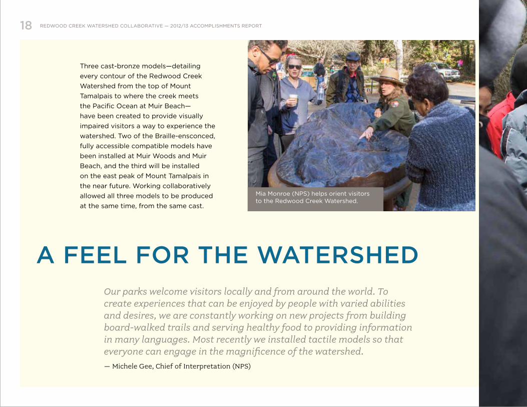
Three cast-bronze models—detailing
every contour of the Redwood Creek
Watershed from the top of Mount
Tamalpais to where the creek meets
the Pacific Ocean at Muir Beach—
have been created to provide visually
impaired visitors a way to experience the
watershed. Two of the Braille-ensconced,
fully accessible compatible models have
been installed at Muir Woods and Muir
Beach, and the third will be installed
on the east peak of Mount Tamalpais in
the near future. Working collaboratively
allowed all three models to be produced
at the same time, from the same cast.
A FEEL FOR THE WATERSHEDOur parks welcome visitors locally and from around the world. To create experiences that can be enjoyed by people with varied abilities and desires, we are constantly working on new projects from building board-walked trails and serving healthy food to providing information in many languages. Most recently we installed tactile models so that everyone can engage in the magnificence of the watershed. – Michele Gee, Chief of Interpretation (NPS)
Mia Monroe (NPS) helps orient visitors to the Redwood Creek Watershed.

David Pon (Parks Conservancy) explores the watershed model with local youth.

E N H A N C I N G PA R T N E R S H I P B E T W E E N S TAT E A N D N AT I O N A L PA R K S I N M A R I N C O U N T Y
Redwood Creek Watershed Collaborativeparksconservancy.orgnps.gov/gogaparks.ca.gov