REDISCOVERING GAUR : A MEDIEVAL CAPITAL OF · PDF fileArchaeological Survey of India in 1879,...
39
Journal of the Asiatic Society of Bangladesh (Hum.), Vol. 58(1), 2013, pp. 27-65 REDISCOVERING GAUR : A MEDIEVAL CAPITAL OF BENGAL * Sutapa Sinha ** The paper attempts to reconstruct the archaeological re-discovery of the capital city of Sultanate Bengal, popularly known as Gaur during mediaeval time. The account and reason of the decline of this once populous and glorious city, its abandonment and eventual desertion in the 16 th century have been dealt with by several scholars and hence kept beyond the purview of this lecture. It is also well known that the rich architectural heritage of the desolate city was systematically stripped off for building material for more than two centuries sparing only the religious edifices. It was Henry Creighton, an indigo planter stationed at Guamalty Indigo Factory near Malda who pioneered the work of re-discovering the lost city of Gaur in the last quarter of the 18 th century. The ruins of the city was then fully covered with dense jungle and in Creighton’s own words “shelter a variety of wild creatures, bears, buffaloes, deer, wild hogs, snakes, monkies, peacocks, and the common domestic fowl, rendered wild for want of an owner. At night the roar of the tiger, the cry of peacock, the howl of the jackals, with the accompaniment of rats, owls, and troublesome insects, soon become familiar to the few inhabitants still in its neighbourhood”. 1 In spite of these hindrances, Creighton prepared the first topographical map of the fortified city and its suburbs showing contours of the huge rampart walls as accurately as possible. He also drew a separate sketch of the royal fort or the Citadel of the Sultan. Creighton was an excellent amateur painter. In course of his archaeological enquiry in the * This was Maulavi Shamsuddin Ahmed Memorial Trust Fund Lecture 2012 at the Asiatic Society of Bangladesh, Dhaka. ** Associate Professor and Head, Department of Islamic History and Culture, University of Calcutta, Kolkata. 1 Henry Creighton, The Ruins of Gaur: Described and Represented in eighteen view with a topographical map, London 1817, pp. 4-5.
Transcript of REDISCOVERING GAUR : A MEDIEVAL CAPITAL OF · PDF fileArchaeological Survey of India in 1879,...
Journal of the Asiatic Society of Bangladesh (Hum.), Vol. 58(1), 2013, pp. 27-65
REDISCOVERING GAUR : A MEDIEVAL CAPITAL OF BENGAL*
Sutapa Sinha**
The paper attempts to reconstruct the archaeological re-discovery of the capital city of Sultanate Bengal, popularly known as Gaur during mediaeval time. The account and reason of the decline of this once populous and glorious city, its abandonment and eventual desertion in the 16th century have been dealt with by several scholars and hence kept beyond the purview of this lecture. It is also well known that the rich architectural heritage of the desolate city was systematically stripped off for building material for more than two centuries sparing only the religious edifices.
It was Henry Creighton, an indigo planter stationed at Guamalty Indigo Factory near Malda who pioneered the work of re-discovering the lost city of Gaur in the last quarter of the 18th century. The ruins of the city was then fully covered with dense jungle and in Creighton’s own words “shelter a variety of wild creatures, bears, buffaloes, deer, wild hogs, snakes, monkies, peacocks, and the common domestic fowl, rendered wild for want of an owner. At night the roar of the tiger, the cry of peacock, the howl of the jackals, with the accompaniment of rats, owls, and troublesome insects, soon become familiar to the few inhabitants still in its neighbourhood”.1 In spite of these hindrances, Creighton prepared the first topographical map of the fortified city and its suburbs showing contours of the huge rampart walls as accurately as possible. He also drew a separate sketch of the royal fort or the Citadel of the Sultan. Creighton was an excellent amateur painter. In course of his archaeological enquiry in the
* This was Maulavi Shamsuddin Ahmed Memorial Trust Fund Lecture 2012 at the Asiatic
Society of Bangladesh, Dhaka. ** Associate Professor and Head, Department of Islamic History and Culture,
University of Calcutta, Kolkata. 1 Henry Creighton, The Ruins of Gaur: Described and Represented in eighteen view with
a topographical map, London 1817, pp. 4-5.
28 Sutapa Sinha
ruins of Gaur he made sketches of the extant monuments and ruins. He collected detached inscriptions from the deep jungles and preserved them in the courtyard of his factory. His untimely death in 1807 put to an end to the first initiative to rediscover history and archaeology the lost city of Gaur. However, in 1817, the result of his exertions at Gaur was published posthumously in the form of a book2 with eighteen drawings and a map compiled from his manuscripts and drawings. Through the eighteen views rendered in brilliant water colour, Creighton made the first attempt to capture the extant monuments and ruins of the lost city. Creighton’s seminal work was followed and mentioned by the few European Officials visiting Gaur during the 19th century. They have also left descriptions of the city, its monuments and inscriptions supplemented by drawings, etchings, prints, photographs and also valuable maps and sketches. Notable among them are William Francklin,3 Francis Buchannan,4 J.H. Ravenshaw5 and J.D. Beglar.6
In this context it may be mentioned that it was till the time of J.H. Ravenshaw and J.D. Beglar, i.e. in the sixties and seventies of the 19th century, the ruins of Gaur was still in a “very jungly state and several of the ruins could only be approached with difficulty, owing to the dense canebreaks which were too green to burn, and too thickly covered with long sharp thorns to be forced by the elephants.”7 When General Alexander Cunningham first visited Gaur in 1840s, forty years prior to his visit as the Director General of the Archaeological Survey of India in 1879, he saw a long piece of skeleton of a python measuring nearly 9 inch in diameter amidst the deep jungles. Things radically changed when, in the cold season of 1879, Cunningham as the Director General of ASI made his official visit to Gaur. He states in his report that,
2 Ibid. 3 William Francklin, Journal of a route from Rajemehal to Gaur A.D. 1810-11, Shillong,
1910. 4 Francis Buchanan Hamilton, Geographical, Statistical and Historical Descriptions of the
District, or Zila of Dinajpur, Calcutta 1833. 5 J.H. Ravenshaw, Gaur: its Ruins and Inscritptions, London 1878. 6 J.D. Beglar, Report of the Archaeological Survey of Bengal, Parts I & II. Calcutta,
Catholic Orphan Press 1888. 7 Alexander Cunningham, Report of a Tour in Bengal and Bihar in 1879-80. From Patna
to Sunargaon. Vol. XV, New Delhi 2000 (reprint), p. 48.

Rediscovering Gaur 29
… the whole scene was changed, the greater part of the jungle had been cleared away, and all the lowlands above the water-level were covered with crops and of urad and sarsan [veches and mustard.] The mounds are still covered with jungle, as they are mostly composed of brick ruins which are not worth cultivating. The cause of all this change is due to the Government having offered lands almost rent-free at the low price of 4 annas a bigah for a fixed period. The offer was eagerly taken up by the people, and nearly the whole of the available land is now under cultivation.8
This changed scene of the ruins of Gaur is interesting from two different aspects. Firstly, the clearance of dense jungles over the ruins facilitated the exploratory tour of Cunningham which could be considered as the first archaeological exploration of the city of Gaur and its suburbs in a systematic manner. Resultant report provided by him is invaluable to the future researcher. Secondly, at the same time this clearing activity exposed the sub-soil structures to ruination through plough-sharing for cultivation and brick hunting, the latter is practiced even in the present day, resulting in gradual decay of the ‘ habitation sites’. It may not be out of context at this point if we mention that it is the policy of the Government or the ruling authority that has always played an important role to determine the fate of the city in its hey days and also in its ruinous state. Because it is already recorded that ‘in the rainy season, boat could easily reach the ruins and of boatloads of stones and bricks were removed to the then rising towns of English Bazar, Murshidabad, Rajmahal and Calcutta’. According to Grant’s report9 (Vol. V, p. 285), ‘the Nizamat Daftar of Murshidabad received Rs. 8000 annually from the local Zamindars as fees for the privilege of demolishing the ruins and stripping from them their highly prized enameled bricks and basalt stones’. Abid Ali mentions that “we are fortunate to find remains of certain mosques and the tombs of saints which the plunderers did not touch on account of their being sacred”.10 Few secular edifices survived in the capital city before Government implemented rules to stop this practice of demolition of the ruined edifices in 1899.
In the beginning of the 20th century, a Government official, who was in charge of the work of repairing the ruins of Gaur and Pandua and hailed from Malda
8 Op. cit, p. 48. 9 Walter Kelly Firminger (ed.), Affairs of the East India Company, (being the Fifth Report
from the Select Committee of the House of Commons 28th July, 1812), Vol. II, Delhi (Reprint), 2001, pp. 220-221.
10 Khan Sahib M. Abid Ali Khan, Memoirs of Gaur and Pandua: Edited and revised by H.E. Stapleton (reprint and revised) Calcutta 1986, p. 31.

30 Sutapa Sinha
district thought of publishing a book which would encompass all the desirable information on the subject of the ruins, the history and the principal features of the ruins as they extant’. He was none other than Khan Shahib Abid Ali Khan who tried to make it ‘useful to the archaeologist, to distinguished visitors and to the public at large’.11 He presented the first draft of his book in a hastily prepared type-written form to Lord Curzon while he was visiting Gaur and Pandua in 1902 which was later published as Memoirs of Gaur and Pandua in 1912 in a booklet form. Later in 1930, H.E. Stapleton published it after much revision12 on the request of the Government as it contains much important information regarding the monuments, inscriptions and local legends of the ruined city.
The Archaeological Survey of India also started to pay attention towards the conservation of the monuments of the ruined city of Gaur and Pandua, which were visited, perhaps twice, by its Director General since 1879. From a study of the Annual Reports of Archaeological Survey of India published since 1902, we find mention of first conservation work at Adina Masjid, Eklakhi Mausoleum and Qutb Shahi Masjid at Pandua in 1902-03.13 In the same year conservation works at the important monuments of Gaur (undivided) like Baradwari or Great Golden Mosque, Sona Masjid or Small Golden Mosque (Firozpur), Dakhil Darwaza, Firoz Minar, Tantipara Mosque and Lattan Mosque also were undertaken. In 1905-06, a sum of Rs. 7,165 was expended for conservation work at Sona Masjid of Firozpur.14 Again in 1916, we find mention of conservation works at Adina Masjid in Pandua as a part of annual conservation programme in Eastern India.15 In 1924-25, repairing work at Darasbari Mosque and Baisgazi wall has been done along with erection of notice board ‘to twelve monuments at Gaur’ for protection purpose. It also states that a sum of Rs. 1000 was provided in the budget for the excavation proposal of some underground chambers near the Gumti gate could not be utilized because the land could not be purchased in time.16 This is the first 11 Ibid, preface, p. x. 12 Ibid, with an introductory note by Dr. A. Ray and Dr. C. Datta published in 1986 by the
Department of Information & Cultural Affairs, Government of West Bengal. 13 Archaeological Survey of India. Annual Reprot, 1902-03, New Delhi (reprint) pp. 52-53
(hereinafter referred as ASIAR). 14 ASIAR, 1905-06, p. 8. 15 ASIAR, 1916-17, Part-I, p. 9. 16 ASIAR, 1924-25, p. 37.

Rediscovering Gaur 31
mention of a proposal for excavation work at Gaur in the reports of Archaeological Survey of India. Subsequently, in the annual report of 1927-28, we find that ‘the clearance of the area between the Chika Mosque and Gumti gateway has disclosed the existence of a floor of painted tiles and a mosque with half-damaged stone pillars. It further stated that this area was examined with a view to determine the nature of the underground stone cells visible at a short distance to the east. As the digging proceeded it was clear that there were at least three cells, most probably intended to be used as graves, almost 4 feet deep with a terraced floor and walls of dressed stone. Their openings being closed by rough-hewn slabs of stone placed breadth wise. As traces of inhumation were discovered in two of the graves, the work was stopped immediately’.17 Therefore, this small scale digging operation conducted by ASI further supported that General Cunningham was right in identifying Chika as a mausoleum and its adjacent areas as cemetery for the later Ilyas Shahi Sultans and their family.
Aside this small digging, no full scale archaeological excavation or exploration work was undertaken by the ASI in addition to their routine work of conservation and preservation of the monuments of Gaur before the partition of 1947. It is surprising to note that no other proposal for excavation or exploration was mooted at any level to uncover the layout of this capital city in a large scale, or a small scale excavation to reveal the cultural assemblage and cultural sequence of this medieval city. After 1947, as a result of the partition, the entire southern suburb of Gaur was included in the sovereign state of Pakistan. From 1950s onwards, conservation of the monuments in the Indian part of Gaur (in Indian Archaeology: A Review series) was continued. But no archaeological exploration and excavation in the city was conducted in the immediate post-independence era under the aegis of ASI.
However, in the post-independence period also, conservation and restoration work of the monuments of Gaur was going on at regular interval and reports of which have been published till recent past and thus protected monuments of the city are being preserved for the posterity. But at the same time the open areas like the palace proper (inside Bais Gazi walls) or any other parts of the city with buried structures were exposed to brick hunting and cart-loads of bricks were
17 ASIAR, 1927-28, pp. 42-3.

32 Sutapa Sinha
being smuggled by the villagers for re-use, not only in the adjacent villages but also sometimes in Malda town. No Government agency, neither State nor Central could put a stop to this practice.
It should be mentioned here that some important works have been done in the Bangladesh part of Gaur after independence. Firstly: the full scale excavation conducted by the Department of Archaeology, Bangladesh in 1970s which unearthed the most important learning centre, i.e Darasbari Madrasah adjacent to Darasbari Mosqe in the southern suburb of Gaur. The report of this excavation has been published by the Asiatic Society of Bangladesh.18 The exploratory survey conducted in the Bangladesh part of the city of Gaur i.e. the southern suburb of the city called Firuzpur resulted in a monograph entitled Gawr-Lakhnawati and was also published by the Asiatic Society of Bangladesh.19 The Directorate of Archaeology, Bangladesh conducted a survey of the Choto Sona Masjid and its adjacent area in 2001 and considering their importance undertook a project in 2003-05 in order to conserve and preserve all archaeological edifices and sites in this area. A beautifully designed tiled floor was discovered in front of the Mosque through an excavation under the leadership of Dr. Mohd. Shafiqul Alam, the then Director of Archaeology, Bangladesh.20
Thus, in spite of all these serious endeavors, both private and public, since last quarter of the 18th century, we are hopelessly unaware about the morphology of the city of Gaur. Only the location of the Royal Centre of the city, a very prominent site, heavily protected by massive citadel wall with a deep moat surrounding it could easily be identifiable. Remaining parts of the city were never explored barring the ruins of religious monuments, gateways, a minar (victory tower) and a bridge of five arches without situating them within the urban landscape of the city.
18 Muhammad Abdul Qadir, "The Newly Discovered Madrasah Ruins at Gaur and its
inscriptions", Journal of the Asiatic Society of Bangladesh (Humanities), Vol's. xxiv-vi , Dacca, 1979-81, pp. 21-90.
19 A.B.M. Husain (ed.), Gawr-Lakhnawti: A Survey of Historical Monuments and Sites in Bangladesh, Asiatic Society of Bangladesh, Dhaka 1997.
20 Dr. Mohd. Shafiqul Alam and Abdul Khaleq, “Chakchake Prolepjukta Talir Mejhe: Choto Sona Masjide Samprotik Abishkar” (in Bangali) in Pratnacharcha -2, a Journal of Directorate of Archaeology, Bangladesh, No. 2, 2nd Year, March, 2008, pp. 71-74.
Rediscovering Gaur 33
II
With the above-mentioned problem in view, the Directorate of Archaeology, West Bengal undertook a research project on Urbanization of two capital cities of medieval Bengal, i.e Gaur and Pandua in collaboration with Department of Islamic History and Culture, University of Calcutta in 1992. In the following pages, an attempt will be made to enumerate, in brief the outcome of the exploratory work which officially continued for five years to reconstruct the lost city. Later in this discourse, I would also like to mention about the report of a full-scale excavation at the Palace compartments of the Fort and two scientific clearance works at the sites of Husain Shah’s tomb and Belbari Madrasah of Gaur which were undertaken in the field seasons of 2003-2005 by Archaeological Survey of India.
The methodology adopted for achieving the above-mentioned objective of the research project on urbanization of the medieval city of Gaur undertaken in 1992 was threefold: 1. To built up a comprehensive database of all the published and unpublished
records including coins, inscriptions, historical manuscripts, visual materials, maps and other related documents on these cities.
2. To carry out sector-wise archaeological explorations in these cities to situate habitation pattern and to collect evidence of material culture.
3. To collate the available records with the archaeological findings and analyse the same in the historical perspective to locate inter alia, the causes of growth and decline of the city.
To locate the habitation zones in this large stretch of walled city, the Project team21 had first taken recourse to archaeological reconnaissance of the entire area to identify the typical archaeological assemblage of the period. The random survey conducted throughout the medieval city by the team was able to record the artefact assemblage representative of the period. They can be categorized as follows: 1. Coarse pottery: both intact and in sherds, of grey, black and brown slips of
various shapes and sizes - flat dishes, bowls, lamps, spouted vessels, bottle necked miniature vessels and storage jars; (Fig.1)
21 The team comprising Dr. Gautam Sengupta, Pratip Kumar Mitra and Sutapa Sinha
representing the Directorate of Archaeology and Museums, West Bengal and Professors Aniruddha Ray, Muhamad Qamaruddin and Ratnabali Chatterjee representing the Department of Islamic History & Culture, University of Calcutta.
34 Sutapa Sinha
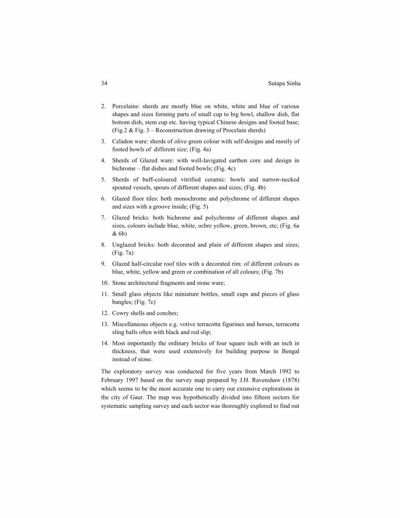
2. Porcelains: sherds are mostly blue on white, white and blue of various shapes and sizes forming parts of small cup to big bowl, shallow dish, flat bottom dish, stem cup etc. having typical Chinese designs and footed base; (Fig.2 & Fig. 3 – Reconstruction drawing of Procelain sherds)
3. Celadon ware: sherds of olive green colour with self-designs and mostly of footed bowls of different size; (Fig. 4a)
4. Sherds of Glazed ware: with well-lavigated earthen core and design in bichrome – flat dishes and footed bowls; (Fig. 4c)
5. Sherds of buff-coloured vitrified ceramic: bowls and narrow-necked spouted vessels, spouts of different shapes and sizes; (Fig. 4b)
6. Glazed floor tiles: both monochrome and polychrome of different shapes and sizes with a groove inside; (Fig. 5)
7. Glazed bricks: both bichrome and polychrome of different shapes and sizes, colours include blue, white, ochre yellow, green, brown, etc; (Fig. 6a & 6b)
8. Unglazed bricks: both decorated and plain of different shapes and sizes; (Fig. 7a)
9. Glazed half-circular roof tiles with a decorated rim: of different colours as blue, white, yellow and green or combination of all colours; (Fig. 7b)
10. Stone architectural fragments and stone ware;
11. Small glass objects like miniature bottles, small cups and pieces of glass bangles; (Fig. 7c)
12. Cowry shells and conches;
13. Miscellaneous objects e.g. votive terracotta figurines and horses, terracotta sling balls often with black and red slip;
14. Most importantly the ordinary bricks of four square inch with an inch in thickness, that were used extensively for building purpose in Bengal instead of stone.
The exploratory survey was conducted for five years from March 1992 to February 1997 based on the survey map prepared by J.H. Ravenshaw (1878) which seems to be the most accurate one to carry out extensive explorations in the city of Gaur. The map was hypothetically divided into fifteen sectors for systematic sampling survey and each sector was thoroughly explored to find out
Rediscovering Gaur 35
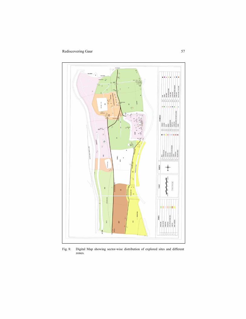
distinct spatial clustering of artefacts, features, structures and environmental remains. Such clusters denoting habitation sites were plotted in the respective sector maps and altogether 113 such sites have been identified by the team. Along with that, all the extant structures – religious and secular, embankments, canals, roadways – either metalled or unmetalled, and other architectural remains related to habitation have also been plotted in the sector maps as much as possible. After reassembling all these fifteen sector maps embodying all these sites and other related features, a schematic representation of the settlement pattern of the city have been formed on the basis of spatial distribution and density of the assemblages in the different parts of the city and their interrelation with extant structures.22 (Fig. 8) The capital city of Gaur may now broadly be divided into four principal zones namely the Royal Centre, the Noble’s Quarter, the Urban Core and the Garrison Area. Another auxiliary zone may also be defined from the reassembled map which we have termed as Fringe Area. People from secondary occupation may have lived here. The remaining north and north-eastern extremity of the fortified city is a low-lying tract like a shallow basin. It is now a cultivated land for rice and probably was used for cultivation of emergency crop when the city was besieged and thus may be termed as buffer zone of the city.
The most important functional zone is the Royal Centre, the nucleus of the city situated on the south-western side of the city overlooking the river on its west. The Royal Centre, Sector 5 in the base map is the citadel including the Palace. The imposing citadel occupies the most prominent and advantageous position in the city and is situated on the highest ground on the eastern bank of the Bhagirathi. Some 48 habitation sites have been located in the entire citadel area through surface survey and a considerable variation in type, quantity and quality of the artifacts scatter in these sites has been observed and plotted in the map of Sector 5. (Fig. 9)
On the north of the citadel was the main entrance - called Dakhil or Salami Darwaza. One could visualize a straight approach from this gate to the palace proper through a raised paved road. We have found ruins of two intermediary gateways on this royal road, traditionally known as Chand Darwaza and Nim
22 See, Sutapa Sinha, “Settlement Pattern through Archaeological Finds”, in Gaur The
Medieval City of Bengal c. 1450-1565, special issue of a Journal of Archaeology Pratna Samiksha, New Series, Vol. 3, Kolkata 2012, pp. 127-137.
36 Sutapa Sinha
Darwaza, the latter meaning the midway gate and found mentioned in the works of Henry Creighton. During the survey, we have found the ruins of the gate, which is placed exactly at the mid distance on the road connecting Dakhil Darwaza and Royal palace. However, the inscription referring to a mid-way gate exquisitely carved is now affixed to the Minaronwali Mosque in the village of Mahadipur, P.S. English Bazar, west of the ruins of the city of Gaur (Fig. 10).
Exploration in this area, however, failed to trace any evidence of nine intermediary gates as mentioned in a contemporary Portuguese account.23 Instead, some small ruined structures were found along the road, which could probably be the guardrooms.
23 G. Bouchon and L.P. Thomaz (ed.), Voyage Dans Les Deltas Du Gange et de
L'irraouaddy 1521, Paris 1988 (English version), p. 321.

Rediscovering Gaur 37
The Palace proper was a rectangular area and was enclosed on three sides by a high brick wall measuring 42 feet high excepting the western side. The wall is popularly known as Baisgazi wall i.e. a wall measuring 22 yards or 66 feet. The enclosed area of the Palace measures approximately 300 meters × 100 meters and is divided into three unequal compartments. The first and the northern compartment of the Palace was the Durbar hall or the Court of the Sultan. The second was presumed to be the living apartment of the Sultan while the third one was traditionally known as the Haremsara or the living quarter of the women in the Palace. Each compartment having a tank within it was separated by a dividing wall, remnants of which can only be traced in the underground, somewhere only traces of hollow tunnels are visible after brick robbing from the foundation of the wall.
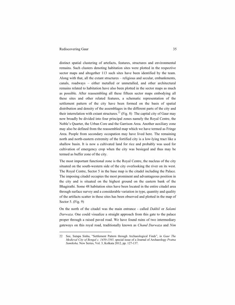
From the nine sites of the first compartment (so called Durbar hall) plenty of architectural fragments of stone as well as decorated bricks (18.06%), glazed bricks (16.12%), floor tiles (9.68%) and glazed pipes (12.90%) have been found along with remains of a white tiled floor. The percentage of potsherds, either of coarse pottery (18.70%) or of Porcelain (12.90%), is very little compared to the other living apartments of the Palace.
38 Sutapa Sinha
Significant finds from the first compartment is unusual occurrence of quartz chunks, shapely cut in association with glazed tiles and bricks. Since quartz powder is an essential ingredient in glazing, their occurrence here indicates the existence of the Karkhana for production of glazed tiles and bricks for repair and renovation of the buildings. The western half of the compartment is full of decorated bricks strewn all around, mostly of similar geometric designs of blue
and yellow on white, which led us to believe that it could be the ruins of the Darbur hall. In terms of total number of antiquities, first compartment yields lesser than those of the two other compartments, which were, traditionally, the living area of the Sultan and his family. In 2003, ASI conducted a horizontal excavation on one of the mounds in this compartment identified by the team as the ‘royal mound’. On the surface, the team found a typical blue, white and yellow zigzag design bricks and tiles during the course of their explorations indicative of royal occupation. The subsequent excavation by ASI exposed a huge royal structure to be discussed in the following pages.
The Second compartment offered very rich archaeological assemblage. The nature of artefacts found from this area gives credence to the legend that this

Rediscovering Gaur 39
compartment was used by the Sultans as their personal residence or Khas Mahal. At the northwest corner, a portion of a beautiful bi-chrome tiled floor, of blue and white tiles, still exists but in a much worn-out state.24 (Fig. 11b) Altogether nine sites have been plotted in this compartment from the surface survey yielding highest number of artefacts of all categories comprising the finest quality of porcelain sherds (47.26%), celadon ware (6.08%), sherds of buff-coloured ceramics (1.42%), coarse pottery (19.68%), decorated bricks (5.88%), glazed tiles (5.88%), glazed roof tiles (2.23%), cowrie-shells (0.81%), glass bangles and miniature glass bowls (2.63%) etc.
It is to be mentioned here that the most interesting and remarkable pieces are thin and fine white porcelain sherds with inscriptions in blue in pre-firing stage on them. The script of the inscription is not Chinese but proto-Bengali and the style of calligraphy belongs to 15th- 16th century.25 (Fig. 12) Such example of porcelain sherds have not been reported so far from any other site in Bengal. The team also discovered such tiny pieces of inscribed sherds from Satgaon urf Saptagram in Hooghly district, the mint town and port town in the south-western part of Bengal during the same period when Gaur flourished as a capital. Some scholars have however; found the similarity of the script with the Tibetan Lantsha script.26 A few broken porcelain vases with Chinese inscription, especially potter's mark at the bottom of the pot have also been encountered. Sherds of pre-Ming porcelain with self-design have also been found. Otherwise, ninety percent of the total porcelain sherds found from the surface survey are decorated with typical Chinese blue on white designs but not always of a very fine quality. So many different quality of porcelain with different thickness and fabrics collected within this compartment of the
24 The floor was discovered in May 1992 by Prof. Anirudhha Ray and recorded by the
Team. C.f., Aniruddha Ray, ‘Archaeological Reconnaissance at the City of Gaur: A preliminary report’ in Pratna Samiksha, Vol.2 & 3, 1993-94, Calcutta, p. 252
25 For a description of some of these inscribed porcelain sherds, see, B.N. Mukherjee, "Inscribed Porcelain Sherds From Gaur and Saptagram", Pratna-Samiksha, Vol’s. 2&3, Journal of the Directorate of Archaeology and Museums, Calcutta 1993-94, pp. 271-273.
26 This view is held by Mr. Joe Cribb, Former Keeper, Department of Coins and Medals, the British Museum, London.

40 Sutapa Sinha
Palace indicates a regular inflow of imported Chinese porcelains as luxury item of the royalty.
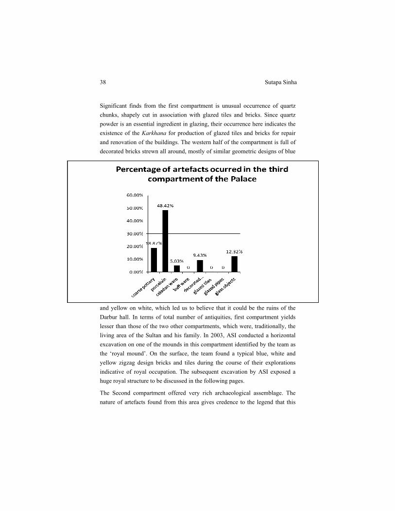
The third compartment of the palace is traditionally known as the Zenana Mahal or Haremsara, the living apartment of the women. It was separated from the second compartment by a brick wall, though it can only be traced from the partly existing foundation of the wall beneath the surface. Entire wall has collapsed and a long hollow tunnel can be found as a result of continuous brick hunting even from the foundation. A stone paved tank on its eastern side marks this quarter. Only five sites have been identified from the cluster of artefacts and architectural fragments on the surface which yielded the usual assemblage of porcelain (48.42%), celadon (5.03%), coarse pottery (18.87%) and decorated bricks (9.43%) of deluxe quality whereas glass ware, glass objects occurred in higher number, i.e. 12.32%.
Therefore the evidence of the surface findings neither denies nor supports the theory that this compartment was exclusively inhabited by the womenfolk of the Palace. Though one might raise a point that the occurrence of higher percentage of glass objects including miniature pots, glass bangles and other delicate objects is an indication of feminine occupation yet, this evidence is not strong enough to arrive at any conclusion. Exploration in the third compartment was greatly hampered by cultivation of seasonal crops and mulberry culture and a thick cluster of mango groves. Beyond the third compartment, an area was located that can be termed as service area of the Palace. At the south-western corner of the Citadel wall, we have found a ruin of a small gateway. Fragments of stone pillars and a door jamb belonging to this gateway are still extant. This gateway in all probability is the backdoor of the citadel meant for the easement of the service people of the Palace. The place is traditionally known as Khirki, the literal meaning of which is "backdoor of a house". This tract of land also falls within modern day mouza of Khirki.
To the east of the Palace, two distinct zones have been identified as the burial ground of the Sultans and their families. We have marked them as Cemetery A & B. The former is located on the north east of the Palace where according to 18th century records27 lay the tomb or Mausoleum of Sultan Husain Shah and
27 Robert Orme, Gawre: Description on its Ruins with four inscriptions taken in the Arabic
Copy, British Library (Oriental and India Office Collections), London, Orme MS ov.

Rediscovering Gaur 41
his descendants. The Cemetery B is situated near the Chika building and adjoining areas. No mausoleum exist in Cemetery A but a large mound filled with scattered pillars, number of tombstones, beautifully ornamented polychrome bricks indicate the ruins of a Royal cemetery. (Fig.13a) The team has even located the remains of the enclosure wall of the cemetery, now in ruins but was extant during the days of Henry Creighton28, who has left us with a brilliant drawing of the site. The glazed bricks collected from this burial site are brilliant and exclusive in design and colours.
The later Ilyas Shahi rulers and their families probably used Cemetery B for burial. A scientific clearance work conducted by the Archaeological Survey of India in 1920s in the area between the Chika Mosque and Gumti Gateway has disclosed the existence of a floor of painted tiles and a mosque with half-damaged stone pillars. A brief report of it was published in Annual Report of the Archaeological Survey of India.29 The report further states that this area was examined with a view to determine the nature of the underground stone cells visible at a short distance towards Gumti gateway. As the digging proceeded it was clear that there were at least three cells, almost 4 feet deep with a terraced floor and walls of dressed stone, were most probably intended to be used as graves. Their openings being closed by rough-hewn slabs of stone placed breadth-wise. (Fig. 13b) As traces of inhumation were discovered in two of the graves, the work was stopped immediately. Our finding from this area also includes traces of a tiled floor, structural pillars and fragments of tombstones strewn here and there. Thus it tallies with the earlier findings of Archaeological Survey of India of a burial ground around the Chika building.
The functional purpose of Chika monument is not clear to us. The building is strikingly similar in the architectural style to the Eklakhi in Pandua, which served as the royal mausoleum of Sultan Jalal al-din Muhammad Shah. The Chika building could well be a mausoleum without the tombstone above the
65.25, folio 171; Creighton, Op. cit., p. 3, pl. no. viii, See also, William Francklin, Journal of a route from Rajemehal to Gaur A.D. 1810-11, Shillong, 1910, p. 2; H. Beveridge, "The Khurshid Jahan Numa of Sayyid Ilahi Bakhsh al Husaini Angrezbadi", Journal of the Asiatic Society of Bengal, Calcutta 1895, No. 3, p. 220.
28 Creighton, Op. cit, pl. viii. 29 ASIAR, 1927-28, p. 43.

42 Sutapa Sinha
ground, which is lost and may have entombed the mortal remains of a principal Sultan of the later Ilyas Shahi house.30
Just to the east of Chika, there is another gateway of the citadel popularly named Gumti Gate, standing on the city wall. This small gateway may have been constructed for the private use of the members of the royal family. This domed structure with its magnificent brick ornamentation on the walls and also on the turrets at the four corners is dissimilar in architectural style to the other gateways of the citadel or of the city. On further left of it is situated the eastern main entrance of the Citadel named Lukochuri Darwaza which is evidently a building of the Mughal period. It is postulated without much evidence that Sultan Shah Shuja used to reside at Gaur briefly, when he had built this gateway. But there is a strong possibility that this later structure was built on the site of a previous gateway, which originally connected the Citadel with the southern part of the city through a raised road. It would be seen later that the court nobility inhabited the area around the southern part of the citadel and therefore an eastern gateway of the Citadel was absolutely necessary for frequent easement. Within the Citadel, the religious structure is Qadam Rasul that enshrines the sacred footprint of Hadrat Muhammad (sm.). Aside Qadam Rasul with its porched liwan, which could be used as a place of worship, surprisingly, trace of no other mosque has been found within the Palace-Citadel complex.
The next zone under discussion is the Noble's Quarter of the city which falls within sector 3 of the working map where we have located eleven sites altogether. The area is situated in the south east of the Citadel and not very far from it, connected with the main arterial road of the city that directly leads to the Kotwali Gate, the southern entrance of the city. It is an area of about four square kilometres around the largest tank of the city locally known as Choto Sagar Dighi, the main source of water supply for the locality. There is another landmark, almost hundred meters north of this tank which is the ruin of Belbari Madrasah, the principal place of learning within the city. (Fig. 14a & 14b) In
30 Cunningham held similar opinion. He states "I am inclined to assign this tomb (Chika) to
Mahamud I himself, the immediate successor of Jalal-ud-din's son. It was probably also the burial place of the different members of Mahmud's family, of his sons Barbak and Fateh, and his Grandson Yusuf." See, Alexander Cunningham, Report of a Tour in Bengal and Bihar in 1879-80. From Patna to Sunargaon. ASI Reports, vol. XV, Delhi 1994 (reprint), p. 56.

Rediscovering Gaur 43
the southern suburb of Gaur, which is presently in Bangladesh, another Madrasah has been located and partly excavated by the Department of Archaeology, Bangladesh,31 known as Darasbari Madrasah. The Belbari Madrasah is at present in utter ruins. The entire structure of the Madrasah building has fallen down and formed a huge mound locally known as Chand Saudagarer Bhita over which are scattered a number of pillars with typical Islamic carvings.
The intellectual class and the supportive apparatus of the administration probably inhabited the area. Exploration conducted by the Team in this sector revealed ruins of extensive habitation in the area between Chhoto Sagar Dighi and the arterial road of the city and also around the Madrasah. A bridge of three arches was found behind the Madrasah ruins where a raised road has crossed a canal flowing in east-west direction. This road was running parallel with the main arterial road from the north of the city as a bypass and perhaps was connecting the Madrasah with another most important part of the city namely, Urban Core, which will be discussed next. The road ends at the south-eastern corner of the Choto Sagar Dighi. The artefacts found from the area such as different type of porcelain shards (32.53%), decorated bricks (22.88%), glazed tiles (8.43%), glazed pipes (8.43%) and other usual assemblage are of exclusive quality and are comparable to those collected from the Royal Centre. A number of structural mounds relieve the topography of the zone, which indicates the remains of residential building.
The quality of the archaeological artefacts found together with the close cluster of ruins of residential structures in proximity of the Royal Centre help to identify the sector as the Noble's Quarter. The quarter was carefully planned for habitation of the elite class and provided with largest source of drinking water in vicinity and other urban amenities such as easy access to the main arterial road of the city, well planned canal made both for carrying of daily waste as well as diffusion of excessive rain water from the large lake on the east, connecting subsidiary roads with other part of the city. The team has also located an enormous structural mound on the west of Choto Sagar Dighi, which is almost undisturbed. The mound is full of stone pillars, stone fragments of architectural components and glazed bricks, tiles and glazed roof tiles. The size and nature of the ruin suggest that this could be a ruin of a mosque, probably 31 Qadir, Op. cit.
44 Sutapa Sinha
the principal one of the noble's quarter. In the map prepared by Henry Creighton (1801)32 and published in 1817, a mosque is indicated in the place where now the ruin stands and the area was named as Sonarganj. A linear habitation can be noticed on the other side of the Choto Sagar Dighi and was probably populated by the service people to cater the community of the noblemen and allied functionaries.
The third important and the largest zone in the city has been termed as Urban Core, comprising of Sectors 1, 2, 4 and 6 of the base map. On the basis of the surface explorations, the area around the Royal Palace stretching from Bara Sona Masjid on the north to the city wall on the south and double embankment on the east to the bank of Bhagirathy on the west may roughly be defined as the Urban Core of the medieval city of Gaur. This part of the city is situated around the Royal Centre in a half circular manner and was warded off from the fringe area by a raised causeway. Density of population here was probably the highest as revealed through the traces of clustered settlements, occurrences of large and small tanks, bridges, mosques, canals, high ways and causeways as well as other structures and monuments.
At the northern end of the Urban Core lies the principal mosque of the city known as Bara Sona Masjid used for the weekly congregational prayer (Sector 6). The area to the west of it is marked by a structural mound with stone pillars scattered around, traces of sewerage system and a large concentration of the usual archaeological assemblages of medium to inferior quality denoting the area to be extensively populated by all classes of people and probably having a market place within it. The discovery of an inscription33 from a mound to the west of Bara Sona Masjid and its alignment to the ruins suggest that some annexe buildings used for educational purpose lay buried within it. The concentration of the antiquities became sparse in the stretch from the south of Bara Sona up to Firuz Minar. The approach towards the Royal Center, significantly lacks signs of settlement. From the travelogue of an unnamed Portuguese interpreter accompanying Antonnio de Britto,34 we came to know that this area was cordoned off to prevent easy ingress of the common people to
32. Creighton, Op. cit, see map. 33 Pratip Kumar Mitra, "A Note on a New Inscription of Sultan Nasir Al-Din Nusrat Shah
of Bengal", Pratna-Samiksha,Vol's 2&3, Journal of the Directorate of Archaeology and Museums, Calcutta 1993-94, pp. 274-277.

Rediscovering Gaur 45
the Royal Area as well as to the Noble's Quarter. Linear habitation pattern is noticeable to the immediate east of the Royal Centre around the Chamkatti mosque. Evidence of settlement found around the canal in an east-west orientation. From this point onwards one can see a group of mosques on the either side of the arterial road namely, Chamkatti, Tantipara and Lattan. Traces of settlements around these mosques are easy to define and each of the mosques was built to cater the respective settlement or mahalla.
Opposite to the Noble's Quarter, (i.e. Sector 4) on the right hand side of the arterial road stands the grand Tantipara Mosque. The size of the mosque and its rich terracotta decoration on the façade and inside, suggests that it used to cater to a large number of people belonging to the elite class. Surprisingly enough, the result of surface exploration in and around the mosque belies the suggestions because the artefacts are of quite inferior quality and their distribution is very sparse and erratic as well. However, we should mention here that a considerable part of this sector is completely unapproachable due to the cultivation of mulberry. On the south and south west of Tantipara mosque, several explorations were conducted between Lattan and Gunmant mosque. This area locally known as Lalbazar falls in the Sector 1 of our base map and altogether nineteen sites have been explored. Gunmant mosque is another magnificent building comparable to Bara Sona Masjid situated on the south western corner of the city. (Fig. 15b) The city wall ran very close to it and the Masjid was connected with the southern part of the city by a raised road. Signs of dense population were observed in the entire stretch of high ground revealing typical cultural assemblage of the period. From the distribution of surface findings, the area can further be subdivided into two distinct zones, one to the west of Lattan mosque and the other around the Gunmant mosque. The surface findings of the former zone consist mostly of sherds of coarse pottery, pieces of porcelain and glassware, glass bangles and cowries of medium quality. This indicates that the area was occupied by common people. The area is full of structural mounds, some of which are cut through to accommodate modern pathways. The sections of the mounds are full of brick bats mixed up with coarse pottery suggesting a congested residential complex. Occasionally, the Team came across with cowry shells and other ordinary artefacts. Porcelain is rare in this part of the settlement. This leads to the assumption that a large population of ordinary class resided here. The Lattan mosque nearby served those people for their daily prayers.

46 Sutapa Sinha
In contrast, the latter zone around the Gunamant mosque yielded artefacts of higher quality and of intriguing variety. These included, beside the usual assemblage of Porcelain, Celadon, buff colour ceramic and coarse pottery, a large hoard of cowries and conches. A few coin hoards were also reported from this particular area of Gaur in different point of time. The nature of surface findings along with the name of this place 'Lalbazar' suggests the occupation of this area by the mercantile community of the city. This area was also densely populated as indicated by the size of the Gunmant mosque which was the Jami mosque of the southern part of the city built earlier by the builder of it while Bara Sona served same purpose in the northern part and built by the Husain Shahi rulers.
The Hindu city Lakshmanavati was most probably located in this area as revealed through a number of stone sculptures of both Hindu and Buddhist pantheon, stone pillars with inscription referring to one Yakshapaladeva in Siddha Matrika script discovered from this area of Lalbazar which are now preserved at the Mahadipur High School, west of Gaur. (Fig. 15a)
To the south of Sector 1 lies the last trail of the main drainage canal of the city joining Chatia Patia35 with the Bhagirathi River and running across the city from east to west. This canal intersects the arterial road near Lattan mosque and a bridge of five arches was constructed over it. Another bridge of seven arches is in the south of Gunamant mosque where the canal again crosses the road that used to join the mosque with other parts of the city. (Fig. 16)
The sector east of the main arterial road i.e. Sector 2 could not be explored thoroughly since a considerable portion of it falls within the territory of modern Bangladesh. The zone is marked by raised causeway starting from a single arched bridge named Nungola on the main canal on the east and runs along the eastern side of the Sagar Dighi through the entire breadth of the city. This causeway cordoned off the Noble's Quarter and urban core from the fringe areas of the city protecting it from inundation. Through the surface exploration carried out in this area the Team has located only five sites which revealed the usual assemblage of coarse pottery, porcelains, celadon and glass-ware though very sparsely distributed. Two bridges, one having a single arch and the other having double arches are situated in this area connecting it with the fringe area
35 H. Blochmann and H.S. Jarrett (tr.), The Ain-I Akbari by Abu’l Fazl ‘Allami, Vol. 2,
Calcutta 1993 (reprint), p. 135.

Rediscovering Gaur 47
of the city. The ruin of a mosque locally known as Mashagidda can still be identified with much difficulty. From the indication of the surface finding the area appears to be inhabited by the people of secondary occupation.
There are also two other distinct functional zones in the city as revealed through the explorations carried out by the Team, namely Garrison Area and Fringe Area.
Garrison Area
A narrow strip of the land stretching from the north of Dakhil Darwaza to the north entrance of the city, i.e. ruins of Phulwari Gate is separated from the other parts of the city by a raised road probably used for military purpose. Within this narrow tract lies a small fort known as Phulbari fort, enclosed by huge mud wall on three sides and river Bhagirathi on the west. Surface exploration conducted in this fort has brought to light a large quantity of iron slag along with other artefacts. The location of the fort is suitable for the army barracks or headquarters having the ordnance factory within it, as the huge quantity of iron slag would suggest. Surface exploration at Phulbari fort area also yielded a good number of coarse pottery and ordinary brickbats and a few good quality porcelain and celadon ware. Behind the Phulbari fort towards east, on the other side of the road that is running from the city wall in north up to the Citadel in the south via Phulbari fort, the Team has located a ruin of a mosque of which there is no reference in any earlier map of Gaur. The stone pillars of the mosque are heavily decorated with exquisite Islamic patterns and dispersed over a structural mound. The mosque might have erected for the troops to offer their daily prayers.
A tract of land between the Garrison area and the main arterial road running parallel to it has a striking topography. The entire area has a shallow basin like formation and full of sandy soil unsuitable for any kind of cultivation as well as human habitation.
To the south of the newly discovered ruins of the mosque and to the east of Phulbari Fort, there is a village called Hatatpara, on a higher ground more suitable for agriculture as well as for settlement. The Team has discovered a burial ground with a number of tombstones embedded in the surface. The largest tombstone (cenotaph) is inscribed with Quranic text though three others are without any inscription. The inscribed tombstone was probably erected to

48 Sutapa Sinha
entomb a group of soldiers who died during a war or due to an epidemic, as the unusual large size of the tombstone indicates.
Fringe Area The area situated between Piyasbari Dighi on the north to the canal end near Choto Sagar Dighi on the south and the arterial road of the city on the west to the double embankment on the east can be termed as the Fringe area of the city. Within this vast area, the portion of land lying beyond the raised causeway and encircling the Noble's Quarter is not accessible. But the area beyond the canal, which runs through the bridge of three arches up to Piyasbari Dighi, is relatively accessible and may have been once populated. From surface exploration conducted in the village Beki, and its surroundings within this zone, the Team has found all the diagnostic artefacts of the Sultanate Gaur though of inferior quality. The area was evidently inhabited by the people of lower income group. This tract is low-lying compared to the other parts of the city and was relatively insecure during the monsoon. Moreover, there was no canal inside to diffuse the water. In the northern end of this area, a huge structural mound overlooking the Piyasbari Dighi (above which the present Dak Banglows of the Zilla Parishad stands), has been identified as the remains of some official buildings, which, according to Abu’l Fazl, were the prison of the city. 36 The exploration work in this area revealed ruins of structures made up of ordinary bricks without embellishment.
The residual part of the city beyond Piyasbari Dighi up to the northern city wall is now a long stretch of agricultural land. The exact use of this area in the Sultanate period is not clear but as suggested earlier, it was probably used for cultivation of crop, not seasonal but regular crop to supply the staple diet of the people. Surface exploration conducted in this area revealed no such trace of habitation. So, it can be labelled as the Buffer Zone of the city.
III
Now, as has been stated earlier, a brief account of the excavations conducted at Gaur by ASI from January 2003 to March 2005 along with a few clearance activities would be furnished. The excavations at Gaur was conducted under the directorship of Dr. Bimal Bandyopadhyay, the then Superintending
36 Blochmann and Jarret, Ibid.

Rediscovering Gaur 49
Archaeologist of Kokata Circle.37 Three sites have been selected, Site 1 and Site 2 in the first compartment of the Palace while Site 3 falls within the second compartment of the Palace. Two structural phases have been encountered in both Site 1 and Site 3 area named as GAR I and GAR III.
In Site 1, i.e. the area adjacent to the stupendous Baisgazi wall was selected for excavation on a mound approximately measuring 700 m (N-S) x 250 to 300 m sufficiently raised from the adjoining area. Traces of brick walls of a structure of lakhauri bricks and reused early bricks and stones have been found in Layer 1. The rammed floor of the rooms with lime coating top, walls and quite a good number of iron nails have been found which possible indicate some sort of wooden superstructure above it. Below this structure in GAR I area has been exposed a huge structural complex of bricks, square in shape within a walled enclosure. (Fig. 17a)
According to the excavator, the entire concept is based on formation of strong criss-cross walls over which series of circular foundation walls are formed covering the area 54 m square. The cross walls sometimes rest on sand cushions and the brick circles are of uniform dimensions. Most of these have a hole (30- 40 cm in diameter) on their sides presumably for passing water as no other purpose could be established. The mortar used is essentially sticky mud. The existence of symmetrical holes is not only limited to the circular foundation like construction; but on the enclosure walls also such connecting holes have been noticed pointing to the passage of water through them strongly. On the top, there are some columns at regular interval which have circular holes possibly for erecting or fixing wooden poles for superstructure and from some of them charred wooden logs have also been found to confirm the hypothesis. On the whole the utilitarian aspect of this huge complex is enigmatic. But the engineering feat is indeed splendid. (Fig. 17b) Bricks are laid in sticky mud
37 Bimal Bandyopadhyay, ‘Recent Excavation at the area adjacent to Baisgazi Wall at Gaur
and Scientific Clearance at some adjooning areas, District: Maldah, West Bengal’, Journal of Bengal Art, Vols. 9&10, 2004-2005, Dhaka 2006, pp. 15-33; Indian Archaeology 2002-03- A Review, “Excavation at Palace Area, Gaur, District Maldah”, New Delhi, 2009, pp.324-331; Indian Archaeology 2003-04- A Review, “Excavation at Baisgazi Wall Known as Palace Area of Ancient Gaur, District Maldah”, New Delhi 2011, pp. 329-34.

50 Sutapa Sinha
mortar and nothing else and no regular bonding method has been followed. No lakhauri bricks have been used in this structure strongly indicates its construction before the Mughal occupation at the site. Moreover, mention may be made that no beam was used in this structure.
In Site 3 area, a part of a semi-circular bastion like stone structure has been exposed with 14 courses of dressed stone slabs set in mud mortar. Our surface survey at this area conducted at least 10 years back also noticed this bastion but without the detail of the construction method. (Fig. 18a) According to the excavator it could be the portion of Baisgazi Wall on the western side of the mound. He also added the fact that due to brick robbing the exposed top of the wall is extremely damaged and possibly the wall was repaired and mended in Mughal period since the facing of it made of lakhauri brick.
Site 2 area is located on the western peripheral zone of the mound from where the land is sloping towards the river which is presently a dried up bed used for cultivation. The top of an arched structure was already visible here and to find out the link between this and an already exposed remains on west of it, ASI team tapped this area and interesting findings have been located. The most interesting feature noticed in this part is the discovery of strong iron chains, the inner part of which are embedded in the walls. Besides this, some hook like devices have also been noticed. All these evidence give clear indication to the anchoring of boats and it may be assumed that the river Ganga used to flow pretty close to it. A series of strong walls and the arched guard room like structure would suggest that it was part of the western enclosure wall of the Palace. (Fig.18b)
Apart from these excavations, two scientific clearance works have also been conducted, one at the site of tombs of Husain Shah and the other is a bit away from the citadel complex further south-east at the mound of Chand Saudagarer Bhita. Location of the Husain Shah’s tomb was enigmatic and earlier scholars were of different opinion regarding it location outside the palace on north-eastern side. The clearance work undertaken at the site on the north east corner outside the Baisgazi wall covered with jungle unveiled an enclosure wall laid in brick covering an area of 27.70 m x 14.80 m. From the remains of the structure it may be ascertained that there were four minarets at the corners of the
Rediscovering Gaur 51
building, bases with a diameter of 2.20 m. The remains of the minarates still contain 2-3 layers of blue enamelled wedge shaped brick. The inner floor of lime concrete, a fragmentary stone column at the entrance and a number of other architectural member in stone are among the other finds.
Trial clearance at the mound known as Chand Saudagorer Bhita was undertaken with an objective to expose the wall noticed there and to trace the material evidence of pre-sultanate era. A trial trench of 10m x 10m at the western corner of the mound yielded successive floors of lime surkhi and brick soling, a brick wall, its foundation and lime concrete floor along with a exquisitely ornamental stone pillar with motifs of a rekha temple, human figures and foliage. It may also be mentioned that the entire mound is strewn over with stone pillars. These evidences led the excavator to conclude that the site inhumed a pre-Islamic architecture.38
We are, however, still inclined to believe this mound represents the site of the Belbari madrasah because finding of pre-Islamic building material from a huge structural mound cannot be the only criteria to determine its age unless further excavation reveals its ground plan and other components to affirm the nature of the structure. There are so many examples in Bengal as well as in India where pre-Islamic architectural elements were widely re-used in an Islamic monument. Acknowledgements
The antiquities illustrated in Figures 2-7 and 12 belong to the collection of the State Archaeological Museum, West Bengal barring 2g and 4a and these are published through the courtesy of the Dirctorate of Archaeology and , Museums, West Bengal. The artefact illustrated in Fig. 2g (2h is the reverse of the same) belongs to the collection of Gaur Social Welfare Mission and published through courtesy of the Mission. Two stone pillars and antiquities illustrated respectively in Fig. 15 and Fig. 1 belong to the collection of Mahadipur High School, Mahadipur, Malda and published through courtesy of the school.
38 Bandyopadhyay, Op. cit., 2006, p. 29.

52 Sutapa Sinha
Photographic Credit: Figures 1, 2, 4-7, 12, 16: Shri Siharan Nandy, Directorate of Archaeology and Museums, Government of West Bengal; Figures 13 and 15a: Shri Pratip Kumar Mitra, Former Keeper, State Archaeological Museum, West Bengal; Figure 17b: Courtesy CASTEI Newsletter.
Drawing and Map Credit: Figure 3: Shri Kaushik Halder, Ex- Directorate of Archaeology and Museums, Government of West Bengal; Maps in Figures 8 & 9: Shri Debanjan Mitra, Deccan College, Pune.
Editing of illustrations: Shri. Raktim Baran Chakraborty, Kolkata.
Illustrations
Fig. 1: Coarse pottery: bottle necked miniature vessels.

Rediscovering Gaur 53
Fig. 2: Porcelains: sherds are mostly blue on white, white and blue of various shapes
and sizes.

54 Sutapa Sinha
Fig. 3: Reconstruction drawing of porcelain sherds. Fig. 4: a) Celadon ware: sherd of a footed bowl olive green in colour with self-
designs; b) spouts of buff-coloured ceramic; c) Glazed ware: a bowl and a broken shallow basin.

Rediscovering Gaur 55
Fig. 5: Glazed floor tiles: a) polychrome of different shapes and sizes; b) monochrome
of different shapes and sizes. Fig. 6a: Glazed bricks: bi-chrome.

56 Sutapa Sinha
Fig. 6b: Glazed bricks: polychrome of different shapes and sizes. Fig. 7: a) Unglazed bricks: decorated; b) Glazed half-circular roof tiles, sometimes
with a decorated rim; c) Small glass objects like miniature bottles, small cups and pieces of glass bangles.
Rediscovering Gaur 57
Fig. 8: Digital Map showing sector-wise distribution of explored sites and different
zones.

58 Sutapa Sinha
Fig. 9: Digital map of Sector 5 showing cluster of sites. Fig. 10: Henry Creighton’s painting of Chand Gate (now disappeared) and photograph
of its inscription now affixed to Minaronwali Mosque in Mahadipur, P.S. English Bazar.

Rediscovering Gaur 59
Fig. 11: a) A site in the first compartment of the Palace with glazed bricks and tiles
scattered over; b) Bi-chrome tiled floor at the second compartment of the Palace, now much worn-out.

60 Sutapa Sinha
Fig. 12: Blue on white porcelain sherds with inscriptions in proto-Bengali script. Fig. 13: a) Site of Cemetery A with cenotaph and pillar base strewn over; b) Area
around Chika building designated as Cemetery B.

Rediscovering Gaur 61
Fig. 14: a) Choto Sagar Dighi in Noble’s quarter; b) mound of Belbari madrasah with
large numbers of stone pillars strewn over it.

62 Sutapa Sinha
Fig. 15: a) Pre-Islamic stone pillars with inscription referring Yakshapaladeva
preserved in Mahadipur High School; b) Gunmant mosque, the Jami mosque in the south of the City following plan of Adina in Pandua.

Rediscovering Gaur 63
Fig. 16: a) Bridge of five arches on the Shibganj Road; b) Bridge of seven arches near
Gunmant Mosque.

64 Sutapa Sinha
Fig. 17: Excavation in Gaur by ASI: a) Structure within a walled enclosure; b) The full
view of the enigmatic underground brick structure exposed through excavation.

Rediscovering Gaur 65
Fig. 18: Excavation in Gaur by ASI: a) A part of a semi-circular bastion like structure;
b) Arched guard room with embedded iron chain.