Recreational Fishing Regulations for Gulf of Mexico...
32
Recreational Fishing Regulations for Gulf of Mexico Federal Waters For Species Managed by the Gulf of Mexico Fishery Management Council May 7, 2015
Transcript of Recreational Fishing Regulations for Gulf of Mexico...

Recreational Fishing Regulations for Gulf of Mexico Federal WatersFor Species Managed by the Gulf of Mexico Fishery Management Council
May 7, 2015

This publication was prepared for general informational purposes and has no legal force or effect. Fishing regulations are subject to change. Check for updates by visiting www.gulfcouncil.org.
Gulf of Mexico Fishery Management Council2203 North Lois AvenueSuite 1100Tampa, Florida 33607
A publication of the Gulf of Mexico Fishery Management Council Pursuant to National Oceanic and Atmospheric Administration Award No. NA05NMF4410011.
For more information call 888-833-1844.
1
Table of Contents
About Us 2
Recreational Regulations
Reef Fish 3
Coastal Migratory Pelagics 6
Shellfish, Coral, and Other Species 7
Recreational Permit Requirements 8
Additional Rules 9
Highly Migratory Species 10
Species Identification 12
Measurement Guidelines 14
Marine Sanctuaries & Closures 15
Gulf of Mexico Federal Waters 22
Important Phone Numbers 23
Regulation Changes and Updates 25
Gulf of Mexico Fishery Management Council 2203 N. Lois AvenueSuite 1100Tampa, Florida 33607
2
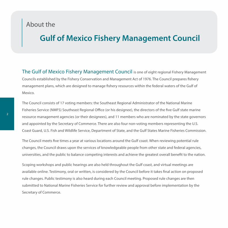
About the
Gulf of Mexico Fishery Management Council
The Gulf of Mexico Fishery Management Council is one of eight regional Fishery Management
Councils established by the Fishery Conservation and Management Act of 1976. The Council prepares fishery
management plans, which are designed to manage fishery resources within the federal waters of the Gulf of
Mexico.
The Council consists of 17 voting members: the Southeast Regional Administrator of the National Marine
Fisheries Service (NMFS) Southeast Regional Office (or his designee), the directors of the five Gulf state marine
resource management agencies (or their designees), and 11 members who are nominated by the state governors
and appointed by the Secretary of Commerce. There are also four non-voting members representing the U.S.
Coast Guard, U.S. Fish and Wildlife Service, Department of State, and the Gulf States Marine Fisheries Commission.
The Council meets five times a year at various locations around the Gulf coast. When reviewing potential rule
changes, the Council draws upon the services of knowledgeable people from other state and federal agencies,
universities, and the public to balance competing interests and achieve the greatest overall benefit to the nation.
Scoping workshops and public hearings are also held throughout the Gulf coast, and virtual meetings are
available online. Testimony, oral or written, is considered by the Council before it takes final action on proposed
rule changes. Public testimony is also heard during each Council meeting. Proposed rule changes are then
submitted to National Marine Fisheries Service for further review and approval before implementation by the
Secretary of Commerce.

3
Recreational Fishing RegulationsReef Fish
Snappers
Species Minimum Size Limit Season Daily Bag Limit
Red Snapper 16” total length Opens June 1Private Angler season closes
12:01 am local time June 11
Federal CFH season closes
12:01 am local time July 15
2 per person
Captain & crew may not retain a bag limit
Vermilion 10” total length Year round 10 per person within the 20-reef fish combined total
Lane 8” total length Year round 20 per person within the 20-reef fish combined total
Gray (Mangrove)MuttonYellowtail & CuberaQueenBlackfinSilkWenchman
12” total length16” total length12” total lengthnonenonenonenone
Year roundYear roundYear roundYear roundYear roundYear roundYear round
10 per person within the 10-snapper combined total
Includes all snappers except red, vermilion, and lane

4
Reef Fish
Groupers
Species Minimum Size Limit Season Daily Bag LimitShallow-water GroupersBlackYellowfinScampYellowmouth
Red
Gag
22” total length20” total length16” total lengthnone
20” total length
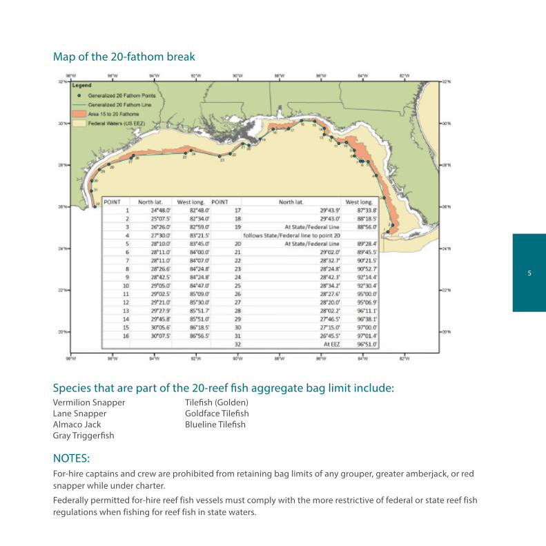
All Shallow-water grouper closed 2/1 - 3/31 when fishing beyond the 20-fathom break. See map next page
4 per person combined 4-grouper total
2 per person within the 4-fish combined grouper total
22” total length July 1 - December 2Subject to in-season closure
2 per person within the 4-fish combined grouper total
Deep-water GroupersYellowedgeSnowy
Speckled HindWarsaw
nonenone
Year roundYear round
4 per person combined grouper total
nonenone
Year roundYear round
1 per vessel, included in the 4-fish combined grouper total
Other Reef Fish
Species Minimum Size Limit Season Daily Bag Limit
Hogfish 12” fork length Year round 5 per person
Gray Triggerfish 14” fork length Closed June 1 - July 31NOTE: In-season Closure effective Feb 7 - Dec 31.
2 per person within the 20-reef fish combined total
Greater Amberjack 30” fork length
(34” size limit increase pending)
Closed June 1 - July 31Subject to in-season closure
1 per person Captain & crew may not retain a bag limit
Lesser AmberjackBanded Rudderfish
14” - 22” fork length 14” - 22” fork length
Year roundYear round
5-fish combined total
Almaco Jack None Year round 20 within the 20-reef fish combined total
Protected Groupers: Goliath (Jewfish) harvest and possession is prohibited.
NOTE: When fishing in state waters off Monroe County South Atlantic regulations apply.
5
NOTES:For-hire captains and crew are prohibited from retaining bag limits of any grouper, greater amberjack, or red snapper while under charter.
Federally permitted for-hire reef fish vessels must comply with the more restrictive of federal or state reef fish regulations when fishing for reef fish in state waters.
Species that are part of the 20-reef fish aggregate bag limit include:Vermilion Snapper Tilefish (Golden)Lane Snapper Goldface TilefishAlmaco Jack Blueline TilefishGray Triggerfish
Map of the 20-fathom break
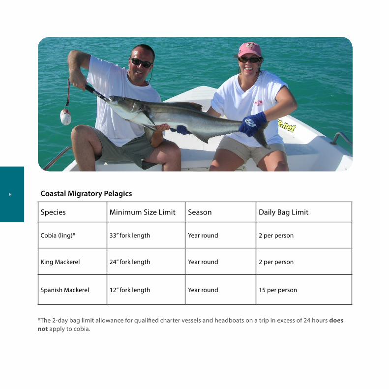
6 Coastal Migratory Pelagics
Species Minimum Size Limit Season Daily Bag Limit
Cobia (ling)* 33” fork length Year round 2 per person
King Mackerel 24” fork length Year round 2 per person
Spanish Mackerel 12” fork length Year round 15 per person
*The 2-day bag limit allowance for qualified charter vessels and headboats on a trip in excess of 24 hours does not apply to cobia.

7
Shellfish
Species Minimum Size Limit Season Daily Bag Limit
Spiny Lobster* More than 3” carapace. Divers must measure in water.
8/6 - 3/31A special 2-day, non-trap recreational season opens the last consecutive Wednesday and Thursday in July
6 per person, no transfer at sea between boats. During the 2-day special season - 12 per person off Florida, except 6 per person for Monroe County, Florida Keys.
*Removal of tail prohibited at sea. See commercial regulations for trap use. No spears, hooks, or piercing devices. No taking of egg-bearing spiny or slipper lobsters.
Coral and Other Species
Species Notes
Live Rock Harvest and possession of live rock is prohibited, except for permitted aquaculture operations. Call 727-824-5763.
Other Marine Life Organisms
Marine life organisms from the EEZ harvested or possessed by Florida residents or landed in Florida are subject to Florida’s Marine Life Rule. Contact the Florida Fish and Wildlife Commission for more information at 850-487-3122.
Other Species
Red Drum Illegal to harvest or possess in federal waters.

8
Recreational Permit Requirements
Permit Required for:
Charter vessel/headboat coastal pelagics permit Charter vessel and headboats fishing for mackerels, cobia, little tunny, cero, dolphin, bluefish. NOTE: Issuance of new permits is under a moratorium effective 6/16/2003.
Charter vessel/headboat reef fish permit Charter vessels and headboats fishing for snappers, groupers, amberjack, tilefish, hogfish, and gray triggerfish. NOTE: Issuance of new permits is under a moratorium effective 6/16/2003.
Highly migratory species (HMS) charter/headboat permit
All charter or headboats that fish for or possess highly migratory species.
HMS recreational angling permit Owners of vessels used to fish recreationally for Atlantic HMS - Atlantic tunas (other than blackfin), billfish, sharks, and swordfish.

9
Additional RulesTwo-Day Bag Limit Persons on qualified charter vessels or headboats with two captains for trips in excess
of 24 hours may possess a 2-day bag limit of reef fish, king mackerel, and Spanish mackerel. One-day bag limits apply to all other species and trips, regardless of length.
Head & Fins Attached All fish, except for bait and oceanic migratory species, taken from federal waters must have heads and fins intact through landing. Up to 1.5 pounds of finfish per person is exempt from this rule for personal consumption, provided the vessel is equipped to cook such finfish.
For-Hire Captains and Crew
For-hire captains and crew are prohibited from retaining bag limits of any grouper, red snapper, or greater amberjack while under charter.
Federally Permitted For-Hire Reef Fish Vessels
Federally permitted for-hire reef fish vessels must comply with the more restrictive of federal or state reef fish regulations when fishing for reef fish in state waters.
Reef Fish as Bait The use of federally managed reef fish as bait is prohibited.
Non-Stainless Steel Circle Hooks
Non-stainless steel circle hooks, along with dehooking devices, are required when angling for reef fish in federal waters.
Gear Reef fish gear is limited to no more than 3 hooks in a special management zone off of Alabama. Nonconforming gear is restricted to bag limit. For reef fish without a bag limit, nonconforming gear is restricted to 5% by weight of all fish onboard.
Stressed Areas Use of roller trawls and power heads is prohibited in designated stressed areas. Stressed areas for reef fish begin at the shoreward boundary of federal waters and generally follow the 10 fathom contour from the Dry Tortugas to Sanibel Island; the 20 fathom contour to Tarpon Springs; the 10 fathom contour to Cape San Blas; the 25 fathom contour to south of Mobile Bay; the 13 fathom contour to Ship Island, Mississippi; the 10 fathom contour off Louisiana; and the 30 fathom contour off Texas.
Sale of Recreationally Caught Reef Fish
Reef fish taken under the recreational bag limit may not be sold.
Care and Release of Incidental Catch of Smalltooth Sawfish and Sea Turtles
Operators of vessels with Gulf of Mexico reef fish commercial or charter vessel/head-boat permits must comply with guidelines for proper care and release of incidentally caught smalltooth sawfish and sea turtles and must possess onboard specific gear to ensure proper release of such species.

10
Highly Migratory SpeciesAll HMS species, except blackfin tuna, require an HMS Angling Category permit from NOAA Fisheries. Permits are available by calling 888-872-8862, or by visiting www.nmfspermits.com. No sale permitted for HMS species caught under an angling permit. Additional recreational reporting requirements apply for swordfish, billfish, and Atlantic bluefin tuna. For complete HMS regulations contact NOAA Fisheries HMS Management Division at 301-713-2347, or visit www.nmfspermits.com.
For updates on tuna quota monitoring and tuna retention limit adjustments, anglers may call the Atlantic Tunas Information Line at 888-872-8862 or visit www.nmfspermits.com. For more information on tunas, contact the HMS Management Division at 978-281-9260. Recreational swordfish and billfish landings should be reported to 800-984-5528.
Species Minimum Size Limit Season Daily Bag Limit
Tuna
Bluefin
BigeyeYellowfinAlbacoreSkipjackBlackfin
27” curved fork length
27” curved fork length27” curved fork lengthNoneNoneNone
Year roundYear roundYear roundYear roundYear round
Bag limits are subject to sub-quotas by size and permit categories, change seasonally, and are reduced to zero when subquotas are filled
None3 per personNoneNoneNone
Billfish Minimum size lower jaw to fork
Blue MarlinWhite MarlinSailfish
99” lower jaw66” fork length63” fork length
Year roundYear roundYear round
NoneNoneNone
Longbill Spearfish HARVEST PROHIBITED
Swordfish Whole fish: 47” lower jaw to tail
Year round 1 per person; max 4 per vessel (6 per vessel for charter boats; 15 per vessel for headboats)
11
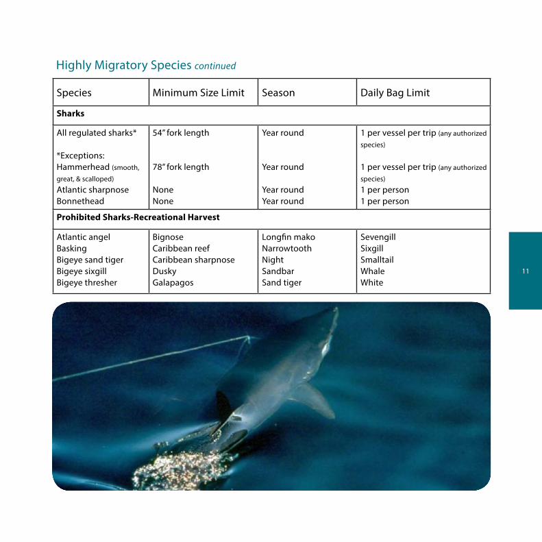
Highly Migratory Species continued
Species Minimum Size Limit Season Daily Bag Limit
Sharks
All regulated sharks*
*Exceptions:Hammerhead (smooth,
great, & scalloped)
Atlantic sharpnoseBonnethead
54” fork length
78” fork length
NoneNone
Year round
Year round
Year roundYear round
1 per vessel per trip (any authorized
species)
1 per vessel per trip (any authorized
species)
1 per person1 per person
Prohibited Sharks-Recreational Harvest
Atlantic angelBaskingBigeye sand tigerBigeye sixgillBigeye thresher
BignoseCaribbean reefCaribbean sharpnoseDuskyGalapagos
Longfin makoNarrowtoothNightSandbarSand tiger
SevengillSixgillSmalltailWhaleWhite
12
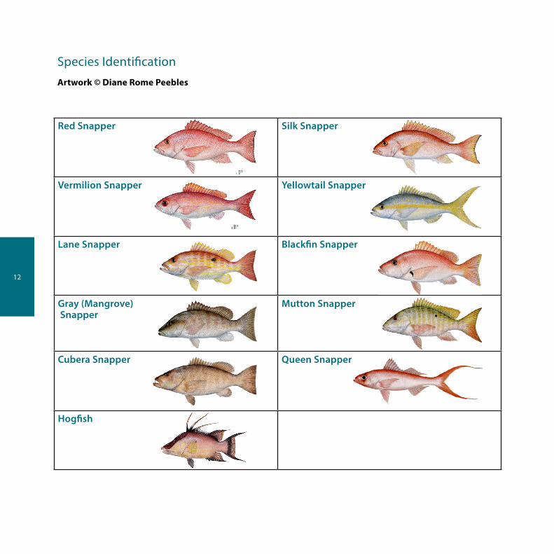
Species IdentificationArtwork © Diane Rome Peebles
Red Snapper Silk Snapper
Vermilion Snapper Yellowtail Snapper
Lane Snapper Blackfin Snapper
Gray (Mangrove) Snapper
Mutton Snapper
Cubera Snapper Queen Snapper
Hogfish

13
Species Identification continued
Artwork © Diane Rome Peebles
Black Grouper Greater Amberjack
Gag Grouper Lesser Amberjack
Red Grouper Banded Rudderfish
Yellowmouth Cobia (ling)
Yellowfin Spanish Mackerel
Scamp King Mackerel

14
Measurement GuidelinesFork length: the straight-line distance from the tip of the head (snout) to the rear center edge of the tail (caudal fin).
Total length: the straight-line distance from the tip of the snout to the tip of the tail (caudal fin), excluding any caudal filament, while the fish is lying on its side. The mouth of the fish may be closed and/or the tail may be squeezed together to give the greatest overall measurement.
Curved fork length: the tip of the jaw to form of tail measured along the contour of the middle of the body.
Carcass length: the curved measure from posterior edge of gill opening to anterior portion of caudal keel.
15
Marine Sanctuaries and Area ClosuresFlower Garden Banks National Marine SanctuaryBelow is a summary of regulated activity within the FGBNMS. For the full text, contact the Sanctuary office at 409-621-5151 or visit www.flowergarden.noaa.gov.
Fishing and Related ActivitiesThe following activities are generally prohibited:
• Injuring, catching, harvesting, collecting or feeding, or attempting to injure, catch, harvest, collect or feed, any fish within the sanctuary by use of any gear, device, equipment or means (e.g. spear guns, nets) except by use of conventional hook and line gear.
• Possessing (except while passing through the sanctuary without interruption) any fishing gear, device, equipment, or means except conventional hook and line gear.
• Possessing or using explosives or releasing electrical charges within the sanctuary.
Conventional hook and line gear means any fishing apparatus operated aboard a vessel and composed of a single line terminated by a combination of sinkers and hooks or lures and spooled upon a reel that may be hand or electrically operated, hand-held or mounted.
Anchoring and MooringThe following activities are prohibited:
• Anchoring any vessel within the Sanctuary.• Mooring a vessel over 100 feet in registered length on a Sanctuary mooring buoy.
DischargesDischarging or depositing any material or other matter within the Sanctuary is prohibited, with the following exceptions:
• Fish, fish parts, chumming materials or bait used in or resulting from fishing with conventional hook and line gear in the sanctuary.
• Clean effluent from an operable Type I or Type II marine sanitation devise (MSD).• Clean water generated by routine vessel operations (e.g. engine exhaust, cooling water, deck wash down,
and gray water), excluding oily wastes from bilge pumping.
Injury to or Possession of Sanctuary ResourcesThe following activities are generally prohibited:
• Injuring or removing, or attempting to injure or remove, any coral or other bottom formation, coralline algae or other plant, marine invertebrate (e.g., spiny lobster, queen conch, shell, sea urchin) brine-seep biota or carbonate rock.
• Possessing within the Sanctuary (regardless of where collected), any coral or other bottom formation, coralline algae or other plant, or fish (except for fish caught by use of conventional hook and line gear).
• Drilling into, dredging, or otherwise altering the seabed of the sanctuary; or constructing, placing, or abandoning any structure, material, or other matter on the seabed of the Sanctuary.

16
Marine Sanctuaries and Area Closures continued
Flower Garden Banks National Marine Sanctuary Boundary Coordinates (NAD)
East Flower Garden Bank Boundary Coordinates:
Position Latitude Longitude
A 27°59’14.4” N 93°38’58.2” W
B 27°59’14.4” N 93°34’03.5” W
C 27°52’36.5” N 93°34’03.5” W
D 27°52’36.5” N 93°38’58.2” W
A 27°59’14.4” N 93°38’58.2” W
West Flower Garden Bank Boundary Coordinates:Position Latitude Longitude
A 27°55’22.8” N 93°53’09.6” W
B 27°55’22.8” N 93°46’46.0” W
C 27°49’03.0” N 93°46’46.0” W
D 27°49’03.0” N 93°53’09.6” W
A 27°55’22.8” N 93°53’09.6” W
17
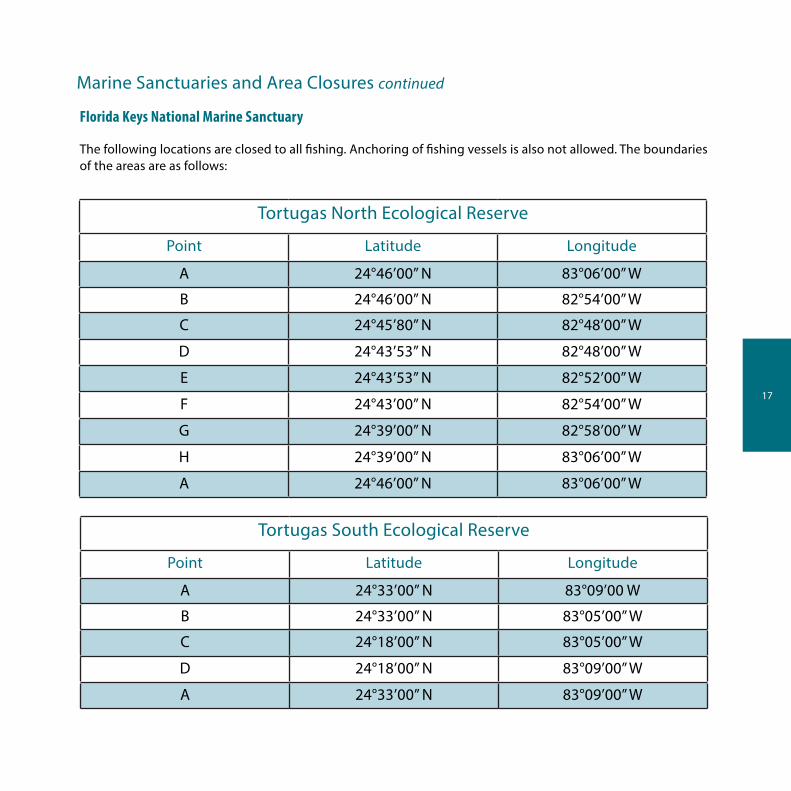
Tortugas North Ecological Reserve
Point Latitude Longitude
A 24°46’00” N 83°06’00” W
B 24°46’00” N 82°54’00” W
C 24°45’80” N 82°48’00” W
D 24°43’53” N 82°48’00” W
E 24°43’53” N 82°52’00” W
F 24°43’00” N 82°54’00” W
G 24°39’00” N 82°58’00” W
H 24°39’00” N 83°06’00” W
A 24°46’00” N 83°06’00” W
Florida Keys National Marine Sanctuary
The following locations are closed to all fishing. Anchoring of fishing vessels is also not allowed. The boundaries of the areas are as follows:
Tortugas South Ecological Reserve
Point Latitude Longitude
A 24°33’00” N 83°09’00 W
B 24°33’00” N 83°05’00” W
C 24°18’00” N 83°05’00” W
D 24°18’00” N 83°09’00” W
A 24°33’00” N 83°09’00” W
Marine Sanctuaries and Area Closures continued
18
Marine Sanctuaries and Area Closures continued
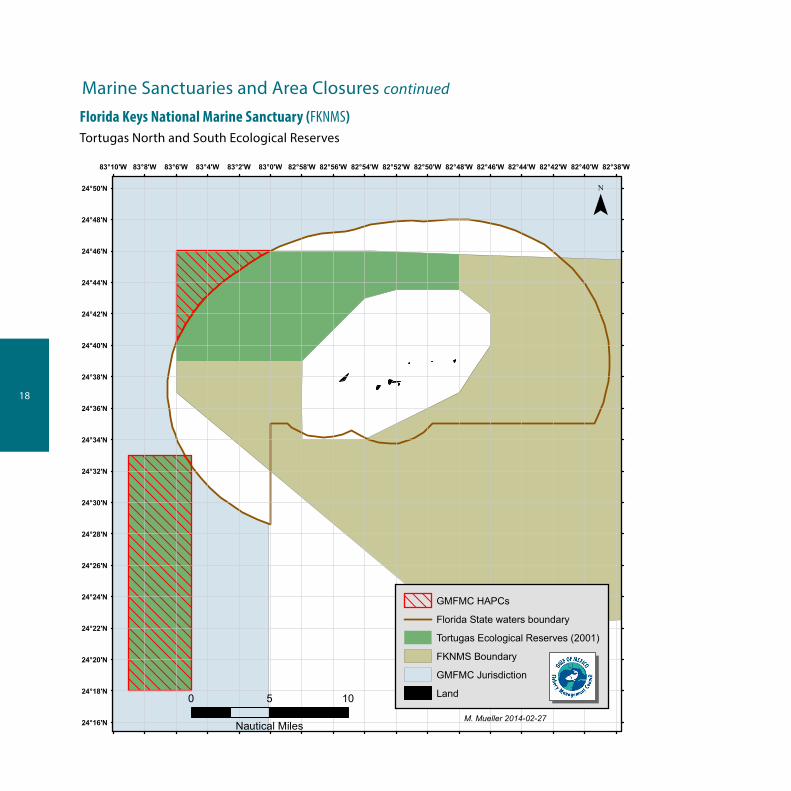
Florida Keys National Marine Sanctuary (FKNMS)Tortugas North and South Ecological Reserves
82°38'W82°40'W82°42'W82°44'W82°46'W82°48'W82°50'W82°52'W82°54'W82°56'W82°58'W83°0'W83°2'W83°4'W83°6'W83°8'W83°10'W
24°50'N
24°48'N
24°46'N
24°44'N
24°42'N
24°40'N
24°38'N
24°36'N
24°34'N
24°32'N
24°30'N
24°28'N
24°26'N
24°24'N
24°22'N
24°20'N
24°18'N
24°16'N
GMFMC HAPCs
Florida State waters boundary
Tortugas Ecological Reserves (2001)
FKNMS Boundary
GMFMC Jurisdiction
Land
¯
0 5 10
Nautical MilesM. Mueller 2014-02-27

19
Marine Sanctuaries and Area Closures continued
Madison-Swanson Marine Reserve:Position Latitude Longitude
A 29°17’ N 85°50’ W
B 29°17’ N 85°38’ W
C 29°06’ N 85°38’ W
D 29°06’ N 85°50’ W
A 29°17’ N 85°50’ W
Steamboat Lumps Marine Reserve:Position Latitude Longitude
A 28°14’ N 84°48’ W
B 28°14’ N 84°37’ W
C 28°03’ N 84°37’ W
D 28°03’ N 84°48’ W
A 28°14’ N 84°48’ W
The following locations off the west-central coast of Florida are closed to reef-fish fishing year round. Surface trolling for species other than reef fish is allowed May 1 through October 31.

20
Marine Sanctuaries and Area Closures continued
The Edges Coordinates:Position Latitude Longitude
A 28°51’00” N 85°16’00” W
B 28°51’00” N 85°04’00” W
C 28°14’00” N 84°42’00”W
D 28°14’00” N 84°54’00” W
A 28°51’00” N 85°16’00” W
The Edges 40 fathom contour is closed January 1 through April 30 to all fishing. The Edges is a 390 nautical square mile region northwest of Steamboat Lumps.
Middle GroundsPosition Latitude Longitude
A 28°42.5’ N 84°24.8’ WB 28°42.5’ N 84°16.3’ WC 28°11.0’ N 84°00.0’WD 28°11.0’ N 84°07.0’ WE 28°26.6’ N 84°24.8’ WA 28°42.5’ N 84°24.8’ W
Fishing with a bottom longline, bottom trawl, dredge, pot, or trap is prohibited year-round.

21
Marine Sanctuaries and Area Closures continued
Fishing with a bottom longline, bottom trawl, buoy gear, pot, or trap and bottom anchoring by fishing vessels are prohibited year-round.
Pulley RidgePosition Latitude Longitude
A 24°58’18” N 83°38’33” WB 24°58’18” N 83°37’00” WC 24°41’11” N 83°37’00”WD 24°40’00” N 83°41’22” WE 24°43’55” N 83°47’15” WA 24°58’18” N 83°38’33” W
McGrail BankPosition Latitude Longitude
A 27°59’06.0”N 92°37’19.2” WB 27°59’06.0” N 92°32’17.4” WC 27°55’55.5” N 92°32’17.4”WD 27°55’55.5” N 92°37’19.2” WA 27°59’06.0” N 92°37’19.2” W
A 28°10’38.3” N 94°18’36.5” W
B 28°10’38.3” N 94°17’06.3” W
C 28°09’18.6” N 94°17’06.3” W
D 28°09’18.6” N 94°18’36.5” W
A 28°10’38.3” N 94°18’36.5” W
Stetson Bank Boundary Coordinates:Position Latitude Longitude
22
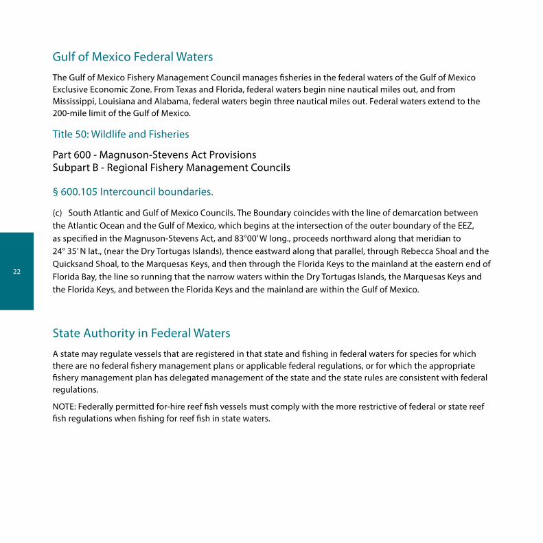
Gulf of Mexico Federal Waters
The Gulf of Mexico Fishery Management Council manages fisheries in the federal waters of the Gulf of Mexico Exclusive Economic Zone. From Texas and Florida, federal waters begin nine nautical miles out, and from Mississippi, Louisiana and Alabama, federal waters begin three nautical miles out. Federal waters extend to the 200-mile limit of the Gulf of Mexico.
Title 50: Wildlife and Fisheries
Part 600 - Magnuson-Stevens Act ProvisionsSubpart B - Regional Fishery Management Councils
§ 600.105 Intercouncil boundaries.
(c) South Atlantic and Gulf of Mexico Councils. The Boundary coincides with the line of demarcation between the Atlantic Ocean and the Gulf of Mexico, which begins at the intersection of the outer boundary of the EEZ, as specified in the Magnuson-Stevens Act, and 83°00’ W long., proceeds northward along that meridian to 24° 35’ N lat., (near the Dry Tortugas Islands), thence eastward along that parallel, through Rebecca Shoal and the Quicksand Shoal, to the Marquesas Keys, and then through the Florida Keys to the mainland at the eastern end of Florida Bay, the line so running that the narrow waters within the Dry Tortugas Islands, the Marquesas Keys and the Florida Keys, and between the Florida Keys and the mainland are within the Gulf of Mexico.
State Authority in Federal Waters
A state may regulate vessels that are registered in that state and fishing in federal waters for species for which there are no federal fishery management plans or applicable federal regulations, or for which the appropriate fishery management plan has delegated management of the state and the state rules are consistent with federal regulations.
NOTE: Federally permitted for-hire reef fish vessels must comply with the more restrictive of federal or state reef fish regulations when fishing for reef fish in state waters.

23
Important Phone Numbers
NMFS Operations Branch 727-824-5305
NMFS Permits and Regulations Branch (see below for tuna permit applications)
877-376-4877
To apply for permits online visit www.nmfspermits.com
NMFS nationwide federal fishing violations hotline 800-853-1964
NMFS 24-hour tuna information line (also for tuna permits) 888-872-8862
NMFS Highly Migratory Species Division 301-713-2347
NMFS Swordfish/Billfish Recreational Reporting 800-894-5528
Flower Garden Banks National Marine Sanctuary 409-621-5151
Florida Keys National Marine Sanctuary 305-809-4700
South Atlantic Fishery Management Council 843-571-4366
Gulf States Marine Fisheries Commission 228-875-5912
U.S. Coast Guard, 7th District (Florida east of St. Marks) 305-415-6781
U.S. Coast Guard, 8th District (St. Marks, Florida to Texas) 504-671-2245
Regional NMFS Office for Law Enforcement 727-824-5344
NMFS Enforcement Field Offices:
St. Petersburg, Florida Marathon, Florida Niceville, Florida Slidell, Louisiana Galveston, Texas Harlingen, Texas
727-824-5344305-743-3110850-729-8628985-643-6232409-770-0812956-423-3450

24
Important Phone Numbers continued
State Agencies
Alabama Department of Conservation & Marine Resources
Information or to report state fishing violations
24-Hour voice mail to report state fishing violations
251-861-2882
251-986-7576
251-476-1256
Florida Fish & Wildlife Conservation Commission Information
To report state fishing violations
Cellular phone
850-488-4676
850-488-9924
888-404-3922
*FWC
Louisiana Department of Wildlife & Fisheries Information
To report state fishing violations
225-765-2800
800-442-2511
Mississippi Department of Marine Resources Information and to report state fishing violations
228-374-5000
Texas Parks & Wildlife Department Information
To report state fishing violations
800-792-1112
800-792-game

25
Regulation Changes and Updates
Supplemental “update sheets” will be published periodically to reflect changes in fishing regulations implemented since this pamphlet was published. For up-to-date regulations visit www.gulfcouncil.org or download our free regulations app. Just visit the Android Market or iTunes and search for “Gulf Council”.
NOTE: The Official Electronic Code of Federal Regulations for 50 CFR 622 for Fisheries of the Caribbean, Gulf of Mexico and South Atlantic is available online. Please visit www.gpoaccess.gov/cfr/index.html.
Photos courtesy of: Jeff Berman, Mark Braxton, Ben Leininger, Mark Miller, Emily Muehlstein, Florida Sea Grant, NOAA Photo Library, iStock Photo

NOTES:
___________________________________________________________________________
___________________________________________________________________________
___________________________________________________________________________
___________________________________________________________________________
___________________________________________________________________________
___________________________________________________________________________
___________________________________________________________________________
___________________________________________________________________________
___________________________________________________________________________
___________________________________________________________________________
___________________________________________________________________________
___________________________________________________________________________
___________________________________________________________________________
___________________________________________________________________________
___________________________________________________________________________
___________________________________________________________________________
___________________________________________________________________________
___________________________________________________________________________


p | 813-348-1630 e | [email protected] w | www.gulfcouncil.org