Recreation Guide to Your National Forest - Red Rock...
12
General Information Camping: National forest camping is limited in Red Rock Country. Campfires are prohibited outside of camp- grounds. See page 5. Commercial Tours: A variety of tour companies, author- ized by the Forest Service, provide guided trips on the national forest. For information, contact a visitor center. Fishing: Oak Creek is stocked with trout during summer months. Fishing licenses are required and are available at Indian Gardens and most sporting goods stores. Nature Study: Red Rock State Park Nature Center offers interpretive programs year-round. Location: Lower Red Rock Loop Road off W. Hwy. 89A. Off-Road Driving: Driving a vehicle off of designated roads is prohibited in Red Rock Country. However, many primitive dirt roads offer recreation for 4x4 or high-clearance vehicles. See page 4. Red Rock Pass, Golden Eagle, Golden Age or Golden Access: Required on national forest land in Red Rock Country, a high-impact recreation area. The pass must be displayed in the windshield of the vehicle. Revenue from the pass helps provide information, education and natural resource protection. Woodcutting: Woodcutting is prohibited in Red Rock Country except in designated areas. Contact the ranger station for information. Wildfire: Fire restrictions and closures may be imposed to reduce the likelihood of wildfire. Always make sure your campfire is completely out and never throw ciga- rettes on the ground. If you spot a fire or unattended campfire, call 911 to report it. For fire restriction infor- mation, call toll free 1-877-864-6985 or visit www.az- fireinfo.com. Collecting: Collecting of most natural objects (snakes, ani- mals, rocks, branches) from national forest lands in Red Rock Country is very limited and, if allowed, requires a permit from the Forest Service. To protect the area’s beau- ty, please leave all natural objects in place. Collecting of cultural artifacts is illegal. Fishing, Hunting, and Firearm Use: Fishing and hunting on the national forest in Red Rock Country is allowed under Arizona State Game and Fish regulations. Pick up a copy of the regulations at any visitor center or go to www.azgfd.com for more information. Shooting is prohibited within 150 yards of any residence, building, campsite, developed recre- ation site, or occupied area and shooting across roads, trails, or bodies of water is prohibited. Hunting is prohibited within the city limits of Sedona. Fishing licenses are available at the Oak Creek Visitor Center. Visitor Centers Help Make The Most of Your Visit F or convenient, accurate information about Red Rock Country, five visitor centers have been established in a partnership between the Forest Service, Sedona-Oak Creek Canyon Chamber of Commerce, Recreation Resource Management, and the Arizona Natural History Association. Three of these visitor centers are called “Gate- way” visitor centers because they are at the main entrances into Sedona. Visitor centers offer a variety of visitor services: • Restrooms and recreation information • Chamber of Commerce information • Arizona Natural History Association maps and guidebooks • Red Rock Pass information Picnic/Camping Information .......... 2, 5 Weather .............................................. 2 Fee and Pass Information .................. 3 Scenic Drives ...................................... 4 Red Rock Country Map .................... 6, 7 Hiking Trails .................................... 6, 7 Mountain Biking.................................. 8 Historic Photos......................................9 Wildlife and Plants ............................10 Geology ............................................ 11 Wilderness Sedona’s Wild Backyard 12 Rock Art and Ruins ............................ 12 Leave no trace What’s Inside? Important Phone Numbers Recreation Guide to Your National Forest Red Rock Country - Coconino National Forest - Sedona, Arizona www.redrockcountry.org www.fs.fed.us/r3/coconino Red Rock District Ranger Station 928-282-4119 South Gateway Visitor Center 928-284-5323 Coconino National For- est Supervisor’s Office (Flagstaff) 928- 527-3600 Verde Ranger District 928-567-4121 Sedona-Oak Creek Canyon Chamber of Commerce 928-282-7722 or 1-800-288-7336 Sedona Parks and Recreation 928-282-7098 Oak Creek Visitor Center 928-203-0624 Road Conditions 1-888-411-ROAD Highway Patrol 928-773-3600 Weather Forecast N. Arizona 928-774-3301 Sedona Police Depart- ment 928-282-3100 Yavapai County Sheriff Department 928-567-7710 Coconino County Sher- iff Department 1-800-338-7888 Grand Canyon National Park 928-638-7888 Sedona Medical Center 928-204-3000 ARIZONA STATE PARKS: AZ State Parks www.pr.state.az.us Red Rock State Park 928-282-6907 Dead Horse State Park 928-634-5283 Slide Rock State Park 928-282-3034 TO REPORT A WILDLIFE INCIDENT OR VIOLATION, CALL: Arizona State Game and Fish Department: 1-800-352-0700 TO REPORT ILLEGAL DUMPING, CALL: 928-771-3430 LOCATIONS AND HOURS South Gateway Visitor Center (928-284-5323) – Open 8:30 a.m. – 5 p.m. daily, Highway 179 in the Village of Oak Creek in Tequa Plaza. TTY: 928-284-5323. Uptown Gateway Visitor Center (928-282-7722) Open 8:30 a.m. – 5 p.m. Mon. – Sat. and 9 a.m. – 3 pm on Sun. Highway 89A and Forest Road in Uptown Sedona in the Sedona-Oak Creek Canyon Chamber of Commerce. North Gateway Visitor Center – Open from 8 a.m. – 5 p.m. daily. Winter hours subject to weather. Located on 89A north at the Oak Creek Vista Overlook. American Indian crafts market available. Oak Creek Visitor Center (928-203-0624) – Open 8 a.m. – 4:30 p.m. daily, at Indian Gardens in Oak Creek Canyon. Fishing licenses and supplies available. Sedona Ranger Station (928-282-4119) Open 8 a.m. – 4:30 p.m. Mon. – Fri. Located at 250 Brewer Road; turn at the Burger King. Litter lasts this long in the desert Cigarette butts ..............................................5 years Aluminum cans ........................................100 years Orange and banana peels ..........................2 years Plastic bottles ........................................indefinitely
Transcript of Recreation Guide to Your National Forest - Red Rock...

General InformationCamping: National forest camping is limited in Red RockCountry. Campfires are prohibited outside of camp-grounds. See page 5. Commercial Tours: A variety of tour companies, author-ized by the Forest Service, provide guided trips on the national forest. For information, contact a visitor center. Fishing: Oak Creek is stocked with trout during summermonths. Fishing licenses are required and are available atIndian Gardens and most sporting goods stores.Nature Study: Red Rock State Park Nature Center offersinterpretive programs year-round. Location: Lower RedRock Loop Road off W. Hwy. 89A.Off-Road Driving: Driving a vehicle off of designated roadsis prohibited in Red Rock Country. However, many primitivedirt roads offer recreation for 4x4 or high-clearance vehicles.See page 4.Red Rock Pass, Golden Eagle, Golden Age or GoldenAccess: Required on national forest land in Red RockCountry, a high-impact recreation area. The pass must bedisplayed in the windshield of the vehicle. Revenue from thepass helps provide information, education and naturalresource protection.Woodcutting: Woodcutting is prohibited in Red RockCountry except in designated areas. Contact the rangerstation for information. Wildfire: Fire restrictions and closures may be imposedto reduce the likelihood of wildfire. Always make sureyour campfire is completely out and never throw ciga-rettes on the ground. If you spot a fire or unattendedcampfire, call 911 to report it. For fire restriction infor-mation, call toll free 1-877-864-6985 or visit www.az-fireinfo.com.Collecting: Collecting of most natural objects (snakes, ani-mals, rocks, branches) from national forest lands in RedRock Country is very limited and, if allowed, requires apermit from the Forest Service. To protect the area’s beau-ty, please leave all natural objects in place. Collecting ofcultural artifacts is illegal. Fishing, Hunting, and Firearm Use: Fishing and hunting onthe national forest in Red Rock Country is allowed underArizona State Game and Fish regulations. Pick up a copy ofthe regulations at any visitor center or go to www.azgfd.comfor more information. Shooting is prohibited within 150yards of any residence, building, campsite, developed recre-ation site, or occupied area and shooting across roads, trails,or bodies of water is prohibited. Hunting is prohibited withinthe city limits of Sedona. Fishing licenses are available at theOak Creek Visitor Center.
Visitor Centers Help MakeThe Most of Your Visit
For convenient, accurate information about Red RockCountry, five visitor centers have been established in apartnership between the Forest Service, Sedona-Oak
Creek Canyon Chamber of Commerce, RecreationResource Management, and the Arizona Natural HistoryAssociation. Three of these visitor centers are called “Gate-way” visitor centers because they are at the main entrancesinto Sedona.
Visitor centers offer a variety of visitor services:• Restrooms and recreation information• Chamber of Commerce information • Arizona Natural History Association maps
and guidebooks• Red Rock Pass information
Picnic/Camping Information .......... 2, 5Weather .............................................. 2Fee and Pass Information .................. 3Scenic Drives ...................................... 4Red Rock Country Map .................... 6, 7Hiking Trails .................................... 6, 7Mountain Biking.................................. 8Historic Photos......................................9Wildlife and Plants ............................10Geology ............................................ 11Wilderness Sedona’s Wild Backyard 12Rock Art and Ruins ............................ 12
Leave no trace
What’s Inside?
Important Phone Numbers
Recreation Guide to Your National ForestRed Rock Country - Coconino National Forest - Sedona, Arizona
www.redrockcountry.orgwww.fs.fed.us/r3/coconino
Red Rock District RangerStation928-282-4119
South Gateway Visitor Center 928-284-5323
Coconino National For-est Supervisor’s Office(Flagstaff) 928-527-3600
Verde Ranger District928-567-4121
Sedona-Oak CreekCanyon Chamber of Commerce928-282-7722 or 1-800-288-7336
Sedona Parks and Recreation928-282-7098
Oak Creek Visitor Center 928-203-0624
Road Conditions1-888-411-ROAD
Highway Patrol928-773-3600
Weather Forecast N. Arizona928-774-3301
Sedona Police Depart-ment928-282-3100
Yavapai County Sheriff Department928-567-7710
Coconino County Sher-iff Department1-800-338-7888
Grand Canyon National Park928-638-7888
Sedona Medical Center928-204-3000
ARIZONA STATEPARKS:
AZ State Parkswww.pr.state.az.us
Red Rock State Park928-282-6907
Dead Horse State Park928-634-5283
Slide Rock State Park928-282-3034
TO REPORT A WILDLIFE INCIDENT OR VIOLATION, CALL:
Arizona State Game and Fish Department:1-800-352-0700
TO REPORT ILLEGALDUMPING, CALL:928-771-3430
LOCATIONS AND HOURS
South Gateway Visitor Center (928-284-5323) – Open 8:30a.m. – 5 p.m. daily, Highway 179 in the Village of Oak Creekin Tequa Plaza. TTY: 928-284-5323.
Uptown Gateway Visitor Center (928-282-7722) Open8:30 a.m. – 5 p.m. Mon. – Sat. and 9 a.m. – 3 pm on Sun.Highway 89A and Forest Road in Uptown Sedona in theSedona-Oak Creek Canyon Chamber of Commerce.
North Gateway Visitor Center – Open from 8 a.m. – 5 p.m. daily. Winter hours subject to weather. Located on89A north at the Oak Creek Vista Overlook. AmericanIndian crafts market available.
Oak Creek Visitor Center (928-203-0624) – Open 8 a.m. – 4:30 p.m. daily, at Indian Gardens in Oak CreekCanyon. Fishing licenses and supplies available.
Sedona Ranger Station (928-282-4119) Open 8 a.m. – 4:30 p.m. Mon. – Fri. Located at 250 BrewerRoad; turn at the Burger King.
Litter lasts this long in the desertCigarette butts ..............................................5 yearsAluminum cans........................................100 yearsOrange and banana peels ..........................2 yearsPlastic bottles ........................................indefinitely
Weather or Not?Average Average
Temperature Total PrecipitationMonth High Low Inches JANUARY 55 30 1.70FEBRUARY 59 32 1.54MARCH 63 35 1.67APRIL 72 42 1.17MAY 81 49 1.17JUNE 91 57 0.49JULY 95 65 1.89AUGUST 92 64 2.42SEPTEMBER 88 58 1.51OCTOBER 78 48 1.16NOVEMBER 65 37 1.32DECEMBER 56 30 1.72
Total Average Yearly: 17.76
Picnicking
An outdoor picnic is one ofthe best ways to enjoyRed Rock Country.
There are many day-use areaswith picnic tables and trashreceptacles, or you can hike up to avista with a picnic in your pack.Whatever you pack in, please packit out. Even crumbs can make adifference, so be careful not toleave traces of food. Don’t for-get to bring lots of water. Picnicsites are available on a first-come,first-serve basis. Picnicking is alsoallowed in campgrounds from 10 a.m. to 1 p.m. for aday-use fee ($7). After 1 p.m., the full campground feeis charged ($14 to $18 depending on the campground).
Parking is very limited at most day-use sites. RVs, trailersand buses are not recommended.
CAMPING/PICNICKING
2 Recreation Guide to Your National Forest A Message from theDistrict Ranger“It seemed to me to be the oldest country I had everseen, the real antique land, first cousin to the moon.”—-J.B. Priestly
On behalf of the Red Rock Ranger District of theCoconino National Forest, I welcome you to this160,000-acre Red Rock Country. Despite its
rugged appearance, Red Rock Country is a sensitive andlimited living system in need of your help to sustain andenhance it. In this fragile desert, plants grow slowly andare easily trampled, and soils wash away from the impactof thousands of human footprints. New forest manage-ment policies are in place, but we need your help. People have lived here for at least 8,000 years, anduntil recently, the human impact on the ecosystemwas small. Now the area attracts 4 million visitorsannually, as many as visit Grand Canyon NationalPark. Because of this popularity and greater Sedona’sgrowth, Red Rock Country, with its scenic landscapes,hiking trails, and prehistoric ruins is in danger ofbeing loved to death. Powerful natural forces, that began their work 350 mil-lion years ago, have created a unique mosaic of plantand animal habitats. I encourage you to take the time toexperience and observe the beauties and marvels ofnature. Here you can find elk, deer, coyote, mountainlion and more than 550 types of seed plants and 80kinds of fish, amphibians, and reptiles, over 180 birds,and over 55 mammals. Within 10 miles of Sedona youcan visit 7 distinct biological communities.I hope you enjoy your stay. Please take to heart theleave-no-trace commitment described in these pages.Your children’s children will thank you.
Sincerely, Ken Anderson, District RangerRed Rock Ranger District
Campers in Oak Creek Canyon
Tread on the trail
Leave no trace
Volunteers Increase OurCaring Capacity
In Red Rock Country you will meet many people whohelp maintain and protect the national forest. Citizensfrom near and far provide the Red Rock Ranger Dis-
trict with more than 38,000 hours of volunteer serviceevery year. To help offset inadequate Federal funding,these volunteers assist the Forest Service with maintainingand building trails, informing visitors, and restoring dam-aged areas. For more information contact the Friends ofthe Forest, Inc., P.O. Box 2391, Sedona, AZ 86339; TrailResource Access Coalition of Sedona (TRACS) at 50Yucca St., Sedona, AZ 86351; Keep Sedona Beautiful(KSB) at P.O. Box 1066, Sedona, AZ 86339; or theSedona-Oak Creek Canyon Chamber of Commerce at928-282-7722.
Tell Us How We’re Doing!
If you have comments for the Forest Service please pick up an official comment card at any, gateway visitor center or log on at
www.srs.fs.fed.us/customer/commentcard_r3.htm
If you are lucky, youmay meet a herd ofjavelina in Red RockCountry. Javelina(hah-vel-EEN-a),live in desert scruband feed mainly on prickly pear cactus. Javelinausually feed at night during hot summer monthsbut are active in the day during cooler months.Javelina do not see well but have a great sense ofsmell which helps them find tubers deep under-ground. While not aggressive, they have sharpcanines that can inflict a nasty bite, so keep yourdog leashed when in the forest.
JAVELINA
Sketch by Susan Kliewer

Recreation Guide to Your National Forest 3FEE BASICS FOR RED ROCK COUNTRY
Required on national forest land in Red Rock Country, ahigh-impact recreation area. The pass must be displayed inthe windshield of the vehicle. Revenue from the pass helpsprovide information, education and natural resource pro-tection. See “National Passes” section below.Daily Red Rock Pass ......................................................$5Valid for one calendar day. Weekly Red Rock Pass .................................................$15Valid for 7 consecutive days.Annual Pass ...................................................................$20Valid for 12 consecutive months.Grand Annual Pass ......................................................$40Valid for 12 consecutive months plus unlimited accessto RRM sites: Banjo Bill, Crescent Moon, Call O’ TheCanyon, and Grasshopper Point.
Red Rock Passes are valid for Palatki and V-V cultural sites.They are not valid for Forest Service campgrounds or devel-oped Forest Service day-use areas (Banjo Bill, Crescent Moon,Call O’ The Canyon - West Fork Trail, and Grasshopper Point)or state parks (Slide Rock, Red Rock) or national monuments(Montezumas Castle, Montezumas Well (free) or Tuzigoot).These sites charge a separate day-use fee at the gate.
Visitors share information with a forest ranger
Red Rock Pass, Golden Eagle, Golden Age or Golden Access Leave no trace
The Red Rock Pass funds protection of Palatki and Honanki, twoworld-class rock art sites
Red Rock Pass fundshelped achieve manyimportant tasks on theRed Rock Ranger Districtin 2002
• Provided information to over 500,000 visi-tors
• Removed over 22,296 pounds of trash• Cleaned up 52 dump sites and removed 19
abandoned vehicles• Patroled over 600
miles of trail andrepaired 144 signs
• Maintained 42 milesof trail
Public Lands - Our National Treasure
Public lands are one of America’s great treasures.Nearly one-third of the country belongs to its citizens – a national inheritance unrivaled in the
world. Public lands are celebrated for their recreation andspiritual values, for economic benefits, for what they pre-serve of pristine America, and for their role as a vastrecreational playground and classroom for all Americansand foreign visitors.
Where to get a Red Rock PassRed Rock Passes are available at all five Gateway Vis-itor Centers. Daily and weekly passes are available atthe following national forest locations (credit card orcash machines, $1, $5, $10 only).
Halfway Picnic AreaEncinoso Picnic AreaIndian Gardens Midgley Bridge ParkingHuckaby TrailheadCathedral Rock TrailheadLittle Horse TrailheadBell Rock TrailheadDry Creek/Boynton Pass Road JunctionBoynton Canyon TrailheadPalatki Cultural SiteDaily and weekly passes can be purchased at manylocal stores and hotels.
How are the fees used?Ninety-five percent of the fees collected from the RedRock Pass Program stay in Red Rock Country.
Red Rock Pass funds helped achieve many importanttasks on the Red Rock Ranger District during 2004:
• Provided information to over 423,198 visitors• Contacted 14,214 visitors in the field • Removed over 71,137 pounds of trash• Cleaned up 178 dump sites• Cleaned and dismantled 485 fire rings• Removed 22 abandoned vehicles• Removed 30 fallen trees from hiking trails
Golden Access Passport ............................................FreeA Golden Access Passport may be issued to any U.S. cit-izen or permanent resident of the United States who ispermanently disabled and eligible for disability benefits.It is valid for the lifetime of the passport holder. It isvalid for the passport holder and accompanying passen-gers in a private vehicle. Golden Access Passport holdersare also eligible for free entrance to most Federal recre-ation areas that collect “entry” and “use” fees, includingnational parks, national monuments and some nationalforest areas.
Golden Eagle Passport ................................................$65A Golden Eagle Passport may be purchased by anyone(age 17-62), is valid for 12 consecutive months, and isaccepted at most national forest areas, and at many “entry”fee sites such as national parks, national monuments, BLMfee sites, and many other Federal fee sites.
Golden Eagle Hologram ............................................$15A Golden Eagle Hologram may be added to the National ParkPass to upgrade it to the Golden Eagle Passport.
OTHER LOCAL PASSESAZ State Parks Passes ..........................................$6 - $65Available at all Arizona State Parks for the use of ArizonaState Parks only. For information call: (602) 542-4174.
NATIONAL PASSESThe following passes are valid in place of the Red RockPass and are available at all Forest Service Gateway Vis-itor Centers and the Red Rock Ranger Station. GoldenAge and Golden Access Passports allow 50 percent dis-count at national forest campgrounds and Red Rock Dis-trict national forest day-use sites not covered by the RedRock Pass.
Golden Age Passport ..................................................$10A Golden Age Passport may be purchased by any U.S. cit-izen or permanent resident of the United States who is atleast 62 years old. It is valid for the lifetime of the passportholder. It is valid for the passport holder and accompany-ing passengers in a private vehicle. Golden Age Passportholders are also eligible for free entrance to most Federalrecreation areas that collect “entry” and “use” fees, includ-ing national parks, national monuments and some nationalforest areas.
Buying A Red Rock Pass Pro-tects Red Rock Country
The mission of the Red Rock Pass Program is to con-serve, protect, and restore the natural and culturalresources on 160,000 acres of national forest in Red
Rock Country. This program was authorized by Congressas the Federal Lands Recreation Enhancement Act(REA) in 2004 (P.L. 108-447). The program authorizesfees to be collected to pay for the care and maintenanceof recreation areas like Sedona’s Red Rock Country.
Are Fees Really Needed?For every dollar in the Federal budget, only .00018 ofa penny goes to national forest recreation, heritage andwilderness programs nationwide, a fraction of thefunds needed to care for the increasingly popular RedRock Country.

Scenic Drives
Red Rock Country has spectacular scenery and drivingis one way to see a lot of country. Here are some rec-ommended scenic drives.
Two hours or less:Red Rock Loop RoadMagnificent views of Cathedral Rock,access to Red Rock Crossing/CrescentMoon Ranch, and Red Rock StatePark. Paved, with one gravel section.
From Sedona, drive west on Highway89A. Turn left on Upper Red RockLoop Road. This winding road hasseveral scenic pullouts. At the bot-tom of the hill, turn left on ChavezRanch Road to Crescent Moon Recreation Area or bearright and continue on to Red Rock State Park. Part of theroad is gravel, and then becomes Lower Red Rock LoopRoad 5 miles back to Highway 89A. Turn right to returnto Sedona on Highway 89A.
Boynton Pass Loop Stupendous views of Boynton Canyon and Dry Creek andnumerous trail access points. Mostly paved, with unpavedand bumpy sections.
From Sedona continue 3 miles west on Highway 89A toDry Creek Road. Turn right onto Dry Creek Road andgo 5 miles. Turn left on Boynton Pass Road. Continue toForest Road 525. Turn left and continue 8 miles to High-way 89A. A left onto the highway will return you toSedona.
Page Springs LoopRed rock views, fish hatchery, visitor center, desert grass-land and return past Bell Rock and trailheads.
From Sedona, drive 12 miles west on Highway 89A toPage Springs Road. Travel 3 miles to the entrance to thePage Springs Fish Hatchery. Continue to Cornville Road.Turn left and travel 4 miles to FR 120 (Beaverhead FlatRoad). Turn left onto Beaverhead Flat Road and travel 7miles to Highway 179. Turn left at Highway 179 and findthe Village of Oak Creek, Bell Rock and trailheads.Total Trip: About 1 hr, 45 min. and 40 miles.
Half Day:Oak Creek – Interstate 17 LoopScenic Oak Creek Canyon and breathtaking Verde Valleyviews.
From Sedona, go north 15 miles on Highway 89A to thetop of Oak Creek Canyon, where there is a scenic view-point. Continue north 8 miles to the I-17 junction. Turnleft onto I-17 to visit Flagstaff, or right onto I-17 toreturn to Sedona. Travel south on I-17 38 miles to theHighway 179 junction. Exit and go on Highway 179 14 miles back to Sedona. Total trip: About 3 hours and75 miles.
Beaver Creek to Camp Verde Backroads LoopTake this backroad drive for great Verde Valley scenery.From Sedona, take Hwy. 179 14 miles to I-17. Continuestraight under the Interstate another 2.5 miles to BeaverCreek picnic and campground. Another tenth of a mile willtake you to the entrance of V-V Cultural Site. Stay on For-est Road 618 (dirt) for 11 miles to the junction with StateRoute 260. Turn right on 260 for 5 miles to Camp Verde.Follow the signs to Cliff Castle Casino and I-17, 3 moremiles. Take I-17 and Hwy. 179 20 miles back to Sedona.Total of 55 miles.
Desert Canyon LoopThis is a drive through scenic desert country where you’ll
see colorful canyons, cultural sites,lush oasis, picturesque ranches,and out-of-the-way Indian ruins.
The route skirts the lower eleva-tions of Arizona’s rim country
where red rock canyons spill out fromunder thick basalt flows. The road cuts two
of these canyons and offers access to a thirdalong the way. Roadside signs point the way to a num-
ber of hiking trails and a few spur roads leading off intothe back country. Keep an eye out for roadrunners, coy-otes and javelinas as you drive. The road is a bit rough,requiring slow speeds. FR 618 is graveled and suitable forpassenger cars; however, it can become soft and slipperywhen wet.
From Sedona take Highway 179 to the junction with I-17, continue southeast under the highway onto FR 618.Follow this road along the base of the Mogollon Rim 13miles to State Route 260 (General Crook Highway) andturn west (right) 9 miles back to I-17.
One Day:National Monuments LoopAncient ruins at three national monuments (MontezumaCastle, Montezuma Well, and Tuzigoot) and rock art atthe V-V (Vee Bar Vee) Cultural Site.
From Sedona, travel west on Highway 89A to Cotton-wood. Tuzigoot Road to Tuzigoot National Monument is2 miles past Old Town on the right. To get to MontezumaCastle National Monument, get back on Hwy. 89A toHwy. 260 to I-17. Go north on I-17 to the Middle Verdeexit. Turn right (east). Visit the Yavapai-Apache VisitorCenter. The Montezuma Castle access road is one-quartermile on the left. Get back on I-17 and go north 11 milesto exit 293. Go straight (north) from the ramp and followthe signs 5 miles to Montezuma Well. From there contin-ue north on Forest Road 116 approximately 2.5 miles, andturn right on Forest Road 618. Follow it approximately 1.5unpaved miles to the turnoff for V-V Cultural Site. Followsigns to the site. Return to Sedona via Highway 179.
Fire Lookouts and Wilderness VistasEnjoy views of West Fork, Oak Creek Canyon andSycamore Canyon from three vantage points. To reachHarding Point, which overlooks West Fork, from Sedonatake Hwy. 89A to 1 mile north of Oak Creek Vista. Turnleft onto Forest Road 535 (gravel). Follow Forest Road535 to 535A for approximately 4.5 miles for terrificviews.
To go to the Turkey Butte and East Pocket fire lookouts,from Sedona go north on Hwy. 89A to Flagstaff. Turnwest onto State Route 66 and travel several miles to For-est Road 231, also known as Woody Mountain Road(gravel). Follow Woody Mountain Road for approximate-ly 13 miles to the junction of Forest Road 231A. EastPocket Lookout is another 6 miles down Forest Road
4 Recreation Guide to Your National Forest
High-clearance vehicles are recommended for primitive roads in red rockcountry
BE A SAFE AND COURTEOUS DRIVER • Please don’t litter • Unpaved roads require slower speeds• Bicycles and pedestrians have the right-of-way• Stay on the road to minimize vehicle impacts on
desert plants • Avoid unsurfaced roads during wet weather
Leave no trace
(Corynorhinus townsendii) This rarebat uses caves, sinkholes, and mines forroosting and hibernating. When theyhibernate, they curl their largeears up to keep them warm.
231. Turkey Butte Lookout is about 3 miles down FR231A, a recommended high clearance road. You will needto walk the last quarter mile to get to Turkey Butte FireLookout. When staffed, both lookouts are open to thepublic.
Red Rocks Sycamore Canyon LoopThis route hugs the foot of colorful cliffs in the heart ofRed Rock Country and offers scenic side trips. This drivetakes you out to Robber’s Roost, where horse thievesonce hid their contraband, and to Sycamore Pass, thegateway to Sycamore Canyon Wilderness and finally backto Red Rock Crossing on Oak Creek.
Take Hwy. 89A through West Sedona to Dry Creek Road(FR 152C). Turn north and proceed along FR 152C for 2miles to Vultee Arch Road and another 2.5 miles to theintersection with Boynton Canyon Road. FR 152C con-tinues southwest (left) onto an unpaved road (at someplaces this road is a rocky, washboard, uneven surface. Inabout 4 miles, FR 152C intersects FR 525. From here youturn north (right) to the Loy Butte spur or south (left) tocontinue the drive. In another 4 miles FR 525 intersectsFR 525C (Sycamore Pass Spur). This road will take you tothe east side of Sycamore Canyon. Continue south 5.5miles to Hwy. 89A and another 5.3 miles on pavementback to Sedona. The Red Rock Loop Road, which accessesRed Rock Crossing is located off Hwy. 89A about onemile south of Sedona.
FR152C is paved to Boynton Canyon, and the Red RockLoop Road is paved except for the last mile or so. Therest of this route is unpaved and can become muddy andslippery when wet.
Red Rocks and Volcanoes This route includes views of Oak Creek Canyon, the SanFrancisco Peaks, cool ponderosa pine forests, many hik-ing trails, picturesque picnic and camp spots, fall aspencolor, and views of elk and mule deer.
Drive north along Oak Creek Canyon on Hwy. 89A fromSedona to Flagstaff. From Flagstaff drive north on High-way 180 about 2 miles. Just beyond the Museum ofNorthern Arizona, turn east on FR 420. Follow thisroute up and over Shultz Pass to Hwy. 89 where you’llturn right for the return trip to Flagstaff. Shultz PassRoad may be closed during winter.
4x4 and All-Terrain Vehicle TravelCross country (off-road) motor vehicle travel is prohib-ited in Red Rock Country. The Red Rock Ranger Districthas some primitive, minimally maintained routes that areavailable for off-highway vehicle use — including ATVsand non-highway licensed vehicles. However, most pri-mary forest roads and campgrounds are maintained forpassenger vehicles and are off limits to ATVs and non-highway licensed vehicles. Contact the Red RockRanger Station or any visitor information center formore information about routes for 4x4 and ATV travel,or call:
Arizona State Parks OHV Program Coordinator: 1-800-285-3703Arizona State Association of Four-Wheel Drive Clubs: 1-602-258-4294 Arizona Lands Information Center: 1-602-417-9300www.pr.state.az.us
TOWNSEND’S BIG EAREDBAT

Dispersed camping
Because of intense use of Red Rock Country, the areaaround Sedona is closed to camping except in devel-oped campgrounds (see chart, page 2). Specific
boundaries for dispersed camping are shown on the mapon pages 6 and 7.
Backpacking is permitted in wilderness areas. In Red Rock-Secret Mountain Wilderness and Munds Mountain Wilder-ness, hikers must be in at least one mile from the trailheadbefore camping. In Sycamore Canyon Wilderness, campingand campfires are prohibited at and downstream of Par-sons Springs.
Other areas available for camping:South of SedonaBeaver Creek Area: East of I-17. Dispersed campers mustbe one mile away from Beaver Creek Campground. NoRed Rock Pass required.
West of SedonaTravel 3 miles west of Lower Red Rock Loop Road onHwy. 89A to Forest Road 525. The first 5 miles of FR 525and all of FR 525C are open for camping with a Red RockPass.
North of SedonaOff Hwy. 89A north of Oak Creek Vista.
East of SedonaCamping is allowed along Schnebly Hill Road east ofSchnebly Hill Vista, 6 miles from Sedona.
Recreation Guide to Your National Forest 5
Leave no trace
Highway 89A in Oak Creek Canyon
6 Recreation Guide to Your National Forest
A FEW SUGGESTED HIKES:
Bell Rock Pathway (3.5 miles one way)Smooth, wide trail open to bicycles andhikers that parallels Hwy. 179. Two trail-heads, milepost 309.4 (Little Horse Trail-head) and 307.5 (Bell Rock Vista Trail-head).
Margs Draw (2.0 miles one way) Easyaccess to Munds Mountain Wilderness.Trailhead on Sombart Lane, off Hwy. 179.
Baldwin Loop Two mile loop with accessto Oak Creek, Templeton Trail and Cathe-dral Rock Trail. Starts 1/4 mile south ofthe Turkey Creek Trail turnoff on VerdeValley School Road. Trail terminates nearthe end of Verde Valley School Road,across from the parking lot.
Carruth and Sunset Trails (loops up to2 miles) Gently rolling trail in pinyon pineforest with great views and native plantidentification signs. Open to bicycles andhikers. Accessed from West Sedona Schoolon Posse Grounds Road. On city proper-ty.
Sedona Centennial Trail (1/3 mile oneway) Paved, wide trail through pinyon forestthat leads to scenic vista. Views of MingusMountain, Red Rock-Secret MountainWilderness and Sedona. Trail begins by theramada at the back of the dirt parking lot atthe end of Cultural Park Way.
Jim Thompson Trail (2.4 miles one way)An historic route with views of Sedonaand Oak Creek. Access from end of Jor-dan Road in Uptown.
Jordan Trail (2-mile loop) Climbs 200 feet.Spectacular red rock views. Starts by theramada at the back of the dirt parking lot atthe end of Cultural Park Way.
Girdner (4 miles one way) Starts at SedonaCultural Park, crosses creekbed severaltimes. Shady creekside.
Courthouse Butte Loop (4.2-mile loop)Gentle 250-foot climb circles Bell Rockand Courthouse Butte, dips into wilder-ness area, dry wash, slick rock, and climbsout to level ground. Starts and ends atkiosk at Bell Rock Pathway on Highway179.
Schuerman Mountain (1 mile one way)Trail climbs gently to base of the lowmountain, then steeper climb to panoramicviews. Allow 2 hours round trip. Trailheadon Upper Red Rock Loop Road past the
high school.
Huckaby (2.9 miles one way) OverlookingSedona and access to Oak Creek. Beginsfrom Midgely Bridge or Schnebly Hill RoadTrailhead.
Brins Mesa (3.2 miles one way) Trailclimbs 600 feet to a mesa with fantasticviews of Sedona and north to the redrocks. Partly in wilderness. Open to horseand foot use. Access from end of JordanRoad in Uptown. This trail links with Sol-dier Pass Trail, for a loop hike.
Turkey Creek (3.4 miles one way) Trailclimbs 600 feet along dry Turkey Creek,past Turkey Creek Tank, and ultimatelyonto House Mountain with spectacularviews. Very secluded and diverse area.Open to horse, bike, and foot use. Accessfrom Verde Valley School Road and TurkeyCreek Road.
Munds Wagon (4 miles one way) Trailclimbs gradually 1,100 feet and parallelsBear Wallow Canyon and Schnebly HillRoad. Passes by large slick rock areas,cypress and cottonwood trees, and por-tions of the historic Munds Wagon Trail,the first road linking Sedona and Flagstaff.Open to horse, bike, and foot use. Park atHuckaby Trailhead approximately 1 mileup Schnebly Hill Road where the pave-ment ends.
Wilson Mountain (5.2 miles one way)Climbs 2,300 feet. An all-day climb thatjoins North Wilson Trail. Trailhead atMidgely Bridge on North 89A. Goodviews at all elevations.
Bear Mountain (2.8 miles one way)Climbs 1,800 feet. Take Boynton Pass Road1.6 miles to FR 152C on left. Trailhead is1.2 miles on the right. Great views thewhole way.
Hot Loop (9.8 miles one way) Views ofBell Rock and Courthouse Butte, climbsup to Horse Mesa and the rim. Trailheadoff Jacks Canyon Road.
HORSEBACK RIDING: Contact theranger station or visitor center for infor-mation.
Strenuous Trails
Moderate Trails
Easy Trails
Strenuous Trails
Moderate Trails
Easy Trails
7Recreation Guide to Your National Forest
Hiking• Wear a hat and sunscreen.• Wear hiking boots or
good walking shoes.• In your pack, carry:
first aid kit, map, flash-light, toilet paper andplastic bag, rescuewhistle, map, compass,flashlight, pocket knife,extra food.
• Use toilets before you hit the trail.If nature calls, leave no trace. Choosea spot at least 200 feet from water ortrails. Bury wastes 6 inches deep. Packout toilet paper.
• Trailheads are targets of theft. Never leave valuables in your car.
• Get a weather report.• Tell someone where you are going.
Hike with a friend.
Getting to the trailSedona has many trailheads that offer parking and trail information. Some trailheads are small and located within residential areas. Please:• Respect private property rights.• Don’t park in front of a driveway or outside of the trailhead parking lot. • Most trailheads do not have garbage cans, so please pack out your trash.
Please stay on the designated trail, ortravel only on durable ground such asrock or gravel surfaces or in washes.Leave no trace of your passage.
continued on page 8
No matter what time of year, hikers mustcarry water. One gallon per person per
day is recommended. Dehydration is oneof the biggest dangers of hiking in RedRock Country. Bring trail mix or snacks,even for short hikes. Also:

1 2 3 4 5 6 7 9
A
B
C
D
E
F
H
I
G
B
C
D
E
F
G
H
I
A
Red Rock CountryCoconino National Forest
No motorized or mechanized vehicles including bicycles allowed in wilderness
FR 525
Stage Stop Day Use Only
To Beaver Creek Campground
Dispersed campingand camgrounds,camp�res allowed.
Beaver Creek Area
Oak Creek
Dry Beaver C
reek
Red Canyon Road
Thunder Mtn. Rd.
FR 525 FR 795
FR 152A
4x4 Road Trail
L
ower
Red
Roc
k
Loop
Road
Verde Valley
School Road
Uptown
Wilderness Boundary
To Flagsta� (12 miles)
WildernessBoundary
WildernessBoundary
RED ROCKSECRET MOUNTAIN
WILDERNESS
SYCAMORECANYON
WILDERNESS
CathedralRock
Wilson M
ountain
Secret
Bear Mountain
WildernessBoundary
MUNDS MOUNTAINWILDERNESS
Sombart Ln.
ChapelRoad
Morgan Road
BellRock
Courthouse ButteBell
Rock
Courthouse Butte
ChickenPoint
Long
Cany
on Rd
VILLAGEOF
OAKCREEK
COCONINONATIONAL FOREST
COCONINONATIONAL
FOREST
Jacks Canyon Road
Schnebly Hill Vista
HighSchool
GrasshopperPicnic Area
Encinoso
ManzanitaSlide RockState Park
Halfway
Banjo Bill
Bootlegger
Call ofCanyon
CaveSprings
Pine Flat
1
FR 538B
Soldier Pass Rd
Dry Creek
Road
Airp
ort Rd
BackO'BeyondRoad
SEDONA
Red RockState Park
Jord
anRo
ad
FR 525C
Brins Mesa
Doe Mountain
Broken Arrow
Mystic
Sterling Pass
Purtymun
Secret Canyon
David Miller
Long Canyon
Boynton Canyon
Schuerman Mtn.
West Fork
Thomas Point
Telephone
Harding Springs
Cookstove
A.B. Young
Dry Creek
Bear Sign
North Wilson Mountain
Loy Canyon
Wilson Mountain
Huckaby
Munds Wagon
Margs Draw
Bear Mountain
Chimney Rock
Deadmans Pass Devils Bridge
Soldier Pass
Wilson Canyon
Jim Thompson
Mooney
Casner Mountain
Dogie
Girdner
HS Canyon
Secret Mountain
Fay Canyon
Honanki
Palatki
Woods Canyon
West Fork Oak Creek
Boynton Pass Rd
2
3
Boynton Canyon
F.
R. 1
52
Turkey Creek Rd.
Midgely BridgeCamping and camp�res allowed between Schnebly Hill Vista and I-17.
4
F.R. 1
20
ForestRoad
Cibola PassJordan Trail
Teacup
SOUTH
NORTH
Camping and/or camp�res are permitted only in campgrounds.
Oak Creek Canyon
Baldwin
Cathedral
Turkey Creek
FR 618
Boynton Pass Road
To Cottonwood(8 miles)
3 miles0 1 2
Map Scale
N
YieldTo
Oak Creek Vista1 2 3 4 6 7 8 9
Shelb
yRo
ad
Dispersed camping and/orcamp�res are permitted
Closed to camping and camp�res except within
developed campgrounds
Red Rock Passfee area boundary
TrailTrail Name
Oak Creek
Day Use Recreation Site
Wilderness Area
Campground
Trailhead
Paved Road(FR) Forest Service
or Dirt Road
Primary Highway
LEGEND
1 South Gateway Visitor Center(in Tequa Plaza)
2 Sedona/Oak Creek Canyon Chamber of Commerce Gateway Visitor Center
3 Oak Creek Vista Gateway Visitor Center
5 Sedona Ranger Station(Brewer Road)
6
6
Crescent Moon Picnic Area(Red Rock Crossing)
7 Chavez Group Camp Site
4 Oak Creek Visitor Center(at Indian Gardens)
8
Upper
Loop
7
5
Bell Rock Pathway
Little Horse
Chapel
Templeton
Red Rock Loop
Courthouse Butte Loop
Big Park
Hot Loop
Jacks Canyon
Casner Canyon
Ridge
Carroll Canyon Old Post
Airport Loop
Herkenham Munds Mountain TrailBrewer
Bandit
Thunder Mtn.
Little Elf
Cockscomb
Rupp
Dawa
AZ Cypress
Vultee Arch
HT
T
T
T
T
T
TT
T
T
T
T
T
T
T
T
T
T
T
T
T
T
TT
T
T
T
T
T
T
T
TTT
T
T
T
TT
T
T
T
T
Sanborn
Co�e
e Po
t
T
Allens Bend
T

8 Recreation Guide to Your National Forest
Leave no trace
MOUNTAIN BIKING
The Red Rock Country offers great mountain bikingfor all skill levels, with most trails being moderatelyto very challenging. To protect the fragile cryptobi-
otic soil, it’s important for bicyclists to stay on the trailand not create new tracks. While bicycles are prohibitedin wilderness, there are many excellent trails outsidewilderness open to bicycles.
Here are a few trails recommended formountain biking. For more trail information,contact a local bike shop.
Bell Rock Pathway (EASY) This wide, flat to rolling path-way wraps around the base of Bell Rock and parallels theMunds Mountain Wilderness boundary. It offers closeupviews of Bell Rock and Courthouse Butte, and links up tothe more narrow Big Park Loop and Little Horse Trail. Distance: 3.5 miles one way. Directions: Highway 179 to Little Horse Trailhead orBell Rock Vista just north of the Village of Oak Creek.
Big Park Loop (EASY TO MODERATE) This single-tracktrail loops south of Bell Rock and Courthouse Butte andlinks up with Bell Rock Pathway for a longer ride.
Distance: 4 miles.Directions: Highway 179 to Bell RockVista just north of the Village of OakCreek. Trail starts a quarter mile northon the Bell Rock Pathway.
Carruth Trail (EASY) A wide pathwaynear Posse Grounds Park.
Distance: 1 mile.Directions: From
Highway 89A, turn north onPosse Grounds Drive. Trail starts on Carruth Drive.
Red Rock State Park (EASY TO MODERATE)A variety of trails wind through the state park alongOak Creek. Distance: Varies.Directions: Lower Red Rock Loop Road to parkentrance. Entrance fee.
Dead Horse State Park (EASY TO STRENUOUS) Trailswind along the Verde River and in the grasslands ofthis state park. Lime Kiln Trail, Thumper Trail, BonesTrail and Raptor Hill Trail offer easy to strenuous bicy-cling, much of it single track.Distance: Varies.Directions: South on Hwy. 89A to Cottonwood. Fol-low signs to state park.
Girdner Trail (MODERATE) See page 7 for hiking traildescription.
Baldwin Trail (MODERATE) 1.5 miles one way. Trailloops around a large butte and then follows Oak Creekfor a short stretch. Constantly changing grade with fastcurvy single track and sections of rocky dry wash.Access across from end of Verde Valley School Roadparking area.
HT/Templeton Trails (MODERATE) 6 miles round trip.Ride includes two highway underpasses, rocky wash cross-ings, curvy single track, slick rock, Oak Creek and viewsof Cathedral Rock. Can be connected with Baldwin Trailfor extended ride. Access from Little Horse Trailhead onHighway 179. Follow Bell Rock Pathway to junction withHT just past the foot bridge.
Munds Wagon Trail (MODERATE) See page 7 forhiking trail description.
Little Horse Trail (MODERATE TO STRENUOUS) 1.6 milesone way. Single track climbs to Chicken Point throughpinyon and cypress forest. Some steep, rocky climbs.Access from Little Horse Trailhead on Highway 179. Linkswith Broken Arrow and Mystic Trails for extended loop.
RED ROCK COUNTRYNEEDS YOUR HELP
Many popular areas have become crowded andshow signs of damage to vegetation, cryptobioticsoil, water, archaeological sites and wildlife habi-
tat. It is important for each of us to “Leave No Trace”when traveling through this unique ecosystem. There areseven actions you can take to Leave No Trace: Be considerate of othersRemember to share the trail, be a safe and courteousdriver and keep noise to a minimum in the forest wherepeople seek to experience the sounds of nature.Leave what you findPlants, flowers, animals, rocks, pottery shards and other nat-ural and cultural treasures need to stay where you find them.Take nothing but photos and memories.Respect Wildlife — This is their homeWatch wildlife from a distance. Neverapproach, feed or follow a wild animal. Donot remove lizards, tarantulas, snakes orother animals from the forest. Do notleave any food on the ground. Dogscan fatally frighten wild ani-mals — leash your dog.Dispose of wasteproperlyPack out what you bring into the forest. If you see trashleft by others, please pick it up too. Dispose of humanwaste responsibly – bury it 6 inches deep at least 200 feetfrom water and trails. Pack out toilet paper. Cigarette buttsare trash, too!Travel and camp on durable surfacesAlways walk on the main trail – creating new trailsdestroys the fragile cryptobiotic soil crust, desert vege-tation and animal habitat. If you must travel off the trail,choose rock, gravel or sand surfaces. Minimize campfire impactsWhen camping in arid country, a stove is better than a fire.Trees and shrubs grow slowly in arid lands, and dead woodis vital to the desert ecosystem. Minimizing campfireskeeps the area more natural, the air cleaner and the risk ofwildfires to a minimum. Wildfires have been started bycampfires thought to be completely out. Plan ahead and prepareCheck with a Forest Service visitor center for updates andinformation. Use maps, stay on the trails, and be preparedfor extreme weather, hazards and emergencies.
Mountain bikers challenge the narrow Teacup TrailPhoto by Hilary Hutchinson
DATURA(Datura meteloides)The large fragrant whitetrumpet shaped flowersopen in the evening andclosed during the day. Thispoisonous plant is alsocalled moonflower.
Trails in Red Rock Country are supportedby grant funds from the State of Ari-zona’s Heritage Fund Trails Grant Pro-gram.
hiking continued from page 7
toric Munds Wagon Trail, the first road linkingSedona and Flagstaff. Open to horse, bike, andfoot use. Park at Huckaby Trailhead approxi-mately 1 mile up Schnebly Hill Road where thepavement ends.
Wilson Mountain (5.2 miles one way) Climbs2,300 feet. An all-day climb that joins North Wil-son Trail. Trailhead at Midgely Bridge on North89A. Good views at all elevations.
Bear Mountain (2.8 miles one way) Climbs 1,800feet. Take Boynton Pass Road 1.6 miles to FR152C on left. Trailhead is 1.2 miles on the right.Great views the whole way.
Hot Loop (9.8 miles one way) Views of BellRock and Courthouse Butte, climbs up to HorseMesa and the rim. Trailhead off Jacks CanyonRoad.
HORSEBACK RIDING: Contact the rangerstation or visitor center for information.
Strenuous TrailsStrenuous Trails
Bicyclists:Yield to all other trail users. Thank you for sharingthe trail!
©Zackery Zdinak

Recreation Guide to Your National Forest 9
Don't bust the crust
The City of Sedona was incorporated in 1987. What was once considered "out in themiddle of nowhere" has become a thriving community. These historic photos evokenostalgia for the past, while showing the dramatic changes brought by Red Rock
Country’s popularity.
Sedona, Oak Creek Canyon, and the Village of Oak Creek are home to more than 11,000people who treasure the awe-inspiring landscape that is their backyard. Please help themcare for this special place in a loving and respectful manner. We hope your visit here is unfor-gettable.
View of Sedona from Airport Mesa, 2001
Car crosses bridge in Oak Creek Canyon in 1925 near present day Slide Rock State ParkView north from village of Oak Creek on Highway 179 in 1935
View of Sedona from Airport Mesa, 1962
Red Rock Country Provides a Dramatic Setting for a Thriving Community
View in 1957 of the first Forest Service ranger station (still in this location on right), looking north toward present day Uptown Sedona and Oak Creek Canyon
Jordan Road in Uptown Sedona 1960
For more community information, contact the Sedona-Oak Creek Canyon Chamber of Commerce at 928-282-7722.
All images used by permission: Airport Mesa, 2001, copyright Tom Johnson; Airport Mesa, 1962, copyright Raymond Doskocil; all others provided courtesy of Sedona Historical Society.
10 Recreation Guide to Your National Forest
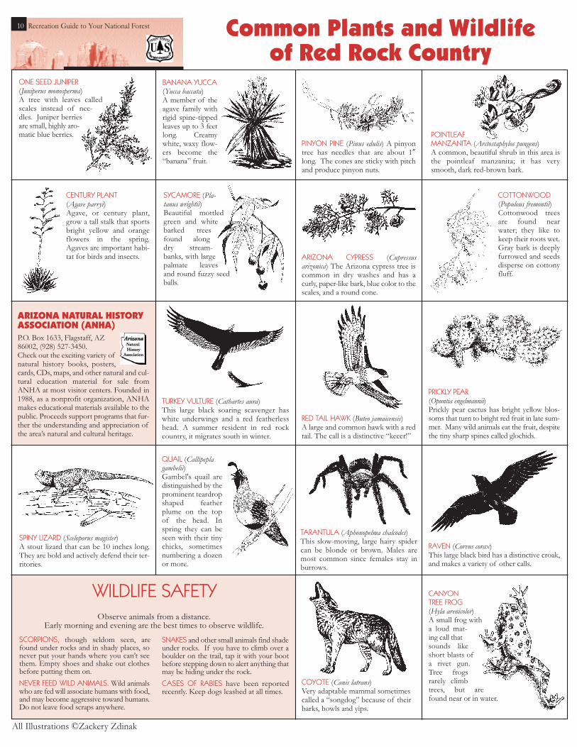
COYOTE (Canis latrans)Very adaptable mammal sometimescalled a “songdog” because of theirbarks, howls and yips.
ARIZONA CYPRESS (Cupressus arizonica) The Arizona cypress tree iscommon in dry washes and has acurly, paper-like bark, blue color to thescales, and a round cone.
SPINY LIZARD (Sceloporus magister)A stout lizard that can be 10 inches long.They are bold and actively defend their ter-ritories.
CANYONTREE FROG(Hyla arenicolor)A small frog witha loud mat-ing call thatsounds likeshort blasts ofa rivet gun.Tree frogsrarely climbtrees, but arefound near or in water.
RAVEN (Corvus corax)This large black bird has a distinctive croak,and makes a variety of other calls.
TARANTULA (Aphonopelma chalcodes)This slow-moving, large hairy spidercan be blonde or brown. Males aremost common since females stay inburrows.
PINYON PINE (Pinus edulis) A pinyontree has needles that are about 1”long. The cones are sticky with pitchand produce pinyon nuts.
CENTURY PLANT(Agave parryi) Agave, or century plant,grow a tall stalk that sportsbright yellow and orangeflowers in the spring.Agaves are important habi-tat for birds and insects.
TURKEY VULTURE (Cathartes aura)This large black soaring scavenger haswhite underwings and a red featherlesshead. A summer resident in red rockcountry, it migrates south in winter.
ONE SEED JUNIPER(Juniperus monosperma) A tree with leaves calledscales instead of nee-dles. Juniper berriesare small, highly aro-matic blue berries.
BANANA YUCCA(Yucca baccata)A member of theagave family withrigid spine-tippedleaves up to 3 feetlong. Creamywhite, waxy flow-ers become the“banana” fruit.
PRICKLY PEAR(Opuntia engelmannii) Prickly pear cactus has bright yellow blos-soms that turn to bright red fruit in late sum-mer. Many wild animals eat the fruit, despitethe tiny sharp spines called glochids.
Observe animals from a distance.Early morning and evening are the best times to observe wildlife.
COTTONWOOD(Populous fremontii)Cottonwood treesare found nearwater; they like tokeep their roots wet.Gray bark is deeplyfurrowed and seedsdisperse on cottonyfluff.
RED TAIL HAWK (Buteo jamaicensis)A large and common hawk with a redtail. The call is a distinctive “keeer!”
SYCAMORE (Pla-tanus wrightii)Beautiful mottledgreen and whitebarked treesfound alongdry stream-banks, with largepalmate leavesand round fuzzy seedballs.
POINTLEAF MANZANITA (Arctostaphylos pungens) A common, beautiful shrub in this area isthe pointleaf manzanita; it has verysmooth, dark red-brown bark.
SCORPIONS, though seldom seen, arefound under rocks and in shady places, sonever put your hands where you can’t seethem. Empty shoes and shake out clothesbefore putting them on. NEVER FEED WILD ANIMALS. Wild animalswho are fed will associate humans with food,and may become aggressive toward humans.Do not leave food scraps anywhere.
SNAKES and other small animals find shadeunder rocks. If you have to climb over aboulder on the trail, tap it with your bootbefore stepping down to alert anything thatmay be hiding under the rock.CASES OF RABIES have been reportedrecently. Keep dogs leashed at all times.
WILDLIFE SAFETY
All Illustrations ©Zackery Zdinak
Common Plants and Wildlife of Red Rock Country
QUAIL (Callipeplagambelii) Gambel's quail aredistinguished by theprominent teardropshaped featherplume on the topof the head. Inspring they can beseen with their tinychicks, sometimesnumbering a dozenor more.
ARIZONA NATURAL HISTORYASSOCIATION (ANHA)P.O. Box 1633, Flagstaff, AZ86002, (928) 527-3450.Check out the exciting variety ofnatural history books, posters,cards, CDs, maps, and other natural and cul-tural education material for sale fromANHA at most visitor centers. Founded in1988, as a nonprofit organization, ANHAmakes educational materials available to thepublic. Proceeds support programs that fur-ther the understanding and appreciation ofthe area’s natural and cultural heritage.

Recreation Guide to Your National Forest 11
BIOLOGICAL SOIL CRUSTSStop! Don’t step on thatsoil. It’s full of life.
Although the soil surface may look like dirt to you,it is full of living organisms that are a vital part ofthe desert ecosystem. This veneer of life is called
a biological soil crust. These crusts are found throughoutthe world, from hot deserts to polar regions. Crusts gen-erally cover all soil spaces not occupied by green plants.In many areas, they comprise over 70 percent of the liv-ing ground cover and are key in reducing erosion,increasing water retention, and increasing soil fertility. Inmost dry regions, these crusts are dominated bycyanobacteria (previously called blue-green algae), whichare one of the oldest known life forms. Soil crusts alsoinclude lichens, mosses, microfungi, bacteria, and greenalgae.
These living organisms and their byproducts create acontinuous crust on the soil surface. Immature crusts aregenerally flat and the color of the soil, which makes themdifficult to distinguish from bare ground. Mature crusts,in contrast, are usually bumpy and dark colored due tothe presence of lichens, mosses, and high densities ofcyanobacteria and other organisms.
The crusts are important in the interception of rainfall,absorbing up to 10 times their volume of water. Theroughened surface of the crusts slows runoff andincreases water infiltration into the soil, which is espe-cially important in arid areas with sporadic, heavy rainfall.In addition to stabilizing surfaces and increasing waterharvesting, crustal organisms also contribute nitrogenand organic matter to ecosystems, especially importantin desert ecosystems where nitrogen levels are low andoften limit productivity.
Unfortunately the crusts are not a match for the stresscaused by footprints or bike and car tires. Even smallimpacts can have profound consequences. Crushedcrusts contribute less nitrogen and organic matter to theecosystem and the soils are left highly susceptible to bothwind and water erosion. Blowing sediment from dis-turbed areas can cover nearby healthy crusts. Burial canmean death because crustal organisms need sunlight tolive.
A single footprint has a long lasting effect on desertecosystems: nitrogen fixation stops and underlying soilconnections are broken. Under good conditions, a thinveneer of cyanobacteria may return in 5 years. Recoverymay take up to 20 years in places with higher rainfall andup to 250 years in places of lower rainfall (red rock coun-try).
Thousands visit Cathedral Rock each year. Please stay on designated trails.
© Wayne Ranney from Sedona Through Time
Some 4 million people visit Red Rock Countryannually, a large number considering that one ofthe prime attractions is rust! Many visitors ask
why the red rocks are red. The answer is that the redcolor found in most of the layers is hematite, or ironoxide, a mineral found in great abundance in sedimen-tary rocks.
Rocks in Red Rock Country are old. From bottomto top layer, one can observe about 80 million yearsof sediment deposition! Picture a giant layer cake,each layer being its own type of rock (sandstone,limestone, siltstone). Each layer was deposited in itsown geologic era. Some layers were deposited inshallow seas, some in river deltas and flood plains.Some layers are hardened sand dunes. All of thesestrata (except the basalt) were laid down, one atopanother, during the Paleozoic Era. During this era,fishes dominated the oceans and plants and amphib-ians were just starting to live on land. T. Rex had noteven evolved yet! Amazingly, these rocks haven’teroded away even though wind and water have beenworking on them for 275 million years.
Solving the Mystery ofthe Red Rocks
Vortex Sites are Popular
ANorthern Arizona University study found that 64percent of visitors in a recent year came to RedRock Country seeking some kind of spiritual expe-
rience. Part of the attraction is the inspirational andregenerative nature of Sedona’s scenic beauty, as well asa recreation destination.
Sedona is believed by some to be a vortex meditationsite, places of power in the red rocks that enhance prayer,contemplation, and reflection for people of all faiths.Most Sedona bookstores have books on vortex beliefsand methods for experiencing these aspects of spiritualexploration. Vortex sites are some of the most visitedand impacted sites on the national forest.
It is important to protect the spiritual beauty of this land-scape. Here’s how you can help: • Treat the site and the trails to it as a fragile resource –
Leave No Trace. • Do not move rocks and sticks to create “medicine
wheels.” For many, this detracts from the area’s naturalbeauty and leaves an impact on the site.
• Stay on the main trail to the site. Do not create side trails. • When you depart, leave nothing behind – take with you
only memories and wisdom. • Preserve the natural quiet by chanting, drumming,
singing, or praying quietly.
Because thousands visit these sites every year, each of usmust help to keep the beauty of Sedona’s inspirationallandscape safe for many generations to come.
The large, black patches of dark, knobby, brittlecrust are actually a cryptobiotic crust. Thecrust is made of lichen, moss, cyanobacteria,
liverwort and fungi. The crust prevents erosionand retains water and minerals for plants. Withoutthe cryptobiotic crust, the red rock landscapewould become barren sand dunes. The crust is eas-ily broken, especially when it is dry. A single foot-step can erase decades of growth.
DON’T BUSTTHE CRUST
It’s Alive
Stay On TheTrail
Typical Red Rock Country geologic cross section
What can you do to preserve a healthy desert ecosystem?
Where trails do not exist, hike in washes or on rocks.Text excerpted from USGS Fact Sheet FS-065-01, July 2002, Reprinted April 2004.
Learn more at www.soilcrust.org

12 Recreation Guide to Your National Forestmillion acres has been designated as wilderness, or 4.5million acres. One third of Red Rock Country is in threeFederally designated wilderness areas, totaling more than140,000 acres:
• Red Rock-Secret Mountain Wilderness• Sycamore Canyon Wilderness• Munds Mountain Wilderness
Colorful cliffs, soaring pinnacles, cactus, thick pinyon-ju-niper forests, and rich riparian areas flanked by crimsonwalls distinguish these special places. Black bear, mountainlion, white-tailed deer, rattlesnakes and canyon wrens arecommon to these wilderness areas. These species andmany others depend on natural habitat where man is anoccasional visitor.
Red Rock Country’s wildernesses are literallyin Sedona’s backyard. Most of the cliffsviewed from town and many of the trailsaround Sedona are in the Munds Mountain
and Red Rock-Secret Mountain Wildernessareas. Bell Rock is in wilderness, only steps from
the highway. These wildernesses are some of themost heavily visited in the Nation with over
130,000 visitors each year. Wilderness qualities of soli-tude, silence, and a pristine environment are no longerfound in some popular areas. Even so, protecting RedRock Country’s fragile wilderness areas from further
impact depends on you. Using these areas with thecare and respect they deserve, will ensure
these fragile lands remain wild.
Prehistoric Indian cliff dwellings in Red Rock Countryoffer vivid evidence of habitation at least 1500 yearsago. According to archaeologists, the Sinagua
(meaning “without water”) culture flourished in theVerde Valley from around 600 AD to 1400. Where didthey go? This mystery has never been solved. For rea-sons still unknown, the last Sinagua disappeared from thearchaeological record around AD 1425. Not long after-wards, the area became the home of the Yavapai people,and then later the Apache, whose descendents live heretoday.
Rock art is one of the legacies left behind by the Sinagua.Petroglyphs, stone carvings, and pictographs, figures andsymbols painted on sandstone walls are found on rockpanels throughout Red Rock Country. The true meaningof the rock art is unknown, but various theories exist. Therock art could be clan signs, spiritual messages, calendars,or hunting stories.
SITES OPEN TO THE PUBLIC:Montezuma Castle National Monument – Cliff dwelling by Wet Beaver Creek. Open 8 a.m. –7 p.m. Memorial Day-Labor Day; Winter hours (afterLabor Day) are 8 a.m. to 5 p.m. Take I-17 to Exit 289.Go past Cliff Castle Casino and turn north at sign. Fee.928-567-3322
Montezuma Well National Monument – Limestone sink-hole, cliff dwellings, and lush oasis by Wet Beaver Creek.Take McGuireville/Rimrock Exit on I-17. Follow signs tomonument. Open 8-7, Memorial Day-Labor Day; Winterhours (after Labor Day) are 8 a.m. to 5 p.m. Free. 928-567-3322
Tuzigoot National Monument – Partially restored Indianpueblo and museum. Located in Cottonwood. Open 8a.m. – 5 p.m. daily. Entrance fee. 928-634-5564
Walnut Canyon National Monument – Narrow, deeplimestone canyon holds more than 80 cliff dwellings. Pic-nic areas, trails, and visitor center. Open 8 a.m. –5 p.m. daily. Go 9 miles east of Flagstaff on I-40, Exit204. $5 entrance fee. 928-526-3367
Wupatki National Monument - Rock art, ruins, andscenery. Open 8 a.m. – 5 p.m. daily. North of Flagstaffon Hwy. 89A. $3 entrance fee. 928-679-2365
V-V Cultural Site – Rock art site and visitor center on thebanks of Wet Beaver Creek. Open 9:30 a.m. – 3:30 p.m.,Fri., Sat., Sun., and Mon. only. From Sedona exit (298) offI-17, take Forest Road 618 east and follow signs for 3 milesto entrance gate. No pets. Red Rock Pass required. Groupsover 14 people must have reservations. 928-282-3854.
Palatki Cultural Site – Cliff dwelling, rock art, and visitor cen-ter. Open 9:30 a.m. – 3:30 p.m. daily. Reservation required– call 928-282-3854. Take Highway 89A 9 miles southwestof the intersection with Hwy. 17, to Forest Road 525. Followsigns north for 6 miles. Take Forest Road 795 for 1.5 milesto entrance gate. No pets. Red Rock Pass required.
Honanki - Cliff dwelling and rock art. Open 10 a.m. – 6p.m. daily. Take Hwy. 89A southwest of Sedona to ForestRoad 525. Follow signs north for about 10 miles (unpaved)on Forest Road 525. High-clearance vehicle recommended.Red Rock Pass required. 928-282-4119
Museum of Northern Arizona – Indian culture museum, gift shop, exhibits, nature trail, art collection.Two miles north of Flagstaff on Highway 180. Fee.928-774-5213
Sedona Heritage Museum – Highlights the history ofSedona, its pioneers and settlers. Historic buildings, trails andviews. Located in uptown Sedona at 735 Jordan Road. Fee.928-282-7038 www.sedonamuseum.org
Fort Verde State Historic Park – Located in Camp Verde,this was a major fort for General George Crook duringthe Indian campaigns of the 1870s. Fee. Open 8 a.m. to5 p.m. daily except Christmas. (928) 567-3275.
Collecting orrelocatingarchaeologi-cal artifacts isunlawful.
Verde Valley’s Historyand Culture Lives
Defacing ordestroying natural featuresor archaeologi-cal sites is
Sitting, walking,pushing orclimbing on ruinwalls is unlaw-
Recreation Guide to Your National Forest
Address any comments or questions about thispublication to the Coconino National ForestRed Rock Ranger District at 928-282-4119.
Design: Douglas Smith Design, Chris WilliamsonPhotography: Copyright ©Tom Johnson except asnotedCover Illustration: Raven © 1999 Zachery ZdinakSupported by: The Friends of the Forest, City ofSedona, Arizona Natural History Association,Sedona-Oak Creek Canyon Chamber of Commerce.
The Friends of theForest, Inc. P.O. Box 2391 Sedona, AZ 86339
City of Sedona 102 Roadrunner DriveSedona, AZ 86336 (928) 282-3113
Arizona Natural History Association P.O. Box 1633 Flagstaff, AZ 86002 (928) 527-3450
Sedona-Oak Creek CanyonChamber of Commerce P.O. Box 478 Sedona, AZ 86336 (928) 282-7722
Wilderness . . . Sedona’sWild Backyard “Our wild lands are our most important endangered species.”—Former Wisconsin Senator Gaylord Nelson
John Muir wrote, “wilderness is thehope of the world.” Wildernesshas traditionally served as a
romantic metaphor for the Americanspirit. In 1964, the U.S. Congresspassed the Wilderness Act, settingaside 91.2 million acres of nationalforests to remain in their naturalstate. Unlike other Federal publiclands, areas designated “wilderness”are protected forever from both developmentand motor vehicles.
Over half of all American wilderness isin Alaska, where 56.5 million acres havebeen set aside as wilderness.About 6 percent of Arizona’s 72
Don't bust the crust
Sketch by Susan Kliew-
The Archaeological Resources Protection Act of 1979protects cultural resources for the benefit of all.Admire these sites, learn from them, but leave every-thing where it is. To do otherwise is not only disre-spectful, it is against the law.