RECORD OF PLAN CONFORMANCE AND CATEGORICAL EXCLUSION … · RECORD OF PLAN CONFORMANCE AND...
6
RECORD OF PLAN CONFORMANCE AND CATEGORICAL EXCLUSION (CX) DETERMINATION CX Log #: DOI-BLM-ORV040-2014-037-CX CE Exemption category: 516 DM 11.9, E. 13: Amendments to existing rights-of-way, such as upgrading of existing facilities, which entail no additional disturbances outside the right-of-way boundary. BLM Office: Vale District Bureau of Land Management, 100 Oregon Street, Vale, Oregon 97918 Phone #: 541-473-3144 BACKGROUND: Project Name: Assignment of existing right-of-way OR-55423 Applicant: The Catfish Junction, LLC. Owner David G. Shira Location of Proposed Action: T. 15S, R. 46E, Section: 18 DESCRIPTION OF THE PROPOSED ACTION: On October 22, 2013, The Catfish Junction, LLC submitted an application (SF-299) requesting an assignment of an existing right-of-way. The assignment would include a name change and an adjustment to the acreage to reflect the current status on the ground. The improvements are already in place. The increase in acreage is to include a grassy area that is utilized for tent camping at the facility. The additional area does not exceed the current acreage that is authorized at 1.0 acre. PLAN CONFORMANCE All actions approved or authorized by the BLM must conform to the existing land use plan where one exists (43 CFR 1610.5-3, 516 DM 11.9). Although it is not a NEPA requirement, the BLM includes within all its NEPA documents a statement about the conformance of the proposed action and alternatives with the existing land use plan. The BLM's planning regulations state that the term "conformity" or "conformance" means that "... a resource management action shall be specifically provided for in the plan, or if not specifically mentioned, shall be clearly consistent with the terms, conditions, and decisions of the approved plan or amendment" (43 CFR 1601.0-5(b)). The proposed action is also in conformance with the management objectives of the Southeastern Oregon Resource Management Plan (SEORMP, Sept. 2002), General Planning Criteria, cited on page 9 of the RMP. The proposed action conforms to program-specific objectives of the SEORMP which are cited on page 108 - 111. This project will require no new or additional construction. It is an amendment to an existing right of way to reflect the current situation on the ground. Exclusion areas are: wilderness areas and wild river segments. Avoidance areas are Wilderness Study Areas, ACEC's and scenic and recreation river segments. DOCUMENTATION OF CATEGORICAL EXCLUSIONS: EXTRAORDINARY CIRCUMSTANCES This categorical exclusion is appropriate in this situation because there are no extraordinary circumstances potentially having effects that may significantly affect the environment. The proposed action has been reviewed and none of the circumstances described in 516 DM 2, Appendix 2, and listed below apply. Page 2 of 4
Transcript of RECORD OF PLAN CONFORMANCE AND CATEGORICAL EXCLUSION … · RECORD OF PLAN CONFORMANCE AND...

RECORD OF PLAN CONFORMANCE AND CATEGORICAL EXCLUSION (CX) DETERMINATION
CX Log #: DOI-BLM-ORV040-2014-037-CX CE Exemption category: 516 DM 11.9, E. 13: Amendments to existing rights-of-way, such as upgrading of existing facilities, which entail no additional disturbances outside the right-of-way boundary.
BLM Office: Vale District Bureau of Land Management, 100 Oregon Street, Vale, Oregon 97918 Phone #: 541-473-3144
BACKGROUND: Project Name: Assignment of existing right-of-way OR-55423 Applicant: The Catfish Junction, LLC. Owner David G. Shira Location of Proposed Action: T. 15S, R. 46E, Section: 18
DESCRIPTION OF THE PROPOSED ACTION: On October 22, 2013, The Catfish Junction, LLC submitted an application (SF-299) requesting an assignment of an existing right-of-way. The assignment would include a name change and an adjustment to the acreage to reflect the current status on the ground. The improvements are already in place. The increase in acreage is to include a grassy area that is utilized for tent camping at the facility. The additional area does not exceed the current acreage that is authorized at 1.0 acre.
PLAN CONFORMANCE All actions approved or authorized by the BLM must conform to the existing land use plan where one exists (43 CFR 1610.5-3, 516 DM 11.9). Although it is not a NEPA requirement, the BLM includes within all its NEPA documents a statement about the conformance of the proposed action and alternatives with the existing land use plan. The BLM's planning regulations state that the term "conformity" or "conformance" means that "... a resource management action shall be specifically provided for in the plan, or if not specifically mentioned, shall be clearly consistent with the terms, conditions, and decisions of the approved plan or amendment" (43 CFR 1601.0-5(b)).
The proposed action is also in conformance with the management objectives of the Southeastern Oregon Resource Management Plan (SEORMP, Sept. 2002), General Planning Criteria, cited on page 9 of the RMP. The proposed action conforms to program-specific objectives of the SEORMP which are cited on page 108 - 111. This project will require no new or additional construction. It is an amendment to an existing right of way to reflect the current situation on the ground. Exclusion areas are: wilderness areas and wild river segments. Avoidance areas are Wilderness Study Areas, ACEC's and scenic and recreation river segments.
DOCUMENTATION OF CATEGORICAL EXCLUSIONS: EXTRAORDINARY CIRCUMSTANCES This categorical exclusion is appropriate in this situation because there are no extraordinary circumstances potentially having effects that may significantly affect the environment. The proposed action has been reviewed and none of the circumstances described in 516 DM 2, Appendix 2, and listed below apply.
Page 2 of 4

Yes No Extraordinary Circumstances Initials Date
'1.Have significant impacts on public health or safety. 2.Have significant impacts on such natural resources and unique geographic characteristics as historic or cultural resources; park, recreation or refuge lands; wilderness areas; wild or scenic rivers; national natural landmarks; sole or principal drinking water aquifers; prime farmlands; wetlands (Executive Order 11990); floodplains (Executive Order 11988); national monuments; migratory birds; and /other ecologically significant or critical areas. 3.Have highly controversial environmental effects or involve unresolved conflicts concerning alternative uses of
- available resources [NEPA Section 102(2)(E)J. 4.Have highly uncertain and potentially significant environmental effects or involve unique or unknown
,X environmental risks. 5.Establish a precedent for future action or represent a decision in principle about future actions with potentially
- significant environmental effects. 6.Have a direct relationship to other actions with individually insignificant but cumulatively significant
-environmental effects. X 7.Have significant impacts on properties listed, or eligible CB 4/30/2014
for listing, on the National Register of Historic Places as determined by either the bureau or office.
X 8.Have significant impacts on species listed, or proposed SF (plants) 4.2.14 to be listed, on the List of Endangered or Threatened MM (wildlife) 4.3.14 Species, or have significant impacts on designated Critical Habitat for these species. 9.Violate a Federal law, or a State, local, or Tribal law or
&/>< requirement imposed for the protection of the environment. —/ /1'1
Have a disproportionately high and adverse effect on low income or minority populations (Executive Order 5/3,4/10.
Limit access to and ceremonial use of Indian sacred 4/30/2014 sites on Federal lands by Indian religious practitioners or significantly adversely affect the physical integrity of such sacred sites (Executive Order 13007).
X 11. CB
Contribute to the introduction, continued existence, or
X spread of noxious weeds or non-native invasive species Is 3/25/2014 known to occur in the area or actions that may promote the introduction, growth, or expansion of the range of such species (Federal Noxious Weed Control Act and Executive Order 13112).
12.
Page 3 of

DOCUMENTATION OF RECOMMENDED MITIGATION For any item(s) above checked "Yes", proposed mitigating measures for those items are listed below. If the extraordinary circumstances cannot be mitigated, the criteria required for a CE are not met and BLM must prepare an EA or EIS.
Item Can Be Cannot Be No. Miti lated Mitigated Mitigation Measures Reviewer Date
SUMMARY OF FINDINGS AND DETERMINATION The proposed action is categorically excluded from further documentation under the National Environmental Policy Act (NEPA) in accordance with the Departmental Manual Categorical Exclusions list, sections of which are cited and quoted above. The proposed action has also been reviewed in relation to the above listed 12 Extraordinary Circumstances in accordance with the Departmental Manual, and none of these circumstances apply.
DECISION RECORD Based on the enclosed Categorical Exclusion Documentation, DOI-BLM-ORV040-2014-037-CX, I have determined that the proposed action to authorize the assignment and renew the existing right-ofway authorized as OR-55423 involves no significant impacts to the human environment and requires no further environmental analysis. It is my decision to authorize this action as proposed. For additional information concerning this project, contact Project Lead Trisha Skerjanec, Vale District Office, 100
regon Street, Vale, Oregon 97918. Phone (541) 473-3144.
alty Specialist Prepared By: Title qte141/4
eviewed By: Title Date
y
Page 4 of 4

Exhibit A May 2014
a. The holder shall conduct all activities associated with the maintenance, operation, and termination of the right-of-way within the authorized limits of the right-of-way. Any relocation, additional construction, or use that is not in accordance with the approved plan(s) of development shall not be initiated without the prior written approval of the authorized officer. Noncompliance with the above will be grounds for an immediate temporary suspension of activities if they constitute a threat to public health and safety or the environment.
b. The holder shall recontour disturbed areas, or designed sections of the right-of-way, to restore the site to approximately the original contour of the ground as determined by the authorized officer.
C.�Any cultural and/or paleontological resource (historic or prehistoric site or object, or fossil) discovered by the holder, or any persons working on his behalf on public or Federal land shall be immediately reported to the authorized officer. Holder shall suspend all operations in the immediate area of such discovery until written authorization to proceed is issued by the authorized officer. An evaluation of the discovery will be made by the authorized officer to determine appropriate actions to prevent the loss of significant cultural or scientific values. The holder will be responsible for the cost of evaluation and mitigation, and any decision as to proper avoidance, protection or mitigation measures will be made by the authorized officer after consulting with the holder and others under Section 106 of the National Historic Preservation Act.
d. Pursuant to 43 CFR 10.4(g), the holder of this authorization must immediately notify the authorized officer, by telephone, with written confirmation, immediately upon the discovery of human remains, funerary items, sacred objects, or objects of cultural patrimony. Further, pursuant to 43 CFR 10.4 (c) and (d), the holder must stop activities in the vicinity of the discovery and protect it for 30 days or until notified to proceed by the authorized officer. The BLM Authorized Officer will determine avoidance, protection or mitigation measures in consultation with the Holder, Oregon SHPO, and affected Tribes. Costs associated with the discovery, evaluation, protection or mitigation of the discovery shall be the responsibility of the holder.
e. Use of pesticides shall comply with the applicable Federal and State laws. Pesticides shall be used only in accordance with their registered uses and within limitations imposed by the Secretary of the Interior. Prior to the use of pesticides, the holder shall obtain from the Authorized Officer, written approval of a plan showing the type and quantity of material to be used, pest(s) to be controlled, method of application, location of storage and disposal of containers, and any other information deemed necessary by the Authorized Officer. Emergency use of pesticides shall be approved in writing by the Authorized Officer prior to such use.
f. The holder shall be responsible for weed control on disturbed areas within the limits of the right-of-way. The holder is responsible for consultation and coordination with the BLM Weed Coordinator and/or local authorities for acceptable weed control methods and products prior to implementing weed treatments. Use of all herbicides shall comply with applicable Federal and State laws and the Label.

g. The holder of this right-of-way grant or the holder's successor in interest shall comply with Title VI of the Civil Rights Act of 1964 (42 U.S.C. 2000d et seq.) and the regulations of the Sôcretary of the Interior issued pursuant thereto.
h. The holder agrees to indemnify the United States against any liability arising from the release of any hazardous substance or hazardous waste (as these terms are defined in the Comprehensive Environmental Response, Compensation and Liability Act of 1980, (43 U.S.C. 9601, et seq. or the Resource Conservation and Recovery Act of 1976, 42 U.S.C. 6901, et seq.) on the right-of-way (unless the release or threatened release is wholly unrelated to the right-of-way holder's activity on the right-of-way). This agreement applies without regard to whether a release is caused by the holder, its agent, or unrelated third parties.
i. The holder shall protect all survey monuments found within the right-of-way. Survey monuments include, but are not limited to, General Land Office and Bureau of Land Management Cadastral Survey Corners, reference corners, witness points, U.S. Coastal and Geodetic benchmarks and triangulation stations, military control monuments, and recognizable civil (both public and private) survey monuments. In the event of obliteration or disturbance of any of the above, the holder shall immediately report the incident, in writing, to the authorized officer and the respective installing authority if known. Where General Land Office or Bureau of Land Management right-of-way monuments or references are obliterated during operations, the holder shall secure the services of a registered land surveyor or a Bureau cadastral surveyor to restore the disturbed monuments and references using surveying procedures found in the Manual of Surveying Instructions of the Survey of the Public Lands of the Unites States, latest edition. The holder shall record such survey in the appropriate county and send a copy to the authorized officer. If the Bureau cadastral surveyors or other Federal surveyors are used to restore the disturbed survey monument, the holder shall be responsible for the survey cost.
Ninety days prior to termination of the right-of-way, the holder shall contact the authorized officer to arrange a joint inspection of the right-of-way. This inspection will be held to agree to an acceptable termination (and rehabilitation) plan. This plan shall include, but is not limited to, removal of facilities, drainage structures, or surface material, recontouring, topsoiling, or seeding. The authorized officer must approve the plan in writing prior to the holder's commencement of any termination activities.
The holder shall allow use of the boat ramp at no charge to representatives of federal, state and local governments performing official duties.
k.�
To minimize erosion, no fill material or native vegetation should be removed from the river bank or riparian area.
1.�
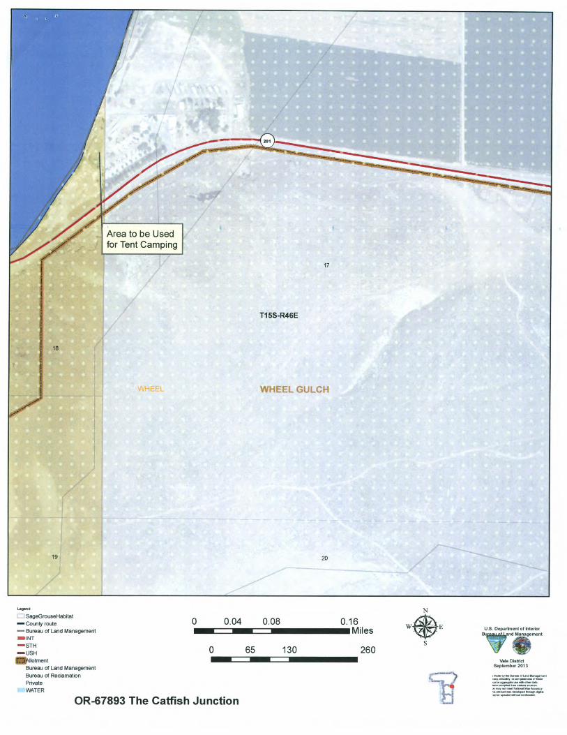
Legetid
SageGrouseHabitat
County route 0�0.04�0.08 0.16 us Department of InteriorBureau of Land Management Miles— —
,and ManagementINT
STH 0�65�130 260—usF-t Z.
Allotment Vale District September 2013Bureau of Land Management
Bureau of Reclamation Private
WATER
OR-67893 The Catfish Junction