RECONNECTING HERITAGE: PEDESTRIAN AND BICYCLE...
38
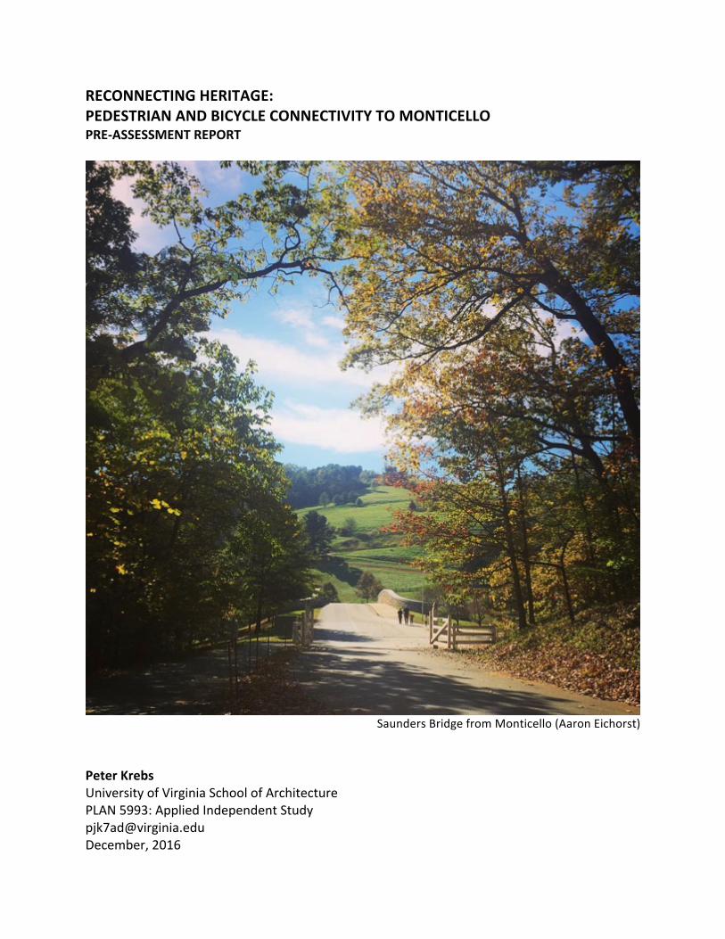
RECONNECTING HERITAGE: PEDESTRIAN AND BICYCLE CONNECTIVITY TO MONTICELLO PRE-ASSESSMENT REPORT Saunders Bridge from Monticello (Aaron Eichorst) Peter Krebs University of Virginia School of Architecture PLAN 5993: Applied Independent Study [email protected] December, 2016
Transcript of RECONNECTING HERITAGE: PEDESTRIAN AND BICYCLE...
RECONNECTINGHERITAGE:PEDESTRIANANDBICYCLECONNECTIVITYTOMONTICELLOPRE-ASSESSMENTREPORT
SaundersBridgefromMonticello(AaronEichorst)
PeterKrebsUniversityofVirginiaSchoolofArchitecturePLAN5993:[email protected],2016
2
CONTENTS
EXECUTIVESUMMARY 3
I.INTRODUCTION 6
II.HISTORICALBACKGROUND 11
III.CURRENTCONDITIONS 14
IV.INSTITUTIONALSTAKEHOLDERS 25
V.ISSUES/OPPORTUNITIES 28
VI.RECOMMENDEDPLANNINGAPPROACH 32
SOURCES 36
APPENDICIES
APPENDIXA:PRACTICUMPROJECTPROPOSAL 39
APPENDIXB:STAKEHOLDERCONTACTS 42
APPENDIXC:STAKEHOLDERINTERVIEWLOG 44
APPENDIXD:PLANNINGPROFESSIONCONTEXT,LOGICMODELANDTHEORYOFCHANGE 45
APPENDIXE:ESSAY—OVERCOMINGTHEOBDURACYOFTHESTATUSQUO 49ACKNOWLEDGEMENTSThis reportdescribesa collaborativeprocessand is itself theworkofmanyminds.All of thestakeholderslistedinthedocumentgenerouslysharedtheirtimeandexpertise.Severalofthemprovidedmultipleroundsofadviceandfeedback.Ialsowouldliketothanktheentirefacultyofthe UVa Urban and Environmental Planning department—several of whom mentored theproject—andespeciallymyadvisorAndrewMondschein.
3
EXECUTIVESUMMARYMonticello is an important source of Charlottesville’s history, cultural identity and economic
vitality. In combinationwith theAcademicalVillage at theUniversityofVirginia it is anearly
unmatchedresourceandveryunusualforatownofthissize.Monticelloisclosetothecity(its
landsarelessthanamilefromtheborder)anditisvisiblefrommanylocations,yetitisdifficult
andpotentiallydangeroustogettherewithoutacar.Thisdiscontinuityposesproblemsofequity
andunrealizedopportunityforMonticello,thecityandtheregion.
Monticellowas once easily accessible. Thereweremultiple routes into townwith significant
travelandexchangeinbothdirections.WhenInterstate64wasbuilt(inthe1960’sand70’s)all
ofthoserouteswereseveredexceptforone(VA-20)andthatwaswidenedforhighwayspeeds
withoutaccommodationforbicyclesorpedestrians,effectivelycuttingMonticelloofffromthose
whodonothave—orchoosetouse—acar.1Thereisnotransitconnection,whichlimitsresidents
andvisitorsalike.
The Thomas Jefferson Foundation, which owns and operates Monticello and much of the
surroundinglands,bridgedhalfthedistancein1998byopeningSaundersMonticelloTrail.This
windingtwo-milepathway is fullyADAaccessible(whileclimbingamountain!)and itsbeauty
attractstremendouslydiversevisitorship.Combinedwiththe600adjoiningacresofparkland,it
isawildlysuccessfullandscapeandadestinationinitsownrightyetitisdifficulttogettherewith
avehicleandnearlyimpossiblewithoutone.
The remaining gap, subject of this study, is small but complicated. The highway itself is a
formidable physical and psychological barrier.2 The zone is split between two jurisdictions
(CharlottesvilleandAlbemarleCounty)withathird(VirginiaDepartmentofTransportation) in
1ThatsegmentispartofNationalBikeRoute76,notwithstandingitsunsuitability.2Itheorizeanexusbetweenthesethreeforces—physical,psychologicalandprocedural—thatcausesthemtomutuallyself-reinforcetomakesimpleproblemsmorechallenging.SeeAppendixE.
4
between.Therearemultipleinstitutionallandownersaswell,mostofwhomwouldliketosolve
theproblembutnoneabletotackleitalone.Acollaborativeprocesswillberequired.
BoththeCityandCounty’sComprehensivePlansmentionMonticelloconnectivityorshowiton
theirmapsbuttheyarenotcoordinated.Additionally,Morvenhasbegunastudyforatrailfrom
its vast andhistorically significant lands southof town, through JamesMonroe’sHighland to
Monticello.3TheregionalThomasJeffersonPlanningDistrictCommission(TJPDC)hasbeguna
decennialrevisionofits2004JeffersonAreaBikeandPedestrianPlanandthissegmentwillbea
crucial part of it. As part of that process, the TJPDC is sponsoring a spring study byMasters
students(includingmyself)fromUniversityofVirginia’sdepartmentofUrbanandEnvironmental
Planning.Wewillprovideresearchsupport.
This document provides background for theMonticello Connectivity portion of thatwork by
identifyingkeystakeholdersandissues,andexaminingtheoverlappingspatial factorssuchas
jurisdiction, land tenure and legacy infrastructure that make this problem complicated. It
evaluatesthecurrentplanningenvironmenttodeterminewhetheracollaborativeapproachis
likelytosucceed.
Herearesomekeyfindings,severalofwhichwillbeinvestigationtopicsforthepracticumgroup:4
• The key stakeholders are motivated and ready to work together but they need
coordination.Theyhavegoodbutmostlyinformalworkingrelationships.
• Multi-jurisdictionalplanintegrationisnotthelocalnorm,butthatmightbechanging.
• TheTJPDCdecennialprocesswillprovidecoordinationandyieldrecommendationsbutit
isnotadvocacy.Stakeholderswillneedimplementationstrategiesandfunding.
• Tobesuccessful,thisprojectneedstopayattentiontotheregionalcontextandlookat
opportunitiesnear(butoutsideof)thestudyarea,suchasPiedmontVirginiaCommunity
3TheUniversityofVirginiaFoundationownsMorvenasitdoestheBlueRidgeSanitariumsite,whichoccupiesmuchofthelandbetweenCharlottesvilleandtheSaundersTrail.
4Fullissue/opportunitylistonpage28;SuccessfulPracticumproposalinAnnexA.
5
College and the County’s Southern Neighborhood area. It is not only about trips to
MonticellofromCharlottesville.
• ThenotionthatthetrailcouldextendallthewaytoMorven,andconnectHighland, is
extraordinarilycompellingandappearswithinreach.
• TheissueofconnectivityandaccessibilitytoMonticello(andtheothersites)isnotonlya
physical question. It has an important socio-historical component, which the Thomas
JeffersonFoundationisactivelyengaging.Thistrailwouldthereforenotatypicalpieceof
infrastructure:itwouldbeaphysicalexpressionofhistoricalandculturaldiscovery.That
history is being energetically debated, contested and expanded. The trailwill have to
acknowledgeandreflectthat.
• Thelandscapeinquestionisquitebeautiful,withmanyopportunitiesforrecreationand
education.
• The entire pathway from Morven to the UVa Rotunda (and beyond) via Highland,
Monticello,theSaundersTrail,Belmont,theDowntownMall,theJeffersonSchooland
West Main carries nearly infinite possibilities for interpretation, programming and
storytelling.
• Planninghistoryandtheoryrecommendscircumspection:eventhoughthisprojectseems
very beneficial, there could be hidden downsides, such as residential or business
displacement.Thereisnospecificevidencethatthisislikely,butitisseriousenoughto
meritinvestigation.
Thiswillnotbeatypicalamenityorrecreationaltrail.Itisaconnectionbetweentwohalvesofa
UNESCOWorldHeritagesite;aregionandthefulltellingofitshistory;acommunityandavast
zone of ecological and cultural discovery. There are challenges but very high and very likely
rewards.It isanexcitingprojectandanopportunitytomodelabettercollaborativeapproach
betweenneighboringlocalities,governmentsandfoundationstounlockasharedopportunity.
Thesituationisripeforacollaborativemasterplanningprocesstoproceed.
6
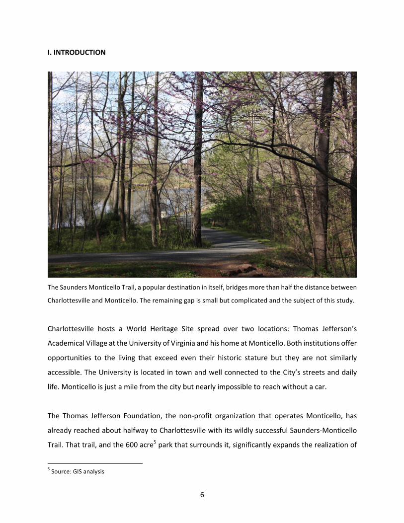
I.INTRODUCTION
TheSaundersMonticelloTrail,apopulardestinationinitself,bridgesmorethanhalfthedistancebetween
CharlottesvilleandMonticello.Theremaininggapissmallbutcomplicatedandthesubjectofthisstudy.
Charlottesville hosts a World Heritage Site spread over two locations: Thomas Jefferson’s
AcademicalVillageattheUniversityofVirginiaandhishomeatMonticello.Bothinstitutionsoffer
opportunities to the living that exceed even their historic stature but they are not similarly
accessible.TheUniversityislocatedintownandwellconnectedtotheCity’sstreetsanddaily
life.Monticelloisjustamilefromthecitybutnearlyimpossibletoreachwithoutacar.
The Thomas Jefferson Foundation, the non-profit organization that operatesMonticello, has
alreadyreachedabouthalfwaytoCharlottesvillewithitswildlysuccessfulSaunders-Monticello
Trail.Thattrail,andthe600acre5parkthatsurroundsit,significantlyexpandstherealizationof
5Source:GISanalysis
7
Mr.Jefferson’shumanistlegacybyofferingopportunitiesforoutdoorfitness,learningandaccess
tonature.Itiswidelycelebratedandlocallypopular,with140,000annualvisitors.6Yet,although
itisonlyabouthalfamilefromCharlottesville,itisnearlyinaccessiblebyfootorbicycle.
Thisisproblematicinthreeinter-relatedways:
CulturalFragmentation
It is undeniable that the regionwouldbequite different (andprobably less prosperous) had
Jeffersonnotchosentosettlehere.Thatlegacyenduredlongafterhisdeaththroughthosewho
visitedMonticello, through thosewho livedand labored thereand through theworkof their
descendants.Themountaintopremainsakeysocio-culturalandeconomicdriverfortheregion
buttheinterveningInterstateseparatesthatresourcefromitscore.Restoringthelinkbetween
the city and its raison d’etre would facilitate exchange and help both entities—and their
surroundings—toflourish.
SocialJustice
Given Jefferson’s importance to the local cultural life, the visibility ofMonticello frommany
locationsintownandthemanydiversecontributionsithastooffer,itisunjustthatitbeoutof
reach tosomany.The fact that it is closemakes itworse.Forexample, thechildrenatClark
Elementary School can see the mansion from their classroom windows, would benefit
enormously from a healthy walk7 through a beautiful setting (to say nothing of the World
HeritageSiteatitsend).Dotheynotdeservethat?Monticelloderivesitsvalueasaheritagesite
explicitlyfromitsconnectiontothelocalcommunityaswellastothenation.Makingitavailable
to the most inclusive possible audience would be an important part of a larger ongoing
conversationaboutourregion’s—andcountry’s—complexsharedhistory.
6Source:ThomasJeffersonFoundation7Theschoolisabout2.5milesfromtheMonticelloVisitorCenter.
8
OpportunityCost
Stakeholders have identified dozens of straight-forward opportunities that would arise from
restoring theconnection (e.g.greateraccess to theSaundersTrail,unitingUVaGroundswith
Morven, connecting thecounty’sSouthernNeighborhoodarea)and tremendoussecond-and-
thirdorderbenefits(e.g.greaterequity,regionalconnectivity,businessattraction,community
health and physical expression of cultural heritage). Continued failure to complete this
connectionrepresentslostopportunity.
Although the gap is small, it exists because the space is physically and jurisdictionally
complicated.Yetthere istremendousenthusiasmtoget itright.Thisdocumentexaminesthe
situation,identifieskeystakeholdersandassessesthepossibilityofresolution.
ProjectBackground
My research began in 2010 with a community engagement project on Monticello Road in
Charlottesville.Thismulti-yearexploration,whichincludedexhibitions,communityeventsand
hundredsofconversations,celebratedafascinatingneighborhoodbutitalsorevealedtwomajor
spatial problematics: the Belmont Bridge (which is a separate project) and Charlottesville’s
severedconnectiontoMonticello.
Inthespringof2016,aspartofmyMaster’sprograminUrbanandEnvironmentalPlanning,I
begananindependentstudyonrestoringbicycleandpedestrianconnectivitytoMonticello.The
processwas tohave twoparts: apre-assessmentandaplanning report. Thepre-assessment
would take one semester to examine the socio-spatial environment to see if a collaborative
planningprocesswouldbefeasible.Becauseofthemultijurisdictionalnatureoftheproblemit
wasclearfromthestartthatasuccessfulprocesswouldrequirecollaboration.Thisisthatpre-
assessmentreport.
9
AssessmentProcess
Theassessment,precedingaplanning report tobecompletedSpring2017,has the following
objectives:
1. Identifykeystakeholders
2. Understandcomplexandoverlappingspatialities
3. Catalogissuesandopportunities
4. Assesswhethertheproblemisripeforresolution
BeginningintheSummerof2016,Iconductedadocumentreviewandmetwithrepresentatives
fromkeyinstitutionalstakeholders,governmentsandnon-profits.Iwantedtounderstandtheir
points of view and to catalog their thoughts and to identify other groups that could make
meaningful contributions. The discussions happened primarily at the staff level (usually
designated by executives). They were informal and on background only, in order to allow
maximumhonesty.Iwasactuallysurprisedatthesimilarityoftheirperspectives.Itwasasifthey
hadalreadydiscussedtheissueamongthemselvestothepointthateveryonewasmostlyonthe
samepage.8
Ofcoursethereareconcernsandonereasonwhytheproblemhasseemedintractableisbecause
everyobstaclehasbeenseenasreasonnottoproceed.Thatisunderstandableinanenvironment
whereno single actor controls the spaceand thereforenooneentity can solve theproblem
alone.Thatmakesobstaclesseemmoredauntingthantheywouldbeunderanyoftheplayers’
uniquejurisdiction.
For now, I have recorded all concerns I have heard and they are summarized in Section V.
Feedbackfellintotwocategories.Strategicissues,suchasthejurisdictionaloverlap,effecthow
theproblemmustbeaddressedataprocesslevelandthoseallcontributetothenarrativeofthis
report.Othertacticalquestions,suchasaneedforparkingorfunding,willbecontingentupon
8IdidnotfindanydocumentsthatcomprehensivelyorspecificallyaddresstheissueofMonticelloaccessibilityasthisonedoes,butmanyplansacknowledgeotherentities’effortsinthatdirection.TherehavealsobeenresearchprojectssimilartothisoneaboutrelatedquestionssuchasredevelopingtheBlueRidgeHospitalsite.
10
whichsolutionsthecommunityultimatelyendorses.Itistooearlytodoanythingbutnotethose
buttheytoowillinformfutureefforts.
Ididnotmeetformallywithindividualmembersofthegeneralpublic,althoughIknowfrommy
earlierworkandcasualinteractionsthatthereisgreatinterest.Therewillneedtobeplentyof
engagementwith thepublicaroundtheplanning,design, interpretation, implementationand
upkeepphasesofthisprojectbutapre-assessmentdoesnotrequireitandforthisdocumentto
beuseful,itmustbebrief.Furthermore,thescopeoftheassessmentisnotlargeenoughtobe
properlyfairorsystematicinevaluatingpublicopinion.Still,almosteverystakeholderisalready
indirectlyrepresentedeitherthroughelectedofficials,colleaguesorstaffworkingontheirbehalf.
Thisprojectsitsatthejunctureofadvocacyandplanninginpublicinterest(seeattachedessay).
Ithasapointofviewthattheprojectshouldgoforwardifitcandosowithoutcausingharm.It
willbeamajortaskfortheMasterPlantodeviseaprocessthatbalancesefficacy,procedural
fairnessandsocialjustice.Thatiswhatafully-realizedplanningprocessisallabout.
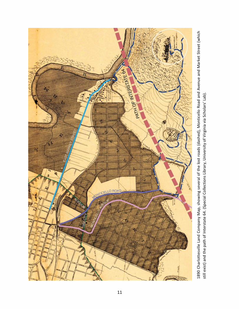
11
1890
Cha
rlottesvilleLan
dCo
mpa
nyM
ap,sho
wingseveralo
fthe
lostro
ads(dashe
d),M
ontic
elloRoa
dan
dAv
enue
and
MarketS
treet(which
stillexis
t)an
dthepa
thofInterstate64
.(Sp
ecialCollectionsLibrary,U
niversity
ofV
irginiaviaScholars’Lab
).
12
II.HISTORICALBACKGROUND
Formostof itshistory, itwaseasytogettoMonticello.Thereweremultiplepossibleroutes:
throughWoolenMills,Carlton,present-dayMonticelloRoadandpresent-dayRoute20.There
was busy commerce along all of these routes and there is enduring evidence—and local
memories—ofthat.Theadventoftheautomobiledidnotitselfcauseadisruption.Duringmy
earlierworkstudyingMonticelloRoad (which inspired thisproject), Imet long-timeresidents
whousedtotravelthatrouteandIheardamusingstoriesofjoyridesalongthesteepandwinding
roadintotown.
Construction of Interstate 64 in the 1960’s sliced between Charlottesville and Monticello,
obliterating those old routes.9 TheWoolenMills/Carlton approaches exist in only on maps;
MonticelloRoadisintwodisconnectedsegments(oneofwhichiscompletelydisused)andthe
MonticelloAvenueapproachwaswidenedtoafourlanedividedhighwaywithoutsidewalks.
Therewas a flurry of institutional building at that same time,with the opening of Piedmont
VirginiaCommunityCollege(PVCC)in1973,theoriginalregionalvisitorcenter(nowPVCCStultz
Center)andtheserialrepurposingoftheBlueRidgeHospital(ultimatelymothballedinthe90’s).
Sincethen,therehasbeensteadygrowthsouthonRoute20(includingseveralsubdivisionsand
ahighschool),butpedestrianaccesshasnotgotteneasier.
Althoughtheycanbestbedescribedasother-than-suitable,Routes20and53weredesignated
partofthenationalBicycleRoute76in1982.
SaundersMonticelloTrail
In 1998, the Thomas Jefferson Foundation took a significant step toward Charlottesville by
openingtheSaunders-MonticelloTrail.ItbeginsataparkinglotonRoute20andwindstwomiles
upthemountainalongwheelchair-accessiblecrushedstoneandboardwalkpathstothevisitor
center at Monticello. The $6.5 million trail was financed through an approximately 50/50
9TheCharlottesvillesegmentopenedin1970.
13
combinationofFederalHighwayfunds(connectedtothedevelopmentoftheThomasJefferson
Parkway/Route53)andanarrayofprivatedonations.
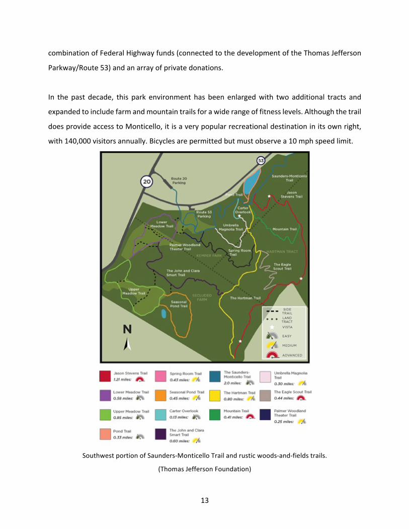
In the past decade, this park environment has been enlargedwith two additional tracts and
expandedtoincludefarmandmountaintrailsforawiderangeoffitnesslevels.Althoughthetrail
doesprovideaccesstoMonticello,itisaverypopularrecreationaldestinationinitsownright,
with140,000visitorsannually.Bicyclesarepermittedbutmustobservea10mphspeedlimit.
SouthwestportionofSaunders-MonticelloTrailandrusticwoods-and-fieldstrails.
(ThomasJeffersonFoundation)
14
III.CURRENTCONDITIONS
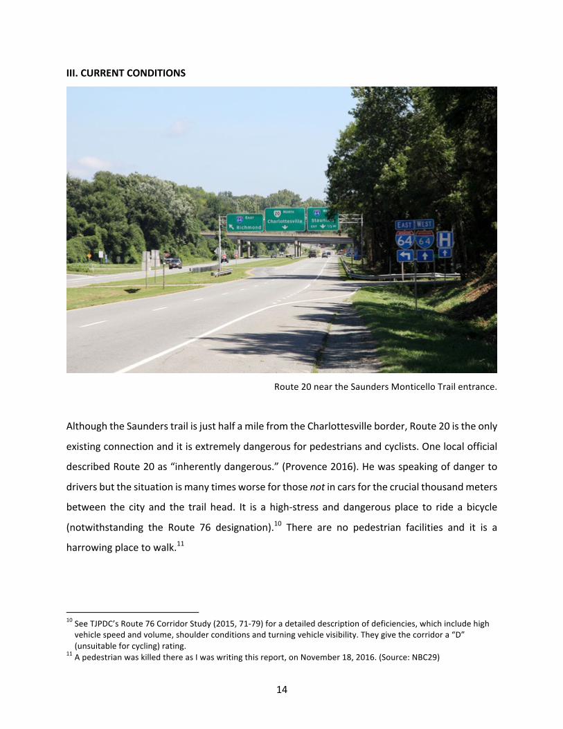
Route20neartheSaundersMonticelloTrailentrance.
AlthoughtheSaunderstrailisjusthalfamilefromtheCharlottesvilleborder,Route20istheonly
existingconnectionanditisextremelydangerousforpedestriansandcyclists.Onelocalofficial
describedRoute20as“inherentlydangerous.”(Provence2016).Hewasspeakingofdangerto
driversbutthesituationismanytimesworseforthosenotincarsforthecrucialthousandmeters
between the city and the trail head. It is a high-stress anddangerousplace to ride a bicycle
(notwithstanding the Route 76 designation).10 There are no pedestrian facilities and it is a
harrowingplacetowalk.11
10SeeTJPDC’sRoute76CorridorStudy(2015,71-79)foradetaileddescriptionofdeficiencies,whichincludehighvehiclespeedandvolume,shoulderconditionsandturningvehiclevisibility.Theygivethecorridora“D”(unsuitableforcycling)rating.
11ApedestrianwaskilledthereasIwaswritingthisreport,onNovember18,2016.(Source:NBC29)
15
Evenifonedoesdrive,itisnoteasytogettotheSaundersTrail.Onecaneitherparkinasmall
(12 space) lot on the Thomas Jefferson Parkway or a larger (50 space) lot on Route 20.
Unfortunately, the larger parking area is only accessible to north-/in-bound traffic and it is
difficult/illegaltomakeaU-turnforotherstogetthere.Nevertheless,eventhislarge,difficult
parkinglotisoftenfull,requiringvisitorstopark(alsodangerously)ontheshoulderofRoute20.
A large additional parking lot exists across 20 at the Stultz Center, which could be ideal for
overflowbutitcannotbemadeavailableundercurrentconditionsbecauseitsentrancehasguard
railshardagainstthetravellanesonbothsidesofabridgeoveramoat-likestream.Furthermore,
althoughitsentrance(CollegeDrive)issignalized,thereisnopedestriancrossing.
Itmightseemobviousthattherebesidewalksand/orbicyclefacilitiesalongRoute20butitwould
bedifficult,owingtoahighwaycloverleafforInterstate64thatisusedatextremelyhighvelocity
andsteepbanksonbothsidesoftheroadway.Fornow,Monticello,theSaunderstrail,Piedmont
VirginiaCommunityCollegeandAlbemarleCounty’sSouthernNeighborhoodarea—allofwhich
areadjacenttoCharlottesville—areeffectivelyseveredtocyclistsandpedestrians.
ItisalsoimportanttonotethattheSouthernNeighborhoodareaandthezonearoundMonticello
arealsoatravelsourcesaswellasdestinations.ThisisnotonlyanissueforCharlottesville;County
residentsarealsocutofffromresourcesintheCity.
OverlappingJurisdictions
Asidefromthedifficultiesrelatedtoterrainandperhapsover-builtinfrastructure,thesituation
iscomplicatedbythesimplefactthatthezoneissplitbetweentwojurisdictions(Charlottesville
and Albemarle County) with a third-party (VDOT) right-of-way in between. So neither
governmentownsthewholeproblem,noriscapableofsolvingitalone.
DiscontinuouspathwaysattheCharlottesville/Albemarleborderarenotuncommon. Itseems
extreme in this case, however, because the change in road typology near the county line is
dramaticandthedisconnectedresourceshaveaveryhighprofile.
16
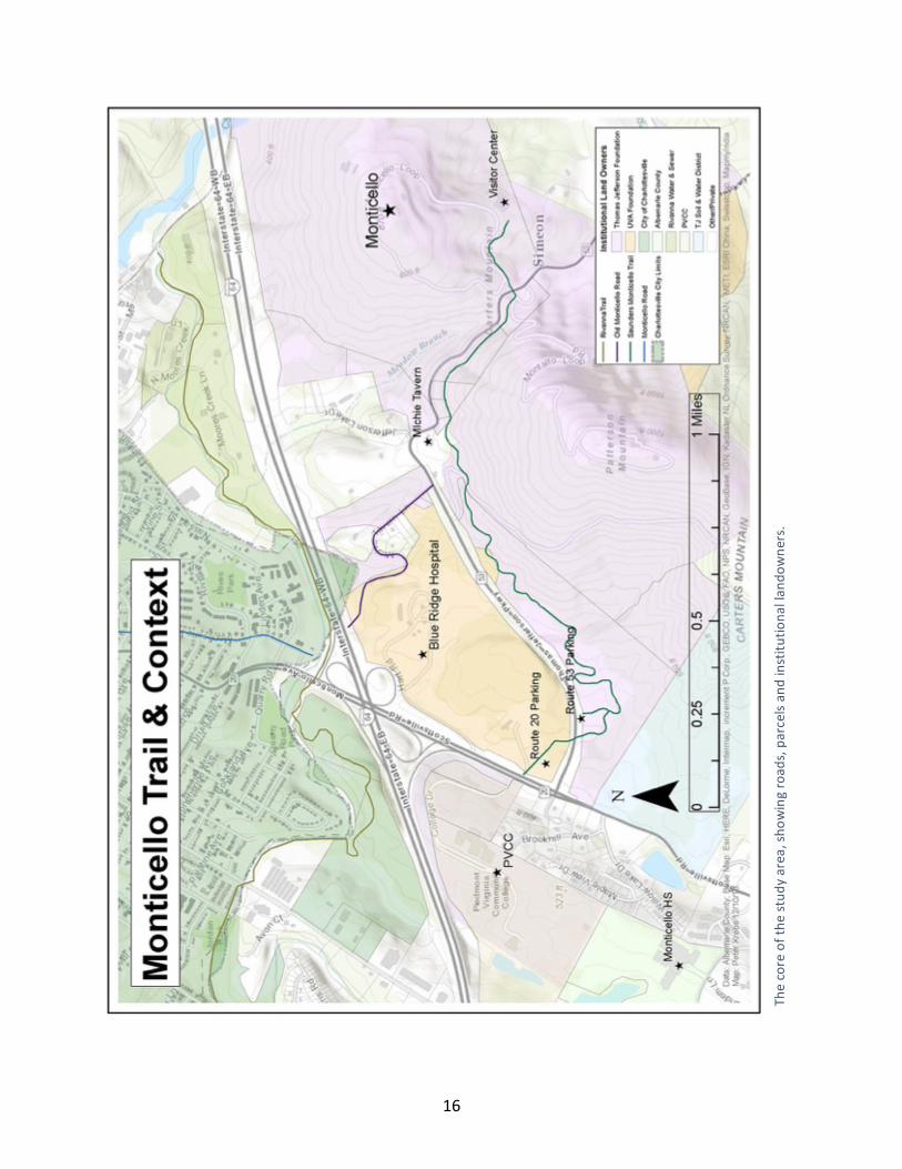
Thecoreofthe
stud
yarea,sho
wingroad
s,parcelsan
dinstitu
tiona
llan
downe
rs.
17
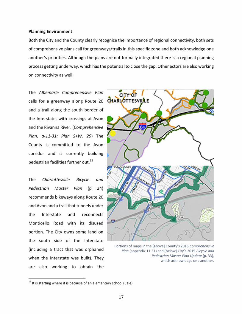
PlanningEnvironment
BoththeCityandtheCountyclearlyrecognizetheimportanceofregionalconnectivity,bothsets
ofcomprehensiveplanscallforgreenways/trailsinthisspecificzoneandbothacknowledgeone
another’spriorities.Althoughtheplansarenotformallyintegratedthereisaregionalplanning
processgettingunderway,whichhasthepotentialtoclosethegap.Otheractorsarealsoworking
onconnectivityaswell.
The Albemarle Comprehensive Plan
calls for a greenway along Route 20
and a trail along the south border of
the Interstate,with crossings atAvon
andtheRivannaRiver.(Comprehensive
Plan, a-11-31; Plan S+W, 29) The
County is committed to the Avon
corridor and is currently building
pedestrianfacilitiesfurtherout.12
The Charlottesville Bicycle and
Pedestrian Master Plan (p 34)
recommendsbikewaysalongRoute20
andAvonandatrailthattunnelsunder
the Interstate and reconnects
Monticello Road with its disused
portion. The City owns some land on
the south side of the Interstate
(including a tract that was orphaned
when the Interstate was built). They
are also working to obtain the
12Itisstartingwhereitisbecauseofanelementaryschool(Cale).
Portionsofmapsinthe[above]County’s2015ComprehensivePlan(appendix11.31)and[below]City’s2015Bicycleand
PedestrianMasterPlanUpdate(p.33),whichacknowledgeoneanother.
18
adjoiningparcelfromtheThomasJeffersonFoundationandtofinalizetheneededeasements
andpermissionsbothinthecityandcounty.Thisplanwouldalsorequireapedestrianbridge
overRoute53nearMichieTavern.ThecountyacknowledgesthistrailonitsMasterPlanmaps
butnotinitstext.
RegionalIntegration
TheThomasJeffersonPlanningDistrictCommission(TJPDC),whichalsostaffstheCharlottesville-
AlbemarleMetropolitanPlanningOrganization,publisheda verydetailedanalysisof theBike
Route76corridor(2015)anditincludestheentireroadportionofthisstudyarea,includingthe
Morvenextension.Theyarealsoupdatingtheir2004JeffersonAreaBikeandPedestrianPlan.
Theprocesswillserveasapracticalguideforlocal,regionalandstatedecision-makers.
Theconnectionexploredinthisassessmentisacruciallinkintheregionalnetworkandacase
study in interjurisdictional problem-solving. Therefore, the TJPDC has agreed to sponsor an
enlarged version of the second part ofmy project in conjunctionwith theirmaster planning
process.
As part of the UVa School of Architecture Urban and Environmental Planning department’s
terminal Practicum course, fiveMasters Degree candidateswill delve deeper into the issues
raisedinthisdocumentandplacethemwithintheregionalplanningcontext.Iwillleadthisteam
andwillbejoinedbyMauraHarris,CarolineHerre,JoelLehmanandJulieMurphy.Iwillreferto
thatefforthenceforthas“thePracticum.”13
It is also significant that the City and the County have signed a series ofMemoranda of
Understandingresolvingthatthetwoentitieswillworktogetheronissuessuchasinfrastructure,
theenvironmentandrecreation.IhavespokenwithmembersofbothPlanningCommissionsand
bothwillbecloselyinvolvedinthestudyasitmovesforward.Theiroccasionaljointmeetingswill
beagoodopportunitytospeakwithbothsimultaneouslyinaninterjurisdictionalforum.
13FulltextofthesuccessfulproposalisincludedinAnnexA.
19
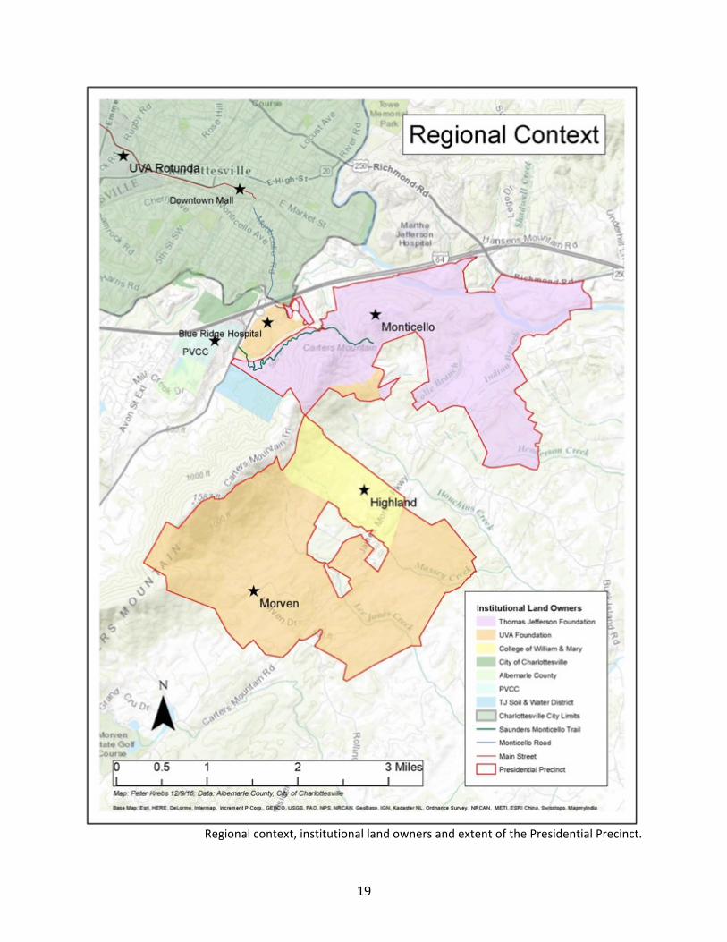
Regionalcontext,institutionallandownersandextentofthePresidentialPrecinct.
20
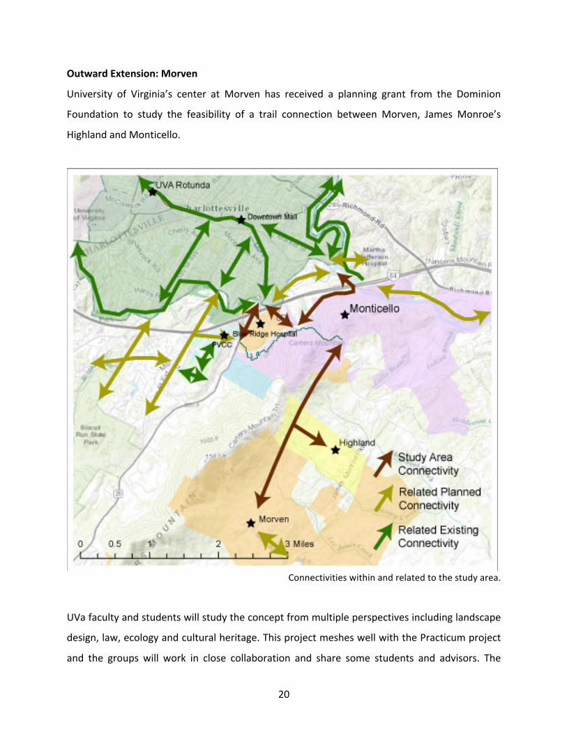
OutwardExtension:Morven
University of Virginia’s center at Morven has received a planning grant from the Dominion
Foundation to study the feasibility of a trail connection between Morven, James Monroe’s
HighlandandMonticello.
Connectivitieswithinandrelatedtothestudyarea.
UVafacultyandstudentswillstudytheconceptfrommultipleperspectivesincludinglandscape
design,law,ecologyandculturalheritage.ThisprojectmesheswellwiththePracticumproject
and the groups will work in close collaboration and share some students and advisors. The
21
combined trailwill extendmore than eightmiles and connect Charlottesvillewith the vast14
PresidentialPrecinct—andbeyond.
LandOwnership
Mostofthelandsurroundingthepotentialtrailroutesbelongstoinstitutionsthatendorsethe
trail idea. These include theThomas JeffersonandUniversityofVirginia Foundations,Cityof
Charlottesville,AlbemarleCountyandHighland.Thereare someprivate residencesalongOld
MonticelloRoad(nowcalledMichieTavernLane)andMichieTavernitselfisprivateaswell.They
haveconcernsbuttherearealsoopportunities(especiallyforhospitality),locatedastheyarein
theheartofthestudyarea.Somepotentialroutesdonottouchprivatelandatall.
Ofparticularinterest,theBlueRidgeHospitalsitsrightinthecenterofthestudyareaandseveral
possible connections pass along its periphery (or potentially through it). The 142-acre site
belongstotheUVaRealEstateFoundationandmanypeoplehavehadideasabouthowtouseit,
includingamajorresearchproject in2002directedbyDanielBluestone,whowasthenaUVa
professor. The site is currently disused, with several historic buildings that are closed and
carefullypreserved.
VirginiaDepartmentofTransportation(VDOT)controlstheright-of-wayaroundtheInterstate.
Theyareawareof—andacceptingof—thetunnelconcept.
NotethattherehavealsobeensuggestionsaboutaccessingMonticellofromtheeast—either
fromWoolenMillsorShadwell—butMonticellodoesnothaveinfrastructuretoreceivevisitors
toitseasternflankatthistime.Althoughthepracticumwillincludetheconcept,itisunlikelyto
bepartofanear-termsolution.However,thatapproachdoespossessthevirtueofavoidingthe
Interstate completely and could be important for regional connectivity so it should not be
omittedeither.
14Approximately6,000acres(perGISanalysis).
22
TherearealsoafewprivatepropertiesbetweenMonticelloandMorven.Dependingontheroute
selectionfromMonticellotoMorven,easementswillbeneededforthatextension.Thatwillbe
atopicoftheCulturalLandscapescourseandarelatedclassattheUVaLawSchool.
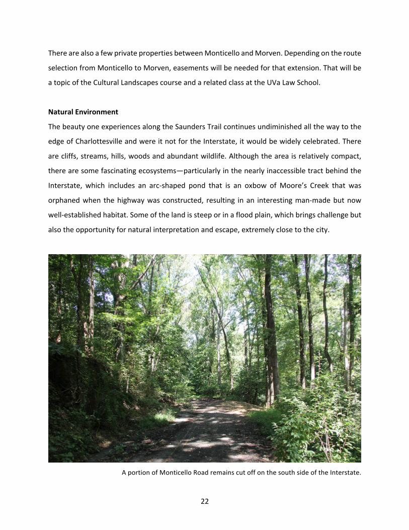
NaturalEnvironment
ThebeautyoneexperiencesalongtheSaundersTrailcontinuesundiminishedallthewaytothe
edgeofCharlottesvilleandwereitnotfortheInterstate,itwouldbewidelycelebrated.There
arecliffs,streams,hills,woodsandabundantwildlife.Althoughtheareaisrelativelycompact,
therearesomefascinatingecosystems—particularlyinthenearlyinaccessibletractbehindthe
Interstate, which includes an arc-shaped pond that is an oxbow ofMoore’s Creek that was
orphanedwhen thehighwaywasconstructed, resulting inan interestingman-madebutnow
well-establishedhabitat.Someofthelandissteeporinafloodplain,whichbringschallengebut
alsotheopportunityfornaturalinterpretationandescape,extremelyclosetothecity.
AportionofMonticelloRoadremainscutoffonthesouthsideoftheInterstate.
23
CulturalLandscape
Thestudyareaisevenricherinsocialhistoryandthepotentialforhistoricalinterpretationisso
clearandsovastthatIdidnotexploreitindepthforthisassessment.Innumerablestoriesand
liveshaveunfoldedinthisspaceandthereisapowerfulsenseamongthestakeholdersthatthis
aboutmorethanaphysicallink.
Monticello is serious about exploring connections between the heritage site and the local
community,particularlywithrespecttothedescendantsofenslavedworkers.Theyhavehired
two community engagement officers, one ofwhom is a recent graduate of the Architecture
School.Theywillbecrucialresourcesfortheprojectteam.
Thestoryof theconnectionbetweenMonticello,HighlandandMorven is fascinatingaswell,
offeringalternativewaystoviewtheAmericanstory, fullcalendarsofcommunityeventsand
programs that look toward a sustainable future. The discoveries from the Morven trail
explorationswillenrichthisprojectandtheprospectoflinkingMorventotheUniversityGrounds
iscompelling.
Thisentirenarrativeextends throughCharlottesville’sDowntown, to the JeffersonSchool for
AfricanAmericanHeritage,UVa’sRotunda,andwellbeyond. Itwill intertwinewiththefuture
Three-Notch’dTrailtravellingpastIvy,RockfishGap(wheretheUniversity’ssitewasselected15)
andonintotheShenandoahValley.Theopportunityforexpressionofheritagethroughthistrail
anditsextensionsissimplybreath-taking.
VulnerableCommunities
There ismuch, though alsomuch-debated, literature positing that Creative Class16 amenities
(suchasbiketrails)canhaveanegativeeffectoncommercialandresidentialrentaffordability.
Most of the likely routes for the trail would terminate in either Belmont or Carlton—two
15Blackwell’sTavern.16OnequalitythatpeoplelikebestabouttheSaundersTrailisthatitisoneoftheleastsegregatedpublicspacesintheregion.Todismissthisprojectaselitistorfortheprivilegedwouldbeamisreading.
24
historicallyaffordableneighborhoodsthateitherarecurrentlyexperiencingorcouldsoonsee
pricepressurewithorwithout this enhancement.Onehas towonder if a trail toMonticello
landingintheneighborhoodcouldindirectlycausedisplacement.Stakeholderreactionstothis
questionweremixed,thoughat leastonetoldmethateventheperception(trueornot) isa
concernthatneedstobetakenveryseriously.ThePracticumwillneedtoexplorethisissue.
25
IV.KEYINSTITUTIONALSTAKEHOLDERS
This is apartial listof stakeholders I have identifiedand/orengaged. Seeappendices for key
contactsandaninterviewlog.Stakeholdersidentifiedwithanasterixwerenotinterviewedbut
shouldbeinvolvedwiththeprocessgoingforward.
ThomasJeffersonFoundation(Monticello)
Monticelloistheindispensablepartyinthiseffort.Theymaintainandoperatethehistoricestate
andownmuchoftheinterveningandsurroundingland,includingtheSaundersMonticelloTrail.
Theyhavecapacitiesrelatedtoplanning,education,outreach,publicprogramsandphilanthropy,
allofwhichshouldbeinvolvedinthediscussion.
Government
CityofCharlottesville
City Council and Planning Commission both have jurisdiction. Staff: Parks & Recreation;
Neighborhood Development Services (including Transportation, Planning and Housing);
Bicycle/PedestrianAdvisoryCommittee*,EconomicDevelopment*
AlbemarleCounty
Board of Supervisors and Planning Commission have jurisdiction. Staff: Parks & Recreation;
Transportation; Economic Development* (Note: the City and County Planning Commissions
periodically meet jointly. It is conceivable, and possibly desirable, to brief them both
simultaneously.)
CommonwealthofVirginia
VirginiaDepartmentofTransportation*controlstheInterstateright-of-way,aswellasthatof
themajor routes. Theywill need toapproveanyprojectsdealingwith the Interstate, county
roads,orusingstatemoneyfortransportationpurposes.Otherstate-leveldepartmentswillalso
likelybeinvolved,suchasDEQ.
26
ThomasJeffersonPlanningDistrictCommission
The TJPDC is the regional planning organization for Charlottesville and the five surrounding
counties.Theywouldbeanessentialconveningentity inanycasebuttheircurrentdecennial
multimodalplanningupdateandsponsorshipofthePracticumplacesthematthecenterofthe
effort.
PresidentialPrecinct
The Presidential Precinct is a non-profit that unites theUniversity of Virginia, the College of
William&Mary,WilliamShort’sMorven, and thehomesof three Founding Fathers, Thomas
Jefferson’sMonticello, JamesMonroe’s Highland and JamesMadison’sMontpelier.17 Four of
thesefivepartiescontrolmuchoftheacreagesurroundingthestudyarea.Theirpropertiesare
bothdestinationsandculturallandscapes,eachhavedistinctmissions,perspectives,programs
andfundingcapacities.
Education
UniversityofVirginia
The Architecture School is deeply involved in this endeavor. This assessment and the two
upcomingtrailplansarestudentprojects.Multiplestudentswillbeworkingontheprojectand
several members of the faculty—particularly the Department of Urban and Environmental
Planning—willbeadvisors.AdditionalpartnersincludetheCenterforCulturalLandscapesand
theOfficeoftheArchitect.*
UniversityofVirginiaFoundation
TheUVaFoundationmanagestheUniversity’srealestateholdings,whichincludesMorvenand
theBlueRidgeHospitalsite—bothkeypropertieswithinthestudyarea.
17Montpelierisnotinthestudyarea.
27
Morven
ImentionMorven an additional timebecause theywill play a research andpedagogical role
(through their sponsorshipof theCultural Landscapes class) in addition tobeing institutional
stakeholders.
PiedmontVirginiaCommunityCollege
Theyarenotaformalpartofthestudybuttheyaresocloseandtheirroleinregionalhumanand
economicdevelopment is so important that theyneedtobe involved.They justcompleteda
Campus Master Plan but it does not speak about connections to the outside world or
bicycle/pedestrianaccessibility.
LocalSchoolDistricts*
Thoughnotdirectlyresponsibleforlanduseortransportationplanning,theywillbecentralto
programming decisions and advocating for the needs of young residents. Their needs and
capacitiesneedtobeconsidered.Severalschoolsarenearthestudyarea.
AdditionalNon-ProfitOrganizations*
Ihavenotreachedouttoanyoftheseentities,buttheycouldbeimportantstakeholdersgoing
forward.Thelistisbynomeansexhaustive.
CulturalHeritage:PreservationPiedmont;JeffersonSchoolAfricanAmericanHeritageCenter
EconomicDevelopment/Tourism:CharlottesvilleAreaVisitorsBureau
Environmental:Friendsof theMonticelloTrail;PiedmontEnvironmentalCouncil;RivannaTrail
Foundation.18
HousingandCommunityDevelopment:HabitatforHumanity;PiedmontHousingAlliance
Neighborhoods:53/20Club;BelmontCarltonNeighborhoodAssociation;WoolenMills
Recreation:CharlottesvilleAreaMountainBikeClub;OutdoorsAdventureClub;Charlottesville
TrailRunningClub
18TheydevelopedandlargelymaintaintheRivannaTrail,alikelycasestudy.
28
V.SUMMARYOFIDENTIFIEDOPPORTUNITIESANDISSUES
Theassessmentprocess is all about learning.As Iwent fromstakeholder to stakeholder,our
groundrulesstatedthatall ideasarevalidandwouldberecorded.Icategorizedthefeedback
intofourcategories—Benefits(primaryandsecondary)andChallenges(strategicandtactical).It
willbeforthelaterprocesstodigestthemandweighthemagainstoneanother.Manyofthem
havebeendescribedinthereportnarrative.Thisisthefulllist,innoparticularorder.
PrimaryBenefits
Thesearedirecttacticalbenefitsthatwouldflowfromasuccessfulproject.Notonlyisthatuseful
forjustifyingfundingorinweighingdifficultchoices,italsobeginstoresemblealistofsuccess
conditions.
• ConnectCitytoMonticello
• ConnectUVaRotundaandMonticello
• ConnectUVaGroundswithMorven
• Facilitateauto-freecommuting
• Non-standardconnectivity(reversecommuting,recreation,dendritic/lateral)
• GreateraccesstoPVCCandSouthernNeighborhoodArea
• ProvidenewaccesspointtoSaundersTrail,alleviatingparkingshortageanddangerous
entrypatterns
SecondOrderBenefits
Thesearesocialbenefitsthatarelikelytoflowfromtheprimary.
• Morerecreationalopportunities
• Moreexposuretonature
• IncreasedandmorediversevisitationtoMonticello,Highland
• Opportunity/ChallengeforMorventobecomeatrulypublicsite
• Economicdevelopment:tourism
• Economicdevelopment:boosttoneighboringbusinesses,multipliereffect
• Economicdevelopment:businessattraction
29
• Restoringabrokenphysicalconnectionwillfacilitateprogrammaticconnections
• ActivateBlueRidgeHospitalsite
• BikeRoute76willavoidaveryharrowingsegmentwitha“lowcompatibility”ratingyeta
prominentlocation.19
• Unlockspotentialbike-friendlyareaseastandsouthofBrown’sMountain
• Interpretationopportunities:culturalheritage
• Interpretationopportunities:nature
• Betterconnectiontonatureincoreareaencouragessettlement incore(buttrailzone
itselfisprotectedsoitisassuredtoremainpark-like)
• Modelforbetterregionalcooperationaroundasharedopportunity
• Modelforissuesincomprehensiveplansactuallybeingimplemented
• Casestudyforrestoringconnectivitiesbrokenby20thCenturinfrastructure
• Opportunitytothinkofopenspaceinnewways,justastheSaundersTraildid
• Strong,physicalstatementofcommunityvaluesinahighlyvisiblelocation
StrategicChallenges/Opportunities
Thesechallengeswillneedtobeaddressedforanyroute
• Aregionalapproachisneeded;butthetraditionalapproachisjurisdictionallysiloed.
• SeveralentitiesareworkingonMonticelloconnectivity(Highland,Morven,City,County).
Theyneedtoworkinconcert.
• TheInterstateisaformidablebarrier—physicallyandpsychologically.
• Themost obvious route (20) has a design that encourages highway speeds and that
arrangementseenaslocked-in.
• Multipleapproachesarepossible,eachwithdifferenttacticalissues.20
• Thepursuitofoneroutebynomeansexcludestheotheroptions;quitethecontrary:their
valuewouldbecumulative.
19TJPDC2015,5.20Identifiedroutes(listedcounter-clockwise):Morven*;Shadwell;alongtheRivanna;MonticelloRoadextended*;MonticelloAvenue*;viaculverttoPVCC;Avon+PVCCWoods*.*Theseroutesrecommendedforfollow-up.
30
• TheSouthernNeighborhoodareaisanimportantpartoftheCounty’splans.
• ThereisworkalreadyproceedingalongAvonStreet.
• TheinaccessibilityofPVCCmirrorsthatofMonticello,witharguablyevenlargerequity
issues.Opportunitiesexisttosimultaneouslyaddressboth.
• KemperPark/SaundersTrail isa locallyunusualpark resource. It ispublicbut it isnot
publiclyownedunlike, forexample,SkylineDriveor theDowntownMall.TheRivanna
Trail,whichisalsoahybrid(thoughdifferent)typeofspace,hasseenchallenges.
• Issuesaroundconnectivityandheritagearebothhighlycontested.
• PotentialforgentrificationinBelmontandCarlton.Potentialtobecaughtinbroadercity-
wideconcernabouttheintersectionofamenity,opportunityandhousing.
• Landusechangescouldimpactnearbybusinessespositivelyornegatively.
• MostofthestudyareaiswithinMonticello’sviewshed.
• Nobodywantstoworkonanotherplanthatwindsupontheshelf.
• Increasedvisitationwillimpactinfrastructureatallstakeholdersites.
• Therecouldbeoppositionfromasmallnumberofneighboringprivatelandowners.
• Increasedparkusershipcoulddecreaseparktranquility.
• UpstreaminfrastructureintheCity(especiallyMonticelloAvenue)isnotcurrentlyready.
Note,however,thatMonticelloAvenueisapriorityforbicycle/pedestrianimprovement,
withnearlycompletesidewalksandbikelanesplannedfor2017.
Cross-CuttingTacticalChallenges
Thesearetacticalquestionsthatwillneedtobeaddressedonceanoverallconceptisdecided.
Mostarecommontoanyapproach—indeed,toanyprojectofthiskind.Route-specificissueswill
beexploredif/whenroutesaredefined.
• Someonewouldneedtoownit
• Therewillbecost,potentiallylarge
• Parking
• SecurityatallsitesbutespeciallyMonticello
• Liability

31
• Bathrooms
• Trespassonneighboringland
• Sensitiveecosystems
• Land/EasementAcquisition
• Programming
• Flood zones with occasional intense episodes. Particularly (but not only) onMoore’s
Creek
• Possiblesensitivearcheologyorhabitats
• Interpretationandprogramming
32
VI.RECOMMENDEDPLANNINGAPPROACH
Besidesmakingcontacts,exploringtheterrainandcollecting information, thepurposeof this
assessment has been to determine if it is appropriate for a Master Planning Process to go
forward.Ifindthattobethecase:thecircumstancesarerightandthestakeholdersareready.
Indeed,severalofthemhavealreadystarted.
ThisfinalsectionwillcombinelearningsfrommyconversationswithstakeholderswithwhatI
havelearnedaboutPlanningTheoryandPracticeinmyMaster’sprogram.Theyareorganizing
principlestohelpmaketheprocessandresultsefficacious,equitableandjust.
ACollaborativeProcessthatProducesaUnifiedResult
Thisisanexcitingtopicanditisgoodthatmanypeopleandorganizations—pastandpresent—
areworkingtoimproveconnectivityandbringopportunitytomorepeople.Yet,thestakeholders
eachknowthattheycannotsolvetheproblemalone.Thatwasclearfrommyfirstdiscussion:a
collaborativeapproachwillbenecessary.
Therearemanyinterconnectedpiecesandoverlapping issuesthatcannotbedisentangled. In
some ways, uncoordinated effort is how we got where we are today. TheMaster Planning
process that followsmust bring rational coherence to themany relatedplans fromdifferent
interestgroups,pastandpresentsotheactorswillhavefiniteoptionstopursuewithseriousness.
Weare fortunate thatTJPDC is already conveningan interjurisdictionaleffort. ThePracticum
group will work with this framework, bring in non-governmental stakeholders and leverage
collaborativeplanningresourcestheArchitectureSchooloffers.
Planimplementationwillmostlikelyrequiresomekindofcollaborativeworkinggroup,whichwill
likelyhaveatleastsomeoverlapwiththePracticum’sadvisoryboard.Indeed,thegroupwillbe
recruitedwiththat inmind.Fosteringhorizontalcollaborationswithinthatgroupwillhelp lay
institutionalgroundworkforfutureendeavors.
33
RegionalPerspective
Theplanmustcontributetoabetterregionalmultimodalnetworkanditmustconsiderfactors
outside of the study area’s boundaries. There are other nodes and opportunities in the
neighborhoodbesidesCharlottesvilleandMonticello.Thisprojectwilladdtoandlearnfromthe
TJPDCeffort.
NoPlansonaShelf
AllofthestakeholdersIspoketorepresentbusyorganizationsdoingamazingthings.Theyare
passionateintheirdesiretofindasolutionbuttheydonothavetimeforidlechatter.Theyhave
allseenmanygreat ideas—includingprojectssimilar tothisone—windupasnotebooksona
shelfandnothingmore.Thisprojectneedstobringresultsandifitdoesn’t,itwillmakethenext
effortmoredifficult.
In that respect, the Practicum, andwhatever form its successor effort takes,will need to go
beyond both decennial TJPDC Plan (which is self-consciously not advocacy) and theMorven
Project(whichisanacademicexercise).Thoseprocesseswillsetthetablewellbuttheprocess
also needs to havemomentum thatwill grow instead of subsidingwhen all the reports are
submitted.
We have identified several organizations that can champion the project and keep itmoving
towardimplementation.ThePracticumgroupmustworkwiththemtodefineactiveroles,keep
themengagedandidentifyresourcesforthestakeholderstodoactualworkontheground.
FairProcesswithJustOutcome
Wehaveseenplanningprocessesthatexcludethosetheyintendtoserve.Wehavealsoseen
goodintentionsthatleadtotragicresults.Althoughthisprojectseemsquitebeneficial,wemust
be vigilant forpotential harms suchas gentrification andof pastwell-meaningbutunhelpful
intrusionsbytheUniversityintocommunitylife.
34
YetwemustalsomakeavailableUVa’sconsiderableresourceswhentheycanmakeapositive
difference.Thisisnotaneasybalance,butitwillhelptobehumbleandself-criticalandwaryof
thepitfallsthetheoreticalliteratureandlocalexperiencewarnusabout.Thatdoesn’tmeanthat
weshouldavoidambitioussuggestions;itmeansweshouldbecircumspect.
Don’tRespondtoObduratePhysicalLegacieswithStubbornPlans
There is an interesting theoretical nexus between the obduracy of legacy infrastructure and
corrective plans, which sometimes become obstinate themselves. [See Appendix D] When
designersspendtimeenvisioningalternativefutures,theyoftenbecomeinvestedintheirideas.
When they present their plans and designs to the public—particularly if they are refined or
representmajorinvestments—thoseplanscanthemselvesbecomestakesinthegroundthatthe
publiccanacceptormodifybutnotfundamentallyre-think.
Yetdesigners’abilitytoenvisionalternativepossibilitiesisoftenthebestwaytoanswerawell-
entrenchedstatusquo.Itisdifficulttobalanceenthusiasmaroundanideathathasthepowerto
motivatechangewhilealsobeingopentorealcontributionsandalternatives.Thesolutiontothe
dilemmaisforthedesignprocessitselftobeapubliccollaboration.
TheMonticelloTrailwasdesignedbyasingle firmwithmagnificentresultsbut thatwasonly
possiblebecausetheThomasJeffersonFoundationcontrolledmostoftheland—andeventhat
requiredbothleadershipandlistening.Tocompletethislink,theprojectwillneedmorethanone
owner,includingpublicagencies.Thatmeansthattherewillneedtobepublicinvolvement.The
best, most inclusive, results will happen if the public is invited in as soon as the broadest
conceptualissuesareresolved(e.g.whatcombinationofstakeholderswillowntheprojectand
wherewillitbe.)Don’twaituntileverythingofconsequenceisalreadydecided.
35
IssuesforthePracticumGroup
AlthoughthePracticumgroupwillreceiveitsofficialassignmentafterthisreportiscomplete,it
should closely resemble the proposal I wrote earlier in the Fall (see Appendix A). Generally
speaking, itwillclarify issuesandidentifyprecedents,opportunitiesandsolutions. Itsprimary
clientwillbetheTJPDCbutitwillworkcloselywiththeMorvenprojectandtheCenterforCultural
Landscapes.ItwillreceivesignificantadviceandinputfromtheArchitectureSchoolaswell.
Herearesomeissuesfortheteamtoexamine:
1. Possibleroutes:advantages,disadvantagesandprecedents
2. Contextwithinandcontributiontoabettermultimodalregionalnetwork
3. Culturalandenvironmentaleducation;Opportunitiesforprogramming
4. EconomicImpact—shortandlongterm
5. Possiblegentrificationandproactive/preventativestrategies
6. ResourcesandFunding
7. WhousestheSaundersTrailandhow.Whoifanyoneismissing?
8. Process to keep the stakeholders engaged, involve the community and build forward
momentum
Thiswillbeagraduate-levelprocess,conductedbyaselectgroupwithinarenownedprogram.It
isourexpectationthattheresultwillreflectbestpracticesandbetheoreticallyrigorous.Wealso
knowthatexpertise isproblematicandhas its limitations.Therearemanyknowledges,many
withexperienceandideasaboutthisuniquespace.
TheproblemofconnectingacitytoaheritagesitelikeMonticelloisarareopportunitytomodel
acollaborativeapproachandanewkindof transportationplanning that isaboutmeaningas
muchasitisaboutinfrastructure.Wehavethepossibility(thereforearesponsibility)tomove
theprofessionforwardandmakearealandlastingdifference.
36
SOURCESBibliographicSourcesLocalHistoryandEventsBleam,Greg,etal.1998.CityasaPark:ACitizen’sGuidetoCharlottesvilleParks.Buck,JamesH1980.Belmont:HistoryofaNeighborhood.UniversityofVirginia,CESS530--Local
History,prof.JamesKinard25pp.Buehler,Ralph,ThomasGötschiandMeghanWinters.2016.MovingTowardActive
Transportation:HowPoliciesCanEncourageWalkingandBicycling.ActiveLivingResearch.
Kelly,Jane2016.“HappyTrails:AGrantfromTheDominionFoundationWillSupportUVA’s
ExplorationofaHistoric,Six-MileTrailthatLinksMorvenFarmwithHighland,TheHomeofJamesMonroe,andThomasJefferson’sHomeandPlantation,Monticello.”UVAToday.Nov.3[https://www.news.virginia.edu/content/new-grant-supports-uvas-exploration-historic-presidential-pathway]
McNair,Dave.2007.“UVAtoDemo23BuildingsatBlueRidgeHospital.”TheHook.May21.
[http://www.readthehook.com/77000/uva-demo-23-buildings-blue-ridge-hospital]Provence,Lisa.2016.“‘InherentlyDangerous’:Route20ClaimsAnotherlife.”CvilleWeekly.Oct.
15.[http://www.c-ville.com/inherently-dangerous-route-20-claims-another-life/#.WC3g19xT6RM]
NBC29.2016.“PedestrianwhowasHitbyCarDies.”November21.
[http://www.nbc29.com/story/33749649/pedestrian-who-was-hit-by-car-dies]Zechmeister,Gene.2011.“EstablishmentoftheUniversityofVirginia.”ThomasJefferson
Foundation.June28.[https://www.monticello.org/site/research-and-collections/establishment-university-virginia]
LocalPlanningDocumentsAlbemarleCounty.2015.ComprehensivePlan,Appendix11:ParksandRecreation,Greenways,
Blueways,andGreenSystems.AlbemarleCounty.2015.SouthernandWesternUrbanNeighborhoodsMasterPlan.CityofCharlottesville.2015.BicycleandPedestrianMasterPlanUpdate.
37
MorvenFarm(UniversityofVirginia)2016.DominionFoundationTrailGrant:DraftProposal(internaldocument).
RivannaTrailsFoundation.StrategicPlan2005-2010.AccessedofNov.4,2016from:
http://www.rivannatrails.org/page-952616Snyder,Rebecca,JaneyCrouseandTerryMargaretTulloch.2002.BlueRidgeResearchPark
Proposal:AdaptiveReuseoftheBlueRidgeSanatorium.UniversityofVirginiaThomasJeffersonPlanningDistrict.2004.JeffersonAreaBicycle,Pedestrian,andGreenways
Plan.ThomasJeffersonPlanningDistrict.2015.BikeRoute76CorridorStudy.ThomasJeffersonPlanningDistrict.2016.JeffersonAreaBikeandPedestrianPlanScopeof
Work.PlanningProcess,ContextandPrecedentsCarcasson,MartinandLeahSprain.2015.BeyondProblemSolving:ReconceptualizingtheWork
ofPublicDeliberationasDeliberativeInquiry.CommunicationTheory.Firehock,Karen.2012.EvaluatingandConservingGreenInfrastructureAcrosstheLandscape:a
Practitioner’sGuide.GreenInfrastructureCenter/VirginiaDepartmentofForestry.Fischler,Raphaël.2012.“FiftyThesesonUrbanPlanningandUrbanPlanners.”Journalof
PlanningEducationandResearch.32:107.Forester,John.2009.DealingwithDifferences.NewYork:OxfordUniversityPress.Leigh,NealandEdwardBlakely.2013.PlanningLocalEconomicDevelopment.(p.110)
Washington,DC:Sage.Marcuse,Peter.2016.“TheThreeHistoricCurrentsofCityPlanning.”InReadingsinPlanning
Theory(pp.116-131).Malden,MA:Wiley/Blackwell.W.K.KelloggFoundation.2004.LogicModelDevelopmentGuide.Wormser,Lisa.1995.“Enhancements:Gettinguptospeed.”Planning,61(9),10.DataAlbemarleCountyRealEstateParcelDataCityofCharlottesvilleAssessor’sOffice
38
MapsAlbemarleCountyCityofCharlottesvilleBaseMap:Esri,HERE,DeLorme,Intermap,incrementPCorp.,GEBCO,USGS,FAO,NPS,NRCAN,
GeoBase,IGN,KadasterNL,OrdnanceSurvey,,NRCAN,METI,ESRIChina,Swisstopo,MapmyIndia.
UniversityofVirginiaSpecialCollectionsLibrary,CharlottesvilleLandCompanyMap(1890)
accessedviaScholars’Lab.[http://scholarslab.org/digital-humanities/charlottesvilles-street-car-system-in-gis/]