Reconnaissance of Vegetation and Soils Along the Dempster ...
32
Environment Environnement Canada Canada Canadian Service FOreSW canadien des Service iorets ISSN0705-3274 Reconnaissance of Vegetation and Soils Along the Dempster Highway, Yukon Territory: I. Vegetation Types W. Stanek. K. Alexander and C.S. Simmons BC-x-217
Transcript of Reconnaissance of Vegetation and Soils Along the Dempster ...

Environment Environnement Canada Canada
Canadian Service FOreSW canadien des Service iorets
ISSN0705-3274
Reconnaissance of Vegetation and Soils Along the Dempster
Highway, Yukon Territory: I. Vegetation Types
W. Stanek. K. Alexander and C.S. Simmons
BC-x-217

n L
Table of Contents Acknowledgments ........................................................................................... 2
Summary ......................................................................................................... 3
Introduction ..................................................................................................... 5
Methods ........................................................................................................... 6
Results . . A. Descriptions of Vegetation ..................................................................... 9
B. Discussion of Discrete Sections .............................................................. 28 1. Areas from KIondike Highway to North Fork Pass 2. Section 1 - South Ogilvie Mountains 3. Section 2 - North Ogilvie Mountains 4. Section 3 - Eagle Plains 5. Section 4 - Western Foothills of the Richardson Mountains 6. Section 5 - Richardson Mountains 7. Section 6 - Eastern Foothills of the Richardson Mountains
References ....................................................................................................... 31
Canadian Forestry Service Pacific Forest Research Centre
506 West Burnside Road Victoria, B.C. V82 1M5
BC-X-217,1981
Acknowledgments Contracts were issued for the vegetation data collection to H. Vaartnou and Sons Enterprises Ltd, 2950 Lansdowne Rd., Victoria, B.C., Can- ada V8R 3R2. Of particular value was botanical information provided graciously by Dr. P.L. Nimis, Professor a t the University of Trieste, Italy'. Thanks are extended to Drs. E.T. Oswald, J. Senyk and R.B. Smith, Mr. AI MacEwan and Mr. K. Friesen, all of the Pacific Research Centre, for reviewing the manuscript, Dr. E.T. Oswald for several photographs, and to Messrs. R.A. Owens and Mark Lesky, Foothills Pipe Lines (South Yukon) Ltd.. and Messrs. L.A. Smithers, Mike Romaine and C.E. Brown, Can- ada Department of the Environment, who con-
tributed in various ways. Foothills Pipe Lines (Yukon) Ltd., Calgary, Alberta, made available maps of the route alignment, black and white aerial photographs and reports, essential mate- rial which greatly facilitated the work. Foothills and the Federal Department of the Environment funded the project.
'It is anticipated that some of the information will be pub- lished in: Nimis, P.L. 1981. Epigaenous lichen synusiae in the Yukon
Nimis. P.L. 1981 Phytogeography of the southern Yukon. (in Territoly. Revue. Bryol. Lich. (in press).
preparation).
3
SUMMARY This report is the result of a survey completed in 1979, along the Dempster Highway, Yukon Ter- ritory, from the North Fork Pass (lat 64"30W long 138O15'W) to Peel River, Northwest Territories (67"22W, 134O55'W). The survey was sponsored by Foothills Gas Pipe Lines (Yukon) Ltd. and the Canadian Department of the Environment, Cana- dian Forestry Service. Cover/abundance values were estimated for 90 species in 100 plots. From the same locations, information was obtained on depth to permafrost in September, generic soil types, soil texture, thickness of the L-H or 0 layers, exposure, slope, elevation, soil modifying processes and pH values of organic and mineral soils. The report con- tains the description of 20 vegetation types and a discussion by sections of vegetation related geological, climatical. edaphical and pedological aspects. The results are tentative but provide a framework for a more complete ecological inventory and information for revegetation projects.
Adjacent to the Dempster Highway, three areas were identified which merit more detailed botanical surveys: (1) North Fork Pass (Section l), on account of many arctic "alpine" species; (2) the calcareous formations of the Ogilvie mountains (Section 2). for the presence of many potentially rare species. pro- bably glacial relicts. the varied geomorphy and the complexity of successional series; (3) the alpine ranges of the Richardson Mountains (Section 5) heretofore little investigated.
RESUME Le present rapport donne les rkdta ts d'une
etude r&lise en 1979 le long de I'autoroute Demp- ster, ab Yukon, entre le col North Fork (64'30" 138'15'0) jusqu'a la riviere Peel dans les Territoires du Nord-Ouest (67"22'N, 134O55'W). Parrainbe par la Foothills Gas Pipe Lines (Yukon) Ltd. et le Service canadien des for& du ministlre canadien de I'En- vironement. cette etude. avait trait a I'estimation du rapport couverture/abondance pour 90 esplces dans 100 placettes ainsi qu'a la collecte de donnees sur la presence du pergdiisol en septembre. le type gcnerique de sol. sa texture, I'espaisseur des couches L-H ou 0, I'exposition, la pente. la hauteur, les processus agissant sur les sols et le pH des sols organiques et minhaux.
Le rapport comporte la description de 20 types de vrigktation trouves dans cette etude ainsi qu'une discussion des aspects environnementaux et botani- ques pertinents. Une kaluation plus poussie des donnees ainsi recueillies sera entreprise en vue de determiner certains aspects environnementaux specifiques. Ce rapport servirait plut6t A prkoir des applications oh les conditions ixologiques doivent &e kaluees ou bien lorsqu'il faut prtparer un relevi t5cologique plus complet.
Le rapport determine trois rbgions qui meriteraient un relev6 botanique plus detaille le col North Fork, B cause de ses nombreuses especes alpines rares de I'Arctique; les Ogilvies calcaires. B cause de la presence de nombreuses especes rares. probablement relictes de la pbriode glaciaire, de la vankt6 des situations ghnorphologiques ainsi que de la complexit6 des successions et les parcours alpins des monts Richardson, jusqu'ici peu Ltudies. Dans I'ensemble. les regions du col North Fork et les tenes adjacent- a la riviere Ogilvie sont celles 4 I'on doit Stre le plus prudent avant d'y faire in- tervenir I'homme, a cause de leur flore partidiere et de la dynamique complexe des systemes geomor- phologiques.
Cover Pictures
Figure a.
Figure b.
Figure c.
Figured. Valley below Tombstone Mountain.
Figure e.
Landscape just south of Halfway, Ogilvie Mountains.
Drilling for permafrost below North Fork Pass.
White spruce on limestone scree near Halfway, Ogilvie Mountains.
Pingo, west of Chapman Lake, Dempster Highway.
4
I: \ \
YUKON j N.W.T.
I \
0 60 I20 m I I J
a 100 200 kr I I I - Dempster Highway
sections I to V I
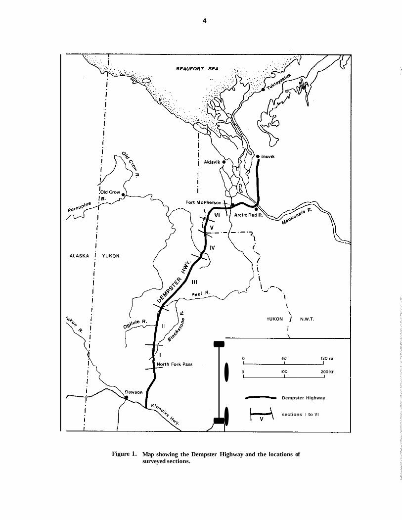
Figure 1. Map showing the Dempster Highway and the locations of surveyed sections.

5
In trodwction
In July 1979, Foothills Pipe Lines (Yukon) Ltd. made an application to the Government of Can- ada to construct and operate the 1200 km Dempster Lateral gas pipeline from the Mac- kenzie Delta, Northwest Territories (N.W.T.). to a point near Whitehorse, Yukon Territory (Y.T.). The implementation of these plans will incur an engineering effort as well as measures to secure the integrity of the pipeline and to prevent or mitigate impacts on the environment.
This report is concerned with the vegetation and soils along the Dempster Highway portion of the pipeline, from west of Peel River. N.W.T., to North Fork Pass, Y.T. (Fig. 1). In this area, the general regional flora and ecology have been relatively well documented (Welsh 1974: Oswald and Senyk 1977: Roberts-Pichette 1972); how- ever, detailed information was not uniformly available in part owing to the fact that construc- tion of the Dempster Highway was not com- pleted until 1979 (Macleod 1979).
In the Mackenzie Valley, north of the survey area, terrain and vegetation aspects were stud- ied in connection with northern oil and gas development (Forest Management Institute 1974 ; Zoltai and Pettapiece 1973: Zoltai and Tarnocai 1974 ; Hettinger, Janz and Wein 1973, and references therein). In the southern ranges of the Ogilvie Mountains, north of North Fork Pass, Richer (1968) provided use- ful information with regard to quaternary geol- ogy, including botanical criteria, which he
applied to explain the chronology of morainal sequence. Hulten (1966) and Porsild (1967) con- ducted some studies of indigenous plants in the same area. Schultz International Ltd. (1972). Foothills (1979) and Vaartnou (1979) provided information on broad vegetation grouping. South of North Fork Pass, the vegetation is sim- ilar to that of the Boreal Forest Region (Rowe 1972) and has been described (See references in Orloci and Stanek 1980; Stanek 1980).
In 1979, the Canadian Wildlife Service, in coop- eration with the Yukon Territorial Government, initiated a project to document the impact of the Dempster Highway on migrating and winter- ing caribou. The results are not yet available.
The objectives of this report coincide with the “Scope of Work” stipulated by Foothills in their Purchase Requisition; namely, “A vegetation- soil survey will be undertaken by the Canadian Forestry Service to provide information for future revegetation programs and biophysical inventory along the Dempster Lateral Gas Pipe- line route. The survey will identify representa- tive vegetation communities to determine their characteristic soil properties. The approximate areal extent of each community type will be determined from available imagery.”
This report deals with vegetation types. The report on characteristic soil properties and any forthcoming maps will be contained in subse- quent publications of the same series.

6
Methods
The survey was undertaken during the latter part of August and the beginning of September in 1979 for a distance of 450 km along the Dempster Highway (Fig. 1) from North Fork Pass, Y.T. (lat 64"30'N, long 138" 15'W). to west of Peel River, N.W.T. (67"22'N, 134"55'W). The sampling design utilizes stratification by six sec- tions (Table 1, Fig.1) and ten vegetation domi- nance types (Table 2).
Sections I, 11, 111, IV, V and VI correspond to Ecoregions 16, 17, 18, 20, 22 and 21 respec- tively, of Oswald and Senyk 1977. In this report, Sections IV, V and VI were named differently than the Ecoregions to emphasize the geo- graphically limited area of this survey (Table 1).
In total, 100 plots were surveyed. The distribu- tion per section is determined according to the estimated length of highway traversed by each and the availability of replicates (preferably three) per representative physiognomic group (Table 2). The plots, 20 m in radius, are located not far from the highway in uniform, apparently undisturbed stands. Four subplots per plot were surveyed.
For each species present, the plot cover/abun- dance (C/A) values, which had been coded on a scale from 1-5, were converted to percentage midpoints as follows:
CodeC/A Range Midpoint 1 abundant, low cover 1-10% 5.5% 2 very abundant,
low cover 11-25% 18% 3 highcover, 26-50% 38% 4 highcover, 51-75% 63% 5 highcover, 76.100% 88%
The method of data analysis incorporates a clustering procedure using the sum-of-squares agglomeration. The method involves successive passes through a matrix of relative distances between subsets of plots, determining overall similarities between subsets, and amalgamating those pairs of subsets which are most similar. Orloci (in Stanek and Orloci 1973) published a computer program in BASIC. This program was translated into FORTRAN IV and converted to execute larger analyses on a PDP-11/45 mini- computer.
The results of the computer clustering on coverlabundance values were used to produce dendrograms, maps of the paths through which plots were agglomerated to form increasingly larger clusters. Timing and order of clustering were given by the within-cluster sum of squares. For each analysis, a within-cluster sum of squares value was chosen as a cut-off point for terminating clustering, this choice being based on the meaningfulness of the resultant clusters.
Within each section, groups were identified as clusters of plots which have been found to be similar and which are represented by a single stem of a dendrogram at the within-sum-of- squares cut-off point. Because of an apparent similarity among the 32 groups in the sections, further clustering of similar groups into vegeta- tion types was done using species values, a quantity which would give equal consideration to the presence/absence of a species within a group and to its C/A value and permit a more meaningful interpretation of the group relation- ships.
Species Value = SV = FV,, x FV, = PW(1 - PO) CW(1- CO)
= a species fidelity value based on its presence in plots = PW(1 - PO)
= a species fidelity value based on its plot cover in plots which have the species present
FV,
FV,
= CW( 1 - CO) = Presence within = the proportion of
plots with a given species present, within a given group
PO = Presence outside = the proportion of plots with a given species present, outside a given group but within a larger class
= Mean C/A of plots with a given spe- cies present, within a given group
= Mean C/A of plots with a given spe- cies present, outside a given group but within a larger class
PW
CW
CO
The fidelity value (FV,) (Orloci and Stanek 1980), weighs the frequency of a species' pres- ence inversely to its frequency of presence else- where. An analogous fidelity value (FV,) was
7
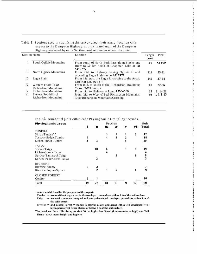
Table 1. Sections used in stratifying t h e survey area, their name , location with respect to t h e Dempster Highway, approximate length of t h e Dempster Highway traversed by e a c h Section, a n d sequences of sample plots. . .. -
Section Name Location
I South Ogilvie Mountains
II North Ogilvie Mountains
111 Eagle Plain
N Western Foothills of Richardson Mountains
V Richardson Mountains VI Eastern Foothills of
Richardson Mountains
.- - From south of North Fork Pass along Blackstone River to 10 km north of Chapman Lake at lat 64"57" From ibid. to Highway leaving Ogilvie R. and ascending Eagle Plains a t lat 65"43'N From ihid. past the Eagle R. crossing to the Arctic Circle a t Lat. 66'33" From ibid. to south of the Richardson Mountains Yukon/NWT border From ibid. to Highway at Long. 135"45'W From ibid. to West of Peel Richardson Mountains River Richardson Mountains Crossing
Length Plots (km)
60 82-100
112 55-81
145 37-54
60 22-36
25 8. 14-21 50 1-7.9-13
~
Table 2. Number of plots within each Physiognomic Group * by Sections. Physiognomic Group
TUNDRA: Shrub Tundra" Tussock-Sedge Tundra 8 Lichen-Shrub Tundra 3
TAIGA: Spruce Taiga Lichen-Spruce Taiga Spruce-Tamarack Taiga Spruce-Paper Birch Taiga
RIVERINE Riverine Willow 5 Riverine Poplar-Spruce
CLOSED FOREST 3 Conifer
Total 19
I - __
.~ ~
Section II 111 Iv
3 2 4 3
3
6 4
10
5 3
2 2 1 5
- I
27 18 15 __
v VI
1 6 3 4
1 2
3
1
9 12
Sub Total
12 18 10
19 4 8 3
__
7 9
10 100 ___
'named and defined for the purposes of this report: Tundra - areas without vegetation in the tree-layer. permafrost urithin 1 m of the soil surface. Taiga - areas with an open canopied and poorly developed tree-layer, permafrost within 1 m of
Riverine - and Closed Forest - stands in alluvial plains and areas with a well developed tree-
"Included are: Dwarf Shrub (up to abut 30 cm high), Low Shrub (knee to waist - high) and Tall
the soil surface.
layer, permafrost either absent or below I m of the soil surface.
Shrub (about man's height and higher).

1oooc
1000
500
0
8
derived based on CIA. To make this C/A fidel- ity value independent of presence/absence, data were used from those plots that had the given species present (only species with PW20.5 were included in the analysis). For each vegetation type, the list of characteristic species is composed of species with PW20.5 and SV20.01. The name of the vegetation type is composed of the names of the three charac- teristic species with the greatest SV.
The survey for the environmental factors was conducted by Pacific Forest Research Centre at the time of the vegetation survey and on the same plots. Where applicable, the information is based on four random records per plot. Depth to frozen ground up to 1 metre was measured, soil conditions permitting. In this report, per- mafrost is termed frozen ground persisting into September, in a layer that could not be pene- trated by hand drilling 10 cm deep. The survey measurements were compared with those of drill-hole records (Klohn Leonoff 1978).
Soils are classified according to Canada Soil
Survey Committee (1978) as determined on existing natural and artificial profile exposures and soil auger drillings. The organic and min- eral horizons were sampled to a depth of 50 cm, soil texture and permafrost permitting, using a soil auger. Soil pH of organic and mineral soils is determined in a 1:l slurry of 0.01 M CaClz solution and soil composite of four random sub- samples per plot.
Nomenclature of vascular species is according to Hulten (1968) and Welsh (1974); non-vascu- lar nomenclature is primarily according to Crum et al. (1973) and Hale and Culberson (1970). Only characteristic species are listed under each vegetation type: complete lists of species are kept at PFRC.
The vegetation data collection consisted only of the most common species of trees, shrubs, herbs and grasses. Moss and lichen C/A, also recorded, were not identified by species. The C/ A values for both were included in the data matrix as two of the 90 species identified.
r ? I (I i i
14
I
Figure 2
1
Dendrogram showing clustering of 32 groups to produce 20 vegetation types. Dendrogram is based on species values for each species present in a group with PW >0.50 as the data, and sum-of-squares agglommeration as the method of analysis. The types are identified by numbers 1 to 20 along the x axis. Numbers in the y axis indicate sum- of- squares.
9
Results As a result of the available vegetational infor- mation, the anticipated sectional heterogeneity did not materialize. The clustering of plots within individual sections on species cover abundance values resulted in 32 specific groups, but indications were that similarities between these groups occurred throughout the surveyed area. Therefore, clustering of the 32 groups, on
the species values of species with greater than 50% presence within the group was carried out. Figure 2 shows the resulting dendrogram, which identifies 20 vegetation types. The descriptions of these 20 types follow. However, the reader should bear in mind that the results must be considered preliminary and as a step -toward .future surveys.
A. Descriptions of Vegetation Types.
Type 1 - Eriophorum vaginatum - Ledum palustre - Betula nana
Surveyed were 18 plots in Section (plot num- ber): 1 (82,83,84,86,87,93,94,95); 3 (38,49, 52,53), 4 (22,23,30); 5 (8,14,17).
Characteristic species mean F V p SV cover %
Eriophorum vaginatum 41.7 0.62 0.24 Ledum palustre 22.5 0.32 0.06 Betula nana 6.1 0.56 0.05 Carex sp. 23.5 0.20 0.04 Rubus chamaemorus 6.8 0.48 0.04 Lichen sp. 15.0 0.22 0.03 Vaccinium vitis-idaea 11.2 0.12 0.02 Betula glandulosa 4.9 0.21 0.01 Empetrum nigrum 2.9 0.23 0.01 This type includes what may be described as Tussock-Sedge Tundra. In general, this type occurs on permafrost, with frozen soil occurring mainly a t depths ranging from 30-60 cm. It is poorly developed along streams and southfac- ing slopes. Occasional Regosolic and Brunisolic Turbic Cryosols are found soils are predomi- nantly Gleysolic Turbic Cryosols, and are characteristically poorly drained. Above the permafrost, there is usually a thin clay-textured mineral layer and a n organic layer ranging in thickness from 5-40 cm. The pH of mineral soil ranges from 3.3 to 4.9 and that of the organic layer from 3.0 to 5.1.
This type, sampled in the South Ogilvie Moun-
tains, which is similar in composition to the understory of the “Picea mariana-Aulacom- nium palustre” (see descriptions under Type 91. The type has a microtopography with tussocks comprising about 30 to 40% of the ground cover and is common on polygon fields and low gradi- ent slopes and swells: low shrubs including birch grow around the tussocks to a height of 40 to 70 cm; moss cover is continuous.
In the Richardson mountains, poorly drained areas support vegetation dominated by Carex, Eriophorum and mainly Sphagnum, a combina- tion which comparable to the “Seasonal Ortho- phyll Meadow Formation” described by Hett- inger et al. (1973) for the Richardson Noun- tains.
In the Eagle Plains, sedge tussocks occur fre- quently, although ericaceous shrubs and lichens are also usually present. The tussocks are fre- quently associated with hummocks which exhibit microsite differences, with Drepano- cladus occupying the depressions and Sphagna the tops.
In the Western Foothills of the Richardson Mountains, sedge tussocks also occur on hum- mocky terrain. The hummocks contain organic layers as thick as 45 cm, occasionally underlain by a thin layer of unfrozen mineral soil. Mineral soil is frequently found in the depressions amid the hummocks. Sedge tussocks occur also in terrain with non-sorted circles composed of fria- ble clay with occasional stones.
Comparable to Type 1 are: Richer’s (1968)

10
Figure 3. Tussock-Sedge Tundra (Type 1 in Section 4). In the back- ground are the Richardson Mountains (Photo E.T. Oswald).
Figure 4. Dwarf Shrub Tundra with polygons and non-sorted circles (Type 2 in Section 3) on gently sloping terrain of the Eagle Plains.

11
“Shrub-Tussock community” investigated in the South Ogilwies, Viereck‘s (1966) “Low Shrub- Sedge Tussock Moss Tundra” in the Mt. McKin- ley region, Drew and Shanks’ (1965) “Upland Tussock Tundra” in the Firth River region, Kra- jina’s (1975) associations Betula (glandulosae) - Chamaemoretum or Betulo (glandulosae) - Eriophoretum waginati described for the Subal- pine Tundra Zone of the Richardson Mountains, and Dyrness and Vierecks’ (1979) “Sedge Tus- sock - Mixed shrub”.
Type 2 -Arctostaphylos alpina - Eriophorum vaginatum - Ledum palustre Surveyed were 3 plots in Section (plot number): 3 (37,48,50).
Characteristic species
Arctostaphylos alpina Eriophorum vaginatum Ledum palustre Carex sp. Arctostaphylos rubra Vaccinium uliginosum Lichen sp. Empetrum nigrum Betula glandulosa Rubus chamaemorus Salix pulchra Petasites frigidus Calamagrostis
canadensis Vaccinium witis-idaea
mean FV, cower %
13.4 0.74 16.5 0.34 21.5 0.27 29.7 0.17
6.8 0.40 9.3 0.39
18.8 0.21 8.6 0.39
10.5 0.21 5.8 0.34 9.7 0.32 3.7 0.72
2.8 0.66 12.4 0.12
sv
0.10 0.07 0.05 0.04 0.04 0.03 0.03 0.03 0.03 0.03 0.03 0.03
0.02 0.02
Arctagrostis latifolia 2.3 0.43 0.01 Picea mariana 1.8 0.45 0.01 This is a Dwarf Shrub Tundra with polygons and/or hummocks on flat to gently sloping ter- rain of the Eagle Plains. Picea mariana may occur irregularly scattered. Generally soils are sandy clays with stones with an organic horizon up to 10 cm. Gleying is concentrated above the permafrost layer, which occurs at 39 cm in organic soil and up to 55 cm deep in mineral soil. Regosolic and Brunisolic Turbic Cyosols are common. Occasionally, rocky soils with stone circles occur. The pH range of the organic soil is 3.4 to 3.9 and of the mineral soils it is 3.8 to 3.9.
___
Type 3 - Salix reticulata - Betula nana - Rubus chamaemorus Surveyed was plot 15 in Section 5.
Characteristic species mean FV, SV
Salix reticulata 31.1 0.74 0.22 Betula nana 14.9 0.83 0.11 Rubus chamaemorus 16.8 0.51 0.08 Vaccinium witis-idaea 24.9 0.16 0.03 Ledum palustre 14.9 0.26 0.03 Empetrum nigrum 8.6 0.38 0.03 Arctagrostis latifolia 2.7 0.64 0.02 Eriophorum vaginatum 4.1 0.52 0.02 Betula glandulosa 5.5 0.32 0.02 Rumex crispus 1.4 0.95 0.01 The Low Shrub Tundra is characterized by a closed ground cover of Polytrichum, Sphagna and Hylocomium splendens, widely spaced low shrubs and the absence of trees or tall shrubs. This type occupies imperfectly drained solifluction terraces on most of the silt mantled slopes in hummocky terrain in the Richardson Mountains. Permafrost depth ranges from 30-45 cm. Humus depth varies from 5 cm on top of hummocks to 20-25 cm at their side. Soil is Gleysolic Turbic Cryosol with occasional weak mottling and has a pH of 3.4 and 3.6 in the organic and mineral soil, respectively. This type is comparable to the one described for the Rich- ardson Mountains by Hettinger et al. (1973) as “Open Deciduous Orthophyll Scrub Forma- tion”.
cower %
Type 4 - Alnus crispa - Arctostaphylos alpina. - Vaccinium uliginosum Surveyed were plots 34 and 36 in Section 4
Characteristic species mean FV, SV
Alnus crispa 28.6 0.79 0.20 cower %
Arctostaphylos alpina Vaccinium uliginosum Betula glandulosa Ledum palustre Eriophorum vaginatum Carex sp. Lichen sp. Arctostaphylos rubra Salix reticulata Salix pulchra
14.2 0.38 0.10 28.0 0.39 0.10 22.4 0.33 0.06 16.8 0.27 0.04 8.6 0.52 0.04
22.4 0.16 0.03 12.7 0.20 0.02 3.4 0.60 0.02 2.7 0.37 0.02 5.5 0.32 0.02

Figure 5. Landscape just north of North Fork Pass (Section 1). In the foreground, natural revegetation of area disturbed by high- way construction; in the middle ground, the valley of the Blackstone River (barely visible is a traverse of an aban- doned highway right-of-way) showing a complex melange of tundra types (Type 2, Type 3, Type 1 plus several possible types or variants not cowered by this survey); in the back- ground, the Ogilvie Mountains which were not included io the survey.
Figure6. Low Shrub Tundra (Type 5 in Section 6) in the eastern foothills of the Richardson Mountains.

13
Tall Shrub Tundra develops on gently sloping hummocky terrain with cryoturbation (non- sorted circles) and solifluction, in the Western Foothills of the Richardson Mountains. Dense alder and willow thickets with a ground cover of sedge tussocks characterize this type. Hettinger, Janz and Wein (1973) record the presence of alder and willow associated with sedge tussocks in the warmer areas of this region. Soils are Regosolic Turbic Cryosols composed of sandy clay with stones. The organic layer is shallow (about 5 cm), except under Sphagnum, where it becomes deeper. In portions, non sorted circles are prominent and the humus layer is discontin- uous. The pH of the organic layer ranges from 3.4 to 3.7: the pH of the mineral layer is about 3.7. Permafrost depth varies from 75 to 150 cm in the locations sampled.
Type 5 - Rubus chamaemorus - Betula glandulosa - Vaccinium uliginosum Surveyed were plots 3, 4, 5, 6, 7 and 12 in Sec- tion 6
Characteristic species
Rubus chamaemorus Betula glandulosa Vaccinium uliginosum Alnus crispa Ledum groenlandicum Petasites sagittatus Ledum palustre Vaccinium vitis-idaea Spiraea beauverdiana Empetrum nigrum Lichen sp. Eriophorum vaginatum Eouisetum arvense
mean FV, SV cover %
16.3 0.43 0.08 23.3 0.34 0.07 13.9 0.40 0.05 6.4 0.53 0.05 6.7 0.56 0.04 4.2 0.78 0.04
14.4 0.28 0.03 21.4 0.17 0.03
4.1 0.64 0.03 7.5 0.33 0.03
10.5 0.21 0.02 3.3 0.44 0.01 2.3 0.35 0.01
This tundra type is composed primarily of low shrubs with irregularly scattered tall alder. It was observed on 5-10 degree south and south- west slopes on hummocky terrain in the Eastern Foothills of the Richardson Mountains. The pro- nounced micro-relief of hummocks creates different environments within very short dis- tances, having a profound effect on vegetation distribution and growth. The tops of the hum- mocks are from 30 to 60 cm above the moss- rich inter-hummock troughs. In well-drained areas, the hummocks may support ericaceous shrubs and liverworts growing in an organic
layer from 1-25 cm deep, under which is mot- tled loamy soil. Many hummock tops, however, are completely devoid of vegetation, exposing the bare mineral soil. In this type, permafrost underlies the hummocky terrain at depths from 60-75 cm. Commonly found at the permafrost contact zone is a gleyed sticky clay. In the inter- hummock troughs a layer of dark soil, high in organic content, subtended by gleyed coarse soil material with stones is prevalent. Gleysolic and Brunisolic Static or Turbic Cryosols are com- mon. The pH of the organic soil ranges from 2.9 to 3.6 and of the mineral soil from 3.3 to 3.8.
Type 6 - Lichen sp. - Betula glandulosa - Ledum palustre Surveyed were 6 plots in Section (plot number): 1 (90.97.98): 2 (72,75,81).
Characteristic species mean N, SV
Lichen sp. 43.0 0.21 0.08 Betula glandulosa 0.7 0.28 0.05 Ledum palustre 22.3 0.28 0.05 Vaccinium uliginosum 7.3 0.19 0.02 Empetrum nigrum 5.7 0.40 0.02 Salix pulchra 7.0 0.33 0.02 Vaccinium vitis-idaea 9.8 0.17 0.02 Arctostaphylos rubra 2.3 0.40 0.01 Arctagrostis latifolia 1.8 0.32 0.01 Petasites frigidus 1.6 0.48 0.01
This is Lichen-Shrub “Alpine” Tundra: stunted spruce (P. glauca and/or P. mariana) may occur. It occupies open, steep, north facing slopes in the North and South Ogilvie Moun- tains. The slopes exhibit typical step and dike formations created by solifluction. Richer (1968) verifies the presence of these soliflucted slopes in the North Fork Pass region of the Ogil- vie Mountains. This type is characterized by the presence of Cerastium beeringianum which, although infrequent in the areas sampled, is common on open slopes in the Yukon (Welsh 1974). Soils are Gleysolic Static Cryosols, with a n organic layer ranging from 3-20 cm under- lain by a shallow gleyed layer of mineral soil over permafrost. The active layer ranges from 30 to 55 cm. Depending on thickness of the organic layer, the pH ranges from 3.5 to 5.9: pH of the mineral layer is from 4.1 to 5.9. Under dry conditions, on rocky outcrops and rubbly talus, often windblown and free of snow during part of the winter, a comparable type identified
cover %
~

14
Figure 7. Lichen-Shrub Tundra (similar to Type 8) found on steeper exposed slopes: the example stems from the southern expo- sures in the vicinity of the North Fork Pass, Ogilvie Moun- tains. (Photo E.T. Oswald).
by Nimis (personal comm.) as “Lichenes-Hiero- Chloe alpina” occurs. Vegetation cover is com- posed primarily of lichens. The specific floristic composition is as follows: Hierochloe alpina, Empetrum nigrum, Vaccinium vitis-idaea, Alec- toria ochroleuca, Cetraria richardsonii, Dactyl- ina madreporiformis, D. arctica, Nephroma arcticum, Cetraria nivalis, C. cucullata, C. islandica, Cladonia mitis, C. rangiferina, C. arbuscula, C. coccifera, C. uncialis. C. alpestris, C. amaurocraea.
Type 7 - Lichenes - Cassiope tetragona - Petasites sagittatus Surveyed was plot 16 in Section 5 Characteristic species mean FV, SV
cover %
Lichen sp. 75.5 0.20 0.13 Cassiope tetragona 5.5 0.95 0.05 Petasites sagittatus 5.5 0.90 0.05 Betula nana 5.5 0.83 0.04 Arctostaphylos alpina 5.5 0.77 0.04 Salix reticulata 5.5 0.74 0.04 Arctagrostis latifolia 4.1 0.64 0.03 Empetrum nigrum 5.5 0.38 0.02 Vaccinium uliginosum 5.5 0.38 0.02 Ledum palustre 5.5 0.26 0.01 This Lichen-Shrub Tundra exists on slopes with a northern exposure in the Richardson Moun-
__
‘I

~
15
tains. Dominant are lichens and Cassiope tetra- gona, with important secondary species includ- ing Salix reticulata and Empetrum nigrum. While mosses are present, lichens are most abundant, with no particular species predomi- nant. A pattern of nonsorted circles and/or sorted circles may exist on the upper slopes, while solifluction dikes occurs on the lower slopes. Soils are Gleysolic Turbic Cryosols. Por- tions of the ground surface may be exposed mineral soil; organic horizons are often buried. Permafrost depth varies from 60 cm to more than 100 cm (deepest in centres of circles). The pH of the mineral soils is 3.6 and of the organic soil 3.4.
Krajina (1963) has listed several “late-snow-lie” associations from the flanks of the Richardson Mountains, of which his “Cassiope tetragona - Hylocomium splendens var. alaskanum - (Dryas punctata) Association” of the Alpine Tundra Zone resembles the type described here. Richer (1968) describes a “Late-Snow-lie Com- munity” characterized by Cassiope tetragona, which is comparable in species compositon to this type. Hettinger, Janz and Wein (1973) verify the presence of Cassiope tetragona, lichen and dwarf willow on well-drained solifluction slopes in the Richardson Mountains.
Type 8 - Betula glandulosa - Lichen sp. - Vaccinium uliginosum Surveved were dots 18.19.21 in Section 5
Characteristic species mean FV, SV
Betula glandulosa 43.4 0.33 0.13 Lichen sp. 22.2 0.21 0.04 Vaccinium uliginosum 8.3 0.39 0.03 Salix reticulata 4.1 0.50 0.03 Petasites frigidus 3.8 0.47 0.03 Empetrum nigrum 6.1 0.39 0.02 Festuca altaica 2.3 0.58 0.02 Loiseleuria procumbens 1.8 0.66 0.02 Calamagrostis
canadensis 2.3 0.43 0.01 This is a Lichen Low Shrub Tundra, in which Betula glandulosa and large patches of lichens and grasses are abundant. No trees or tall shrubs are present. This type is observed on moderate to steep southern, southeastern and northwestern slopes in the Richardson Moun-
cover %
tains. Soil is extremely stony, 20-25 cm deep, overlying bedrock of coarse plated schist. Per- mafrost depth is estimated to range from 60- 150 cm. The organic layer, mainly of fibrous material, is 1-4 cm thick and covers only about half the ground surface: the rest is exposed min- eral soil.
The pH of the organic soil ranges from 3.2 to 3.9 and of the mineral soil from 3.4 to 3.9. Depending on depths of the active layer, the prevailing subgroups are lithic phases of either Gleyed Dystric Brunisols, Orthic Regosols and Orthic Dystric Brunisols or Brunisolic Static Cryosols.
Type 9 - Picea mariana - Eriophorum vaginatum - Carex sp. Surveyed were plots 60, 62, 65, 66, 69, 70, 77 and 79 in Section 2
Characteristic species mean FV, SV
Picea mariana 13.6 0.53 0.08 Eriophorum vaginatum 10.8 0.48 0.05 Carex sp. 29.7 0.17 0.05 Betula glandulosa 13.0 0.35 0.04 Ledum palustre 12.6 0.28 0.03 Vaccinium uliginosum 7.2 0.35 0.03 Ledum groenlandicum 4.0 0.50 0.03 Oxycoccus microcarpus 2.2 0.72 0.02 Salix reticulata 2.7 0.38 0.02 Andromeda polifolia 2.1 0.58 0.02 Salix pulchra 6.3 0.29 0.02 Arctostaphylos rubra 3.0 0.38 0.02 Lichen sp. 8.6 0.22 0.02 Vaccinium vitis-idaea 8.8 0.17 0.01 Structurally, this type is a n open, treed-bog-like Spruce Taiga dominated by Picea mariana and a tussocky microtopography, of Eriophorum vaginatum. It closely resembles the open-cano- pied Picea - Ledum - Aulacomnium Type (Orloci and Stanek 1980 Stanek 1980) and is comparable to the moss-rich “Picea mariana - Aulacomnium palustre” described by Nimis (personal comm.). It is observed on mainly flat terrain, often with hummocks, in the North Ogilvie Mountains as well as along the Demp- ster Highway south of North Fork Pass. Per- mafrost is always present, with depths ranging from 33 to 55 cm. Soils are mainly Terric-Mesic,
cover %

Mesic and Humic Organic Cryosols with more than 40 cm of tundra peat and Gleysolic Static Cryosols in places with less than 40 cm of organic surface horizons. The pH of the organic soil ranges from 3.4 to 6.2 and of the mineral soil from 3.8 to 6.4.
A sub-type dominated by Sphagna is recogniz- able on acid parent material with a shallow active layer. Micro-units of vegetation exist; for example, within this type, tied to microsites, a unit, characterized by fruticose lichens, occurrs in dry habitats on hummocks, or a Drepano- cladus vernicosus unit persists under water in depressions among hummocks.
Two distinct phases are also recognizable. The first, characterized by the presence of Andromeda polifolia, occupies wet, silty clays on flat terrain, where drainage is usually impeded. The second phase, with high sedge cover, is observed on the fringe of marsh areas or river banks, where conditions are extremely wet.
The floristic composition of the “Picea mariana - Aulacomnium palustre” community as described by Nimis (personal comm.) is as fol- lows:
Picea mariana, Potentilla fruticosa, Arctosta- phylos rubra, Ledum decumbens, Andromeda polifolia, Salix reticulata, S. glauca, Vaccinium uliginosum ssp. typicum and ssp. microphyllum, Dryas intergrifolia, Rhododendron lapponicum, Salix myrtillifolia. Betula glandulosa, B. nana, Rubus chamaemorus, Oxycoccus microcarpus, Empetrum nigrum, Carex consimilis C. capil- laris. C. scirpoidea, C. membranacea, C. micro- chaeta, Eriophorum vaginatum, Equisetum arvense, E. sylvaticum, Tofieldia pusilla, Sene- cio lugens, Pedicularis labradorica, Equisetum scirpoides, E. variegatum, Petasites hyper- boreus. Polygonum viviparum, Rumex arcticus, Senecio atropurpureus. Lycopodium alpinum, Selaginella selaginoides, Aulacomnium palus- tre, Drepanocladus vernicosus, Rhytidium rugo- sum, Sphagna, Dactylina arctica. Cladonia mitis, C. rangiferina, Peltigera aphthosa, P. leu- cophlebia, Cladonia arbuscula, C. alpestris, C. amaurocraea, Cetraria nivalis. C. cucullata, Thamnolia subuliformis. Cladonia deformis, Nephroma arcticum, Icmadophyla ericetorum (the latter only in sub-association sphagneto- sum).
Type 10 - Ledum groenlandicum - Picea mariana - Betula papyrifera Surveyed were 5 plots; namely, 47.51 and 54 in Section 3 and plots 1 and 2 in Section 6
Characteristic species mean FV, SV
Ledum groenlandicum 24.9 0.67 0.16 Betula papyrifera 7.7 0.58 0.07 Picea mariana 10.0 0.71 0.06 Vaccinium vitis-idaea 26.9 0.17 0.04 Spiraea beauverdiana 3.3 0.61 0.02 Rosa acicularis 3.0 0.55 0.02 Betula glandulosa 5.8 0.26 0.02 Calamagrostis
canadensis 1.9 0.39 0.01 Rubus chamaemorous 2.2 0.30 0.01
Open Spruce Taiga, is mainly found on gentle slopes in the Eagle Plains and Eastern Foothills of the Richardson Mountains. The trees are gen- erally clumped, apparently of layer origin, and are surrounded by low shrubs. In the Eastern Foothills of the Richardson Mountains, hum- mocky terrain governs vegetation distribution and growth in this type. Less than 10% of the trees grow on hummock tops, the rest being equally divided among the sides of the hum- mocks and inter-hummock troughs (Zoltai and Pettapiece, 1974 ). Spruce is often tilted and leaning away from the hummocks (Zoltai and Tarnocai 1974). Ericaceous shrubs and liverworts dominate the tops of the hummocks and Sphagnum cuspidatum and purpureum dominate the inter-hummock troughs. Moss cover in this type is high, with Hylocomium splendens and Sphagna being most common. Soils are Gleysolic Turbic Cryosols with 10-30 cm of fibrous tundra peat, underlain by a layer of organic rich silty clay. Occasionally, there are signs of very active cryotqrbation. Mineral soil consists of gleyed, compacted, non-plastic silty clay. The pH of the organic soil ranges from 3.2 to 4.0 and of the mineral soil from 3.2 to 4.8. Permafrost depth ranges from 45-120 cm in the communities sampled.
-.
cover % __
- ~ _ _ ~ ~ _ _ ~ ~

Figure 8. Open, treed-bog-like Spruce Taiga (Type 9, Section 2). The trees are over 100 years old. The site is wet; the active layer is relatively shallow.
Figure 9. Open treed-bog-like Spruce Taiga (Type 9, Section 2) after a surface fire about a decade ago. Before fire. the stand looked similar to the one in Figure 8. The fire exposed the typical microtopography of hummocks and tussocks.

Figure 10. Open Spruce Taiga (Type 10, Section 3) extensively occur. ring in the Eagle Plains.
Figure 11. Relatively open Spruce - Tall Shrub Taiga (Type 11, Sec- tion 3). Black and white spruce may occur together.
19
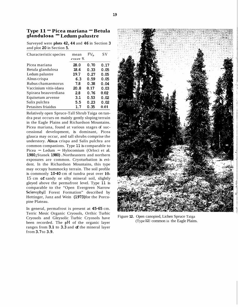
Type 11 - Picea mariana - Betula giandulosa - Ledum palustre Surveyed were plots 42, 44 and 46 in Section 3 and plot 20 in Section 5. Characteristic species mean FV, SV
rover %
Picea mariana Betula glandulosa Ledum palustre Alnus crispa Rubus chamaemorus Vaccinium vitis-idaea Spiraea beauverdiana Equisetum arvense Salix pulchra Petasites friaidus
28.0 18.6 19.7 6.3 7.8 20.8 2.8 3.1 5.5 1.7
0.70 0.33 0.27 0.59 0.38 0.17 0.76 0.53 0.23 0.35
0.17 0.05 0.05 0.05 0.04 0.03 0.02 0.02 0.02 m i
Relatively open Spruce-Tall Shrub Taiga on tun- dra peat occurs on mainly gently sloping terrain in the Eagle Plains and Richardson Mountains. Picea mariana, found at various stages of suc- cessional development, is dominant, Picea glauca may occur, and tall shrubs comprise the understory. Anus crispa and Salix pulchra are common companions. Type 11 is comparable to Picea - Ledum - Hylocomium (Orloci et al. 1980; Stanek 1980). Northeastern and northern exposures are common. Cryoturbation is evi- dent. In the Richardson Mountains, this type may occupy hummocky terrain. The soil profile is commonly 10-40 cm of tundra peat over 10- 15 cm of sandy or silty mineral soil, slightly gleyed above the permafrost level. Type 11 is comparable to the “Open Evergreen Narrow Sclerophyll Forest Formation” described by Hettinger, Janz and Wein (1973) for the Porcu- pine Plateau.
In general, permafrost is present at 45-65 cm. Terric Mesic Organic Cryosols, Orthic Turbic Cryosols and Gleysolic Turbic Cryosols have been recorded. The pH of the organic layer ranges from 3.1 to 3.3 and of the mineral layer from 3.7 to 3.9.
Figure 12. Open canopied, Lichen Spruce Taiga (Type 12) common in the Eagle Plains.

Type 12 - Picea mariana - Lichenes - Ledum palustre Surveyed were plots 39.40,43,45 in Section 3
Characteristic species mean FV, SV
Picea mariana 32.1 0.70 0.19 Lichen sp. 63.3 0.21 0.11 Ledum palustre 16.4 0.27 0.04 Vaccinium vitis-idaea 23.6 0.12 0.03 Liverwort sp. 2.2 0.49 0.02 Spiraea beauverdiana 2.8 0.52 0.02 Vaccinium uliginosum 4.4 0.40 0.02 Rosa acicularis 2.4 0.69 0.02 Equisetum arvense 2.1 0.35 0.01
4.2 0.33 0.01 Betula glandulosa
This open canopied, Lichen Spruce Taiga on flat terrain or gently sloping western or southwestern exposures was found in the Eagle Plains. The trees are characterized by a short, ragged growth form. Lichens dominate in the understory. The organic layer is from 3-5 cm deep; the mineral soils consist usually of a deep layer of sandy soil with mottling or strong gley- ing, subtended by a layer of wet clay above platy stones. Generally, permafrost is found at depths
cover %
__
ranging from 100 to 150 cm. Soils are com- monly Gleyed Dystric Brunisols. The pH of the organic layer ranges from 2.8 to 3.1 and of the mineral layer from 3.2 to 3.8.
Type 13 - Picea mariana - Vaccinium uliginosum - Larix laricina Surveyed were 8 plots; namely, plots 9,10, 11 in Section 6 and plots 24, 25, 27, 28 and 32 in Section 4
Characteristic species mean RIP SV rnver 9h
Picea mariana Vaccinium uliginosum Larix laricina Betula glandulosa Rubus chamaemorus Empetrum nigrum Lichen sp. Spiraea beauverdiana Ledum palustre Arctagrostis latifolia Salix pulchra Carex sp. Ledum groenlandicum
11.1 0.63 0.07 15.9 0.41 0.06 8.1 0.60 0.07
12.0 0.35 0.04 7.2 0.47 0.04 8.2 0.41 0.03
13.3 0 2 2 0.02 3.0 0.38 0.02 9.2 0.24 0.02 2.9 0.59 0.02 6.5 0.24 0.02
11.2 0.14 0.02 2.6 0.33 0.02
20
Vaccinium vitis-idaea 9.6 0.17 0.01 Arctostaphylos alpina 1.8 0.39 0.01
This is open Black Spruce Tamarack Taiga, with a closed shrub understory. This type occurs prominently in the Eastern Foothills of the Rich- ardson Mountains on gentle slopes with poor drainage. Apparently the dominance and den- sity of the tree stratum is dependent on the fire history (Hettinger, et al. 1973). In the Eastern Foothills, this type is often found on hummocky terrain with 15-20 cm of organic soil over 25-30 cm of unfrozen mineral soil above permafrost. In the Western Foothills, organic layers are gen- erally deeper, ranging from 10-45 cm over fine textured clays and silt, often heavily gleyed. Soil mottling, evidence of fire in the mineral layers, unsorted circles and polygons have been found on these sites. Permafrost is present a t depths ranging from 33 to 65 cm (Klohn Leonoff Con- sultants Ltd. 1977). The soils are of the Cryo- solic order.
Type 14 - Picea glauca - Equisetum arvense - Lupinus arctic u s Surveyed were 9 plots: namely, plots 92,99,100 in Section 1 and plots 59, 61,63, 67,68, 78 and 80 in Section 2.
Characteristic species mean FV,, SV cnver 9h
Picea glauca 31.8 0.78 0.22 Equisetum arvense 7.4 0.36 0.05 Lupinus arcticus 4.7 0.81. 0.04 Arctostaphylos rubra 6.2 0.51 0.04 Ledum groenlandicum 5.0 0.40 0.03 Salix pulchra 10.8 0.30 0.03 Shepherdia canadensis 2.2 0.57 0.02 Vaccinium uliginosum 5.3 0.23 0.02 Rosa acicularis 2.3 0.49 0.02 Potentilla fruticosa 1.8 0.45 0.02 Hedysarum alpinum 1.5 0.44 0.01 Calamagrostis
canadensis 1.9 -- 0.40 0.01
White Spruce Forest is common on narrow strips along river banks in the North and South Ogilvie Mountains. This type is similar to the “Corno-Piceetum glaucum” described by Nimis (personal comm.) occurring on stable southern and south-western slopes with 5-40 cm of organic soil, underlain by sandy mineral soil and gravel.

21
In the South Ogilvie Mountains, this type occurs on relatively well drained soils with shallow organic layers. Permafrost may be absent. In the North Ogilvie Mountains, it is present as a relict; the stand age is greater, the humus is deeper and permafrost may occur irregularly. Where permafrost is present, the active layer is always deeper than that in the Picea mariana taiga (Type 9). In the localities sampled, soil pH ranges from 3.9 to 6.5 in the organic layers and from 4.6 to 7.1 in the mineral layers. The soils are frequently of the Regosolic order.
Several succession stages of this type are recog- nizable and include multi-layered stands of Picea glauca, Populus balsamifera and Salix pulchra on gravel terraces with Orthic or Cum- mulic Regosols, as well as a n almost pure spruce forest, the “Corno - Piceetum Glau- cae”, described by Nimis (personal comm.), with floristic composition as follows:
Picea glauca, Vaccinium vitis-idaea, Shepher- dia canadensis, Cornus canadensis, Rosa acicu- laris, Empetrum nigrum, Ribes triste, Linnaea borealis, Viburnum edule, Alnus crispa ssp. sinuata, Ledum groenlandicum, Calypso bul- bosa, Epilobium angustifolium. Mertensia pani- culata, Pyrola secunda, Equisetum scirpoides, Geocaulon lividum, Pyrola asarifolia, Carex concinna, Lycopodium annotinum, Habenaria obtusata, Anemone richardsonii, Peltigera aphthosa, Nephroma arcticum, Cladonia arbuscula, C. ecmocyna, C. turgida, C. chloro- phaea, C. multiformis, Hylocomium splendens, Pleurozium schreberi, Abietinella abietina, Rhy- tidium rugosum, Dicranum tenuifolium, D. sco- parium.
On undisturbed sites and where the forest canopy has had an opportunity to close, the moss-rich white spruce forest, Hylocomio - Piceetum Glaucae (Nimis, personal comm.), occurs. It is rare and restricted, though it occurs in similar sites as the previous association. Flo- ristically, it is somewhat similar, the difference being the lack of shrubs (only Linnea borealis and Rosa acicularis are present with low fre- quency) and the presence of Moneses uniflora, Listera borealis and Corallorhiza trifida as characteristic species in the understory. Hylo- comium splendens covers 80 to 100% of the ground.
-. .. . . .... . ...
Figure 13. East to south exposure slopes in the OQilvie River Valley (Section 2). In the foreground, Riverine Willow (Type 18) occupies the floodplain: in the middle ground, White Spruce Forests (Type 14) reach from the valley floor partly up the slope; the upper slope favors the Spruce- Paper Birch Taiga (Type 15).

Figure 14. Open Spruce Taiga (Type 16) colonizing the calcareous scree in the northern part of the Ogilvie Mountains. The presence and extent of this type depends greatly on slope stability.
Figure 15. Riverine stands (Type 17) on floodplains and terraces of alluvial valleys in the western foothills of the Richardson Mountains. The flood plains are occupied by white spruce and balsam poplar; the terraces, usually with permafrost, support mainly white spruce.
Type 15 - Picea glauca - Betula papyrifera - Vaccinium vitis-idaea Surveved were d o t s 57.71. 74 in Section 2
Characteristic species mean FV, SV
Picea glauca 21.5 0.72 0.13 Betula papyrifera 8.0 0.96 0.07 Vaccinium vitis-idaea 27.5 0.17 0.04 Alnus incana 5.4 0.61 0.04 Empetrum nigrum 7.5 0.25 0.03 Rosa acicularis 3.3 0.45 0.02 Ledum groenlandicum 3.3 0.43 0.02 Ledum palustre 5.9 0.17 0.01 Spruce-Paper Birch Taiga is found on steep southern exposures io the North Ogilvie Moun- tains. The sites are prone to solifluction. Lichens are scarce and moss cover is reduced; the dwarf shrub layer is restricted, with only Vaccinium vitis-idaea throughout the unders- toy. Organic layer ranges from 10 to 40 cm with pH from 3.4 to 4.7. Mineral soils are fria- ble, granular clay loams with pH from 3.3 to 5.9. Orthic Static, Terric Mesic Organic and Gleysolic Turbic Cryosols are found. Permafrost depth ranges from 40 to 100 cm in the com- munities sampled.
cover %
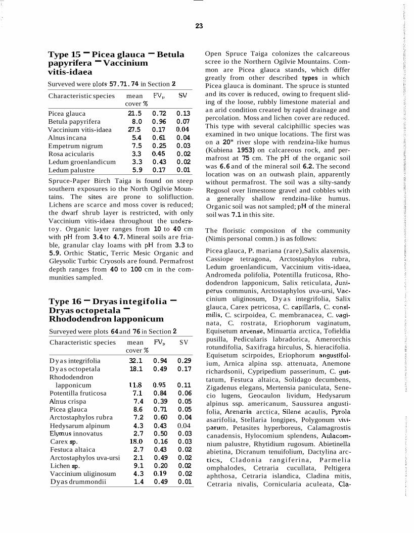
Type 16 - Dryas integifolia - Dryas octopetala - Rhododendron lapponicum Surveyed were plots 64 and 76 in Section 2 Characteristic species mean FV, SV
Dyas integrifolia 32.1 0.94 0.29 Dyas octopetala 18.1 0.49 0.17 Rhododendron
lapponicum 11;s 0.95 0.11 Potentilla fruticosa 7.1 0.84 0.06 Ahus crispa 7.4 0.39 0.05 Picea glauca 8.6 0.71 0.05 Arctostaphylos rubra 7.2 0.60 0.04 Hedysarum alpinum 4.3 0.43 0.04 Elymus innovatus 2.7 0.50 0.03 Carex sp. 18.0 0.16 0.03 Festuca altaica 2.7 0.43 0.02 Arctostaphylos uva-ursi 2.1 0.49 0.02 Lichen sp. 9.1 0.20 0.02 Vaccinium uliginosum 4.3 0.19 0.02 Dyas drummondii 1.4 0.49 0.01
cover %
Open Spruce Taiga colonizes the calcareous scree io the Northern Ogilvie Mountains. Com- mon are Picea glauca stands, which differ greatly from other described types in which Picea glauca is dominant. The spruce is stunted and its cover is reduced, owing to frequent slid- ing of the loose, rubbly limestone material and a n arid condition created by rapid drainage and percolation. Moss and lichen cover are reduced. This type with several calciphillic species was examined in two unique locations. The first was on a 20" river slope with rendzina-like humus (Kubiena 1953) on calcareous rock, and per- mafrost at 75 cm. The pH of the organic soil was 6.6 and of the mineral soil 6.2. The second location was on a n outwash plain, apparently without permafrost. The soil was a silty-sandy Regosol over limestone gravel and cobbles with a generally shallow rendzina-like humus. Organic soil was not sampled; pH of the mineral soil was 7.1 in this site.
The floristic compositon of the community (Nimis personal comm.) is as follows:
Picea glauca, P. mariana (rare), Salix alaxensis, Cassiope tetragona, Arctostaphylos rubra, Ledum groenlandicum, Vaccinium vitis-idaea, Andromeda polifolia, Potentilla fruticosa, Rho- dodendron lapponicum, Salix reticulata, Juni- perus communis, Arctostaphylos uva-ursi, Vac- cinium uliginosum, D y a s integrifolia, Salix glauca, Carex petricosa, C. capillaris, C. consi- milis. C. scirpoidea, C. membranacea, C. vagi- nata, C. rostrata, Eriophorum vaginatum, Equisetum a&ense, Minuartia arctica, Tofieldia pusilla, Pedicularis labradorica, Amerorchis rotundifolia, Saxifraga hirculus, S. hieracifolia. Equisetum scirpoides, Eriophorum angustifol- ium, Arnica alpina ssp. attenuata, Anemone richardsonii, Cypripedium passerinum, C. gut- tatum, Festuca altaica, Solidago decumbens, Zigadenus elegans, Mertensia paniculata, Sene- cio lugens, Geocaulon lividum, Hedysarum alpinus ssp. americanum, Saussurea angusti- folia, Arenaria arctica, Silene acaulis, F'yrola asarifolia, Stellaria longipes, Polygonum vivi- parum, Petasites hyperboreus, Calamagrostis canadensis, Hylocomium splendens, Aulacom- nium palustre, Rhytidium rugosum. Abietinella abietina, Dicranum tenuifolium, Dactylina arc- tics, Cladonia rangi fe r ina , Parmel ia omphalodes, Cetraria cucullata, Peltigera aphthosa, Cetraria islandica, Cladina mitis, Cetraria nivalis, Cornicularia aculeata, Cla-

24
donia chlorophaea, Masonhalea richardsonii, Cladonia alpestris.
Type 17 - Equisetum arvense - Picea glauca - Salix pulchra Surveyed were plots 26, 29, 31. 33, 35 in Sec- tinn 4
Characteristic species mean FV, SV cover %
Equisetum arvense 28.9 0.73 0.18 Picea glauca 18.9 0.73 0.11 Salix pulchra 21.8 0.33 0.06 Populus balsamifera 5.2 0.53 0.04 Arctagrostis latifolia 5.3 0.66 0.03 Vaccinium uliginosum 9.1 0.23 0.03 Hedysarum alpinum 3.0 0.52 0.03 Arctostaphylos rubra 4.0 0.36 0.02 Salix reticulata 2.9 0.45 0.02 Rosa acicularis 3.2 0.40 0.02 Petasites frigidus 1.9 0.43 0.01 Ranunculus lapponicus 1.1 0.59 0.01
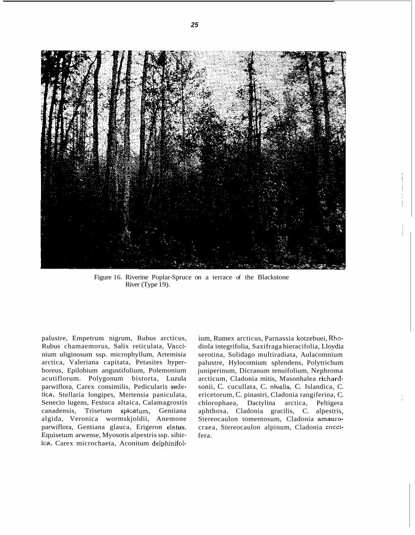
Riverine stands of Picea glauca and Populus balsamifera occupy alluvial valleys in the West- ern Foothills of the Richardson Mountains. The species composition depends on the stage of the successional sere. Various associations of bal- sam poplar, white birch and white spruce were found in this region by Hettinger. Janz and Wein (1973). The soils of the flood plain are fre- quently deep sandy Regosols (soils with little horizon development). Permafrost is absent.
On the terraces and river valley slopes with 25- 30 cm of fibrous peat over 10 to 20 cm of well- decomposed peat that is frozen at 45 cm, Picea glauca becomes codominant with alder, to the exclusion of poplar. Vegetation is similar to that of Types 10 and 11 as well as 13. These sites may exhibit hummocky terrain and water-log- ging. The soils are of the Cryosolic order. Drew and Shanks (1965) describe similar spruce-for- est terrace vegetation ~ e s in the Upper Firth River.
~
Type 18 - Salix pulchra - Equisetum arvense - Calamagrostis canadensis Surveyed were 7 plots: namely, 85, 88, 89, 91 and 96 in Section 1 and plots 56 and 73 in Sec- tion 2
Characteristic species mean FV, SV cover %
Salix pulchra Equisetum arvense Calamagrostis
canadensis Potentilla fruticosa Agropyron violaceum Carex sp. Delphinium glaucum Festuca brachyphylla ~-
64.8 0.33 0.19 17.8 0.52 0.11
6.6 0.48 0.04 3.0 0.61 0.03 1.8 0.55 0.02
11.1 0.08 0.01 1.4 0.54 0.01 1.2 0.57 0.01
This is a Riverine Willow of dense, vigorous Salix pulchra in the South Ogilvies. It is less prevalent in the North Ogilvies. This type is common on riverine sites or meadows of gener- ally hygric to mesic moisture conditions. Per- mafrost is absent. Equisetum arvense may be abundant; lichen cover is reduced. The presence of Delphinium glaucum, common to thickets along stream banks (Welsh 1974). characterizes this type. Silt and sand mixed with organic debris form the substrate. Soils are Gleyed Regosols, often underlain with gravel and boul- ders. Little or no organic horizon is present. The pH of the organic soil ranges from 5.4 to 6.9 and of the mineral soil from 4.8 to 7.2
In the North Fork Pass region, Richer (1968) describes a “Moist Shrub Meadow Community Complex” which occupies gentle slopes, troughs, flat floored depressions and shallow gullies. Richer compares his type to Porsild’s (1951) “Subalpine Meadow Habitat” as defined within the Mackenzie Mountains, and to Spetz- man’s (1959) “Tall Shrub Stage” of the “Flood Plain Community” of the North slope of Alaska. This type has also been recognized by Nimis (personal comm.) and is called “Artemisio-Sali- cetum Pulchrae”. Nimis’s type is composed of dense Salix thickets and a mixture of grasses, which can be more-or-less open, with domi- nance of lichens in the understory, or more-or- less closed and very poor in species. The specific floristic compositon of the type described by Nimis is as follows:
Salix pulchra, Betula glandulifera, Ledum
25
Figure 16. Riverine Poplar-Spruce on a terrace of the Blackstone River (Type 19).
palustre, Empetrum nigrum, Rubus arcticus, Rubus chamaemorus, Salix reticulata, Vacci- nium uliginosum ssp. microphyllum, Artemisia arctica, Valeriana capitata, Petasites hyper- boreus, Epilobium angustifolium, Polemonium acutiflorum. Polygonum bistorta, Luzula parwiflora, Carex consimilis, Pedicularis sude- tica, Stellaria longipes, Mertensia paniculata, Senecio lugens, Festuca altaica, Calamagrostis canadensis, Trisetum spicatum, Gentiana algida, Veronica wormskjoldii, Anemone parwiflora, Gentiana glauca, Erigeron elatus, Equisetum arwense, Myosotis alpestris ssp. sibir- ica, Carex microchaeta, Aconitum delphinifol-
ium, Rumex arcticus, Parnassia kotzebuei, Rho- diola integrifolia, Saxifraga hieracifolia, Lloydia serotina, Solidago multiradiata, Aulacomnium palustre, Hylocomium splendens, Polytrichum juniperinum, Dicranum tenuifolium, Nephroma arcticum, Cladonia mitis, Masonhalea richard- sonii, C. cucullata, C. niwalis, C. Islandica, C. ericetorum, C. pinastri, Cladonia rangiferina, C. chlorophaea, Dactylina arctica, Peltigera aphthosa, Cladonia gracilis, C. alpestris, Stereocaulon tomentosum, Cladonia amauro- craea, Stereocaulon alpinum, Cladonia cocci- fera.

26
Type 19 - Alnus incana - Populus balsamifera - Equisetum arvense Surveyed were plots 55 and 58 in Section 2 and plot 41 in Section 3. Characteristic species mean FV, SV
cover % Alnus incana 41.3 0.93 0.35 Populus balsamifera 34.3 0.89 0.28 Equisetum arvense 27.8 0.71 0.17 Pyrola asarifolia 7.4 0.91 0.07 Shepherdia canadensis 4.8 0.61 0.04 Rosa acicularis 4.6 0.68 0.03 Picea glauca 5.2 0.72 0.03 Calamagrostis
canadensis 3.8 0.43 0.02 Viburnum edule 1.8 0.65 0.02 Salix pulchra 6.2 0.32 0.02 Agropyron sp. 1.8 0.63 0.02 Riverine Poplar-Spruce was observed in alluvial valleys of the Ogilvie Mountains and the Eagle Plains. This type, recognized by Nimis as “Popu- letum Balsamiferae”, occurs as a relict in the surveyed region. It is common on permafrost- free flood plains and terraces. Floristically, this type is characterized by the presence of per- mafrost-intolerant species. Mosses and lichens are scarce. The ground is either bare or covered with hardwood litter. Soils are Gleyed Regosols, with sandy mineral soil underlain by gravel; there is little or no humus layer. Where an organic horizon is present, the pH is 6.5; pH of the mineral soil ranges from 6.2 to 7.1.
The floristic composition of the community described by Nimis is as follows:
Populus balsamifera, Populus tremuloides, Picea glauca, Salix pulchra, Salix alaxensis, Ribes hudsonianum, Ribes triste, Shepherdia canadensis, Viburnum edule, Alnus incana. Arc- tostaphylos rubra, Salix arbusculoides, Epilo- bium angustifolium, Mertensia paniculata, Artemisia borealis, Equisetum arvense, Delphi- nium glaucum. Aconitum delphinifolium, Anemone richardsonii, Ranunculus macounii, Pyrola grandiflora, Cypripedium passerinum, C. guttatum, Lupinus arcticus, Galium boreale, Solidago decumbens, Deschampsia caespitosa, Hedysarum alpinum ssp. americanum.
Type 20 - Populus balsamifera - Lupinus arcticus - Betula glandulosa Surveyed was plot 13 in Section 6 Characteristic species mean FV, SV
cove-T 4:
Populus balsamifera 13.6 0.87 0.10 Lupinus arcticus 5.5 0.83 0.04 Betula glandulosa 11.7 0.32 0.03 Salix pulchra 11.7 0.31 0.03 Lichen sp. 14.9 0.20 0.03 Empetrum nigrum 5.5 0.38 0.02 Rosa acicularis 2.7 0.02 0.02 Epilobium angustifolium 1.4 0.99 0.01 Poa alpigena 1.4 0.95 0.01 Vaccinium vitis-idaea 8.6 0.16 0.01 Petasites sagittatus 1.4 0.90 0.01 These are stunted, tall-shrub-like stands on southwestern exposure alluvial valley slopes in the Eastern Foothills of the Richardson Moun- tains (possibly a phase of Type 19) of scattered poplar, birch, white spruce and willow. Tree growth is poor in comparison with the stands located in the Ogilvies and Eagle Plains (Type 19). Ground cover is reduced to litter and lichens. The soil is Gleyed Dystric Brunisol. The upper 20 cm is gravelly with fine textured soil material. With depth, the soil contains larger stones and, finally, boulders. Organic layer is not more than 4 cm and consists of fibrous material. The pH of the organic horizon is 4.8 and of the mineral horizon 4.3. Though not determined, permafrost could be suspected at a depth of 1.5 metres.

27
Figure 17. Tall-shrub-like stands (Type 20) on south-west exposure alluvial valley slope in the eastern foothills of the Richard- son Mountains.

28
B. Discussion of
Because of relevance to the conducted survey. a description of areas south of North Fork Pass along the Dempster Highway is included.
1. Areas from Klondike Highway to North Fork Pass: The lower North Klondike valley lies within the zone of the main boreal forest (Richer 1968). The types present in this section are similar to those occurring in Southern and Central Yukon and to several types north of North Fork Pass, where their occurrence is limited in area. Black Spruce stands (Type 9) are the dominant vege- tation M e on the lowlands. The rivers are lined with the typical White Spruce stands (Type 14) which, when their canopy closes, become “Hylocomio-Piceetum glaucae” community (description under Type 14).
Stands of Populus tremuloides occurs on steep slopes. very similar floristically to the “Popule- tum tremuloides” which occupies vast areas along the Klondike and Alaska highways after fire or occurs as an edaphic climax community on arid slopes.
Riverine Poplar (Type 19) occurring along streams near the water on gravel, can be con- sidered a relict of a vegetation which is better developed further south. Carex communities are found along margins of ponds, mostly in standing water. A pioneer community of Salix occurs along the river on gravel, usually within reach of flood water. Further north in this sec- tion, the boreal forest gives way to a “sub- alpine’’ vegetation which in turn assumes a n “alpine” character in the Ogilvie Mountains.
2. Section 1 - South Ogilvie Mountains The Southern Ogilvie Ranges rise as a distinct fault-line scarp to the northeast of the Tintina Valley. The ranges are underlain by a complex, folded and faulted Precambrian to Cretaceous succession of layered volcanics, clastic sedi- ments and prominent dolerite sills (diabase dike or sheet, Richer 1968). The average and maxi-
Discrete Sections.
mum relief of the ranges are approximately 900 and 1800 metres, respectively (Cockfield 1920). Estimated precipitation is about 380 mm in the west and 635 mm in the northeast. The mean annual precipitation is 453 mm (Oswald and Senyk 1977). Mean annual temperature mea- sured at a station at 991 m is -7C.
Beginning at the Tombstone campsite, the road rises in a short distance from 1034 to 1289 m through Precambrian volcanic rocks, quartzite and schists. This results in a sharp change in vegetation; the subalpine character gives way to an “alpine tundra” at the crest of North Fork Pass. Black Spruce Taiga (Type 9) is replaced by Salix thickets (Type 18). which dominates the river banks and seepage sites until the road descends to the level of the Blackstone River. Richer (1968) estimates that this willow com- munity covers one quarter to one third of the section. Solifluction is extremely common on the high gradient slopes, giving way to a micro- pattern in the vegetation distribution not studied during our survey. Wind-blown rock outcrops and colluvium are colonized by Type 6, a Lichen Heath “Alpine” Tundra. The frequent seepage sites support a characteristic vegetation with Claytonia tuberosa. This type restricted to the edges of small drainage channels. Nimis (per- sonal comm.) provides the following floristic composition:
Claytonia tuberosa, Saxifraga reflexa, Juncus castaneus, Parnassia kotzebuei. Polemonium acutiflorum. Cardamine pratensis ssp. angusti- folia, Polygonum bistorta, Valeriana capitata, Petasites hyperboreus, Luzula parviflora, Rumex arcticus, Veronica wormskjoldii.
On both sides of the Blackstone River, the land- scape is dominated by a Low Shrub Tussock Tundra (Type 1) occurring intermittently on low gradient slopes and polygon fields. Going futher north from the pass, there is a n interdigitation of several tundra types giving way to what Richer (1968) refers to as Sylvotundra or Forest Tundra, with the typical White Spruce Wood (Type 14) growing on stable southern exposure slopes. At the margin of the ponds, a Carex

29
association, not sampled here, occurs.
On the whole, the passage from Klondike River to the Blackstone River reveals drastic changes, topographically and floristically with the appearance of many potentially rare arctic
alpine” species. Permafrost is common throughout the area, affecting nearly all the vegetation types [except, as it appears, the asso- ciation with Hierochloe alpina (Type 6) and the one with Claytonia tuberosa]. According to Brown 1978, the area lies within the discontinu- ous widespread permafrost subzone.
“
3. Section 2 - North Ogilvie Mountains. The vegetation of the calcareous Ogilvie Moun- tains is most interesting because of the presence of many potentially rare species, probably gla- cial relicts, the varying geomorphology and the complexity of successional seres. This area should be studied in more detail.
Apparently, the geomorphology of the area affects the vegetation distribution and succes- sion. Where the road turns west of the Black- stone River, the landscape changes drastically. Hills consisting of calcareous material appear and continue to about 3 miles north of the Ogil- vie River. As the result of cryoclastic action, rocky debris covers much of the slopes from the top to the base. Here and there, but mainly on top, serrated ramparts and tors persist, provid- ing a n almost eerie scenery. Most elevations are between 900 and 1350 metres (Oswald and Senyk 1977).
The surface of the scree is unstable and by this, the development of the vegetation cover is strongly affected. Climatic conditions appear to be similar to those encountered in Section 1. The flora colonizing the hills includes a number of potentially rare basiphytic species: many of them can be considered as glacial relicts. Among others are Antennaria friesiana, Cam- panula aurita, Lesquerella arctica, Phlox sibir- ica, Parrya nudicaulis, Thalictrum alpinum, Eri- trichium aretioides, Tofieldia coccinea, Senecio hyperborealis, Aster alpinus ssp. vierhapperi (Nimis personal comm.). Thus, the vegetation differs strongly from that on comparable sites in the other sections.
The bare rock is colonized by scattered individu- als of Asplenium viride, Cystopteris fragilis and
Saxifraga tricuspidata. Among the lichens, the most common are Cetraria tilesii and Cladonia pyxidata (on Regosols). This pioneer stage is fol- lowed by an interesting association, colonizing most of the more stable slopes, containing the greatest concentration of potentially rare spe- cies. Nimis (personal comm.) provides the fol- lowing floristic composition:
Carex petricosa, C. glacialis, Dryas integrifolia, Saxifraga oppositifolia, Eritrichium aretioides, Cardamine purpurea, Festuca altaica, Asplen- ium viride, Androsace lehmanniana, Cystopteris fragilis, Antennaria friesiana, Campanula aurita, Lesquerella arctica, Phlox sibirica, Sene- cio hyperborealis, Parrya nudicaulis, Arctosta- phylos uva-ursi, Aster alpinus ssp. vierhapperi, Anemone multifida, Thalictrum alpinum, Ziga- denus elegans, Saxifraga tricuspidata. Carex rupestris, Anemone richardsonii, Tofieldia pusilla, Castilleja elegans, Cetraria nivalis, C. tilesii, Cladonia alpestris, C. chlorophaea. Cor- nicularia aculeata, Thamnolia subuliformis, Cetraria islandica, C. cucullata.
On steep, open, north exposure slopes, which exhibit typical step formations created by solifluction, is the Lichen Heath Alpine Tundra community identified by Nimis as “Lichen- Heirochloe alpina” and described as Type 6 in our survey.
On arid slopes, the vegetation tends to evolve toward Type 16, an open Spruce Dryas Taiga, characterized by the presence of calciphilic spe- cies unique to this section. Frequently, this type is destroyed by slope creep and replaced by the pioneer association mentioned previously.
Near the road, in protected areas and in well- drained river valleys, there are remnants of Type 14, a White Spruce Wood, and the “Hylo- comioPiceetum glaucae”. In the lower eleva- tions where mesic to moist conditions prevail, Black Spruce Taiga (Type 9), occupies areas with organic soils and shallow active layers. This latter association, particularly the sub- association dominated by Sphagna, is not as common in this section as in the area from Klondike Highway to North Fork Pass, probably because water percolating through the calcare- ous debris is enriched in bases and the Sphagna are acidophytic plants.
Well-drained warmer sites with permafrost-free soils along rivers and in recent floodplains sup- port Type 19, a Riverine Poplar community, tall

30
Salix thickets (Type 18) are widespread mainly along the river floodplains. On extreme gradient slopes with southern exposure, Picea mariana is associated with Betula papyrifera and forms Spruce Birch Taiga communities (Type 15).
It may be stated that this section requires most care in case of any anthropogenic action, both for the peculiar flora and vegetation, and for the complex dynamics of the geomorphological processes.
4. Section 3 - Eagle Plains The bedrock underlying the Eagle Plain include sedimentary rock consisting of shale, conglom- erate, sandstone and surficial deposits of lime- stone and dolomite (Douglas and Maclean 1963). Although the region was not glaciated during Laurentide or Wisconsin periods, ice fronts lying adjacent to the Eagle Plains dis- charged melt waters, a process which resulted in deposits of glaciofluvial and lacustrine mate- rials in upstream valleys of the Eagle River.
Precipitation in this region ranges from 250 to 500 mm. Mean annual temperatures are between -7C and -lOC (Burns 1973, 1974). Per- mafrost is extensive, the active layer ranging in depth from 40 to 150 cm in the areas sampled, but is absent from the drainage channels and river beds.
Picea mariana provides the most common tree cover of the Eagle Plain. On gentle western or southwestern slopes below treeline, an open- canopied Lichen Spruce Taiga (Type 12) occurs, which is unique to this section. Complex open Black Spruce Tall Shrub Taigas (Type 11) are found on steep southern exposures. Where hum- mocks are present, a variety of microsites are present in the hummmocks and inter-hummock troughs: this terrain supports an open taiga with clumps of stunted spruce surrounded by low eri- caceous shrubs (Type 10).
Where drainage is impeded, hummocks and polygons are colonized by Heath Sedge (Type 2) and Tussock Sedge (Type 1) Tundra. On flats along the Eagle River is found Riverine Poplar characterized by the presence of permafrost- intolerent species (Type 19). Over much of the Eagle Plain, but not consistently, Larix laricina is associated with Picea marianna in the tree layer. The understory, though not sampled, appears to be similar to that of other black spruce taiga types.
5. Section 4 - Western Foothills of the Richardson Mountains From about the Arctic Circle, the highway par- allels the Western Foothills of the Richardson Mountains, which are comprised of a series of prominent pediments shaped as whalebacks. The bedrock consists of shale. The slopes drain into the Porcupine River, the Bell River being a major channel (Oswald and Senyk 1977). This area was apparently not glaciated during the Wisconsin or Laurentide periods as the moun- tains formed an effective barrier to the westerly moving Laurentide ice sheet.
Burns (1973, 1974) gives the mean annual pre- cipitation of 500 mm and mean annual tem- peratures at about -9C for the Richardson Mountains. This section appear to lie just south of the continuous permafrost.
Peat plateaus are common in the foothills and have polygonal surfaces. Hummocky terrain is also common, although not as prominent as in areas further east. Unsorted circles, solifluction patterns and active cryoturbation are wide- spread.
Carex and Eriophorum tussocks are prevalent among the tundra types (Type 1); where soils are stony, alder and willow thickets are associ- ated with the tussocks to form a Tall Shrub Tun- dra (Type 4).
Prominent, but infrequent, are spruce and poplar stands on well-drained river banks and stabilized flood plains; Picea glauca becomes dominant and associated with alder on peat pla- teaus (Type 17). Picea mariana and Larix lari- cina with a closed shrub understory and a thick cover of Sphagnum moss (Type 13) occur in hummocky terrain.
6. Section 5 - Richardson Moun- tains Section 5, the shortest of the surveyed sections, covers the traverse of Richardson Mountains by the Dempster Highway. The bedrock materials are complex, with Jurassic shales, sandstone and conglomerates overlain by Permian sand- stones and conglomerates, with some isolated Cambrian and Precambrian outcrops (Hett- inger, Janz and Wein 1973). With the exception of their southern tip, the Richardson Mountains lie within the zone of continuous permafrost (Oswald and Senyk 1977). Vegetation distribu-

31
tion is presumably governed by the continuous permafrost; the active layer is shallow in most of the section.
In the surveyed part of this section, tundra pre- dominates; the Richardson Mountains lie within the tundra region of Rowe (1972). Sedge Tus- sock Tundra (Type 1) is extensive on a variety of terrain types. Where the terrain is hummocky, a closed ground cover of Sphagnum, Polytrichum and Hylocomium persists under widely spaced low shrubs and dwarf willow (Type 3). On steep northern exposure slopes, Type 7, characterized by Cassiope tetragona, is found. On moderate slopes where soil is extremely stony and organic layers are shallow, the tundra is dominated by Betula glandulosa and lichens (Type 8). On tun- dra peat, stunted Picea mariana among tall shrubs (Type 11) occurs. The tundra at a higher elevation, though meriting attention, was not surveyed.
7. Section 6 - Eastern Foothills of the Richardson Mountains This section covers the Eastern Foothills of the Richardson Mountains and is part of the Peel Plateau. Bedrock materials are Lower Creta- ceous shales, sandstones and conglomerates (Hettinger. Janz and Wein 1973). Much of the area was glaciated by the Laurentide ice sheet, and has been mapped by Hughes (1972) as ridged moraine with glacial till covered by silt and organic deposits. except those areas in river valleys. Deep, medium textured morainal mate- rial is extensive along these eastern slopes (Hughes 1972). The slopes drain eastward by several tributaries to the Peel River and Mac- kenzie Delta. Temperature extremes, recorded a t Fort McPherson, are a high of 34°C and a low of -56'C. Mean annual air temperatures indicate that the study area is almost entirely within a continuous permafrost zone (Brown 1970). Frost-free days have averaged 75 for Fort McPherson, with a n annual variation of 103 to 8 (Canada Department of Transport 1967). The distribution of vegetation in the Eastern Foothills is greatly influenced by a continuous hummocky micro-relief found on most of the medium and fine textured materials. Depth of organic layers, soil moisture content, depth of active layer, soil texture and rate of seasonal thawing are different on different parts of the hummocks, producing varied plant environ-
ments within very short distances, and deter- mining the distribution and growth of vegeta- tion. Hummocks, composed of soil with high organic content, rise 40-70 cm above thick moss layers (usually Sphagna) found in the inter-hummock troughs. Generally, soils associ- ated with this terrain are extremely cryotur- bated and high in ice content.
An open taiga with stunted Picea mariana (Type 10) and Shrub Tundra (Type 5 ) are found on this hummocky terrain. Picea mariana occupies more than 50% of this area (Forest Manage- ment Institute, CFS, 1974). In areas devoid of hummocks, on wet, poorly drained sites, open treed-bog-like stands of Picea mariana and Larix laricina develop (Type 13), often with a dense shrub layer in the understory. Oswald and Senyk (1977) recorded that larch is common, with black spruce, on poorly drained areas in the Peel Plateau.
Special conditions exist on alluvial soils in the major river valleys; these sites are generally the warmest in the region and protected valleys are periodically enriched with alluvial deposits (Zol- tai and Pettapiece 1973). This fact, and the depth of the active layer (up to 150 cm) caused by the warmer conditions, contribute to the development of a "River Bank Taiga" (Type 20) with a vegetation-soil-permafrost system pecu- liar to these sites.
References
Barkman, J.J.. J. Moravec and S. Rauschert. 1976. Code of phytosociological nomenclature. Vegetatio 31: 131-185.
Brom, R.J.E. 1970. Permafrost in Canada. Universiw Toronto Press. 234 p.
B r o w , R.J.E. 1978. Permafrost in Canada. In Hydrological Atlas of Canada. Dept. of Fisheries and Environment Canada. 34 maps.
Burns. B.M. 1973. The climate of the Mackeniie Valley - Beaufort Sea. Vol. 1. Environ. Canada, Atmosph. Envi- xon. Climatological Studies No. 24.
Burns. B.M. 1974. The climate of the Mackenzie Valley - Beaufort Sea. Vol. 11. Environ. Canada, Atmosph. Environ. Climatological Studies No. 24.
Canada Department of Transport. 1967. Temperature and precipitation tables for the North - Y.T. and N.W.T. 21 P.
Canada Soil Survey Committee. 1978. The Canadian sys- tem of soil classification. Can. Dept. Agric., Res. Branch. Publ. 1646. Supply and Services, Canada, Ottawa, Ont. 164 p.

32
Cockfield. W.E. 1920. Explorations in the Ogilvie Range. Yukon. Summ. Rept. Geol. Surv. Can. (1919) pt. A: p. I1 and pt. B p. 107.
Crum.H.A., W.C. Steere and L.E. Anderson. 1973. A new list of mosses of North America north of Mexico. The Bryolagist 76: 85-130.
Douglas. R.J.W. and B. Maclean. 1963. Geology of Yukon Territories and Northwest Territories. Geol. Surv. Can.. Map 30 - 1963.
Drew, J.V. and R.E. Shanks. 1965. Landscape relationships of soils and vegetation in the forest-tundra ecotone. upper Firth River Valley. Alaska - Canada. Ecol. Monagr. 35: 285-306.
Dymess. C.T. and L.A. Viereck. 1979. A suggested classification for Alaska vegetation. U.S. Forest Sew. unpubl. rept. 52 p.
Foothills, 1979. Project Dempster Lateral Gas Pipeline. Environmental Impact Statement. Vol. 4. Foothills Gas Pipe Lines (Yukon) Ltd., 1600 Bow Valley Square 11, 205 - fifth Ave. S.W.. Box 9083. Calgary. Alberta, T2P 2W4. June. 1979.
Forest Management Institute. 1974. Vegetation types of the Mackenzie Corridor. Environ-Social Comm.. North. Pipelines. Task Force on North. Oil Dew, Go". Can.. Rep. No. 73-46.85 p.. appendices and maps.
Hale, M.E. and C.E. Culberson. 1970. A fourth checklist of the lichens of the continental United States and Can- ada. The Bryologist 73: 499-543.
Hettinger. L.. A. Janz and R.W. Wein. 1973. Vegetation of the northern Yukon Territory. Arctic Gas. Biolag. Rept. Series Vol. 1. Northern Engineering Sewices Co. Ltd.
Hughes. O.L. 1972. Suficial geology of Northern Yukon Territory and Northwestern District of Mackenzie, N.W.T. Geol. Survey Can. Paper 69-36.
Hulten. E. 1966. New species of Armaria and Draba from Alaska and Yukon. Bot. Notiser 119(2): 313-316.
Hulten, E. 1968. Flora of Alaska and neighboring Territo- ries. Stanford Uniu. Press. 1008 p.
Klohn Leonoff Consultants Ltd. 1977. Terrain evaluation for Foothills (Yukon) pipeline route. Document 13. P. 7e No. A10731, prepared for Foothills. 7 p. tables and appendices.
Klohn Leonoff Consultants Ltd. 1978. Dempster Lateral drilling program. Vols. 1 and 2.
Krajina. V.J. 1963. Biogeoclimatic zone and plant associa- tion in some parts of the Richardson Mountains and the Mackenzie River delta. Dept. Biol. and Botany. Univ. Brit. Col. Mimeo. 4 p.
Krajina. V.J. 1965. Biogeoclimatic zones and biogeocoe- noses of British Columbia. In Ecology of Western North America. Dept. Botany. Univ. British Columbia. Van- couver. B.C..Canada.Vol. 1: 1-17,
Krajina. V.J. 1975. Some observations on the subalpine biogeoclimatic zones in British Columbia. Yukon and Mackenzie District. Pliytocoenalogia 2(%): 396-400.
Kubiena. W.L. 1953. Soils of Europe. Thomas Murby. Lon- don. 318 p.
Macleod. W.G. 1979. The Dempster Highway. Canadian Arctic Resources Committee. 46 Elgin Street - Room II. Ottawa, Ontario. KIP 5K6.57 p.
Orloci. L. and W. Stanek. 1980. Vegetation survey of the Alaska Highway. Yukon Territory; t y p s and gradients. Vegetatio 41. 57 p.
Oswald, E.T. and J.P. Senyk. 1977. Ecoregians of Yukon Territory. Fisheries and Environment Canada. Cana- dian Forestry Service. BC-X-164 June. 1977.
Parsild. A.E. 1951. Botany of the southeastern Yukon adja- cent to the Canol Road. Nat. Mus. Can. Bull. 121: 1- 400..
Porsild. A.E. 1967. Drabo sibirica (Pall.) Thell. in North America. Can. Field-Naturalist 8U.3): 165-167.
Richer, K.E. 1968. Quaternary geology in the Southern Ogil- vie Ranges, Yukon Territory and an investigation of morphological. periglacial. pedological and botanical criteria for possible use in the chronology of morainal sequences. MSc. Thesis. Department of Geology, h i - versity of British Columbia. 211 p. Appendix 124A. maps.
RobertsPichette. P. 1972. Annotated bibliography of per- mafrost-ueg- etation-wildlife-landform relations. Dept. Environ. For. Manag. Inst. Inf. Rept. FMR-X-43.
Rowe, J.S. 1972. Forest Regions of Canada. Dept. Environ. Can. For. Serv. Publ. No. 1300.
Schulh International Ltd. 1972. Environmental impact study of the Dempster Highway. For Department of Public Works of Canada. Vancouver, B.C. Folio 1 of 2 Folios, September 1972.68 p. and appendices.
Spetman. L.A. 1959. Vegetation of the Arctic Slope of Alaska. Geol. Sum. Prof. Paper 302-8 58 p.
Stanek. W. and Orloci. L. 1973. A comparison of Braun- Blanquet's method with sum-&squares agglomeration for veg.etation classification with an appendix and algorithm for cluster seeking in ecological collections. Vegetatio 27(4-6): 323-345.
Stanek. W. 1980. Vegetation types and environmental fac- tom associated with Foothills gas pipeline route, Yukon Territory. Canad. For. Serv.. Pacific For. Res. Centre. BC-X-205.48 p.
Vaartnou & Sons Enterprises Ltd. 1979. Shrubs. grasses and legumes proximal to the route of the proposed Dempstcr lateral gas pipline. Prepared for Foothills Pipe Lines7Yukon) Ltd. 110 p.
Viereck. L.W. 1966. Plant succession and soil development on gravel outwash of the Muldrow Glacier. Alaska. E d . Mon. 36: 181-199.
Welsh, S.L. 1974. Anderson's flora of Alaska and adjacent parts of Canada. Brigham Young Univ. Press. Provo. Utah. 724 p.
Zoltai. S.C. and W.W. Pettapiece. 1973. Studies of vegeta- tion. landform and permafrost in the Mackenzie Valley: Terrain. vegetation and permafrost relationships in the northern part of the Mackenzie Valley and northern Yukon. Environmental-Social Committee. Northern Pipelines. Task Force on Northern Oil Dcvel. Rept. No. 734 .
Zaltai. S.C. and W.W. Pettapiece. 1974. Tree distribution on perennially frozen earth hummocks. Arctic and Alpine Research 6: 403-41 1.
Zoltai. S.C. and C. Tarnacai. 1974. Soils and vegetation of hummocky terrain. Environmental - Social Commit- tee. Northern Pipelines. Task Force on Northern Oil Devel. Rept. No. 74-5.