Aleutian Islands and Atka-Amlia Ilands Areas Salmon Management

Reconnaissance Geol(l§f of Southern Atka Island, Aleutian Islands, Alaska
~
• r d ~=-I • Jo ; I ' ,10
I .... ~ '' I
.. I: I
• ~1 11" I •
r ' '
i ~ •. ' ~J • ~ •• t' .. _"Oc
I ~·. &
- • .. " ..
I'~
1:
1. ~
' I
·t • r · ......
I
' .f I
,. t
·: ,r .,
I~~~~·~~~
'• ,, •, I.
• I i
,-
r ' ~' .
'., .. ;'


Reconnaissance Geology of Southern Atka Island, Aleutian Islands, Alaska
By James R. Hein, Hugh Mclean, and Tracy Vallier
U.S. GEOLOGICAL SURVEY BULLETIN 1609

DEPARTMENT OF THE INTERIOR
WilliAM P. ClARK, Secretary
U.S. GEOlOGICAl SURVEY
Dallas l. Peck, Director
UNITED STATES GOVERNMENT PRINTING OFFICE 1984
For sale by the Distribution Branch, Text Products Section U.S. Geological Survey 604 South Pickett St. Alexandria, VA 22304
Library of Congress Cataloging in Publication Data
Hein, James R. Reconnaissance geology of southern Atka Island, Aleutian Islands, Alaska.
(U.S. Geological Survey bulletin 1609) Bibliography: p. 18-19 Supt. of Docs. no.: I 19.3:1609 1. Geology-Alaska-Atka Island. I. Mclean, Hugh, 1939-
. II. Vallier, Tracy lowell, 1936- . Ill. Title. IV. Series: United States. Geological Survey. Bulletin 1609. QE75.B9 no. 1609 557.3s 84-600043 [QE84.A84] [557.98'4]

CONTENTS
Abstract 1 Introduction 1 Stratigraphy and paleontology 2
Paleogene sedimentary rocks 2 Middle and upper Miocene (synplutonic) sedimentary rocks 5
Petrography of sedimentary rocks 6 Igneous rocks 7
Plutonic rocks 8 Volcanic rocks 11 Geochemistry 11
Regional patterns of alteration 14 Structure 15
Folds 15 Faults 15
Resource potential 15 Summary and conclusions 16 References cited 18
FIGURES
1. Geologic map of Atka Island 3 2. Structural map of Atka Island 4 3. Schematic and interpretative cross section of Atka Island 5 4. Photographs showing Paleogene sedimentary rocks of Atka
Island 6 5. Photographs showing synplutonic and postplutonic rocks of
Atka Island 7 6. Plot of Si02 content versus FeOT/MgO ratio for Tertiary rocks
of Atka Island 13 7. Ternary diagram of Sr-Ti-Zr contents of plutonic and volcanic
rocks 13 8. Rare-earth-element plot for selected rocks of Atka Island 13 9. Histograms showing alteration products of Atka Island rocks 14
TABLES
1. Locations of samples of Atka Island rocks 2 2. Carbon content of Atka Island sedimentary rocks 8 3. Fossils from Atka Island 9 4. K-Ar analysis of Atka Island igneous rocks 10 5. U-Pb analyses of zircon from tonalite of the Beaver Bay
pluton, Atka Island 11 6. Classification, ages, textures, and mineralogy of chemically
analyzed Tertiary igneous rocks of Atka Island 11 7. Chemical analyses of representative Tertiary igneous rocks of
Atka Island 12 8. Percentages of extensively altered rocks of Atka Island 15 9. Metallic-element contents in bulk and heavy-mineral separates
of sediment fractions from drainages in the Beaver Bay pluton, Atka Island 16
10. Chemical analysis of silica and hematite hydrothermal deposit in Nazun Bay, Uyak Island 17
III


Reconnaissance Geology of Southern Atka Island, Aleutian Islands, Alaska
By James R. Hein, Hugh Mclean, and Tracy Vallier
Abstract
Atka Island, one of the central Aleutian Islands is composed of two distinct parts: This report treat~ ~he southern part, consisting mostly of Tertiary Igneous and volcaniclastic rocks, and ignores the northern part, consisting of the late Cenozoic Korovin volcanic complex. The oldest sedimentary rocks (preplutonic), middle Eocene to middle Oligocene in age, compose a sequence of bedded marine sandstone m~dstone,. and minor conglomerate that interfinge; ~Ith massive volcanic flows, volcanic breccia, and rare pillow flows. Younger sedimentary rocks, of Miocene (synplutonic) age, occur only on the north shore and consist of sandstone, volcanic conglomerate, black carbonaceous mudstone, and volcanic debris flows bearing fossil logs.
Sandstone consists of volcanic plagioclase, volcanic-rock fragments, clinopyroxene, opaque grains, and rare fragments of microfossils and quartz. Secondary minerals are pore-filling cements of ~mectite, chlorite, and zeolites. Metamorphic grade mcreases from east to west (toward the plutons) in the sedimentary and volcanic rocks, from zeolite through prehnite-pumpellyite to greenschist-hornfels facies, characterized by chlorite, epidote, amphibole, and quartz. Overall, metamorphic grade on Atka is higher than on adjacent Amlia Island.
Volcanic rocks, mostly basalt, basaltic andesite, and andesite, were extruded during three eruptive episodes. The earliest episode was submarine and of middle(?) and late Eocene and early Oligocene age; the second episode extruded basalt and basaltic andesite in middle and late Miocene time; and, finally, stratovolcanoes of mostly Quaternary age arose on the northern part of the island. Plutonic rocks were intruded during the early, middle, and late Miocene.
The three plutons that were dated apparently young toward the west. Plutonic rocks are gabbro, diorite, norite, tonalite, and quartz diorite; quartz diorite is the dominant plutonic-rock type. Most of these rocks have hypidiomorphic-granular textures, and euhedral to subhedral crystals of plagioclase, mafic minerals, and Fe-Ti oxides occur with anhedral quartz.
Plutonic and volcanic rocks show both calcalkaline and tholeiitic trends. Differences in the state of differentiation can explain the two series.
Folds are generally gentle and open; however, dips of rocks locally exceed 70° where drag folds result from faulting. Faults of small displacement are common. Faulting produced a pronounced east-westtrending topographic lineament that extends from the head of Egg Bay to Atka Village. Most faulting appears to be extensional, related to the emplacement of plutons and unrelated to compression associated with plate convergence along the Aleutian Trench.
Although no metallic ore deposits of economic importance were found on Atka Island, geochemical indicators suggest that further exploration is warranted for Cu, Pb, Ag, Sn, and possibly other metals. Reservoir and source-rock properties of rocks that crop out on Atka show little promise for petroleum primarily because of alteration resulting from plutonism. Offshore basins, however, offer a greater potential for petroleum development.
INTRODUCTION
Atka Island is situated in the central part of the Aleutian Islands and is part of the Andreanof Island gro~p (f.ig. 1). Atka sits atop the Aleutian Ridge, an ensimatiC volcanic archipelago that separates Pacific oceanic crust south of the ridge from older oceanic crust north of the ridge that forms the floor of the deep Bering Sea. The southern part of Atka Island is about 85 km long and averages about 10 km in width. Atka is separated from adjacent Amlia Island to the east by the 2-km-wide Amlia Pass. Adak Island, 175 km west of Atka, is the nearest large community and was our logistic support center. Atka Village, located at the head of Nazan Bay, is inhabited by a small population of Aleuts. Besides the naval station on Adak Island, Atka Village is the only community in the Andreanof group of islands.
Atka Island is geographically and geologically composed of two parts, which are joined by a 3-kmwide isthmus separating Korovin and Nazan Bays (figs. 1, 2). The northern part of the island consists of an uppermost Tertiary and Quaternary volcanic terrane the informally named Korovin volcanic complex, that includes historically active Korovin Volcano and an older stratovolcano, Mount Kliuchef. The elongate southern part of the island consists of Tertiary rocks underlying an east-west-trending mountainous ridge. Numerous elongate bays, rocky headlands, and small islands mark the shoreline of the southern part of the island.
Atka and Amlia Islands were among a small number of Aleutian Islands that had not previously been mapped geologically, even on a reconnaissance scale. Former work on southern Atka consisted of a brief description of fossil mollusks from shore exposures near Martin Harbor by Grewingk (1850), who visited the area during the period of Russian occupation. The Quaternary volcanic terrane of northern Atka Island was mapped by B. D. Marsh (Johns Hopkins University) in 1977 but not published.
We did reconnaissance mapping, mostly shoreline geology, and sample collecting of Tertiary rocks on Atka Island in 1977 and 1979 (table 1). This report presents data from our work and some broad interpretations based on them.
Introduction 1

Table 1. Locations of samples of Atka Island rocks
Field Latitude Longitude No. N. w.
877-6-3a2,a4 52°15 1 174°15 1
877-7-3A,B,F 52°10 1 174°(5 1
877-7-4C 52°1 o• 174°25 1
877-9-1 52°15 1 174°15 1
877-9-2A 52°15 1 174°15 1
877-10- LA ,b 52°05 1 174°05 1
877-10-2 52°05 1 174°10 1
877-H1-5A,R 52°05 1 174°15 1
877-11-1A 52°05 1 174°15 1
877-1?-1 52°05 1 174°25 1
877-12-4 52°0 5• 174°35 1
877-12-H 52°05 1 174°40 1
877-12-9,A 52°00 1 174°45 1
877-13-1A 52ono• 174°25 1
877-14-2d 52°00 1 174°45 1
877-14-3R 5 2°00 I 174°55 1
877-14-5 I I 52°00• 175°00 1
877-15-4 52°05• 175°10 1
877-15-5 52°00 1 175°05 1
877-16-5 52°05• 174°45 1
779-1fi-2 52°1 o• 174°10 1
779-18-1A,C 52°10 1 174°10 1
779-1g-1A 52°15 1 174°20 1
779-24-1A 5 2°05 1 174°10 1
779-24-2 52°05 1 174°40 1
779-24-3 52°05• 174°40 1
77g-24-4 52° o s• 174°40 1
779-?4-5 52°05 1 174°40 1
779-24-n 52°05 1 174°40 1
779-24-7 52°05 1 174°40 1
779-24-8 52°05 1 174°40 1
Acknowledgments.-Many people assisted us in the various phases of our field and laboratory studies. We thank Comdr. J. C. McCrork, Adak Naval Station; R. E. Portlock, U.S. Bureau of Indian Affairs, B. Mcintyre, U.S. Geological Survey; and the captain and crew of the U.S. Coast Guard cutter Midgett for logistic support. The Atka Village Council kindly permitted us to use their community as a base of operations. We thank the people of Atka Village for providing lodging and supplies, especially George Kudrin and Mike Snigaroff, and our small-boat crew Nicolas Dirks, Ronald Snigaroff, and Edward Nevzaroff. We also thank D. W. Scholl of the U.S. Geological Survey for encouragement and logistical support. Scholl and M. S. Marlow, U.S. Geological Survey, critically reviewed the paper. B. D. Marsh shared results of his fieldwork on northern Atka Island. M. A. Fisher was our able field assistant. Rosemary Sliney, Sara Monteith, Marla Wilson, Mary Ann Allen, Eva Vanek, and Lisa Morgenson, all of the
U.S. Geological Survey, provided technical assistance in the laboratory. Radiometric ages were provided by J. M. Mattinson, University of California at Santa Barbara, and M. L. Silberman and L. B. Gray, U.S. Geological Survey. Paleontologic ages were determined by D. Bukry, J. A. Barron, K. McDougall, J. A. Wolfe, R. A. Scott, and L. Marincovich of the U.S. Geological Survey, and F. H. Wingate of Cities Service Co. Chemical data were provided by H. T. Millard, D. McKown, R. Knight, J. Budahn, M. Taylor, M. Cremer, L. Espos, J. S. Wahlberg, J. Taggart, J. Baker, J. Kent, R. Lerner, and S. Neil, all of the U.S. Geological Survey.
STRATIGRAPHY AND PALEONTOLOGY
Southern Atka Island consists of a sequence of middle and upper Eocene and lower Oligocene (preplutonic) sedimentary rocks, interbedded with volcanic flows and breccias, that are intruded by early, middle, and late Miocene plutons. A sequence of middle and lower upper Miocene (synplutonic and postplutonic) volcanic flows, breccia, and sedimentary rocks unconformably overlies the older rocks; and in the vicinity of the isthmus separating the Korovin volcanic complex and the southern part of the island, the postplutonic rocks are, in turn, overlain by mostly Quaternary volcanic rocks of the Korovin volcanic complex (figs. 1-3).
Paleogene sedimentary rocks
The oldest rocks on Atka Island are a sequence of bedded marine sandstone, mudstone, and minor conglomerate that interfinger with massive volcanic flows, volcanic breccia, and rare pillow flows. Sedimentary rocks exposed along the west shore of Amlia Pass are mainly massive coarse-grained volcaniclastic sandstone with planar bedding and gentle dips (figs. 1, 2). Framework grains consist of moderately sorted subrounded fragments of basalt and andesite in a matrix of authigenic clay and zeolite. Marine fossils include fragments of oyster shells and rare fragments of thick-walled gastropod shells. Shell fragments occur most commonly in massive pebbly sandstone. The section northwest of Cape Utalug (figs. 1, 4~) is thinner bedded and includes graded turbidite beds from 0.5 to 2.0 m thick; rare flute casts indicate westerly flow.
Thin-bedded to laminated fine-grained sandstone and siliceous mudstone sections are well exposed along the northeast shore of Egg Bay (fig. 4!2) on the north side of Atka and at Tillamook Cove on the south side. The rocks in both areas are highly indurated and altered owing to their proximity to intrusive rocks. Calcium carbonate, mostly contributed by foraminifers, is abundant in some samples (for example, 877-7-3F, tables 2, 3). Beds of massive breccia that contain angular clasts of basalt and andesite interfinger with the sedimentary rocks. Volcanic breccia is most abundant along the north shore, especially between Bechevin and Wall Bays.
2 Reconnaissance Geology of Southern Atka Island, Aleutian Islands, Alaska

~ ~· ~ ~
8. 1"0
t g ! ~
52°
r:l L_,j
EZ:J + +
CJ
0
175°
EXPLANATION
Sandstone and volcanic conglomerate and breccia (upper and middle Miocene)
Plutonic rocks (upper, middle, and lower Miocene)
Sandstone, siltstone, and mudstone interbedded with minor volcanic breccia and flows(lower Oligocene through middle Eocene)
Altered basaltic and andesite flows and breccia (Oligocene and Eocene?)
5 10 15 20 KILOMETERS -----===~----c===~
Salt Island
d5
0
Sagchudak Island
60 °
170 ' 18 0'
Korovin ;::- Volcano
, ... Mt. ... Kl iuchef
1 70 °
SIBERIA
BERING SEA
AL~u ~~~os
174°
160 ' 150'
ALASKA
An c h o r dqc
0 Attu 11 A tv \S j;
Island Atka Island .. 't .lumnak Island o 10 0
<>~- • ""' • .,.,,: ~~- au? ~ Andrea~of Island Gl
Figure 1. Geologic map of Atka Island, showing location of cross section A-A' in figure 3.

~
J ~ 0 8 ~ 0 l-'lt
~ i ~ ~ ,p.
~ c::
i ~ ~
i
~ 0 o
\S'
~ 0
C> ~
~·
Figure 2.
0
-·- --1.....
t -T-
-t-
EXPLANATION
Inferred fault
Strike and dip of beds . Dashed where estimated
Syncline
Anticline
~
j KOROVIN BAY
. v 20 KILOMETERS
~ ~
Sadatanak o Island Sagchuda k
Is land
Irregular outlines are 1000-ft contour.
~

Massive flows of dark-gray andesite and basalt also interfinger with strata of the sedimentary. section. Pillowed flows, however, were observed at only three places along the south shore-3. 75 km
- northwest of Cape Tadluk and on the north and south sides of the entrance to Vasilief Bay. The thickness of the preplutonic sedimentary and volcanic section, which is not accurately known, is probably between 1,000 and 2,000 m.
Near-vertical faults of unknown displacement interrupt most sections. Correlations are further
hampered by rapid facies changes and by truncation of strata by conglomerate, breccia, and volcanic flows. A conspicuous characteristic of the sedimentary sequences is rapid changes in bed thick-nesses and grain sizes, both laterally and vertically. Total organic-carbon content of these beds is typically less than 0.5 weight percent (table 2).
Age-diagnostic fossils from the preplutonic sequence were recovered from only three places (table 3). Poorly preserved fragments of a bivalve, identified as Ostrea cf. Q. tigiliana Slodkewitsch (1938), occur in pebbly sandstone along the shore northwest of Cape Utalug. The species is reported in Eocene and Oligocene rocks of the Alaska Peninsula and Kamchatka (L. N. Marincovich, written commun., 1979). Calcareous nannofossils from the same vicinity suggest a middle Eocene through early Oligocene age on the basis of lower-latitude correlations (table 3). Foraminifers were observed in thin sections of highly indurated fine-grained sandstone from the northeast shore of Egg Bay; one rock from Egg Bay is considered to be of Eocene age on the basis of the occurrence of Globigerina linaperta Finlay (table 3; Gerta Keller, written commun., 1982). Lithologically correlative strata on adjacent Amlia Island have an age of late Eocene and early Oligocene on the basis of several nannofossil assemblages (McLean and others, 1983). Thus, fossils from Atka Island and correlations with dated rocks from other Aleutian Islands suggest that the preplutonic sedimentary rocks were most likely deposited during part of or all of the middle and late Eocene and the early Oligocene, approximately 50-30 m.y. B.P.
A (j)
1000 SOUTHWEST a: w ~ BEAVER L.U
~ BAY ~
z 500
Q ~ <(
> MEAN w -1 SEA w
LEVEL
Middle and Upper Miocene (Synplutonic) Sedimentary Rocks
Synplutonic and postplutonic (on the basis of paleontologic and radiometric ages) sedimentary rocks crop out mainly around Martin Harbor on the south shore of Korovin Bay, and along· the north shore of Korovin Bay east of the abandoned Russian settlement of Korovinski. Sedimentary rocks on the west shore of Martin Harbor include massive sandstone, volcanic conglomerate, and a bed of black carbonaceous mudstone, about 50 em thick. This mudstone actually consists of coaly beds, 2 to 3 em thick, interbedded with light-gray volcaniclastic sandstone. The beds crop out in the intertidal zone and probably constitute the section from which Cretaceous(?) leaf fragments
' had been collected (R. R. Coats, oral commun., 1977). Samples we collected contain woody and resinous debris but are barren of palynomorphs. Because the strata on both sides of Martin Harbor have similar structural attitudes, are similar in lithology, and contain oxyhornblende, we believe that the strata on the west shore may also be middle to late Miocene in age.
Previous work by Grewingk (1850) and R. R. Coats (oral commun., 1978) focused on sedimentary rocks bearing fossil logs, from the south shore of Korovin Bay at the mouth of Martin Harbor. Thes logs consist of carbonized and silicified stumps and
·assorted fragments of an unidentifiable species of conifer (fig. 5A). The plant debris occurs within a massive poorly sorted volcanic debris flow that contains boulder-size fragments of unaltered hornblende andesite (fig. 5~). Sandstone interbedded with the debris flow contains fresh oxyhornblende and slightly altered tuff.
Palynomorphs from the matrix of the logbearing unit indicate a probable Homerian age (late middle and early late Miocene), or about 14-8 m.y. B.P. (Jack A. Wolfe, written commun., 1979). Additional age control on the Martin Harbor section is provided by a K-Ar age of 6.6 m.y. from an andesite plug that appears to intrude the sedimentary rocks (B.
A' NORTHEAST
SARAN A KOROVIN COVE BAY
~ ~
0 5 10 15 KILOMETERS
VERTICAL EXAGGERATION X10
Figure 3. Schematic and interpretive cross-section of Atka Island.
Stratigraphy and Paleontology 5

D. Marsh, written commun., 1979) and thus places a minimum age on the sedimentary section. A basalt flow interbedded with the sedimentary rocks at the head of Martin Harbor yielded a K-Ar age of about 11 m.y. (table 4). Basaltic andesite associated with similar rocks on the south shore of Bechevin Bay yielded a whole-rock K-Ar age of about 12 m.y. (table 4).
A diatom assemblage from a 50-em-thick siltstone bed interbedded with massive volcanic pebble-cobble conglomerate along the northeast shore of Korovin Bay indicates a Miocene age (J. A. Barron, written commun., 1980). Thus, synplutonic and postplutonic sedimentary rocks were probably deposited during the middle and late Miocene, about 14-7 m.y. B.P.
PETROGRAPHY OF SEDIMENTARY ROCKS
The sedimentary rocks in the area of Amlia Pass between Cape Utes and Cape Utalug are the least altered of the preplutonic strata. Westward from Cape Utalug toward Vasilief Bay, increasing alteration
of the rocks probably reflects increased temperatures associated with the intrusion of Miocene plutons.
Primary framework grains in clastic rocks in the Amlia Pass area consist of fresh volcanic plagioclase, various volcanic-rock fragments (mostly porphyritic rocks with altered vitreous groundmasses), clinopyroxene, opaque grains, and rare fragments of microfossils and quartz. Secondary minerals are mostly pore-filling cements of smectite, chlorite, and suites of zeolites, including heulandite, analcime, stilbite, and minor laumontite and phillipsite. Clay minerals form rim cement in some rocks; the remaining pore space is filled with zeolites. Calcite and quartz cement some rocks. Chlorite replaces volcanic-rock fragments, and chlorite and smectite fill vesicles in the altered-rock fragments.
The sandstone and siltstone between Vasilief and Beaver Bays become increasingly altered toward Beaver Bay. Framework grains of plagioclase are albitized or replaced by laumontite. Volcanic-rock fragments are likewise replaced by suites of secondary minerals, including smectite, laumontite, chlorite, and, more rarely, epidote. Rare microfossils occur as ghosts or are strongly recrystallized. Clinopyroxene remains fresh; in places, ferromagnesian minerals are replaced by chlorite and calcite. Secondary quartz and chlorite commonly fill pores and replace glassy matrix. Laumontite is the dominant zeolite.
Figure 4. Paleogene sedimentary rocks of Atka Island. /1, Section just northwest of Cape Utalug, showing a thick basal bed of pebbly sandstone overlain by an upward-thickening sequence of sandstone beds. ~' Section on the east side of Egg Bay, consisting of thin-bedded silicified sandstone and shale, dipping about 70°. Some beds contain abundant foraminifers.
6 Reconnaissance Geology of Southern Atka Island, Aleutian Islands, Alaska

On the south side of Explorer Bay, prehnite becomes an abundant secondary mineral in altered feldspathic subwacke. Other secondary minerals that replace feldspar and glassy volcanic groundmass are quartz, chlorite, and laumontite. Minor pumpellyite, natrolite, and mordenite also occur.
Prehnite and quartz are major secondary minerals in altered tuffaceous siltstone interbedded
Figure 5. Synplutonic and postplutonic rocks of Atka Island. &, Carbonized and silicified logs near Martin Harbor, enclosed in volcanic debris flows. ,!2, Boulderto sand-size volcanic debris flows of Neogene age near :Vlartin Harbor.
with pillow basalt about 3.5 km northwest of Cape Tadluk along the central coast. Interpillow chert is composed of quartz and minor amounts of prehnite, epidote, zeolites, and celadonite. Much interpillow sediment is replaced volcanic glass that was spalled from pillows when the flows entered the sea. Plagioclase is completely replaced by prehnite, and zeolites and silica replace volcanic glass in the
·matrix. The pillow lava also contains abundant prehnite and pumpellyite and accessory epidote, chlorite, and stilpnomelane. Pumpellyite replaces plagioclase and fills some vesicles. Other vesicles are filled with quartz, chlorite, minor epidote, feldspar, pyroxene, and prehnite. Pyrite veins also occur in the section.
Preplutonic sedimentary rocks in the western part of the island, from Tillamook Cove to Atka Pass, are strongly altered, owing to the intrusion of plutonic rocks that crop out discontinuously between Sergief and Kigun Bays. Some rocks close to the contact with the pluton at Sergief Bay are hornblende-hornfels facies and have a metamorphic granular texture. They
'are composed of quartz, epidote, piedmontite, altered green hornblende with hematite rims, and large patches of pyrite. Pyrite also is common along the margins and within the Sergief Bay pluton.
Sequences of altered sedimentary rocks on the north shore of Atka Island crop out in Podsopochni Bay, along Island Point, and along the northeast shore of Egg Bay. Primary framework grains of porphyritic pyroxene andesite contain albitized plagioclase microlites and groundmass glass replaced by chlorite, epidote, calcite, and quartz, with traces of prehnite and pumpellyite and suites of zeolites including natrolite, heulandite, and analcime.
The Egg Bay section consists of highly indurated thin-bedded fine-grained sandstone and laminated siltstone. Sandstone is a poorly sorted wacke . composed of altered glassy volcanic-rock fragments, clinopyroxene, recrystallized foraminiferal tests, albitized plagioclase, and the opaque minerals hematite and magnetite. Secondary minerals include analcime, quartz, calcite, chlorite, and traces of several other zeolites that may be clinoptilolite, heulandite, and thompsonite. Rare ghosts of radiolarians appear in laminated siltstone.
Miocene sandstone surrounding Martin Harbor consists of angular, fresh grains of plagioclase, oxyhornblende, quartz, and volcanic-rock fragments cemented by quartz and clay minerals, mostly smectite. Fossilized logs contained in interbedded volcanic debris flows are silicified. Black carbonaceous mudstone and sandstone consist of plagioclase, quartz, pyrite, rare zeolites and Kfeldspar, and a great variety of clay minerals, including chlorite, smectite, vermiculite, and mixedlayer varieties of these three clay minerals.
IGNEOUS ROCKS
The igneous rocks of the Aleutian Islands have been discussed mainly by Byers (1961), Coats (1952, 1962), DeLong (1974), Marsh (1976, 1982), Kay (1977,
Igneous Rocks 7

1978, 1984), Kay and others (1978, 1982, 1983), Citron and others (1980), and Perfit and others (1980). In this section, we describe some selected igneous rocks from the Tertiary sequence on Atka Island and comment on their relations to other rocks in the arc. Details on the chemistry of all the igneous rocks of Atka Island, including the accuracy and precision of the analyses, are available for L. A. Morgenson and others (unpub. data, 1983).
The igneous rocks from Atka Island include both volcanic and plutonic rocks. The volcanic rocks apparently were extruded during three eruptive episodes, whereas available radiometric data suggest that only one plutonic episode affected the geologic evolution of the island. The earliest volcanic episode (preplutonic) was submarine and of middle(?) and late Eocene and early Oligocene age similar to those of nearby Amlia Island (McLean and others 1983). A second volcanic episode (synplutonic and postplutonic) may be represented by the basalt and basaltic andesite flows that crop out near Martin Harbor, which have KAr ages of 11-12 m.y. (Table 4). The youngest volcanic episode is associated with the growth of the large volcanic cones of the Korovin volcanic complex of latest Miocene to Holocene age. According to Marsh (1982), the extrusive rocks of the complex range in composition from basalt to dacite (46-67 weight percent Si02); most are basaltic. Koniuji Island, a small island north of Atka, is composed of Quaternary basalt and andesite (50 and 58 weight percent Si02, respectively).
The plutonic rocks on Atka were apparently intruded during the early, middle, and late Miocene (tables 4, 5), but there may have been an earlier phase, as described below.
We classify the igneous rocks by texture and Si02 content (corrected for H20 and C02) rather than by modal mineralogy, as favored by Streckeisen (1976, 1979). The meaningfulness of a modal classification of these rocks would be tenuous because of extensive replacement of the primary minerals in some rocks and the difficulty in distinguishing the alkali feldspars petrographically. Basalt, gabbro, and norite contain
less than 52 we~ght percent S~o2 • Diabase c?ntains less than 54 weight percent SI02 and has a diabasic texture. Basaltic andesite and meladiorite contain 52 to 54 weight percent ~io2 , at:t_desJte ~!)d diorite frof!! 54 to 59 weight percent Sio2• Dacite and quartz diorite contain than 59 weight percent Si02•
The petrographic and chemical data for 31 igneous samples from Atka Island are available from L. A. Morgenson and others (unp.ub. data, 1983). For this report, we have selected 10 samples to show the diversity and range in compositions. Mineralogic and chemical data of the selected samples (tables 6, 7) are supported by plots of chemical data from all the rocks analyzed (fig. 6), from only the mafic rocks (fig. 7), and of rare-earth-element (REE) data from five rocks (fig. 8).
Plutonic rocks
Plutons of gabbro, norite, meladiorite, diorite, quartz diorite, and quartz-rich tonalite, as well as hypabyssal dikes and sills of diabase, crop out primarily in the central and western parts of Atka Island. The largest pluton, informally named the Beaver Bay pluton, crosses the island from Beaver Bay on the south to Bluefox and Banner Bays on the north, and probably includes Salt Island (fig. 1). A smaller, second pluton, informally named the Sergief Bay pluton, crops out in the isthmus area of Sergief Bay. A third pluton, informally named the Crescent Bay pluton, forms much of the west end of the island between Bechevin and Kigun Bays. Each pluton intrudes a sequence of highly indurated sedimentary and volcanic strata that were described in preceding sections. Some plutons may have more than one intrusive phase and thus are more composite than our reconnaissance mapping shows. Near contacts, the preplutonic and older(?) plutonic rocks are riddled by
.dikes and discolored by iron staining caused by the oxidation of pyrite.
The plutonic rocks are mainly quartz diorite,
Table 2. Carbon content of Atka Island sedimentary rocks
[All values in weight percent. Samples 779-19-1A and 877-9-2A are from the synplutonic sequence; all others are from the postplutonic sequence]
Sample Litho 1 ogy Inorganic Organic Total Caco3 carbon carbon carbon
877-7-38 Silicified siltstone---- 0.04 0.07 0.11 0.33 877-ln-5 Silty sandstone--------- .02 .10 .12 .16 877-11-lA Volcanic lithic wacke--- .Hi .11 .27 1.32 877-10-lA Feldspathic wacke------- .01 .14 .15 .07 877-14-3!3 Siltstone--------------- .01 .14 .15 .09 779-Hi-2 Silty sandstone--------- .02 .15 .16 .12 779-19-lA Sandy siltstone--------- .02 .17 .19 .16 877-7-3A Siltstone--------------- .28 .25 .53 2.30 8 77 -10-5A do-------------------- .05 .36 .41 .41 877-7-3F Black shale------------- 1.10 .69 1.79 9.15 877-9-2A Coaly siltstone--------- .06 10.06 10.12 .51
8 Reconnaissance Geology of Southern Atka Island, Aleutian Islands, Alaska
but locally gabbro, norite, diorite, and tonalite are abundant. Most rocks have hypidiomorphic granular textures, and euhedral to subhedral crystals of plagioclase, mafic minerals, and Fe-Ti oxides occur
with anhedral quartz and alkali feldspar (table 6). Some of the plutonic rocks (for example, samples 1 and 3) are metamorphosed, probably by heat from later intrusions, and have actinolite, chlorite, epidote,
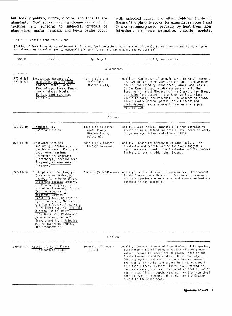
Table 3. Fossils from Atka Island
[Dating of fossils by J. A. Wolfe and R. A. Scott (palynomorphs), John Barron (diatoms), L. Marinkovich and F. H. Wingate (bivalves), Gerta Keller and K. McDougall (foraminifers), and David Rukry (nannofossils)l
Sample
R77-6-3a2 877-6-3a4
Fossils
Lycopodium, Osmunda polyEodl aceae, ~ taxo-
laceae, Ab1es, Lar~ PSeU'd'Otsuga, Pi cea, Pi nus, Tsuga, AI nus ,""""'BetUTa-,--Myri ca ,centrospermae, Erl"'C'aTe s •
877-10-1b Pinnularia sp., Cosc1nodiscus sp.
877-14-2d Freshwater pennates,
779-19-1A
including Pinnularia sp.; benthic mar1ne: Cocconeis spp.; other marine: Grammatophora angulosa (Ehrenberg), Cosc1nod1scus fragment, Rhizosolenia fragment.
Biddulphia aurita (Lyngbye) Brebisson-ana-Godey, B. rhombus (Ehrenberg) Smith,
Cci'C'C'Oiiei s costata Gregory, C. dirupta Gregory, C. scutelTi:iiilEh renberg ,-C. spp. Cosc1nod1scus cf. C.kutZ1ng1i Schmidt,-Ceratulus sp., Endictya sp., Hyalodiscus sp., Melosira clav1gera Grunow, M. sulcata (Ehrenberg) Kutzi ng, fifaVTCUTa directa (Smith) Ralfs, PlnnUTaria sp., Rhabdonema japon1cum var. rectum? Tempere and Rru~os ira maxima (Kutzing) Brunow, ~sionema sp.
799-24-1A Ostrea cf. 0. tigiliana ~kewitsch (1938).
Age (r1.y .) Locality and remarks
Palynomorphs
Late middle and early 1 ate Miocene (R-14).
f)iatoms
Eocene to Holocene (most likely Miocene through Holocene).
Most likely Miocene through Holocene.
Locality: Confluence of Korovin Bay with Martin Harbor. The two pollen assemblages are similar to one another and are dominated by Taxodiaceae, Alnus, and Betula. In the Kenai Group, Taxodiaceae persist into~ lower part (latest M1ocene) of the Clamgulchian Stage, but Abies last occurs in the Homerian Stage (late midrlre-IO early late Miocene). The absence of broadleaved exotic genera (particularly Ulmaceae and ,Juql andaceae) favors a Homeri an rather than a preHomen an age.
Locality: Cape Utalug. Nannofossils from correlative strata on Aml i a Island indicate a 1 ate Eocene to early Oligocene age (Mclean and others, 1983).
Locality: Coastline northwest of Cape Tadluk. The freshwater and benthic marine specimens suggest a nearshore environment. The freshwater pennate diatoms indicate an age no older than Eocene.
Miocene (5.5-24)------ Locality: Northeast shore of Korovin Bay. Environment is shallow marine with a minor freshwater component. Planktic species are very rare, and a more refined age estimate is not possible.
Bivalves
Eocene or Oligocene ( 24-58).
Locality: Coast nortf-Jwest of Cape lltalug. This species, questionably identified here because of poor preservation, occurs in Eocene and Oligocene rocks of the Alaska Peninsula and Kamchatka. It is the only Tertiary oyster that could be described as common on the Alaska Peninsula, and occurs in large numbers in sor1e fossil beds. Oysters always live cemented to hard substrates, such as rocks or other shells, and in modern seas live in depths ranging from the intertidal zone to 35 m, in regions extending from the Equator almost to the polar seas.
Igneous Rocks 9

prehnite, calcite, quartz, sphene, and zeolites as secondary minerals. Other rocks are relatively fresh (for example, samples 2, 4, and 5). The metamorphosed plutonic rocks may represent an earlier intrusive phase, but the age of that suspected event is not known.
Radiometric ages of plutonic rock samples range from 8.5 to 18 m.y. (tables 4, 5). Two zircon
Table 3. Fossils from Atka Island--Continued
Sample Fossils Age (m.y.)
analyses from tonal~\fs of 2:fRe Beaver Bay pluton yielded a concordant Pb/ U age of 15.1±0.1 m.y., which is considered to be an accurate cooling age (table 4; J. M. Mattinson, written commun., 1980). KAr dates from quartz diorite and meladiorite of the same pluton yielded ages of 17.5 and 18.1 m.y., respectively (table 4). K-Ar ages of 13.0 m.y. (biotite) and 11.8 m.y. (plagiocla~e) were obtained on quartz
Locality and remarks
Foraminifers
R77-7-4C
R77-7-3A
R77-7-3F
R77-10-2
Globigerina linaperta Finlay--- Eocene (37-58)-------- Locality: Central north shore of Egg Ray. Thin section contains fragments of unidentifiable planktic foraminifers and rare Globigerina linaperta Finlay, which ranges in age from late Paleocene through Eocene and is most common in the Eocene.
Coccolithus, Dictyococcites, Ret1culofenestra?.
Coccolithus eopelagicus, Cycl1cargol1thus floridanus, Dictyococcites scrippsae, Reticulofenestra sp., among sparse placol1th fragments.
Reticulofenestra, Dictyococcites scripps~ bisectus?, Coccol1thus eopelagicus?.
Nannofossils
Eocene to Pliocene (5.5-58).
Middle Eocene to middle Miocene ( 16-52) 0
Mi dd 1 e Eocene through 1 ower Oligocene (30-52), on the basis of lower-latitude correlations.
Locality: Samples 877-7-3A and 877-7-3F are from the north side of Egg Bay, and sample 877-10-2 is from the northwest shore of Cape Utalug. The best evidence from coccoliths is that the samples are middle Tertiary (not Paleocene or Pliocene). Fragmentation and low diversity indicate that environmental and diayenetic effects are indistinguishable.
Table 4. K-Ar analyses of Atka Island igneous rocks
[l•lhole-rock samples were ground and sieved through 35- and 60-mesh screen. The powder was washed and treated with dilute hydrofluoric acid, then with dilute nitric acid, and briefly placed in an ultrasonic bath. These techniques enhance the radiogenic-argon content and increase precision but do not adversely affect the accuracy of the age determination. Error limits represent estimated ana lyt~ cal precision based on uncertainties in the analyses of K and Ar. Constants used in the calculation of age are: Ae+e'=0.581x1o-1 yr-1, As= 4.91i3x1o-10 yr-1, and 40K/K=l.167xln-4 atom percent]
Average 40Arrad 401\rrad
Sample Location Rock type K 0 Apparent Remarks content (1 o-1 ° mol/g) 40
Artotal age
(wt pet)
877-15-4 Middle of headland Quartz diorite------ n.'iOfi o.onsn 0 .1fi 8.9±0.4 Hornblende separate. between Crescent .506 • 059? .10 8.1±0.8 Do • and Rechevin Rays. 8.5±0.4 Average.
877-9-1 Southwest shore of Rasa l t- ------------- .878 .1408 .28 11.1±0.4 Whole rock. Martin Harbor.
877-15-5 South shore of Rasaltic andesite--- .6?4 .1076 .17 11.9±0.6 Do. Rechevin Ray.
877-14-5-I I West-central shore Tonalite------------ 8.53 1.575 • 63 13.0±0.4 Biotite separate • Sergief Ray. 1.639 .32 --------------------------------
1. 772 .3032 .35 11.8±0.05 Plagioclase separate.
877-12-9 West-central shore Quartz diorite------ 1.131i .2869 .35 17.5±0.07 Whole rock. of Reaver Bay.
877-1?-8 North shore of Mel ad i orite- -------- 4.1i70 1. ~50 .35 18.1±0.8 Biotite separate. Reaver Ray.
10 Reconnaissance Geology of Southern Atka Island, Aleutian Islands, Alaska

diorite of the Sergief Bay pluton; quartz diorite from the Crescent Bay pluton (hornblende) is 8.5 m.y. old. Thus, the plutons appear to young toward the west. The radiometric ages, however, were defermined on relatively fresh and unaltered rocks, and we recognized more highly altered plutonic rocks both in the field and in thin section. Therefore, other, older plutons probably occur on Atka Island. Confirmation of the apparent younging of plutons to the west and the possibility that older plutons occur will require more detailed sampling and dating of a statistically significant number of rocks.
Volcanic rocks
Most of the Tertiary (pre-Korovin volcanic complex) volcanic rocks are basalt, basaltic andesite, and andesite. They are typically porphyritic and contain euhedral phenocrysts of plagioclase, clinopyroxene, and Fe-Ti oxides in a groundmass of secondary minerals. Plagioclase is commonly mottled and partially albitized; in some rocks, it is completely replaced by calcite or prehnite. Pyroxene phenocrysts are generally unaltered, but in some rocks they are completely replaced.
Secondary minerals replace glassy groundmasses, rim or fill vesicles, and fill fractures. Secondary minerals include several types of zeolites,
calcite, chlorite, epidote, prehnite, pumpellyite, and smectite. Radiometrically dated volcanic rocks (!!!ble 4) are extensively altered. Sample 877-9-1 (table 6), for example, contains calcite, smectite, zeolites, and chlorite; other samples are similarly altered.
Massive flows of pale-gray holocrystalline finegrained andesite crop out along the south shore between Vasilief Bay and Sadatanak Island. The rocks are essentially unaltered and form much of the highland area between Kobakof and Vasilief Bays. On the point of land directly north of Sadatanak Island, massive flows of holocrystalline andesite that concordantly overlie relatively unaltered sedimentary rocks grade laterally into discordant intrusive diorite. Field relations and petrographic similarities suggest that the extrusive rocks are comagmatic with the plutonic rocks. Although time did not permit closer examination, we believe that much of the island above 300-m elevation may be composed of these comagmatic middle Miocene andesitic flows and breccia.
Geochemistry
A thorough discussion of the igneous-rock petrogenesis, including alteration, is beyond the scope and purpose of this report and, in fact, should be attempted only after more field relations are
Table 5. IJ-Pb analyses of zircon from tonalite (sample 779-25-1) of the Beaver Ray pluton, Atka Island
[All isotopic compositions normalized to absolute values by means of replicate analyses ~n~ng ~a~· ~Jational ~~rea~ ~f Standards P~ st~~%ards qp,1 to gp,3, Cornman Pb corrections:
Pb/ Pb, 19.0; 2 Pb/ 0 Pb, 15.6. 20 Pb/ Pb ages for the sample are insignificant because of the ~h}ght enrichment of radiogenic Pb and the uncertainty in correc2~gg f8r the common isotope - Pb, although these ages are concordant. Thus, the composite - U/ 6pb age of 15.1±0.1 m.y. should represent an accurate cooling age for the pluton]
Age (rn.y.)
Fraction size 23811 206pb ?08pb 207pb 204pb (ppm} (ppm) 20fiph 20fipb 206pb 206pb 207pb
238u 206pb
Coarse------ 330.8 0.674 0.4188 0.1122 0.004475 15.15±0.15 15±30 Fine-------- 426.8 .861 .2827 .08724 .002754 15.00±0.15 34±?.0
Table fi, Classification, ages, textures, and mineralogy of chemically analyzed Tertiary igneous rocks of Atka Island
[Sample numbers correspond to those in figure 8 and table 7. Ages: P, preplutonic; S, synplutonic; --, not determined. Textures: n, diabasic; F, felty; H, hypidiofT!orphic granular; I, intersertal; P, porphyritic; X, pilotaxitic. Minerals: Act, actinolite; An, analcime; Bio, biotite; Ca, calcite; Chl, chlorite; Cpx, clinopyroxene; Ct, clinoptilolite; Ep, epidote; Gl, glass; H, hornblende; He, heulandite; Hm, hematite; Ol, olivine; Opx, orthopyroxene; Or, orthoclase; Ox, Fe-Ti oxides; Pl, plagioclase; Pr, prehnite; Otz, quartz; Sm, smectite; Sp, sphene; Ze, zeolites. (x), determined by X-ray diffractionl
Sample Field No. Rock type Age (fTI.y.) Texture Primary minerals Secondary minerals Remarks
1 877-13-1A Gabbro------------ H Pl ,Cpx,Ox,Op, Act ,Chl ,Pr ,Otz ,Or(x) Metamorphosed. 2 ,''77-12-9A Hornblende norite- 17 ,'i H Pl ,H,Opx,Bio,Cpx,Ox Ct( x) Relative-ly unaltered. 3 877-12-1 [)i abase----------- [) Pl ,Cpx ,Ox Ch l , P r, Ca , Hm , nt z ( x) , Ze Metamorphosed. 4 877-12-8 Mel ad i ori te------- 18.1 H Pl ,H,Bio,Ox,rJpx Act ,Chl ,Sp Rel ati ve1y una 1 tered. 5 877-14-5II [)11artz diorite---- 12.4 H Pl ,Cpx,Opx,Rio,Otz,H,Ox Act Do. 6 779-::>5-1 Quartz diorite---- 15.1 H Pl ,Bio,H,Qtz,Cpx,Ox,Opx Act no. 7 877-10-58 Basalt------------ p p ,X Pl,Cpx,Ol,Ox Sm,Ca,An(x) ,He(x) Abundant zeo1 i tes. 8 877-9-1 Rasa 1 t- ----------- 11.1 p, X Pl ,Cpx,Ox,Gl ,H,Opx Ca , Sm, Ze, ffn, Ch l Altered. g 779-18-1A Basaltic andesite- p F ,P Pl , Ox Ep,He(x) ,Chl ,Hm,Otz,Sm Highly altered.
10 877-1::>-4 Andesite---------- s I, p Pl , Ox ,Gl Ch1 ,Sm,Ca,Ep,Pr,Sp Metamorphosed.
Igneous Rooks 11

determined and additional laboratory data are available. We can, however, discuss the range of rock compositions, comment on the differentiation trends, and compare the rocks with other rocks from the ·Aleutian Islands.
Tables 6 and 7 list the ranges in composition of the modal mineralogies and chemical analyses, respectively. Si02 contents, corrected for H2o and C02, range from ~7 .5 to 66.3 weight percent (L. A. Morgenson and others, unpub. data, 1983). Al20 3 content is relatively high, similar to that of rocks in
other island arcs (Gill, 1981). Ti02 content ranges widely, from 0.46 to 1.43 weight percent plutonic rocks and from 0.57 to 1.32 weight percent volcanic rocks. The average Ti02 content for 16 mafic rocks (less than 52 weight percent Si02) is 0.82 weight percent. Na2o content ranges widely; some high values are apparently related to zeolitization and (or) albitization. K2o content does not exceed 2.73 weight percent in the plutonic rocks and 1.26 weight percent in the volcanic rocks. In general, the range in Si02 contents, the high A120 3 and low Ti02 contents, and
Table 7. Chemical analyses of representative Tertiary igneous rocks of Atka Island
[Major-element analyses in weight percent; minor-element analyses in parts per million. Major ele~ents and some minor and trace elements determined by X-ray fluorescence, and FeO by wet chemistry; *, determined by neutron activation. Sample numbers correspond to those in table 6. not determined or helow detection limitJ
Sample-----
Si02------- 49.66
TiOz------- 1.17
Al 2o3------ 15.61
Fe2o3------ 4.05 FeO-------- 7.62
MgO-------- 6.00
CaO-------- 9.41
Na 2o------- 3.49
K20-------- .54
P2o5------- .zo H
2o+_______ 1.76
H2o-------- .88
C02-------- .12
Total--- 100.51
Mn--------- 1,208 Rb---------Sr--------Zr--------Cr---------sc*-------
*
~~*=~====~= * Ba --------*
~=*======== *
~~:======== ~r~~~~~~
*
~~*======== *
i~*======== * u ---------
c66 59 89 42 38 31
134 5.02
12.00 10.40 2.72
.9n 3.84
.57 2.12
.35 1.46
.78
.43
2
50.12
.63
14.84
4.fiR
5.71
7.20
10.99
3.fi6
.90
.18
.fi7
.14
.30
100.02
1,805 23
388 37
294 38 27 55
110 9.78
22.30 14.10 3.31
.87 3.21
.47 1.35
.23 1.50
.46 1.7n
.82
3
50.82
.94
16.48
4.30
5.30
5.50
8.10
4.28
1.11
.18
2.39
• 74
.35
100.49
1,053 17
295 104
Clfj
32 31 39
225 6.45
14.50 10.70 2.78
.89 3.34
.55 2.04
.34 1. 70
.11 1.1fi
.fi3
4 5 6
Major-element oxides
52.fi0
.86
19.17
2.91
3.94
5.20
8.6(1
4.~3
.74
.25
1.25
.16
.05
100.08
60.02
.58
16.02
2.31
2.87
4.40
fi.28
4.11
?.OR
.15
.5fi
.50
.09
99.97
fi1.10
.63
1fi .10
1. 55
3.0(1
4.04
5.44
3.61
2.52
.14
.85
.10
.46
99.56
Minor and trace elements
651
fi97 74 75 If; 18 47
194 7. 71
17.50 11. no 2.58 1. 02 2.18
.42 1.3fi
.20 1.07
.fl7
.25
.14
759
403 148 164
18 32 71
128 5.29
13.30 9 • .17 3.12
.98
.56 2.12
.34 1.36
.14 1.09
.69
629 45
501* 181* 119
14 16
388 13.00 27.90 16.60 3.60
.92 3.08
.45 1.50
.22 5.33
.33 3. 72 2.12
48.51
.6fi
14.40
3.89
4.35
7.5()
11.57
4.31
.70
.14
2.11
2.02
.8?
100.98
1,324 11
137 44
397 47 42 71
319 2.12 4.9fi 5.9? 1.53
.58 2.24
.33 1. J 7
.?6
.16
12 Reconnaissance Geology of Southem Atka Island, Aleutian Islands, Alaska
50.08
.87
16.94
3.19
4.63
5.60
11.13
3.52
.75
.17
.03
.83
1.90
1,100 11
40L 67
157 35 26 31
22(1 5.75
13.50 11.30 2.77 1.01 2.4(1
.41 1.47
.24 1.74
.07
.89
.58
g
53.20
.84
21.20
3.53
3.83
1.12
8.95
3.26
.25
.13
2.75
.41
.04
99.53
2,330*
o34
10 ?1 20
fi .13 13.110 9.55 2.45
.83 2.75
.49 1.77
.27 1.8Ll
.09
.98
.5n
10
58.45
.96
15.47
4.44
4.20
3.70
3.?2
5.46
.29
.17
3.10
.63
.37
100.46
1,123
137 74 75 ?I)
23 47
7.45 18.50 13.20 3.89 1.05 4.65
.7P. 3.39
.51) 3.37
.21) 1.29 l.Ofi
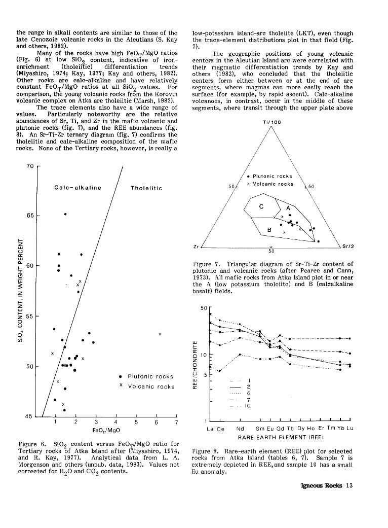
the range in alkali contents are similar to those of the late Cenozoic volcanic rocks in the Aleutians (S. Kay and others, 1982).
Many of the rocks have high FeOT/MgO ratios (Fig. 6) at low Si02 content, indicative of ironenrichment (tholeiitic) differentiation trends (Miyashiro, 1974; Kay, 1977; Kay and others, 1982). Other rocks are calc-alkaline and have relatively constant FeOT/MgO ratios at all Si02 values. For comparison, the young volcanic rocks from the Korovin volcanic complex on Atka are tholeiitic (Marsh, 1982).
The trace elements also have a wide range of values. Particularly noteworthy are the relative abundances of Sr, Ti, and Zr in the mafic volcanic and plutonic rocks (fig. 7), and the REE abundances (fig. 8). An Sr-Ti-Zr ternary diagram (fig. 7) confirms the tholeiitic and calc-alkaline composition of the mafic rocks. None of the Tertiary rocks, however, is really a
70
Calc- alkaline Tholeiitic
65 •
I-' z w u • • a: w a..
60 I- • I • Q • w ~ ~ I--z w I- 55 z 0 u • 0 • X
en • • X
• , X
50
• Plutonic rocks X Volcanic rocks •
2 3 4 5 6 7
Figure 6. Si02 content versus FeOT/MgO ratio for Tertiary rocks of Atka Island after (Miyashiro, 197 4, and R. Kay, 1977). Analytical data from L. A. Morgenson and others (unpub. data, 1983). Values not corrected for H20 and co2 contents.
low-potassium island-arc tholeiite (LKT), even though the trace-element distributions plot in that field (Fig. 7).
The geographic positions of young volcanic centers in the Aleutian Island arc were correlated with their magmatic differentiation trends by Kay and others (1982), who concluded that the tholeiitic centers form either between or at the end of arc segments, where magmas can more easily reach the surface (for example, by rapid ascent). Calc-alkaline volcanoes, in contrast, occur in the middle of these segments, where transit through the upper plate above
50
Ti/1 00
• Plutonic rocks
x Volcanic rocks 50
Figure 7. Triangular diagram of Sr-Ti-Zr content of plutonic and volcanic rocks (after Pearce and Cann, 1973). All mafic rocks from Atka Island plot in or near the A (low potassium tholeiite) and B (calcalkaline basalt) fields.
50
L.LJ
t: a: 0 10 z 0 I u 5 -...__ L.LJ L.LJ a:
· .•.........•.
---.....-
.....,
La Ce
·.·-\~
__.......-- ·'.'. /· ....... ·-···-·-·-·-·-·-·-·-·-·__...·-· --- ...... .......... . - ' . ·. :--..-------------.
_,..... ______ •··-·· ..........
I 2 6 7
- 10
'•·-·. ··- .......
Nd Sm Eu Gd Tb Dy Ho Er Tm Yb Lu
RARE EARTH ELEMENT (REEl
Figure 8. Rare-earth element (REE) plot for selected rocks from Atka Island (tables 6, 7). Sample 7 is extremely depleted in REE, and sample 10 has a small Eu anomaly.
Igneous Rocks 13

a subduction zone is more difficult. The correlation of tectonic position with differentiation trend is more difficult with the older Tertiary rocks because of problems with age determination and because the tectonic regimes change over time in island arcs.
Kay and others {i982) concluded that the similarity between the most primitive basalts from both differentiation series suggests initial crystallization from the same primitive parent magma. Apparently, initial crystallization was along an Fe-enrichment trend that was continuous for the tholeiitic series but was interrupted for the calcalkaline series. Therefore, differences in the style of differentiation can explain these two distinct series.
REGIONAL PATTERNS OF ALTERATION
In all the rock types, the most common secondary minerals are quartz and chlorite. Smectite,
80
60
40 :
20 :
~ 0 «: a: w ~ ::i"
>a: «: 0 z 0
~ U)
~ «: 1-z 0 0 0
1-«: I 1- 60 U)
::.:: 0 0 a: 40
0 U) 20 w (') «: 1- 0 z w 0 a: w 80 0..
60
A
D
zeolites (mainly heulandite, analcime, and laumontite), calcite, pumpellyite, prehnite, epidote, and amphibole also commonly occur (fig. 9). In some sedimentary rocks, secondary calcite occurs as recrystallized foraminifers and nannofossils. Other secondary minerals are alteration products of volcanic debris, vesicle infillings, or cement in sedimentary rocks. Secondary minerals not plotted in figure 9 include kaolinite, albite, hematite, pyrite, goethite, apatite, and sphene.
Secondary minerals suggest that most of the rocks were subjected only to zeolite-facies metamorphism. Albite-epidote-hornfels- and hornblende-hornfels-facies rocks also occur but primarily on the west half of the island (west of Explorer and Banner Bays). Secondary minerals from the west half of Atka are dominated, in decreasing order of abundance, by chlorite, epidote, quartz, prehnite, amphibole, and pumpellyite, whereas those from the east half of Atka are dominated by quartz, chlorite, smectite, heulandite, analcime, laumontite,
8 c
F
EXPLANATION
1 QUARTZ
2 SMECTITE
3 CHLORITE
4 ILLITEICELADONITE
5 STILPNOMELANE
6 LAUMONTITE
7 ANALCIME
8 HEULANDITE
9 THOMSONITE
10 NA TROLITE
11 CHABAZITE
12 MORDENITE
13 ERIONITE
14 STILBITE
15 PHILLIPSITE
16 UNIDENTIFIED ZEOLITE
17 PUMPELLYITE
18 PREHNITE
19 EPIDOTE
20 AMPHIBOLE
21 K-FELDSPAR
22 CALCITE
Figure 9. Alteration products of Atka Island rocks. f:!, All rocks, based on 138 samples. ~' Sedimentary rocks, based on 65 samples. Q, Volcanic and pyroclastic rocks, based on 41 samples. J2, Plutonic rocks, based on 32 samples. §, All rocks from east half of island, based on 81 samples. f, All rocks from west half of island, based on 57 samples. Upper histograms are for only extensively altered rocks; lower histograms are for all altered rocks within each numbered category.
14 Reconnaissance Geology of Southern Atka Island, Aleutian Islands, Alaska

and calcite. Higher grade metamorphic-mineral assemblages on western Atka reflect the influence of the intrusion of plutons there. Even though the higher grade minerals are more abundant to the west, more rocks are extensively altered to the east, 39 versus 55 percent (table 8), assuming that the rocks collected are representative of the bulk of rocks that make up the island. Of all the rocks collected on Atka Island, 48 percent are extensively altered.
Table 8. Percentages of extensively altered rocks of Atka Island
Rock type F.:ast half
Sedimentary-------- 64 Volcanic----------- 49 Plutonic----------- 26 All---------------- 55
West half
42 39 35 39
Whole island
56 45 32 48
The rocks were divided into sedimentary, volcanic and pyroclastic, and plutonic categories. The sedimentary rocks contain the most abundant suite of secondary minerals (56 percent extensively altered) because they are composed of partly altered volcanicrock fragments and are cemented by a variety of authigenic minerals. In contrast, the plutonic rocks include the fewest samples that are extensively altered (32 percent); the volcanic rocks are intermediate (45 percent extensively altered; table 8). Extensive alteration of some of the plutonic rocks, primarily to chlorite, amphibole, and epidote minerals, suggests albite-epidote-hornfels- and, possibly, lower hornblende-hornfels-facies metamorphism at temperatures probably near 350° to 500°C.
In comparison with adjacent Amlia Island (McLean and others, 1983), Atka Island rocks are much more extensively altered-30 versus 48 percent, respectively. The dominant clay mineral on Atka is chlorite, and on Amlia smectite. Amlia rocks contain more zeolites, whereas Atka rocks contain more of the low-grade metamorphic minerals pumpellyite, prehnite, epidote, and amphibole. Again, these differences probably reflect the positions of plutons on Atka Island; none crop out on Amlia.
STRUCTURE
Folds
The overall east-westward trend of Atka Island probably reflects the major structural features of the southern part of the island. As seen in shoreline outcrops, stratified rocks in the southeastern J>art of the island generally strike east-west and dip 10 -20° S. (figs. 2, 3). Dips locally exceed 70° where drag folding has occurred adjacent to faults. A large open anticline that trends northeast-southwest crosses the midpoint of Explorer Bay. Small folds of presumed local extent are common along the southeastern part of the island.
Attitudes of the stratified rocks west of Beaver Bay are more irregular, probably complicated by intrusion of plutonic rocks; however, dips rarely exceed 2 5°. On the north side of the island, beds of massive sandstone and volcanic breccia in Wall Bay strike northwest and dip 35°-55° NE. A thin-bedded sequence of fine-grained sandstone and siltstone exposed on the northeast shore of Egg Bay likewise strikes northwest and dips 65°-80° NE. (fig. 4J:!).
Faults
Faults of presumably small displacement are abundant within the stratified sequences. The dip of most faults is near-vertical, and adjacent strata are little deformed except where drag folding has occurred, for example, along the northeast shore of Egg Bay and northwest of Cape Utalug.
Faulting has created a pronounced east-westtrending topographic lineament that extends from the head of Egg Bay to Atka Village. The fault zone is well exposed in the seacliff just south of the village.
Most faulting appears to be extensional in origin, probably related to the emplacement of plutons in the central and western parts of_ the island, and unrelated to compression associated with plate convergence along the Aleutian Trench.
RESOURCE POTENTIAL
Resources in many island arcs, especially the Aleutian arc, have not been adequately evaluated because most of the arc is under water, because those parts above water generally are associated with active volcanism, and because of logistic problems. Massive sulfides, Kuroko-type deposits, tin, gold, and other mineral deposits, however, are known from the Tertiary rocks of volcanic arcs (for example, Sato, 1977). Atka Island rocks are worthy of extensive studies for economic minerals.
Bottom sediment from seven streams that drain the Beaver Bay pluton were sampled to analyze for concentrations of metals. Sample 779-24-8 (bulk) contains relatively high concentrations of Cu (700 ppm), Pb (300 ppm), and Ag (1.0 ppm) (table 9); sample 779-24-5 (bulk) contains similar enrichments. Sn is high (100 ppm) in one sample (table 9). The average contents of 6 minor elements in 32 igneous rocks of Atka Island are also listed in table 9; these average values are comparable to those in rocks of the Beaver Bay pluton alone. Comparison of the river silt with the igneous rocks clearly shows enrichments of Mn, Cu, Pb, Sn, Ag, and Zn in the silt. Ag content of 1 ppm is an enrichment of 25 times over the average for granite, 10 times over that for basalt, and 14 times over that of average continental crust (Taylor, 1964). Sn at 100 ppm is enriched 33 times over the average for granite, 100 times over that for basalt, and 50 times over that for average continental crust. From these few data, the possibility of ore deposits associated with the Beaver Bay pluton cannot be evaluated, but future explorations should concentrate on the elements listed in table 9; other elements are 'not enriched.
Resource Potential 15

"'0 c: n:l
c: 0 .., :::::l
>, n:l co
r... Q) > n:l Q) co
Q) ..c: .., c: . ,.... Vl Q) Cl n:l c:
n:l r...
"'0
E 0 r...
...... Vl c: 0
.l-)
c: Q) E
" Q) V>
~ 0 u E V>:::::l OE r.._.,.... ..,x Un:l a; E Cl.. V>Q)
c:.D On:l
.,.... .D V>O Ill'
.,.... Cl.. E Q) Q)
..c: >,..,
.D r...
-oo Q)4-c:
E8.. Q) 0..01 .., V> Q)r--.Q)
"'0 :::::l 4-.-
V>On:l .., > c: c: Q)Or... E·.- QJ Q)..,..C: .-u._, Q) Q) 0 .., .-QJQ) .--" .c: c:t: .., ......
o..c: .., "..,.,.... c:•.- 3: n:l E
.-- .,.... Q) V> .-- Cl - n:l Q) r... n:l .c: Q)
..><:..,> .l-) n:l c::C3:
00 ...... .-- .l-) OQ)
.De: V> Q) ~QJVi u r... 0 OQ)..C: r... 3: u
V>V>>, :::::lQJ.--0 ::::::S·rQ) .-- r... c: n:l n:l Cl>r...
.l-) .D.,....
Q)CL.Q > r...
•r- Q) 4'0 V>..C: :::::l..,V> r... n:l .., ...... 3:
V> C: 0 I Q) I ._, NE n:l <::TN Cl.. r.._ N Cl.. n:l ...... Cl.. "OOLD Q) c: Vl 4'0 ,....- M
n:l r... Q) c:
E I >, > n:l Q)
..c:
"'0 c: n:l
c:
Vl .., c:::: Q) .., c: 0 u
.l-)
c: Q) E Q)
Q) I
u
Q)
.D n:l I-
n:ll Q) -l-> I >0..,
.,.... +->·,.... ~ c::( • .§ r... .., X • c: Q) >, 0
Q...,....
000-l-) u u
r... V> Q) 00.., 4-'-QJ ..,-c:' V> u
.,.... a; E Cl..Cl..
Q!V>Cl.. Cl I n:l >,r--r... n:l Q) r... Q) > I ..C: c:t:x._,
>,4-• .D 0
c:::: 0"'04-
.,.... Q) .--
.-C::::n:l ,..... •r- ..c. . ,.... E E r...
Q).D r.._ -l-> CL Q) Q) o..-o E
Cl.. V>VlCl.. ..,, r... 3: cr. n:l Cl....C: ......
u 0 c::::·.-
.,.... ..c. QJ 3: :::::l
Vl Q) ~ n:l :::::l c: >
.-:::E n:l Q) > .l-) Cl
0..11:) ,_Q)r.._ .-UQ) c::CX> L.....! Q) C'O
co I
<:::t N
I
""' ....... .......
....... I
<:::t N
I
""' ....... .......
\0 I
'<:t N
I
""' ...... .......
... , I
<:::t N
I
""' ....... .......
<:::t I
<:::t N
I
""' ...... ......
(V)
I <:::t N
I
""' ...... .......
N I
<:::t N
I
""' ...... ......
I I I I
Q)
Cl.. E n:l
(/)
Q) Cl n:l s... Q) >
c::(
>, > n:l Q) :I:
>, > n:l Qi :I:
>, > n:l Q) :I:
>, > n:l
~
>, > n:l
~
N
oooooo vr--OC...-<0
c.,.....-f 1..{")
N
~ .-<Ocoee·
COOMO r--LDM (V)
N
cooo..-....o vr--o.--< c
c~ ...... (V)
N
N
coocoo vr--.cr--LDO
0 L!)
(V)
N
OOOCLDO voe.o 0
NOr-1 N
~ OOC:::Or--0 vLDCC C
.-<C).-< L!)
ooooeo vr--OMLDO
0 L!)
N
OOOONe VOQOVL.li
r-IL.{)N ......t
~·
000000 vr--oM...-<0
c~ LD
ooe.ONO VLDCMVO
.--<L!) N
oococc vr--cLDCO
C.-<.-<LD
N
COCCLDO vocr-- o
MC N
I I I I I I I I I I I I I I I I I I
I I I I I I Cl:::::lC:L:C:C:
c:t:U::;;:CLU'lN
Small amounts of pyrite are concentrated in the contact zone around the Sergief Bay pluton, in black shale on the west side of Martin Harbor, and occur with goethite, in the fault zone near Atka Village. None of these concentrations of iron is large enough or of high enough grade to warrant development.
Small bodies of hydrothermally deposited silica and iron (now hematite) occur between volcanic flows on tiny Uyak Island in Nazan Bay (table 10). At about 20 weight percent Fe2o3 these deposits are too small and too low in grade for development. Sb at 394 ppm is significantly enriched in these hydrothermal bodiesabout 2,000 times over that of average continental crust, average basalt, and average granite (Taylor, 1964). On Atka Island, Sb averages 0.100 and 0.343 ppm for 8 extrusive and 24 intrusive igneous rocks, respectively; a single anomalously high value of 55 ppm Sb was measured for a basaltic andesite but was not included in the average, which would be 6.99 ppm Sb for the extrusive rocks with it included •
The reservoir and source-rock properties of rocks that crop out on Atka Island show little promise for the generation and accumulation of petroleum. The proximity of the sedimentary rocks to young plutons is responsible in large part for the reduction in porosity and permeability. Offshore basins, however, may show greater promise (Scholl and others, 1975; McCarthy and others, 1984) because. the rocks are less altered and have reservoir potential.
SUMMARY AND CONCLUSIONS
Southern Atka Island consists primarily of middle and late Eocene and early Oligocene (approx 30-50 m.y. old) volcaniclastic rocks deposited in nearshore (probably intertidal) upper slope environments. Deposition occurred on fan-delta, shelf, and Aleutian Ridge summit-basin depositional sites. Sediment transport was by rivers, debris flows, and turbidity currents. Lava flows, pyroclastic deposition, and the intrusion of hypabyssal dikes and sills were contemporaneous. This Eocene and Oligocene sequence is recognizable on many of the Aleutian Islands, and at each site the oldest sequence is datable by fossils (for example, Scholl and others, 1975; Hein and McLean, 1980; McLean and others, 1983; McLean and Hein, 1984). On Adak and some other Aleutian Islands, an older group of gabbroic and basaltic rocks containing minor amounts of intercalated sedimentary rocks also occurs (Citron and others, 1980; Hein and McLean, 1980; Kay and others, 1983). These older rocks, which are part of the initial or early series of Marlow and others, (1973), probably are about 55 m.y • old (Hein and McLean, 1980); the bulk of the Aleutian Ridge formed rapidly during the early Tertiary.
The Paleogene sequence on Atka was intruded by plutons during early, middle, and late Miocene time (18-8 .5 m .y. B.P .). Intrusion of plutons caused albiteepidote- and hornblende-hornfels-facies metamorphism (350°-500°C) of the surrounding rocks on western Atka Island, and zeolite- to prehnite-pumpellyite-facies metamorphism (200°-300°C) of the more distant rocks on eastern Atka Island. Plutons may have been emplaced during three separate periods at about 15
16 Reconnaissance Geology of Southern Atka Island, Aleutian Islands, Alaska

m.y., 12 m.y., and 9 m.y. B.P., but our data are insufficient to confirm this possibility. We also believe that an older group of plutons may occur on the island.
Subaerial to shallow-marine (shelf) sediment and volcanic debris flows were deposited during the
Table 10. Chemical analysis of a silica and hematite hydrothermal deposit (sample 779-18-1C) in Nazan Bay, Uyak Island
[Major-element analyses in weight percent; minor- and trace-element analyses in parts per million. Analytical methods: 1, X-ray fluorescence; 2, neutron activation; 3, emission spectroscopy]
Value
Major-element oxides
Si02--------------- 77.6
Al203-------------- .43
Ti02--------------- .003
Fe2o3-------------- 19.5 MgO---------------- .015
CaO---------------- .30
Na 20--------------- .073
K20---------------- <.02
P20~--------------- .21 MnO---------------- .004
Loss on ignition--- 1.12
Total--------- 99.26
Analytical method
3
1
3
1
?
Minor and trace elements
8-----------------Ra----------------Ce----------------Co----------------Cr----------------Cs----------------Cu----------------Dy----------------Eu----------------r,d----------------La----------------Lu----------------Nb----------------Nd----------------Ni----------------Sb----------------Sc-----------------Sm----------------Sr----------------Tb----------------II---------- --------V-----------------Y-----------------Yb----------------Zn----------------Zr-----------------
50 50 6.2 1. 30 1.6 1.16
20 4.5
.599 4.2 6.87
.631 15 13.0 15
394 3.84 2.97
20 • 7 2 .47
300 70
3. 70 70 78
3 3 2 2 2 2 3 2 ~
2 2 2 3 2 3 ? 2 2 3 2 2 3 3 ~
3 2
Neogene on Atka Island, about 14-7 m.y. B.P., contemporaneously with some of the intrusive activity. Conifer forests, which no longer exist anywhere along the Aleutians, were burned and buried by volcanic avalanches and flows. Black carbonaceous shale, containing mostly terrestrial plant debris, accumulated in small subaerial basins containing stagnant water. Neogene igneous plugs and dikes subsequently intruded the sections about 6 m.y. B.P. Synplutonic sedimentary rocks were also altered, mostly to zeolite facies but, in places, to higher metamorphic grades. Secondary quartz and chlorite are ubiquitous in Atka Island rocks.
The Miocene, especially the middle Miocene, was a time of extensive and voluminous igneous activity along the entire Aleutian Island arc (Coats, 1952, 1962; Marlow and others, 1973; Scholl and others, 1976; Hein and others, 1978). Middle Miocene plutons and contemporaneous volcanic rocks, like those on Atka Island, are known from many of the Aleutian islands (Citron and others, 1980). For example, middle Miocene plutons intrude the volcaniclastic rocks on Adak, Unalaska, and Kagalaska Islands (Carr and others, 1970; Marlow and others, 1973) in the Aleutian chain. Middle Miocene volcanic rocks exclusive of plutonic rocks occur on Shemya Island (Cameron and Stone, 1970). An older plutonic event of Oligocene age (approx 32-30 m.y. B.P.) recorded in rocks only on Adak (Citron and others, 1980) and Umnak Islands (McLean and Hein, 1984), and, possibly, on Amlia Island, has not been found on Atka Island, although volcanism occurred at that time on Atka Island; we believe that with detailed mapping it may also be found on Atka Island. Two much older episodes of plutonism are recorded in the rocks at the east end of the Alaska-Aleutian Range batholith (early and middle Jurassic and late Cretaceous and early Tertiary; Reed and Lanphere, 1973), but not on any of the Aleutian islands.
· Thus, igneous events recorded on Atka Island include major Eocene and Oligocene volcanism (approx 50-30 m.y. B.P.), major early, middle, and late Miocene plutonism and volcanism (18-8 m.y. B.P.), and latest Miocene through Holocene volcanism which includes the Korovin volcanic complex of the northern part of Atka Island.
A higher metamorphic grade is observed in rocks from Atka Island relative to adjacent Amlia Island to the east, where plutons do not crop out. Whereas zeolites and smectite dominate on most of Amlia Island, prehnite, pumpellyite, epidote, amphibole, and chlorite dominate on Atka. Some plutons of Atka were extensively altered, primarily to chlorite, amphibole, and epidote, indicative of albiteepidote- and hornblende-hornfels-facies metamorphism. Similar degrees of metamorphism were noted · for Adak Island (Paleogene) plutons and adjacent rocks 175 km west of Atka (Hein and McLean, 1980; Kay and others, 1983). As with the Eocene and Oligocene sedimentary rocks on Adak and Amlia Islands, the rocks on Atka show styles of deformation and · metamorphism, and textures of sandstones, that indicate only shallow levels of burial without regional metamorphism. Alteration and metamorphism result from hydrothermal activity that is driven by shallowseated plutons and, locally, by dikes and sills.
Summary and Conclusions 17

Gentle open folds and extensional faulting are related to the emplacement of plutons and not to compression associated with plate convergence along the Aleutian Trench. The dominant tectonic regime since the Eocene has been mild extension and highangle normal faulting. As on Amlia and Umnak Islands (McLean and others, 1983; McLean and Hein, 1984), little vertical tectonic movement during the Holocene is indicated by the undeformed wave-cut terraces.
RHFHRHNCF.S CITED
Byers, F. M., Jr., 1961, Petrology of three volcanic suites, Umnak and Bogoslof Islands, Aleutian Islands, Alaska: Geological Society of America Bulletin, 72, no. 1, p. 93-128.
Cameron, C. P., and Stone, D. B., 1970, Outline geology of the Aleutian islands with paleomagnetic data from Shemya and Adak Islands: Anchorage, University of Alaska, Geophysics Institute Research Report U AG R-213, 153 p.
Carr, W. J., Quinlivan, W. D., and Gard, L. M., Jr., 1970, Age and stratigraphic relations of Amchitka, Banjo Point, and Chitka Point Formations, Amchitka Island, Aleutian Islands, Alaska, in Cohee, G. V., Bates, R. G., and Wright, W. B., Changes in stratigraphic nomenclature by the U.S. Geological Survey, 1969: U.S. Geological Survey Bulletin 1324-A, p. A16-A22.
Citron, G. P., Kay, R. W., Kay, S. M., Snee, L. w., and Sutter, J. F., 1980, Tectonic significance of early Oligocene plutonism on Adak Island, central Aleutian Islands, Alaska: Geology, v. 8, no. 8, p. 375-379.
Coats, R. R., 1952, Magmatic differentiation in Tertiary and Quaternary volcanic rocks from Adak and Kanaga Islands, Aleutian Islands, Alaska: Geological Society of America Bulletin, v. 63, no. 5, p. 485-514.
--1962, Magma type and crustal structure in the Aleutian arc, in Macdonald, G. A., and Kuno, Hisashi, eds., The crust of the Pacific Basin: American Geophysical Union Geophysical Monograph 6 (National Academy of SciencesNational Research Council Publication 1035), p. 92-109.
DeLong, S. E., 1974, Distribution of Rb, Sr, and Ni in igneous rocks, central and western Aleutian Islands, Alaska. Geochimica et Cosmochimica Acta, v. 38, no. 2, p. 245-266.
Gill, James, 1981, Orogenic andesites and plate tectonics: Berlin, Springer-Verlag, 390 p.
Grewingk, Constantin, 1850, Beitrag zur Kenntniss der orographischen und geognostischen Beschaffenheit der Nord-west- Kiiste Amerikas mit den anliegenden Inseln [Contribution to knowledge of the orographic and geognostic character of the northwest coast of America and the adjacent islands]: St. Petersburg, KaiserlichRussische Mineralogische Gesellschaft Verhandlungen, 1849-50, p. 76-424.
Hein, J. R., and McLean, H., 1980, Paleogene sedimentary and volcanogenic rocks from Adak Island, central Aleutian Islands, Alaska: U.S.
Geological Survey Professional Paper 1126-E, 16 p.
Hein, J. R., Scholl, D. W., and Miller, Jacqueline, 1978, Episodes of Aleutian Ridge explosive volcanism: Science, v. 199, no. 4325, p. 137-141.
Kay, R. W., 1977, Geochemical constraints on the origin of Aleutian magmas, in Talwani, Manik, and Pitman, W. C., m, eds.,Island arcs, deep sea trenches, and back-arc basins: Washington, American Geophysical Union, p. 229-242.
--1978, Aleutian magnesian andesites-melts from subducted Pacific Ocean crust: Journal of Volcanology and Geothermal Research, v. 4, no. 1-2, p. 117-132.
Kay, R. W., Sun, S.-S., and Lee-Hu, C.-N., 1978, Pb and Sr isotopes in volcanic rocks from the Aleutian Islands and Pribilof Islands, Alaska. Geochimica et Cosmochimica Acta, v. 42, no. 3, p. 263-273.
Kay, S. M., 1984, Metamorphism in the Aleutian arc: The Finger Bay pluton, Adak Island, Alaska: Canadian Mineralogist [in press].
'Kay, S. M., Kay, R. W., Brueckner, H. K., and Rubenstone, J. L., 1983, Tholeiitic Aleutian arc plutonism: The Finger Bay pluton, Adak, Alaska: Contributions to Mineralogy and Petrology, v. 82, no. 1, p. 99-116.
Kay, S. M., Kay, R. W., and Citron, G. P., 1982, Tectonic controls on tholeiitic and calc-alkaline magmatism in the Aleutian arc: Journal of Geophysical Research, v. 8 7, no. B5, p. 40 51-4072.
Marlow, M. S., Scholl, D. W ., Buffington, E. C., and Alpha, T. R., 1973, Tectonic history of the western Aleutian arc: Geological Society of America Bulletin, v. 84, no. 5, p. 1555-1574.
Marsh, B. D., 1976, Some Aleutian andesites: Their nature and source: Journal of Geology, v. 87, no. 1, p. 27-45.
--1982, The Aleutians, in Thorpe, R. A., ed., Andesites: Orogenic andesites and related rocks: New York, John Wiley & Sons, p. 99-114.
McCarthy, Jill, Stevenson, A. J., Scholl, D. W ., and Vallier, T. L., 1984, Perspective remarks on the petroleum geology of the Aleutian accretionary body: Marine and Petroleum Geology, v. 2 [in press].
McLean, Hugh, and Rein, J. R., 1984, Paleogene geology and chronology of southwestern Umnak Island, Aleutian Islands, Alaska: Canadian Journal of Earth Sciences [in press].
McLean, Hugh, Hein, J. R., and Vallier, T. L., 1983, Reconnaissance geology of Amlia Island, Aleutian Islands, Alaska: Geological Society of America Bulletin, v. 94, no. 8, p. 1020-1027.
Miyashiro, Akiho, 1974, Volcanic rock series in island arcs and active continental margios: American Journal of Science, v. 274, no. 4, p. 321-355.
Pearce, J. A., and Cann, J. R., 1973, Tectonic setting of basic volcanic rocks determined using trace element analyses: Earth and Planetary Science Letters, v. 19, no. 2, p. 290-300.
Perfit, M. R., Brueckner, H. K., Lawrence, J. R., and Kay, R. W., 1980, Trace element and isotopic variations in a zoned pluton and associated rocks, Unalaska Island, Alaska: A model for
18 Reconnaissance Geology of Southern Atka Island, Aleutian Islands, Alaska

fractionation in the Aleutian calc-alkaline suite: Contributions to Mineralogy and Petrology, v. 73, no. 1, p. 69-87.
Reed, B. L., and Lanphere, M. A., 1973, AlaskaAleutian range batholith: Geochronology, chemistry, and relation to circum-Pacific plutonism: Geological Society of America Bulletin, v. 84, no. 8, p. 2583-2610.
Sa to, Takeo, 1977, Kuroko deposits: Their geology, geochemistry, and origin, in Volcanic processes in ore genesis: Geological Society of London Special Publication 7, p. 153-161.
Scholl, D. W., Greene, H. G., and Marlow, M.S., 1970, Eocene age of the Adak 'Paleozoic(?)' rocks, Aleutian Islands, Alaska: Geological Society of America Bulletin, v. 81, no. 12, p. 3583-3592.
Scholl, D. W ., Marlow, M. S., and Buffington, E. C., 1975, Summit basins of Aleutian Ridge, North Pacific: American Association of Petroleum Geologists Bulletin, v. 59, no. 5, p. 799-816.
Scholl, D. W ., Marlow, M. S., MacLeod, N. S., and Buffington, E. C., 1976, Episodic Aleutian Ridge igneous activity: Implications of Miocene and younger submarine volcanism west of Buldir Island: Geological Society of America Bulletin, v. 87, no. 4, p. 547-554.
Streckeisen, Albert, 1976, To each plutonic rock its proper name: Earth Science Review, v. 112, no. 1, p. 1-33.
--chairman, 1979, Classification and nomenclature of volcanic rocks, lamprophyres, carbonatites, and melilitic rocks: Recommendations and suggestions of the lUGS Subcommission on the Systematics of Igneous Rocks: Geology, v. 7, no. 7' p. 331-335.
Taylor, S. R., 1964, Abundance of chemical elements in the continental crust: A new table: Geochimica et Cosmochimica Acta, v. 28, no. 8, p. 1273-1285.
References Cited 19

GPO 787-042/118