Recommendations for installation and general overview · PDF fileRecommendations for...
15
Roux C. (CNRS UMR5600 - Plateforme ISIG & SedAlp, Sediment Management in Alpine basins) Recommendations for installation and general overview of available tools User guide for FluvialCorridor toolbox How to cite : Roux., C., Alber, A., Bertrand, M., Vaudor, L., Piégay, H., 2013. General Overview guideline for the FluvialCorridor toolbox, a new ArcGIS toolbox package for exploring multiscale riverscape at a network scale. Sedalp (Sediment Management in Alpin Basins) and CNRS (UMR5600).
Transcript of Recommendations for installation and general overview · PDF fileRecommendations for...

Roux C. (CNRS UMR5600 - Plateforme ISIG & SedAlp, Sediment Management in Alpine basins)
Recommendations for installation and general overview of available tools
User guide for FluvialCorridor toolbox
How to cite : Roux., C., Alber, A., Bertrand, M., Vaudor, L., Piégay, H., 2013. General Overview guideline for the FluvialCorridor toolbox, a new ArcGIS toolbox package for exploring multiscale riverscape at a network scale. Sedalp (Sediment Management in Alpin Basins) and CNRS (UMR5600).

Roux C. (CNRS UMR5600 - Plateforme ISIG & SedAlp, Sediment Management in Alpine basins)
FluvialCorridor package for ArcGIS Version V01 - 2014
CNRS - UMR5600 Environnement Ville Société Alpine Space Program - Sedalp
For each use of the FluvialCorridor GIS package leading to a publication, a report, a talk presentation or any other document, please refer to the following paper : Roux, C., Alber, A., Bertrand, M., Vaudor, L., Piégay, H., submitted. "FluvialCorridor" : A new ArcGIS package for multiscale riverscape exploration. Geomorphology.

Roux C. (CNRS UMR5600 - Plateforme ISIG & SedAlp, Sediment Management in Alpine basins)
1
I. Introduction
The present guideline is an overview of the FluvialCorridor toolbox. It describes all the installation process and a quick description of how the different tools can be used. For more details on a specific tool, you can read the associated guidelines (see below the list).
I.1. Context
From several decades, both scientists and managers have an increasing focus on the processes involve in fluvial systems and the assessment of their biophysical status. In this research and operational context, the fluvial corridor concept appears to be justified and highly meaningful. This biophysical continuum of the fluvial systems can be defined as an “area of expression” of a stream according to its history, its biodiversity, its environmental interactions, its biophysical status and its adjustment pattern. Catchment characterization (delineation, detection of stream network, etc.) is today available thanks to a set of GIS toolboxes (e.g. ArcHydroTools or some toolboxes contained into the ArcToolbox package of ArcGIS such as SpatialAnalyst). However, there is currently no tool still available to characterize fluvial corridors. But today, it is an important issue for river scientists and managers in charge of providing a characterization of biophysical status of river network to get a better understanding of the sediment fluxes processes involved in catchments and to improve recommendations about sediment management and river conservation and restoration at a catchment scale.
I.2. Partnership The FluvialCorridor toolbox has been developed to answer this emergent need. SedAlp (for Sediment Management in Alpine Basin : integrating sediment continuum, risk mitigation and hydropower) is a part of a global European cooperation program grouping several alpine countries with a common objective : promote the regional development in a sustainable way. SedAlp project works on an integrated management of the sediment transport into the alpine basins. The development of this toolbox has been made within the UMR 5600 “Environnement Ville Société”, at the École Normale Supérieure of Lyon (France).

Roux C. (CNRS UMR5600 - Plateforme ISIG & SedAlp, Sediment Management in Alpine basins)
2
II. Installation
To ensure an optimal and operational functioning, FluvialCorridor toolbox requires some additional components to be installed. This installation is quick and easy. FluvialCorridor has been developed for ArcGIS 10.0 and ArcGIS 10.1. Installation processes are so detailed for those versions and have not been tested for others versions.
II.1. FluvialCorridor toolbox After downloading, the toolbox is in a .zip file, openable thanks to free software available on the internet such as 7Zip (Fig. 1). All the content can be extracted in a path. Once the content is extracted, each file relates to a different tool of the toolbox. The file that enable to link scripts within the ArcGIS environment is “FluvialCorridor.tbx”.
Figure 1 Extraction of the "FluvialCorridor" zipped file.
In ArcToolbox, the ArcGIS toolboxes manager, right-click on “ArcToolbox” and choose “Add a toolbox ...” (Fig. 2A). Then, go to find the “FluvialCorridor.txb” file into the correct path. (Fig. 2B).
(A)
(B)
Figure 2 FluvialCorridor toolbox installation. (A) : Add a new toolbox in ArcToolbox and (B) : choice of the “FluvialCorridor.tbx” path.
Roux C. (CNRS UMR5600 - Plateforme ISIG & SedAlp, Sediment Management in Alpine basins)
3
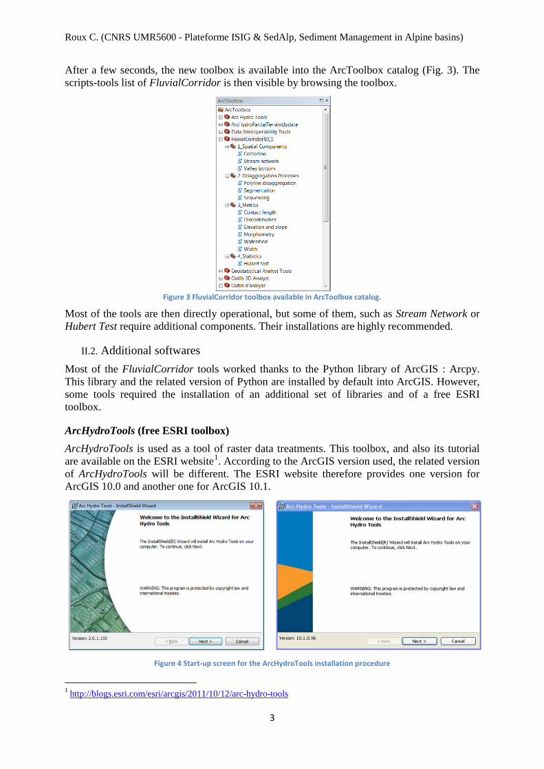
After a few seconds, the new toolbox is available into the ArcToolbox catalog (Fig. 3). The scripts-tools list of FluvialCorridor is then visible by browsing the toolbox.
Figure 3 FluvialCorridor toolbox available in ArcToolbox catalog.
Most of the tools are then directly operational, but some of them, such as Stream Network or Hubert Test require additional components. Their installations are highly recommended.
II.2. Additional softwares Most of the FluvialCorridor tools worked thanks to the Python library of ArcGIS : Arcpy. This library and the related version of Python are installed by default into ArcGIS. However, some tools required the installation of an additional set of libraries and of a free ESRI toolbox.
ArcHydroTools (free ESRI toolbox) ArcHydroTools is used as a tool of raster data treatments. This toolbox, and also its tutorial are available on the ESRI website1. According to the ArcGIS version used, the related version of ArcHydroTools will be different. The ESRI website therefore provides one version for ArcGIS 10.0 and another one for ArcGIS 10.1.
Figure 4 Start-up screen for the ArcHydroTools installation procedure
1 http://blogs.esri.com/esri/arcgis/2011/10/12/arc-hydro-tools

Roux C. (CNRS UMR5600 - Plateforme ISIG & SedAlp, Sediment Management in Alpine basins)
4
Once the corresponding file is downloaded, double-click on the file “ArcHydroTools_XXmsi”. It will start the installation process (Fig. 4). This process is entirely detailed for ArcGIS 10.0 in the attached document “Arc Hydro Tools 2.0 - Tutorial.pdf”. The process with ArcGIS 10.1 is exactly the same.
When the installation is done, and if that is not the case, the ArcHydroTools toolbox must be add into the ArcToolbox catalog to ensure a link with the FluvialCorridor tools. This can be done by repeating the same process than for FluvialCorridor. In ArcToolbox, right-click on “ArcToolbox” and choose “Add a toolbox ...”. Then, open “Arc Hydro Tools.tbx” and “Arc Hydro Partial Terrain Update.tbx”2.
Figure 5 Adding the Arc Hydro Toolbox into the ArcToolbox catalog
NumPy and SciPy libraries Numpy and Scipy libraries encapsulate many Python libraries. Here, they are used to implement some mathematical operations on numerical datasets and statistical treatments (e.g. scipy.stats.mstats.mquantiles function). A lot of versions of those libraries exist. The development of the FluvialCorridor toolbox has been made with Numpy.1.6.1 and Scipy.0.10.1, compatible with the Python 2.6 used into ArcGIS 10.0. Those versions are available thanks to the tab “Download” of the Scipy’s website3 :
‐ For Windows 32 bits : http://sourceforge.net/projects/numpy/files/NumPy/1.6.1/ http://sourceforge.net/projects/scipy/files/scipy/0.10.1/
‐ For Windows 64 bits : http://www.lfd.uci.edu/~gohlke/pythonlibs/
If ArcGIS 10.1 is used, the corresponding version of Python will be the 2.7. In that case, it is recommended to install the “superpacks” of Numpy and Scipy listed in the links above.
Extensions For an optimal functioning of the FluvialCorridor toolbox, some extensions of ArcGIS have to be activated, especially SpatialAnalyst. It is highly recommended to activate all the available extensions into the tabs “Customize”, “Extensions ...” of ArcGIS. 2 “Arc Hydro Partial Terrain Update.tbx” is only available with the ArcGIS 10.1 version of ArcHydroTools 3 http://www.scipy.org/

Roux C. (CNRS UMR5600 - Plateforme ISIG & SedAlp, Sediment Management in Alpine basins)
5
II.3. Tools’ descriptions Once the FluvialCorridor toolbox and the additional components are installed, the 11 scripts-tools of the toolbox are functional. Those tools, described in the Table 1, can be listed into 4 groups :
‐ Extraction of the spatial entities ‐ Disaggregation process ‐ Metrics calculation ‐ Statistics and identification of longitudinal discontinuities
The toolboxes have been developed as a workflow to enable and ergonomize fluvial corridor characterization at network scale (Fig. 6), from the extraction of the main spatial units (stream network, valley bottom, and centerline) to the identification of homogeneous reaches according to a given metric. However, each tool of the present toolbox can be used separately to answer a specific question : for example, the tool to extract the centerline can create a reference axis for the alluvial corridor in order to enable the metrics assessment. But it can also be used in batch mode on an entire set of polygons representing fluvial corridor reaches.
Figure 6 General workflow for the fluvial corridor characterization (Modified from Alber and Piégay, 2011).
Tools Description Stream network
extraction of the stream network from a Digital Elevation Model (DEM) and, if the user wants, from a pre-existing stream network.
Valley bottom extraction of the valley bottom with a DEM and a stream network.
Centerline extraction of the centerline of a polygon entity.
Sequencing orientation and ordination of the stream network or a centerline network
Segmentation disaggregation, with a user-given constant step, of polyline or polygon entities.
Polyline disaggregation extraction of the inflection points and the inflection line of a linear network.
Spatial units extraction (stream network, valley bottom, etc.)
Aggregation into homogeneous reaches according a given metric
Disaggregation and metric assessments (width, sinuosity, confinement index, etc.)

Roux C. (CNRS UMR5600 - Plateforme ISIG & SedAlp, Sediment Management in Alpine basins)
6
Morphometry calculation of morphometric attributes (i.e. half-amplitude, half-length, bend-length and sinuosity) over a linear network thanks to the related inflection line.
Elevation and slope
calculation of a set of topological metrics such as the elevation and the slope over a linear network, using a DEM.
Watershed calculation of the drainage area along a network.
Width calculation, at a user-given constant step, of the width of polygon such as the valley bottom or the active channel.
Contact length calculation, at a user-defined constant step, of the downstream contact length between two different ecosystems into an active channel.
Discontinuities
calculation of the ratio between two consecutive values contained into two neighbouring segments resulting from a disaggregated polyline or polygon. The resulting information is reported into a new shapefile of points corresponding to the boundary of segments.
Hubert test
identification of discontinuities into a data set based on the statistical test of Hubert. This tool is especially used to discretize polyline (e.g. stream network) or polygon (e.g. valley bottom) entities into homogeneous reaches according to a given metric.
Table 1 Descriptive list of the contained tools classified into 4 groups : red, extraction of spatial units - grey, disaggregation processes - green, metrics assessments - yellow, statistics and longitudinal discontinuity identifications
II.4. General terms of use Types of data Each tool requires a set of specific parameters. They can be :
‐ vector data ‐ raster data ‐ booleans ‐ strings ‐ integers
For parameters that are not layer (booleans, strings and integers), there is no ambiguity about the input format. However, the vector or raster data can have several input format. It can be the entire string path to the file or only the name of the layer when it is displayed into an ArcGIS session. Those two options can be run by the FluvialCorridor tools. So, data can be stored either into a geodatabase or a simple path. Only one tool imposes restriction about the format of the input parameters : the Stream network tool. Further explanations are in the related technical guide.
Batch executions All the FluvialCorridor tools allow a batch mode use. That kind of processing can be extremely useful when we want to apply a same tool to an important set of data. Just right-click on the desired tool and select “batch”. Utilization is then the same than for all the ArcGIS tools used in batch mode.

Roux C. (CNRS UMR5600 - Plateforme ISIG & SedAlp, Sediment Management in Alpine basins)
7
III. General user interface Starting the tools Start-up screen of a tool is the same than ArcGIS tools (Fig. 7A). Each tool is directly describe into this interface, firstly in a general overview, and then with more details according to the currently selected parameter (Fig. 7B and 7C).
(A)
(B)
(C)
Figure 7 Start-up screen of the FluvialCorridor tools : example of the Ecotone tool (A). More details are available for each field by clicking on them (B and C).
Processing the tools During all the processing, a progressing window is opened (Fig. 8) and freeze ArcGIS. Some information is provided about the state of the process.
Figure 8 Process screen of the Stream network tool
IV. Script modifications
Scripts modifications can be made, according to a perfect understanding of the algorithmic scheme of the related tool and of Python language and Arcpy library.
In order to add a modification :

Roux C. (CNRS UMR5600 - Plateforme ISIG & SedAlp, Sediment Management in Alpine basins)
8
‐ open the .py file of the related tool into an IDE (Integrated Development Environment) such as Eclipse ou IDLE. This file is contained into the path where the file “FluvialCorridor.zip” has been unzipped.
‐ or, in the ArcToolbox catalog, right-click on the related tool and choose “Modify ...”. The script will be opened into the Windows text editor.

Roux C. (CNRS UMR5600 - Plateforme ISIG & SedAlp, Sediment Management in Alpine basins)
1
V. Test database
The FluvialCorridor package is provided with a test database contained into the “testDatabase” zipped file. It is divided in two subsets : “rawData” and “results”. All the shapefiles and rasters are projected with the French Lambert_93 coordinates system. The Table 2 describes each of them. Data name Shape Nature Tool used Input data used Comments
raw
Dat
a
activeChannel polygon Active channel with water surfaces and bars.
- - Extracted from the BD Topo® database of the IGN1.
agreeStream polyline Hydrographical network. - - Rectified from the BD Topo®
database.
outlet point
Extreme downstream point of the hydrographical network.
- - -
rawDEM DEM raster
DEM of the study area. - - Resolution : 25x25m
resu
lts
burnedDEM raster rawDEM burned with the agreeStream.
Stream network .rawDEM .agreeStream
Default value of the streamburning step have been used.
filledDEM raster Filled raster from burnedDEM.
Calculated from the filled burnedDEM
flowDir raster Flow direction raster over the study area.
flowAcc raster Flow accumulation raster over the study area.
streamNetowrk polyline Hydrographical network.
Stream network initiates with a drainage area of 10km²

Roux C. (CNRS UMR5600 - Plateforme ISIG & SedAlp, Sediment Management in Alpine basins)
2
Data name Shape Nature Tool used Input data used Comments re
sults
valleyBottom polygon Valley bottom over the study area. Valley bottom .streamNetwork
.filledDEM
Parameters used to extract the valley bottom : . “Smoothing tolerance” : 1 000m .“Large buffer size” : 1 500m .“Small buffer size” : 50m .“Disaggregation step” : 50m .“Threshold MIN” : -1m .“Threshold MAX” : 11m
Parameters used to clean the valley bottom : .“Aggregation distance” : 300m .“Minimum area” : 300 000m² .“Minimum hole size” : 200 000m² .“Smoothing valley bottom” : 100m
centerline polyline Centerline network of the valley bottom. Centerline .valleyBottom
.rawStreamNetwork
Generated from the valley bottom shapefile, with a disaggregation step of 5m and smoothing tolerance of 20m.
streamNetwork_Seq polyline Sequenced stream network.
Sequenced .streamNetwork .outlet
-
streamNetwork_Nodes point
Nodes of the stream network (i.e. sources, links and outlet).
-
centerline_Seq polyline Sequenced centerline network.
Sequenced .centerline .outlet
-
centerline_Nodes point
Nodes of the centerline network (i.e. sources, links and outlets).
-
streamNetwork_DGO polyline DGO-scale stream network. Segmentation .streamNetwork_Seq Spatial disaggregation of the stream
network at a 100m-scale.

Roux C. (CNRS UMR5600 - Plateforme ISIG & SedAlp, Sediment Management in Alpine basins)
3
Data name Shape Nature Tool used Input data used Comments re
sults
inflectionPoints point Inflection points of streamnetwork_Seq
Polyline disaggregation .streamNetwork_Seq
Set of inflection points used to created the DGO-scale inflectionNetwork_DGO. .“Minimum area” : 500m
inflectionNetwork_DGO polyline DGO-scale inflection network.
Spatial disaggregation of the inflection network. inflectionNetwork_DGO is a disaggregated network created thanks to the inflection points of streamNetwork_Seq : an inflection line is built between each points.
valleyBottom_DGO polygon DGO-scale valley bottom. Segmentation .valley bottom
.centerline_Seq Spatial disaggregation of the valley bottom at a 100m-scale.
m_contactL polygon
DGO-scale valley bottom attributed with the contact length metric.
Contact length .activeChannel .valleyBottom_DGO -
m_elevationSlope polyline
DGO-scale stream network attributed with the elevation and slope metrics.
Elevation and slope
.streamNetwork_DGO
.rawDEM -
m_morphometrySN polyline
DGO-scale stream network attributed with morphometric information.
Morphometry .streamNetwork_Seq .inflectionNetwork_DGO .inflectionPoints
Morphometric information written into the DGO-scale stream network. .“Report results” : On both
m_morphometryIN polyline
DGO-scale inflection network attributed with morphometric information.
Morphometric information written into the DGO-scale inflection network. “Report results” : On both

Roux C. (CNRS UMR5600 - Plateforme ISIG & SedAlp, Sediment Management in Alpine basins)
4
Data name Shape Nature Tool used Input data used Comments re
sults
m_watershedSN point
Points overlaying the DGO-scale valley bottom and attributed with the watershed area.
Watershed .streamNetwork_DGO .flowAcc -
m_watershedVB point
Points overlaying the DGO-scale valley bottom and attributed with the watershed area.
Watershed .valleyBottom_DGO .flowAcc -
m_widthAC point
Points overlying the DGO-scale centerline network attributed with the active channel width.
Width .activeChannel .centerline
Active channel width calculated along the centerline network each 50m.
m_widthVB point
Points overlying the DGO-scale centerline network attributed with the active channel width.
Width .valleyBottom .centerline
Valley bottom width calculated along the centerline network each 50m.
valleyBottom_DGO_width polygon
DGO-scale valley bottom attributed with the width metrics.
- .m_widthVB .m_widthAC .valleyBottom_DGO
Valley bottom and active channel width metrics transferred into the DGO-scale valley bottom thanks to a spatial join.
streamNetwork_AGO_sinuo polyline
AGO-scale stream network aggregated according to the sinuosity.
Hubert test .m_morphometrySN
Spatial aggregation of the stream network : homogeneous reaches in terms of sinuosity. .“Alpha” : 0.05 .“NoData value” : 0

Roux C. (CNRS UMR5600 - Plateforme ISIG & SedAlp, Sediment Management in Alpine basins)
5
Data name Shape Nature Tool used Input data used Comments re
sults
valleyBottom_AGO_widthAC polygon
AGO-scale valley bottom aggregated according to the active channel width.
Hubert test .valleyBottom_DGO_width
Spatial aggregation of the stream network : homogeneous reaches in terms of active channel width. .“Alpha” : 0.05 .“NoData value” : 0
valleyBottom_AGO_widthVB polygon
AGO-scale valley bottom aggregated according to the valley bottom width.
Hubert test .valleyBottom_DGO_width
Spatial aggregation of the stream network : homogeneous reaches in terms of valley bottom width. .“Alpha” : 0.05 .“NoData value” : 0
discontinuities_sinuo_DGO point Break points along the DGO-scale inflection network.
Discontinuities .m_morphometryIN
Extraction of discontinuities along the DGO-scale inflection network. Each break points is attributed with the ratio of sinuosity values of the two surrounding DGOs.
discontinuities_ACwidth_AGO point Break points along the AGO-scale valley bottom.
Discontinuities .valleyBottom_AGO_widthAC
Extraction of discontinuities along the AGO-scale valley bottom, aggregated according to the active channel width. Each break points is attributed with the ratio of active channel width values of the two surrounding AGOs.