REC 13 RESERVOIR ACCESS/FACILITY ASSESSMENT · areas closed to public ... Recreation Resources REC...
27
Copyright 2004 by Southern California Edison Company REC13-1 REC 13 RESERVOIR ACCESS/FACILITY ASSESSMENT 1.0 EXECUTIVE SUMMARY Project reservoirs provide diverse recreational opportunities in the Upper San Joaquin River Watershed. The maintenance of appropriate reservoir access is a primary consideration in providing water-based activities, and other recreational opportunities. These reservoirs support various water-based recreation activities and may serve as an origination point for non-water-based recreation activities around the reservoirs such as day-hiking, picnicking and camping. The primary focus of the study is the major reservoirs within the Big Creek ALP study area: Shaver Lake, Huntington Lake, Mammoth Pool Reservoir, and Florence Lake. All reservoirs have developed public access points with associated support facilities. Each reservoir has multiple levels of access ranging from unrestricted vehicular access to areas closed to public access. The extent and type of development at each reservoir is closely associated with the level of use at the reservoir and the overall character of the recreational setting. At Huntington and Shaver Lakes there are several developed access points and numerous support facilities around the lakes. These areas have been developed to support large numbers of users engaged in a variety of recreational activities. At Mammoth Pool Reservoir and Florence Lake, the approach to development reflects the setting and level of use. At each of the latter referenced lakes there is a single primary developed access point, and a relatively low level of facility development around the lakes. This level of development is consistent with the “remote” character of these areas and the primary on-water activity, which is angling. Survey data obtained from the implementation of the REC 10 Recreation Opportunities and Needs Assessment and REC 17, Dispersed Recreation Opportunities and Needs Assessment study plans (SCE 2001) was used to summarize user satisfaction attitudes relative to access, and the facilities availability and their condition (SCE 2003). At all reservoirs, more than half of the survey respondents considered river, stream, lake, or trail access “very important” when choosing a recreation area. In addition, more than half of the users surveyed responded that, at all reservoirs, the availability and condition of campsites, picnic sites, and parking was “highly acceptable.” Also, access to, and condition of, the boat ramps at all study area reservoirs was considered “highly acceptable” by more than half of the survey respondents. 2.0 STUDY OBJECTIVES • Evaluate condition of boat launches at Project reservoirs, and other access opportunities. • Evaluate existing support facilities at Project reservoirs.
Transcript of REC 13 RESERVOIR ACCESS/FACILITY ASSESSMENT · areas closed to public ... Recreation Resources REC...

Copyright 2004 by Southern California Edison Company REC13-1
REC 13 RESERVOIR ACCESS/FACILITY ASSESSMENT
1.0 EXECUTIVE SUMMARY
Project reservoirs provide diverse recreational opportunities in the Upper San JoaquinRiver Watershed. The maintenance of appropriate reservoir access is a primaryconsideration in providing water-based activities, and other recreational opportunities.These reservoirs support various water-based recreation activities and may serve as anorigination point for non-water-based recreation activities around the reservoirs such asday-hiking, picnicking and camping.
The primary focus of the study is the major reservoirs within the Big Creek ALP studyarea: Shaver Lake, Huntington Lake, Mammoth Pool Reservoir, and Florence Lake. Allreservoirs have developed public access points with associated support facilities. Eachreservoir has multiple levels of access ranging from unrestricted vehicular access toareas closed to public access.
The extent and type of development at each reservoir is closely associated with thelevel of use at the reservoir and the overall character of the recreational setting. AtHuntington and Shaver Lakes there are several developed access points and numeroussupport facilities around the lakes. These areas have been developed to support largenumbers of users engaged in a variety of recreational activities. At Mammoth PoolReservoir and Florence Lake, the approach to development reflects the setting andlevel of use. At each of the latter referenced lakes there is a single primary developedaccess point, and a relatively low level of facility development around the lakes. Thislevel of development is consistent with the “remote” character of these areas and theprimary on-water activity, which is angling.
Survey data obtained from the implementation of the REC 10 Recreation Opportunitiesand Needs Assessment and REC 17, Dispersed Recreation Opportunities and NeedsAssessment study plans (SCE 2001) was used to summarize user satisfaction attitudesrelative to access, and the facilities availability and their condition (SCE 2003). At allreservoirs, more than half of the survey respondents considered river, stream, lake, ortrail access “very important” when choosing a recreation area. In addition, more thanhalf of the users surveyed responded that, at all reservoirs, the availability and conditionof campsites, picnic sites, and parking was “highly acceptable.” Also, access to, andcondition of, the boat ramps at all study area reservoirs was considered “highlyacceptable” by more than half of the survey respondents.
2.0 STUDY OBJECTIVES
• Evaluate condition of boat launches at Project reservoirs, and other accessopportunities.
• Evaluate existing support facilities at Project reservoirs.

Recreation Resources REC 13 Reservoir Access/Facility Assessment
Copyright 2004 by Southern California Edison Company REC 13-2
3.0 STUDY IMPLEMENTATION
3.1 STUDY ELEMENTS COMPLETED
• Identified access points, and types of access (vehicular or non-motorized) at studyarea reservoirs.
3.2 OUTSTANDING STUDY ELEMENTS
• Determine need for additional or improved access to areas at study area reservoirs.
• Identify potential improvements to increase/improve access to study area reservoirs.
4.0 STUDY METHODOLOGY
Access facilities at study area reservoirs were identified and characterized by reviewingexisting literature and conducting consultation with agencies and user groups. Datawas collected on the number, type, and location of reservoir access facilities whichincluded roads, boat ramps, docks, marinas, parking areas, trails, campgrounds andpicnic areas. This data was compiled into a GIS database and maps were designed todepict the types and distribution of reservoir access facilities. The study area reservoirsevaluated included the four major reservoirs, Shaver Lake, Huntington Lake, MammothPool Reservoir, and Florence Lake, and six moderate size diversion pools/forebaysincluding Mono Creek, Bear Creek, Balsam Meadows, Dams 4, 5 and 6 located alongBig Creek.
User data describing the number of users, facility capacities, and the number of turn-away days for each reservoir and access facility was not available through existingliterature review or consultation efforts. It has been determined, through personalcommunication with representatives of the Sierra National Forest that there are noknown studies or data available that document “turn-away days,” for any facilities otherthan campgrounds in the study area, which have a limited designed occupancy.However, data on user satisfaction of the reservoir access facilities was obtained fromresults of the 2002 summer recreation use surveys that were completed as acomponent of the REC 10, Recreation Opportunities and Needs Assessment and REC17, Dispersed Recreation Opportunities and Needs Assessment study plans (SCE2001). Summer recreation use surveys were conducted at the four major reservoirs inthe study area. However, recreation surveys were not conducted at the moderate sizediversion pools/forebays and user preference data is not available for these locations.The user satisfaction data from the four reservoirs was compiled, tabulated andanalyzed to determine user satisfaction with condition of access facilities which includedcampsites, picnic sites, boat ramps, and parking areas. Detailed information on thesurvey methodology and study results for the summer recreation user surveys isdescribed in previously published 2002 REC 10 Recreation Opportunities and NeedsAssessment (Developed) and 2002 REC 17 Dispersed Recreation Opportunities andNeeds Assessment study reports (SCE 2003).

Recreation Resources REC 13 Reservoir Access/Facility Assessment
Copyright 2004 by Southern California Edison Company REC 13-3
In addition to the summer recreation surveys, on-site inspections of access facilities atstudy area reservoirs were conducted during summer 2002 as part of the REC 9,Recreation Resources and Facility Inventory Assessment study (SCE 2003). Facilitiesassessed include campgrounds, day use/picnic areas, roads, boat ramps, and parkingareas. The results of this study help identify the types of recreation facilities atreservoirs and the associated access facilities. Methodologies used for inventory andevaluation of physical conditions of these facilities are detailed in the REC 9, RecreationResources and Facility Inventory Assessment study report (SCE 2003).
5.0 STUDY RESULTS AND ANALYSIS
This section describes the reservoir access facilities present at the study area reservoirsand the moderate size diversion pools/forebays. Site specific user preference dataregarding the adequacy of reservoir access facilities (campgrounds picnic sites, boatramps, and parking areas) is included in the separate discussion for each of the fourreservoirs.
All study area reservoirs have developed user access points and support facilities,including campsites, picnic sites, boat ramps, and parking areas. Study area reservoirsoffer various levels of access ranging from unrestricted vehicular access along portionsof the shoreline to restricted access at locations near sensitive project facilities such asdam structures or transmission/power lines. Public safety and facility security are themain factors considered when determining if specific locations at study area reservoirsmust have restricted access. SCE makes the initial determination with respect to healthand safety issues at project facilities. These decisions are also made in consultationwith the FERC and the USDA-FS.
In addition, the FERC conducts annual inspections at the facilities and can makerecommendations regarding access to specific locations. Maps indicating major accesspoints, types of access, and support facilities of the four major reservoirs are provided.
5.1 MAJOR STUDY AREA RESERVOIRS – ACCESS FACILITIES
The Huntington Lake and Shaver Lake areas have been developed to support largernumbers of users engaged in a variety of recreational activities. At both of these areas,there are multiple developed user access points and numerous support facilitiesscattered around these lakes.
The Mammoth Pool Reservoir and Florence Lake areas are much more remote, andhave fewer visitors per year. These lakes have less development, which is consistentwith the setting and level of use at these areas. The main on-water recreation activity atboth of these “backcountry” lakes is angling. At these reservoirs there is a relatively lowlevel of facility development and a single primary developed user access point. Thislevel of development is consistent with the remote character of these areas and thenumber of users.
In the following sections, access to the study area reservoirs and diversions aredescribed individually.
Recreation Resources REC 13 Reservoir Access/Facility Assessment
Copyright 2004 by Southern California Edison Company REC 13-4
5.1.1 SHAVER LAKE
Shaver Lake is accessible by roads, boat launches including docks and marinas,parking areas, trails, campgrounds, and picnic areas. Shaver Lake recreation facilitiesare summarized in Table REC 13-1, displayed in Figure REC 13-1 and discussedbelow.
Roads
The primary access to Shaver Lake is off of Highway 168, which runs near the westshore. There is vehicular access to the lake’s major recreation use areas. Vehicularaccess to Road 1 Day Use Area and Road 2 Day Use Area along the north shore of thelake is provided by Forest Service Road FS 9S58 off of Highway 168 near the SierraMarina. The entire shoreline, except for Shaver Dam, is open to non-motorized publicaccess.
Boat Launches (including docks and marinas)
There are two boat launch areas on Shaver Lake. The Camp Edison Boat Launch andShaver Lake Marina are located on the west end of the lake within Camp Edison and isaccessed via Highway 168. The Fresno County boat launch and Sierra Marina arelocated on the north end of the lake and accessed off of Highway 168.
Table REC 13-2 summarizes the summer survey results regarding satisfaction with theboat launch facilities. The survey results indicate that:
• 90.1% of respondents rated their satisfaction with boat ramp availability to beacceptable (29.0% moderately acceptable and 61.1% highly acceptable).
• 77.6% indicated boat ramp parking availability to be acceptable (31.8% moderatelyacceptable and 45.8% highly acceptable).
• 83.4% of respondents indicated their satisfaction with boat ramp parking areaconditions to be acceptable (31.7% moderately acceptable and 51.7% to highlyacceptable).
Campgrounds
There are two campgrounds at Shaver Lake, Camp Edison and Dorabelle, both arelocated along the west shore of Shaver Lake and are accessed via Highway 168.Camp Edison is an SCE operated facility and Dorabelle is operated by the USDA-FSthrough a concessionaire, California Land Management (CLM).
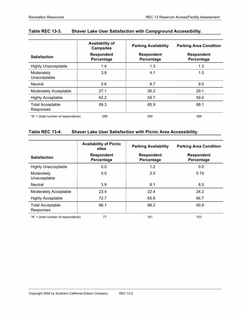
Table REC 13-3 summarizes the summer survey responses regarding user satisfactionwith these campground facilities. The survey results indicate that:
• 89.3% of respondents rated their satisfaction with campsite availability to beacceptable (27.1% moderately acceptable and 62.2% highly acceptable).

Recreation Resources REC 13 Reservoir Access/Facility Assessment
Copyright 2004 by Southern California Edison Company REC 13-5
• 85.9% of respondents rated parking availability for camping as acceptable (26.2%acceptable and 59.7% and highly acceptable).
• 88.1% of respondents rated parking area conditions as acceptable (29.1%moderately acceptable and 59.0% as highly acceptable).
Picnic Areas
Seven areas around the lake have been developed for picnicking and day use activitiesincluding Camp Edison Day Use Area, Dorabelle Picnic Area, Shaver Point Day UseArea, Road 1 Day Use Area, Road 2 Day Use Area, Eagle Point (Boat Only) Day UseArea, and Dinky Creek Road Rest Area.
Table REC 13-4 summarizes the summer survey results regarding satisfaction withthese picnic area facilities. The survey results indicate that:
• 96.1% of respondents rated their satisfaction with picnic site availability to beacceptable (23.4% moderately acceptable and 72.7% highly acceptable).
• 88.2% of respondents indicated picnic site parking availability was acceptable(22.4% moderately acceptable and 65.8% highly acceptable).
• 90.9% of respondents rated parking area conditions as acceptable (24.2%moderately acceptable and 66.7% highly acceptable).
Parking Areas
Designated parking is located at six areas around the lake including Camp Edison DayUse Area, Dorabelle Picnic Area, Shaver Point Day Use Area, Road 1 Day Use Area,Road 2 Day Use Area, and Dinky Creek Road Rest Area.
Trails
There are no formal trailheads at the lake which provide access to established trailsaround Shaver Lake. However, there are numerous informal access trails leading toand providing access along the north and west shore of Shaver Lake that originate fromday use/picnic areas, campgrounds, boat launches, and marinas. In addition, withinCamp Edison there several miles of informal yet developed trails for campers and dayusers. These trails are also maintained and used for nordic skiing during the winter.
5.1.2 HUNTINGTON LAKE
Huntington Lake can be accessed by roads, boat launches including docks andmarinas, parking areas, trails, campgrounds, and picnic areas. Huntington Lakerecreation facilities are summarized in Table REC 13-5, displayed in Figure REC 13-2and discussed below.

Recreation Resources REC 13 Reservoir Access/Facility Assessment
Copyright 2004 by Southern California Edison Company REC 13-6
Roads
Huntington Lake is accessed from Highway 168 along the eastern shoreline.Huntington Lake Road intersects with Highway 168 and provides lake access along thenorth and west shores. Access points off of Huntington Lake Road include CollegeCampground, Rancheria Marina, USDA-FS Huntington Lake Boat Ramp, Deer CreekPicnic Area, Deer Creek Campground, Kinnikinnick Camp Ground, Catavee CampGround, Bear Cove Picnic Area, Billy Creek Picnic Area, Upper and Lower Billy CreekCampground, Huntington Lake Resort, Dowville Picnic Area, and the Dam 3 ParkingArea. There are controlled access roadways along the southern shore of HuntingtonLake branching off from Huntington Lake Road. The entire shoreline, including the damstructures, is open to non-motorized public access.
Boat Launches (including docks and marinas)
Huntington Lake has two boat launch areas. The Huntington Lake Resort Boat Ramp ison the west end of the lake and has boat docks. On the east end of the lake is theUSDA-FS boat ramp. Additionally, the Rancheria Marina, which has boat docks, isclose to the USDA-FS boat launch.
Table REC 13-6 summarizes the summer survey responses regarding user satisfactionwith these boat launch facilities. The survey results indicate that:
• 92.1% of respondents rated their satisfaction with boat ramp availability to beacceptable (25.9% moderately acceptable and 66.2% highly acceptable).
• 82.9% indicated boat ramp parking availability to be acceptable (29.5% moderatelyacceptable and 53.4% highly acceptable).
• 85.7% of respondents indicated their satisfaction with boat ramp parking areaconditions to be acceptable (29.6% moderately acceptable and 56.1% highlyacceptable).
Campgrounds
There are seven campgrounds at Huntington Lake. The public campgrounds arelocated on the west and east ends of the lake. Upper and Lower Billy CreekCampgrounds are located on the west end of the lake and Deer Creek, Kinnikinnick,Catavee, College, and Rancheria campgrounds are located on the east end of the lake.The public campgrounds are operated by the USDA-FS through their concessionaire,CLM. There are four private Scout camps on the south shore of the lake: Camp Kern;Camp Olijato; Camp Mirimichi and Camp Gold Arrow and one Scout Camp on the northshore: Camp Silver Fir. Users of the private camps were not surveyed as part of theactive survey.
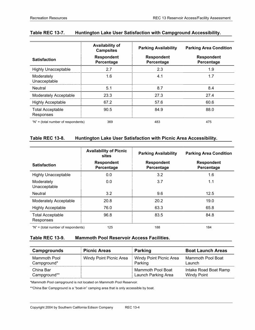
Table REC 13-7 summarizes the summer survey responses regarding user satisfactionwith campground facilities. The survey results indicate that:
Recreation Resources REC 13 Reservoir Access/Facility Assessment
Copyright 2004 by Southern California Edison Company REC 13-7
• 90.5% of respondents rated their satisfaction with campsite availability to beacceptable (23.3% moderately acceptable and 67.2% highly acceptable).
• 84.9% of respondents rated parking availability for camping as acceptable (27.3%moderately acceptable and 57.6% highly acceptable).
• 88.0% of respondents rated parking area conditions as acceptable (27.4%moderately acceptable and 60.6% highly acceptable).
Picnic Areas
Five areas around the lake have been developed for picnicking and day use activitiesincluding Bear Cove, Billy Creek, Deer Creek, Dowville, and the USDA-FS Beach andDay Use Area.
Table REC 13-8 summarizes the summer survey responses regarding user satisfactionwith picnic area facilities. The survey results indicate that:
• 96.8% of respondents rated their satisfaction with picnic site availability to beacceptable (20.8% moderately acceptable and 76.0% highly acceptable).
• 83.5% of respondents indicated picnic site parking availability was acceptable(20.2% moderately acceptable and 63.3% highly acceptable).
• 84.8% of respondents rated parking area conditions as acceptable (19.0%moderately acceptable and 65.8% highly acceptable).
Parking Areas
Designated parking is located at seven areas around the lake including Bear CovePicnic Area, Billy Creek Picnic Area, Deer Creek Picnic Area, Dowville Picnic Area, theUSDA-FS beach and day use area, Eastwood Visitor Center, and at Dam 3 alongHuntington Lake Road.
Summer survey respondents indicated their satisfaction with parking availability atpicnic areas and boat launches to be acceptable.
However, consultation with stakeholders indicates that parking near Dam 3 alongHuntington Lake Road is inadequate. Dam 3 located at the west end of HuntingtonLake and is a popular location for angling from the dam and hiking along the shore.Vehicle parking at this location consists of a small turn out and additional parking isalong the shoulder of Huntington Lake Road. Consultation with stakeholders hasindicated that parking at this location presents a potential safety hazard on busysummer days and on weekends when there is high recreation demand.

Recreation Resources REC 13 Reservoir Access/Facility Assessment
Copyright 2004 by Southern California Edison Company REC 13-8
Trails
Trail access to the lake is provided by numerous informal access trails located at boatlaunches, campgrounds and picnics areas. However, there is an established trail, theHuntington Shore Trail, which is approximately two miles in length and is located alongthe northern shoreline of Huntington Lake connecting the Billy Creek Picnic Area to theBear Cove Picnic Area.
5.1.3 MAMMOTH POOL RESERVOIR
Access to Mammoth Pool Reservoir is through a single primary area serviced by theMammoth Pool Road, which is off Minarets Road. Mammoth Pool reservoir recreationfacilities are summarized in Table REC 13-9 and displayed in Figure REC 13-3.
Roads
Mammoth Pool Reservoir is accessed from Mammoth Pool Road along the southwestcorner of the reservoir from the Mammoth Boat Launch to the Mammoth Pool Dam.Access points to the reservoir along the road include the Mammoth Boat Launch, WindyPoint Boat Launch, and the Windy Point Picnic Area. The reservoir is closed to publicvehicular access from May 1st to June 15th to avoid interference with the annual deermigration. When open, vehicular access to the lake is available where indicated above.The entire shoreline, including the dam structures, is open to non-motorized publicaccess.
Boat Launches (including docks and marinas)
The main boat launch area is the Mammoth Pool boat launch. The ramp has beendesigned to accommodate a wide variance in water surface elevation. When watersurface elevations fall below the functional range of the Mammoth Pool Boat Ramp, thesmaller, undeveloped, Windy Point Boat Launch can be used.
Table REC 13-10 summarizes the summer survey responses regarding usersatisfaction with boat launch facilities. The survey results indicate that:
• 92.1% of respondents rated their satisfaction with boat ramp availability to beacceptable (34.2% moderately acceptable and 57.9% highly acceptable).
• 68.4% indicated boat ramp parking availability to be acceptable (31.6% moderatelyacceptable and 36.8% highly acceptable).
• 74.3% of respondents indicated their satisfaction with boat ramp parking areaconditions to be acceptable (31.4% moderately acceptable and 42.9% highlyacceptable).
Recreation Resources REC 13 Reservoir Access/Facility Assessment
Copyright 2004 by Southern California Edison Company REC 13-9
Campgrounds
The Mammoth Pool Campground is located a short distance from the reservoir and boatlaunch area and is operated by the USDA-FS/CLM. The China Bar Boat Camp is onlyaccessible by boat and is located along the northwest shore of the reservoir.
Table REC 13-11 summarizes the summer survey results regarding satisfaction withcampground facilities. The survey results indicate that:
• 92.7% of respondents rated their satisfaction with campsite availability to beacceptable (22.0% moderately acceptable and 70.7% highly acceptable).
• 75.3% of respondents rated parking availability for camping as acceptable (20.5%moderately acceptable and 54.8% highly acceptable).
• 83.3% of respondents rated parking area conditions as acceptable (22.7%moderately acceptable and 60.6% highly acceptable).
Picnic Areas
The Windy Point Picnic Area has been developed for picnicking and day use activities.This area is a short distance from the boat launch on the west end of the reservoir.There is undeveloped parking at the picnic area.
Table REC 13-12 summarizes the summer survey responses regarding usersatisfaction with picnic facilities. The survey results indicate that:
• 100% of respondents rated their satisfaction with picnic site availability to be “highlyacceptable.”
• 100% of respondents indicated picnic site parking availability was acceptable (10.5%moderately acceptable and 89.5% highly acceptable).
• 100% of respondents indicated parking area conditions was acceptable (10.5%moderately acceptable and 89.5% highly acceptable).
Parking Areas
There is undeveloped parking at the Windy Point Picnic Area. This area is a shortdistance from the Windy Point boat launch on the west end of the reservoir.
Trails
The Mammoth Pool Campground Area has an informal trail providing access to thereservoir. The French Trail is an established trail which runs along the southwestborder of the reservoir.
Recreation Resources REC 13 Reservoir Access/Facility Assessment
Copyright 2004 by Southern California Edison Company REC 13-10
5.1.4 FLORENCE LAKE
Access to Florence Lake is through a single primary area serviced by a single road.Access to the lake is from the picnic area or boat launch. Florence Lake recreationfacilities are summarized in Table REC 13-13 and displayed in Figure REC 13-4.
Roads
Florence Lake is accessed from Florence Lake Road, which intersects Kaiser PassRoad east of Kaiser Pass. The USDA-FS closes the Kaiser Pass Road to vehiculartraffic during the winter as snow removal activities are not performed. The unplowedroad is used in winter as a snowmobile trail and trail riders can snowmobile to FlorenceLake. The road ends at the Florence Lake Picnic Area. The reservoir access pointsinclude the Florence Lake Boat Ramp and the Florence Lake Picnic Area. The USDA-FS recognizes the Florence Lake Trail, which runs along the east shore of FlorenceLake. With the exception of dam structures and other project related facilities, the entireshoreline is open to non-motorized public access.
Boat Launches (including docks and marinas)
There is a single boat launch area at Florence Lake. It is located at the end of theaccess road to the lake. There is developed parking at the boat launch site. The boatramp at the lake is paved at its upper end and the ramp surface changes to gravel ordecomposed granite as it extends into the lake. Due to the wide variance in the watersurface elevations at Florence Lake, the ramp essentially extends to the bottom of thelake. A ferry service is operated at the lake and provides transport across the lake tohikers and backpackers leading to the wilderness areas and the Pacific Crest Trail eastof the lake. The Ferry is also used to transport people and supplies that are traveling toa private ranch located several miles upstream along the South Fork San Joaquin River.
Table REC 13-14 summarizes the summer survey results regarding satisfaction withboat launch facilities. The survey results indicate that:
• 93% of respondents rated their satisfaction with boat ramp availability to beacceptable (32.4% moderately acceptable and 60.6% highly acceptable).
• 80.9% indicated boat ramp parking availability to be acceptable (33.3% moderatelyacceptable and 47.6% highly acceptable).
• 87.2% of respondents indicated their satisfaction with boat ramp parking areaconditions to be acceptable (39.5% moderately acceptable and 47.7% highlyacceptable).
Campgrounds
There are no campgrounds on Florence Lake. Camping at Florence Lake is provided atthe Jackass Meadows Campground that is operated by the USDA-FS/CLM. The

Recreation Resources REC 13 Reservoir Access/Facility Assessment
Copyright 2004 by Southern California Edison Company REC 13-11
campground is located just downstream of the base of the dam and is a short distancefrom the boat launch and day use areas on the lake.
Table REC 13-15 summarizes the summer survey results regarding satisfaction with thecampground facility. The survey results indicate that:
• 92.3% of respondents rated their satisfaction with campsite availability to beacceptable (12.3% moderately acceptable and 80.0% highly acceptable).
• 88% of respondents rated parking availability for camping as acceptable (21.0%moderately acceptable and 67.0% highly acceptable).
• 87.6% of respondents rated parking area conditions as acceptable (24.3%moderately acceptable and 63.3% highly acceptable).
Picnic Areas
The Florence Lake Day Use/Picnic Area is on the lake adjacent to the boat launch area.
Table REC 13-16 summarizes the summer survey results regarding satisfaction with thepicnic facility. The survey results indicate that:
• 100% of respondents rated their satisfaction with the picnic site availability to beacceptable (15.2% moderately acceptable and 84.8% highly acceptable).
• 90.7% of respondents indicated picnic site parking availability was acceptable(14.1% moderately acceptable and 76.6% highly acceptable).
• 93.6% of respondents rated parking area conditions as acceptable (19.0%moderately acceptable and 74.6% highly acceptable).
Parking Areas
There is designated parking at the Florence Lake Day Use/Picnic Area, next to the boatlaunch area.
Trails
The Florence Lake Trail crosses the inlet of the South Fork San Joaquin River beforeheading east towards the Pacific Crest Trail. Moderate Diversion Pools – AccessFacilities.
The moderate size diversion pools/forebays (Mono, Bear, Balsam Meadows, and Dams4, 5 and 6 along Big Creek) have either limited or no development. Mono DiversionPool/Forebay is the most developed with a campground/picnic area providing access tothe diversion pond. Bear Diversion Pool is accessed by a 4-wheel drive route or by footfrom the Pacific Crest Trail, and Balsam Forebay has a picnic area that is accessed bya hiking along a road that is closed to public vehicles. The Dam 4 and Dam 5 Diversion

Recreation Resources REC 13 Reservoir Access/Facility Assessment
Copyright 2004 by Southern California Edison Company REC 13-12
Pools/Forebays do not have developed recreation facilities and are located along roadsthat are not open to public vehicular travel. However, the public may access thesediversion pools/forebays by foot or bike. Dam 6 Diversion Pool/Forebay does have twostairways that provide angler access to the water.
Access facilities at each of the moderate size diversion pools/forebays are discussed inthe following sections.
5.1.5 BALSAM FOREBAY
A developed picnic area provides shoreline access to Balsam Meadow Forebay (FigureREC 13-1). Access to the picnic area is from a developed parking area, which alsofunctions as a Sno-Park in winter, located along Highway 168. Visitors choosing torecreate at the picnic area must hike from the parking area along an established trail, ora road which is closed to public vehicular travel. There are restrooms, but no boatlaunches, or campgrounds at Balsam Forebay. Balsam Forebay recreation facilities aresummarized in Table REC 13-17.
Picnic Areas
The Balsam Forebay Day Use/Picnic Area located adjacent to forebay. Table REC 13-18 summarizes the summer survey results regarding satisfaction with the picnic area.The survey results indicate that:
• 100% of respondents rated their satisfaction with the picnic site availability to beacceptable (40.0% moderately acceptable and 60.0% highly acceptable).
• 100% of respondents indicated picnic site parking availability was acceptable (33.3%moderately acceptable and 66.7% highly acceptable).
• 100% of respondents rated parking area conditions as acceptable (66.7%moderately acceptable and 33.3% highly acceptable).
5.1.6 BEAR DIVERSION POOL/FOREBAY
Access to the Bear Diversion and Forebay is by driving along the Bear OHV Route6S83, which originates from Kaiser Pass Road (Figure REC 13-5). The Bear CreekTrailhead originates at an undeveloped parking area adjacent to the forebay. Aninformal trail around the forebay provides access to anglers and connects on the otherend to the Pacific Crest hiking trail. There are no developed boat launches, picnicareas, or campgrounds at the forebay.
5.1.7 MONO DIVERSION AND FOREBAY
The Mono Diversion and Forebay is located off of Kaiser Pass Road and access to theforebay shore is provided from the developed Mono Creek Campground/Picnic Area(Figure REC 13-5). Informal trails along the forebay provide access to the water’s edge.

Recreation Resources REC 13 Reservoir Access/Facility Assessment
Copyright 2004 by Southern California Edison Company REC 13-13
There are no developed boat launches at the forebay. Mono Diversion and Forebayrecreation facilities are summarized in Table REC 13-19.
Campgrounds
The Mono Campground is located adjacent to the Mono Forebay and is operated by theUSDA-FS/CLM. Table REC 13-20 summarizes the summer survey results regardingsatisfaction with the campground facility. The survey results indicate that:
• 92.5% of respondents rated their satisfaction with campsite availability to beacceptable (27.5% moderately acceptable and 65.0% highly acceptable).
• 86.8% of respondents rated parking availability for camping as acceptable (23.7%moderately acceptable and 63.1% highly acceptable).
• 94.6% of respondents rated parking area conditions as acceptable (21.6%moderately acceptable and 73.0% highly acceptable).
Picnic Areas
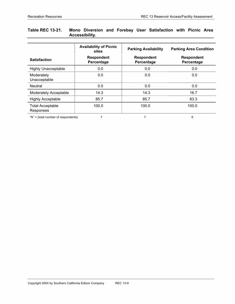
The Mono Forebay Day Use/Picnic Area is located adjacent to the campground areaand the forebay. Table REC 13-21 summarizes the summer survey results regardingsatisfaction with the picnic facility. The survey results indicate that:
• 100% of respondents rated their satisfaction with the picnic site availability to beacceptable (14.3% moderately acceptable and 85.7% highly acceptable).
• 100.0% of respondents indicated picnic site parking availability was acceptable(14.3% moderately acceptable and 85.7% highly acceptable).
• 100.0% of respondents rated parking area conditions as acceptable (16.7%moderately acceptable and 83.3% highly acceptable).
5.1.8 DAM 4 DIVERSION AND FOREBAY
Dam 4 Diversion and Forebay is located along Big Creek near Powerhouse 1. Accessto this location is by way of Cascada Road which is a controlled access road to thepowerhouse (Figure REC 13-2). However, there are no developed recreation facilitiesat the forebay and shoreline vehicular access is limited due to the steep topography,and SCE’s need for controlled access to the powerhouse, switchyard, and damstructure.
5.1.9 DAM 5 DIVERSION AND FOREBAY
Dam 5 Diversion and Forebay is located along Big Creek near Powerhouse 2 andaccess to this location is by way of the Upper Canyon Road, which is a controlledaccess road that is closed to public vehicular travel (Figure REC 13-6). The public mayaccess the forebay by hiking or bicycling along the Upper Canyon Road. However,

Recreation Resources REC 13 Reservoir Access/Facility Assessment
Copyright 2004 by Southern California Edison Company REC 13-14
there are no developed recreation facilities at the forebay and shoreline access islimited, due to the steep topography, lack of available parking, safety concerns for thepublic on the Upper Canyon Road, and SCE’s need for security and controlled accessto its powerhouse, switchyard and dam structures.
5.1.10 DAM 6 DIVERSION AND FOREBAY
Dam 6 Diversion and Forebay is located on the San Joaquin River near Powerhouse 8and access to this location is by way of either the Upper or Lower Canyon Road (FigureREC 13-6), both are controlled access roads that are closed to public vehicular travel.The upstream end of the forebay can be accessed by USDA-FS Road 8S03 which islocated off of Minarets Road. The public may travel along road 8S03 to the SanJoaquin River where further public vehicular access is restricted by a locked gate. Anunimproved parking area is located near the gate. The public may hike or bicycle alongthis road beyond the gate to access the forebay.
Access to the forebay shoreline is provided by two angler access stairways which leadfrom the road to the water’s edge. A metal stairway provides access to the north shoreof the forebay and is located at the upstream end of the forebay adjacent to the road8S03 bridge crossing over the San Joaquin River. A wooden stairway provides accessto the east shore of the forebay and is located along the non-public vehicular accessportion of Road 8S03 approximately half the distance between the bridge crossing andBig Creek Powerhouse No. 8.
Recreation Resources REC-13 Reservoir Access/Facility Assessment
Copyright 2004 by Southern California Edison Company REC 13-15
6.0 LITERATURE CITED
Southern California Edison. 2001. Final Technical Study Plan Package for the BigCreek Hydroelectric System Alternative Licensing Process. August 2001.
Southern California Edison. 2003. 2002 Technical Study Report Package for the BigCreek Hydroelectric System Alternative Licensing Process. Recreation Reports.October 2003.

Recreation Resources REC-13 Reservoir Access/Facility Assessment
Copyright 2004 by Southern California Edison Company
TABLES

Recreation Resources REC 13 Reservoir Access/Facility Assessment
Copyright 2004 by Southern California Edison Company REC 13-1
Table REC 13-1. Shaver Lake Access Facilities.
Campgrounds Picnic Areas Parking Boat Launch Areas
Camp EdisonCampground
Camp Edison Day UseArea
Camp Edison Day UseArea Parking
Camp Edison BoatLaunch
Dorabelle Campground Dorabelle Picnic Area Dorabelle Picnic AreaParking
County Boat Launch atSierra Marina
Shaver Point Day UseArea
Shaver Point Day UseArea Parking
Road 1 Day Use Area Road 1 Day Use AreaParking
Road 2 Day Use Area Road 2 Day Use AreaParking
Eagle Point Boat OnlyDay Use AreaDinky Creek Road RestArea
Dinky Creek Road RestArea Parking
Table REC 13-2. Shaver Lake User Satisfaction with Boating Access Facilities.
Availability of BoatRamps Parking Availability Parking Area Condition
Satisfaction RespondentPercentage
RespondentPercentage
RespondentPercentage
Highly Unacceptable 1.2 3.0 0.4Moderately Unacceptable 3.6 7.6 3.8Neutral 5.2 11.7 12.5
Moderately Acceptable 29.0 31.8 31.7Highly Acceptable 61.1 45.8 51.7
Total Acceptable Responses 90.1 77.6 83.4
“N” = (total number of respondents) 252 264 265
Recreation Resources REC 13 Reservoir Access/Facility Assessment
Copyright 2004 by Southern California Edison Company REC 13-2
Table REC 13-3. Shaver Lake User Satisfaction with Campground Accessibility.
Availability ofCampsites Parking Availability Parking Area Condition
Satisfaction RespondentPercentage
RespondentPercentage
RespondentPercentage
Highly Unacceptable 1.4 1.3 1.3ModeratelyUnacceptable
3.8 4.1 1.5
Neutral 5.6 8.7 9.0
Moderately Acceptable 27.1 26.2 29.1Highly Acceptable 62.2 59.7 59.0
Total AcceptableResponses
89.3 85.9 88.1
“N” = (total number of respondents) 288 390 388
Table REC 13-4. Shaver Lake User Satisfaction with Picnic Area Accessibility.
Availability of Picnicsites Parking Availability Parking Area Condition
Satisfaction RespondentPercentage
RespondentPercentage
RespondentPercentage
Highly Unacceptable 0.0 1.2 0.0ModeratelyUnacceptable
0.0 2.5 0.74
Neutral 3.9 8.1 8.5
Moderately Acceptable 23.4 22.4 24.2Highly Acceptable 72.7 65.8 66.7
Total AcceptableResponses
96.1 88.2 90.9
“N” = (total number of respondents) 77 161 153

Recreation Resources REC 13 Reservoir Access/Facility Assessment
Copyright 2004 by Southern California Edison Company REC 13-3
Table REC 13-5. Huntington Lake Access Facilities.
Campgrounds Picnic Areas Parking Boat Launch AreasUpper and Lower BillyCreek Campground
Bear Cove Picnic Area Bear Cove Picnic AreaParking
Huntington Lake ResortBoat Ramp
Deer CreekCampground
Billy Creek Picnic Area Billy Creek Picnic AreaParking
USFS Boat Ramp
College Campground Deer Creek Picnic Area Deer Creek Picnic AreaParking
Dowville Picnic Area Dowville Picnic AreaParking
Rancheria Campground USFS Beach/Day Use USFS Boat RampParking Area
KinnikinnickCampground
Huntington Lake ResortParking
Catavee Campground Eastwood Visitor CenterParkingDam 3 Parking Area
Table REC 13-6. Huntington Lake User Satisfaction with Boating Access Facilities.
Availability of BoatRamps Parking Availability Parking Area Condition
Satisfaction RespondentPercentage
RespondentPercentage
RespondentPercentage
Highly Unacceptable 0.6 2.0 0.3ModeratelyUnacceptable
2.4 4.3 2.8
Neutral 4.9 10.8 11.2
Moderately Acceptable 25.9 29.5 29.6Highly Acceptable 66.2 53.4 56.1
Total AcceptableResponses
92.1 82.9 85.7
“N” = (total number of respondents) 328 352 358
Recreation Resources REC 13 Reservoir Access/Facility Assessment
Copyright 2004 by Southern California Edison Company REC 13-4
Table REC 13-7. Huntington Lake User Satisfaction with Campground Accessibility.
Availability ofCampsites Parking Availability Parking Area Condition
Satisfaction RespondentPercentage
RespondentPercentage
RespondentPercentage
Highly Unacceptable 2.7 2.3 1.9ModeratelyUnacceptable
1.6 4.1 1.7
Neutral 5.1 8.7 8.4
Moderately Acceptable 23.3 27.3 27.4Highly Acceptable 67.2 57.6 60.6
Total AcceptableResponses
90.5 84.9 88.0
“N” = (total number of respondents) 369 483 475
Table REC 13-8. Huntington Lake User Satisfaction with Picnic Area Accessibility.
Availability of Picnicsites Parking Availability Parking Area Condition
Satisfaction RespondentPercentage
RespondentPercentage
RespondentPercentage
Highly Unacceptable 0.0 3.2 1.6ModeratelyUnacceptable
0.0 3.7 1.1
Neutral 3.2 9.6 12.5
Moderately Acceptable 20.8 20.2 19.0Highly Acceptable 76.0 63.3 65.8
Total AcceptableResponses
96.8 83.5 84.8
“N” = (total number of respondents) 125 188 184
Table REC 13-9. Mammoth Pool Reservoir Access Facilities.
Campgrounds Picnic Areas Parking Boat Launch AreasMammoth PoolCampground*
Windy Point Picnic Area Windy Point Picnic AreaParking
Mammoth Pool BoatLaunch
China BarCampground**
Mammoth Pool BoatLaunch Parking Area
Intake Road Boat RampWindy Point
*Mammoth Pool campground is not located on Mammoth Pool Reservoir.
**China Bar Campground is a “boat-in” camping area that is only accessible by boat.

Recreation Resources REC 13 Reservoir Access/Facility Assessment
Copyright 2004 by Southern California Edison Company REC 13-5
Table REC 13-10. Mammoth Pool Reservoir User Satisfaction with Boating AccessFacilities.
Availability of BoatRamps Parking Availability Parking Area Condition
Satisfaction RespondentPercentage
RespondentPercentage
RespondentPercentage
Highly Unacceptable 0.0 15.8 5.7ModeratelyUnacceptable
7.9 7.9 8.6
Neutral 0.0 7.9 11.4
Moderately Acceptable 34.2 31.6 31.4Highly Acceptable 57.9 36.8 42.9
Total AcceptableResponses
92.1 68.4 74.3
“N” = (total number of respondents) 38 38 35
Table REC 13-11. Mammoth Pool Reservoir User Satisfaction with CampgroundAccessibility.
Availability ofCampsites Parking Availability Parking Area Condition
Satisfaction RespondentPercentage
RespondentPercentage
RespondentPercentage
Highly Unacceptable 0.0 8.2 1.5
ModeratelyUnacceptable
4.9 8.2 9.1
Neutral 2.4 8.2 6.1
Moderately Acceptable 22.0 20.5 22.7
Highly Acceptable 70.7 54.8 60.6
Total AcceptableResponses
92.7 75.3 83.3
“N” = (total number of respondents) 41 73 66

Recreation Resources REC 13 Reservoir Access/Facility Assessment
Copyright 2004 by Southern California Edison Company REC 13-6
Table REC 13-12. Mammoth Pool Reservoir User Satisfaction with Picnic AreaAccessibility.
Availability of Picnicsites Parking Availability Parking Area Condition
Satisfaction RespondentPercentage
RespondentPercentage
RespondentPercentage
Highly Unacceptable 0.0 0.0 0.0ModeratelyUnacceptable
0.0 0.0 0.0
Neutral 0.0 0.0 0.0
Moderately Acceptable 0.0 10.5 10.5Highly Acceptable 100.0 89.5 89.5
Total AcceptableResponses
100.0 100.0 100.0
“N” = (total number of respondents) 10 19 19
Table REC 13-13. Florence Lake Access Facilities.
Campgrounds Picnic Areas Parking Boat Launch Areas
Jackass MeadowsCampground
Florence Lake PicnicArea
Florence Lake PicnicArea Parking
Florence Lake BoatRamp
Table REC 13-14. Florence Lake User Satisfaction with Boating Access Facilities.
Availability of BoatRamps Parking Availability Parking Area Condition
Satisfaction RespondentPercentage
RespondentPercentage
RespondentPercentage
Highly Unacceptable 1.4 3.6 0.0ModeratelyUnacceptable
4.2 4.8 3.5
Neutral 1.4 10.7 9.3
Moderately Acceptable 32.4 33.3 39.5Highly Acceptable 60.6 47.6 47.7
Total AcceptableResponses
93.0 80.9 87.2
“N” = (total number of respondents) 71 84 86

Recreation Resources REC 13 Reservoir Access/Facility Assessment
Copyright 2004 by Southern California Edison Company REC 13-7
Table REC 13-15. Florence Lake User Satisfaction with Campground Accessibility.
Availability ofCampsites Parking Availability Parking Area Condition
Satisfaction RespondentPercentage
RespondentPercentage
RespondentPercentage
Highly Unacceptable 3.1 0.0 1.1ModeratelyUnacceptable
1.5 1.7 2.8
Neutral 3.1 10.2 8.5
Moderately Acceptable 12.3 21.0 24.3Highly Acceptable 80.0 67.0 63.3
Total AcceptableResponses
92.3 88.0 87.6
“N” = (total number of respondents) 65 176 177
Table REC 13-16. Florence Lake User Satisfaction with Picnic Area Accessibility.
Availability of Picnicsites Parking Availability Parking Area Condition
Satisfaction RespondentPercentage
RespondentPercentage
RespondentPercentage
Highly Unacceptable 0.0 0.0 0.0ModeratelyUnacceptable
0.0 3.1 0.0
Neutral 0.0 6.3 6.3
Moderately Acceptable 15.2 14.1 19.0Highly Acceptable 84.8 76.6 74.6
Total AcceptableResponses
100.0 90.7 93.6
“N” = (total number of respondents) 33 64 63
Table REC 13-17. Balsam Forebay Access Facilities.
Campgrounds Picnic Areas Parking Boat Launch Areas
None Balsam Forebay Balsam Sno-ParkParking Area
None

Recreation Resources REC 13 Reservoir Access/Facility Assessment
Copyright 2004 by Southern California Edison Company REC 13-8
Table REC 13-18. Balsam Forebay User Satisfaction with Picnic Area Accessibility.
Availability of Picnicsites Parking Availability Parking Area Condition
Satisfaction RespondentPercentage
RespondentPercentage
RespondentPercentage
Highly Unacceptable 0.0 0.0 0.0ModeratelyUnacceptable
0.0 0.0 0.0
Neutral 0.0 0.0 0.0
Moderately Acceptable 40.0 33.3 66.7Highly Acceptable 60.0 66.7 33.3
Total AcceptableResponses
100.0 100.0 100.0
“N” = (total number of respondents) 5 3 3
Table REC 13-19. Mono Diversion and Forebay Access Facilities.
Campgrounds Picnic Areas Parking Boat Launch Areas
Mono CreekCampground
Mono Creek Picnic Area Mono Creek ParkingArea
None
Table REC 13-20. Mono Diversion and Forebay User Satisfaction with CampgroundAccessibility.
Availability ofCampsites Parking Availability Parking Area Condition
Satisfaction RespondentPercentage
RespondentPercentage
RespondentPercentage
Highly Unacceptable 2.5 0.0 0.0ModeratelyUnacceptable
2.5 5.3 5.4
Neutral 2.5 7.9 0.0
Moderately Acceptable 27.5 23.7 21.6Highly Acceptable 65.0 63.1 73.0
Total AcceptableResponses
92.5 86.8 94.6
“N” = (total number of respondents) 40 38 37
Recreation Resources REC 13 Reservoir Access/Facility Assessment
Copyright 2004 by Southern California Edison Company REC 13-9
Table REC 13-21. Mono Diversion and Forebay User Satisfaction with Picnic AreaAccessibility.
Availability of Picnicsites Parking Availability Parking Area Condition
Satisfaction RespondentPercentage
RespondentPercentage
RespondentPercentage
Highly Unacceptable 0.0 0.0 0.0ModeratelyUnacceptable
0.0 0.0 0.0
Neutral 0.0 0.0 0.0
Moderately Acceptable 14.3 14.3 16.7Highly Acceptable 85.7 85.7 83.3
Total AcceptableResponses
100.0 100.0 100.0
“N” = (total number of respondents) 7 7 6

Recreation Resources REC-13 Reservoir Access/Facility Assessment
Copyright 2004 by Southern California Edison Company
FIGURES
Recreation Resources REC-13 Reservoir Access/Facility Assessment
Copyright 2004 by Southern California Edison Company
Placeholder for Figures
Non-Internet Public Information
These Figures have been removed in accordance with the Commission regulationsat 18 CFR Section 388.112.
These Figures are considered Non-Internet Public information and should not beposted on the Internet. This information is provided in Volume 4 of the Applicationfor New License and is identified as “Non-Internet Public” information. Thisinformation may be accessed from the FERC’s Public Reference Room, but is notexpected to be posted on the Commission’s electronic library, except as anindexed item.