
Readme.trmm g2b31
14
RG2B31 README Data Access for RG2B31, the Geographical Subsets of the Combined TRMM Microwave Imager (TMI) and Precipitation Radar (PR) Gridded Orbital Data Set RG2B31: ftp://disc2.nascom.nasa.gov/data/s4pa/TRMM_L2/TRMM_G2B31/ Contents of the Geographical Subsets of the Combined TRMM Microwave Imager (TMI) and Precipitation Radar (PR) Gridded Orbital Data Set Readme Summary Sponsor Future Updates Data Set Description • Data Characteristics • Data Format Sample Software • Fortran Sample • C Sample • IDL Sample References Data Access • Anonymous FTP Points of Contact Summary This document provides a general description of the Geographical Subsets of the Combined TRMM Microwave Imager (TMI) and Precipitation Radar (PR) gridded orbital rainfall data, a
-
Upload
sikandar-ali -
Category
Documents
-
view
30 -
download
0
Transcript of Readme.trmm g2b31

RG2B31 README
Data Access for RG2B31, the Geographical Subsets of the Combined TRMM Microwave Imager (TMI) and Precipitation Radar (PR)
Gridded Orbital Data Set
RG2B31: ftp://disc2.nascom.nasa.gov/data/s4pa/TRMM_L2/TRMM_G2B31/
Contents of the Geographical Subsets of the Combined TRMM Microwave Imager (TMI) and Precipitation Radar (PR) Gridded Orbital Data Set Readme
Summary Sponsor Future Updates Data Set Description
• Data Characteristics • Data Format
Sample Software
• Fortran Sample • C Sample • IDL Sample
References Data Access
• Anonymous FTP
Points of Contact
Summary
This document provides a general description of the Geographical Subsets of the Combined TRMM Microwave Imager (TMI) and Precipitation Radar (PR) gridded orbital rainfall data, a

special product derived from the TRMM standard product (2B-31) TMI and PR combined and mapped to a 0.1 degree x 0.1 degree latitude/longitude grid. The spatial coverage is of a particular geographical region, the bounding latitudes and longitudes of which are defined in the file header record. The parameters included in this data set include the mean, standard deviation, and number of samples of the surface rain rate. The document also provides the information necessary to readily access and interpret the parameters stored in the files.
This product is produced by the Hydrology Data Support Team of the Goddard Earth Sciences Data and Information Services Center with inputs from members of the TRMM Science Team. Questions about reading and accessing these files should be directed to [email protected].
Sponsor
The distribution of this data set is being funded by NASA's Earth Science Enterprise. The data are not copyrighted; however, we request that when you publish data or results using these data, please acknowledge as follows:
The authors wish to thank the Distributed Active Archive Center (Code 610.2) at the Goddard Space Flight Center, Greenbelt, MD, 20771, for producing and distributing the data; and the TRMM Science Data and Information System at the Goddard Space Flight Center for providing the original data from which this product originates. Goddard's contribution to these activities was sponsored by NASA's Earth Science Enterprise.
Future Updates
The Goddard DAAC will update this data set as new data are processed and made available by the data producers, or as previous data are reprocessed and submitted to the DAAC for archival.
Data Set Description
Further information on the contents and structure of the TMI 2B-31 product can be found in Volume 4 of the "File Specifications for TSDIS Products - Level 2 and Level 3" (PDF document). The Combined TRMM Microwave Imager (TMI) and Precipitation Radar (PR) product contains vertical hydrometeor profiles, using data from the PR and the 10 GHz channels of the TMI.
There is one parameter in the gridded orbital data set:
• surface rain rate
This parameter is reported over both land and sea. The mean and standard deviation for a grid box are included as well as the number of rays. The mean surface rain rate of a grid box is the average over all rays.
The mean surface rain rate R and its standard deviation σ(R) within a given grid box is computed as follows:
R = SUM( Ri ) / NR
σ(R) = { SUM ( Ri - R)2 / NR }0. 5
In the above equations, Ri is the surface rain rate for ray i of the original orbital data, NR is the total number of rays for a grid box, and the sum is over all rays.
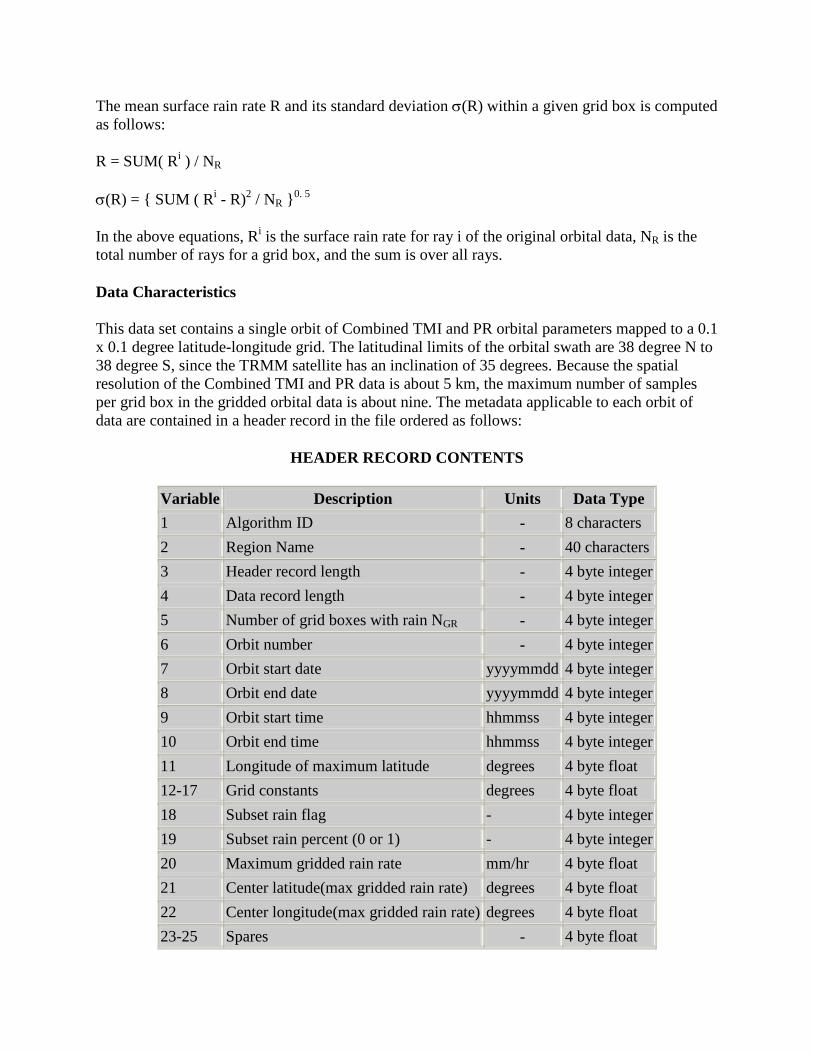
Data Characteristics
This data set contains a single orbit of Combined TMI and PR orbital parameters mapped to a 0.1 x 0.1 degree latitude-longitude grid. The latitudinal limits of the orbital swath are 38 degree N to 38 degree S, since the TRMM satellite has an inclination of 35 degrees. Because the spatial resolution of the Combined TMI and PR data is about 5 km, the maximum number of samples per grid box in the gridded orbital data is about nine. The metadata applicable to each orbit of data are contained in a header record in the file ordered as follows:
HEADER RECORD CONTENTS
Variable Description Units Data Type 1 Algorithm ID - 8 characters 2 Region Name - 40 characters 3 Header record length - 4 byte integer 4 Data record length - 4 byte integer 5 Number of grid boxes with rain NGR - 4 byte integer 6 Orbit number - 4 byte integer 7 Orbit start date yyyymmdd 4 byte integer 8 Orbit end date yyyymmdd 4 byte integer 9 Orbit start time hhmmss 4 byte integer 10 Orbit end time hhmmss 4 byte integer 11 Longitude of maximum latitude degrees 4 byte float 12-17 Grid constants degrees 4 byte float 18 Subset rain flag - 4 byte integer 19 Subset rain percent (0 or 1) - 4 byte integer 20 Maximum gridded rain rate mm/hr 4 byte float 21 Center latitude(max gridded rain rate) degrees 4 byte float 22 Center longitude(max gridded rain rate) degrees 4 byte float 23-25 Spares - 4 byte float

The grid constants (variables 12-17) include the starting latitude and longitude of the gridded output (-39.95 and -179.95 degrees, respectively), the ending latitude and longitude of the gridded output (39.95 and 179.95 degrees, respectively), as well as the latitudinal and longitudinal increments (0.1 and 0.1 degree, respectively). The spares (variables 24-25) pad the header out to the same record length as the data record length multiplied by seven.
The geolocation, time stamp, land sea index and parameter statistics for each grid box are contained in data records structured as follows:
DATA RECORD CONTENTS
Variable Description Units Data Type 1 Center latitude of grid box deg * 100 2 byte integer 2 Center longitude of grid box deg * 100 2 byte integer 3 Time stamp for grid box ddhhmmss 4 byte integer 4 Land sea index - 2 byte integer 5 Number of ray in box NR - 2 byte integer 6 Surface rain rate R mm/hr * 100 4 byte integer
7 Standard deviation of surface rain rate σ(R) mm/hr * 100 4 byte integer
The time stamp for a particular grid box is the time stamp of the last ray included in that box (in the original 2B-31 data file, a time stamp is assigned on a per-scan, rather than a per-ray, basis). The land sea index has values of 1 or 0, depending on whether the center of a grid box is over land or ocean, respectively. The parameter statistics are scaled by a factor of 100 to provide 2-decimal accuracy when stored as 16-bit or 32-bit integers. Thus, for proper interpretation of the data, these values must be descaled by 100 when reading the file.
Data Format
These data are stored as IEEE binary with record length of 20 bytes (five 4-byte words). The total number of data content records in each file is determined by the first variable in the header record (see Header Record table above):
Nrec = 7 + NGR
where:
record 1-7 : header record 8 : data record for first grid box : record NGR + 7 : data record for last grid box

The progression is such that the data for the southwesternmost grid box are reported first, and the data for the northeasternmost grid box are reported last. Thus, the central coordinates of the first box are (39.95 S, 179.95 W) and those of the last box are (39.95 N, 179.95 E), provided that at least one ray in the original 2B-31 orbital file falls within these boxes.
File sizes are very small and various with different geographical regions.
The file naming convention for the Combined TMI and PR Gridded Orbital data set conforms to the file naming convention for the standard TRMM data products, with slight modifications:
RG2B31.yyyymmdd.n.region.v.BIN
where:
RG = Regional Gridded 2B31 = TRMM algorithm ID for original orbital data product yyyy = 4 digit year mm = month number dd = day of month n = orbit number region = short name of the geographical region v = data product version number for 2B-31 product BIN = Binary
As an example, the file RG2B31.19971228.475.AL.5.BIN refers to the Alabama subset of the Gridded Orbital data product generated from the standard TRMM product, 2B31.971228.475.5.HDF, collected on December 28, 1997 for orbit number 475, and distributed as the fifth version of the product.
Sample Software
Sample programs in FORTRAN, C, and IDL for reading the Combined TMI and PR Regional Gridded RG2B31 data are included below. The programs were developed and tested on a Silicon Graphics machine running the IRIX operating system. You may have to make some minor modifications to the programs in order to run them correctly on different machines (e.g., record length keyword "recl" may need to be expressed in terms of bytes rather than 4-byte words in the FORTRAN program, depending on the machine). SAMPLE READ PROGRAM IN FORTRAN: ------------------------------- c ************************************************************************ c * c * Program Name: c * ------------ c * ReadRG2B31.f c * c * Description: c * -----------

c * This sample fortran program shows how to read RG2B31, Geo-reional c * gridded binary files. c * c * Date Author Name Change Description c * ----------- ------------ ----------------------------- c * 30-Aug-2001 Hualan Rui Modified based on ReadG2B31.f c * c *********************************************************************** character*120 file_in INTEGER*4 n, nmax c Structure for RG2B31 header record c ------------------------------------ STRUCTURE /RG2B31_HEADER/ character*8 algID character*40 region INTEGER*4 head_len INTEGER*4 rec_len INTEGER*4 totBoxes INTEGER*4 orbitNumber INTEGER*4 beginDate INTEGER*4 endDate INTEGER*4 beginTime INTEGER*4 endTime REAL*4 lonMaxLat REAL*4 lat0 REAL*4 lon0 REAL*4 late REAL*4 lone REAL*4 dlat REAL*4 dlon INTEGER*4 SubsetRainFlag INTEGER*4 SubsetRainPercent REAL*4 BoxRainMax REAL*4 BoxRainMaxLat REAL*4 BoxRainMaxLon REAL*4 spare(3) END STRUCTURE c Structure for RG2B31 data record c ------------------------------------------- STRUCTURE /RG2B31_STNREC/ INTEGER*2 lat INTEGER*2 lon INTEGER*4 dayntime INTEGER*2 landsea INTEGER*2 totRay INTEGER*4 rrSurf INTEGER*4 std_rrSurf END STRUCTURE RECORD /RG2B31_HEADER/ header RECORD /RG2B31_STNREC/ stn c Read input file name which should be in your local system c ---------------------------------------------------------

print *, 'Enter data file name (with double quotes) : ' read(5,*) file_in write(6, '(A10,A80)') 'file_in = ', file_in c Open input file with record length equal to header record length, c which is 35 words. Then read the header record and close the file. c ----------------------------------------------------------------- open(10,file=file_in,access='DIRECT',err=900,status='OLD',recl=35) read(10, rec=1, err=910, end=500) header close(10) c Print header information c ------------------------- write(6,*) 'HEADER INFORMATION For RG2B31: ' write(6,'(A20,A8)') 'algID = ',header.algID write(6,'(A20,A40)') 'region = ',header.region write(6,'(A20,I6)') 'head_len = ',header.head_len write(6,'(A20,I6)') 'rec_len = ',header.rec_len write(6,'(A20,I9)') 'Total Points = ',header.totBoxes write(6,'(A20, I9)') 'OrbitNumber = ',header.orbitNumber write(6,'(A20, I9)') 'Begin Date = ',header.beginDate write(6,'(A20, I9)') 'End Date = ',header.endDate write(6,'(A20, I9.6)') 'Begin Time = ',header.beginTime write(6,'(A20, I9.6)') 'End Time = ',header.endTime write(6,'(A20, f9.3)') 'LonMaxLat = ',header.lonMaxLat write(6,'(A20, f9.2)') 'Start Lat = ',header.lat0 write(6,'(A20, f9.2)') 'Start Lon = ',header.lon0 write(6,'(A20, f9.2)') 'End Lat = ',header.late write(6,'(A20, f9.2)') 'End Lon = ',header.lone write(6,'(A20, f9.2)') 'Dlat = ',header.dlat write(6,'(A20, f9.2)') 'Dlon = ',header.dlon write(6,'(A20, I9)') 'SubsetRainFlag = ',header.SubsetRainFlag write(6,'(A20, I9)') $ 'SubsetRainPercent = ',header.SubsetRainPercent write(6,'(A20, f9.3)') 'BoxRainMax = ',header.boxRainMax write(6,'(A20, f9.3)') 'BoxRainMaxLat= ',header.boxRainMaxLat write(6,'(A20, f9.3)') 'BoxRainMaxLon= ',header.boxRainMaxLon c Open input file again with record length equal to data record length, c which is 5 words. Then loop to read the data records. c --------------------------------------------------------------------- open(10,file=file_in,access='DIRECT',err=900,status='OLD',recl=5) nmax = header.totBoxes do 100 n=1,nmax nrec = n+7 read(10, rec=nrec, err=910, end=500) stn c Print some variables for checking. Here is the place c to insert your own code to deal with the data. c ------------------------------------------------------- write(6,'(I6,2I8,I10,2I6,2I5)') n, stn.lat, stn.lon, $ stn.dayntime, stn.landsea, stn.totRay, $ stn.rrSurf,stn.std_rrSurf 100 continue stop

500 write(6,*)'Hit end-of-file' stop 0 900 call perror('Error opening dataset') stop 2 910 call perror('Error reading dataset') stop 4 end SAMPLE READ PROGRAM IN C: --------------------------- /*********************************************************************** * * Program Name: * ------------ * ReadRG2B31.c * * Description: * ----------- * This sample C program shows how to read RG2B31, Geo-regional * gridded binary files. * * Date Author Name Change Description * ----------- ------------ ------------------ * 31-Aug-2001 Hualan Rui Modified based on ReadG2B31.f * ***********************************************************************/ #include typedef short int int16; typedef long int int32; /* Structure for RG2B31 header record */ /* ------------------------------------------------------------------- */ typedef struct { char algID[8]; char region[40]; int head_len; int rec_len; int totBoxes; int orbitNumber; int beginDate; int endDate; int beginTime; int endTime; float lonMaxLat; float lat0; float lon0; float late; float lone;
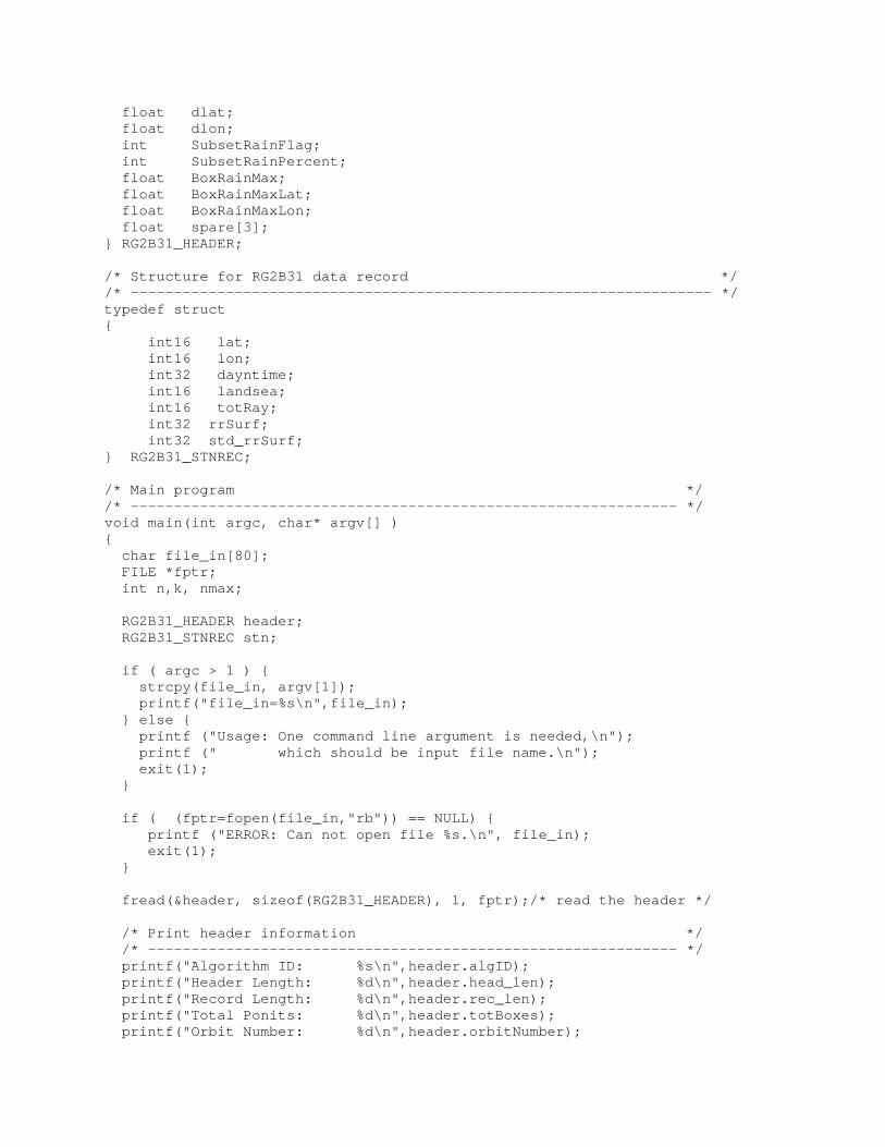
float dlat; float dlon; int SubsetRainFlag; int SubsetRainPercent; float BoxRainMax; float BoxRainMaxLat; float BoxRainMaxLon; float spare[3]; } RG2B31_HEADER; /* Structure for RG2B31 data record */ /* ------------------------------------------------------------------- */ typedef struct { int16 lat; int16 lon; int32 dayntime; int16 landsea; int16 totRay; int32 rrSurf; int32 std_rrSurf; } RG2B31_STNREC; /* Main program */ /* --------------------------------------------------------------- */ void main(int argc, char* argv[] ) { char file_in[80]; FILE *fptr; int n,k, nmax; RG2B31_HEADER header; RG2B31_STNREC stn; if ( argc > 1 ) { strcpy(file_in, argv[1]); printf("file_in=%s\n",file_in); } else { printf ("Usage: One command line argument is needed,\n"); printf (" which should be input file name.\n"); exit(1); } if ( (fptr=fopen(file_in,"rb")) == NULL) { printf ("ERROR: Can not open file %s.\n", file_in); exit(1); } fread(&header, sizeof(RG2B31_HEADER), 1, fptr);/* read the header */ /* Print header information */ /* ------------------------------------------------------------- */ printf("Algorithm ID: %s\n",header.algID); printf("Header Length: %d\n",header.head_len); printf("Record Length: %d\n",header.rec_len); printf("Total Ponits: %d\n",header.totBoxes); printf("Orbit Number: %d\n",header.orbitNumber);

printf("Begin Date & Time: %d %6.6d\n", header.beginDate,header.beginTime); printf("End Date and Time: %d %6.6d\n", header.endDate,header.endTime); printf("lonMaxlat: %-9.3f\n",header.lonMaxLat); printf("Area: %10.3f,%10.3f, %10.3f, %10.3f\n", header.lat0,header.lon0, header.late,header.lone); printf("Resolution: %10.3f,%10.3f\n", header.dlat,header.dlon); printf("SubsetRainFlag: %-d \n",header.SubsetRainFlag); printf("SubsetRainPercent: %-d \n",header.SubsetRainPercent); printf("BoxRainMax: %-f, at (%f, %f) \n",header.BoxRainMax, header.BoxRainMaxLat, header.BoxRainMaxLon); /* Print data records */ /* ------------------------------------------------------------- */ nmax = header.totBoxes; printf("\n\n"); for (n=1; n <= nmax; n++) { fread(&stn, sizeof(RG2B31_STNREC), 1, fptr);/* read nth record */ /* Print the variables for your checking. Here is the place */ /* to insert your own code to save the data foe each grid. */ /* -------------------------------------------------------- */ printf("%8d %8d %8d %8d %4d %8d %8d %8d\n", n, stn.lat, stn.lon, stn.dayntime, stn.landsea, stn.totRay, stn.rrSurf, stn.std_rrSurf); } close (fptr); } SAMPLE READ PROGRAM IN IDL: --------------------------- ; ************************************************************************ ; * ; * Program Name: ; * ------------ ; * g2b31_region.pro ; * ; * Description: ; * ----------- ; * This program shows how to read a gridded 2B31 ; * binary file and use IDL to display the data. ; * The program requires IDL has been successfully ; * installed. ; * ; * To run this example under Unix, enter idl at the ; * operating system prompt. Type in ; * 'run g2b31_region.pro' and two images will be ; * displayed. ; * ; * Contact Info. ; * --------------- ; * Dr. Zhong Liu

; * GES DISC/GSFC/NASA ; * [email protected] ; * ; * Date Author Name Change Description ; * ----------- ------------ ------------------ ; * 09-Sept-1999 Zhong Liu, GMU Created ; * ; * Modification History: ; * ; * Date Author Name Change Description ; * ----------- ------------ ------------------ ; * ; * ; ************************************************************************ PRO DISPLAY, data, lat0, lon0, late, lone, factor, beginDate, $ endDate, beginTime, endTime, orbitNumber, dlat, dlon, $ title, window_no ;WINDOW, window_no, XSIZE=500, YSIZE=500, RETAIN=2, /PIXMAP WINDOW, window_no, XSIZE=500, YSIZE=500, RETAIN=2, /PIXMAP MAP_SET, /MERC, $ LIMIT=[lat0, lon0, late, lone], $ TITLE=title img = MAP_IMAGE(data,Startx,Starty, COMPRESS=4, $ LATMIN=lat0, LONMIN=lon0, $ LATMAX=late, LONMAX=lone, $ MISSING=-9999.0) img=img/factor indices=where(img lt 0.0, count); missing data count img_byt = img img_byt[indices] = 0.0 img_byt=BYTSCL(img_byt) TV, img_byt, Startx, Starty MAP_GRID, LATDEL=3, LONDEL=5, /LABEL MAP_CONTINENTS, /COASTS img_tmp=TVRD() WDELETE, window_no ;Create the color bar c_bar=bytarr(256, 20) FOR i=0,255 DO BEGIN c_bar[i,*]=BYTE(i) ENDFOR WINDOW, window_no , XSIZE=500, YSIZE=600, RETAIN=2 TV, img_tmp, 0, 100 TV, c_bar, 125, 70 XYOUTS, 10, 35, 'For Date From ' + STRING(beginDate) + ' To ' + $ STRING(endDate), /DEVICE XYOUTS, 10, 20, 'For Time From ' + STRING(beginTime) + ' To ' + $ STRING(endTime), /DEVICE

XYOUTS, 10, 5, 'Orbit No.: ' + STRCOMPRESS(STRING(orbitNumber)) + ' ' + $ 'Dlat: ' + STRCOMPRESS(STRING(dlat)) + ' ' + $ 'Dlon: ' + STRCOMPRESS(STRING(dlon)), /DEVICE END ;Set NX, NY, NZ NZ = 2 NX=401 & NY=351 ;Create header and record structures STR8 = STRING(REPLICATE(8B, 8)) STR40 = STRING(REPLICATE(40B, 40)) header = {algID:STR8, region:STR40, head_len:0L, $ rec_len:0L, totBoxes:0L, orbitNumber:0L, $ beginDate:0L, endDate:0L, beginTime:0L, $ endTime:0L, lonMaxLat:0.0, lat0:0.0, $ lon0:0.0, late:0.0, lone:0.0, dlat:0.0, $ dlon:0.0, RainMax:0.0, RainMaxLat:0.0, $ RainMaxLon:0.0, BoxRainMax:0.0, $ BoxRainMaxLat:0.0, BoxRainMaxLon:0.0, $ dummy:FLTARR(2)} record = {lat:0, lon:0, dayntime:0L, landsea:0, $ totRay:0, rrSurf:0L, std_rrSurf:0L} openr,1,'RG2B31.19990808.9758.SCSMEX.5.BIN' readu,1,header print,'algID = ',header.algID print,'region = ',header.region print,'head_len = ',header.head_len print,'rec_len = ',header.rec_len print,'Total Points = ',header.totBoxes print,'OrbitNumber = ',header.orbitNumber print,'Begin Date = ',header.beginDate print,'End Date = ',header.endDate print,'Begin Time = ',header.beginTime print,'End Time = ',header.endTime print,'LonMaxLat = ',header.lonMaxLat print,'Start Lat = ',header.lat0 print,'Start Lon = ',header.lon0 print,'End Lat = ',header.late print,'End Lon = ',header.lone print,'Dlat = ',header.dlat print,'Dlon = ',header.dlon ; Create an array to hold radiance srr = REPLICATE(-9999.0, NX, NY, NZ) max = header.totBoxes FOR n=1,max DO BEGIN readu,1,record ;Lat, Lon to I, J conversion i=fix((record.lon-fix(header.lon0*100))/fix(header.dlon*100))+1 j=fix((record.lat-fix(header.lat0*100))/fix(header.dlat*100))+1

if (record.rrSurf lt 0.0) then $ srr[i-1,j-1,0]= -9999.0 $ else $ srr[i-1,j-1,0]= float(record.rrSurf) if (record.std_rrSurf lt 0.0) then $ srr[i-1,j-1,1]= -9999.0 $ else $ srr[i-1,j-1,1]= float(record.std_rrSurf) ENDFOR LOADCT, 27; EOS B color table DISPLAY, srr[*,*,0], header.lat0, header.lon0, header.late, $ header.lone, 100.0, header.beginDate, header.endDate, $ header.beginTime, header.endTime, $ header.orbitNumber, header.dlat, header.dlon, $ 'G2B31 Surface Rain Rate Image', 1 DISPLAY, srr[*,*,1], header.lat0, header.lon0, header.late, $ header.lone, 100.0, header.beginDate, header.endDate, $ header.beginTime, header.endTime, $ header.orbitNumber, header.dlat, header.dlon, $ 'G2B31 Surface Rain Rate Std. Dev. Image', 2 close, 1 free_lun, 1 end *********************************************************
References
[To Be Provided at a later date.]
Data Access
Anonymous FTP The Geographical Subsets of the TRMM Combined TMI and PR Gridded Orbital data set may be accessed either directly from this document,
ftp://disc2.nascom.nasa.gov/data/s4pa/TRMM_L2/TRMM_G2B31/
or via anonymous FTP at ftp disc2.nascom.nasa.gov login: anonymous password: < your internet address > cd /data/s4pa/TRMM_L2/TRMM_G2B31

Points of Contact
DISC Help Desk: For information about or assistance in using any DISC data, contact the DISC Help Desk at:
Goddard Earth Sciences Data and Information Services Center Code 610.2 NASA Goddard Space Flight Center Greenbelt, Maryland 20771 Email: [email protected] 301-614-5224 (voice) 301-614-5268 (fax)
Data Producers: The Principal Investigator for the original Combined TMI and PR 2B31 data set is:
Dr. Christian Kummerow Laboratory for Atmospheres / Code 912 NASA Goddard Space Flight Center Greenbelt, Maryland 20771 Email: [email protected] 301-286-6299 (voice) 301-286-1762 (fax)
The producer of the geographical subsets of the Combined TMI and PR gridded 2B31 product is:
Goddard DAAC Hydrology Data Support Team Distributed Active Archive Center / Code 902 NASA Goddard Space Flight Center Greenbelt, Maryland 20771 Email: [email protected]


