
R&D Report 1957-14 - BBCdownloads.bbc.co.uk/rd/pubs/reports/1957-14.pdf( 1957/14) THE BRITISH...
17
RESEARCH DEPARTMENT TELEV 151 ON SERV ICE - ISLE OF MAN Report No. K- 126 ( 1957/14) THE BRITISH BROADCASTING CORPORATION ENGINEERING DIVISION
Transcript of R&D Report 1957-14 - BBCdownloads.bbc.co.uk/rd/pubs/reports/1957-14.pdf( 1957/14) THE BRITISH...

RESEARCH DEPARTMENT
TELEV 151 ON SERV ICE - ISLE OF MAN
Report No. K- 126
( 1957/14)
THE BRITISH BROADCASTING CORPORATION
ENGINEERING DIVISION

RESEARCH DEPARTMENT
T E l E V I S ION SE RV ICE - I S lE 0 F M AN
G.I. Ross C.J. Wh i te D.W. Taplin, Grad.I.E.E. J • Hall J. Rhodes
Report No. K-126
( 1957/14)
--(W. Proctor Wi lson)

This Report is the property of the British Broadcasting Corporation and may Dot be reproduced in any form without the written permission of the Corporation.

Report No. K-l26
TELEVISION SERVICE - ISLE OF MAN
Section Title Page
SUMMARY • • • • • • • • • • • • • • • • • • • • • • • • • • • • • • • 1
1 INTRODUCTION • • • • • • • • • • • • • • • • • • • • • • • • • • • • 1
2 GENERAL • • • • • • • • • • • • • • • • • • • • • • • • • • • • • • • 2
3 ELECTRI CAL INTERFERENCE IN THE I SLE OF MAN • • • • • • • • • • • • • 2
4 THE SERVICE IN THE ISLE OF MAN FROM DIVIS AND THAT EXPECTED FROM THE
PERMANENT SANDALE TRANSMITTER • 3
5 THE SNAEFELL AND DOUGLAS (CARNANE) SITES • • • • • • • • • • • • • • 6
6 TELEVI SION LINK WI TH THE MAINLAND • • • • • • • • • • • • • • • • • • 9
7 CONCLUSIONS • • • • • • • • • • • • • • • • • • • • • • • • • • .'. 11
8 REFERENCE. • • • .,' 11
APPENDIX • • • • • • • • • • • • • • • • • • • • • • • • • • • • •• 13

June 1957
SUMMARY
Report No. K-126
( 1957/14)
TELEyr SrON SERyr CE - r SLE OF MAN
The problem of providing the Isle of Man with a television service in Band I is discussed, It is shown that the west coast of the Island, including Peel, receives a satisfactory service from Divis and the northern sector, including Ramsey, will receive a satisfactory service from the proposed transmitter at Sandale.
Because these areas will be so served and because a temporary transmitter already serves Douglas with a much stronger signal than could be provided from Snaefell, it is recommended that the Snaefell site originally chosen to serve the whoLe Island should be abandoned in favour of the site used for the temporary service at Carnane, near Douglas,
A site on Snaefell should, however, be used as a receiving point for direct pick-up of the television programme from either Sandale, Holme Moss or Divis.
1, INTRODUCTION
The television distribution plan provides for a low-power transmitter to serve the Isle of Man with a vertically polarised transmission on Channel 5, The obvious choice of a site for this transmitter was the summit of Snaefell, the highest point of the Island (2038 ft (621 m) above sea level), The use of this site was originally considered in 1953 but, because of difficulties arising from sharing the site with the Ministry of Transport and Civil Aviation, who operate a radio station for air to ground communication, the scheme was at that time abandoned and an alternative site sought.
A temporary low-power transmitter was then brought into service at Carnane, a site overlooking Douglas, and it was recommended that the effective radiated power (e.r.p.) shOUld be 1 watt. Unfortunately, local pressure resulted in the power being increased to 250 watts with the result that the median field strength in Douglas was increased from 2'5 mV/m to 40 mV/m,
An alternative site to Snaefell for the permanent transmitter was found at Injebreck Hill but tests 1 showed that this site would give only a very poor service in parts of Douglas and at the southern end of the Island. The report concluded: "Many complaints would be received from viewers who are getting a satisfactory service from the temporary transmitter at Douglas (Carnane) if the service were transferred to Injebreck Hill".
As a result of this, further consideration was given to siting the transmitter on Snaefell, Negotiations were reopened with the M.T.C.A. and tests were made to determine the degree of interference their service would suffer if the B.B.C. operated

2
a lo~power station on a shoulder some 1000 ft (305 m) south-west of the summit and 1957 ft (596 m) above mean sea level. These initial tests were successful and were followed by the survey described in this report.
2. GENERAL
The test transmissions from Snaefell consisted of a peak-white picture and line synchronisation pulses radiated by a 50o-watt vision transmitter driving two dipoles stacked vertically, their centres spaced ~A. from one another and spaced itA. from a 5~ in, (14 cm) diameter tubular mast. The height of the centre of the aerial was 88°5 ft (27 m) above ground level. The directional properties of this aerial were allowed for and all field strengths quoted have been corrected to correspond to the value for an omnidirectional aerial and an e,r.p. of 0'8 kW.
When the weather permitted, the test transmissions were radiated by a balloon-borne aerial up to a maximum height of 300 ft (91'4 m) above ground level. All field strength measurements were made with a receiving aerial 15 ft (4°6 m) above ground level but they have been corrected, on a linear height-gain basis, to the values for 30 ft (9' 2 m) above ground level.
Observations of the transmission when modulated with "spike" or Test Card C were made at a number of points in the Island in order to determine the degree of sea scatter interference* that would arise if the permanent transmitter were sited on Snaefell.
The field strength of the Divis and Sandale (temporary) transmissions was also measured to determine the effectiveness of the coverage over the western and northern areas of the Island.
Details of all relevant sites are given in the Appendix.
3. ELECTRICAL INTERFERENCE IN THE ISLE OF MAN
The electric power distribution lines on the Island cause very serious interference with the reception of television signals. With the exception of Douglas, the entire Island is served by 11 kVand 33 kV lines, and, under most atmospheric conditions, serious arcing occurs. The precise mechanism of the arcing is not known but the intensity of the interference, which varies with the time and
,location, is often very severe,
*Sea scatter interference is the subject of a Researoh Department report to be published shortly. Briefly, this form of interferenoe may be experienced at a receiving point within about one mile (1'6 km) of the sea, severely screened from the transmitting source by a local obstruction, if the surfaoe of the sea is illuminated by a strong field within a few miles of ~he shore~ In ~hese circumstances the direct signal is seriously attenuated but, nnder certain sea oonditions, a relatively strong soattered Signal is reoeived from the sea, which is alternately in and out of phase with the direot signal due to the motion of the waves. The interference manifests itself as a series Of ghosts of diminishing amplitude and rhythmic change of phase. When the interference is severe the synchronising pulses are so blurred as to cause the picture to disintegrateo

3
It is not possible to state the field strength required to suppress the interference in all areas of the Island but it is felt that 0'5 mV/m should provide reasonable reception for most of the time, except in cases of severe interference.
4. THE SERVICE IN THE ISLE OF MAN FROM DIVIS AND THAT EXPECTED FROM THE PERMANENT SANDALE TRANSMITTER
In considering the siting of the permanent transmitter in the Isle of Man account must be taken of the service now provided by Divis and that which will be provided by Sandale when it comes into full service.
A survey (including, on account of power line interference, sample viewing) of the service from Divis was carried out, and the results are presented in a field strength contour map in Fig. 1 (map T.357). The service expected from Sandale (final condition), based on measurements of the temporary transmissions, is shown in Fig. 2 (map T.35Sl.
From Fig. 1 it will be seen that Divis now provides the whole of the Island, except the east coast, with a field strength of at least 0'1 mV/m and that the west coast towns of Port Erin, Peel and Jurby all receive median field strengths in excess of 0'5 mV/m. The Sandale transmitter in its final condition is expected to serve the northern plain, the median field strength in Ramsey being 1'0 mV/m.
The field strengths in the principal towns in the Island from Divis and Sandale are tabulated in Table 1.
Town
Douglas Ramsey Peel Laxey Castletown Port Erin Port St. Mary
T.ABLE 1
Field Strength in mV/m at 30 ft (9'2 m) .AGL
DIVIS E.R.P. 12 kW
Measured Max. Median Min.
0'9 0-9 1-6 0-14 0-7 2'0 1-0
0-18 0-26 0'56
Noise 0'09 0-18
0-04 Noise 0- 33 0-18 0'5 0'09 O' 32 0-1
SANDALE E.R.P. 25 kW in I.o.M. direction
Derived from lo~power measurements Max. Median Min.
3-0 0'35
The field strength in the other towns was too weak for accurate measurement on the present lo~ power condition.
From Table 1 it will be seen that many towns on the south and west coasts of the Island receive a field strength from Divis which, in the absence of power line interference, would provide a good service. Because of this interference subjective tests were made at a number of towns including Peel, Port Erin and Ramsey. Two visits were made to Peel. On the first occasion the interference was severe in one locality whilst on the second it was negligible in all parts of the town. In Port Erin the interference, generally, was graded as being nslightly disturbing n•

4
DIVIS Field strengTh contours in the I.O.M.
(Measured) Channel 1 (45 Mc/s)
Site Height: 1200 t1: (365m) AMSL Aerial Height: 475 t1: (r45m) AGL E.R.P. : 12 kW Aerial: 3 tier super turnstile Polarisation: Horizontal
/
Q 0:5
IT3571
Fig.l
Point ot Ayre
1 O'S
axey
Clay Head
os. GLAS , 0·1
NOTE: The contours represent the 'field strength in mY/m 30tt (9·2 m) above ground uceeded a1: 50 Ofo 01' the receiving SItes in a given locality. The value excuded at 90% 01' the receiving sites may be as much as 10 dB below the value indicated by the contours particularly In hilly and bu ilt - up areas.
~ Scale Cal1' OT Man 5 5 10 Miles
~I~~====~~====~~==~~======~I 5 5 10 15 Kilome"tres ~1~F3~=F3=-=2=======3I========~I=======s1

SANDALE Field strength contours in the lO.M.
(Derived from measureJ'!'lents of temporary low power transmItter)
Channel4 (151·75 Mc/s) Site Height: 1192ft (364m) AMSL Aerial Heig'ht: 415 ft (J 2 6·5m) AGL E. R.P: .*. 27 kW Aerial: 4tier Batwing V Polarisation: Horizontal
.*. In direction of Ramsey LO.M.
Bradda Head
5 I
oPeel
o Patrick
oSt.John'$
South Barrule
0 Scale
I
~ 0 E3 E3 I
5 I
Point of Ayre
2
"
5
IT358.1
Fig.2
o Maughold
snaefen&~:>/
0.2<;,:
5 I
-, Q.
",', Laxey
NOTE: The contours represent the fie Id strength in mVlm 30 ft (9'2 m) above ground exceeded at 50% of the receiving sites in a given locality, The value exceeded at 90% of the receiving sites may be os much as 10dB below the value indicated by the -contours particularly in hilly and built-up areas,
10 Miles I
10 15 Kilometres I I
6
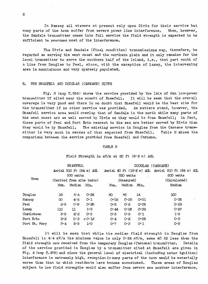
In Ramsey all viewers at present rely upon Divis for their service but many parts of the town suffer from severe power line interference. When, however, the Sandale transmitter comes into full service the field strength is expected to be sufficient to overcome most of the interference.
The Divis and Sandale (final condition) transmissions may, therefore, be regarded as serving the west coast and the northern plain and it only remains for the local transmitter to serve the southern half of the Island, i~e., that part south of a line from Douglas to Peel, since, with the exception of Laxey, the intervening area is mountainous and very sparsely populated.
5. THE SNAEFELL AND DOUGLAS (CARNANE) SITES
Fig. 3 (map T.354) shows the service provided by the Isle of Man low-power transmitter if sited near the summit of Snaefell. It will be seen that the overall coverage is very good and there is no doubt that Snaefell would be the best site for the transmitter if no other service was provided, As matters stand, however, the Snaefell service area would overlap that of Sandale in the north while many parts of the west coast are as well served by Divis as they would be from Snaefell; in fact, those parts of Peel and Port Erin nearest to the sea are better served by Divis than they would be by Snaefell. The existing service in Douglas from the Carnane transmitter is very much in excess of that expected from Snaefell. Table 2 shows the comparison between the service provided from Snaefell and Carnane.
TABLE 2
Field Strength in mV/m at 30 ft (9'2 m) AGL
SNAEFELL DOUGLAS (CARNANE) Aerial 210 ft (64 m) AGL Aerial 40 ft (12'2 m) .AGL Aeri al 210 ft (64 m) .AGL
800 watts 250 watts 8CO watts Town (Derived from site tests) (Measured) (Calculated)
Max. Median Min. Max. Median Min. Median
Douglas 32 4'4 0'24 80 46 14 100 Ramsey 3:) 4'5 0'1 0'03 0'02 0'01 O'CS Peel 3'S O'g 0'25 0'6 0'2 0'05 0'53 Laxey 110 11 1'3 0'44 0'06 0'03 0'27 Castletown 5'S 2'2 0'6 0'5 0'3 0'1 l'S Port Erin 2'2 0'3 <0'13 0'4 0'2 0'05 0'5 Port St. Mary 5'4 2'5 1'0 0'7 0'3 0'1 0'9
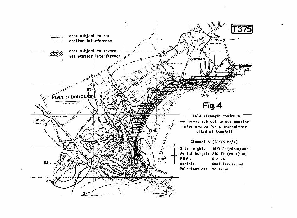
It will be seen that while the median field strength in Douglas from Snaefell is 4'4 mV/m the minimum value is only 0'24 mV/m. some 40 dB less. than the field strength now received from the temporary Douglas (Carnane) transmitter. Details of the service provided in Douglas by a transmitter sited at Snaefell are given in Fig. 4 (map T.375) and since the general level of electrical (including motor ignition) interference is extremely high, reception in many parts of the town would be materially worse than that to which residents have become accustomed. Those areas of Douglas subject to low field strengths would also suffer from severe sea scatter interference.

SNAEFELL (Derived from site test measurement)
ChannelS (66, 7S MC/S )
Site Height: Aerial Height: E. R.P. Aerial: Polarisation:
19S7 ft (S96m) AMSL 210ft (64m) AGL 0·8kW Omnidirectional Vertical
Jurby o
5
AndreQs o
IT3541
Fig.3
Point of Ayre
'~~ B HQugh 5
5cale
North 0" ,,_
Barrulel .. '
5NAEFELL
Sl~
NOTE:
Q Maughold
The contours represent the fi.ld strength in mV/m 30ft 19' 2 m) above ground exceed.d at 500~ of thlZ receiving sites in a given locality ThlZ value ItXcudczd at 90 0/0 of the receiving sites may be as much os 10 dB below the value indicated by the contours particularly in hilly and built-up
5 0 5 I !
5 0 5 10
10 areas.
l::::::::E==:l==~=::I=======~====3::::~======::;;:::r;1 Miles 15 Kilometres
I e-3 e-3 I I I ~==~=k====~C======E=====51
7
area su bj ect to sea scatter interference
area subject to severe sea scatter interference
k:~~
/~ ~- LAN OF DOU ~ I'''~ "'", •• '''
I
I i
IT 3751
Fig. 4 Field strength contours
and areas subject to sea scatter interference for a transmitter
sited at Snaefell
Channel 5 (66 0 75 Mc/s)
Si te hei ght: 1957 ft (596 m) AMSL Aerial height: 210 ft (6~ m) AGL ER P : 0 0 8 kW Aerial: Omnidirectional Polarisation: Vertical

9
Subjective tests made in many parts of the Island showed that parts of Laxey and Ramsey as well as those parts of Douglas near the front would suffer varying degrees of this interference and that, in some areas, it would be serious. Douglas subject to sea scatter effects are shown in Fig. 4.
The areas of
Finally, the possibility of siting the permanent low-power station on or very near the site of the temporary station at Douglas (Carnane) is considered. The service area for this site, estimated from field strength measurements of the temporary transmitter, is given in Fig. 5 (map T.362) and Table 2. Douglas would receive a median field strength of about 100 mV/m and all viewers on the Island who have in the past received their service from the temporary station would, of course, receive an enhanced signal. As in the case of Snaefell, however, certain parts of the west coast would be better served by Divis. Douglas (Carnane) would not contribute anything to the service in the northern plain and, although the field strength in Laxey will be enhanced, it will not provide a strong enough signal to overcome power line interference, especially in the lower parts of the town.
6. TELEVISION LINK WITH THE MAINLAND
The present arrangement for feeding programme to Douglas (Carnane) is direct pick-up of the programme from Holme Moss. This radio link is subject to severe fading and during the summer months continental co-channel interference, due to propagation by Sporadic E, is sometimes very serious.
It is proposed to establish a receiving post on the summit of Snaefell, where the field strength from Holme Moss is substantially greater than it i~ at Douglas (Carnane), and feed the programme to Carnane by an S.H.F. link. The field strength of Holme Moss on the temporary transmitter site near the summit of Snaefell was recorded for 163 hours with a receiving aerial 30 ft (9°2 m) above ground level. Details of the observations are given in Table 3.
Percentage Time
Field strength (mV/m) 30 ft (9°2 m) AGL exceeded for given percentage time
TABLE 3
50 60
2
70
1'75
80 90 95 99 100
0'5
The signal stability of Holme Moss on Snaefell should, therefore, be satisfactory but the Sandale transmissions should provide a more satisfactory link for the following reasons:
i. The field strength, even while Sandale is running a temporary service, should be adequate for first-class reception.
ii. Sandale is only 63 miles (101 km) distant, whereas Holme Moss is 118 miles (190 km). Fading should, therefore, be negligible,
iii. Signals from Sandale, on Channel 4, will be subject to much less Sporadic E interference than those from Holme Moss on Channel 2.

10
DOUGLAS (CARNANE) (E st i maTed)
Channel 5 (66·75 Mc/s) Site Height: 491ft (J49m) AMSL Aerial HC'ljght: 210ft (64 m) AGL E.R.P.: 0·8 kW Atlrial: Omnidirectional Polarisation: VC'l rt'ica I
Population within
SmV/m Z 6,900
0'5mV/m 39,300
O·lmV/m 44,600 o &ollough
QO.5 Coli-oi Man
\T362\
Fig.S
Poin1: of Ayre
O·z o M6ughold
NOTE: Th~ contours represent the field strength In mY/m 30 ft (9·2 m) above ground exceeded at 50% of the receiving sites in 0 given locality. The value exceeded at 900io of the receiVing sites may be os much os 10 dB below the value indicated by the contours particularly in hilly and built-up areas.
5):1 ==c:::::~===:c:=;!:========§'===~~==~======:=:;;::{lp Hi les 10 15 Kilome1:res , ,

iv, Because the Sandale transmissions are horizontally polarised and because of the geographic disposition of the Sandale/Snaefell link in relation to the continent a large measure of discrimination against Sporadic E interference should be possible by suitably orienting the aerial. Further, since the field strength from Sandale will be much in excess of the minimum required for good reception it may be worth while considering erecting a low receiving aerial at Snaefell with a view to steering it for minimum interference under any given set of conditions. Adjustment of directivity will also be necessary to avoid co-channel interference from Meldrum.
11
The field strength of Divis was also measured near the summit of Snaefell and the transmission provides a strong reliable signal for R.B.R. purposes if required.
7. CONCLUSIONS
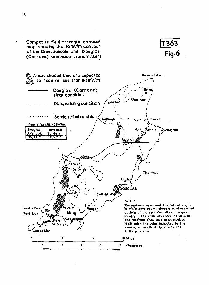
Having shown that Sandale (final condition) will provide a field strength of at least 0·5 mV/m in the northern plain, that Divis n?w provides not less than 0·5 mV/m to the west coast and that if the low-power transmitter be sited on Snaefell parts of Douglas would be subject to very poor reception, it is concluded that Douglas (Carnane) is the best site for the Isle of Man permanent station. With this arrangement (see composite map T.363, Fig. 6) Engineering Information Department have estimated that 95% of the Island's population will receive a field strength in excess of 0'5 mV/m. To site the transmitter at Snaefell would undoubtedly cause complaints from viewers in large areas of Douglas who would receive a much degraded picture compared with that to which they are accustomed. Furthermore, reception of Snaefell in parts of Ramsey, Douglas and Laxey would be seriously marred by sea scatter interference.
A receiving post will, however, have to be established on Snaefell if a good programme link is to be provided'for the permanent station and it is recommended that, whenever practicable, the Sandale transmission should be used.
8. REFERENCE
1. Research Department Report No. K-103 (1955/7), "Television Service for Isle of Man- Site Test at Injebreck Hill".
12
Composite field strength contour map showing the O'5mV/m contour of the Divis"Sandale and Douglas (Carnane) television transmitters
~_ Areas shaded thus arc expected • to receive less than O·5mV/m
Douglas (Carnane) final condition
- - - - - Divis, existing condition
.... . . . . . . . . Sandale,fina\ condition
Po ulatlon within O·SmV/m.
Douglas Divis and (c.arnane) Sandale 39,300 12,700
IT363 \ Fig. 6
Point of Ayre
NOTE; The cont.ours represent the field strength in mV/m 30ft t9·2m) above ground exceeded at 50Dt. of the rece..iving sites in a given 10cal1ty. The value exceeded at 900 /. of the receiving sites may be as much as 10 dB below t.he value indicat.ed by the contours particularly in hilly and bullt·up areas
5 0 5 10 Miles I e----. ES3 C=~~~~~========31========~1
5 0 s 10 15 Kilometres I E±! E"3 CE~=C~====~====E===~I
APPENDIX
Snaefell
Latitude: Longitude: Grid Reference: Height above sea level:
Douglas (Carnane)
Latitude: Longitude: Grid Reference: Height above sea level:
54° 15' 40" N 04° Zl' 49" W 24 (SC) /396880 195'7 ft (596 m)
54° 08' 25" N 04° 29' '32" W 24(SC)/373746 491 ft (149 m)
13


![THE COPYRIGHT ACT, 1957 ACT O OF 1957THE COPYRIGHT ACT, 1957 ACT NO. 14 OF 1957 [4 th June, 1957] An Act to amend and consolidate the law relating to copyright. BE it enacted by Parliament](https://static.fdocuments.in/doc/165x107/5ea2f5218049777fb34c4d95/the-copyright-act-1957-act-o-of-1957-the-copyright-act-1957-act-no-14-of-1957.jpg)

