Raven Monitoring, Removal, and Management within Desert ... · In addition, determine percent...
30
Raven Monitoring, Removal, and Management within Desert Tortoise Conservation Areas 2018 Request for Proposals (RFP) Proposals are Due Wednesday, January 31, 2018 Contact for Technical Questions for the U.S. Fish & Wildlife Service (USFWS): Tara Callaway, Endangered Species Biologist, Email [email protected], Office 760-322-2070 ext. 417 Contact for Technical Questions on Bureau of Land Management (BLM) land: Mark Massar, District Wildlife Biologist, Email [email protected], Office 760-898-5367 Contact for Technical Questions for the Superior-Cronese Critical Habitat Unit (CHU) portion within Fort Irwin National Training Center: Liana M. Aker, Wildlife Biologist, Email [email protected], Office 760-380-2681 Contact for Technical Questions for the Fremont-Kramer CHU portion within Edwards Air Force Base: Wes King, Biological Scientist, Email [email protected], Office 661-277-6298 Contact for Technical Questions for the Ord-Rodman CHU portion within Barstow Marine Corps Logistics Base: Benjamin Cody Leslie, Environmental Protection Specialist, Email [email protected], Office 760-577-6744 Contact for Technical Questions for Joshua Tree National Park: Michael Vamstad, Wildlife Ecologist, Email [email protected], Office 760-367-5562 Contact for Technical Questions for Mojave National Preserve: Neal Darby, Wildlife Biologist Lead, Email [email protected], Office 760-252-6146 Contacts for NFWF Contracting and Administrative Questions: Anne Butterfield, Senior Manager, Impact-Directed Environmental Accounts, National Fish and Wildlife Foundation, Email [email protected], Office 415-243-3106 Eliza Braendel, Manager, Impact-Directed Environmental Accounts, National Fish and Wildlife Foundation, Email [email protected], Office 415-593-7628 *Proposals submitted that are incomplete or not according to the specifications detailed below will be disqualified and not evaluated. Proposals need to be submitted for each survey area separately and cannot be combined. If anything in the proposal is optional, it must be specifically noted as an option with a separate budget; otherwise if the proposal is selected, all actions detailed in proposal will be required to fulfill the contract. If the proposal references this RFP, the RFP needs to be included as an Appendix and a reference to that Appendix must be added wherever the RFP is mentioned. Introduction This survey year marks the sixth year of effort to document and monitor the extent to which nesting ravens depredate desert tortoises within high-quality and sensitive tortoise habitat in southern California (e.g., within desert tortoise critical habitat units). Selected habitat areas have rotated among the years such that each important area was surveyed over at least one breeding year. An effort was made to include locations which were known (or highly suspected) to support large numbers of
Transcript of Raven Monitoring, Removal, and Management within Desert ... · In addition, determine percent...

Raven Monitoring, Removal, and Management within Desert Tortoise Conservation Areas
2018 Request for Proposals (RFP) Proposals are Due Wednesday, January 31, 2018
Contact for Technical Questions for the U.S. Fish & Wildlife Service (USFWS): Tara Callaway, Endangered Species Biologist, Email [email protected], Office 760-322-2070 ext. 417 Contact for Technical Questions on Bureau of Land Management (BLM) land: Mark Massar, District Wildlife Biologist, Email [email protected], Office 760-898-5367 Contact for Technical Questions for the Superior-Cronese Critical Habitat Unit (CHU) portion within Fort Irwin National Training Center: Liana M. Aker, Wildlife Biologist, Email [email protected], Office 760-380-2681 Contact for Technical Questions for the Fremont-Kramer CHU portion within Edwards Air Force Base: Wes King, Biological Scientist, Email [email protected], Office 661-277-6298 Contact for Technical Questions for the Ord-Rodman CHU portion within Barstow Marine Corps Logistics Base: Benjamin Cody Leslie, Environmental Protection Specialist, Email [email protected], Office 760-577-6744 Contact for Technical Questions for Joshua Tree National Park: Michael Vamstad, Wildlife Ecologist, Email [email protected], Office 760-367-5562 Contact for Technical Questions for Mojave National Preserve: Neal Darby, Wildlife Biologist Lead, Email [email protected], Office 760-252-6146 Contacts for NFWF Contracting and Administrative Questions: Anne Butterfield, Senior Manager, Impact-Directed Environmental Accounts, National Fish and Wildlife Foundation, Email [email protected], Office 415-243-3106 Eliza Braendel, Manager, Impact-Directed Environmental Accounts, National Fish and Wildlife Foundation, Email [email protected], Office 415-593-7628 *Proposals submitted that are incomplete or not according to the specifications detailed below will be disqualified and not evaluated. Proposals need to be submitted for each survey area separately and cannot be combined. If anything in the proposal is optional, it must be specifically noted as an option with a separate budget; otherwise if the proposal is selected, all actions detailed in proposal will be required to fulfill the contract. If the proposal references this RFP, the RFP needs to be included as an Appendix and a reference to that Appendix must be added wherever the RFP is mentioned. Introduction This survey year marks the sixth year of effort to document and monitor the extent to which nesting ravens depredate desert tortoises within high-quality and sensitive tortoise habitat in southern California (e.g., within desert tortoise critical habitat units). Selected habitat areas have rotated among the years such that each important area was surveyed over at least one breeding year. An effort was made to include locations which were known (or highly suspected) to support large numbers of

breeding ravens over multiple years to gain a better understanding of the extent of the depredation problem, to identify trends regarding the rate of occurrence of “offending ravens”, and to begin to document the rate of success of current removal methods of offending individuals. We now have a clearer view of the issues contributing to the unnaturally-high densities of breeding ravens in the desert and are beginning to develop an understanding of the impact breeding raven foraging habits may have on the desert tortoise in relation to localized human subsidies. This next year of data collection seeks to further clarify the role of human-caused subsidies in the raven mega-population phenomenon and to continue the process of addressing feasible management actions (currently available as well as in preliminary development phases) that may offer low-cost, long-term, and effective solutions. 1) Performance Period and Total Survey Effort
Work will be performed over a three and a half month period from March 19 through June 30 in priority areas (Attachment One). Total survey effort will be clearly detailed in the proposal by person days along with the number of hours per person day. Project administration and fieldwork (nest monitoring and subsidy characterization) efforts will be separated and described clearly by total person days for each category. Project administration and fieldwork person days will be further broken down by specific tasks such as, but not limited to, database management, nest monitoring and human subsidy characterization effort.
2) Budget Budget descriptions need to be estimated clearly and broken down by tasks such as, but not limited to: nest monitoring, management activities (if applicable), subsidy characterization, database management, project administration, hotel rate (cost per day and number of days), camp rate (cost per day and number of days), mileage (cost per mile by number of estimated miles), pellet analysis (number of days and cost per day), equipment/supplies (total cost), and overhead (percent of labor). Nest monitoring, subsidy characterization, database management, and project administration efforts need to include an estimated number of person days and cost per person day with the hours per person day. Each task will include the total cost estimates. If the budget is not clearly estimated, further evaluation of the proposal will be discontinued. Monthly financial reports will be accepted in either one of two formats. The first option that will be accepted is an estimated daily cost per person day with the total person days for that month. The first option must include an attached memo each month with a detailed description of how the person day cost was estimated from expenses and tasks. The memo can be reused each month. The second option that will be accepted is an estimated cost for each task that month such as, but not limited to, fieldwork (days multiplied by a fixed rate per day), accommodation rates (cost per day), mileage (cost per mile by number of miles), pellet analysis (cost per day), equipment/supplies (total cost), project administration (days multiplied by a fixed rate per day), and overhead (percent of labor).
3) Survey Routes
Surveys will be conducted during daylight hours (45 minutes after sunrise and 45 minutes prior to sunset) by slowly driving established open routes1 within identified priority areas
1 Open Routes are defined as routes designated as those open for motor vehicle use in a BLM land use plan (e.g. West Mojave) or by another agency as open for the use of motor vehicles. All survey efforts will occur on public lands and private land entry is not granted or authorized by National Fish and Wildlife Foundation, National Park Service, Bureau of Land Management, Renewable Energy Action Team, Desert Managers Group, or U.S. Fish and Wildlife Service.

(Attachment One) and scanning suitable common raven (Corvus corax; raven) nesting substrates with and without binoculars. Refer to Attachment Two for preferred survey routes that have been established in previous surveys. Nesting substrates, such as transmission and powerlines and other human structures, take precedence in surveying early in the monitoring season with an emphasis on nest locations that have been occupied by ravens within the previous two years2. If transmission and powerlines are predominant in area, surveys in hard to reach locations, such as cliff outcrops, should be kept to a minimal amount and are of a lower priority for surveying. However once the human structures have been surveyed, surveyors should expand their nesting substrates and look in harder to reach locations such as cliff outcrops and Joshua Tree woodlands, if necessary. In a safe manner, surveys will be conducted with one to two personnel (preference determined by contractors) in a vehicle with individual(s) observing, navigating, and driving. Speeds on dirt roads will not exceed 20 miles per hour. On paved roads, a balance will be made between safety and nest search effectiveness but posted speed limits will not be exceeded. Identified routes will be broken up into manageable lengths and driven such that both sides of the survey route are inspected thoroughly before moving on. Upon sighting a potential raven nest, the vehicle will come to a stop while the observer inspects the area and records data. Observe the birds from a distance with a high power spotting scope that will enable observation of the birds without disturbing them. The vehicle survey will re-commence when the observer’s full attention is again on the landscape. While driving open routes in one direction, the observer will look for potential nests within the field of view from the survey route. In cases of a positive or highly suspect nest, surveyors will monitor the activity to determine whether or not it is active (minimum twenty minutes), and by which species it is being used. Basic nest data will be collected in provided datasheets (e.g., nest height, substrate, and status; see Attachment Seven). If the nest is being used by ravens, observations should continue until the nesting status of the birds can be determined. Confirmed sightings of raven nests will be recorded and inspected immediately (refer to Raven Nest Inspection procedures). A primary objective is to determine the number of successful nests and the number of fledglings.
4) Site Inspections
Raven Nest Site Upon arriving at the nest site, immediately identify a 10-meter radius circular plot directly beneath the active structure being careful not to disturb the area. The plot center will be indicated with a pin flag (or other non-disruptive marking system) and a GPS reading. From plot center, 100% targeted surveying should occur within the 10-meter radius plot for evidence of desert tortoise remains. Opportunistic surveying should occur beyond the 10-meter plot if natural (i.e., Yucca spp.) and human-made structures exist beyond the nest that could be used for perching. The opportunistic surveying can occur up to 300 meters, if needed. Care should be taken not to harass the ravens, to allow for future removal efforts.
Pellet Assessment
2 Contractors will be provided the UTM coordinate locations (if available) for nests previously occupied by ravens
(since 2014) once contract has been awarded.

All pellets will be collected and analyzed per active nest and nearby perch site (within 300 meters from nest site). Upon collecting all food pellets below nest and nearby perch sites, process pellets in one of two methods. For a quick desert tortoise-food pellet assessment on site, gather all pellets under a nest or perch site and crush pellets in a bowl to view contents with a hand lens. Soak in water if pellets are too hard to crush dry. To analyze pellets to identify most food items, collect all pellets under a nest or perch site and pack in labeled paper envelopes. Store pellets in a cool, dry location until analysis. Soak dry pellets in fresh water for approximately 15 minutes until contents are separated. Place hydrated pellet contents in a .5mm sieve and rinse well with additional fresh water. Allow contents to dry and tease out items recognizable on a macroscopic scale, and record the number and types of tortoise remains. Classify food pellet remains into the following categories: invertebrate, mammal, bird, reptile (not tortoise), tortoise, other (describe), or trash. Categories should add up to 100 percent for each pellet in order to determine raven’s diet overall diet. In addition, determine percent composition of raven and red-tailed hawk diets from pellets analyzed using second method. Analyze at least 12 nests per species to determine diets and choose nests close to as well as far away from human food subsidy sources (e.g. landfill, rest area, etc.). Locations of food pellets containing suspected tortoise remains will be reported to the USFWS within 24 hours (excluding weekends and holidays) of pellet processing. If tortoise remains or predation is observed at a nest or perch site, pellets will be collected and should be recorded while waiting for a USFWS determination of disposal or removal. Pellets should be mailed to BLM contact at end of season in labeled envelopes nest id and date collected.
5) Identification of Desert Tortoise Remains
Any remains of juvenile or adult desert tortoises will be catalogued and photographed on a white background with a standard scale to clearly show the composition of identified remains. Record details on the provided datasheet (e.g., number of individuals present and length(s) of carapace; see Attachment Seven). Time since death will be based upon a standardized key from Berry and Woodman 1984 modified in 2000 (Attachment Four). Desert tortoise remains will be removed from the sample plot, labeled in separate bags after being dried, and mailed to USFWS contact at end of season.
6) Timing of Surveys
Upon identifying suitable or potential nesting substrates, active nest platforms or abandoned, active or inactive nests, conduct subsequent surveys of the site to monitor activity throughout the spring into early summer as per schedule in Table 1. Because new nests are rarely created after the end of May, new nest searches should only be conducted opportunistically after the end of May (Boarman and Heinrich 1999).
Table 1. Raven nest monitoring schedule
Status of Site Monitoring schedule
Potential substrate, no activity Monitor once per month
Potential substrate, ravens observed Monitor once bi-weekly
Nest or roost present, unconfirmed spp. Monitor once per week
Confirmed raven nest, active, no desert tortoise remains located
Monitor once per week
Confirmed raven nest, active, with desert tortoise remains located
Observe once per week, coordinated with USFWS

Confirmed raven nest, inactive3 Monitor once per week
7) Notification of Desert Tortoise Remains
In the event that desert tortoise remains are positively identified at a nest or perch site, surveyors will notify USFWS and either BLM, NPS, or military installation (depending on land ownership) contact immediately by electronic mail, if possible, or if internet coverage is limited, no later than the next business day. Surveyors will follow Attachment Five guidelines and provide USFWS with CHU, nest ID, substrate, GPS site location (easting and northing), species occupying nest, breeding development stage, number of carcasses, description of remains, age class, time since death, and date remains were found. The identified USFWS contact will notify WS, and WS will coordinate with appropriate contractors to facilitate removal. Until the ravens are successfully removed, monitoring of the nesting status should continue at a once weekly interval with coordination with USFWS and landowner contact. This monitoring should be done at a maximum distance as to not interfere with removal efforts. Once ravens are removed, the site will continue to be monitored during the course of the season for re-occupation by ravens at a rate of no less than once per week. Immediately notify USFWS and either the landowner contact if any desert tortoises are found that are roadkill. Include the location of remains (UTM coordinates), time since death, age class of tortoise, and any other pertinent information.
8) Identification of Subsidy Sites
Surveyors will identify and record new human subsidies (i.e., not recorded in prior year monitoring) opportunistically during the active nesting season. Surveyors are encouraged to employ creative approaches in identifying subsidy sites, documenting in detail the methods and results of all actions taken to do so. At a minimum, searches for subsidies should include monitoring of local raven flight patterns during periods of raven foraging forays (typically early to mid-morning and again in early evening but not necessarily limited to these periods). Driving routes searching for raven aggregations, indicating potential subsidy sites, should also be carried out. Collected data should include, but not necessarily be limited to, UTM coordinates of identified subsidies; description of the location including nature of the subsidy or subsidies being provided; photographs of the general areas and evidence of raven visitation; size and reliability of subsidy source; whether the site appears to be under commercial, private, government, or other ownership; general numbers of ravens observed and times of day and season of highest use by ravens. Raven visitation may be established by actual visual monitoring of the site, installing video or photographic equipment, or alternative methods. A detailed account of use by species would be beneficial (i.e., species list) if using any of the aforementioned methods. Coordination with management officials may be required to obtain the necessary permission before equipment installation.
9) Management Actions
After three years or more of monitoring and offending raven removals, three CHU’s have moved into Phase Two of raven management. In two of these CHU’s, egg oiling will be conducted on
3 “Confirmed, inactive” status indicates a nest that has documented historical raven use but was not considered active at time of inspection.

natural substrate nests (i.e., cliffs, rock outcrops, trees, etc.) in an effort to reduce raven fecundity, decrease recruitment, and over time, decrease raven abundances. Contractors will be responsible for acquiring necessary permits. Data from prior years will be provided to contractor to facilitate efficient nest searches in an effort oil as many nests during appropriate time. Historical nests will take precedence over searching for new nests. Nests along powerlines and transmission lines will not be oiled. Contractors are responsible for conducting efficient effectiveness monitoring to determine success of egg oiling. Other monitoring, such as nest and subsidy, will not be performed in these areas. In proposal, contractors will describe in detail the egg oiling process and timeline, as appropriate, and permits they will obtain or have already obtained.
10) Deliverables The contractor will provide the following deliverables (all GPS locations will be in UTM NAD83 datum with +/- 3m EPE). All electronic files will be compatible with Adobe Acrobat or Microsoft Office (i.e., Word, Excel), and all electronic data will be compatible with ESRI ArcMap version 10 (i.e., shapefiles or geodatabase). Data files will also be mailed via Fedex or USPS to the USFWS contact at the end of contract.
Monthly: 1. Cumulative report:
a. Summary table including total number of nests for each species that are in each breeding/development stage
b. Summary map including desert tortoise carcasses (less than a year, 1-2 years, 2-4 years, and greater than 4 years), nest locations, and live desert tortoise encounters
c. Offending raven notifications and resulting actions from WS d. Summary of desert tortoise remains and incidental live desert tortoise
encounters e. Human-caused subsidy sources not previously documented in prior monitoring
years i. Street address and/or UTM coordinates of subsidy sites
ii. A summary of each subsidy site describing the nature of all identified subsidies
iii. Ownership status or other information indicating the party responsible for the subsidy site, if known
iv. Recommendations for reducing or eliminating the subsidy source(s) v. Photographs of subsidy site
vi. *Note in monthly report if no new subsidies were located in that month 2. GPS track logs (as Arc GIS shapefiles) of all routes driven within the study areas 3. A summary Excel spreadsheet that contains (see Attachment Five):
a. Nest ID b. Nesting substrate c. Locations in UTMs (Easting, Northing) d. Breeding status of occupied nest e. Description of desert tortoise remains associated with nest or nearby perch site f. Estimated time since death for the tortoise remains g. Date found h. Location and number of raven food pellets positive for tortoise remains i. Notification of desert tortoise remains, if applicable

j. Result of WS actions 4. A summary Excel spreadsheet that contains a pellet analysis:
a. Pellet contents (invertebrates, mammal, bird, reptile (not tortoise), tortoise, other (describe), and trash
b. UTM of pellet and ID of associated nest c. Date collected
5. A summary Excel spreadsheet that contains live and dead desert tortoise observations: a. Locations in UTMs (Easting, Northing) b. Sex c. Time and date found d. Time since death (if a carcass)
6. GPS locations of all desert tortoise remains that cannot be associated with a specific raven nest or perch
7. GPS locations of all desert tortoise sightings (include roadkill)
At the end of the contract: 1. A summary Excel spreadsheet that contains (see Attachment Five):
a. Nest ID b. Nesting substrate c. Locations in UTMs (Easting, Northing) d. Breeding status of occupied nest e. Description of desert tortoise remains associated with nest or nearby perch site f. Estimated time since death for the tortoise remains g. Date found h. Location and number of raven food pellets positive for tortoise remains i. Notification of desert tortoise remains, if applicable j. Results of WS actions
2. NFWF Final Programmatic Report a. Executive summary b. Methodology c. Results
i. Nest locations in UTMs ii. Separate maps of:
1. CHU boundary with land ownerships, survey routes, and powerlines
2. nest sites (include key indicating active nests, inactive nests, bird species, and offending raven nest sites) and incidental live desert tortoise encounters and carcass locations (include raven predated and roadkill tortoises)
iii. Graphs detailing: 1. active nest substrates 2. nest occupancy by species 3. food pellet analyses
iv. Summary tables detailing: 1. food pellet analyses 2. nest success rate and outcomes including nest with incubation
or greater status, number of successful nests, total number of fledglings, average number of fledglings, number of nests failed due to WS actions, and percent successful nesting

3. desert tortoise carcasses by age class (i.e., adult, sub-adult, juvenile, and hatchling)
4. WS actions at offending common raven nest sites and effect on nest success and fledging
v. QA/QC process and assurances for data and reports vi. Subsidy sites:
1. Street address and/or UTM coordinates of subsidy sites
2. A summary of each subsidy site describing the nature of all identified subsidies
3. Ownership status or other information indicating the party responsible for the subsidy site, if known
4. Recommendations for reducing or eliminating the subsidy source(s)
5. Map of monitoring area with subsidy locations noted and include a key indicating type of subsidy such as food, water, and shelter
6. *Prior subsidy sites documented in 2016 and 2017 do not need to reported
d. Discussion i. Results in comparison to prior year’s monitoring and removal efforts
ii. Summary of management actions and effectiveness of these actions iii. Summary page of recommendations for future raven monitoring and
management actions 3. All photographs and recorded details of desert tortoise remains encountered;
photographs need to be GPS tagged 4. All photographs and recorded details of live desert tortoise observations; photographs
need to be GPS tagged 5. All photographs and recorded data of nests; photographs need to be GPS tagged 6. All photographs and recorded data of subsidy sites; photographs need to be GPS tagged 7. Scanned field datasheets as pdf’s 8. All Arc GIS shapefiles or geodatabase (i.e., shapefiles, GPS tracking files, GPS locations)
needs to be mailed electronically and physically on a flashdrive to USFWS contact 9. NFWF Final Financial Report 10. End of the season presentation of results and management recommendations. Location
of presentation will be determined at a later date. *All predatory avian species that are documented during surveys need to be reported (i.e., red tailed hawks, peregrine falcons, etc.).

Attachment One Priority Management Actions by CHU and NPS Unit for 2018
1. Joshua Tree National Park and Pinto Mountains CHU
Survey and monitor nesting, roosting, and perching sites within park (coordinate routes with park contact)
Remove offending ravens (coordinate with USFWS, BLM, NPS contact, and WS)
2. Mojave National Preserve, Piute-Fenner and Ivanpah CHU Survey and monitor nesting, roosting, and perching sites focusing on critical habitat Remove offending ravens (coordinate with USFWS, BLM, NPS contact, and WS)
3. Ord-Rodman CHU (includes portion within Barstow Marine Corps Logistics Base)
Survey and monitor nesting, roosting, and perching sites within CHU Remove offending ravens (coordinate with USFWS, BLM, Barstow Marine Corps Logistics
Base, and WS to remove ravens)
4. Fremont-Kramer CHU (includes portion within Edwards Air Force Base and Desert Tortoise Research Natural Area) Survey and monitor nesting, roosting, and perching sites within CHU Remove offending ravens (coordinate with USFWS, BLM, Edwards Air Force Base, and WS to
remove ravens)
5. Chemehuevi CHU Implement egg oiling management actions on natural nest substrates (i.e., cliffs, rock
outcrops, trees, etc.) (see #9) Conduct effectiveness monitoring on a sub-sample of eggs (i.e., 30 eggs)
6. Superior-Cronese CHU and Fort Irwin’s southeast conservation area
Implement egg oiling management actions on natural nest substrates (i.e., cliffs, rock outcrops, trees, etc.) (see #9)
Conduct effectiveness monitoring on a sub-sample of eggs (i.e., 30 eggs)
Attachment Two Survey Route Maps for 2018

Joshua Tree National Park and Pinto Mountains CHU

Mojave National Preserve and Piute-Fenner CHU
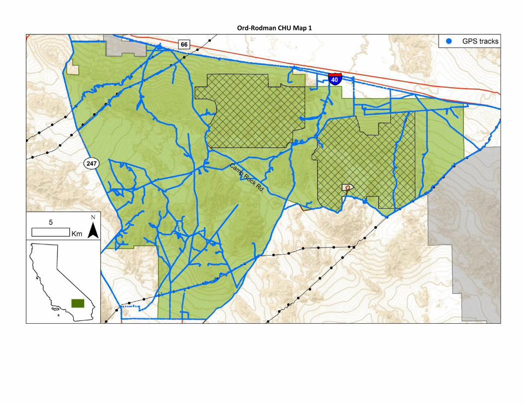
Ord-Rodman CHU Map 1

Ord-Rodman CHU Map 2 (area within Barstow Marine Corps Logistics Base)

Chemehuevi CHU

Fremont-Kramer CHU Map 1

Fremont-Kramer CHU Map 2 (CHU area within Edwards Air Force Base)

Superior-Cronese CHU and Fort Irwin’s Southeast Conservation Area

Attachment Three Key for Estimating Time Since Death for Shell-Skeletal Remains
Appendix 5 - Protocol adapted from: Berry, K.H., and A.P. Woodman. 1984. Methods used in analyzing mortality data for most tortoise populations in California, Nevada, Arizona, and Utah. Appendix 7 in Berry, K.H. (ed.), The Status of the desert tortoise (Gopherus agassizii) in the United States. Report to the U.S. Fish and Wildlife Service from the Desert Tortoise Council on Order No. 11310-0083-81.
A) Shell <50 mm MCL ...................................................................................................................B
B) Scutes may be fading slightly, and/or bone may be slightly porous with <75% bone surface pitted .................................................................................................... <1 year BB) Scutes more weathered than above; bone, if still present, extremely porous with >75% bone surface pitted............................................................................................C
C) Scutes faded, curling, may be breaking................................................. 1-2 years CC) Scutes breaking apart, very faded, curled; growth rings peeling and cracking ........................................................................................................>2 years
AA) Shell >50 mm MCL ............................................................................................................... D
D) Shell 51-120 mm MCL ..................................................................................................E
E) Scutes not fading, and/or bone solid......................................................... <1 year
EE) Scutes and/or bone more weathered than above ..............................................F
F) Scutes fading, growth rings beginning to peel, and/or bone solid or slightly porous............................................................................ 1-2 years
FF) Scutes faded; growth rings peeling, cracking, and brittle; and/or bone slightly to extremely porous................................................... G
G) Scutes faded, usually curling; growth rings peeling and cracking; <75% bone porous.............................................. 2-4 years
GG) Scutes very faded, curling, usually breaking, and/or bone extremely porous (>75%)............................................>4 years
DD) Shell >120 mm MCL ................................................................................................. H
H) Scutes not faded, and/or bone solid ......................................................... <1 year

HH) Scutes and/or bone more weathered than above ..............................................I
I) Scutes of both the plastron and carapace faded........................................J
J) Shell worn with depressed scutes............................................... K K) Very slight peeling or cracking of growth rings, and/or bone solid .................................................... 1-2 years
KK) Scutes and bone more weathered than above..............L
L) Some peeling and cracking of growth rings on scutes, and/or bone solid .............. 2-4 years
LL) Growth rings peeling and cracking, and/or bone peeling, cracking, or showing mosaic cracking............................................>4 years
JJ) Scutes on shell not depressed....................................................M
M) Growth rings not peeling or cracking, and/or bone solid ............................................................... 1-2 years
MM) Scutes and/or bones more weathered than above .................................................................................. N
N) Growth rings beginning to crack and peel on scutes, and/or bone solid ....................... 2-4 years
NN) Growth rings peeling and cracking on scutes, and /or bone peeling, cracking, or showing mosaic cracking ......................................................................>4 years
II) Scutes of either the plastron or the carapace faded, but not both.......... O
O) Shell worn with depressed scutes .............................................. P
P) Some peeling and cracking of growth rings, usually on the vertebrals, and/or bone solid ................................................................................1-2 years
PP) Scutes and/or bone more weathered than above.......... Q
Q) Growth rings on scutes peeling and cracking, usually not curled, and/or bone solid or beginning to crack and peel ....................................................................2-4 years
QQ) Growth rings on scutes peeling,

cracking, and usually curled; and/or bone solid if scutes still cover it, or peeling and cracking if exposed.......................................>4 years
OO) Scutes on shell not depressed..................................................R
R) Growth rings may be beginning to crack and peel, and/or bone solid ........................................... 1-2 years
RR) Scutes and/or bone more weathered than above.......... S
S) Scutes may be curling at edges; growth rings cracking and peeling; and/or bone solid if still covered by scutes, or may show some cracking and peeling if exposed........ 2-4 years
SS) Scutes may be curling and/or breaking, growth rings cracking and peeling, and/or
bone solid if still covered by scutes .............>4 years

Attachment Four Desert Tortoise Remains Notification Guidelines
Date Found
DTMA Nest ID
Nesting Substrate
Easting Northing Species
Breeding/ Development
Stage
Number of
Carcasses
Description of Remains
Age Class
Time Since Death
5/30/2016 Ord-Rodman ON051418-P059 Wooden Utility Support Structure
545314 3848714 CORA Fledgling 3 Disarticulated Hatchling (<60)
1-2 yrs
*Please copy and paste cells in electronic correspondence from Microsoft Excel document. Do not change order of cells above. **Describe extra details, if needed, in electronic correspondence that may aid WS to find and/or remove offending ravens such as the level of difficulty in finding nest, preferred route of travel to reach nest, compass bearings, etc.

Attachment Five Proposal Guidelines
The work described in this RFP for the CHU’s and NPS units will be performed over a four month period from approximately March 19th through June 30th, depending on the date of the notice to proceed. Once contractors are selected, the contracts will be between the contractor and NFWF. All proposals should be sent via email to Anne Butterfield at [email protected] and Eliza Braendel at [email protected] by Wednesday, January 31, 2018. Proposals should include the following information:
1. A description of how your organization plans on completing the work described in the RFP.
2. Information about the qualifications, experience and past performance for the Project Director/Principal, as well as all other staff that would contribute.
3. Your detailed budget for the activities described in the RFP. 4. Your detailed survey effort by person days and hours. 5. The tax ID number for your organization. 6. The mailing address for your organization (not a P.O. Box). 7. Financial information for your organization, as described below in Attachment Six. 8. Insurance information for your organization. If selected, please be prepared to add the
National Fish and Wildlife Foundation as additional insured.

Attachment Six Required Financial Documents
In order to consider your proposal, the Foundation requires non-Federal applicants to submit specific financial documents. ALL FINANCIAL DOCUMENTS MUST BE NO MORE THAN 2 YEARS OLD AND FROM THE SAME YEAR. State/Local Government Agencies
Certificate of Insurance. A Certificate of Insurance (COI) is a document issued by an insurance company that verifies the existence of insurance coverage. Specifically, the COI lists the effective date of the policy, the type of insurance coverage purchased, and the types and dollar amount of applicable liability. If funds are awarded, your organization must agree to obtain and maintain all appropriate insurance against liability for injury to persons or property from any and all activities undertaken by your organization and associated with the contract in any way and must have NFWF named as an additional insured on all such policies and provide NFWF with appropriate Certificates of Insurance reflecting such additions within sixty (60) days after a contract is fully executed.
Most recent GAAP Audited Financial Statements (with Auditor’s Opinion)
A-133 Audit (if applicable – for organizations which receive more than $500,000 in federal dollars in a given year)
Non-Profit Organizations / Universities
Certificate of Insurance. A Certificate of Insurance (COI) is a document issued by an insurance company that verifies the existence of insurance coverage. Specifically, the COI lists the effective date of the policy, the type of insurance coverage purchased, and the types and dollar amount of applicable liability. If funds are awarded, your organization must agree to obtain and maintain all appropriate insurance against liability for injury to persons or property from any and all activities undertaken by your organization and associated with the contract in any way and must have NFWF named as an additional insured on all such policies and provide NFWF with appropriate COI reflecting such additions within sixty (60) days after a contract is fully executed.
Most recent IRS Form 990 (Income Tax Return)
Most recent GAAP Audited Financial Statements (with Auditor’s Opinion)
A-133 Audit (if applicable – for organizations which receive more than $500,000 in federal dollars in a given year)
Certificate of Good Standing. A Certificate of Good Standing, sometimes called a Certificate of Existence or Certificate of Authorization, is a state-issued document used to demonstrate that a corporation, limited liability company, or non-profit entity exists, is authorized to do business in the state, and has complied with all state-required formalities. More information on requesting a California Certificate of Good Standing can be found here: http://kepler.sos.ca.gov/ For other states, please visit the Secretary of State website for the applicable state.
Conflict of Interest Disclosure. On a separate piece of paper, state whether your organization, or any individuals or organizations associated with your organization, has an actual or potential conflict of interest with respect to NFWF, the Scope of Work, or the subject matter of your proposal and, if so, the nature and specific details of that conflict.
Statement of Litigation. On a separate piece of paper, state any litigation (including bankruptcies) involving your organization and either a federal, state, or local government
agency as parties. This includes anticipated litigation, pending litigation, or litigation completed within the past twelve months. If your organization is not involved in any litigation, please state.
Businesses
Certificate of Insurance. A Certificate of Insurance (COI) is a document issued by an insurance company that verifies the existence of insurance coverage. Specifically, the COI lists the effective date of the policy, the type of insurance coverage purchased, and the types and dollar amount of applicable liability. If funds are awarded, your organization must agree to obtain and maintain all appropriate insurance against liability for injury to persons or property from any and all activities undertaken by your organization and associated with the contract in any way and must have NFWF named as an additional insured on all such policies and provide NFWF with appropriate COI reflecting such additions within sixty (60) days after a contract is fully executed.
Businesses are not required to submit financial documents.
Certificate of Good Standing. A Certificate of Good Standing, sometimes called a Certificate of Existence or Certificate of Authorization, is a state-issued document used to demonstrate that a corporation, limited liability company, or non-profit entity exists, is authorized to do business in the state, and has complied with all state-required formalities. More information on requesting a California Certificate of Good Standing can be found here: http://kepler.sos.ca.gov/ For other states, please visit the Secretary of State website for the applicable state.
Conflict of Interest Disclosure. On a separate piece of paper, state whether your organization, or any individuals or organizations associated with your organization, has an actual or potential conflict of interest with respect to NFWF, the Scope of Work, or the subject matter of your proposal and, if so, the nature and specific details of that conflict.
Statement of Litigation. On a separate piece of paper, state any litigation (including bankruptcies) involving your organization and either a federal, state, or local government agency as parties. This includes anticipated litigation, pending litigation, or litigation completed within the past twelve months. If your organization is not involved in any litigation, please state.
Individuals
A Certificate of Insurance (COI) is a document issued by an insurance company that verifies the existence of insurance coverage. Specifically, the COI lists the effective date of the policy, the type of insurance coverage purchased, and the types and dollar amount of applicable liability. If funds are awarded, you must agree to obtain and maintain all appropriate insurance against liability for injury to persons or property from any and all activities undertaken by you and associated with the contract in any way and must have NFWF named as an additional insured on all such policies and provide NFWF with appropriate COI reflecting such additions within sixty (60) days after a contract is fully executed.
Individuals are not required to submit financial documents.
Conflict of Interest Disclosure. On a separate piece of paper, state whether you, or any individuals or organizations associated with you, have an actual or potential conflict of interest with respect to NFWF, the Scope of Work, or the subject matter of your proposal and, if so, the nature and specific details of that conflict.
Statement of Litigation. On a separate piece of paper, state any litigation (including bankruptcies) involving you and either a federal, state, or local government agency as parties. This includes anticipated litigation, pending litigation, or litigation completed within the past twelve months. If you are not involved in any litigation, please state.

Attachment Seven Required Datasheets

Who Found Nest: Initial Detection Date: / / 201__
Study Area (Sketch the nest location on the reverse side of this sheet.)
Comments
Waypoint ID __N__ __ __ __ 1__ -__ __ __ UTM (NAD83) Zone 11S Easting: __ __ __ __ __ __ Northing: __ __ __ __ __ __ __
Best Viewed From: Easting __ __ __ __ __ __ Northing __ __ __ __ __ __ __
Habitat Topography Route
1Nest Location: 2Nest Height (m): 3Nest Aspect: Photo ID (s)
To be filled out at the end of the season
Nest Fate Cause of Failure If applicable
Total Young Observed
Total Young Observed Fledged
# Tort Remains Found
WS Action Taken?
Carc IDs of Tort # Pellets Collected Tort in Pellet?
Ob
serv
er
Dat
e
MM
/DD
/YY
Start Time (12hr
am/pm)
End Time (12hr
am/pm) 4 S
pe
cie
s U
se
# A
du
lts
Pre
sen
t
5 Bre
ed
ing/
De
velo
p.
Stag
e
# o
f Y
ou
ng
Descr of Young (Age, behavior)
Tort
ois
e
Car
cass
& #
(6 #/N
/Un
k)
Rav
en
Pe
llets
(7 Y/N
/Un
k) Dir of
Carcass Search
Transects (N-S, etc)
Exp
and
ed
Sear
ch?8
Comments: Cause of Failure or why chose B/D Stage (use
back, too)