RATS MISSON REPORT
48
Within the framework of the ACTS project: Active Tectonics and Seismic Hazard in Taiwan (ANR catastrophes telluriques et tsunamis – 2006/2009) RATS MISSON REPORT Ryukyu Arc:Tectonics and Seismology From July 19, 2008 to July 22, 2008
Transcript of RATS MISSON REPORT

Within the framework of the ACTS project: Active Tectonics and Seismic Hazard in Taiwan (ANR
catastrophes telluriques et tsunamis – 2006/2009)
RATS MISSON
REPORT
Ryukyu Arc:Tectonics and Seismology
From July 19, 2008 to July 22, 2008

Page 1
CONTENTS
I- Context – scientific purposes
II- Scientific Cruise –crew
III- Instruments
IV- Logbook
V- OBS deployment Location and relocation
ACKNOWLEDGEMENTS
The scientific French team, SERGE LALLEMAND, YVONNE FONT, FRAUKE KLINGELHOEFER and THOMAS
THEUNISSEN would like to acknowledge LAURENT BEGUERY and ROMUALD DANIEL for their high quality
technical assistance. We are grateful to Pr CHAO-SHING LEE for the management of the scientific and
logistical operation, which was successful, and the Taiwanese cooperation for ship time and scientific
exchanges. We acknowledge Pr CHAO-SHING Team (engineers, technician, assistant and students) for their
help. Moreover, we want acknowledge the entire crew of the OCEAN RESEARCHER 1 for his efficiency and
his availability and, obviously, the captain, SHIEH CC.
To conclude, we acknowledge the NSC (National Science Council via ORCIHD program) and the F-Taiwanese
foundation managed by “L’académie des sciences” for the travel support, and the ANR ACTS-Taiwan for the
working budget. For their constant help, we acknowledge the FIT (French Institute Taipei) and the BRT
(Bureau de representation de Taipei).

Page 2
I- Context – scientific purposes
The mission RATS (Ryukyu Arc: Tectonics and Seismology) is included in ACTS (Active Tectonic and seismic
Hazard in Taiwan) project (ANR Catastrophes telluriques et tsunamis) accepted in 2006. Its goal is to obtain
local marine seismic data in order to allow accurate seismologic analysis.
Taiwan is an island which results from the collision between the Eurasian plate and the Philippine Sea plate
(PSP). It is a young orogen at the geologic scale, about 2-3 Ma(Malavieille, Lallemand et al., 2002), which
has been studied mainly on land for many years and much offshore since 1990. Tectonics and seismicity are
very active in this region where the highest peaks in the central range are still uplifting at rates up to 2 to 3
centimeters per years, and where there are more than 8 earthquakes per year with magnitude higher than
5.5. The highest level of seismicity is localized in the Coastal Range (CR), the southern Ryukyu arc and
forearc area.
Figure 1 : Seismicity during the period 1991-2005 (Location by Wu, 2007(Wu, Chang et al., 2007 (accepted))).
Coastal Range
Ryukyu Arc
Okinawa
basin
Taipei
Hualien

Page 3
Figure 2 : Studied area: Southern part of the Ryukyu subduction close to the collision area of Taiwan. First image: general
geodynamic setting. The black arrow indicates the direction of relative plate motion after Yu and Kuo, 1999(Yu, Kuo et al., 1999).
The bold line with triangles indicates the plate boundaries. Second image: Diagram mapping the structural feature based on
bathymetry map. (from(Font, Liu et al., 2001)
GPS data over the last ten years show that deformation on land is likely negligible north of 24°N (Yu, Chen
et al., 1997),Angelier et al., 1997), suggesting that most of the ~8-9 cm/yr convergence rate would occur
offshore eastern Taiwan on faults that have not been yet clearly identified, giving place to large

Page 4
uncertainties for natural hazards assessment.We suspect that the plates convergence is accommodated
offshore in the northernsegment of the Longitudinal Valley Fault (LVF), within the Philippine Sea Plate (PSP)
either along the eastern submerged flank of the CR (Malavieille, Lallemand et al., 2002) or within the
subducting oceanic crust(Font, Lallemand et al., 1999).
Figure 3 : First image: Schematic tectonic map of the study area showing the kinematics of the main tectonic units (GPS data
after Yu et al., [1997]. The 95% confidence ellipse is shown at the tip of each velocity vector). ND, Northern tectonic Domain ; SD,
Southern tectonic Domain. Second image: Structural map of the study area offshore Taiwan. Geological features are drawn on
the bathymetry (shaded view, lightening N 310°E). 1 - geologic boundary, 2 - fault, 3 – large scale mud waves, 4 - drainage, 5 -
fold axis, 6 - minor fault, 7 - thrust, 8 - inactive thrust, 9 - recent collisional basin, 10 - quaternary deposits of the Longitudinal
valley, 11 – volcanic. (formMalavieille and al., 2002)
To be able to identify precisely where the shortening occurred, it is necessary to identify active faults in the
junction area between the coastal range, the North Taiwan area and southern part of the Ryukyu
subduction offshore. The high level of seismicity in these areas can be attributed to the resistance of the
Luzon volcanic arc to be subducted, but also to the presence of seismic asperities beneath the forearc area.
The paroxysm of the deformation is reached in depth east of Hualien area in the vicinity of the two colliding
plates. There, buckling and reverse faulting is suspected within the subducting Philippine Sea Plate,
triggering deformation within the overriding S-Ryukyu microplate or heterogeneities along the
subductioninterface (Font, Lallemand et al., 1999; Sibuet and Hsu, 2004; Wang, Lin et al., 2004; Chou, Kuo
et al., 2006). Indeed, the northern Luzon volcanic arc (northern extension of the Coastal Range that has
been subducted) has crept along the southern Ryukyu Trench and caused the tearing of the Eurasia plate
from east to west during the last 8 Ma (Lallemand, Font et al., 2001).
Further east of Hualien, a shallow swarm of seismicity (Nanao cluster) (Font, Kao et al., 2004; Font and
Lallemand, 2008) located above a basement rise, between the Hoping basin and the Nanao basin is, maybe,
another good candidate to explain how the Ryukyu forearc and PSP are bending. Focal mechanisms indicate
that nodal planes are either compatible with a high-angle backthrust or a low-angle thrust or splay fault

Page 5
(such as the subduction boundary)(Font and Lallemand, 2008). Both scenarii could result from the
subduction of an oceanic relief or a thrust inside the Philippine Sea plate underneath the Nanao cluster.
Figure 4 : First image: 3D hypocenter determinations from Font et al. (2004). A. Seismicity on the bathymetry. Note that
earthquakes are well aligned with the Hoping Canyon. Crosssections location corresponds to Fig. 7. B. Seismicity and focal
mechanisms (grey beach-balls are from Kao, 1998, black ones are from Harvard CMT catalog, (Dziewonski, Ekstroem et al., 1998;
Dziewonski, Ekstrom et al., 1998; Dziewonski, Ekstrom et al., 1998)on top of the Ryukyu basement map. Note that seismicity
perfectly surrounds the Hoping Rise and Hoping Basement Rise.Second image: Schematization of the 2 scenarios proposed in the
text on cross-section (left panel) and on map (right panel). We conclude that the scenario (2) is the most plausible. H.R. = Hoping
Rise. Hs.R. = Hsincheng Ridge.(from Font and Lallemand, 2008)
Moreover, we want to model stress transfer for various scenarios of ruptures in order to discriminate which
fault wasactivated during historical earthquakes from some tests on different instrumental seismic
sequence. Authorsevidence that the stress changes associated with a co-seismic slip can inhibit or promote
failure ofnearby faults (Stein, King et al., 1992; Hardebeck, Nazareth et al., 1998; Parsons and Dreger,
2000). We would like toassess the spatial variation of stress due to both co-seismic and inter-seismic slip in
the Hualien region,including both the LVF and the Ryukyu Trench domain. The current version of our 3D
model allows us tocalculate the stress in an elastic half space due to a slip on a fault with complex
geometry, includingvarious dip angles and trends (Cattin and Avouac, 2000; Loevenbruck, Cattin et al.,
2004).

Page 6
In order to answer, both, tectonics and seismic hazard consideration, we need to locate precisely active
faults and their relations.
Thus, seismic data acquisition during passive experiments using OBSsis a good way to image the
environment (tomography), to locate accurately seismic events and to increase stations used in the location
process of earthquakes around the array.
In parallel of the TAIGER mission, US deployment* with Taiwanese collaborations, we have planned to
deploy several OBSs above the Nanao cluster, i.e., RATS mission. 12 short period OBS from INSU have been
deployed with the collaboration of our Taiwanese partners who provide ship-time to both deploy and
recover the instruments.
The collected dataset will be used to perform local earthquake tomographic and location studies. The aim
of this dense passive seismological experiment is to provide both a 3D high-resolved image of velocity
structures and precise earthquake location. This will allow us to move towards the understanding of this
area and determinate the real risk. In particular, the final model will allow to test all hypothesis depicted
previously in the studied area.
In the framework of our collaboration between ACTS project and TAIGER project, we found a compromise
between our network and TAIGER (deployed from May 2008 to May 2009) in the sense that we do not
overlap – we can thus be complementary - but we are also self-sufficient with only ours (see the map).
Figure 5 : OBS location deployed in our studied area during our experiment. Blue star: RATS experiment: short period OBS from
19 July to 19 October 2008. Green star: MicroOBS+ ~20 days recording between 21 July and 14 August 2008. Pink star: Taiger
experiment from May 2008 to May 2009.
Data processing will be performed by ThomasTheunissen during his PhD (end scheduled in 2010). Our OBS
data (July 19/20 to October 20/21) will be available much sooner than TAIGER data so that he will work on
them both in the lab of Chao-Shing and in France and hopefully obtain some results before TAIGER data
recovery. Then, it will be possible to check whether the addition of some of TAIGER data for the same 3-
months-period improve significantly our results.

Page 7
II- Scientific cruise - crew
Pr Chao-Shing Lee (National Taiwan Ocean University, Keelung) was Chief scientist. He managed all logistics
with success.The scientific crew moves in the ship Ocean Researcher 1 for a cruise from July 19 at Keelung
to July 22, 2008 at Kaoshiung.
- Captain : SHIEH, CC
Composition of the scientific crew:
- CHAO-SHING LEE (chief scientist – NTOU – Keelung)
- SERGE LALLEMAND (French coordinator and instigator of the mission – Research fellow -
Geosciences Montpellier)
- FRAUKE KLINGELHOEFER (Research fellow – IFREMER - Plouzané)
- YVONNE FONT (Research fellow – IRD – Géosciences Azur-Villefranche/Mer)
- THOMAS THEUNISSEN (PhD student of Serge Lallemand and Yvonne Font – Geosciences
Montpellier)
- LAURENT BEGUERY (OBS Management - mechanical engineer DT-INSU – La Seyne/Mer)
- ROMUALD DANIEL (OBS electronics engineer CNRS – IPG Paris)
- CHIN-WEI LIANG (OBS technical officer – NTOU - Keelung)
- YI-FONG MA (Electronicist – NTOU – Keelung)
- WIN-LIN HUANG (Research assistant – NTOU – Keelung)
- WEI-YU LAI (MS graduate student – NTOU – Keelung)
- MAI-YE WANG (MS graduate student – NTOU – Keelung)
OCEAN RESEARCHER I

Page 8
Photography during the return to Kaoshiung after deployment and acoustic relocation.From the top left:
Thomas Theunissen, Yvonne Font, Serge Lallemand, FraukeKlingelhoefer, Chao-Shing Lee, Wei-Yu Lai. From
the low left: Laurent Beguery, Romuald Daniel, Chin-Wei Liang, Win-Lin Huang and Yi-Fong Ma.
Abstract of the cruise:
We have succesfully deployed the 12 french OBS in the area. Because of a typhoon, the cruise departure
has been postponed by 3 days from July 16 to 19. Finally, after 4 days at sea, we were able to both deploy
our instruments and locate them acoustically. We now plan to shoot with airguns before the recovery in
order to orientate the horizontal components and likely perform some active tomography of the area.

Page 9
III- Instruments
12 short period OBS from INSU (Institut National des Sciences de l’Univers) are deployed off the North-east
part of Taiwan above the Nanao and Hoping basins.
They are adapted with 4 channels (1 hydrophone and 3 axes seismometer Mark L28) for 3 month data
acquisition. They have been adjusted at 62,5 samples.s-1
.
Photograhy of the ship desk just before the departure on July 19 morning at Keelung. Short period OBS
from INSU. Two black pipes are, respectively, the acoustic release system and the data logger connected
with the sensor (not visible here). See after for more details.
3 new MicroOBS+ recently acquired by NTOU from IFREMER have been tested during the same cruise for 4
weeks of data acquisition.
Photography of the ship stern just before and during the deployment of the first MicroOBS+ M036.

Page 10
The INSUOBS
Laurent Beguery, Romuald Daniel, OualidAouji
Description of INSU OBS
Sensors:
Three axis Geophone Mark Products L-28
Hydrophone Hitech HYI-90-U
Mechanical layout:
Dimensions : 1m x 1m x 1m
Maximum depth : 6000 meters
Material of cylinders: Aluminium 7075
hardanodised and epoxy paint
Weight:
In air without drop weight : 72 Kg
In air with drop weight : 110 Kg
In water without drop weight : -14 Kg
In water with drop weight : 19 Kg
Electronic:
Nb of real bits : 21 at 16 Hz or 20 à 125 Hz
Number of channels : 4
Available sampling rate : 1000 - 500 - 250 - 125 -
62,5 - 32,25 - 16,125 s/s
Crystal – CS5321 – CS5322
Data storage :HD 9 Gb
Clock :Seascan MCXO SISMTB4SC
Surface gear:
Flag
Radio beacon
Flash light
Reflectors

Page 11
IV- Logbook
The typhoon Kalmaegi stops the initial July 16 departure from Keelung. The cruise departure has been
postponed by 3 days from July 16 to 19 after we had decided, in accord with the ship captain, to wait for
the typhoon route beyond Taiwan and our scheduled way. After to have seen on the CWB prevision and on
board information, we decide to take to the open sea the July 19 morning. The typhoon was responsible for
13 deaths on Taiwan, according to UPI news service, and another 8 were reported missing. Though the
storm’s center passed over the northern end of the island, most damage from the storm was in the low-
lying southern section of Taiwan, where heavy rains caused extensive flooding.
(http://earthobservatory.nasa.gov/NaturalHazards/)
Page 12
After the departure, there was some roof yet but quickly the sea became quiet. Thus, the deployment was
successful.
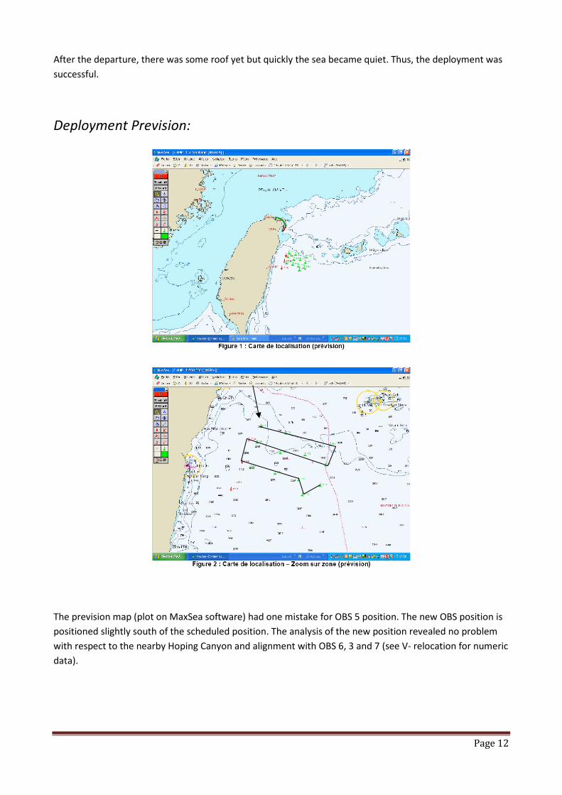
Deployment Prevision:
The prevision map (plot on MaxSea software) had one mistake for OBS 5 position. The new OBS position is
positioned slightly south of the scheduled position. The analysis of the new position revealed no problem
with respect to the nearby Hoping Canyon and alignment with OBS 6, 3 and 7 (see V- relocation for numeric
data).

Page 13
Abstract Logbook (see annexes for details):
The July 19 ------------------------------------------------------------------------------
02h30 (UTC) 10h30 (local time: GMT+8h00): departure from Keelung
11h10: deployment ACTS-P01-I20
12h53:deployment ACTS-P02-I19
15h10: deployment ACTS-P04-I18
16h45: deployment ACTS-P07-I17
18h00: deployment ACTS-P03-I16
19h26: deployment ACTS-P06-I15
20h54: deployment ACTS-P05-I13
21h45: deployment ACTS-P13-MO36 = MicroOBS+ 01
23h27: deployment ACTS-P14-MO26 = MicroOBS+ 02
The July 20 ------------------------------------------------------------------------------
00h07: deployment ACTS-P08-I11
01h14: deployment ACTS-P09-I09
2h25: deployment ACTS-P10-I08
3h20: deployment ACTS-P12-I07
4h23: deployment ACTS-P11-I06
5h50:beginning of the acoustic relocation OBS 12 – I07
07h25: end of the acoustic relocation OBS 12 – I07
08h20: beginning of the acoustic relocation OBS 11 – I06
08h45: end of the acoustic relocation OBS 11 – I06
09h34: beginning of the acoustic relocation OBS 07 – I17
10h05: end of the acoustic relocation OBS 07 – I17
10h48: beginning of the acoustic relocation OBS 04 – I18
11h19: end of the acoustic relocation OBS 04 – I18
12h48: beginning of the acoustic relocation OBS 03 – I16
13h16: end of the acoustic relocation OBS 03 – I16
14h40: beginning of the acoustic relocation OBS 10 – I08
15h09: end of the acoustic relocation OBS 10 – I08
16h04: beginning of the acoustic relocation OBS 09 – I09
16h50: end of the acoustic relocation OBS 09 – I09
17h30: beginning of the acoustic relocation OBS 06 – I15
18h01:end of the acoustic relocation OBS 06 – I15
18h38:beginning of the acoustic relocation OBS 02 – I19
19h14: end of the acoustic relocation OBS 02 – I19
20h20:beginning of the acoustic relocation OBS 01 – I20

Page 14
20h57: end of the acoustic relocation OBS 01 – I20
22h09:beginning of the acoustic relocation OBS 05 – I13
22h45:end of the acoustic relocation OBS 05 – I13
The July 21 ------------------------------------------------------------------------------
02h33: beginning of the acoustic relocation OBS 08 – I11
03h05: end of the acoustic relocation OBS 08 – I11
23h39: beginning acoustic emission on M036 – P13
00h21: end acoustic emission on M036 – P13
01h26: beginning acoustic emission on M026 – P14
02h13: end acoustic emission on M026 – P14
04h54 (12h54 local time):deployment P15 - M019 – MicroOBS+ - coming back to Kaoshiung
12h00 ~: Dolphins animation (30 min)
The July 22 ------------------------------------------------------------------------------
05h00 (local time 13h00): Arrived at Kaoshiung

Page 15
V- OBS deployment location and relocation
The table below shows location for position scheduled, during the deployment and after relocation. To
know more about parameters of relocation process, see after.
Point
on map
OBS N° Position scheduled Position deployment Position Relocation Z (bathy)
P01 20 122.1585 24.2890 2800 24.289 122.1585 2785 24.29236167 122.1600133 2796
P02 19 122.3366 24.2448 1200 24.24456667 122.3361167 1223 24.248575 122.337925 1235
P03 16 122.6625 24.1669 3000 24.10065 122.47885 3022 24.103495 122.4793617 2899
P04 18 122.4791 24.1004 850 24.16666667 122.6623333 832 24.16934667 122.6647417 856
P05 13 122.1285 24.1833 3080 24.157 122.1233333 3183 24.16175 122.12409 3198
P06 15 122.2984 24.1141 2800 24.11413333 122.30005 2834 24.11697833 122.2991283 2846
P07 17 122.6259 24.033 3650 24.03483333 122.626 3661 24.03626833 122.6269083 3696
P08 11 122.0837 24.0191 2950 24.01865 122.0834667 2957 24.022095 122.084785 2986
P09 09 122.2609 23.9794 3150 23.97883333 122.261 3146 23.982325 122.2610767 3194
P10 08 122.43 2 3.9352 3 650 23.93450167 122.4301867 3613 23.93841667 122.4312233 3649
P11 06 122.5885 23.8967 3650 23.89653333 122.5885833 3664 23.89974333 122.5901567 3699
P12 07 122.4583 23.8333 3650 23.83297833 122.4581 3629 23.83655167 122.460235 3664
P13 M036 122.07 24.2 3249 122.0702667 24.19988333 3248 - - -
P14 M026 122.02 24.05 3134 122.0205167 24.05021667 3131 - - -
P15 M019 121.94 23.87 3626 121.9399667 23.86991667 3626 - - -
Point on map OBS Drift Dx (m) Dy (m) Dz (m)
P01 20 Northeastern 153.6 372.4 10.8
P02 19 Northeastern 183.6 444.0 11.6
P03 16 Northeastern 52.1 315.1 -122.7
P04 18 Northeastern 244.8 296.4 24.2
P05 13 Northeastern 76.8 526.0 14.8
P06 15 Northwestern -93.8 315.1 11.8
P07 17 Northeastern 92.4 158.9 34.9
P08 11 Northeastern 134.1 381.5 29.2
P09 09 Northern 7.8 386.7 48.0
P10 08 Northeastern 105.5 433.6 36.1
P11 06 Northeastern 160.2 355.5 34.6
P12 07 Northeastern 217.4 395.8 34.8
The relocation process comes from initial Matlab program written by WAYNE Crawford (IPGP). Acoustic
recording have been done by making Z form 0,5 nautical miles aroundthe deployment location and by ping
emission with 1 minute interval.The program minimizes residual time at all the ping position in a 3D space
window.
Data input, used by the relocation program, are the position of the deployment and all the ping position
with the distance (m) calculated from the double time recording with an average sound speedin the water
of 1525 m.s-1
. It is necessary to input average sound speed in the water based on CTDs during mission, the
sound speed in the water used in the distance calculation, ranges over which the program search and the
wanted resolution. The speed ship was, in average, 5 knots. Thus, the ship covered, with average depth of
3000m, between ping emission and OBS ping back, a distance of about 2m. No CTDs have been done during
our cruise. We used initial mean values for speed water which was given in the program.

Page 16
For the preliminary relocation results we used:
- Ping back position, thus the ship cover ~2m distance between ping emission and ping reception.
Thus, there is a mistake, but negligible, in the calculation of the distance between OBS and the ship.
We have, approximately, the same results with the position of the ping emission. There is a second
mistake, but negligible too, on the position of the acoustic system because the GPS antenna was
not just above the vertical position of it. The outliers are removed.
- Space window with x-y range of 1000m round the initial point and 100m for z range
- Grid resolution of 1m. There are no big differences between relocation results with grid resolution
higher than 1 and smaller than 10.
- Water velocity of 1510 m.s-1
, edge tech Water velocity of 1525m.s-1
and transducer depth of 15m
- Converting latitude/longitude to x/y coordinates in meters by calculating an integrated 6th
order
with approximation to the oblate spheroid
PO1 – OBS 20
PO2 – OBS 19

Page 17
PO3 – OBS 16
PO4 – OBS 18
PO5 – OBS 13
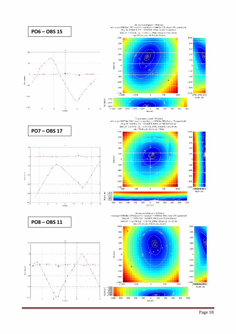
Page 18
PO8 – OBS 11
PO7 – OBS 17
PO6 – OBS 15

Page 19
P11 – OBS 06
P10 – OBS 08
P09 – OBS 09

Page 20
P12 – OBS 07
Page 21
Bibliography
Cattin, R. and J. P. Avouac (2000). "Modeling mountain building and the seismic cycle in the Himalaya of
Nepal." Journal of Geophysical Research105(B6): 13,389-13,407.
Chou, H.-C., B.-Y. Kuo, et al. (2006). "The Taiwan-Ryuku subduction-collision complex; folding of viscoelastic
slab and the double seismic zone." Journal of Geophysical Research111(B4): 14.
Dziewonski, A. M., G. Ekstroem, et al. (1998). "Centroid-moment tensor solutions for October-December,
1997." Physics of the Earth and Planetary Interiors109(3-4): 93-105.
Dziewonski, A. M., G. Ekstrom, et al. (1998). "Centroid-moment tensor solutions for January-March 1997."
Physics of the Earth and Planetary Interiors106(3-4): 171-179.
Dziewonski, A. M., G. Ekstrom, et al. (1998). "Centroid-moment tensor solutions for October-December,
1996." Physics of the Earth and Planetary Interiors105(1-2): 95-108.
Font, Y., H. Kao, et al. (2004). "Hypocentre determination offshore of eastern Taiwan using the maximum
intersection method." Geophysical Journal International158(2): 655-675.
Font, Y. and S. Lallemand (2008). "Subducting oceanic high causes compressional faulting in southernmost
Ryukyu forearc a revealed by hypocentral determinations of earthquakes and reflection/refraction
seismic data." Tectonophysicsin press: 13.
Font, Y., S. Lallemand, et al. (1999). "Etude de la transition entre l'orogene actif de Taiwan et la subduction
des Ryukyu; apport de la sismicite. Transition between the active orogen of Taiwan and the Ryukyu
subduction; a new insight from seismicity." Bulletin de la Societe Geologique de France170(3): 271-
283.
Font, Y., C.-S. Liu, et al. (2001). "Constraints on backstop geometry of the Southwest Ryukyu subduction
based on reflection seismic data." Tectonophysics333(1-2): 135-158.
Hardebeck, J. L., J. J. Nazareth, et al. (1998). "The static stress change triggering model; constraints from
two Southern California aftershock sequences." Journal of Geophysical Research103(B10): 24,427-
24,437.
Lallemand, S. E., Y. Font, et al. (2001). "New insights on 3-D plates interaction near Taiwan from
tomography and tectonic implications." Tectonophysics335(3-4): 229-253.
Loevenbruck, A., R. Cattin, et al. (2004). "Coseismic slip resolution and post-seismic relaxation time of the
1999 Chi-Chi, Taiwan, earthquake as constrained by geological observations, geodetic
measurements and seismicity." Geophysical Journal International158(1): 310-326.
Malavieille, J., S. E. Lallemand, et al. (2002). "Arc-continent collision in Taiwan; new marine observations
and tectonic evolution." Special Paper - Geological Society of America358: 187-211.
Parsons, T. E. and D. S. Dreger (2000). "Static-stress impact of the 1992 Landers earthquake sequence on
nucleation and slip at the site of the 1999 M = 7.1 Hector Mine earthquake, Southern California."
Geophysical Research Letters27(13): 1949-1952.
Sibuet, J.-C. and S.-K. Hsu (2004). "How was Taiwan created?" Tectonophysics379(1-4): 159-181.
Stein, R. S., G. C. King, et al. (1992). "Change in failure stress on the southern San Andreas fault system
caused by the 1992 magnitude = 7.4 Landers earthquake." Science258(5086): 1328-1332.
Wang, T. K., S.-F. Lin, et al. (2004). "Crustal structure of southernmost Ryuktyu subduction zone; OBS, MCS
and gravity modelling." Geophysical Journal International157(1): 147-163.
Wu, Y. M., C.-H. Chang, et al. (2007 (accepted)). "A comprehensive relocation of earthquakes in Taiwan
from 1991 to 2005." Bulletin of the Seismological Society of Americaaccepted.
Yu, S.-B., H.-Y. Chen, et al. (1997). "Velocity field of GPS stations in the Taiwan area." Tectonophysics274(1-
3): 41-59.
Yu, S.-B., L.-C. Kuo, et al. (1999). "GPS observation of crustal deformation in the Taiwan-Luzon region."
Geophysical Research Letters26(7): 923-926.

ANNEXE: LETTERS FROM OUR
PART)
FROM OUR ACTS PROJECT PARTNERS (MARINE
Page 22
ACTS PROJECT PARTNERS (MARINE

Page 23
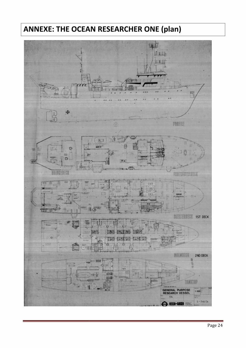
ANNEXE: THE OCEAN THE OCEAN RESEARCHER ONE (plan)
Page 24
(plan)

Page 25
ANNEXE: LOGBOOK ON BOARD

Page 26

Page 27

Page 28

Page 29

Page 30
Page 31

Page 32
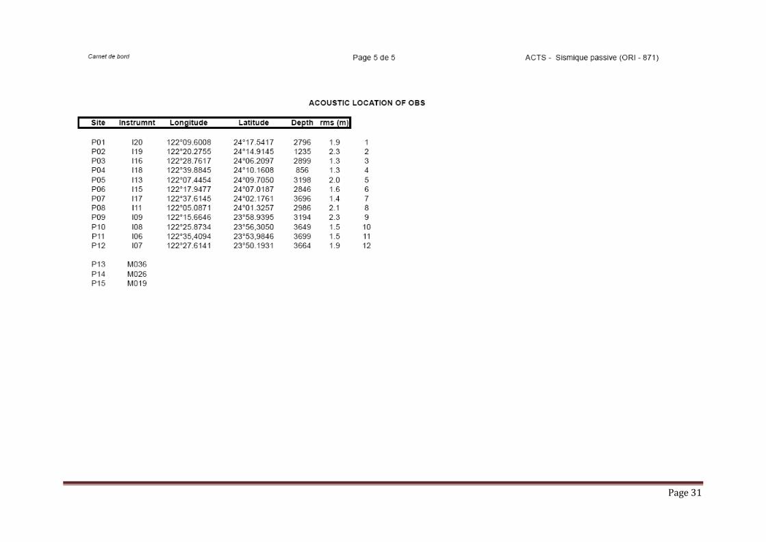
ACOUSTIC DATA
P01 – OBS 20
DATE LAT(°|mn) LON(°|mn) D(m) V (mM/h) DATE LAT LON V(mM/h) 200708202614 2417,6062 12210,0565 2914 008.0 200708202622 2417,6097 12210,0374 008.0 200708202714 2417,6402 12209,9309 2870 005.9 200708202721 2417,6459 12209,9207 005.4
39650 2853 200708202826 2417,689 12209,8459 003.7 200708202914 2417,7012 12209,7993 2844 003.4 200708202921 2417,701 12209,7927 002.7
39650 2832 200708203030 2417,6993 12209,7263 003.8 200708203142 2417,7043 12209,6294 2824 004.9 200708203149 2417,7049 12209,6196 004.7 200708203242 2417,7125 12209,541 2829 005.0 200708203249 2417,7139 12209,5304 004.9 200708203342 2417,7254 12209,4505 2843 005.3 200708203349 2417,7266 12209,4398 005.0 200708203442 2417,7374 12209,359 2864 005.3 200708203449 2417,7387 12209,3483 005.1 200708203542 2417,7485 12209,2672 2894 005.0 200708203550 2417,7504 12209,2549 005.0 200708203642 2417,7439 12209,1933 2917 002.6 200708203650 2417,7381 12209,1929 002.5 200708203742 2417,7111 12209,2601 2882 006.5 200708203749 2417,7078 12209,2735 006.4 200708203842 2417,6738 12209,3468 2850 004.3 200708203849 2417,6689 12209,3538 003.8
39650 2835 200708203956 2417,6134 12209,3898 003.6 39650 2826 200708204052 2417,5446 12209,4146 005.7
200708204142 2417,4721 12209,4431 2823 005.7 200708204149 2417,4626 12209,4476 005.3 200708204242 2417,3909 12209,4796 2829 005.2 200708204249 2417,3819 12209,4843 005.2 200708204342 2417,314 12209,5275 2843 005.4 200708204350 2417,304 12209,5341 005.4 200708204442 2417,2364 12209,576 2867 005.5 200708204449 2417,2274 12209,5815 005.4 200708204542 2417,1586 12209,6203 2901 005.2 200708204550 2417,1484 12209,6265 005.2 200708204642 2417,0825 12209,6707 2943 005.5 200708204650 2417,0725 12209,6773 005.3
39650 3000 200708204755 2416,9899 12209,7307 004.7 200708204842 2416,93 12209,7607 3050 004.7 200708204850 2416,9201 12209,764 004.0 200708205141 2416,9382 12209,5315 3029 005.4 200708205149 2416,9403 12209,5182 005.6 200708205241 2416,9509 12209,4335 3032 005.5 200708205249 2416,9526 12209,4203 005.7 200708205641 2417,0211 12209,0475 3126 005.2 200708205649 2417,0238 12209,0351 005.0 200708205741 2417,0768 12208,9759 3123 007.0 200708205749 2417,0926 12208,976 007.2

Page 33
P02 – 0BS19
DATE LAT(°|mn) LON(°|mn) D(m) V (mM/h) DATE LAT LON V(mM/h) 200708183835 2414,2338 12220,4057 1777 005.4 200708183841 2414,2418 12220,4101 005.2 200708183935 2414,3061 12220,4522 1694 004.5 200708183941 2414,3131 12220,4563 004.7 200708184035 2414,3753 12220,4863 1623 004.3 200708184041 2414,382 12220,4893 004.3 200708184838 2414,8523 12220,7145 1452 004.9 200708184843 2414,8578 12220,7193 005.5 200708184938 2414,8871 12220,7924 1525 003.9 200708184944 2414,8858 12220,7989 003.7 200708185038 2414,8625 12220,8062 1534 002.4 200708185044 2414,859 12220,8044 002.5 200708185138 2414,8127 12220,8113 1548 002.8 200708185144 2414,8079 12220,8095 003.0 200708185238 2414,7703 12220,7744 1520 003.6 200708185244 2414,7666 12220,7692 003.7 200708185338 2414,7388 12220,7115 1473 004.1 200708185344 2414,7361 12220,7039 004.4 200708185438 2414,7142 12220,6315 1420 004.8 200708185443 2414,7121 12220,6245 005.0 200708185538 2414,6926 12220,5466 1374 005.0 200708185543 2414,6916 12220,5397 004.5 200708185638 2414,7147 12220,4505 1315 005.8 200708185643 2414,7175 12220,4422 005.9 200708185738 2414,7264 12220,3569 1284 004.6 200708185743 2414,7253 12220,35 004.5 200708185838 2414,6989 12220,2848 1293 004.3 200708185843 2414,6956 12220,2791 004.4 200708185938 2414,6697 12220,213 1316 004.5 200708185943 2414,6673 12220,2067 004.7
39650 1427 200708190211 2414,5934 12220,0335 004.4 39650 1491 200708190311 2414,5718 12219,9525 004.6
200708190457 2414,5346 12219,8071 1638 004.5 200708190503 2414,5339 12219,7986 004.7 200708190557 2414,5447 12219,7156 1716 005.5 200708190603 2414,5473 12219,706 005.5 200708190657 2414,6033 12219,6473 1735 005.3 200708190703 2414,6123 12219,6456 005.5 200708190757 2414,6883 12219,6569 1673 004.8 200708190803 2414,6961 12219,6596 004.9 200708190857 2414,7585 12219,6926 1606 004.4 200708190903 2414,7648 12219,6962 004.5 200708190957 2414,8204 12219,7304 1549 004.3 200708191003 2414,8267 12219,7337 004.3 200708191057 2414,8789 12219,768 1504 004.1 200708191103 2414,8849 12219,7716 004.0 200708191157 2414,9366 12219,8033 1470 004.1 200708191203 2414,9424 12219,8065 003.9 200708191257 2414,9947 12219,836 1449 003.8 200708191303 2415,0003 12219,8393 003.8 200708191357 2415,0516 12219,868 1437 003.8 200708191402 2415,0562 12219,871 003.9 200708191457 2415,1085 12219,8983 1438 003.8 200708191502 2415,1132 12219,901 003.9

Page 34
P03 – OBS16
DATE LAT(°|mn) LON(°|mn) D(m) V (mM/h) DATE LAT LON V(mM/h)
200708124809 2405,8682 12229,21 3080 004.6 200708124817 2405,8638 12229,2 004.1
200708124909 2405,8243 12229,1456 3071 004.0 200708124917 2405,817 12229,139 004.2
200708125009 2405,7777 12229,0808 3071 004.9 200708125017 2405,7706 12229,0708 005.2
200708125209 2405,6708 12228,9294 3097 005.6 200708125217 2405,663 12228,9187 005.8
200708125309 2405,6128 12228,8518 3125 005.7 200708125317 2405,606 12228,8423 004.7
200708125409 2405,5624 12228,7754 3158 005.2 200708125417 2405,5554 12228,7651 005.4
200708125509 2405,5126 12228,6966 3193 005.4 200708125517 2405,5126 12228,6854 005.0
200708125609 2405,582 12228,6549 3135 007.3 200708125617 2405,5978 12228,6594 007.6
200708125709 2405,7169 12228,6916 3048 008.6 200708125717 2405,7371 12228,6958 009.3
200708125809 2405,866 12228,7244 2977 008.1 200708125817 2405,8842 12228,7285 008.0
200708125909 2405,9829 12228,7521 2939 006.2 200708125917 2405,9959 12228,7553 005.8
200708130009 2406,0684 12228,7745 2922 004.6 200708130017 2406,0782 12228,7768 004.5
200708130109 2406,137 12228,7903 2914 003.9 200708130117 2406,1457 12228,7919 004.0
200708130209 2406,2015 12228,7989 2913 004.1 200708130217 2406,2113 12228,7989 004.6
200708130309 2406,2821 12228,7919 2916 005.0 200708130317 2406,2938 12228,7899 005.3
200708130409 2406,369 12228,7683 2930 005.5 200708130417 2406,3805 12228,7644 005.4
200708130509 2406,459 12228,7432 2952 005.4 200708130517 2406,4711 12228,74 005.6
200708130609 2406,5493 12228,7202 2987 005.3 200708130617 2406,5616 12228,7174 005.6
200708130709 2406,6117 12228,6735 3013 003.3 200708130717 2406,6106 12228,6657 002.9
200708130809 2406,5787 12228,617 3003 004.1 200708130817 2406,5707 12228,612 003.6
200708130909 2406,5138 12228,5732 2984 004.7 200708130917 2406,5044 12228,5668 005.0
200708131009 2406,4512 12228,5144 2978 004.9 200708131017 2406,4431 12228,5056 005.3
200708131109 2406,3918 12228,4538 2980 004.8 200708131117 2406,3844 12228,4462 004.6
200708131209 2406,3359 12228,392 2992 004.9 200708131217 2406,3277 12228,3832 005.1
200708131309 2406,2767 12228,3268 3012 005.4 200708131317 2406,2684 12228,3187 005.3
200708131409 2406,2154 12228,2626 3039 005.2 200708131417 2406,2068 12228,2545 005.4
200708131509 2406,1506 12228,2021 3073 005.5 200708131517 2406,1423 12228,1941 005.1
200708131609 2406,0851 12228,1456 3109 004.5 200708131617 2406,0746 12228,1438 004.5
Page 35
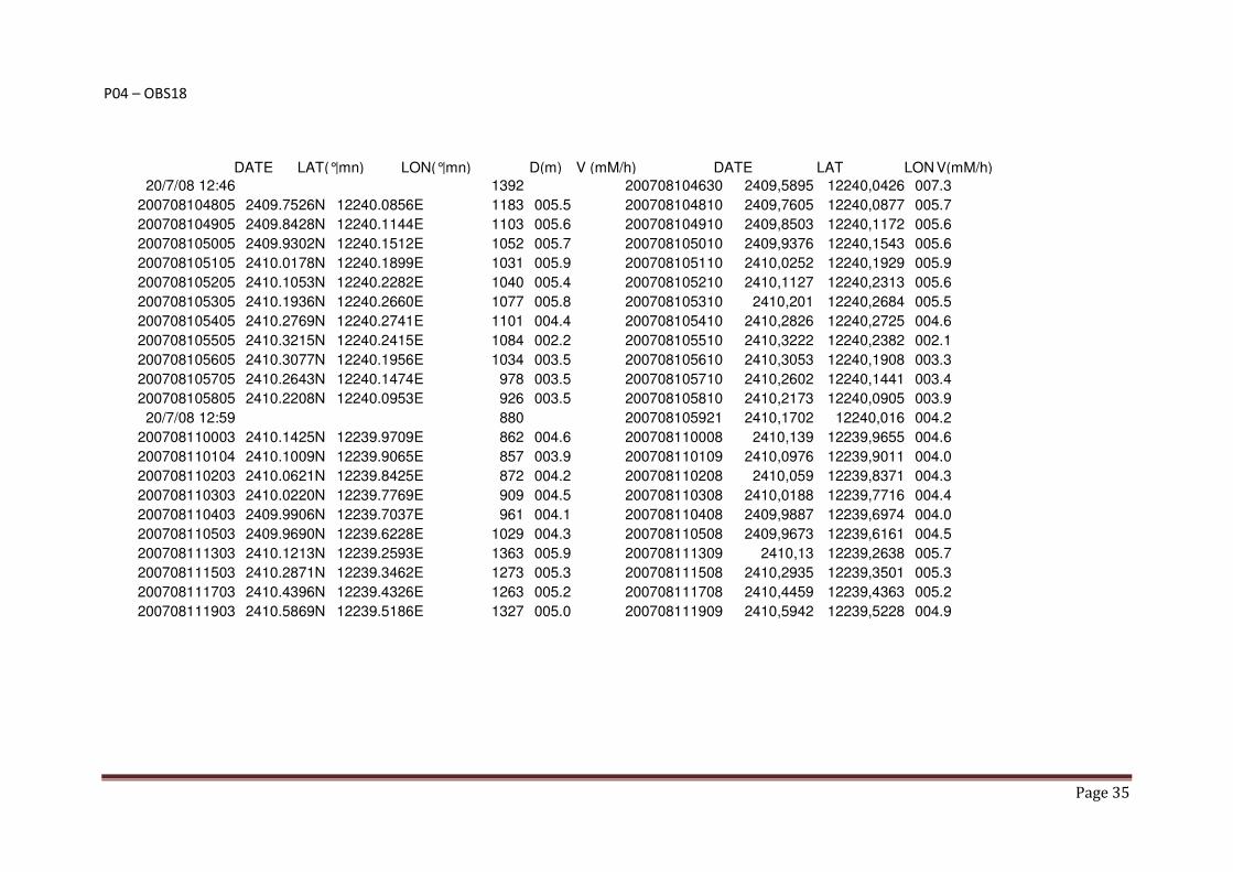
P04 – OBS18
DATE LAT(°|mn) LON(°|mn) D(m) V (mM/h) DATE LAT LON V(mM/h)
20/7/08 12:46 1392 200708104630 2409,5895 12240,0426 007.3
200708104805 2409.7526N 12240.0856E 1183 005.5 200708104810 2409,7605 12240,0877 005.7
200708104905 2409.8428N 12240.1144E 1103 005.6 200708104910 2409,8503 12240,1172 005.6
200708105005 2409.9302N 12240.1512E 1052 005.7 200708105010 2409,9376 12240,1543 005.6
200708105105 2410.0178N 12240.1899E 1031 005.9 200708105110 2410,0252 12240,1929 005.9
200708105205 2410.1053N 12240.2282E 1040 005.4 200708105210 2410,1127 12240,2313 005.6
200708105305 2410.1936N 12240.2660E 1077 005.8 200708105310 2410,201 12240,2684 005.5
200708105405 2410.2769N 12240.2741E 1101 004.4 200708105410 2410,2826 12240,2725 004.6
200708105505 2410.3215N 12240.2415E 1084 002.2 200708105510 2410,3222 12240,2382 002.1
200708105605 2410.3077N 12240.1956E 1034 003.5 200708105610 2410,3053 12240,1908 003.3
200708105705 2410.2643N 12240.1474E 978 003.5 200708105710 2410,2602 12240,1441 003.4
200708105805 2410.2208N 12240.0953E 926 003.5 200708105810 2410,2173 12240,0905 003.9
20/7/08 12:59 880 200708105921 2410,1702 12240,016 004.2
200708110003 2410.1425N 12239.9709E 862 004.6 200708110008 2410,139 12239,9655 004.6
200708110104 2410.1009N 12239.9065E 857 003.9 200708110109 2410,0976 12239,9011 004.0
200708110203 2410.0621N 12239.8425E 872 004.2 200708110208 2410,059 12239,8371 004.3
200708110303 2410.0220N 12239.7769E 909 004.5 200708110308 2410,0188 12239,7716 004.4
200708110403 2409.9906N 12239.7037E 961 004.1 200708110408 2409,9887 12239,6974 004.0
200708110503 2409.9690N 12239.6228E 1029 004.3 200708110508 2409,9673 12239,6161 004.5
200708111303 2410.1213N 12239.2593E 1363 005.9 200708111309 2410,13 12239,2638 005.7
200708111503 2410.2871N 12239.3462E 1273 005.3 200708111508 2410,2935 12239,3501 005.3
200708111703 2410.4396N 12239.4326E 1263 005.2 200708111708 2410,4459 12239,4363 005.2
200708111903 2410.5869N 12239.5186E 1327 005.0 200708111909 2410,5942 12239,5228 004.9
Page 36
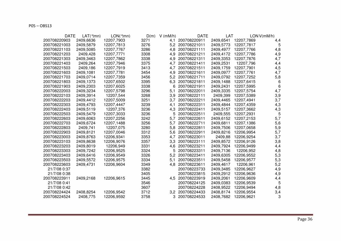
P05 – OBS13
DATE LAT(°|mn) LON(°|mn) D(m) V (mM/h) DATE LAT LON V(mM/h) 200708220903 2409,6636 12207,7903 3271 4,1 200708220911 2409,6541 12207,7869 4,4 200708221003 2409,5879 12207,7813 3276 5,2 200708221011 2409,5773 12207,7817 5 200708221103 2409,5085 12207,7767 3286 4,8 200708221111 2409,4977 12207,7766 4,8 200708221203 2409,428 12207,7771 3308 4,9 200708221211 2409,4172 12207,7786 4,9 200708221303 2409,3463 12207,7862 3338 4,9 200708221311 2409,3353 12207,7876 4,7 200708221403 2409,264 12207,7946 3375 4,7 200708221411 2409,2531 12207,796 4,4 200708221503 2409,186 12207,7919 3413 4,7 200708221511 2409,1759 12207,7901 4,5 200708221603 2409,1081 12207,7781 3454 4,9 200708221611 2409,0977 12207,7761 4,7 200708221703 2409,0714 12207,7359 3456 5,2 200708221711 2409,0792 12207,7252 5,8 200708221803 2409,1373 12207,6502 3395 6,3 200708221811 2409,1488 12207,6415 6 200708221903 2409,2303 12207,6025 3338 6 200708221911 2409,2431 12207,5995 6 200708222003 2409,3234 12207,5798 3296 5,1 200708222011 2409,3335 12207,5754 4,7 200708222103 2409,3914 12207,544 3268 3,9 200708222111 2409,399 12207,5389 3,9 200708222203 2409,4412 12207,5009 3251 3,7 200708222211 2409,4465 12207,4941 3,7 200708222303 2409,4793 12207,4447 3239 4,1 200708222311 2409,4844 12207,4359 4,3 200708222403 2409,5119 12207,376 3236 4,3 200708222411 2409,5157 12207,3662 4,3 200708222503 2409,5479 12207,3033 3236 5 200708222511 2409,555 12207,2931 5 200708222603 2409,6063 12207,2256 3242 5,7 200708222611 2409,6152 12207,2153 5,7 200708222703 2409,6724 12207,1488 3256 5,7 200708222711 2409,6811 12207,1386 5,6 200708222803 2409,741 12207,075 3280 5,8 200708222811 2409,7506 12207,0658 5,9 200708222903 2409,8121 12207,0046 3312 5,6 200708222911 2409,8216 12206,9954 5,7 200708223003 2409,8763 12206,9341 3353 4,7 200708223011 2409,88 12206,9254 3,7 200708223103 2409,8638 12206,9076 3357 3,3 200708223111 2409,8572 12206,9126 3,8 200708223203 2409,8019 12206,949 3331 4,6 200708223211 2409,7924 12206,9499 4,4 200708223303 2409,7242 12206,9525 3324 5 200708223311 2409,7136 12206,952 4,8 200708223403 2409,6416 12206,9549 3326 5,2 200708223411 2409,6305 12206,9552 5,3 200708223503 2409,5572 12206,9575 3334 5,1 200708223511 2409,5458 12206,9577 5,3 200708223603 2409,4731 12206,9604 3349 4,8 200708223611 2409,4617 12206,961 5,2
21/7/08 0:37 3382 200708223733 2409,3485 12206,9627 4,9 21/7/08 0:38 3405 200708223815 2409,2912 12206,9636 4,9
200708223911 2409,2168 12206,9615 3445 4,5 200708223919 2409,2061 12206,9609 4,4 21/7/08 0:41 3546 200708224125 2409,0383 12206,9539 5 21/7/08 0:42 3607 200708224228 2408,9522 12206,9494 4,8
200708224424 2408,8254 12206,9542 3712 3,2 200708224433 2408,8174 12206,9554 3,4 200708224524 2408,775 12206,9592 3758 3 200708224533 2408,7682 12206,9621 3
Page 37
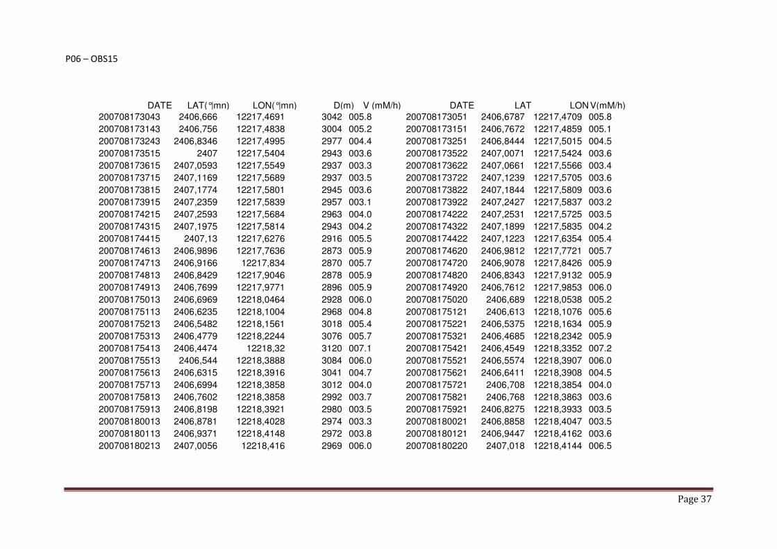
P06 – OBS15
DATE LAT(°|mn) LON(°|mn) D(m) V (mM/h) DATE LAT LON V(mM/h)
200708173043 2406,666 12217,4691 3042 005.8 200708173051 2406,6787 12217,4709 005.8
200708173143 2406,756 12217,4838 3004 005.2 200708173151 2406,7672 12217,4859 005.1
200708173243 2406,8346 12217,4995 2977 004.4 200708173251 2406,8444 12217,5015 004.5
200708173515 2407 12217,5404 2943 003.6 200708173522 2407,0071 12217,5424 003.6
200708173615 2407,0593 12217,5549 2937 003.3 200708173622 2407,0661 12217,5566 003.4
200708173715 2407,1169 12217,5689 2937 003.5 200708173722 2407,1239 12217,5705 003.6
200708173815 2407,1774 12217,5801 2945 003.6 200708173822 2407,1844 12217,5809 003.6
200708173915 2407,2359 12217,5839 2957 003.1 200708173922 2407,2427 12217,5837 003.2
200708174215 2407,2593 12217,5684 2963 004.0 200708174222 2407,2531 12217,5725 003.5
200708174315 2407,1975 12217,5814 2943 004.2 200708174322 2407,1899 12217,5835 004.2
200708174415 2407,13 12217,6276 2916 005.5 200708174422 2407,1223 12217,6354 005.4
200708174613 2406,9896 12217,7636 2873 005.9 200708174620 2406,9812 12217,7721 005.7
200708174713 2406,9166 12217,834 2870 005.7 200708174720 2406,9078 12217,8426 005.9
200708174813 2406,8429 12217,9046 2878 005.9 200708174820 2406,8343 12217,9132 005.9
200708174913 2406,7699 12217,9771 2896 005.9 200708174920 2406,7612 12217,9853 006.0
200708175013 2406,6969 12218,0464 2928 006.0 200708175020 2406,689 12218,0538 005.2
200708175113 2406,6235 12218,1004 2968 004.8 200708175121 2406,613 12218,1076 005.6
200708175213 2406,5482 12218,1561 3018 005.4 200708175221 2406,5375 12218,1634 005.9
200708175313 2406,4779 12218,2244 3076 005.7 200708175321 2406,4685 12218,2342 005.9
200708175413 2406,4474 12218,32 3120 007.1 200708175421 2406,4549 12218,3352 007.2
200708175513 2406,544 12218,3888 3084 006.0 200708175521 2406,5574 12218,3907 006.0
200708175613 2406,6315 12218,3916 3041 004.7 200708175621 2406,6411 12218,3908 004.5
200708175713 2406,6994 12218,3858 3012 004.0 200708175721 2406,708 12218,3854 004.0
200708175813 2406,7602 12218,3858 2992 003.7 200708175821 2406,768 12218,3863 003.6
200708175913 2406,8198 12218,3921 2980 003.5 200708175921 2406,8275 12218,3933 003.5
200708180013 2406,8781 12218,4028 2974 003.3 200708180021 2406,8858 12218,4047 003.5
200708180113 2406,9371 12218,4148 2972 003.8 200708180121 2406,9447 12218,4162 003.6
200708180213 2407,0056 12218,416 2969 006.0 200708180220 2407,018 12218,4144 006.5

Page 38
P07 – OBS17
DATE LAT(°|mn) LON(°|mn) D(m) V (mM/h) DATE LAT LON V(mM/h) 200708093346 2401.6599N 12237.0545E 3951 006.3 200708093355 2401,6756 12237,0584 006.4 200708093446 2401.7602N 12237.0824E 3899 006.0 200708093455 2401,775 12237,0865 006.0 200708093546 2401.8578N 12237.1102E 3857 006.0 200708093555 2401,8725 12237,1136 006.2 200708093646 2401.9546N 12237.1316E 3828 006.0 200708093655 2401,9693 12237,1351 006.1 200708093746 2402.0525N 12237.1517E 3805 006.0 200708093755 2402,0673 12237,1547 006.1 200708093846 2402.1504N 12237.1686E 3794 006.0 200708093855 2402,1651 12237,1704 005.8 200708093946 2402.2487N 12237.1837E 3793 006.3 200708093955 2402,2633 12237,1855 005.9 200708094046 2402.3463N 12237.1988E 3800 005.9 200708094055 2402,361 12237,2012 006.0 200708094146 2402.4384N 12237.2203E 3811 005.2 200708094155 2402,4494 12237,2277 005.1 200708094246 2402.4861N 12237.2813E 3805 003.6 200708094255 2402,4886 12237,2908 003.6 200708094346 2402.4864N 12237.3365E 3790 002.9 200708094355 2402,483 12237,3422 003.0 200708094446 2402.4530N 12237.3729E 3773 003.1 200708094455 2402,4463 12237,3789 003.2 200708094546 2402.4063N 12237.4031E 3758 003.1 200708094555 2402,3979 12237,4059 003.9 200708094646 2402.3407N 12237.4209E 3744 004.0 200708094655 2402,3295 12237,4231 004.9 200708094746 2402.2678N 12237.4411E 3732 004.3 200708094755 2402,2567 12237,445 005.0 200708094846 2402.1897N 12237.4666E 3724 005.0 200708094855 2402,1773 12237,4711 005.2 200708094946 2402.1100N 12237.4944E 3724 005.3 200708094955 2402,0979 12237,4978 004.8 200708095046 2402.0272N 12237.5223E 3730 005.4 200708095055 2402,0147 12237,5261 005.1 200708095146 2401.9446N 12237.5662E 3744 005.9 200708095155 2401,9325 12237,5741 006.2 200708095246 2401.8663N 12237.6139E 3764 005.2 200708095255 2401,8551 12237,6212 004.3 20/7/08 11:54 3794 200708095405 2401,7658 12237,6721 005.0
200708095601 2401.6100N 12237.7637E 3877 005.6 200708095610 2401,5988 12237,7712 005.3 200708095701 2401.5381N 12237.8155E 3922 005.4 200708095710 2401,5335 12237,829 005.4 200708095801 2401.5671N 12237.9045E 3915 005.9 200708095810 2401,5813 12237,9107 006.1 200708095901 2401.6747N 12237.9196E 3864 006.8 200708095910 2401,6911 12237,9207 006.6 200708100001 2401.7795N 12237.9318E 3826 006.0 200708100010 2401,7942 12237,934 005.8 200708100101 2401.8730N 12237.9470E 3802 005.5 200708100110 2401,8862 12237,9489 005.2 200708100201 2401.9603N 12237.9599E 3785 005.2 200708100210 2401,9731 12237,9619 005.3 200708100301 2402.0447N 12237.9714E 3774 005.2 200708100310 2402,0571 12237,9729 005.1 200708100401 2402.1281N 12237.9803E 3771 004.9 200708100410 2402,1407 12237,9815 004.8 200708100501 2402.2111N 12237.9891E 3774 004.8 200708100510 2402,2237 12237,9906 005.1 200708100601 2402.2942N 12237.9970E 3784 004.9 200708100610 2402,3067 12237,9983 005.1

Page 39
P08 – OBS11
DATE LAT(°|mn) LON(°|mn) D(m) V (mM/h) DATE LAT LON V(mM/h) 210708023322 2401,5745 12204,4989 3192 8,6 210708023330 2401,5681 12204,5186 8,7 210708023422 2401,5243 12204,6449 3111 8,3 210708023430 2401,518 12204,6648 8,7 210708023522 2401,4801 12204,7793 3055 6,9 210708023530 2401,4747 12204,7932 5,9 210708023623 2401,4232 12204,7833 3050 4,6 210708023631 2401,4143 12204,7762 5 210708023722 2401,3507 12204,7385 3059 5,4 210708023730 2401,3399 12204,7352 5,2 210708023822 2401,2697 12204,7052 3074 5,5 210708023830 2401,2589 12204,6995 5,5 210708023922 2401,1891 12204,6652 3099 5,2 210708023930 2401,1783 12204,6592 5,5 210708024022 2401,1079 12204,624 3134 5,5 210708024030 2401,0972 12204,6181 5,3 210708024122 2401,0266 12204,5824 3177 5,4 210708024130 2401,0158 12204,5765 5,3 210708024222 2400,9456 12204,5402 3228 5,4 210708024230 2400,9348 12204,5346 5,5 210708024322 2400,8649 12204,4997 3288 5 210708024330 2400,854 12204,4937 5,2 210708024452 2400,8645 12204,5855 3231 7,9 210708024500 2400,8788 12204,5975 8,2 210708024552 2400,9676 12204,6766 3148 6,7 210708024600 2400,978 12204,6877 6,4 210708024652 2401,0326 12204,7532 3099 5 210708024700 2401,039 12204,7621 4,9 210708024752 2401,0804 12204,8197 3065 4,5 210708024800 2401,0865 12204,8287 4,6 210708024951 2401,1487 12204,9677 3024 4,9 210708024959 2401,1517 12204,9787 4,8 210708025051 2401,1662 12205,0541 3013 5,2 210708025059 2401,168 12205,0658 5 210708025151 2401,1909 12205,1449 3010 5,8 210708025159 2401,1972 12205,1573 5,7 210708025251 2401,239 12205,2358 3015 5,3 210708025259 2401,2447 12205,2473 5,4 210708025351 2401,2786 12205,3216 3030 5,1 210708025359 2401,284 12205,3331 5,4 210708025451 2401,3174 12205,4067 3052 5,1 210708025459 2401,3227 12205,4181 5,2 210708025710 2401,3968 12205,5994 3132 3,3 210708025718 2401,3938 12205,6061 2,9 210708025810 2401,3621 12205,5812 3117 4,2 210708025818 2401,3554 12205,573 4,5 210708025910 2401,2963 12205,5342 3097 5 210708025918 2401,2864 12205,5294 4,9 210708030010 2401,2201 12205,4911 3087 5,2 210708030018 2401,2097 12205,4856 5,2 210708030110 2401,1416 12205,4485 3085 5 210708030118 2401,1307 12205,4459 5,1 210708030210 2401,0596 12205,4313 3100 4,8 210708030218 2401,0484 12205,4294 5 210708030310 2400,9764 12205,4135 3126 5,1 210708030318 2400,9653 12205,4115 5,1 210708030410 2400,8941 12205,3876 3154 5,4 210708030418 2400,8836 12205,3828 5,3 210708030510 2400,8137 12205,3544 3187 5,5 210708030518 2400,8029 12205,3492 5,4

Page 40
P09 – OBS09
DATE LAT(°|mn) LON(°|mn) D(m) V (mM/h) DATE LAT LON V(mM/h) 200708160426 2358,1402 12216,6375 3901 007.9 200708160435 2358,1482 12216,6184 007.6 200708160526 2358,1972 12216,528 3785 006.1 200708160535 2358,205 12216,5139 005.7 200708160626 2358,2568 12216,4399 3689 006.1 200708160635 2358,2658 12216,4271 005.8 200708160726 2358,3141 12216,3566 3605 005.5 200708160734 2358,322 12216,3456 005.6 200708160826 2358,3753 12216,2771 3527 005.4 200708160834 2358,3829 12216,2661 005.8 200708160926 2358,4188 12216,1956 3466 004.9 200708160934 2358,4233 12216,1849 004.7 200708161026 2358,4368 12216,121 3428 003.9 200708161034 2358,4377 12216,1116 003.8 200708161126 2358,4494 12216,0484 3396 004.0 200708161134 2358,4518 12216,0385 004.3 200708161226 2358,4512 12215,9846 3378 003.0 200708161234 2358,4498 12215,9773 003.1 200708161326 2358,4437 12215,9282 3366 003.6 200708161334 2358,4449 12215,9193 003.7 200708161426 2358,4522 12215,8614 3349 003.5 200708161434 2358,4534 12215,8514 003.9 200708161526 2358,4603 12215,7846 3337 004.6 200708161534 2358,4613 12215,7739 004.5 200708161626 2358,4683 12215,706 3326 004.6 200708161634 2358,4693 12215,6958 004.2 200708161726 2358,477 12215,6275 3323 003.9 200708161734 2358,4782 12215,6171 004.5 200708161826 2358,4731 12215,5587 3331 003.4 200708161834 2358,4719 12215,5493 003.6 200708161926 2358,4633 12215,4859 3346 004.4 200708161934 2358,4616 12215,4757 004.0 200708162127 2358,4419 12215,3199 3399 004.8 200708162135 2358,4416 12215,3079 005.1 200708162226 2358,4374 12215,2325 3434 005.0 200708162234 2358,4365 12215,2205 004.9 200708162626 2358,7047 12215,2289 3324 004.5 200708162634 2358,7123 12215,2358 004.2 200708162726 2358,7597 12215,2809 3289 004.1 200708162734 2358,7669 12215,2882 004.3 200708162826 2358,8096 12215,3367 3265 004.2 200708162834 2358,8163 12215,3442 004.3 200708162926 2358,8584 12215,3932 3245 004.3 200708162934 2358,8649 12215,401 004.2 200708163026 2358,9073 12215,4512 3230 004.3 200708163034 2358,9138 12215,4587 004.2 200708163126 2358,9503 12215,5083 3219 003.8 200708163134 2358,9553 12215,516 003.4 200708163226 2358,9846 12215,5648 3215 003.8 200708163234 2358,988 12215,5733 003.8 200708163326 2359,0044 12215,6352 3212 004.2 200708163334 2359,0059 12215,6458 004.2 200708163426 2359,0141 12215,7165 3213 004.7 200708163434 2359,0149 12215,7278 004.8 200708163526 2359,0221 12215,8011 3222 004.7 200708163534 2359,023 12215,8124 004.8 200708163626 2359,0317 12215,8854 3238 004.6 200708163634 2359,0342 12215,8973 004.8 200708163726 2359,0519 12215,9748 3264 005.1 200708163734 2359,0548 12215,9869 005.2 200708163826 2359,0687 12216,0711 3297 010.1 200708163834 2359,0682 12216,0883 006.2 200708163926 2359,1575 12216,1416 3340 007.2 200708163934 2359,1739 12216,1405 007.1 200708164026 2359,2362 12216,0875 3335 004.0 200708164034 2359,2361 12216,0784 003.7 200708164126 2359,216 12216,0155 3305 004.9 200708164134 2359,2131 12216,0041 005.2 200708164226 2359,1949 12215,9219 3273 005.6 200708164234 2359,1918 12215,9092 005.7 200708164326 2359,1714 12215,8226 3250 005.7 200708164334 2359,1684 12215,81 005.1 200708164426 2359,1516 12215,7302 3236 004.8 200708164434 2359,1488 12215,7189 005.2 200708164526 2359,1299 12215,6448 3230 004.8 200708164534 2359,1269 12215,6332 004.9 200708164626 2359,1078 12215,5596 3233 004.8 200708164634 2359,1054 12215,548 005.1 200708164726 2359,0864 12215,4733 3242 004.8 200708164734 2359,0834 12215,4617 004.9 200708164826 2359,0665 12215,3866 3257 005.1 200708164834 2359,0635 12215,3756 004.8 200708164926 2359,0466 12215,3017 3283 004.5 200708164934 2359,0439 12215,2904 004.7 200708165026 2359,0302 12215,2154 3312 005.4 200708165034 2359,0286 12215,2039 004.8

Page 41
P10 – OBS08
DATE LAT(°|mn) LON(°|mn) D(m) V (mM/h) DATE LAT LON V(mM/h) 200708144002 2356,2273 12226,2226 3721 005.4 200708144011 2356,2136 12226,2207 005.2 200708144202 2356,0473 12226,1931 3744 005.5 200708144211 2356,0336 12226,1908 005.6 200708144302 2355,9578 12226,1775 3770 005.1 200708144311 2355,9439 12226,1755 005.7 200708144502 2355,7802 12226,1395 3829 005.5 200708144511 2355,7672 12226,1362 005.1 200708144702 2355,6738 12226,0493 3863 005.4 200708144711 2355,6815 12226,0372 005.3 200708144802 2355,7575 12225,9899 3809 006.3 200708144811 2355,7719 12225,9844 006.2 200708144902 2355,8554 12225,9563 3764 005.8 200708144911 2355,8681 12225,9501 005.7 200708145002 2355,9353 12225,9116 3730 005.5 200708145011 2355,9473 12225,9056 005.3 200708145102 2356,0153 12225,8697 3707 005.3 200708145111 2356,0269 12225,8627 005.2 20/7/08 16:53 3686 200708145311 2356,1575 12225,7495 005.2
200708145358 2356,2078 12225,6974 3686 005.5 200708145407 2356,2175 12225,6873 005.6 200708145458 2356,2719 12225,6287 3695 005.3 200708145507 2356,2817 12225,6185 005.7 200708145558 2356,3372 12225,5589 3712 005.6 200708145607 2356,3465 12225,5485 005.5 20/7/08 16:57 3739 200708145711 2356,417 12225,4749 005.5
200708145806 2356,481 12225,4152 3773 005.7 200708145815 2356,4923 12225,4061 005.3 200708145906 2356,5567 12225,3558 3811 005.5 200708145915 2356,568 12225,3468 005.5 200708150006 2356,5954 12225,2894 3846 003.8 200708150015 2356,5915 12225,2806 003.2 200708150106 2356,5385 12225,275 3835 005.0 200708150115 2356,5261 12225,2768 004.9 200708150206 2356,4493 12225,2869 3814 005.6 200708150215 2356,4353 12225,2886 006.0 200708150306 2356,3549 12225,2907 3805 005.5 200708150315 2356,3407 12225,2914 005.5 200708150406 2356,2609 12225,2938 3803 005.8 200708150415 2356,2467 12225,2942 005.5 200708150506 2356,1636 12225,2968 3811 006.3 200708150515 2356,1496 12225,2977 005.6 200708150606 2356,0733 12225,3013 3826 005.8 200708150615 2356,0591 12225,3021 005.9 200708150706 2355,9772 12225,3059 3848 005.6 200708150715 2355,9624 12225,3065 005.8 200708150906 2355,7859 12225,3128 3921 005.4 200708150915 2355,7721 12225,3132 005.2

Page 42
P11 – OBS06
DATE LAT(°|mn) LON(°|mn) D(m) V (mM/h) DATE LAT LON V(mM/h) 200708081846 2353,3732 12235,4691 3890 006.5 200708081855 2353,3837 12235,4823 006.5 200708081946 2353,4407 12235,5527 3861 005.5 200708081955 2353,4504 12235,5643 005.5 200708082046 2353,5016 12235,6277 3845 005.0 200708082055 2353,5103 12235,6386 005.2 200708082146 2353,554 12235,7013 3838 005.2 200708082155 2353,5612 12235,7123 005.0 200708082246 2353,6029 12235,7729 3840 004.9 200708082255 2353,61 12235,7843 005.2 200708082346 2353,6598 12235,8304 3835 004.2 200708082355 2353,6694 12235,8337 003.8 200708082446 2353,7145 12235,8258 3819 002.5 200708082455 2353,7199 12235,821 002.9 200708082546 2353,7357 12235,7699 3797 004.6 200708082555 2353,7395 12235,7567 005.6 200708082646 2353,7484 12235,6756 3771 005.5 200708082655 2353,7516 12235,6604 005.4 200708082746 2353,7649 12235,5788 3752 005.1 200708082755 2353,7673 12235,5653 004.6 200708082846 2353,779 12235,4888 3742 005.2 200708082855 2353,7816 12235,4759 005.2 200708082946 2353,7913 12235,402 3736 004.9 200708082955 2353,7928 12235,3892 004.8 200708083046 2353,7988 12235,3191 3738 004.5 200708083055 2353,8001 12235,3066 004.4 200708083146 2353,8171 12235,2407 3744 004.5 200708083155 2353,8237 12235,2298 004.5 200708083246 2353,8545 12235,1581 3755 005.6 200708083255 2353,8578 12235,145 005.3 200708083346 2353,8738 12235,0682 3773 005.6 200708083355 2353,8775 12235,0546 005.3 200708083446 2353,9015 12234,9767 3799 005.9 200708083455 2353,9051 12234,9628 005.4 200708083546 2353,9255 12234,8827 3834 005.3 200708083555 2353,9293 12234,8687 005.6 200708083646 2353,949 12234,7888 3875 005.4 200708083655 2353,9533 12234,7743 006.0 200708083746 2353,9875 12234,7072 3913 004.9 200708083755 2353,9999 12234,7034 005.0 200708083846 2354,0599 12234,75 3887 006.0 200708083855 2354,0674 12234,7645 006.1 200708083946 2354,1044 12234,8474 3848 005.7 200708083955 2354,1108 12234,8613 005.6 200708084046 2354,1403 12234,9372 3816 005.2 200708084055 2354,1451 12234,9494 004.7 200708084146 2354,1709 12235,0192 3793 004.9 200708084155 2354,1754 12235,032 004.9 200708084246 2354,2025 12235,106 3777 005.0 200708084255 2354,2072 12235,1193 005.0 200708084346 2354,235 12235,1946 3767 005.2 200708084355 2354,2396 12235,2083 005.5 200708084446 2354,2682 12235,2842 3765 004.9 200708084455 2354,2735 12235,2973 004.7 200708084546 2354,3001 12235,3719 3770 004.9 200708084555 2354,3051 12235,3851 005.1

Page 43
P12 – OBS07
DATE LAT(°|mn) LON(°|mn) D(m) V (mM/h) DATE LAT LON V(mM/h) 200708064837 2350,1229 12227,5143 3689 003.0 200708064846 2350.1174N 12227.5193E 003.0 200708064737 2350,1585 12227,4808 3690 002.9 200708064746 2350.1535N 12227.4858E 002.9 200708064937 2350,0852 12227,5457 3690 002.7 200708064946 2350.0795N 12227.5489E 002.6 200708064637 2350,1894 12227,447 3694 002.2 200708064646 2350.1854N 12227.4519E 002.2 200708065037 2350,0535 12227,5602 3694 001.5 200708065046 2350.0500N 12227.5602E 001.6 200708064537 2350,2098 12227,4195 3698 002.0 200708064546 2350.2075N 12227.4244E 001.9 200708065237 2350,0148 12227,5484 3700 001.3 200708065246 2350.0117N 12227.5471E 001.4 200708065337 2349,996 12227,535 3703 001.8 200708065346 2349.9939N 12227.5318E 001.5 200708064437 2350,2271 12227,3806 3704 001.9 200708064446 2350.2245N 12227.3865E 001.9 200708065537 2349,9805 12227,502 3709 001.0 200708065546 2349.9788N 12227.5031E 001.2 200708065637 2349,9667 12227,5191 3710 001.6 200708065646 2349.9642N 12227.5233E 001.9 200708064337 2350,2422 12227,342 3712 002.6 200708064346 2350.2400N 12227.3483E 002.4 200708064237 2350,2583 12227,2994 3723 002.7 200708064246 2350.2561N 12227.3068E 003.0 200708064137 2350,2729 12227,247 3739 003.2 200708064146 2350.2707N 12227.2549E 002.8 200708064037 2350,2832 12227,1879 3756 003.8 200708064046 2350.2816N 12227.1967E 003.4 200708063937 2350,2899 12227,1262 3779 003.1 200708063946 2350.2894N 12227.1358E 003.3 200708063837 2350,2883 12227,0602 3806 003.9 200708063846 2350.2896N 12227.0704E 004.0 200708063737 2350,2806 12226,9946 3834 003.9 200708063746 2350.2818N 12227.0039E 003.3 200708063637 2350,2666 12226,9351 3863 003.1 200708063646 2350.2703N 12226.9433E 003.7 200708061830 2349,6678 12227,1939 3880 003.0 200708061839 2349.6726N 12227.1873E 003.1 200708061930 2349,6966 12227,1524 3880 003.0 200708061939 2349.7011N 12227.1461E 003.0 200708061730 2349,6315 12227,2361 3881 003.0 200708061739 2349.6383N 12227.2303E 003.3 200708063537 2350,2383 12226,8887 3886 002.8 200708063546 2350.2421N 12226.8954E 002.9 200708061630 2349,5866 12227,2752 3895 003.6 200708061639 2349.5927N 12227.2690E 003.2 200708063437 2350,2061 12226,8512 3910 002.7 200708063446 2350.2115N 12226.8566E 002.9 200708063337 2350,1695 12226,822 3925 002.4 200708063346 2350.1749N 12226.8260E 002.4 200708061430 2349,496 12227,3463 3934 002.8 200708061439 2349.5030N 12227.3416E 003.5 200708063237 2350,1358 12226,798 3944 002.1 200708063246 2350.1412N 12226.8018E 002.7 200708062637 2349,9163 12226,8492 3947 003.2 200708062646 2349.9213N 12226.8426E 002.9 200708061330 2349,4554 12227,3746 3951 003.7 200708061339 2349.4609N 12227.3704E 002.4 200708063137 2350,1023 12226,7802 3959 002.4 200708063146 2350.1070N 12226.7822E 002.0 200708062737 2349,9481 12226,8029 3967 003.4 200708062746 2349.9526N 12226.7961E 002.9 200708063037 2350,067 12226,7683 3968 002.3 200708063046 2350.0722N 12226.7694E 002.1 200708062937 2350,0281 12226,7618 3977 002.7 200708062946 2350.0340N 12226.7621E 002.3 200708062837 2349,9838 12226,7667 3982 002.9 200708062846 2349.9904N 12226.7645E 002.9 200708061025 2349,3192 12227,4337 4037 002.6 200708061034 2349.3258N 12227.4324E 002.6 200708053518 2349,3389 12227,8375 4040 004.1 200708053527 2349.3318N 12227.8297E 004.0 200708053718 2349,264 12227,7477 4085 003.6 200708053727 2349.2577N 12227.7403E 004.1 200708054125 2349,0967 12227,542 4223 003.3 200708054135 2349.0909N 12227.5346E 002.7 200708060325 2349,0561 12227,2805 4282 003.0 200708060335 2349.0626N 12227.2852E 002.6 200708054325 2349,0162 12227,4475 4305 003.9 200708054335 2349.0089N 12227.4388E 003.9 200708060125 2348,9741 12227,22 4377 003.2 200708060135 2348.9813N 12227.2247E 002.9 200708060025 2348,9283 12227,1874 4430 003.4 200708060035 2348.9364N 12227.1930E 003.3

Page 44
ANNEXE: ENGINEERS INFORMATIONS

Page 45

Page 46

Page 47