Simplifying, Multiplying, & Rationalizing Radicals Homework: Radical Worksheet.
RATIONALIZING PUBLIC
TRANSPORT: A EURO-ASIAN
PERSPECTIVE
MAHER NIGER
June, 2011
SUPERVISORS:
Dr. Ir. M.H.P. Zuidgeest Ing. F.H.M. van den Bosch

Thesis submitted to the Faculty of Geo-Information Science and Earth
Observation of the University of Twente in partial fulfilment of the
requirements for the degree of Master of Science in Geo-information Science
and Earth Observation.
Specialization: Urban planning and management
SUPERVISORS:
Dr. Ir. M.H.P. Zuidgeest Ing. F.H.M. van den Bosch
THESIS ASSESSMENT BOARD:
Prof.Dr.Ir. M.F.A.M. van Maarseveen (Chairman)
Ir. Pieter Onderwater (External examiner; SSI, Durban, South Africa)
RATIONALIZING PUBLIC
TRANSPORT: A EURO-ASIAN
PERSPECTIVE
MAHER NIGER
Enschede, the Netherlands, [June, 2011]

DISCLAIMER
This document describes work undertaken as part of a programme of study at the Faculty of Geo-Information Science and
Earth Observation of the University of Twente. All views and opinions expressed therein remain the sole responsibility of the
author, and do not necessarily represent those of the Faculty.
i
ABSTRACT
Public transport plays an important role in providing easy and affordable accessibility and mobility for
dwellers in a city. Connecting people and goods from one point to the other, cities connectivity within and
with other cities is directly relative to the economic, social and cultural success to its urban growth. The
efficiency of the public transport infrastructure is higher in areas with a higher demand for such
transportation, which in return is economically viable to its high investment. However when the demand
exceeds the supply level (e.g. capacity) of this public transport infrastructure, they tend to reduce in their
efficiency. This demand for transportation is brought about by the increased population of connecting
nodes, cities, the rural-urban migration, and the scope for socio-economical facilities i.e. better
opportunities for jobs, health facilities and educational scope etc. thus the economic viability of the people
which leads to an increase in the usage of private vehicles. In an over densely populated city like Dhaka,
rationalizing public transport is the only option to minimize the mismatch between demand and supply.
The main goal of this research is to study rationalization of public transport, particularly public transport
system design (routes and their categorization) in Dhaka, Bangladesh, based on European public transport
planning tradition and best practices. The study comprises of three consecutive phases. In the first phase
the problem analysis is performed through literature review and study area inventory with respect to road
network, existing bus routes, their hierarchy, bus stops, population data, terminal and organizations etc.
The second phase studies public transportation planning theory and rationalization concept in public bus
route network planning using the literature base and European best practices. A theoretical framework of
rationalization is established, which is accordingly implemented in the context of the study area. Finally, a
proposal regarding bus network improvement for Dhaka has been prepared based on EU experience in
the rationalization of public transport and recommendations made on public transportation planning and
policies.
As the study progresses, the findings suggests five main components are closely associated for
rationalizing public transport; network, system planning, institutional framework, organization and
finance. The framework is interdependent on components and sub-components: hierarchy, dedicated bus
route, terminal location, service provision, special planning, demand analysis, infrastructure, public-private
relationship, government role, fare structure, policies, service integration, subsidies and management of
public transport; share the relative success and failure depending different level of performances of the
components. For implementation of this framework in Dhaka, specific guiding objectives rules needs to
be considered. Objectives includes; reduce congestion and delays on the transport network, develop an
efficient public transport system, strengthen institutional policy and regulatory framework, prepare long-
term urban transport plan with future growth forecast, service to future land-use planning for the capital
area, and improve road safety and environment sustainability.
The findings of this research help planners and decision makers to optimize the investment in transport infrastructure. Furthermore it set an example on the investigation of theory and practice of rationalizing public transport.
Keywords: Rationalization, Public transport planning and policies, Transport network, Theoretical
framework, Route hierarchy and mass rapid transit.
ii
ACKNOWLEDGEMENTS
Firstly, I would like to express my appreciation to both my supervisors Dr. Ir. M.H.P. Zuidgeest and Ing.
F.H.M. van den Bosch for their most valued inspiration and affectionate guidance at all level of the
research. Their advices and prudence has carried me pass every level of challenges. It is indeed for their
supervision that has always been my strength and encouragement to nurture new ideas of problem
solving. It would have been impossible to carry out this study without their dynamic direction under a
number of constraints and time limitations in particular.
I am grateful to the European Union for the financial support towards the pursuit of my study. I also
acknowledge the support of Mr. Pieter Onderwater, a public transport consultant working at DHV; Mr.
Guido Bruggeman, a freelance public transport consultant who previously worked with European Bank of
Reconstruction and Development (EBRD); Mr. Arjan Vermeulen, HTM, the public transport operator in
Den Hague, The Netherlands, for their cooperation regarding interviews and Mr. Boris Buffing from
Almere municipality for his valuable time during my field visit.
I extend special appreciation to my Course director Monika Kuffer for valuable guidance and kind
assistance in all my difficult times during the whole study period. I also thankful to all the staff and
personnel of the department of Urban Planning & Management (UPM) of Faculty of ITC, University of
Twente, The Netherlands, for their heart worthy support and kind co-operation. I cannot forget to
acknowledge Ms. Laura Windig for her friendly and professional approach in handling administrative
issues that are of relevance to students.
This acknowledgement cannot be complete without mentioning my classmates (UPM 2009-2011), the
friends I made from different continents. My acknowledgement goes particularly to Rian Wulan Desriani,
Mathenge Mwehe, Frinaldi Frinaldi and Richard Hsieh, your critical comments and advice are a great value
in this research.
Finally, I would like to express my heartiest thanks to my beloved husband, Zamshed Uddin Ahmed. I
always believe that without his inspiration, encouragement and accompany to complete my masters
program at ITC was not possible at all. His continuous support and assistance for different information
regarding my study was extraordinary. I am very much proud to have my affectionate son, Ahmed
Zuhayer Aariz and daughter Unaysah Nyasia Inaaya with me in Netherlands to accompany me during my
study period which gave me extra comfort to complete my research successfully.
I give special thanks to my beloved parents, brother, sister and the entire family for their moral support,
encouragement and prayers;
My ultimate gratitude goes to Almighty Allah.
Maher Niger
Enschede, June 2011

iii
TABLE OF CONTENTS
Abstract ............................................................................................................................................................................ i
Acknowledgements ....................................................................................................................................................... ii
Table of contents .......................................................................................................................................................... iii
List of figures.................................................................................................................................................................. v
List of tables .................................................................................................................................................................. vi
List of Maps .................................................................................................................................................................. vii
Acronyms .....................................................................................................................................................................viii
1. Introduction ........................................................................................................................................................... 1
1.1. General introduction...................................................................................................................................................1 1.2. Background of research ..............................................................................................................................................1 1.3. Justification ...................................................................................................................................................................2 1.4. Research problem ........................................................................................................................................................3 1.5. Research objectives and questions ...........................................................................................................................4 1.5.1. Research objectives .....................................................................................................................................................4 1.5.2. Research questions ......................................................................................................................................................4 1.6. Conceptual framework ...............................................................................................................................................6 1.7. Thesis structure ............................................................................................................................................................6
2. Methodology .......................................................................................................................................................... 9
2.1. Research methodology ...............................................................................................................................................9 2.2. Research design matrix ............................................................................................................................................ 11 2.3. Primary data collection ............................................................................................................................................ 11 2.4. Secondary data collection ........................................................................................................................................ 13 2.5. Data processing......................................................................................................................................................... 13 2.5.1. Primary dataset .......................................................................................................................................................... 13 2.5.2. Secondary dataset ..................................................................................................................................................... 13 2.6. Conclusion ................................................................................................................................................................. 14
3. Spatial configuration and transport in Dhaka ................................................................................................15
3.1. Background of the study area: Dhaka city ........................................................................................................... 15 3.2. Land use pattern ....................................................................................................................................................... 16 3.3. Population growth trend and density.................................................................................................................... 18 3.3.1. Population growth trends ....................................................................................................................................... 18 3.3.2. Population density .................................................................................................................................................... 18 3.4. Transport in Dhaka city .......................................................................................................................................... 19 3.4.1. Overview .................................................................................................................................................................... 19 3.4.2. Road network ............................................................................................................................................................ 20 3.4.3. Road transport modes ............................................................................................................................................. 20 3.4.4. Terminals ................................................................................................................................................................... 21 3.5. Existing bus system of Dhaka city ........................................................................................................................ 21 3.5.1. Overview .................................................................................................................................................................... 21 3.5.2. Bus stop and route location .................................................................................................................................... 22 3.5.3. Spatial analysis of existing bus route structure .................................................................................................... 23 3.5.4. Institutional setup ..................................................................................................................................................... 25 3.6. Major corridors and hotspots of Dhaka ............................................................................................................... 26 3.7. Traffic congestion in Dhaka city ........................................................................................................................... 27 3.8. Deficiencies in existing public transport system ................................................................................................. 28 3.9. Conclusion ................................................................................................................................................................. 32
4. Scientific knowledge: document analysis ........................................................................................................33
iv
4.1. Background on public transport planning ........................................................................................................... 33 4.1.1. Importance of public transport planning ............................................................................................................. 33 4.1.2. Access and Accessibility: A concept and tool for public transport planning ................................................ 33 4.1.3. Public bus transport ................................................................................................................................................. 34 4.2. Network planning and design ................................................................................................................................ 35 4.3. Mass rapid transit systems: The instrument to solve the transport crisis ....................................................... 36 4.3.1. Bus rapid transit (BRT) ........................................................................................................................................... 37 4.3.2. Light rail transit (LRT)............................................................................................................................................. 39 4.3.3. Metro .......................................................................................................................................................................... 39 4.4. Major considerations of PT planning in European cities .................................................................................. 40 4.5. Transit systems requirement ................................................................................................................................... 43 4.6. Rationalization from a scientific point of view ................................................................................................... 44 4.7. Translation of scientific knowledge ...................................................................................................................... 44 4.8. Conclusion ................................................................................................................................................................. 45
5. EU best practice: Expert interviews and field visit ....................................................................................... 47
5.1. Experts interview ...................................................................................................................................................... 47 5.1.1. Views from technical expert ................................................................................................................................... 47 5.1.2. Views from international expert ............................................................................................................................ 49 5.1.3. From operator point of view .................................................................................................................................. 50 5.1.4. Translation of interviews into framework............................................................................................................ 51 5.2. Field visit .................................................................................................................................................................... 52 5.3. Conclusion ................................................................................................................................................................. 54
6. Theoretical framework of rationalization ....................................................................................................... 55
6.1. Basic requirements for public transport ............................................................................................................... 55 6.2. A theoretical framework of rationalization .......................................................................................................... 58 6.3. Conclusion ................................................................................................................................................................. 59
7. Implementation and evaluation of theoretical framework .......................................................................... 61
7.1. Implementation of rationalization framework to study area, Dhaka .............................................................. 61 7.1.1. Network ..................................................................................................................................................................... 61 7.1.2. System planning ........................................................................................................................................................ 68 7.1.3. Organization .............................................................................................................................................................. 68 7.1.4. Institutional framework ........................................................................................................................................... 69 7.1.5. Finance ....................................................................................................................................................................... 69 7.2. Evaluation of rationalization framework ............................................................................................................. 70 7.3. Some policy guidelines and recommendations ................................................................................................... 73
8. Conclusion and recommendation .................................................................................................................... 75
8.1. Conclusion ................................................................................................................................................................. 75 8.2. Study limitation ......................................................................................................................................................... 76 8.3. Further research ........................................................................................................................................................ 77
List of references ......................................................................................................................................................... 79
Annex 1: Dhaka city development ........................................................................................................................... 83
Annex 2: Dhaka city population growth trends ..................................................................................................... 85
Annex 3: The process of translating interview ....................................................................................................... 87
Annex 4: Accessibility analysis by proposed backbone network ......................................................................... 89

v
LIST OF FIGURES
Figure 1-1: Conceptual framework ............................................................................................................................. 6
Figure 1-2: Thesis structure.......................................................................................................................................... 6
Figure 2-1: Research methodology ...........................................................................................................................10
Figure 2-2: Field work framework ............................................................................................................................12
Figure 2-3: Field visit of Almere city (2010), courtesy Parveen Kumar..............................................................12
Figure 3-1: Land use distribution ..............................................................................................................................17
Figure 3-2: Area and population coverage by existing bus stop ..........................................................................24
Figure 3-3: Image of major hotspots and corridors ...............................................................................................27
Figure 3-4: Deficiencies of existing bus system ......................................................................................................31
Figure 4-1: Different running ways of BRT ............................................................................................................37
Figure 4-2: Different example of BRT stops ..........................................................................................................38
Figure 4-3: Design of BRT line (opt 01) ..................................................................................................................38
Figure 4-4: Design of BRT line (opt 02) ..................................................................................................................39
Figure 4-5: Framework translated from scientific knowledge ..............................................................................45
Figure 5-1: Design of BRT and feeder route (example) ........................................................................................50
Figure 5-2: Translation of interview .........................................................................................................................51
Figure 5-3: The concept of spatial structure of the city ........................................................................................53
Figure 5-4: Segregated infrastructure and terminal of Almere city ......................................................................53
Figure 6-1: Theoretical framework of rationalization ............................................................................................59
Figure 7-1: Population covered within the travel to CBD ....................................................................................71
Figure 8-1: First step of translating interview .........................................................................................................87
Figure 8-2: Second step of translating interview ....................................................................................................87

vi
LIST OF TABLES
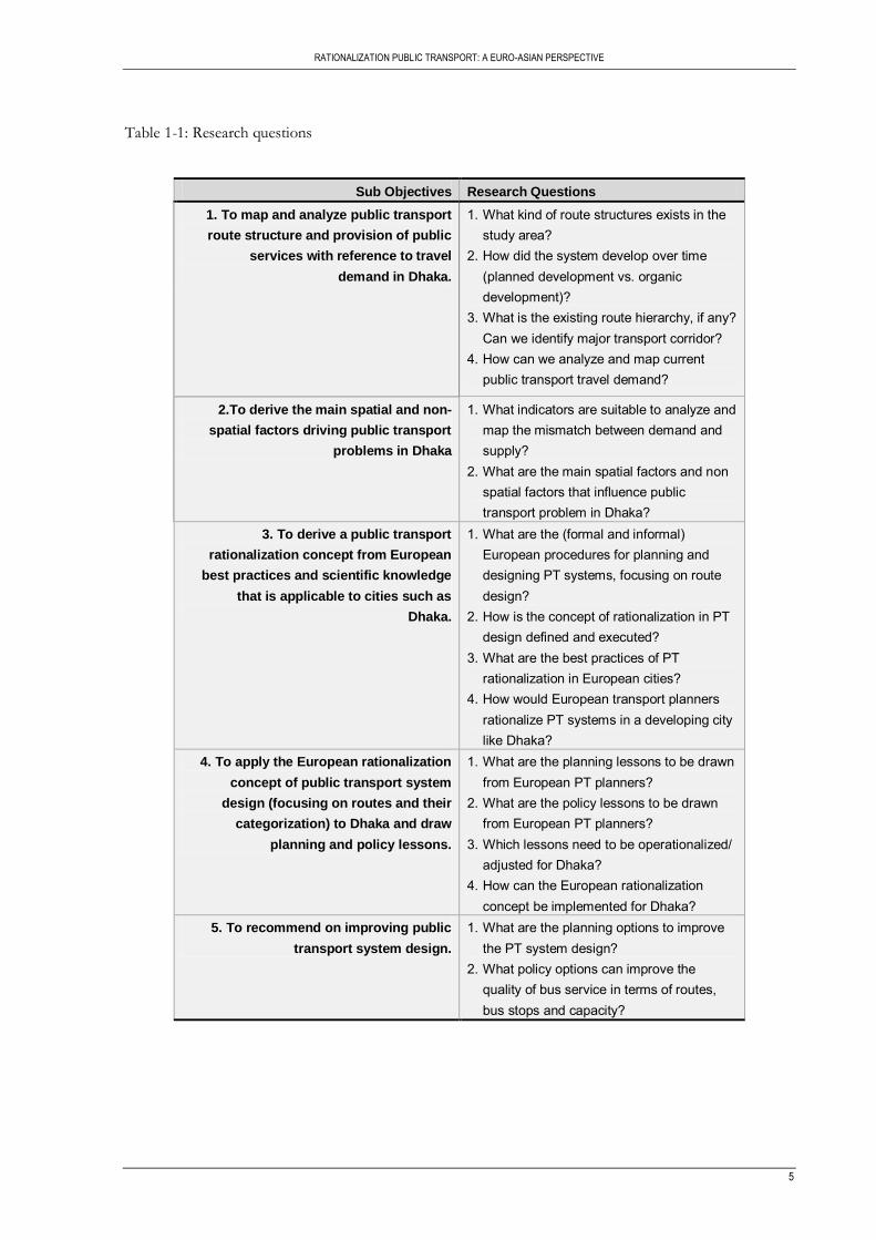
Table 1-1: Research questions ..................................................................................................................................... 5
Table 2-1: Research design matrix ............................................................................................................................ 11
Table 2-2: Data set used ............................................................................................................................................. 13
Table 3-1: Past population of DCC .......................................................................................................................... 18
Table 3-2: Population density of DCC .................................................................................................................... 19
Table 3-3: Area coverage by proximity to bus stops ............................................................................................. 24
Table 4-1: Key features of MRT systems ................................................................................................................ 36
Table 4-2: Transit system requirements ................................................................................................................... 43
Table 5-1: Network hierarchy.................................................................................................................................... 50
Table 6-1: Basic requirements for PT ...................................................................................................................... 55
Table 6-2: Requirements of attractive PT ............................................................................................................... 56
Table 6-3: Requirement of safe PT........................................................................................................................... 56
Table 6-4: Requirement of effective PT .................................................................................................................. 56
Table 6-5: Requirement of affordable PT ............................................................................................................... 57
Table 6-6: Requirement of effective PT .................................................................................................................. 57
Table 7-1: Key features of proposed Backbone network ..................................................................................... 70
Table 7-2: Service provision of existing bus route and proposed backbone network ..................................... 73
Table 8-1: Increasing trend of total population, area and density of Dhaka Mega City .................................. 85
Table 8-2: Increasing trend of population of DCC based on Thana .................................................................. 85

vii
LIST OF MAPS
Map 3-1: Location and administrative unit of Dhaka city ....................................................................................16
Map 3-2: Land use of Dhaka city, 2000 ...................................................................................................................17
Map 3-3: Population distribution and density of DCC .........................................................................................19
Map 3-4: Road network and existing bus route and bus stops of Dhaka city ...................................................22
Map 3-5: PT route density per ward in Dhaka city ................................................................................................23
Map 3-6: Proximity to existing bus stops and coverage of residential area within 400 meter buffer ............25
Map 3-7: Major corridors and hotspots of Dhaka city ..........................................................................................27
Map 5-1: Almere region and overview of its transport system ............................................................................53
Map 7-1: Proposed Backbone network ....................................................................................................................63
Map 7-2: Location of feeder route (conceptual). ....................................................................................................64
Map 7-3: Feeder route layout (option) .....................................................................................................................65
Map 7-4: Dhaka city map showing three gateways ................................................................................................66
Map 7-5: Location of terminals (existing and proposed) ......................................................................................67
Map 7-6: Accessibility to CBD by existing bus route, two BRT line and LRT line. ........................................71
Map 7-7: Accessibility to CBD by backbone network...........................................................................................72
Map 8-1: Historical settlement pattern of Dhaka city. ..........................................................................................83
Map 8-2: Accessibility to major health facilities by existing bus route and proposed backbone network ....89
Map 8-3: Accessibility to industrial zone by existing bus route and proposed backbone network................89

viii
ACRONYMS
BBS : Bangladesh Bureau of Statistics
BRT : Bus Rapid Transit
BRTA : Bangladesh Road Transportation Authority
BRTC : Bangladesh Road Transportation Corporation
CBD : Central Business District.
CNG : Compressed Natural Gas.
DCC : Dhaka City Corporation.
DITS : Dhaka Integrated Transport Study.
DMA : Dhaka Metropolitan Area.
DMDP : Dhaka Metropolitan Development Plan.
DUTP : Dhaka Urban Transport Project.
EBRD : European Bank of Reconstruction and Development.
GIS : Geographic Information System.
JBIC : Japan Bank for International Cooperation.
JICA : Japan International Cooperation Agency.
LRT : Light Rail Transit.
MRT : Mass Rapid Transit.
NMT : Non Motorized Transport.
PT : Public Transport.
RAJUK : Rajdhani Unnayan Kartipakha.
RHD : Roads and Highway Department.
SPZ : Specific Planning Zone.
STP : Strategic Transport Plan.
TAZ : Traffic Analysis Zone.
WB : World Bank.
RATIONALIZATION PUBLIC TRANSPORT: A EURO-ASIAN PERSPECTIVE
1
1. INTRODUCTION
This chapter starts with a general introduction, background and justification of the research. It further
continues with defining research problem, and research objective. Research questions are accordingly
shown for each research objectives in the following sections. At the end of chapter, a conceptual
framework structuring the ideas of the research will be explained.
1.1. General introduction
Mobility and accessibility provided by the transport system play a major role in influencing the location of
social and economic activity and shaping the form and size of cities(Zuidgeest, 2005).Transportation is the
backbone for the development of a city, both socially and economically (Murray & Davis, 1998; World
Bank, 1996). Gwilliam (2002), argues that congestion slows down the economic growth. This is as a result
of time lost in congestion which has an economic value (Banister, 2008). The efficiency of transportation
network is fundamental to the connectivity of the social and physical functioning of the urban settlements,
a precondition for economic prosperity and creation of a liveable city.
With the growth of the city footprint, travel distance to connect furthers destination point‟s increase
causing a direct proportional expansion in the mobility network. As the city develops socially and
economically, land prices in the city centre rises and higher density of land sharing results to congestion.
The urban poor may become displaced and move to the city outskirts for settlement. The rich on the
other hand, because of their quest for more space, also move much further away from the city centre. This
introduces urban sprawl and makes the city size large introducing longer distances between activity places.
With such long distances between activities, walking and cycling become unsuitable modes of transport.
Without the provision of an efficient public transport, people tend to rely on the use of private automobile
(Banister, 2008; Gwilliam, 2002). The use of private automobiles for individual mobility increases the
carbon footprint apart from creating congestion on roads, has other environmental and economical
detrimental effects. The provision of an efficient transportation system is thus needed to curb the
continual increase in private automobile use and promote shared mobility fostering responsible
citizenship.
1.2. Background of research
The evolution and growth of a city is much related to the transportation of its people between activity
locations (Murray & Davis, 1998; Rodrigue, Comtois, & al, 2009). Transportation planning is therefore a
critical element in the development of a city. A proficient transportation network forms the basis by which
the economic development of a city evolves and the means of interaction in society flourishes. The
inefficiency of such infrastructures therefore hinders the development and interaction of cities mobility.
Public Transport (PT) planning can be seen as an important component of transportation planning. Public
transport is a collection of modes of transport which are available to the public irrespective of ownership
(White, 2002), also called mass-transit in a city context. It can be provided by various types of modes;
however, in most urban centres in developing cities, it is provided by a wide range of buses and minibuses.
Public transport plays a crucial role in the overall success of a city‟s transportation system. It sustains
RATIONALIZING PUBLIC TRANSPORT: A EURO-ASIAN PERSPECTIVE
2
mobility of the working class unable to afford private vehicle, to those who can‟t have their own car, helps
in creating and maintaining liveable communities with high density land use, relieves congestion, assures
long term sustainability in terms of shared resource consumption and being responsive to the
environment. It also provides large number of transport opportunities at once in order to meet the
maximum demand during the peak hours. Studies have shown, in trying to control congestion on the
roads, options like the integration of land use and transport, widening or construction of new roads have
been effective. However, the provision of public transport has proven to be much efficient in controlling
congestions and to have efficient public dispersion.
The efficiency of public transport infrastructure is much affected by the demand for major infrastructures.
It is most efficient in areas with higher demand for such transportation, which in return is economically
viable to its high investment. However when the demand exceeds the supply level (e.g. capacity) of those
infrastructures, efficiency drops and safety on the road is compromised. This demand for transportation is
brought about by the increased population of connecting nodes, cities, the rural-urban migration, and the
scope for socio-economical facilities i.e. better opportunities for jobs, medical facility and educational
scope etc. thus the economic viability of the people which leads to an increase in the usage of private
vehicles.
Public transport system is a process evolving over time and is not always directly responsive to the
changing demand vs. supply to achieve equilibrium overnight, like a private vehicle solution. Capital
investment is simply too high for a mass transit network. Then the question arises as to how best to cope
with increasing change in demand with the existing infrastructure public transport infrastructure. The
public transport infrastructure investment is directly proportional to the possible economical turnover and
the population serviced.
1.3. Justification
From the research background, it is quite clear that various factors such as population of a city; the rural-
urban migration, the scope for socio-economic facilities etc. have come to realize the important role-play
in finding sustainable solutions to solving this question with existing infrastructure for public transport.
This increase in population and economy in a city leads to higher trip rates. Without proper spatial
planning of the city in terms of land use distribution, this may lead to long travel times as well. With the
increase in the economic status coupled with the lack of alternative transportation modes, private
automobile ownership and trips may increase (M.G. Badami & Haider, 2007; Palmner, Astrop, & al., 1996;
World Bank, 1996). The increase in private automobile use which typically has a lower occupancy rate may
lead to an increase in congestion on the roads without the proper transportation infrastructures
(Alterkawi, 2006; Beirão & SarsfieldCabral, 2007; Gwilliam, 2002; Martens, 2004).
Experiences in most countries show that construction of new roads or widening of roads only solves the
problem of congestion for a while (Tiwari, 2002). It encourages the use of private vehicles which lead
again to congestion and its associated side effects like air and noise pollution (Beirão & SarsfieldCabral,
2007). As a result of the financial constraints faced by many countries, especially the developing countries,
an improved public transport system seems the most likely solution to controlling congestion on the roads
as compared to investing in the construction of road infrastructures (Palmner, et al., 1996). This move to
tell us that the provision of an efficient public transport is a more likely answer to curbing congestion in
future plans of a city (Mackett, 2001; Newman & Kenworthy, 1999).
In a developing city like Dhaka, to invest more on infrastructure to meet the growing demand is often
quite expensive rather an effort is needed to tackle the problem with innovative planning solutions and

RATIONALIZATION PUBLIC TRANSPORT: A EURO-ASIAN PERSPECTIVE
3
rethinking the existing infrastructure. One way to solve this problem is rationalizing the existing public
transport network structure. The concept of rationalization can be defined as a structured process to
increase the effectiveness with a maximize use of existing resources. Rationalization in terms of road
infrastructure or systems can be achieved in a various ways, by establishing hierarchy of routes, optimize
bus-stop points with density distribution changes, proper integration of motorized and non motorized
transport and providing policy framework etc. This study is concerned with the rationalization of public
transport system (restructuring strategic route network) focusing on establishing hierarchy of routes, based
on planning lessons from European best practice.
1.4. Research problem
With the growing urban population and the demand for mobility increasing, pressure is added to the
limited infrastructural spine of cities in the developing world. It is reaching at the height of alarming
condition of congestion and inadequate poor quality of resources these cities are depending on. Being
major connection and mobility facilitator, the transport network is faced with growing challenges and
problems than ever before. These problems are triggered by interrelated trends such as urban population
growth and (rapid and unplanned) growth of cities (TranSafety, 1998). The inherent characteristics of
developing countries like population density, low income and spatially separated land uses and lack of
resources force these countries to depend on public transport, which can transport large numbers of
people at low cost. Generally in less developed countries, more than three quarters of peak travel public
transport are required for work trips (Ingram, 1998).
However, urban transportation systems are wilting under the pressure of ever growing demands on an
inadequate road network (Santhakumar, 2003). This poses a problem for the future if infrastructure
network planning is not done in a systematic way. With the increase in demand for reduced travel time on
a growing number of vehicles the challenge posed is of planning well served road network and maximizing
the existing route plans.
Government approaches to minimize traffic congestion include creation of a new link in a congested
network, the provision of new infrastructure, augmenting the capacity of existing transport networks
(Scott, Novak, & al, 2006), intelligent transport system, manipulating infrastructure demand and land use
policies and regulations (Button & D. Hensher, 2001). This intervention are seen as one sided, giving
inadequate attention transport network design (Vuchic, 2007).
With the growing population and economical limitations, the existing public transport capacities in most
of the developing countries do not satisfy the demand. The quality of travel on public transport is poor,
roads are badly maintained and managed and in most cases there is no hierarchy in the routes. Public
transportation systems which face the particular challenge caused from the accumulation of rapid and
uneven change with unfavourable inheritance from the past, potential for improving existing system by
rationalizing systems. Dhaka, the capital city of Bangladesh is one of the most over-populated cities in the
world. It houses about 14 million populations within 2,000 sq. km. land area (which means 7000
persons/sq. km). With a growth rate of about 8 percent per year, it is expected to be the seventh position
in terms of population by 2015 (Nagari, 2001). Rapid population increase over the past decade has
resulted in its transport services not being able to respond to the travel needs of its residents.
Demand has not been matched by sufficient investment in transport infrastructure, services and
management. Traffic and public transport conditions in Dhaka have seriously deteriorated, characterized
by traffic congestion and delays, inadequate traffic management, public transport crisis, unaffordable and
inaccessible public transport for may people, high accident rates, and increasing air pollution problems

RATIONALIZING PUBLIC TRANSPORT: A EURO-ASIAN PERSPECTIVE
4
(DUTP, 1998). The crisis in public transport is largely the result of growing concentration of population
and economic activities, and inadequate public transport systems. However, the projected population of
the city is expected to be around 16 million by the year 2015 and around 24 million by 2021 (DDC, 1998;
DDC., 1998); already alarming and will make the situation more critical if appropriate measures are not
taken to tackle the increasing travel demand.
Further, the road hierarchy is poorly established and most new development is taking place without any
coherent road system (DDC, 1998). This rapid population growth together with the limited space available
for new transport infrastructure will further aggravate the heavy congestion in Dhaka. The existing road
network in metropolitan Dhaka needs a planned restructuring to support an efficient public transport
system. This restructuring should be based on standard and functional road classification system, which
provides a hierarchy of roads, viz: Local streets, Collectors, Arterials, Access Controlled Freeways etc.
This research looks at rationalizing bus routes and upgrading bus transport services based on European
public transport planning tradition and best practices. An efficient use of limited space is therefore critical
for ensuring people‟s mobility, improving their quality of life, and boosting economic growth.
1.5. Research objectives and questions
1.5.1. Research objectives
The main objective of this research is to study rationalization of public transport, particularly public
transport system design (routes and their categorization) in Dhaka, Bangladesh, based on European public
transport planning tradition and best practices.
To aid in achieving this objective, several sub-objectives have been set:
1. To map and analyze public transport route structure and provision of public bus services with
reference to travel demand in Dhaka
2. To derive the main spatial and non-spatial factors driving public transport problems in Dhaka.
3. To derive a public transport rationalization concept from European best practices and scientific
knowledge that is applicable to cities such as Dhaka.
4. To apply the European rationalization concept of public transport system design (focusing on routes
and their categorization) to Dhaka and draw planning and policy lessons.
5. To recommend on improving public transport system design.
1.5.2. Research questions
To help address these sub-objectives, the following questions have been asked. It is deemed that
answering these questions is going to help in answering the main objective of this research.
RATIONALIZATION PUBLIC TRANSPORT: A EURO-ASIAN PERSPECTIVE
5
Table 1-1: Research questions
Sub Objectives Research Questions
1. To map and analyze public transport
route structure and provision of public
services with reference to travel
demand in Dhaka.
1. What kind of route structures exists in the study area?
2. How did the system develop over time (planned development vs. organic development)?
3. What is the existing route hierarchy, if any? Can we identify major transport corridor?
4. How can we analyze and map current public transport travel demand?
2.To derive the main spatial and non-
spatial factors driving public transport
problems in Dhaka
1. What indicators are suitable to analyze and map the mismatch between demand and supply?
2. What are the main spatial factors and non spatial factors that influence public transport problem in Dhaka?
3. To derive a public transport
rationalization concept from European
best practices and scientific knowledge
that is applicable to cities such as
Dhaka.
1. What are the (formal and informal) European procedures for planning and designing PT systems, focusing on route design?
2. How is the concept of rationalization in PT design defined and executed?
3. What are the best practices of PT rationalization in European cities?
4. How would European transport planners rationalize PT systems in a developing city like Dhaka?
4. To apply the European rationalization
concept of public transport system
design (focusing on routes and their
categorization) to Dhaka and draw
planning and policy lessons.
1. What are the planning lessons to be drawn from European PT planners?
2. What are the policy lessons to be drawn from European PT planners?
3. Which lessons need to be operationalized/ adjusted for Dhaka?
4. How can the European rationalization concept be implemented for Dhaka?
5. To recommend on improving public
transport system design.
1. What are the planning options to improve the PT system design?
2. What policy options can improve the quality of bus service in terms of routes, bus stops and capacity?
RATIONALIZING PUBLIC TRANSPORT: A EURO-ASIAN PERSPECTIVE
6
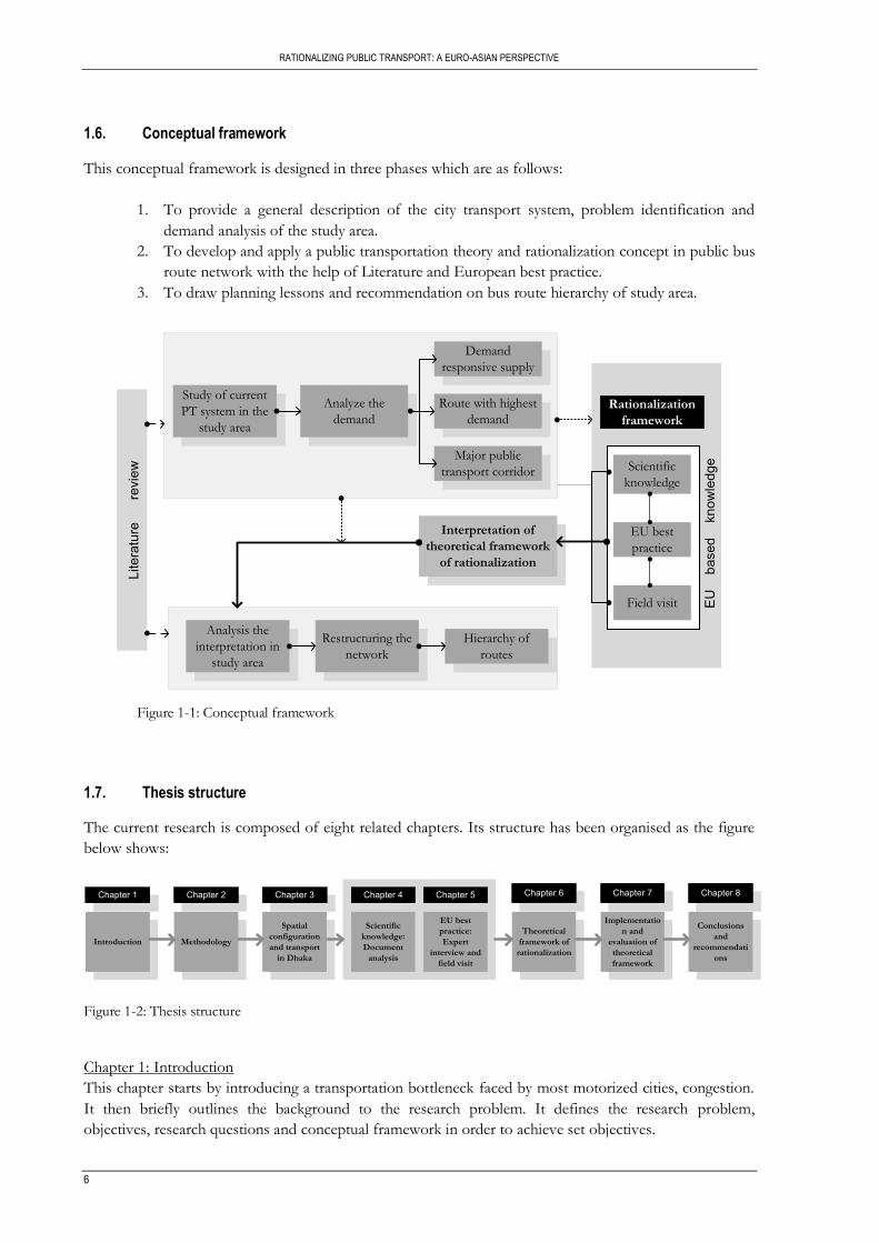
1.6. Conceptual framework
This conceptual framework is designed in three phases which are as follows:
1. To provide a general description of the city transport system, problem identification and
demand analysis of the study area.
2. To develop and apply a public transportation theory and rationalization concept in public bus
route network with the help of Literature and European best practice.
3. To draw planning lessons and recommendation on bus route hierarchy of study area.
Rationalization
framework
Scientific
knowledge
EU best
practice
Field visit
Interpretation of
theoretical framework
of rationalization
Demand
responsive supply
Route with highest
demand
Major public
transport corridor
Analyze the
demand
Study of current
PT system in the
study area
Analysis the
interpretation in
study area
Restructuring the
network
Hierarchy of
routes
EU
b
ased
k
now
ledg
e
Lite
ratu
re
re
view
Figure 1-1: Conceptual framework
1.7. Thesis structure
The current research is composed of eight related chapters. Its structure has been organised as the figure
below shows:
Chapter 1 Chapter 2 Chapter 3 Chapter 4 Chapter 5 Chapter 6 Chapter 7
Introduction Methodology
Spatial
configuration
and transport
in Dhaka
Scientific
knowledge:
Document
analysis
EU best
practice:
Expert
interview and
field visit
Theoretical
framework of
rationalization
Implementatio
n and
evaluation of
theoretical
framework
Chapter 8
Conclusions
and
recommendati
ons
Figure 1-2: Thesis structure
Chapter 1: Introduction
This chapter starts by introducing a transportation bottleneck faced by most motorized cities, congestion.
It then briefly outlines the background to the research problem. It defines the research problem,
objectives, research questions and conceptual framework in order to achieve set objectives.

RATIONALIZATION PUBLIC TRANSPORT: A EURO-ASIAN PERSPECTIVE
7
Chapter 2: Methodology
This chapter deals with the research methodology where the research process, research design, case study
approach, data collection techniques and data processing and analysis are discussed.
Chapter 3: Spatial configuration and transport in Dhaka
Chapter highlights the concerns with Dhaka as the research area narrating an overview of the city, its land
use, population and transportation system. Also a brief discussion on the existing situation of public
transport challenges and its deficiencies is presented.
Chapter 4: Scientific knowledge: document analysis
This chapter provides a discussion on the importance of public transport planning and the problem faced.
Development of sustainable urban transport in reducing congestions and related effects are also discussed.
The provision of bus transportation system and its challenges are discussed.
Chapter 5: EU best practice: Expert interview and field visit
This chapter emphasises on experts interview and field visit. Public transport experts are consulted to
provide opinions in rationalization of PT and also through field visit to find the example of successful
public transport planning.
Chapter 6: Theoretical framework of rationalization
The focus of this chapter is to identify the theoretical framework of rationalization and its significance.
The chapter concludes by developing the theoretical framework of rationalization by summarizing
scientific knowledge and expert‟s opinion on successful transport planning.
Chapter 7: Implementation and evaluation of theoretical framework
This chapter describes the implementation of European rationalization concept of public transport design
(focusing on routes and their categorization) to the research area Dhaka and finally concludes with the
evaluation of few aspects of framework.
Chapter 8: Conclusion and recommendation
This chapter presents the findings and conclusions of research, and suggesting recommendations for
future research direction.


RATIONALIZATION PUBLIC TRANSPORT: A EURO-ASIAN PERSPECTIVE
9
2. METHODOLOGY
This chapter gives an overview of the methodological approaches in addressing the research questions of
the study. The research design adapted to three phases of research and describes all relevant and required
data, including the data sources and methods that are being used. First part elaborates methodological
approaches to define rationalization framework of public transport. Second part gives some background
on the fieldwork which is intended to capture planning practises in the EU and concluding the chapter to
come up with a theoretical framework to rationalize public transport.
2.1. Research methodology
The research methodology employed in this thesis, outlines the steps used to answer the research
questions as described in table 1-1. The research design of this study is shown in table 2-1. It presents the
data that is required, the sources of data collection and methods applied.
The research has three consecutive phases. The first phase gives problem analysis in which the main
problems present in the study area are discussed through literature review and study area inventory. The
issues that are looked at are road network conditions, existing bus routes, bus stops, population data,
terminals and organizational issues etc., which are linked to the potential travel demand in terms of
population density, in order to check the demand responsiveness to supply. To derive the main spatial and
non-spatial factors driving public transport problems in Dhaka city the demand/supply mismatch has
been studied and reflected on. The main spatial factors like connectivity from north to south or east to
west, terminal locations, demand oriented supply of PT etc. but also non-spatial factors like reasons for
migration, unawareness of traffic laws, public awareness regarding public transport networks, proper
demarcation or signing of all routes, inefficient authorities related to PT etc. have been listed based on
literature, telephonic interviews and prior knowledge of the system. These factors complement the spatial
analysis. Through analyzing and mapping of the study area, most of the factors (spatial and non-spatial)
become visible which worked as a background for the theoretical framework development of the next
phase. And also the identification of key public transport expertise which ultimately led to the
development of theoretical framework of rationalization is accomplished.
PT systems should be planned in terms of bus routes, stops, capacity etc. but in the study area at hand, the
PT planning is one of the oldest plans in South Asian region, which has naturally evolved over the past
decades. To rationalize the existing PT routes, examples of cities that went through a rationalization
process and concepts and notions of rationalization by PT planners in European cities are needed. So,
phase two is to understand the PT theory and rationalization concept in relation to public bus route
network with the help of literature and European best practice which is mainly the field work stage.
Therefore, formal and informal knowledge is gathered through interview on European best practice and
European scientific knowledge regarding PT rationalization. This is done to finally come up with a
theoretical framework of rationalization which based on scientific literature, expert interview and visit to
one of the example of successful PT practice.

RATIONALIZING PUBLIC TRANSPORT: A EURO-ASIAN PERSPECTIVE
10
In the final phase of the research, knowledge of PT planners and expert base scientific knowledge have
been used to define a theoretical framework of rationalization of PT in the context of the study area.
Accordingly a categorization of PT routes and hierarchy of the PT systems have been identified and a
proposal regarding bus network improvement has been prepared based on EU experience in the
rationalization of public transport. Finally, a proposal regarding bus network improvement has been
prepared based on EU experience in the rationalization of public transport and recommendations on PT
rationalization in PT planning and policies are given.
The general methods followed to achieve the objective are document analysis, interviews with public
transport expertise and a visit to one of the PT planning example in the Netherlands, complemented with
data collection, preparation and analysis for Dhaka.
Real world problem
Research problem definition
Research objectives
Problem analysis of study area
Demand
- potential demandCurrent demand
Supply
- network hierarchyNetwork structure- routes/stops
Inventory of problems
Data
Population data
Road network
Bus route
Bus stops
Prob
lem
ana
lysis
pha
se
Rationalization practiced in European cities
Policies related to rationalization
Interpretation of rationalization
Analysis the interpretation in relation to study area
Theo
retic
al fr
amew
ork
Restructuring of routes( at strategic level)
Proposal for PT network improvement
Conclusion and recommendation
Impl
emen
tatio
n
terminals
Organization
PT theory and rationalization
Interview
EU best practice
EU based knowledge
Lite
ratu
re re
view
Doc
umen
t ana
lysi
s
Figure 2-1: Research methodology

RATIONALIZATION PUBLIC TRANSPORT: A EURO-ASIAN PERSPECTIVE
11
2.2. Research design matrix
The research matrix below indicates the required data, their sources and the tools needed to complete the
various sub objectives of this research. These are done in achieving the main objective of the research.
Table 2-1: Research design matrix
Research Questions Data requirement Method of data analysis
1. What kind of route structures exists in the study area? How did the system develop over time (planned development vs. organic development)? What is the existing route hierarchy, if any? Can we identify major transport corridor? How can we analyze and map current public transport travel demand?
Relevant literature and bus route information Relevant literature Relevant literature and transport data Land use and transport data
GIS analysis Literature review Literature review and GIS analysis GIS analysis
2. What indicators are suitable to analyze and map the mismatch between demand and supply? What are the main spatial factors and non spatial factors that influence public transport problem in Dhaka?
Relevant literature and transport data Relevant literature
GIS analysis Literature review and GIS analysis
3. What are the (formal and informal) European procedures for planning and designing PT systems, focusing on route design? How is the concept of rationalization in PT design defined and executed? What are the best practices of PT rationalization in European cities? How would European transport planners rationalize PT systems in a developing city like Dhaka?
Relevant literature and interview Relevant literature and interview Relevant literature and interview Relevant literature and interview
Literature review Literature review Literature review Literature review
4. What are the planning lessons to be drawn from European PT planners? What are the policy lessons to be drawn from European PT planners? Which lessons need to be operational zed/adjusted for Dhaka? How can the European rationalization concept be implemented for Dhaka?
Relevant literature and interview Relevant literature and interview Relevant literature and interview Relevant literature and interview
Literature review and GIS analysis Literature review and GIS analysis Literature review and GIS analysis Literature review and GIS analysis
5. What are the planning options to improve the PT system design? What policy options can improve the quality of bus service in terms of routes, bus stops and capacity?
Relevant literature and interview Relevant literature and interview
GIS analysis and discussion GIS analysis and discussion
2.3. Primary data collection
The primary data collection is mainly dealt with capturing knowledge from established and planned cities
in Europe regarding PT, meeting and discussion with public transport experts and scientific knowledge
regarding planning and policies for implementation of rationalization concept in the study area.
RATIONALIZING PUBLIC TRANSPORT: A EURO-ASIAN PERSPECTIVE
12
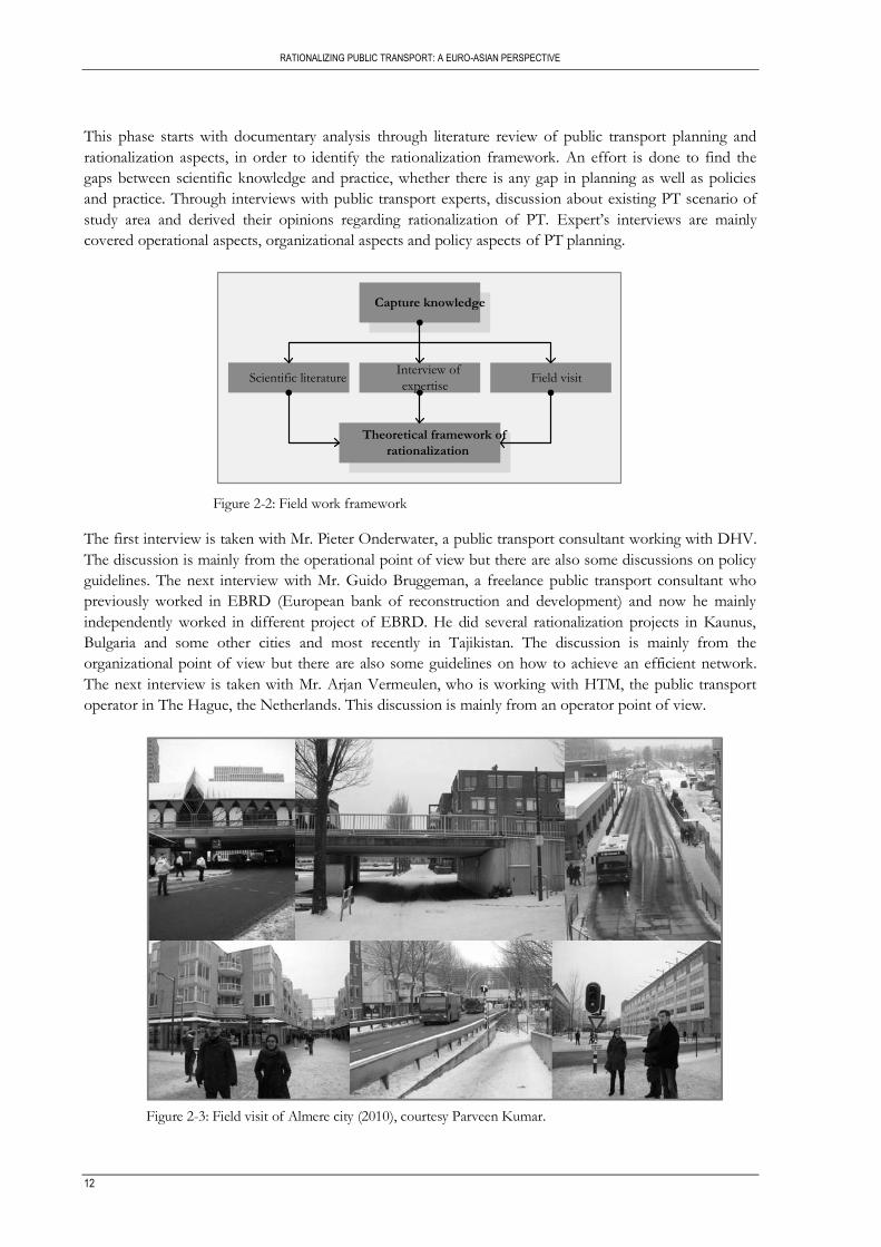
This phase starts with documentary analysis through literature review of public transport planning and
rationalization aspects, in order to identify the rationalization framework. An effort is done to find the
gaps between scientific knowledge and practice, whether there is any gap in planning as well as policies
and practice. Through interviews with public transport experts, discussion about existing PT scenario of
study area and derived their opinions regarding rationalization of PT. Expert‟s interviews are mainly
covered operational aspects, organizational aspects and policy aspects of PT planning.
Capture knowledge
Scientific literatureInterview of
expertiseField visit
Theoretical framework of
rationalization
Figure 2-2: Field work framework
The first interview is taken with Mr. Pieter Onderwater, a public transport consultant working with DHV.
The discussion is mainly from the operational point of view but there are also some discussions on policy
guidelines. The next interview with Mr. Guido Bruggeman, a freelance public transport consultant who
previously worked in EBRD (European bank of reconstruction and development) and now he mainly
independently worked in different project of EBRD. He did several rationalization projects in Kaunus,
Bulgaria and some other cities and most recently in Tajikistan. The discussion is mainly from the
organizational point of view but there are also some guidelines on how to achieve an efficient network.
The next interview is taken with Mr. Arjan Vermeulen, who is working with HTM, the public transport
operator in The Hague, the Netherlands. This discussion is mainly from an operator point of view.
Figure 2-3: Field visit of Almere city (2010), courtesy Parveen Kumar.

RATIONALIZATION PUBLIC TRANSPORT: A EURO-ASIAN PERSPECTIVE
13
Finally the field work finished with a visit of Almere city in the Netherlands which is mainly planned as a
traffic leading city. First a presentation was given at the municipality followed by tour through the city
centre.
The process is expected to be a loop, where documents lead to more literature, and literature provides
more knowledge. Finally through the document analysis, interview and field visit, some lessons of
planners‟ ideas and knowledge to interpretation of rationalization in a theoretical framework have been
drawn.
2.4. Secondary data collection
The study is based on both primary and secondary sources of information. Primary data are collected
through expert‟s interview and field visit. Interviews are conducted with key public transport experts,
working in different institutions and organizations.
A list of secondary data sources is provided in table 2.1 below. Some of them are digital sources, where as
others were hard copies. The bus routes are digitized. The extent of analysis is mainly at Dhaka city
corporation (DCC) level.
`
Table 2-2: Data set used
Data Format
Dhaka city ward map GIS Metropolitan boundary GIS
Existing transport network GIS Land use map GIS
Bus route Hard copy Bus stops Hard copy
Population census Hard copy
2.5. Data processing
The primary and secondary are prepared for analysis. A general procedure is given in this section; however
a more detailed procedure to what has done at each phase is given in chapter three and four.
2.5.1. Primary dataset
The information realised from documents, interviews with PT experts and field visit are mainly form the
base to establish the theoretical framework of rationalization.
2.5.2. Secondary dataset
Reports, maps and power point presentations are used for references. A personal geo-database is created
out of the entire individual transport layer. Also land use shape file, population data are added to relevant
layer. The format for the transport network layer (existing road, existing rail) is a shape file in ArcGIS
format. The transport network layer is cleaned to ensure that topology is maintained. More so some
portions of the transport network layer (vector) is edited. Existing bus routes and bus stops are digitized
from the hard copy.

RATIONALIZING PUBLIC TRANSPORT: A EURO-ASIAN PERSPECTIVE
14
Output from the framework establishing hierarchy of routes are analysed, first considering the existing
transport infrastructure then doing same for the proposed backbone network.
2.6. Conclusion
This chapter is complied with describing the thesis methodology. To rationalize public transport in the
study area, here derived three phases of methodology to implement PT rationalization approach in study
area. Firstly literature review for scientific knowledge of methodology approaches to achieve
rationalization of public transport. Secondly it gives an explanation of fieldwork which is interview to
experts to capture planning practises in EU and finally is to come up with a theoretical framework to
rationalize public transport in the study area.
RATIONALIZATION PUBLIC TRANSPORT: A EURO-ASIAN PERSPECTIVE
15
3. SPATIAL CONFIGURATION AND TRANSPORT IN DHAKA
3.1. Background of the study area: Dhaka city
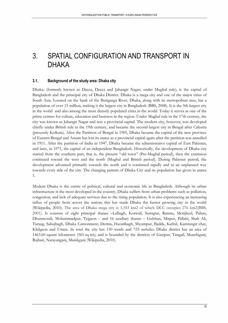
Dhaka; (formerly known as Dacca, Decca and Jahangir Nagar, under Mughal rule), is the capital of
Bangladesh and the principal city of Dhaka District. Dhaka is a mega city and one of the major cities of
South Asia. Located on the bank of the Buriganga River, Dhaka, along with its metropolitan area, has a
population of over 15 million, making it the largest city in Bangladesh (BBS, 2008). It is the 9th largest city
in the world and also among the most densely populated cities in the world. Today it serves as one of the
prime centres for culture, education and business in the region. Under Mughal rule in the 17th century, the
city was known as Jahangir Nagar and was a provincial capital. The modern city, however, was developed
chiefly under British rule in the 19th century, and became the second-largest city in Bengal after Calcutta
(presently Kolkata). After the Partition of Bengal in 1905, Dhaka became the capital of the new province
of Eastern Bengal and Assam but lost its status as a provincial capital again after the partition was annulled
in 1911. After the partition of India in 1947, Dhaka became the administrative capital of East Pakistan,
and later, in 1971, the capital of an independent Bangladesh. Historically, the development of Dhaka city
started from the southern part, that is, the present “old town” (Pre-Mughal period), then the extension
continued toward the west and the north (Mughal and British period). During Pakistan period, the
development advanced primarily towards the north and it continued rapidly and in an unplanned way
towards every side of the city. The changing pattern of Dhaka City and its population has given in annex
1.
Modern Dhaka is the centre of political, cultural and economic life in Bangladesh. Although its urban
infrastructure is the most developed in the country, Dhaka suffers from urban problems such as pollution,
congestion, and lack of adequate services due to the rising population. It is also experiencing an increasing
influx of people from across the nation; this has made Dhaka the fastest growing city in the world
(Wikipedia, 2010). The area of Dhaka mega city is 1,353 km2 of which DCC occupies 276 km2(BBS,
2001). It consists of eight principal thanas –Lalbagh, Kotwali, Sutrapur, Ramna, Motijheel, Paltan,
Dhanmondi, Mohammadpur, Tejgaon – and 16 auxiliary thanas – Gulshan, Mirpur, Pallabi, Shah Ali,
Turaag, Sabujbagh, Dhaka Cantonment, Demra, Hazaribagh, Shyampur, Badda, Kafrul, Kamrangir char,
Khilgaon and Uttara. In total the city has 130 wards and 725 mohallas. Dhaka district has an area of
1463.60 square kilometers (565 sq mi); and is bounded by the districts of Gazipur, Tangail, Munshiganj,
Rajbari, Narayanganj, Manikganj (Wikipedia, 2010).
RATIONALIZING PUBLIC TRANSPORT: A EURO-ASIAN PERSPECTIVE
16
Map 3-1: Location and administrative unit of Dhaka city Source: Dhaka City State of Environment, 2005
3.2. Land use pattern
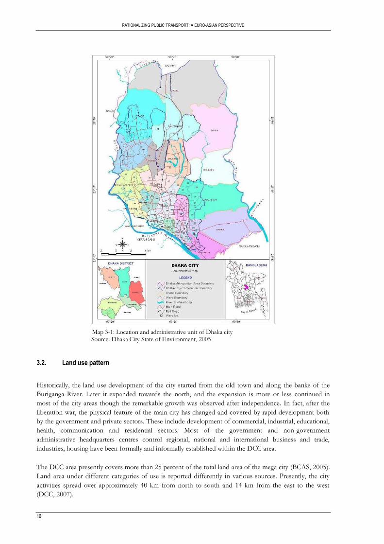
Historically, the land use development of the city started from the old town and along the banks of the
Buriganga River. Later it expanded towards the north, and the expansion is more or less continued in
most of the city areas though the remarkable growth was observed after independence. In fact, after the
liberation war, the physical feature of the main city has changed and covered by rapid development both
by the government and private sectors. These include development of commercial, industrial, educational,
health, communication and residential sectors. Most of the government and non-government
administrative headquarters centres control regional, national and international business and trade,
industries, housing have been formally and informally established within the DCC area.
The DCC area presently covers more than 25 percent of the total land area of the mega city (BCAS, 2005).
Land area under different categories of use is reported differently in various sources. Presently, the city
activities spread over approximately 40 km from north to south and 14 km from the east to the west
(DCC, 2007).
RATIONALIZATION PUBLIC TRANSPORT: A EURO-ASIAN PERSPECTIVE
17
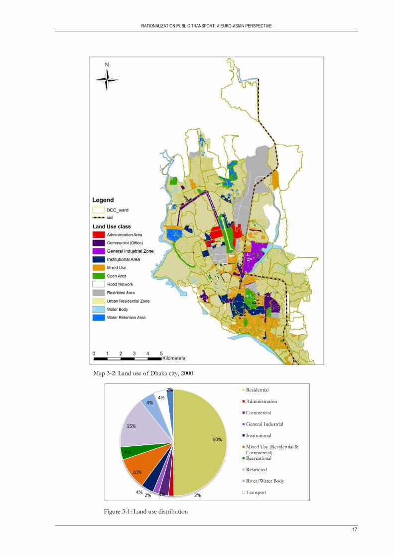
Map 3-2: Land use of Dhaka city, 2000
Figure 3-1: Land use distribution
50%
2%3%2%4%
10%
4%
15%
4%4%
2% Residential
Administration
Commercial
General Industrial
Institutional
Mixed Use (Residential & Commercial)Recreational
Restricted
River/Water Body
Transport

RATIONALIZING PUBLIC TRANSPORT: A EURO-ASIAN PERSPECTIVE
18
3.3. Population growth trend and density
3.3.1. Population growth trends
Population size, growth by both migration and natural, has already made Dhaka a member of the world
mega city family. According to UN Population Report 2007, among the largest 30 cities of the world,
Dhaka ranked the 23rd
, 20th
, 14th
and 9th
position in the years of 1990, 1995, 2000 and 2005 respectively and
expected to be the 4th
largest city of the world with a population of 22.015 million by 2015 (UN Population
Division, World Urbanization Prospects: The 2007 Revision).
Although Dhaka‟s area is less than 1% of the country‟s total land area, it supports about 10% of the total
population and about 34% of the total urban population. After the independence of Bangladesh in 1971,
the city‟s population increased rapidly and in 1974 it was about 1.31 million. Population of DCC increased
along with the expansion of the city area as tabulated in Table 3-1 which indicates that population growth
of DCC area in the period of 1974-1981 was very high with the annual growth rate of about 10.9%. In the
following decade, the population growth rate dropped conspicuously. Evaluation of the population
increase in the period of 1991-2001 shows an annual growth rate of 3.80% within the DCC boundary.
Table 3-1: Past population of Dhaka city
Census year Population(Millions) Annual population growth rate(%)
1961 0.36 -
1974 1.31 9.90
1981 2.82 10.93
1991 3.61 2.49
2001 5.38 3.80
Source: BBS 1997 & 2001
3.3.2. Population density
Dhaka is the fastest growing mega-city in the world, with an estimated 300,000 to 400,000 new migrants,
mostly poor, arriving to the city annually. Most migrants come from rural areas in search of opportunities
which can provide new livelihood options for millions, translating to improvements in living standards.
Population density of Dhaka mega city was found to be around 5,000 persons/sq. km in 1991 while 7,900
persons/sq. km in 2001. In the year 2004, density is estimated at approximately 8,400 persons/sq. km.
However, the population density of DCC area is much higher than that of the mega city area, as in 1991 it
was approximately 16,300 persons/sq. km and in 2001 it was 19,500 persons/sq. km. The estimated
population density of DCC in 2004 was 21,500 persons/sq. km. In some parts of old Dhaka, the density is
even over 100,000 persons per square kilometre (BBS, 2001). With limited availability of flood-free land,
further densification of population along with haphazard encroachment of peripheral land of Dhaka
seems inevitable.
Increasing trend of population, area and density of Dhaka mega city in different years and population of
different thanas of DCC from 1981 to 2001 including old and new thanas are given in Annex 2.

RATIONALIZATION PUBLIC TRANSPORT: A EURO-ASIAN PERSPECTIVE
19
Map 3-3: Population distribution and density of Dhaka city.
Table 3-2: Population density of Dhaka city.
Census year Dhaka mega city (person/km
2) DCC (person/km
2)
1991 5,059 16,255
2001 7,918 19,485
2004 8,352 21,521
Source: BBS 1997 & 2001
3.4. Transport in Dhaka city
3.4.1. Overview
Being the administrative, commercial & cultural capital of Bangladesh, the Mega City Dhaka has a major
role to play in the socioeconomic development of the country and in the era of regional and sub-regional
cooperation. But the existing transportation system is a major bottleneck for the development of the city.
Unplanned urbanization, especially poor transportation planning and lower land utilization efficiency, has
turned the city into a dangerous urban jungle (M. S. Rahman, 2008) The rapid rise in population along
with increased and versatile urban land use patterns has generated considerable travel demand as well as
numerous transport problems in Dhaka City. It has resulted in a deterioration of accessibility, level of
service, safety, comfort, operational efficiency and urban environment. The population of the Dhaka
metropolitan area is expected to reach 36 million by 2024. This additional population will add new
RATIONALIZING PUBLIC TRANSPORT: A EURO-ASIAN PERSPECTIVE
20
dimensions to the urban fabric of Dhaka in the coming decades. To maintain the economic viability of
this City and to keep its environment sustainable, an efficient transportation system is imperative.
The transportation system of Dhaka is predominantly road based and non-motorized transportation
(mainly rickshaws) has a substantial share. Although a 37-km long rail-road passes through the heart of the
city but it has no contribution to city‟s transport system. There is a limited use of waterways, especially for
freight movements. The existing transportation infrastructure in Dhaka could not bear the current traffic
loads. The level of service and options of transport modes are not at all convenient for the passengers and
either for the environment (Karim, 1998). Dhaka‟s transport environment is characterized by mixed-
modes transports using the same road space, traffic congestion, delays, mismanagement, conflict of
jurisdictions, poor coordination among organizations and increasing environmental problems.
3.4.2. Road network
Established on the banks of the river Buriganga, Dhaka has been increasing in north-south direction. With
the expansion of the city, the road network of the city has also been growing time to time. The major
roads in the old part of Dhaka have been developed in the east-west direction and major roads in the new
part have been developed in the north south direction. The road network of the city had never been
planned specifically in cognizance with the well-developed process of trip generation, trip distribution,
modal split and route assignment. As a result, an irregular pattern of network, rather than a more efficient
pattern such as gridiron or redial-circumferential pattern, has been developed(Ahsan, 1990).
Dhaka‟s road network is nearly 3000 km (STP, 2004), of which 200 km primary roads, 110 km secondary
roads, 50 km feeder roads and rest 2640 km narrow roads, with few alternatives and connector roads and
it represents the proportion of road surface to built-up area hardly 7% as against 25% recommended for a
good city planning (Quium, 1995). With the exception of some well-planned residential areas, in most of
the areas the road network is quite narrow and alignment is poor. Widths of streets, within the old part of
Dhaka are narrower than other newly developed parts. There are only a few pedestrian overpass and
underpass. At present two flyovers are finished and some others are proposed for construction.
The existing road network in metropolitan Dhaka needs a planned restructuring to support an efficient
transport system. This restructuring should be based on standard and functional road classification system,
which provides a hierarchy of roads.
3.4.3. Road transport modes
Metropolitan Dhaka has traditionally been served by a wide variety of transport modes. These modes can
be broadly classified into two groups, motorized transport (viz. bus, mini-bus, truck, car, auto-rickshaw,
auto-tempo, motorcycle etc.) and non-motorized transports (viz. rickshaw, rickshaw van, bicycle, push cart
etc.)
Motorized Transport: Estimation from the data provided by „Statistical Year Book of Bangladesh‟ reveals
that the motor vehicle fleet in Bangladesh is growing as an average rate of 7% per year. But DUTP-II
(1998) claims that the vehicle population on road is growing as an average rate of 10% annually.
Non-Motorized Transport: Reliable estimate of non-motorized vehicle fleet is more difficult to obtain.
DCC limits the number of license issued to rickshaw owners to some 70,000. However, unofficial
estimates claim that the number of rickshaws plying in Dhaka city is three times the DCC figure(DUTP-
II, 1998).

RATIONALIZATION PUBLIC TRANSPORT: A EURO-ASIAN PERSPECTIVE
21
3.4.4. Terminals
A terminal station is a central location and important traffic generating mode from where buses may
originate, terminate or stop over en route to sub serve the over all route network in a given catchments
area. It provides passenger amenities and also provides passenger information regarding services. It is an
important traffic junction which is a focal point for smooth running of services.
Dhaka is served by three inter-city bus terminals and four BRTC bus depots exist where the terminals are
conveniently located with respect to the corridors they serve: Saidabad- Southern Corridor, Mohakhali-
Northern Corridor, Gabtoli North-Western Corridor. City Corporation owns the terminals of Dhaka city.
While terminals should be the place for passenger boarding and alighting, driver‟s refreshment and
passenger waiting facilities, in Dhaka the main function of the terminal can be described as rather bus
depot. Most of the privately owned buses take shelter in the terminals during idle time and as such it
remains overcrowded by the idle bus drivers, helpers and union members. All these along with the poor
supervision and maintenance practice have made the terminal area as most unwelcome place for the
passengers and on duty drivers.
3.5. Existing bus system of Dhaka city
3.5.1. Overview
Existing mass transit system in metropolitan Dhaka is mainly characterized by large bus, mini bus and
human hauler/auto-tempo. Bus and minibus routes tend to be concentrated along the limited number of
arterial roads, in a generally north-south orientation. Human hauler routes are more dispersed, penetrating
narrower roads, and include more east-west linkage.
The 2004 Dhaka STP divides buses into several categories: minibuses (41%), microbuses (30%), large
buses (13%), auto tempo/laguna maxi (12%), and staff and school buses (4%).
Residents of Dhaka understand the bus system as divided mainly into ticket buses and local buses. Ticket
buses have set stoppages on their routes, which can be located by the companies‟ respective ticket
counters. Their fares are collected on the curb side from ticket sellers associated with each private
company, and have a single conductor on board who checks tickets at the doorway. Almost all of the large
buses are ticket buses. Local buses have stoppages that are unmarked and have on-board fare collection.
Local buses can also be boarded and alighted from at any point on the route, at the conductor‟s discretion.
There are a handful of large buses that operate as local buses, but the vast majority of local buses are
minibuses.
Buses in Dhaka city are operated both in private and public ways. The private sector is dominating and
provides a monopoly service (95% of total bus services) compared to public sector operation. The present
bus services provide inefficient, unproductive, and unsafe level of services. Long waiting, delay on plying,
overloading, discomfort, and long walking distance from the residence/work place to bus stoppages are
some of the obvious problems that confront the users in their daily life.
Today's bus operation in Dhaka is characterized with the existence of 750 individual bus owners. Dhaka
city has only around 2500 buses as public transport whilst the current demand is more than 5,000.
However, only 1,300 of the existing buses are playing of which less than 200 are of improved quality (G.
Rahman, Majumder, & Rana, 1999). Public transport of the city is poor and disorganized with limited
coverage (DMDP, 1995). The present mass transit mode in the form of bus transport has not been able to
be popular and grow its share of catering demand. The poor institutional and regulatory framework,

RATIONALIZING PUBLIC TRANSPORT: A EURO-ASIAN PERSPECTIVE
22
reluctance to enforce existing legislation, and lack of enforcement reduce the capacity of existing roads
(DMDP, 1995).
Map 3-4: Road network and existing bus route and bus stops of Dhaka city
3.5.2. Bus stop and route location
Though the bus route lists of Bangladesh Road Transport Authority (BRTA) shows a total of 34 routes in
Dhaka City, including the sub-routes of different main routes it becomes 46 in total of which 13 routes are
not presently in operation (Amin, Rahman, Uddin, & Maniruzzaman, 2005; BRTA, 2002). Majority of the
routes are in north–south direction.
Normally bus stops are attributes of transport services which are designated place where a public transport
bus stops for the purpose of allowing passengers to board or leave a bus. Most passengers walk to reach
bus stops, and 500 meter is considered a convenient walking distance for human beings (Untermann,
1984). A study on bus routes and stoppages (Amin, et al., 2005) found majority of the bus riders in Dhaka
city use a particular bus services for the cheaper fare and walk to or from the bus stop. The study also
found that the majority of the stops are not located within a comfortable walking distance. Most of the
users have to walk for 15-20 minutes or 1-1.5 km and wait for a period of 20-30 minutes for a bus.
Bus/other transit stoppages and the city bus terminals suffer from poor operation and management. Most
of the stoppages are in bad condition, e.g., unauthorized use, blocked by parked vehicle and roadside
activities and water logging in rainy season. The basic elements of a stoppage such as proper shelter, route
information, schedule information and passenger waiting facilities are missing in most of the stoppages.

RATIONALIZATION PUBLIC TRANSPORT: A EURO-ASIAN PERSPECTIVE
23
Buses and other Para-transit vehicles most often stand at a place away from the designated bus stoppage.
This creates problem of reduction in effective road width and lack of safety and comfort for transit users.
3.5.3. Spatial analysis of existing bus route structure
PT (bus) route density
One parameter which is used to represent the coverage/distribution of bus service is route density, which
shows the number of bus lines between origins and destinations. PT route density is the quantity of bus
route lengths divided by their whole service area of the particular road. The denser the bus line is
distributed, the more people are expected to choose travelling by bus. Also the denser the route density
the shorter the walking distance. Low network density results in the small coverage of routes. According
to “Code for Transport Planning on Urban Road” (GB50220-95, 1995), the network density of bus routes
planned in urban central area should be a value in the range from 3 km/km2 to 4km/km2
Map 3-5: PT route density per ward in Dhaka city

RATIONALIZING PUBLIC TRANSPORT: A EURO-ASIAN PERSPECTIVE
24
As shown in the map 3-5, the spatial distribution of bus service is concentrated in central area. The bus
lines are dense in central area than peripheral areas. It shows that people of peripheral area have to walk
relatively long to reach bus route. From map 3-5 it‟s also clearly shown that the older part of Dhaka and
North western (Mirpur) part, Western suburbs and smaller part of eastern suburb where now new
residential area developed, which already mentioned in the analysis of major hotspots are not served by
the existing PT system. Here as PT system only include the existing bus system.
Proximity to bus stops
Proximity is an accessibility measure which shows the spatial extent of the service. It measures the
closeness of the service to either origins or destinations of people. Proximity of people to the service can
be measured using simple buffer analysis based on airline distance. However, this has a limitation that
buffering considers only direct path but in reality people walk along road and footpaths to get service at
stops. The service area of the bus stops is determined using the network analysis by computing the
walking time to bus stops.
However, some assumptions are made to make this analysis is possible. It is assumed that the population
is uniformly distributed in the service zones and the walking speed in Dhaka city is assumed to be 4
km/hr. This assumption is based from other studies done earlier.
By computing the service area of each bus stop using the network analyst, the total area within each
proximity zone of walking time is determined. Based on proximity analysis results table 3-3 and figure 3-2,
about 37% of the total area is covered within 10 minutes walking time to the bus stop. This means,
assuming the average walking speed of 4 km per hour, this proportion is covered within a distance close to
500 meters. And rest 63% area are not covered by existing bus stops as mentioned threshold (500 meters).
This result clearly mentioned that by the existing bus route 63% of the areas of DCC are not served by the
existing bus route and stops.
Table 3-3: Area coverage by proximity to bus stops
Walk time to bus stops(minutes) Area(%) Population(%)
0 - 5 11.19 15.19
5 - 10 25.83 20.91
10 - 15 21.99 21.88
15 – 20 17.22 21.53
20 - 30 23.77 14.49
Figure 3-2: Area and population coverage by existing bus stop
0
5
10
15
20
25
30
0-5 min 5-10 min 10-15 min 15-20 min 20-30 min
Are
a se
rved
(%)
Walking time range in minutes
Area coverage
Area served (%)
0
5
10
15
20
25
30
0-5 min 5-10 min 10-15 min 15-20 min 20-30 miin
Po
pu
lati
on
(%
)
Walking time in minutes
Population coverage

RATIONALIZATION PUBLIC TRANSPORT: A EURO-ASIAN PERSPECTIVE
25
And also table 3-3 and figure 3-2 shows the proximity of population to the existing bus stops based on the
walking time from their origin to bus stops. It is shown that about 36% of the population can access the
bus stop within 10 minutes walk time which is closer to a distance of 500 meter assuming a walking speed
of 4 km per hour and nearly 56% of the population walk up to 15 minutes (1000m) to get the bus stop. It
also shows that around 44% of the population has to walk more than 15 minutes to get the bus stop.
The buffer coverage is established 400 meters from each bus stop as indicates in Demetsky and Lin (1982).
Moreover, the buffer method is widely used in transportation planning, it is simple in calculation. It
assumes that walking distance for a transit user accessing a transit stop is the same as the Euclidean
distance. However, the actual walking distance is longer than Euclidean distance (Zhao, L. Chow, & et al,
2003) as cited in (Gutierrez & J. C. Garcia-Palomares, 2008).
Acceptable distance is divided into two groups, 1) within 400 meter people willing to walk to access the
bus stops, and 2) within 401 -1000 meter people willing to use other mode of transport such us rickshaw,
auto rickshaw etc. In the map 3-7 residential density is overlaid with 400 m buffer of existing bus stops to
show the coverage of existing bus stops.
Map 3-6: Proximity to existing bus stops and coverage of residential area within 400 meter buffer
3.5.4. Institutional setup
In Dhaka, three separate bodies such as Rajdhani Unnayan Katripakkha (RAJUK), Dhaka City
Corporation (DCC) and Dhaka Metropolitan Traffic Police (DMTP) are thought to be responsible for
construction of new transport infrastructures, physical maintenance of road elements and management of

RATIONALIZING PUBLIC TRANSPORT: A EURO-ASIAN PERSPECTIVE
26
traffic operations respectively. But there is no formal accountable interrelationship among these three
agencies. The public sector entity, Bangladesh Road Transport Corporation (BRTC), operates less than 2%
of the buses. The overall bus operations are regulated by a number of bodies with overlapping mandates.
The Bangladesh Road Transport Authority (BRTA) is empowered to regulate public transport vehicles.
The Road Transport Committee (RTC) is appointed by the BRTA to award route permits. The Dhaka
Transport Coordination Board (DTCB) plans and coordinates public transport services. The Dhaka
Metropolitan Police (DMP) is responsible for enforcing regulations. The Dhaka City Corporation (DCC)
is responsible for overall municipal governance and administration. Development partners such as the
World Bank have provided support to these authorities in infrastructure development, institutional
strengthening and policy support. Other key stakeholders include bus owners (individuals or companies),
bus workers, and commuters, owners of other modes of transport, civil society, the media, and politicians.
3.6. Major corridors and hotspots of Dhaka
In order to develop the strategic road network of the city as well as those which could provide major
connections to the growth poles/ satellite cities around Dhaka, it is necessary to identify the major arterial
road networks of the city which carry most of the North-South and East-West traffic. After a brief
analysis of the existing road network and existing situation (Map 3-5) reveals that there are about 5 major
North-South corridors whilst several missing links in the East-West direction, which need to be built on a
priority basis to provide alternative route for movement .
A corridor of about 5 km, for example, between Khilkhet and Kaptan Bazar, attracts flows of up to 2,300
pcu/hr and heavy public transport flows of almost 40,000 passengers per hour (pph) (Rahmatullah, 2005).
The traffic analysis along the Kazi Nazrul Islam Avenue towards Mymenshing Road indicates that this is a
heavy traffic demand corridor. In addition, along this corridor particularly high income group of people
live and generate private traffic, which are responsible for traffic congestion on these roads. The existing
Dhaka-Tongi regional line has all infrastructures from Zia International Airport to Mohakhali rail
Crossing. Slight modifications on the existing line and new development from Mohakhali rail crossing to
Sadarghat via Farmgate and Motijheel will tremendously increase commuter traffic and ease traffic
congestion.
The older part of Dhaka and Mirpur, East and Western suburbs are quite densely populated zones. There
the agglomeration of human activities in a small area is so intense that circulation of private vehicle causes
recurrent congestion, which no feasible expansion of the street system could eliminate. Commuting a
distance of three to four kilometres to certain spots like Gulistan, Motijheel, Old Dhaka, Moghbazar,
Malibagh, Gulshan, Banani, Dhanmondi, Science Laboratory, Green Road, Jatrabari, Sayedabad and
Mohakhali have become nightmares for city commuters. The traffic problem is also significantly fuelled by
the unplanned location of numerous shopping malls, commercial buildings, schools, hospitals and CNG
filling stations in various part of the city.

RATIONALIZATION PUBLIC TRANSPORT: A EURO-ASIAN PERSPECTIVE
27
Map 3-7: Major corridors and hotspots of Dhaka city
Figure 3-3: Image of major hotspots and corridors
Source: (Hoque & Choudhury, 2009)
3.7. Traffic congestion in Dhaka city
Traffic congestion is a consequence of disparity between transportation demand and supply. Demand for
transportation in urban areas is an increasing phenomenon for the continuous increase in urban
population and economic activities lagging behind the transportation supply. As a result, traffic congestion
has already become a part of urban transportation system.
The common terms that can be used to describe the present condition of Dhaka City are: congestion,
delays, pollution, etc. These are the symptoms of transportation system deficiencies of Dhaka. The
population of Dhaka has grown in 50 years from less than a million to over ten million. Now the
population is expanding at an average rate of 4.5% (DCC, 2001) annually. Motor vehicle ownership faces a
RATIONALIZING PUBLIC TRANSPORT: A EURO-ASIAN PERSPECTIVE
28
growth rate of average 10% annually (Monayem, 2001). Intermingle of motorized and non-motorized
modes results in a very low speed travel in its streets. With increasing rate of motorization, together with
heterogeneous mix of traffic, the road traffic situation of Dhaka is degrading day by day.
The causes of traffic congestion in Dhaka city can be divided into three broad categories. These are site-
specific causes, transportation system capacity related causes and planning or policy related causes. The
site-specific causes are mainly traffic management related problems. The important manoeuvrings like left
turning, through movement along the intersections etc. are often seriously obstructed for the poor quality
and in maximum cases absence of traffic management system, uncontrolled parking of both motorized
and non-motorized vehicles etc. In many locations of the road network, the effective roadway spaces are
reduced by roadside activities, presence of dustbins, hawkers etc. Such reduction in effective roadway
spaces in links and intersections creates bottlenecks to traffic flow and causes congestion. The population
of the city is increasing day by day but the capacity of the road network is not increasing at the same pace.
The lag between increasing travel demand and system capacity is resulting traffic congestion. Another
important factor is the uncontrolled increase in rickshaw traffic. As there is no segregation of motorized
and non-motorized traffic in the network, the increasing rickshaws are occupying the maximum roadway
space and compelling the other modes to move slowly and creating congestion.
The overall transportation system of Dhaka city has not been developed in a planned way rather it has
been developed in dynamic response to increasing travel demand. Even there is no definite policy to a
sustainable transportation system. Uncontrolled land-use together with increasing migration of rural
people towards Dhaka is increasing pressure on transportation system and creating traffic congestion and
other related problems.
3.8. Deficiencies in existing public transport system
Current supply of mass transit is much lower than the actual demand. Not only the lack of this supply,
there are also many other deficiencies in the existing system of mass transit. Japan Bank for International
Cooperation (JBIC) data sources reveal that service deficiencies indicated by users of rickshaw are
crowded condition of bus, long waiting time, lack of easy transfer, bus stops are not near from origin, long
boarding time. Service deficiencies indicated by bus users are discomfort and congestion. A survey on
pedestrians detected service deficiencies in the form of long waiting time, long travel time, lack of
comfort, lack of stoppages etc. These deficiencies can be categorized as land use and road limitations,
operational weaknesses, and user‟s points of view.
Land use and roadway deficiencies
1. Limited road space
As in many other cities in the region, systematic bus route planning based on a cycle of monitoring,
planning, and implementing adjustments to the network is not in place in Dhaka. Total space occupied by
roads and streets of Dhaka Metropolitan City is only 9% of its total space while that of other mega cities
cover approximately 25%. Though 9% of road area of the city is available, pavement area is only 6% of
total area (RMMS, 2004).
2. Lack of accessible road
In Dhaka city, there is a lack of sufficient accessible road. It is estimated that among the existing road
network about half of the road lacks sufficient width to accommodate motorized emergency vehicles. In
zone 1, 2, 3 and 7 more than 50% of road is inaccessible to large sized vehicles particularly to public
transports. In Dhaka city out of 1286 km road about 821 km of road is found to be accessible (if road
width is equal and more than 4.5 m) to motorized vehicles (RMMS, 2004).
RATIONALIZATION PUBLIC TRANSPORT: A EURO-ASIAN PERSPECTIVE
29
3. No road network pattern
As road network of Dhaka City evolved haphazardly without any plan and always to meet short term
travel need, the total road network does not show any well defined configuration. Instead, it is expanded
eccentrically in the north-south direction and allowing uncontrolled ribbon development.
4. Un-organized and non integrated road network
During last twenty to thirty years, significant road development has been taken place to cope with sudden
transformation of the city from provincial town to the capital of the country. But most of the transport
developments have been driven by ad hoc considerations having no explicit focus on analysis of existing
demand or future requirements. As a result, the road network of the city is not organized and integrated in
terms of connectivity.
5. Absence of east west continuous road
Present public transport problems are the lack of integration between land use and transport system. In
the city, there is not a single continuous main road in east-west direction. The road, which are existing in
this direction all are formed as a connecting road or link road. Therefore, vehicle cannot move thoroughly
in that direction. Absence of east-west connection has become the major problem for the entire road
network of Dhaka. Presently, such requirements are meeting by relatively narrow and poorly aligned
roads, which are far beyond to meet the existing demand in terms of capacity, speed and level of service.
6. Lack of bus lay on roads
There is very few designated place for bus stoppage in road side of Dhaka city. Most of the bus stop in
road side haphazardly with competition attitude and alighting and boarding passenger dangerously. This
makes always crowed on road side and influence pedestrian to move on road as well as decreases the
effective width of the carriage way.
Operational deficiencies
1. Mixed operation in major roads
Road network of Dhaka city is characterized by mix traffic system. All types of vehicles, both motorized
and non-motorized vehicles are in operation on each and every road, except some NMT restricted routes.
Where, all types of vehicles are played on the road, majority of road spaces occupied by rickshaw. Because
of the presence of non motorized vehicles, travel speed is significantly reduced for motorized vehicles and
a huge congestion occurred. Even where non-motorized vehicles are restricted, the majority of road space
is occupied by three wheeler vehicles.
2. Low roadway capacity and speed
Due to the complex mixture of motorized and non-motorized traffic and non-lane based movement over
the Dhaka city road network, the capacity & speed of vehicles has abruptly decreased. The capacity of
road lane and speed of the transport mode are very low compared to other capital cities in the world. That
is how the city is facing huge traffic congestion at everywhere of the Dhaka city.
3. Absence of bus priority measure
Public transport is currently not given any priority over other vehicle types and road users. Various forms
of bus priority ranging from traffic signal priority measures and bus lanes to possibly dedicated bus-ways
should be considered for application in Dhaka. There is no bus only routes or segregated bus lane on
roads.
4. Poor maintenance and surface condition of roads
The surface conditions of most of the roads are very poor. The surface of the roads are not smooth, as a
result, journey through vehicles on such roads is not comfortable. Because of the absence of periodic
maintenance of the roads, a lot of potholes exist on the surface of the roads. Rain water is stored in these
potholes and surface becomes worst. Travel on such roads is very much risky and accidents may occur on
such roads. If vehicles are operated continuously on such roads, vehicle‟s parts may damage.
RATIONALIZING PUBLIC TRANSPORT: A EURO-ASIAN PERSPECTIVE
30
5. Road space occupied other than traffic
Most of the roads are not fully used by traffic. Presence of dustbin on roads is very common in Dhaka
city. This significantly reduces the effective road width for traffic use. Road spaces are also occupied by
hawkers and retailer traders. In many places, construction materials for building are placed on the road.
These cause reduction in effective road width and make the road unsafe for vehicles. Again, on-street
parking also reduces road spaces and hinders smooth flow of traffic.
6. Fragmented ownership
Buses, which are main mass transit system in Dhaka, are operated by government authority and by
privately. The BRTC, which operates under immunity from regulation by licensing authorities, owns a
total of 306 buses operating on 15 routes in Dhaka. BRTC does not actually operate the buses, but sub-
contracts out the operations to private operators. The main problem of privately operated bus services is
that buses are owned by a large number of operators and also numerous small operators (Figure 3-3).
There are many operators who have only 2 to 3 buses and some private bus operators have 30 or more
buses. Multiple operators competing in same route, often leads to competition which results in results in
inefficient road use (Figure 3-3).
7. Deficient and improper place of bus terminal
All terminals are poorly designed with respect to terminal system requirements. Many components of the
system are totally absent along with some basic amenities. Utter disorder in using the terminal space, lack
of management and indiscipline of drivers and passengers are other reasons for congestion all those inter-
city bus terminals. Fulbaria Road is the main terminus for intra-urban buses, which also experiences
extreme congestion, mainly induced by buses lying over the whole road haphazardly and absence of
terminal facilities. Moreover, there is an acute shortage of bus stands with adequate facilities throughout
the city (except recently introduced Premium/BRTC services). Hence buses frequently stop here and there
affecting smooth flow of traffic. Besides this there are so many deficiencies in regulatory measure like
poor loading and unloading, on street ticket counter etc.
8. Non coordinated transport system
The existing modes and sub-modes (bus-water-rail-NMT) are acting independently of each other. STP
survey data shows that as a primary travel mode for all trips, only 31% are made by public transport of
which most of trips are completed by using bus. Travel share of other transit system viz. rail and water are
very insignificant. Nearly 70% of all trips are made either by walk, rickshaw or non-transit modes etc
(DITS, 1994). It is to be mentioned here that the peak hour commuter movement of Dhaka city is mainly
road based. Other alternative travel systems viz. rail and water has inherent weakness, as they are not
aligned with the inner city commuter movement paths.
9. Absence of automated and integrated traffic signals
There are about 1932 nos. of signal lights points all over the streets of Dhaka City. The operational and
maintenance cost of these lights is about 4 cores Taka. But this huge cost goes almost in vein, because in
most of the cases the lights are not functioning now. The traffic police control the flow with the hands. In
some cases traffic signals are found to be obscured by hoarding, billboards, branches of trees etc. (JBIC,
2000).
10. Poor interface provisions
Deficiency in the provisions of interface is largely responsible for much of the operational problem of the
city‟s transportation system. Passengers of buses require adequate and efficient facilities for changing
mode to reach their ultimate destination. Most of them are served by rickshaws, baby taxis, tempos for
this purpose. But bus and these modes are hardly linked and appropriately designed for efficient integrated
services. Often a large swarm of rickshaws remain standing in bus-stands blocking the way for buses to
move forward or come closer to the footpath. Again there provision for baby taxis, tempos, taxi-cabs to
park properly and collect passengers from buses and thereby creating a chaotic situation at most of the
bus stoppages in the city.

RATIONALIZATION PUBLIC TRANSPORT: A EURO-ASIAN PERSPECTIVE
31
Deficiencies from user point of views
Most of the existing bus services are uncomfortable, inconvenient, and unsafe for the passengers. Most of
the buses are owned privately and they operate it completely from commercial point view. They seek more
and more profit and don‟t care about passengers‟ facilities. They always compete with other buses to pick
up the passengers from route and try to get the pick up spot first and to do so; they often cause safety
problems for passengers. During off peak hour, they wait for long time at bus stops to full the bus and
cause a huge delay for passengers to get their destinations. There are many other difficulties for the people
who are using the buses such as:
1. Lack of passenger information
Passenger information, in terms of route maps, schedules, or service time coverage, is virtually non-
existent. Furthermore, most buses are not identified by route number. Some are identified with display
boards showing the origin and destination of the route. For the majority of buses in the city, however,
passengers rely either on familiarity with the route, or on the instructions shouted out by the bus
conductor/helper while the bus slows down or stops at bus stop.
2. Inadequate bus stops
Bus shelters in Dhaka are generally absent, or, where provided, are generally unused (at least by bus
passengers) and often in a derelict condition. Passengers waiting for buses do so in poor conditions
unprotected from wind, rain, and sun or passing vehicles. Passengers waiting for buses in Dhaka generally
do not have access to bus shelters, passenger information, shelter from weather, or any other facilities.
Figure 3-4: Deficiencies of existing bus system
Source: (Hoque & Choudhury, 2009)
1. Mixed operations in major roads.
2. Inefficient road use.
3. Fragmented ownership.
4. Numerous small operators.
5. No proper bus stops.
6. Multiple operators competing in same route

RATIONALIZING PUBLIC TRANSPORT: A EURO-ASIAN PERSPECTIVE
32
7. Inadequate bus stops.
8. Safety issue.
3.9. Conclusion
In conclusion, Dhaka is an over densely populated city and its transport system is mainly road based with
mostly non-motorized vehicles (predominantly rickshaw). Dhaka is experiencing lots of traffic congestion
and a great lack of traffic management. Very few studies dealt with mass transit system in the metropolitan
area. There has been no study dedicated to overcome the situation. Tools and methods for assessing the
performance of a road network are the first requirement of transport planners. Standard procedures to
procure information about the impact of changes in road network is deemed important in providing
guidelines for future policies investments and improvements in the existing road network. Although DITS
and DUTP dealt a little about the transportation system performance, they concentrated on Greater
Dhaka. The real hindrance to smooth traffic as experts look at it does not lie in inadequate roads. Dhaka‟s
unplanned growth, a Dhaka-centric development of the country, the lack of east-west connecting roads,
unplanned construction inside the city, increased number of private transports, the lack of mass transit are
some of the contributory factors to these problem. At the same time the poor traffic management,
increasing number of rickshaws, lack of parking space and pedestrian walkways and reluctance to use of
foot over-bridge make travelling more difficult on the streets.
RATIONALIZATION PUBLIC TRANSPORT: A EURO-ASIAN PERSPECTIVE
33
4. SCIENTIFIC KNOWLEDGE: DOCUMENT ANALYSIS
This chapter explores scientific knowledge on public transport planning and design, particularly focusing
on public bus transport, public transport rationalization, and best practises of EU based public transport
planning including bus rapid transit systems. The focus of this chapter is to identify the theoretical
framework of rationalization and its significance, based on document analysis and best practice examples
from EU planning practice. The chapter concludes with a framework of rationalization.
4.1. Background on public transport planning
4.1.1. Importance of public transport planning
White (2002) defines „public transport‟ as all modes available to the public irrespective of ownership. The
importance of public transport services in a successful transport system is widely recognized (Nash 1982;
May and Roberts, 1985) cited by (Murray & Davis, 1998). It provides mobility to those who cannot drive
their own car, helps in creating and maintaining liveable communities, relieves traffic congestion and
assures long term sustainability in terms of resource consumption and the environment (David et al.) cited
by (Paul, 2001). It can also provide a very efficient means of moving large number of people in order to
meet demand throughout the city(Armstrong-Wright et al, 1987).
As the demand for transport is increasing, the need for sustainable modes becomes more evident. The
need of more plentiful and efficient public transport becomes very essential as a step to reduce traffic
congestion which is mainly caused by private modes. Public transport modes are regarded as city friendly
as they provide space efficiency. The most important benefit of a good public transport is that it reduces
the need and desire of private vehicle ownership to some extent and hence can massively reduce the
amount of motorized travel (Barter & Raad, 2000).
However existing public transport capacities (in developing countries) do not satisfy the demand. The
quality of travel on public transport is poor, roads are badly maintained and managed and in most cases
there is no hierarchy in the routes. Despite the advantages of using public transport, there is an increasing
trend in the use of private cars in developing cities due to the poor public transport network.
4.1.2. Access and Accessibility: A concept and tool for public transport planning
The growing and expanding urban metropolitan regions are well connected to the provision of adequate
and appropriate transportation services. An expanding urban population requires access to business
activities, education, employment and recreational opportunities. The location of these services and the
provision of adequate transportation infrastructure, such as freeways, mass transit, and parking
accommodation, is the essence of urban planning. The transportation system has a great influence and
impact on regional patterns of development, economic viability, environmental impacts, and on
maintaining socially acceptable levels of quality of life(Murray, R. Davis, R.J. Stimson, & Ferreira, 1998).
Access to public transport can be defined as the opportunity for commuters to use the transport system. It
can be defined in terms of the proximity to commuters or the cost of using the services(Murray, et al.,

RATIONALIZING PUBLIC TRANSPORT: A EURO-ASIAN PERSPECTIVE
34
1998). The cost of using the service can be in terms of the fares incurred in using public transport. When
costs are set very high, the transport becomes inaccessible to the people in the society. Accessibility of bus
services in terms of proximity on the other hand look at how close the bus stops are from the commuters
either in terms of the physical distance or time. Further, providing access for disabled people to public
transport is not an isolated endeavour: it is a crucial part of a quality approach to public transport services,
which ensures that all passengers are provided with a high standard of public transport. Significant
attention is being placed on strategic and operational analysis of public transportation systems in order to
make transit more desirable and to increase utilization.
In urban planning, accessibility is used frequently in explanations of the growth of cities, the spatial
location of facilities and functions and their relative position within the entire land use structure whereas
in public transport planning context, accessibility is the measure of transport systems ability to provide
low cost service (either in monetary value or time) to overcome the distance between two points (Handy
& Niemeier, 1997). Therefore, in public transport planning accessibility is a major factor that has to be
considered, hence an important tool for analyzing transport and traffic policies. Accessibility allows the
interactions of people with land use along certain transport mode.
Suitable access to public transit is typically characterized as a reasonable walk under normal conditions.
Demetsky and Lin (1982) indicate that most transit firms consider 400 meters an acceptable walking
distance. Such standard suggests the notion of coverage, where a given location (home, place of
employment, school, shopping center, park, etc.) is suitably serviced by a stop if it is within the stipulated
access distance. Stop spacing optimization has received considerable attention in transit planning(Furth &
A.B. Rahbee, 2000; Saka, 2001). This component of operational planning has a direct impact on travel
time/speed accessibility. Most urban regions have established standards for the spacing of transit stops.
Ammons (2001)states that stop spacing standards of 200–600 meters for bus systems are common.
An operational level concern in transit planning focuses on the spatial efficiency of service coverage. For
bus-based systems, a number of solutions are possible, such as improved routing, express services,
integrated hub systems, and minimizing the number of stops along routes. Routes with fewer stops have
faster travel speeds as well as less associated operational costs (Furth & A.B. Rahbee, 2000; Levinson,
1983; Saka, 2001; Wirasinghe & N.S. Ghoneim, 1981).
The bus-oriented transit management and planning must address both expanding service coverage and
increased efficiency of routes. However, public transit will not be successful unless travel speeds are more
competitive with private vehicles. If a regional goal is to increase public transit utilization, it is essential
that service coverage redundancy be minimized (in order to decrease transit travel times) and new services
be established in emergent population growth areas. Strategic planning to support this should facilitate
appropriate policy development as well as enable planners to assess and monitor the status of existing or
proposed transit systems.
4.1.3. Public bus transport
Public bus transport has been seen to be a sustainable (economical, environmental and social) transport in
the urban areas which has the potential of competing with private automobiles (Tiwari, 2002). Compared
to other public transports such as rail and trams, it has a low cost of investment since it uses the same
road and only on rare cases that extensions need to be done to the road. Because of its public nature, it
become accessible to all in the community and has less harmful to the environment.
RATIONALIZATION PUBLIC TRANSPORT: A EURO-ASIAN PERSPECTIVE
35
Public bus transport can cause a reduction in the congestion levels on the roads. This is achieved by the
large occupancy nature of public bus as compared to the use of private automobiles. The large occupancy
nature of the public bus means that it can transport more people at the same time as compared to private
automobile, reducing the road space used per person per trip thus reducing congestion (M. G. Badami,
2005). The amount of energy used per person for the trip is also reduced (Martens, 2004). The reduction
in the energy use may lead to the reduction in air pollutant from fossil fuels such as carbon dioxide, nitrate
oxides and other green house gases(Banister, 2008).
There are many types of bus systems, including three basic types of roadway bus systems are:
Buses that operate in general traffic, with no priority,
Buses that receive limited priority, such as bus lanes and at traffic signals,
Buses that operate on dedicated infrastructure such as bus ways, with minimal interaction with
general road traffic.
Whether or not dedicated roadway infrastructure is available, bus systems can benefit from a variety of
technological and street design measures. These include traffic-signal prioritization, better bus shelters,
fewer stops, special ticketing systems, improved information systems for riders and potential riders and
better pedestrian and bicycle access to stations. They can also benefit from the deployment of better
buses, with features such as low floor access (or raised platforms at floor level), larger capacity, more
comfortable seating, smoother ride, and better acceleration.
4.2. Network planning and design
Network planning and design can be a decisive factor for public transport success. High quality public
transport that is able to replace car use as a significant measure to create a more sustainable and
environment friendly city region on a long-term basis. In most urban regions in the developed world, this
is a major concern of transport policy. Therefore, solutions for public transport systems that are able to be
a competitive alternative to the motor car for urban travel are needed. This is a far-reaching quality
ambition, which means that it is difficult to find practical examples that fully live up to the expected level
of quality for all components of the public transport system.
The HiTrans Best Practice Guide discusses a number of aspects of public transport network planning in
cities, including the planning process, the need for good understanding of user requirements and travel
demand factors, project assessment and, most thoroughly, institutional and political factors. Good practice
in public transport planning requires awareness of this dichotomy of thinking about how the transport
system should be developed; finding the right balance between demand and supply oriented planning. The
choice of balance should reflect the major ambitions and objectives for public transport.
The key to public transport success in the competition with the motor car lies in good network planning
and development. Having the right network planning philosophy as well as applying the right network
design principles can stand between outstanding success and complete failure for public transport. The
main practical recommendation is to use all available planning means to create a simple high frequency
integrated network for all modes and services with high quality infrastructure, vehicles and service
operations. This should form a public transport structure that is fixed and stable enough to form the
backbone of urban land-use planning and development.

RATIONALIZING PUBLIC TRANSPORT: A EURO-ASIAN PERSPECTIVE
36
4.3. Mass rapid transit systems: The instrument to solve the transport crisis
‘Mass Rapid Transit‟ (MRT) is a term used to describe modes of urban public transport (both road and
rail based) that carry large volumes of passengers quickly. It comprises a spectrum of modes of urban
public transport that use specific fixed-track or exclusive and separated use of a potentially common-user
road track. A well designed Mass Transit System has the potential to reduce traffic congestion and also
become the single most powerful tool to consolidate the trends of urban growth, become the key engine
to create new satellite cities, renew blighted urban areas and dispersing the extremely dense city centre
(Khan, 2010). The role and form of MRT of course depends upon the city context, its size, income level,
asset base, institutions, existing transport systems and other cultural and behavioral factors and attitudes.
Mass Rapid Transit is a form of public transport which is organized to transport large numbers of people
at speed through the city. Common 3 mass rapid transit systems are, Bus Rapid Transit (BRT), Light Rail
Transit (LRT) and Heavy Rail Metro (Metro). Table 4-1 summarizes the key features of the MRT options.
Table 4-1: Key features of MRT systems
Characteristics Bus rapid transit (BRT) Light rail transit (LRT) Metro
Current applications Widespread in Latin
America & some developing cities
Most European & North American cities
Most developed cities & few large developing cities
Segregation At grade At grade Mostly elevation or
underground
Space requirement 2-4 lanes from existing
road 2-3 lanes from existing
road
Little impact on existing road if elevated or
underground
Impact on traffic Depends on policy and
design Depends on policy and
design Reduces congestion
Public transit integration Problem with Para transit Often difficult Excellent
Initial cost (US$ million/Km)
0.5 – 15 13 – 50 15 – 30 at grade 30 – 75 elevated
60 – 180 underground Implementation time Short Medium Long Interaction with land
development Good Very good Excellent
Fuel Mainly Diesel/CNG/LPG Electricity Electricity Air pollution & noise Considerable Low Low
Capacity (Pass./hr/direction)
10 – 35,000 12 – 30,000 60,000+
Speed (Km/hr) 17 – 20 20 – 25 30 - 80 Traffic accident Minor Minor No System image &
passenger attraction Good Very good Excellent
Source: GTZ, 2005; World Bank, 2001 & 2002
Implementing a BRT system may require taking road space away from other vehicles. But even if existing
roadway space is given over to a BRT line, there is often an improvement in traffic flow, both from a
reduction in the number of vehicles on the road and from removing buses that may have been slowing
traffic when stopping to pick up passengers. Light rail systems may also require use of existing roadway
space. Metros typically have little impact on existing roadway capacity and therefore may increase the
overall capacity of the transport network substantially more than most bus systems. However, if one of
the goals of adding a mass transit line is to encourage modal shifts away from personal vehicles, this may
be encouraged by the removal of some roadway capacity.

RATIONALIZATION PUBLIC TRANSPORT: A EURO-ASIAN PERSPECTIVE
37
4.3.1. Bus rapid transit (BRT)
Bus Rapid Transit (BRT) is a form of customer-oriented transit combining stations, vehicles, planning,
and intelligent transport systems elements into an integrated system with a unique identity, usually uses
dedicated Right of Way (ROW), which may be either bus-ways (involving physical segregation of the
track) or bus-lanes (using painted lines to demarcate the ROW). BRT systems usually include additional
design and operational features to increase passenger capacity, such as well-designed bus stops, organized
operations, efficient collection methods and clearly defined corridors. These days, BRT concept is
becoming increasingly utilized by cities looking for cost-effective transit solution. BRT systems are
designed with an objective to swiftly, efficiently and cost-effectively move more people rather than private
vehicles. BRTS attempts to address the deficiencies of the earlier public transport system by providing a
rapid, high quality, safe and secure transit options.
BRT systems can compete with rail systems in many respects, including movement of passengers per
hour, and are much less expensive to build. BRT systems can be built incrementally as funds allow, which
is more difficult to do with rail systems. BRT systems also may have the advantage of flexibility –
depending on design, some routes can be modified relatively easily after being built – while rail systems
tend to be inflexible after completion. Allocating dedicated roadway infrastructure for bus systems can
also make more room for bus stops, elevated platforms, and rapid bus boarding using multiple bus doors.
In fact, several BRT systems use bus “stations” rather than bus stops, with fare payment occurring at the
station entrance. These features are an important part of the successful BRT systems in cities such as
Curitiba and Bogota.
The following are some of the elements of a good BRT system:
Running ways: BRT can operate in broad variety of physical and operating environments, but as much
segregated, dedicated running way as possible.
Figure 4-1: Different running ways of BRT
Source:(World Bank, 2009)
Stops, Stations and Terminals:
Station spacing should be 0.5 to 2 Km and integrated with surroundings
The structure should be permanent, substantial and weather protected.
Should be equipped with passenger information and need to have safe pedestrian and bike access.

RATIONALIZING PUBLIC TRANSPORT: A EURO-ASIAN PERSPECTIVE
38
Figure 4-2: Different example of BRT stops
Source:(World Bank, 2009)
Vehicles
Variety of sizes through 27 Meters.
Conventional buses or specialized BRT
Environmentally friendly
Fare collection
Needs to facilitate fast, efficient multiple stream boarding. It can be off-board (preferred) or on-
board multi-point payment.
Integrated with but may not be the same as for local bus system
Service Plan
All-day, week frequent service. Maximum interval 5-10 minutes in peak hour and off-peak interval
10 minutes.
Integrated with rest of transit system
Simple network structure. Minimum variations (less than 4 distinct BRT routes preferred), easy to
understand
Develop service plan based on market, physical and operating environment
All-day, all-(limited) stops trunk line (e.g., Mexico City, Beijing, Curritiba, Jakarta, Istanbul).
Tran
sfer
te
rmin
al
Stat
ion
Stat
ion
Stat
ion
Stat
ion
Stat
ion
Stat
ion
Stat
ion
Stat
ion
C B D
Local
Figure 4-3: Design of BRT line (opt 01)
Source:(World Bank, 2009)

RATIONALIZATION PUBLIC TRANSPORT: A EURO-ASIAN PERSPECTIVE
39
Base: All-day, all-stops trunk line (e.g., Bogota)
Overlay: Peak-only or all-day express services
Stat
ion
Stat
ion
Stat
ion
Stat
ion
Stat
ion
Stat
ion
Stat
ion
Stat
ion
C
B
D
Local
Tran
sfer
te
rmin
alSuper
express
Express
University, Hospital
Figure 4-4: Design of BRT line (opt 02)
Source:(World Bank, 2009)
4.3.2. Light rail transit (LRT)
Light Rail Transit (LRT) provides high-quality, high-speed, and environmentally friendly public transit
service on established trunk corridors linking major trip generators, regional centers, and county cores.
Successful LRT service generates high levels of rider ship, is time-competitive with the automobile,
accommodates higher capacity than Bus Rapid Transit (BRT), and costs less than heavy rail transit. LRT is
a premium, accessible, and convenient service capable of attracting and promoting development and
investment around stations and along corridors. LRT characterized by its ability to operate single car or
short trains at ground level, aerial structures, in subways, or occasionally in streets, and employs a fully
segregated, but uses less massive equipment & infrastructure. LRT is the modern version of the tram or
streetcar or trolley in many locals and has better images over bus ways. Since the end of the nineteenth
century urban planners around the world have used light rail systems as the key component of mass transit
networks to shape the urban growth of entire regions by the means of creating satellite townships.
LRT is only operational in a few developing cities – notably Tunis, Shanghai, Hong Kong, Kuala Lumpur,
Putra, Manila, Istanbul and Mexico City. Recent examples of LRT systems in developing cities include the
elevated Putra and monorail systems in Kuala Lumpur, Tren de la Costa of Buenos Aires and Shanghai‟s
Pearl Line.
4.3.3. Metro
Metros, often designated as true heavy rapid transit, use fully segregated, and grade-separated track in
central areas, the track may be elevated although the most common international term is for subway or
underground. They employ very advanced control systems that allow high-frequency operations, and the
trains are made up of multiple units of high-capacity „heavy‟ cars. They can provide high levels of service
(speeds and frequency) having the highest theoretical capacity, although they are also the most expensive
form of MRT system. Metros in developing cities carried about 11 billion journeys in 2000, more than
twice the ridership of commuter rail and more than four times the rider ship of LRT systems (GTZ, 2005).
Metro systems are being developed or expanded in several developing cities, such as Bangkok, Santiago de
Chile, Kuala Lumpur, Delhi, Mumbai, Kolkata, Sao Paulo, Buenos Aires, Mexico City, Cairo, Dubai,
Ankara, Manila, Beijing, Shanghai, Taipei, Hong Kong and many other parts of the world. There is
extensive metro activity and substantial future activity is under planning or underway in many cities.

RATIONALIZING PUBLIC TRANSPORT: A EURO-ASIAN PERSPECTIVE
40
4.4. Major considerations of PT planning in European cities
The definition of 'successful public transport' depends on the goals that have been set when implementing
measures. Successful public transport systems in Europe have managed to serve commuters, shoppers and
car-less people, while also combining high service levels with good cost recovery.
Broadly there are three types of public transport systems observed in Europe: public monopoly, where the
service is provided by a publicly owned organisation; a tendering regime, where companies (private or
public) are awarded the right to operate services following an open call for tenders in which stipulated
levels of service are given; and deregulation, where private companies compete directly on the road. In the
deregulated (or privatised”) regime there is normally scope for the public transport authority or local
authority to subsidise services that it considers socially necessary, and that would not otherwise be
provided by the commercial operators(ECMT, 2004).
Transport policies in the Europe are mainly aimed at two main goals, one is improved accessibility (to and
from inner cities or important economic destinations) and environment (amenity, quality of life, traffic
safety)(Maas, 1998). These goals should be reached through less car usage and more use of modes that are
better for the environment (public transport, cycling, walking). From the research of the practice in a
number of European urban regions, especially Western Europe it has emerged that a stronger position for
public transport, together with a related increase in public transport usage, is the result of a number
factors, namely:
a) Strategic vision;
b) Organization;
c) Quality.
Since growth in the use of public transport, improvement in the degree of self-financing in public
transport or an increase in public transport's share of the modal split is often the result of a combination
of factors, it is not easy to determine the effects of specific policies or measures. In practice, governments
and public transport companies should try to implement as many as possible of the elements that are
explained under those factors in order to reach a successful public transport system.(Maas, 1998)
a) Strategic vision;
Integration of transport policy and spatial planning:
The development of traffic and transport policy in general and public transport policy in particular, has to
proceed with spatial planning. For example, in Oberhausen (Germany) the construction of a new
shopping and entertainment centre was combined with the restructuring of public transport, in which the
construction of a 'high quality public transport track' and the introduction of trams had played a major
role. A year after the opening of the new centre and the new public transport network there has already
been a 40% increase in public transport usage. In Strasbourg (France) too, the introduction of the tram
and the restructuring of the whole public transport system were combined with a spatial reorganization of
the city centre. Experiences in Freiburg (Germany) too, show that there is a lot to gain when transport
policy and spatial planning are being integrated. New residential areas should be made accessible by public
transport. Thus planning of public transport should be done in the context of city centre renovation or
planning of new residential areas and office districts.
Integration of policies for public and individual modes of transport
Supporting policy towards making car use less attractive or even physically impossible forms an important
part of transport policy to increase public transport usage. For this, local authorities have to develop a
vision on an integrated policy for public transport and car traffic and have to apply this policy consistently.
An integrated policy on both public and individual modes of transport should be developed, with the
objective of decreasing car use and at the same time providing a good alternative transport mode. This

RATIONALIZATION PUBLIC TRANSPORT: A EURO-ASIAN PERSPECTIVE
41
push-policy on car use can result in parking policy (charges for parking, traffic volume control on parking,
P+R), and barring (through) traffic from the city centre (car-free city centres). Strasbourg (France) is an
example of a city where the integrated vision on traffic and transport has been very important: through car
traffic has been barred from the city centre, and public transport has achieved an important place in the
municipal policy.
Public transport plan
Public transport has to function as an interconnected whole; it cannot simply be a loose collection of
services, with one provider not knowing what the next provider is supplying and with no physical
connection between one service and another. The various modes of transport must all form part of one
transport system, each performing its own function. It is clear from the systems implemented that there is
a strong tendency to think in system levels and hierarchies. There is always one transport system which is
intended to operate as the backbone, subordinate system levels have the function of taking passengers to
and from this system. In principle, it does not matter which system operates as the backbone. What really
matters is the underlying plan and the specific issues and structures; the right system will then emerge by
itself. It is important that there are good transfer stations and transfer arrangements.
Political courage and creativity
A good strategic vision should result in political courage and creativity. For implementing strong push-
policy for cars, there should be political support. Politicians have the courage to implement these
measures and, if needed, to make large investments in public transport in order to solve the traffic
problems in the urban environment. Making compromises, as often at practices, should be avoided.
b) Organization;
Cooperation and planning on a regional scale
Regional integration or cooperation is important for the public transport 'product' as it is offered to the
passenger. Thinking more in regional rather than in local terms can result in better coordination with
regard to both services and fares. In Germany the need for this has been recognized for many years: the
municipalities within a region are combined in a Verkehrsverbund or transport authority which works to
coordinate public transport. It has already been shown that this has resulted in improved transport
services (regional public transport without additional stops and repeated changes, and an integrated fare
structure) and, as a consequence, an increased demand for public transport.
Introduction of competition
Introduction of competition can contribute to the success of public transport. In Stockholm (Sweden) and
Copenhagen (Denmark) cost recovery ratios are increasing and levels of subsidy are decreasing. The
government tenders the operation of public transport, with the objective to reduce the total costs.
Different cases show that competition and the 'social function' of public transport can go hand in hand.
Competition does not have to mean that the market is totally free. Governments are still able to set rules
for a certain level of quality.
Financing public transport
Concerning financing the operation of public transport, the local or regional government should consider
giving the public transport company a financial incentive. By giving a financial incentive to the operating
company, a certain level of cost recovery, ratio or subsidy level can be reached. In many countries the
company receives a fixed amount of subsidy. When the public transport company works more efficiently
and reaches a higher cost recovery ratio, even profit can be made.
c) Quality of public transport
Availability
RATIONALIZING PUBLIC TRANSPORT: A EURO-ASIAN PERSPECTIVE
42
A frequent service means that it does not matter so much if a vehicle is missed. If frequencies are very
high public transport is in effect continuously available, connections are guaranteed, and waiting times are
very short. In that way, public transports can approach the major advantage of the private car it is always
available. It is not a realistic aim to achieve a five-minute frequency everywhere, but a service at ten minute
intervals (and 15-minute intervals off-peak) is the least that can be expected in urban public transport. In
Vienna (Austria) the U-Bahn comes once every five minutes, and in Lille the metro actually runs at one-
minute intervals at peak periods. In Oberhausen too, a tram or bus comes along every 90 seconds on the
central high quality track (which is over 8 km long). These are examples of high-frequency availability that
clearly contributes to the demand for public transport in these places.
Journey times and reliability
To be able to compete with the car, the whole journey by public transport must be speedy. For this to be
the case, public transport must run quickly and should not stop unnecessarily. It is also important that
public transport runs to timetable. In any case a low speed in the city centre is not a problem if it is solved
by high speeds on free tracks in the outer areas. In Strasbourg the speed of trams on the city centre route
is 25 km/hr, because of the pedestrian zone and the stops involved. However, the tram reaches speeds of
up to 70 km/hr on the route outside the city centre. The tram has a fully dedicated track and has priority
at junctions along the whole route, resulting in a high level of reliability. It also benefits the trams overall
speed.
Accessibility
Accessibility means physical accessibility, with safe obstacle-free routes to the stops and properly equipped
stops. Good physical accessibility is important both for the vehicles and for the stops or stations. Entry to
the vehicles must be on the same level as the platform. Where stations or stops are not at street level, lifts
and escalators provide for easy accessibility. A good stop is properly equipped with all the necessary
facilities in logical positions. This is generally common in newly constructed transport systems at present.
Travel convenience/comfort
Comfort begins at the stop, which has to give shelter from wind and weather. If a high level of comfort is
provided during the journey (large seats, spacious layouts, information on transfer possibilities during the
journey, no rocking or jolting) it is possible to put the time spent on the vehicle to good use, a great
advantage by comparison with the car. Here the driver's driving style and the dimensions and construction
of the vehicle and the track are very important.
Safety and security
Safety is taken as covering both technical safety and social safety. In the countries of Europe there is
usually no lack of technical safety, but social safety is a more difficult problem to solve. The stations or
stops and the routes leading to them have to be arranged in such a way as to remove the feeling of social
insecurity and also to reduce the chance of socially undesirable behaviour taking place.
A great deal of attention has been paid to design and safety, particularly in the automatic metro system
because it is underground. The stations are open in order to let in as much daylight as possible. Art also
forms part of the stations' design, while advertising posters have deliberately been excluded as these can
provoke vandalism (graffiti). For that reason, mobile staffs are present, in the form of guards at the
stations and guards or inspectors on the vehicles, as well as surveillance cameras in the stations. It is also
possible to communicate with the control room using the communications system available at all stations
and on all vehicles, so that the people there can call upon the mobile staff and police, fire service or
ambulance, if necessary.
Service and information
Passenger information is important, it is a great help to passengers if the stops are announced and
adequate information is given on arrival and departure times and any disruptions. Good route plans
showing transfer points are important, and in some cases information is also available on computer
diskette. The regional public transport authority in the region around Cologne provides clear, recognizable
passenger information in many forms. A good example of this in Oberhausen, where signs with dynamic

RATIONALIZATION PUBLIC TRANSPORT: A EURO-ASIAN PERSPECTIVE
43
passenger information have also been placed on the (pedestrian or cycle) approach routes. This means that
an approaching pedestrian can see whether he should run to catch the bus.
Affordability
The price paid for the journey by public transport is an important factor for competition with the car.
Experience in various countries has shown that the level of fares can be a good instrument for
encouraging people to make use of public transport. It has been found that the price for (regional) public
transport must not he higher than the parking and fuel costs for using a car. Many regions have
introduced a monthly ticket that gives unlimited access to all the public transport in a very large region.
Regional fare and tariff integration is also an important factor in pricing policy. The charges for parking
and using public transport (P+R, park and ride) have to be integrated into the tariff structure.
4.5. Transit systems requirement
Vuchic (2005) discussed transit system requirement, which consists of requirements for three types of
stakeholders, i.e. passengers, operator, and community. Table 4-2 shows these types and their indicators.
Table 4-2: Transit system requirements
Passenger Operator Community
Availability Area coverage Service quality Frequency Reliability Passenger attraction Punctuality Cycle speed System costs Speed / travel time Capacity Reliability in emergencies Comfort Flexibility Social objectives Convenience Security and safety Environmental impact Security and safety Cost Energy consumption User costs Passenger attraction Long range impact Side effects
Passenger requirements typically relate to availability, punctuality, speed/travel time, comfort,
convenience, and safety of transit services. Availability describes whether people can indeed access the
system both spatially (when the transit stop is close enough to be reached) and temporally (if the transit
facility is available when it is needed)(Vuchic, 2007). Hence, not only access time is important, but also
whether the destination can be reached, how long the trip takes, etc. The frequency is the number of
vehicles operating at one route. Punctuality is usually described as the on-time performance of a transit
route. The speed, or in fact travel time, is probably the most important factor concerning passenger
satisfaction. A comfortable transit can be described using many variables, among which walking
environment, attractive stations, temperature and ventilation. Convenience emphasizes the choice of
people for a certain transport mode and the information they have about the transit mode. Safety from a
passenger point of view could perhaps best be described as the absence of accidents. However also the
perception of safety (how likely is an accident going to happen) might influence people‟s opinion on
safety.
Transit operator requirements typically relate to area coverage, reliability, cycle speed/line capacity,
flexibility, safety and security, and passenger attraction, as they are all geared to maximizing paying
passenger demand. Area coverage is usually defined by a five minute (primary) and ten minute (secondary)
accessibility circle. Reliability is strongly correlated with the change of failure and the punctuality as
described in the passenger requirements section. Cycle speed / Line capacity is the time it takes to make a
complete run on a certain route, which, in case of a straight line, from A to B and back to A. The cycle
speed is of great influence on the operators‟ cost, because on faster routes, fewer vehicles are needed.

RATIONALIZING PUBLIC TRANSPORT: A EURO-ASIAN PERSPECTIVE
44
Flexibility, a system is regarded flexible, when it can change either in space or in schedule without any (or
with minor) expenses. Safety and security are more or less the same as the safety and security from a
passenger‟s point of view. Passenger attraction is the total number of people that use the public transport
system.
Community requirements are more social and relate to service quality / passenger attraction and social
objectives. Service quality / Passenger attraction is therefore defined as the area coverage, whereas the
passenger attraction remains the same as in the transit operator requirements. Social objectives can be set
at different requirements, for instance area coverage and availability.
4.6. Rationalization from a scientific point of view
Rationalization is a process of making something seem consistent with or based on certain reasons, criteria
and scientific study. It also means systematic organization. The concept of rationalization can also be
defined as a structured process to increase the effectiveness with a maximize use of resources.
Rationalization in terms of road infrastructure or systems can be achieved in a various ways, by
establishing hierarchy of routes, optimize bus stops locations, proper integration of motorized and non
motorized transport etc. Eppell, V. A. T., J. M. Bunker, et al. (2001) describes rationalization in terms of
road hierarchy one of the important tools used for road network and land use planning. They further
describe each roadway in terms of its function such that appropriate objectives for that roadway can be set
and appropriate design criteria can be implemented. These objectives and design criteria are aimed at
achieving an efficient road system whereby conflicts between the roadway and the adjacent land use are
minimized and the appropriate level of interaction between the roadway and land use is permitted. The
introduction of road hierarchy expands the use of the road hierarchy as a tool for a broad spread of uses
ranging from network/land use planning to asset management
4.7. Translation of scientific knowledge
Based on the literature review and document analyses on the various aspects of PT planning, a framework
for rationalizing public transport system has been developed. The ultimate aim is to develop a theoretical
framework from scientific knowledge and European PT planning practice (through expert‟s interview).
But this translation of scientific knowledge is mainly derived from“Urban transit operations, planning and
economics, Vukan R. Vuchic” which is mainly North American perspective and also tried to find out that
whether there are same issues discussed in European PT planning practice and North American PT
planning practice. The aspects of this framework already discussed in this chapter earlier.
In context of Vuchic, mainly four components of PT planning were discussed and they are operations and
network, organization, economics and system planning. Some of the issues also discussed in section 4.6,
major considerations of PT planning in European cities. But issues like integration of policy and spatial
planning, safety, environment, comfort are ignored in this framework which discussed in European
planning practices.
The first and most important aspect discussed in Vuchic that is of operations and network. To achieve an
efficient network it is necessary to ensure proper service provision, sufficient capacity and speed.
Regarding service provision there should be proper integration of network, frequency, travel time and
scheduling. Ownership, proper regulation, information for passengers and management are the key
notions of proper organizational setup. These notions are interrelated and without integration of these
aspects are impossible to achieve rationalization in terms of PT planning. Economics is the third
component discussed in Vuchic book and fares, finance, performance and marketing are sub aspects in

RATIONALIZATION PUBLIC TRANSPORT: A EURO-ASIAN PERSPECTIVE
45
relation to ensure proper economics towards achieving rationalization. The final component is system
planning, which is very much related to the operations and network. There should be proper planning
procedure, demand consideration and also to review the planning time to time which ensure and effective
and efficient system planning. This further influences the efficiency of network.
Operations and network
Organization
System planning
Economics
Service provision
Capacity
Network
Speed
Ownership
Regulation
Information for
passengers
Management
Fares
Financing
Performance
Marketing
Planning
procedure
Demand analysis
Review
Frequency
Travel time
Scheduling
Collection
Structure
As
pe
cts
of
ra
tio
na
liz
ati
on
(S
cie
nti
fic
kn
ow
led
ge
)
Figure 4-5: Framework translated from scientific knowledge
4.8. Conclusion
Main discussion of this chapter explores public transport planning and design aspects of rationalization.
Importance of public transport planning, rationalization concept, mass rapid transit (MRT) system and
various modes of MRT, features and facilities of different MRT systems, various tools to design public
transport systems and finally aspects of rationalization of PT systems are derived through all these
literature review. These all discussions have contributions towards achieving rationalization. Based on the
several literatures and specifically of Vuchic‟s rationalization aspects are developed at the end which is
used further to compare with the experts opinion.

RATIONALIZATION PUBLIC TRANSPORT: A EURO-ASIAN PERSPECTIVE
47
5. EU BEST PRACTICE: EXPERT INTERVIEWS AND FIELD VISIT
This chapter emphasises on the expert‟s interview and a field visit to Almere city in The Netherlands.
Public transport expert‟s interviews are conducted to provide their opinions in aspect of rationalization
PT. Through the field visit in Almere a European city is used to study an example of public transport
planning. The focus of this chapter is to identify the theoretical framework of rationalization and its
significance, from expert‟s opinion. The chapter starts by describing expert‟s interview mainly focusing on
the aspect of rationalization. Later a description of the field visit in Almere city is included. At the end of
this chapter, a theoretical framework of rationalization is derived by summarizing expert‟s opinions.
5.1. Experts interview
The fieldwork is mainly based on taking interviews of public transport experts, working with different
institutions and organizations. These interviews aimed at covering operational aspects, organizational
aspects and policy aspects of PT planning based on the literature review. The first interview is taken with
Mr. Pieter Onderwater, a public transport consultant working at DHV (at the time). The discussion is
mainly from the technical aspects covering operational point of view but there also some discussions on
policy guidelines. The next interview is taken with Mr. Guido Bruggeman, a freelance public transport
consultant who previously worked in the EBRD (European bank of reconstruction and development) and
now he mainly independently works in different projects of EBRD. As such he did several rationalization
projects in Kaunus, Bulgeria and some other cities and most recently in Tajikistan. The discussion is
mainly from the organizational point of view but there also some discussions on how to improve the
network and its implication on organizational aspects. The next interview is taken of Mr. Arjan
Vermeulen, (who used to work in HTM), the public transport operator in The Hague, the Netherlands.
The discussion is mainly from the operator perspective.
The purpose of the interviews is to capture knowledge from established and planned cities in Europe
regarding planning and policies of PT and discussion with public transport experts about existing PT
scenario of study area for implementation of rationalization concept. And derived their opinions regarding
rationalization of PT. Expert‟s interviews are mainly covered operational aspects, organizational aspects
and policy aspects of PT planning.
5.1.1. Views from technical expert
The first interview is taken with Mr. Pieter Onderwater, where both of my supervisors Dr. Ir. M.H.P.
Zuidgeest and Ing. F.H.M. van den Bosch was present in the same meeting. The discussion is mainly from
the operational point of view but there also some discussions on policy guidelines. The major points are
discussed are as follows:
Types of rationalization besides network planning: There are several ways to rationalize PT
system but in Europe mainly focused on economic rationalization and organizational
rationalization.

RATIONALIZING PUBLIC TRANSPORT: A EURO-ASIAN PERSPECTIVE
48
The main two goals in public transport to achieve rationalization:
First one is equity in order to provide public transport to every citizen.
And second is accessibility to ensure the full coverage of public transport.
Geometric design: Geometric design comprises of the following points,
- Organizational
- Finance
- Network
- Regulating capacity, frequency and schedule.
From the discussion five major aspects of rationalization are derived. The translation from the interview
into a framework is shown in Annex 3. Below there is a brief discussion of various aspects and sub aspects
of the framework that seem the most important are given:
Network: To achieve proper and efficient network in order to rationalize public transport it is necessary to
first establish hierarchy of routes in terms of backbone (BRT) network and feeder network. The backbone
should be served by separate bus ways or dedicated routes and it should be characterized by high capacity,
speed and frequency. Internal/ feeder route can be served by minibus, also sometimes by metro and train.
Also the terminal location plays an important role towards achieving a proper network. It can be in central
location where most of the routes will pass like CBD or other demand location. Few other points also
came out from the discussion like the importance of speed, capacity and frequency which are an integral
part of network and can be achieved by hierarchy, separate bus lanes, dedicated route or closed all other
traffic except bus in certain routes.
Organization: The second aspect is organizational structure which comprises of government role, fare
structure, scheduling and regulatory body. Government role is one of the important sub aspects of
organizational structure. Strong monitoring must be there to provide efficient and effective regulation.
Government should always play an important lead role as a regulatory body. Also maintain the fare
structure and maintain proper scheduling. Development and implementation of appropriate policy is one
of major functions of government role
Economics: This includes combination of fare structure, bidding procedure and economical viability. It is
also necessary to maintain proper fare structure by the regulatory body. Invitation of bidder is one of the
good options to maintain good management and government will play a strong role through the bidding
process. So there is strong relationship between government and private management in economical
aspects of rationalization. Good governance and institutional framework is needed to rationalize PT
system.
System planning: Without proper system planning it‟s impossible to rationalize public transport system.
And these can be achieved by integration of spatial planning through proper demand analysis and by
ensuring proper network planning and infrastructure. These all are interrelated to each other.
Spatial planning PT demand Network planning Infrastructure
Finance: The final aspect of rationalization is the role of proper finance. There should be proper subsidy
for the operator which is very common in most of the European cities. And also need to pay attention in
setting fare structure. This can be solved in various ways like fare based on distance or by zone.
In this discussion mainly operational aspects are come out but also some other issues like safety,
environment, integration of different mode are discussed which are not covered in Vuchic theory. There

RATIONALIZATION PUBLIC TRANSPORT: A EURO-ASIAN PERSPECTIVE
49
are several policy guidelines also like major corridor need to restricted by few operators, provide proper
regulation regarding parking and licensing etc.
5.1.2. Views from international expert
Mr. Guido Bruggeman, a freelance public transport consultant who previously worked with EBRD
(European bank of reconstruction and development) and is now working independently for several
projects of EBRD. He did rationalization projects for several cities as given Kaunus, Bulgeria and most
recently in Tajikistan. The discussion is mainly from an organizational point of views. Some of the issues
regarding network improvement are also discussed in the meeting. Derived lessons from the interview are
demonstrated into a framework. Through discussion with Mr. Bruggeman, It was found that there are
mainly five aspects or components of rationalization which are discussed below:
The role of government: Government can be local or transport authority but should take the lead. Role of
Government in the transport sector will be limited to the implementation of a national and social
framework including:
Development and implementation of appropriate policy, legal and regulatory functions;
Planning and monitoring programs, as well as the mobilization of funds;
Supervision and increased efficiency of transportation systems, including tariffs and taxes
collected by public enterprises and private monopolies; and
Licensing of transport services to ensure compliance with safety rules and regulations for
environmental protection.
Public transport regulation
Regulation should cover:
Fares
Service levels: frequency, hours, accessibility
Service quality: reliability, crowding
Vehicles: access, comfort, safety, emissions
Institutional and regulatory framework: Institutional functions are as follows
All frameworks need regulation
Set rules of conduct and operation
Enforce rules
Effectiveness of regulations
Regulations are meaningless without enforcement
Incentives can assist compliance
Traffic management, including parking
Traffic law enforcement
Integrated ticketing system
Coordination
Planning
Investment
Management, operations
Network: The network should be planned in a systematic way and to start from the scratch if necessary.
By establishing hierarchy this systematic approach can be achieved. Terminal locations also play very
important role in order to achieve proper network. There should be a hub located in the city centre.
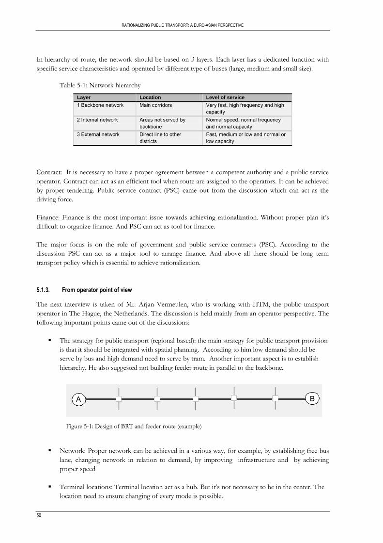
RATIONALIZING PUBLIC TRANSPORT: A EURO-ASIAN PERSPECTIVE
50
In hierarchy of route, the network should be based on 3 layers. Each layer has a dedicated function with
specific service characteristics and operated by different type of buses (large, medium and small size).
Table 5-1: Network hierarchy
Layer Location Level of service
1 Backbone network Main corridors Very fast, high frequency and high capacity
2 Internal network Areas not served by backbone
Normal speed, normal frequency and normal capacity
3 External network Direct line to other districts
Fast, medium or low and normal or low capacity
Contract: It is necessary to have a proper agreement between a competent authority and a public service
operator. Contract can act as an efficient tool when route are assigned to the operators. It can be achieved
by proper tendering. Public service contract (PSC) came out from the discussion which can act as the
driving force.
Finance: Finance is the most important issue towards achieving rationalization. Without proper plan it‟s
difficult to organize finance. And PSC can act as tool for finance.
The major focus is on the role of government and public service contracts (PSC). According to the
discussion PSC can act as a major tool to arrange finance. And above all there should be long term
transport policy which is essential to achieve rationalization.
5.1.3. From operator point of view
The next interview is taken of Mr. Arjan Vermeulen, who is working with HTM, the public transport
operator in The Hague, the Netherlands. The discussion is held mainly from an operator perspective. The
following important points came out of the discussions:
The strategy for public transport (regional based): the main strategy for public transport provision
is that it should be integrated with spatial planning. According to him low demand should be
serve by bus and high demand need to serve by tram. Another important aspect is to establish
hierarchy. He also suggested not building feeder route in parallel to the backbone.
A B
Figure 5-1: Design of BRT and feeder route (example)
Network: Proper network can be achieved in a various way, for example, by establishing free bus
lane, changing network in relation to demand, by improving infrastructure and by achieving
proper speed
Terminal locations: Terminal location act as a hub. But it‟s not necessary to be in the center. The
location need to ensure changing of every mode is possible.

RATIONALIZATION PUBLIC TRANSPORT: A EURO-ASIAN PERSPECTIVE
51
Organization: Proper organizational structure comprise of Government role, monitoring, fare
structure, subsidy and tender.
5.1.4. Translation of interviews into framework
Based on above three interviews, a framework for rationalizing public transport systems has been
developed. The ultimate aim is to develop a theoretical framework from scientific knowledge and expert‟s
interview.
This framework has been developed in several consecutive phases. Firstly the interviews are conducted
and the discussions are organized under main aspects of rationalization according to the experts own
views on main components of rationalization. The second step is to develop a framework from each of
the interviews. Finally, the three frameworks have been combined into one framework considering main
aspects of rationalization which are commonly came out from the discussion of the experts. After
combining these three expert‟s opinions, the framework has been derived that covered operational, policy
and operator perspectives (the process from experts interview has been demonstrated in Annex 3).
Network
Organization
System planning
Economics
Hierarchy
Separate bus lane
Terminal location
Government role
Fare structure
Regulating
Fare structure
Tender
BRT line
Spatial planning
PT demand
Infrastructure
Feeder
Economic viability
Scheduling
Dedicated route
CBD
Demand location
Frequency
Capacity
Network quality
Buses/hr
Occupancy
Quality
monitoring
Finance Subsidy
Network
Organization
Contract
Institutional framework
Hierarchy
Start from scratch
Terminal location
Government role
Fare structure
Regulation
Fare structure
Tender
Backbone
Route assign
tender
External
Law
Supervision
CBD
policy
licensing
PSC
monitoring
Finance Proper plan
Internal
Enforcement
Network
Organization
Scheduling
Institutional framework
Hierarchy
Free bus lane
Terminal location
Government role
Fare structure
Regulation
Fare structure
Tender
By demand
Minimum 4 times/hr
Feeder
Monitoring
Main line
Operational point of view Organizational point of view Operator point of view
Figure 5-2: Translation of interview
The ultimate framework mainly explores five main components of rationalization. Under these five main
components there are several sub components also mentioned which already discussed in this chapter.
Through framework of scientific knowledge, expert interviews and field visit explored the gap between
theory and practice if it exists. The overall theoretical framework of rationalization of PT planning
explored in chapter six.
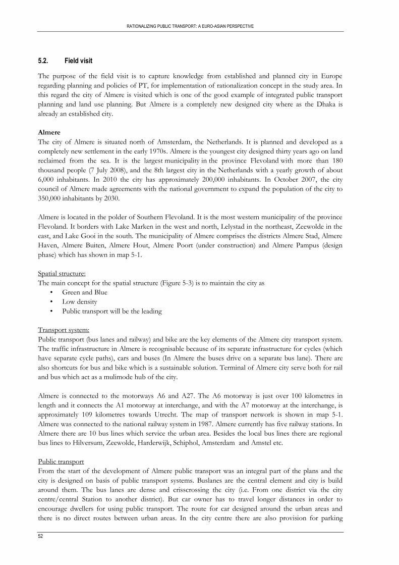
RATIONALIZING PUBLIC TRANSPORT: A EURO-ASIAN PERSPECTIVE
52
5.2. Field visit
The purpose of the field visit is to capture knowledge from established and planned city in Europe
regarding planning and policies of PT, for implementation of rationalization concept in the study area. In
this regard the city of Almere is visited which is one of the good example of integrated public transport
planning and land use planning. But Almere is a completely new designed city where as the Dhaka is
already an established city.
Almere
The city of Almere is situated north of Amsterdam, the Netherlands. It is planned and developed as a
completely new settlement in the early 1970s. Almere is the youngest city designed thirty years ago on land
reclaimed from the sea. It is the largest municipality in the province Flevoland with more than 180
thousand people (7 July 2008), and the 8th largest city in the Netherlands with a yearly growth of about
6,000 inhabitants. In 2010 the city has approximately 200,000 inhabitants. In October 2007, the city
council of Almere made agreements with the national government to expand the population of the city to
350,000 inhabitants by 2030.
Almere is located in the polder of Southern Flevoland. It is the most western municipality of the province
Flevoland. It borders with Lake Marken in the west and north, Lelystad in the northeast, Zeewolde in the
east, and Lake Gooi in the south. The municipality of Almere comprises the districts Almere Stad, Almere
Haven, Almere Buiten, Almere Hout, Almere Poort (under construction) and Almere Pampus (design
phase) which has shown in map 5-1.
Spatial structure:
The main concept for the spatial structure (Figure 5-3) is to maintain the city as
• Green and Blue
• Low density
• Public transport will be the leading
Transport system:
Public transport (bus lanes and railway) and bike are the key elements of the Almere city transport system.
The traffic infrastructure in Almere is recognisable because of its separate infrastructure for cycles (which
have separate cycle paths), cars and buses (In Almere the buses drive on a separate bus lane). There are
also shortcuts for bus and bike which is a sustainable solution. Terminal of Almere city serve both for rail
and bus which act as a mulimode hub of the city.
Almere is connected to the motorways A6 and A27. The A6 motorway is just over 100 kilometres in
length and it connects the A1 motorway at interchange, and with the A7 motorway at the interchange, is
approximately 109 kilometres towards Utrecht. The map of transport network is shown in map 5-1.
Almere was connected to the national railway system in 1987. Almere currently has five railway stations. In
Almere there are 10 bus lines which service the urban area. Besides the local bus lines there are regional
bus lines to Hilversum, Zeewolde, Harderwijk, Schiphol, Amsterdam and Amstel etc.
Public transport
From the start of the development of Almere public transport was an integral part of the plans and the
city is designed on basis of public transport systems. Buslanes are the central element and city is build
around them. The bus lanes are dense and crisscrossing the city (i.e. From one district via the city
centre/central Station to another district). But car owner has to travel longer distances in order to
encourage dwellers for using public transport. The route for car designed around the urban areas and
there is no direct routes between urban areas. In the city centre there are also provision for parking
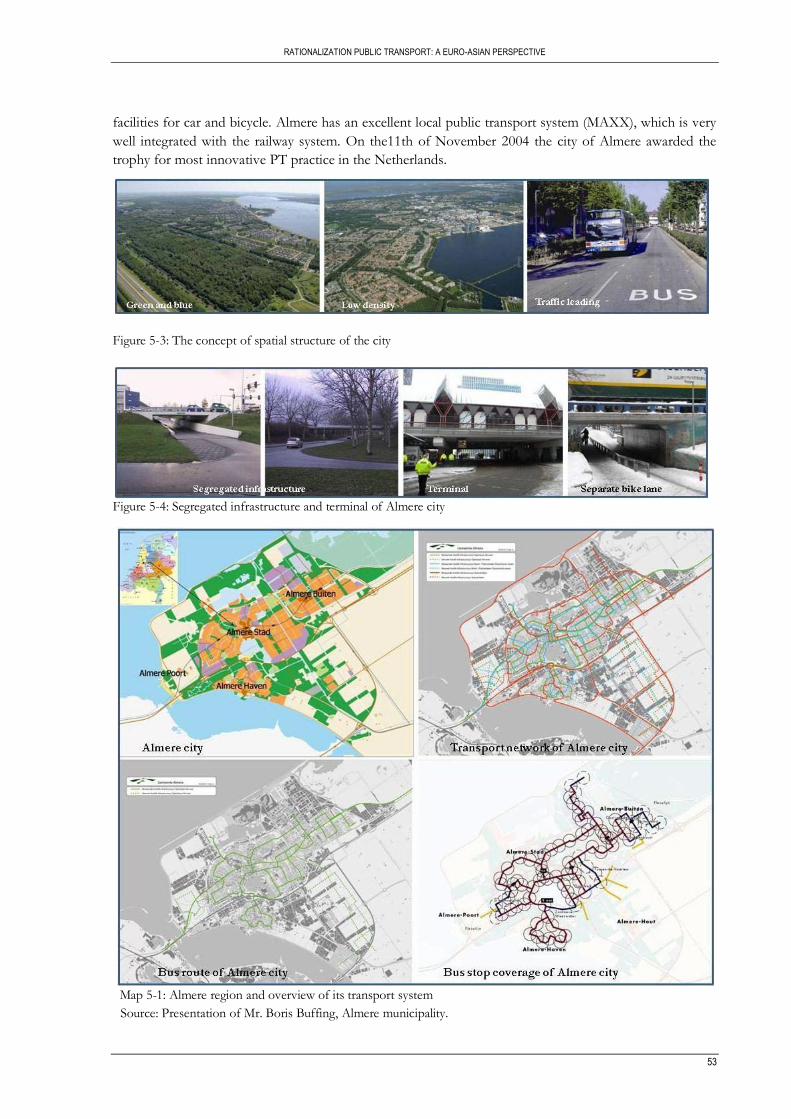
RATIONALIZATION PUBLIC TRANSPORT: A EURO-ASIAN PERSPECTIVE
53
facilities for car and bicycle. Almere has an excellent local public transport system (MAXX), which is very
well integrated with the railway system. On the11th of November 2004 the city of Almere awarded the
trophy for most innovative PT practice in the Netherlands.
Figure 5-3: The concept of spatial structure of the city
Figure 5-4: Segregated infrastructure and terminal of Almere city
Map 5-1: Almere region and overview of its transport system
Source: Presentation of Mr. Boris Buffing, Almere municipality.

RATIONALIZING PUBLIC TRANSPORT: A EURO-ASIAN PERSPECTIVE
54
Main features of the public bus system of Almere city are as follows:
• The public transport buses in Almere use an extensive network of dedicated bus lanes. The total
one way length is 105 km. The buses have priority at all intersections.
• The majority of houses and businesses are within 400 meters of a bus stop.
• The average speed of the bus system is 26 km per hour which comparable with light rail. One of
the aims of the Maxx-concept is to minimize boarding time in order to increase the average speed.
• The service has a high (7.5 to 10 minute) frequency six days a week.
• The rolling stock has a low floor and is very accessible for wheelchairs and baby carriages.
• Moreover, the buses are equipped with an information display, camera supervision and a system
for announcing stops.
• Customers pay the special Maxx tariff of 2 Euros with which they may travel 1.5 hours. There are
also multiple trip tickets available. Maxx has a so-called “open boarding regime”.
• Passengers can board through all available doors. For this purpose special sensors are installed
with which the doors can be opened from the outside by waiting passengers. In quiet hours, these
sensors are shut down for safety and security reasons; with passengers getting in at the front of
the vehicle.
• There are ticket validation machines inside the buses. Due to the open boarding regime, the
average speed of the buses has increased by 13 per cent to an average speed of 26 kilometers per
hour. Extra supervisors are deployed to ensure that all passengers buy a ticket.
Nowadays in Almere city almost 20% travels are by bus and within Almere there are almost no traffic
jams and no problems with pollution. Despite of this advantage there are some limitations also. The whole
segregation of infrastructure has some negative effect. The total segregation of bike/pedestrians, car and
bus are not safe enough especially during dark hours around tunnels (Figure 5-4: Separate bike lane).
5.3. Conclusion
From the above discussions of rationalization, based on scientific knowledge and expert‟s opinions, it is
quite clear that the main aspects of rationalization are to some extent similar. But after analysing the
expert‟s interview there are some points or sub aspects which are yet not documented. For example in
Vuchic theory there are hardly any discussions on establishing hierarchy and also on the importance of
terminal locations which according to planning practice are quite important aspects. Also about the
integration of transport policy and spatial planning are missing.

RATIONALIZATION PUBLIC TRANSPORT: A EURO-ASIAN PERSPECTIVE
55
6. THEORETICAL FRAMEWORK OF RATIONALIZATION
This chapter provides the theoretical framework of rationalization and its significance, as derived from
scientific knowledge, expert‟s opinions and a field visit. The chapter starts by describing the basic
requirements of public transport, the basic elements of PT planning strategy based on literature and
experts opinion. Finally it concludes with the theoretical framework of rationalization of PT planning.
6.1. Basic requirements for public transport
Public transport is vital for most cities in the world. Cities like Moscow, New York, Shanghai and Hong
Kong would look completely different if they would not have their extensive public transport systems.
Public transport provides mobility for the society, especially during rush hours when many citizens travel
from home to work or vice versa. Not only the large cities but also intermediate cities (roughly between
100,000 and 400,000) need to have a good working public transport system for healthy economic, social
and ecological circumstances. The main goal of public transport is to ensure:
Equitable mobility.
Economic development of urban areas;
An attractive alternative for private car user.
Based on the discussions in chapter four and five, specifically major considerations of PT planning in
European cities and the transit system requirements and experts opinion, come up with the following
basic requirements for public transport. By combining passenger, operator and community perspective
these basic requirements are set out.
Public transport should comply with the basic requirements that are explained in table 6-1.
Table 6-1: Basic requirements for PT
Attractive Safe Efficient Affordable Sustainable
Comfortable Safe vehicle Clear network hierarchy
Affordable for passengers
Environmentally sustainable
Reliable Safe infrastructure Efficient organisation and management
Affordable for operators
Socially sustainable
Fast Safe stops Competitive Affordable for municipality
Financially sustainable
Understandable Safe drivers Effective legalization
Attractive public transport: Comfortable, reliable, fast, understandable and integration are major five
aspects which can make public transport attractive. By modern vehicles, ensuring sufficient capacity and
seating availability public transport can be comfortable. Regular service and proper travel time can make
public transport reliable. High frequencies, segregated infrastructure, speed and direct connections make
public transport attractive. All these aspects of attractive public transport are summarized in table 6-2.

RATIONALIZING PUBLIC TRANSPORT: A EURO-ASIAN PERSPECTIVE
56
Table 6-2: Requirements of attractive PT
Attractive public transport
Comfortable Modern and attractive vehicles Sufficient capacity and seating availability
Reliable Services at regular intervals Reliable travel times
Fast High frequency Direct connections Commercial travel speed competitive with private cars Segregated infrastructure in busy city center Smooth transfers between lines
Understandable Logical route network User friendly Extensive passengers’ information at public transport stops, stations, internet and via mobile phone (call centre / SMS)
Integration Coordinated routes and timetables
Safe public transport: Public transport should be safe in terms of vehicle, infrastructure, bus stops, and
stations and also by ensuring proper trained driver. The ways to achieve safe public transport are
described below:
Table 6-3: Requirement of safe PT
Safe public transport
Safe vehicle Modern and safe vehicles meeting (inter)national safety standards Strict adherence to bus maintenance requirements
Safe infrastructure Well maintained roads Geometric design standards compatible with standard or large buses’ turning and dimensions
Safe stops Safe and comfortable stops Bus bays at important stops
Safe stations Well designed bus bays and parking areas to avoid conflicts between buses or with passengers Sheltered waiting areas for the passengers
Safe drivers Trained drivers Active safety management that monitor drivers’ safety records
Efficient public transport: To ensure efficient public transport need to establish clear network hierarchy,
proper organization and management, competitive market and sound finance mechanism.
Table 6-4: Requirement of effective PT
Efficient public transport
Clear network hierarchy Network design with clear distinction between route types. No “in-the-market” competition and only “for the market” competition. Vehicle technology and capacity compatible with the routes function. Well maintained roads.
Efficient organization and management
Professional public sector authority with capabilities to design efficient network structure and to procure services with tender services. Central control monitoring with real time dispatching and adjustment capabilities. Professional companies management with modern personnel and equipment procurement procedures. Regular surveys to identify passenger needs and demand.
Competitive Competitive environment aimed to get “value for money”.
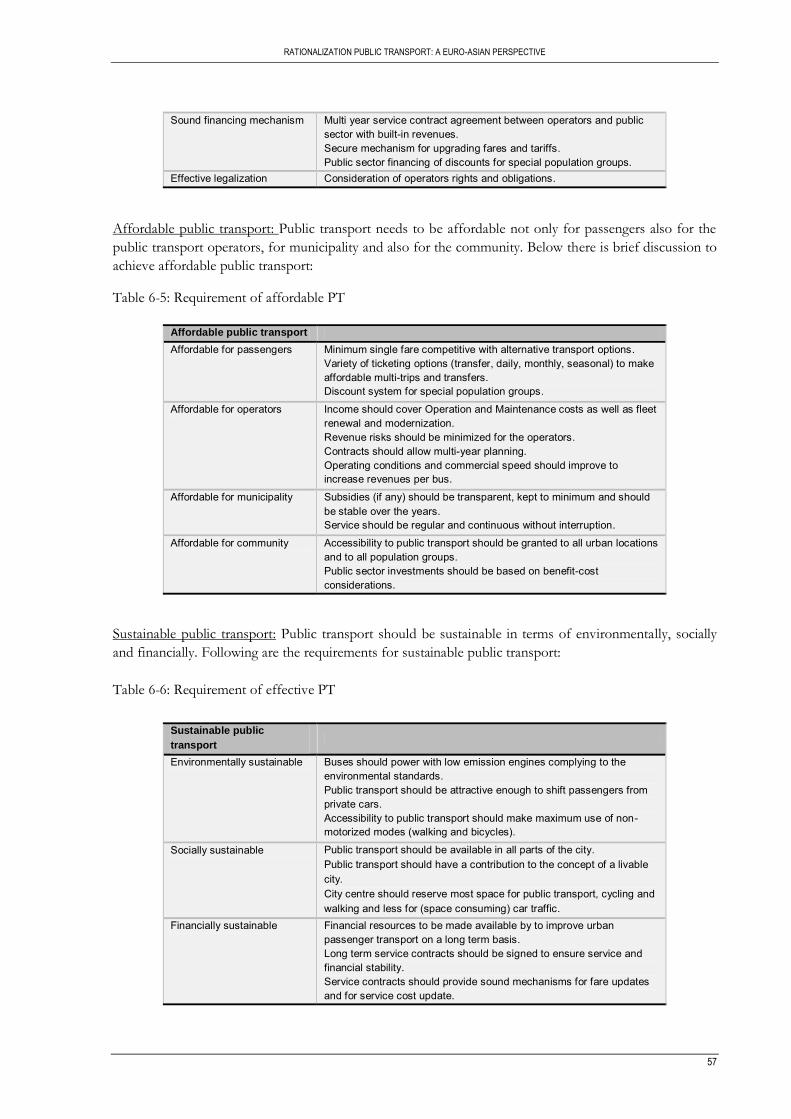
RATIONALIZATION PUBLIC TRANSPORT: A EURO-ASIAN PERSPECTIVE
57
Sound financing mechanism Multi year service contract agreement between operators and public sector with built-in revenues. Secure mechanism for upgrading fares and tariffs. Public sector financing of discounts for special population groups.
Effective legalization Consideration of operators rights and obligations.
Affordable public transport: Public transport needs to be affordable not only for passengers also for the
public transport operators, for municipality and also for the community. Below there is brief discussion to
achieve affordable public transport:
Table 6-5: Requirement of affordable PT
Affordable public transport
Affordable for passengers Minimum single fare competitive with alternative transport options. Variety of ticketing options (transfer, daily, monthly, seasonal) to make affordable multi-trips and transfers. Discount system for special population groups.
Affordable for operators Income should cover Operation and Maintenance costs as well as fleet renewal and modernization. Revenue risks should be minimized for the operators. Contracts should allow multi-year planning. Operating conditions and commercial speed should improve to increase revenues per bus.
Affordable for municipality Subsidies (if any) should be transparent, kept to minimum and should be stable over the years. Service should be regular and continuous without interruption.
Affordable for community Accessibility to public transport should be granted to all urban locations and to all population groups. Public sector investments should be based on benefit-cost considerations.
Sustainable public transport: Public transport should be sustainable in terms of environmentally, socially
and financially. Following are the requirements for sustainable public transport:
Table 6-6: Requirement of effective PT
Sustainable public
transport
Environmentally sustainable Buses should power with low emission engines complying to the environmental standards. Public transport should be attractive enough to shift passengers from private cars. Accessibility to public transport should make maximum use of non-motorized modes (walking and bicycles).
Socially sustainable Public transport should be available in all parts of the city. Public transport should have a contribution to the concept of a livable city. City centre should reserve most space for public transport, cycling and walking and less for (space consuming) car traffic.
Financially sustainable Financial resources to be made available by to improve urban passenger transport on a long term basis. Long term service contracts should be signed to ensure service and financial stability. Service contracts should provide sound mechanisms for fare updates and for service cost update.
RATIONALIZING PUBLIC TRANSPORT: A EURO-ASIAN PERSPECTIVE
58
While integrating scientific knowledge and expert‟s opinion it comes in front that, in literature different
components of rationalization discussed separately but not as categorized components of rationalization
where as in planning practice (expert‟s opinion) it is quite clear. Also in literature most of the planning
solutions are referred for the newly planned cities where as in expert‟s opinion especially in operational
point of view, the suggestions are mainly for the existing established cities.
6.2. A theoretical framework of rationalization
The ultimate aim is to develop a theoretical framework from scientific knowledge and expert‟s interview.
The main aspects of this framework are already discussed in chapter four and five. After combining
scientific knowledge, expert‟s opinion which mainly covers the operational, policy and operator
perspective and experience from field visit, a combined theoretical framework of rationalization has been
developed.
This framework mainly explores five main components of rationalization which are network, system
planning organization, institutional framework and finance. Under these components there are several sub
aspects also mentioned. Although all the aspects are closely connected but network and system planning
are closely interlinked whereas organization, institutional framework and finance are influence each other.
To get an efficient network it‟s necessary to establish hierarchy, separate way or dedicated route, ensure
proper terminals location and service provision. Already in chapter four and five different ways of
establishing hierarchy by categorizing routes are discussed according to backbone, feeder and also by
external or direct routes towards surroundings. Backbone network can be established by any form of mass
transit like BRT, LRT, and Metro; depends on city size and demand. Also backbone network can be
achieved by the combination of BRT, LRT and Metro. It effects the service provision in terms of
achieving enough capacity, by reducing travel time and by increasing speed. Also by designing separate
bus ways or dedicated bus lane can increase the service provision and act as an integral part of establishing
hierarchy. Terminal location plays a major role towards ensuring an efficient network. It can also play as a
hub where all types of modes interchange is possible.
System planning is another component of rationalization framework which is closely related to network. It
has three main sub aspects namely spatial planning, demand analysis and infrastructure. Spatial planning
and demand influence each other which in long run influence the network. Also proper infrastructure can
ensure efficient network. It is necessary to provide proper infrastructure in relation to spatial planning as
new land use always generate demand. So proper system planning will increase towards achieving the
efficient and effective network and vice versa.
Organization is one of major aspects of rationalization. This mainly consists of four sub aspects namely
government role, system integration, and management and involve of public sector. Government has
strong role in monitoring, licensing and providing policies. System integration and management also play
major role towards ensuring proper organizational set up. It is also necessary to involve public sector in
relation to achieve rationalization.
Tendering, enforcement and law are the sub aspects of institutional framework which is the fourth
component of rationalization. Strong enforcement, proper tendering and effective law ensure proper
institutional framework. Institutional framework is closely interlinked with organizational set up.
The final component is finance which has two sub aspects fare structure and subsidy. Fare structure plays
a major role. According EU planning practice subsidy is one of the important aspects for rationalization.
Proper plan can ensure the subsidy.

RATIONALIZATION PUBLIC TRANSPORT: A EURO-ASIAN PERSPECTIVE
59
Network
Organization
Institutional
framework
System planning
Finance
Hierarchy
Separate bus lane/
Dedicated route
Terminal location
Service provision
Government role
Fare structure
System integration
Tender
Subsidy
Law
Th
eo
reti
ca
l fr
am
ew
ork
of
rati
on
ali
za
tio
n
Monitor
Policy
Licensing
Management
Discount
Integrated
Structure
Spatial planning
Demand
Infrastructure
Involve of private
sector
Backbone
Internal
External
Capacity
Speed
Travel time
Figure 6-1: Theoretical framework of rationalization
6.3. Conclusion
The overall theoretical framework is explained in this chapter. This framework is derived from mainly two
aspects which are scientific knowledge and expert‟s opinion. This framework mainly explores five main
components of rationalization which are network, system planning, organization, institutional framework
and finance. All the components regarding the theoretical frameworks are closely connected and
interlinked with each other. In this chapter also discusses the basic requirements of public transport
system. Based on this theoretic framework, a proposal on rationalization of public transport system is
prepared for study area which is discussed in Chapter 7.


RATIONALIZATION PUBLIC TRANSPORT: A EURO-ASIAN PERSPECTIVE
61
7. IMPLEMENTATION AND EVALUATION OF THEORETICAL FRAMEWORK
The previous chapter resulted in a rationalization framework. This chapter describes the implementation
of this framework for Dhaka PT situation (focusing on routes and their categorization) and finally
concludes with the evaluation of the frameworks‟ network component and recommends policy guidelines.
7.1. Implementation of rationalization framework to study area, Dhaka
The public transportation system in Metropolitan Dhaka is not only performing below standard as
compared with other capital cities but it has also reached a crisis point that requires immediate attention.
An intensive effort is needed from all concerned to resolve the city‟s transportation problem. The overall
design of the public transport systems both public and private transport need to be re-planned and re-
constructed.
In the previous chapter the rationalization framework explores five main aspects of PT system design.
This framework mainly discussed five aspects and under every aspect there are several sub aspects also
mentioned. In the following sections implementations of these aspects and sub aspects of rationalization
framework are discussed in relation to study area. But due to the data and information limitations, not all
the sub aspects can be discussed.
In order to guide the implementation of framework in the study area, there should be a set of clearly
defined objectives. The following are the guiding objectives:-
(a) Develop an efficient public transport system.
(b) Strengthen institutional, policy and regulatory framework;
(c) Prepare long-term urban transport plan to cope with future growth of the city in coordination with
future land-use planning for the capital area; and
(d) Improve road safety and environment.
7.1.1. Network
According to the rationalization framework, towards a better and effective public transport the first and
most important aspect is to ensure an efficient and effective PT network. Towards this, the first step is to
establish hierarchy of routes. The highest hierarchy should have a separate lane or dedicated route. There
is a significant influence of service provision (that is ensuring capacity, proper speed and travel time) and
terminals location on achieving proper network. Below there is a brief discussion on these aspects to
implement in study area.
1. Establishing hierarchy of PT routes:
The network should have a certain logical hierarchy for PT routes. A new network and service concept
has designed consisting of 3 layers. Each layer has a dedicated function with specific service
characteristics. This hierarchy will be achieved by establishing backbone network, internal network and
external network in study area as already explained in table 5-1.
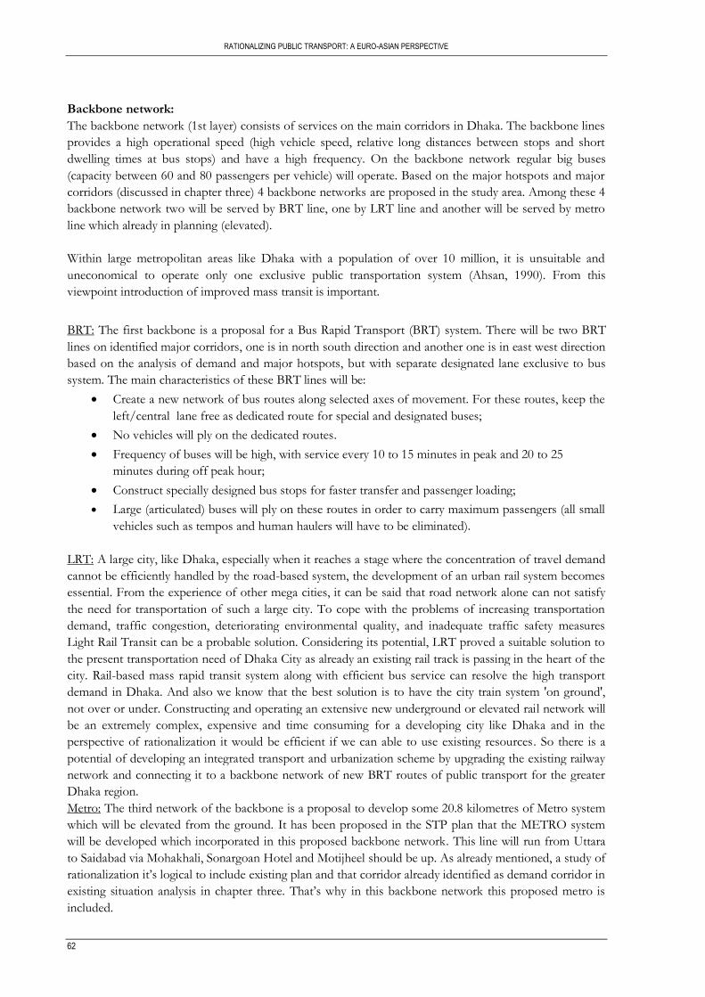
RATIONALIZING PUBLIC TRANSPORT: A EURO-ASIAN PERSPECTIVE
62
Backbone network:
The backbone network (1st layer) consists of services on the main corridors in Dhaka. The backbone lines
provides a high operational speed (high vehicle speed, relative long distances between stops and short
dwelling times at bus stops) and have a high frequency. On the backbone network regular big buses
(capacity between 60 and 80 passengers per vehicle) will operate. Based on the major hotspots and major
corridors (discussed in chapter three) 4 backbone networks are proposed in the study area. Among these 4
backbone network two will be served by BRT line, one by LRT line and another will be served by metro
line which already in planning (elevated).
Within large metropolitan areas like Dhaka with a population of over 10 million, it is unsuitable and
uneconomical to operate only one exclusive public transportation system (Ahsan, 1990). From this
viewpoint introduction of improved mass transit is important.
BRT: The first backbone is a proposal for a Bus Rapid Transport (BRT) system. There will be two BRT
lines on identified major corridors, one is in north south direction and another one is in east west direction
based on the analysis of demand and major hotspots, but with separate designated lane exclusive to bus
system. The main characteristics of these BRT lines will be:
Create a new network of bus routes along selected axes of movement. For these routes, keep the
left/central lane free as dedicated route for special and designated buses;
No vehicles will ply on the dedicated routes.
Frequency of buses will be high, with service every 10 to 15 minutes in peak and 20 to 25
minutes during off peak hour;
Construct specially designed bus stops for faster transfer and passenger loading;
Large (articulated) buses will ply on these routes in order to carry maximum passengers (all small
vehicles such as tempos and human haulers will have to be eliminated).
LRT: A large city, like Dhaka, especially when it reaches a stage where the concentration of travel demand
cannot be efficiently handled by the road-based system, the development of an urban rail system becomes
essential. From the experience of other mega cities, it can be said that road network alone can not satisfy
the need for transportation of such a large city. To cope with the problems of increasing transportation
demand, traffic congestion, deteriorating environmental quality, and inadequate traffic safety measures
Light Rail Transit can be a probable solution. Considering its potential, LRT proved a suitable solution to
the present transportation need of Dhaka City as already an existing rail track is passing in the heart of the
city. Rail-based mass rapid transit system along with efficient bus service can resolve the high transport
demand in Dhaka. And also we know that the best solution is to have the city train system 'on ground',
not over or under. Constructing and operating an extensive new underground or elevated rail network will
be an extremely complex, expensive and time consuming for a developing city like Dhaka and in the
perspective of rationalization it would be efficient if we can able to use existing resources. So there is a
potential of developing an integrated transport and urbanization scheme by upgrading the existing railway
network and connecting it to a backbone network of new BRT routes of public transport for the greater
Dhaka region.
Metro: The third network of the backbone is a proposal to develop some 20.8 kilometres of Metro system
which will be elevated from the ground. It has been proposed in the STP plan that the METRO system
will be developed which incorporated in this proposed backbone network. This line will run from Uttara
to Saidabad via Mohakhali, Sonargoan Hotel and Motijheel should be up. As already mentioned, a study of
rationalization it‟s logical to include existing plan and that corridor already identified as demand corridor in
existing situation analysis in chapter three. That‟s why in this backbone network this proposed metro is
included.

RATIONALIZATION PUBLIC TRANSPORT: A EURO-ASIAN PERSPECTIVE
63
Map 7-1: Proposed Backbone network
In the context of low income developing country, dedicated bus lanes and light rail transits seem to be the
most realistic solutions for the urban transportation problem of metropolitan Dhaka. Once the system is
in place, it is expected that people would not be interested to use their private cars anymore. The city and
the economy will get tremendous relief from the vehicle pressure and reduction of fuel related pollutants
respectively. The majority of the people could have easy access to them.
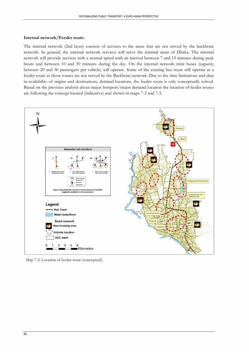
RATIONALIZING PUBLIC TRANSPORT: A EURO-ASIAN PERSPECTIVE
64
Internal network/Feeder route:
The internal network (2nd layer) consists of services to the areas that are not served by the backbone
network. In general, the internal network services will serve the internal areas of Dhaka. The internal
network will provide services with a normal speed with an interval between 7 and 15 minutes during peak
hours and between 10 and 30 minutes during the day. On the internal network mini buses (capacity
between 20 and 30 passengers per vehicle) will operate. Some of the existing bus route will operate as a
feeder route as those routes are not served by the Backbone network. Due to the time limitations and data
in-availability of origins and destinations, demand locations, the feeder route is only conceptually solved.
Based on the previous analysis about major hotspots/major demand location the location of feeder routes
are following the concept located (indicative) and shown in maps 7-2 and 7-3.
Map 7-2: Location of feeder route (conceptual).

RATIONALIZATION PUBLIC TRANSPORT: A EURO-ASIAN PERSPECTIVE
65
Map 7-3: Feeder route layout (option)
External network:
Geographically the location of Dhaka is in the centre of the country and there are three gateways
connecting the city with adjacent cities/villages/ as shown in map 7-4. As a result a lot of vehicle related
traffic passes through the city creating anonymous pressure on city roads. That‟s why it‟s really necessary
to differentiate these inter-district connections from city‟s own PT system. This external network (3rd
layer) consists of direct fast services to different towns in the Dhaka district. Distances of lines are much
longer than the internal network and depending on travel demand; frequencies will vary from 15-30
minutes in peak hour till 30-60 minutes during the day. Connections from the external network to the
backbone network can be made either on Saidabad bus terminal (for southern corridor) or for some lines

RATIONALIZING PUBLIC TRANSPORT: A EURO-ASIAN PERSPECTIVE
66
at the Gabtoli bus terminal (north western corridor). Outskirt connection from Dhaka is beyond the scope
of study and due to the data limitations it‟s not possible to show the proposed external network.
Map 7-4: Dhaka city map showing three gateways
Source: (Hoque & Choudhury, 2009)
2. Dedicated lanes/Separate bus ways:
Three aspects of geometric design viz. exclusive bus lane, location and design of bus stops, and non-
motorized vehicle lane are essential for system efficiency of BRT (Tiwari, 2006). Creating exclusive lanes
for buses minimizes conflicts with other vehicles and therefore improves bus movements. The basic
changes required in the proposed BRT lines include provision of a segregated bus way. Then, at least one
lane can be reserved for buses, while the other two can be for cars, and other motor vehicles. Exclusive
bus lanes can be provided either as curb-side lanes or central lanes physically segregated from the rest of
the traffic (Tiwari, 2006). The central lanes of a corridor have minimum conflict with turning vehicles or
slow moving vehicles. There is least probability that the volume of turning traffic from innermost lane will
come in conflict with it. Most successful BRT systems use the centre lanes (Hook, 2004). These central
lanes will be reserved for buses. In centrally placed bus lane layout the bus lanes for both directions are
separated by a median. Bus shelter can be on the right or on the left; but, putting station in the middle
consumes less road space and eases transfers (Hook, 2004). In the proposed BRT corridors it is possible
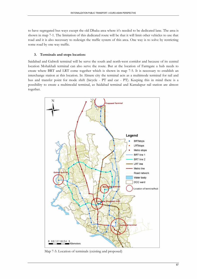
RATIONALIZATION PUBLIC TRANSPORT: A EURO-ASIAN PERSPECTIVE
67
to have segregated bus ways except the old Dhaka area where it‟s needed to be dedicated lane. The area is
shown in map 7-1. The limitation of this dedicated route will be that it will limit other vehicles to use that
road and it is also necessary to redesign the traffic system of this area. One way is to solve by restricting
some road by one way traffic.
3. Terminals and stops location:
Saidabad and Gabtoli terminal will be serve the south and north-west corridor and because of its central
location Mohakhali terminal can also serve the route. But at the location of Farmgate a hub needs to
create where BRT and LRT come together which is shown in map 7-5. It is necessary to establish an
interchange station at this location. In Almere city the terminal acts as a multimode terminal for rail and
bus and transfer point for mode shift (bicycle - PT and car - PT). Keeping this in mind there is a
possibility to create a multimodal terminal, as Saidabad terminal and Kamalapur rail station are almost
together.
Map 7-5: Location of terminals (existing and proposed)
RATIONALIZING PUBLIC TRANSPORT: A EURO-ASIAN PERSPECTIVE
68
From the discussion in chapter four, the standard spacing for BRT stops vary from 0.5km to 2 km. In the
proposed two BRT lines, the stops need to be located accordingly. Only a few existing stops can be
adapted but they also need some modifications (permanent structure, sitting facilities, information display
et.) and better facilities. Leading for the locations of the stops are the potential demand at those like a new
residential area, a location of a major facilities. So BRT stop spacing will not be always within 500 meter,
varies from 500 meter to 1.5 km. Bus stops need to be located at designated points only on the major
roads, with locations for boarding and alighting passengers.
For the proposed LRT the existing railway stations at Airport, Cantonment, Banani, Tejgaon, Kamalapur
must be expanded to function as multimodal exchange nodes. New such stations will have to be
constructed at the intersections of key roads and railway tracks at Mohakhali, Maghbazar, Panthapath and
Rampura Road.
7.1.2. System planning
Satellite cities are planned after carefully analyzing the present and future land use patterns and density,
ecosystems, utility and road infrastructure, presence of growth magnets such as industry, commerce,
institutional facilities, other urban amenities, and travelling time from key urban nodes. The integration of
transportation planning and land use planning in the context of the development of metropolitan Dhaka is
critical. The only realistic approach for the successful control of growth of development involves an active
commitment to policies involving transportation and land use planning. It is essential to recognize that the
size, growth rate and distribution of the density of metropolitan Dhaka have a crucial impact on the
dependence on transit. Land use planning and transportation planning interact between themselves to
determine development patterns. The two are so interconnected that they need to be considered
simultaneously. To achieve integration between these two it is necessary to create a unified authority that
will be responsible for the planning of both land use and transportation systems whereas the two
functions are currently separated. But the creation of a new authority will not be enough; also most
essentially needed is the political will and determination of the government.
7.1.3. Organization
Plan, program, and finance and implement such an important transportation system would need an
effective organizational set up. A good organizational set up can only be possible by strong government
role. Government should play a major role on monitoring, implementing policy and licensing as well as
need to monitor fare structure also. Government need to introduce policies on congestion pricing system
for specific areas for example Motijheel, Gulshan, Farmgate area, in order to control vehicle traffic at
specific hours of the day. The Government should revise the present system of vehicle registration in
order to eliminate the possibility of vehicles which are non-roadworthy obtaining a certificate to operate.
The Government should encourage the private sector to establish trained technicians to undertake the
vehicle testing program under license from the BRTA and need to review the existing system of issuance
of driving licenses. The Government needs to ensure that the drivers are trained, skilful, and aware of
traffic rules and medically fit to obtain a driving license. Computerise the parking violation records of
drivers and cars and introduce demerit penalty point system both for car and drivers.
System integration is important in terms of physical facilities e.g. terminals, exclusive bus lanes, ticketing,
infrastructure, parking and services e.g. network structure, schedule coordination. The greatest efficiencies
in operating transportation systems are achieved when different modes can act together whereas in Dhaka
the existing modes and sub modes act independently. The systems need to be planned so that all modes of
transport are integrated. There should be proper integration between all modes of backbone network and

RATIONALIZATION PUBLIC TRANSPORT: A EURO-ASIAN PERSPECTIVE
69
also with the backbone to the feeder in terms of fare integration, scheduling and also by creating a
common hub. The new systems will need to use whatever resources they have available in order to
enhance the existing services and to provide for increasing demand in the future.
Involve of private sector has an important role on organizational issue. Developing city like Dhaka it is
very necessary to have proper public private partnership. There are many advantages possible to gain by
involving private sector in the provisions of infrastructure and operations.
7.1.4. Institutional framework
The institutional capacity is known to be weak in the Dhaka Metropolitan Area, so it is important to
ensure that the enabling legislation for the executing agencies is enacted, lines of responsibility are clearly
defined and key staff appointments are made. There is a need to ensure that the current legislative
conditions are suitable for the encouragement of private sector investment. There will need to be an
independent review of current laws to ensure fairness on behalf of the private investor and protection for
the Government. The Government will should provide an open and transparent bidding procedure to
create fare competition within the bidding procedures.
In the absence of a properly maintained database, the authorities in Dhaka face another special problem in
respect of the assessment of actual number of registered motor vehicles and the identification of
ownership of these vehicles. As a result the law enforcing authority finds it difficult to locate and penalize
the owners and drivers of the vehicles which violate the traffic rules. The Government need to provide
the funds and other measures which will be needed to establish and maintain an up to date data base of
both vehicles and drivers. The data base will be managed by BRTA but will be accessible to law enforcing
agencies and safety engineers.
7.1.5. Finance
This new system will require investment in infrastructure to improve the existing roads, provide stations
and fare collection gates and equipment. In order to finance the implementation of recommended
backbone network required for the development of Metropolitan Dhaka, there are a range of possible
options including creating a user charges system and providing equitable subsidies in the right manner and
at as low a level as possible. There is a need to encourage loan financing from major international
agencies. The private sector will also need to play a vital role in the promotion of private public
partnerships.
The program could be run as a totally public sector venture or as joint public and private sector initiative.
The joint public sector -private sector initiatives could include majority contributions from a donor
agency, central government, City government to say 60 per cent to 75 per cent of the cost of the program.
The privatization of public transport has moderated the concentration of market structure and has lead to
improved frequencies and service levels in many European countries.
There is a need to introduce some form of easier fare structure in Dhaka city. This will not be easy under
this existing weak institutional framework. An innovative but easily understandable mechanism need to be
developed for the integration of fares between different type of backbone and feeder and also to develop
the provision of a common ticketing system to allow free movement between different modes. This is also
necessary to apply different strategies like discount fare for senior citizen, child etc. The fare structure will
take account the length of trip and the type of service provided. Also the fare structure needs to be revised

RATIONALIZING PUBLIC TRANSPORT: A EURO-ASIAN PERSPECTIVE
70
periodically to adjust for justifiable cost increases. Government need to take proper initiative to maintain
this and to ensure an equitable fare structure for passengers.
7.2. Evaluation of rationalization framework
In the previous section the implementation of framework in Dhaka is discussed, though it‟s not yet
established that this framework specifically the hierarchy of network will improve the existing situation or
not. To come up with this conclusion it‟s necessary to evaluate the network. But as already mentioned due
to the limitations of data availability it‟s not possible to assess the backbone and feeder network both. In
spite of this limitation it is attempted to evaluate the proposed (backbone) network on the base of a few
indicators.
1. Key features of proposed backbone network:
The key features of the proposed backbone network summarized in table 7-1. It is mainly derived from
the table 4-1 in chapter four.
Table 7-1: Key features of proposed Backbone network
Passenger Proposed backbone network
BRT LRT Metro (source: JICA)
Segregation Segregation / dedicated
lane Existing track Elevated
Space requirement 1 lane from existing road 1 or 2 lanes from existing
track Little impact on existing
road Public transit integration
Integrated with feeder & Para transit
Integrated with BRT stops, feeder & Para transit
Integrated with BRT stops, feeder & Para transit
Implementation time Short Medium Long
2. Access to CBD:
Access is the process associated with getting to and departing from the stops or stations. It is important
that transport services are efficient and reliable as compared with an acceptable level of accessibility to
transport facilities. Most public transport users access bus stops by walking, particularly in urban areas.
Such access is typically perceived in spatial terms as the physical proximity to transit stops or stations. The
significance of access is that the more people that reside and/or are employed in close proximity to transit,
the greater the likelihood that the service will be used (Murray et al, 1998). Actually, accessibility to transit
is a critical issue from a point of view both of sustainable mobility and of sustainable accessibility (Javier
Gutierrez, 2008).
As the city is growing, residential areas started to develop outside the CBD. People tend to live outside
city center and commute daily to the CBD for work. Using a bus system to commute is expected to
reduce the traffic volume on main roads. One of the indicators to analyze the accessibility to the CBD is
the travel time from each bus stop to the CBD. In this analysis three CBD‟s are defined, one is Motijheel
area which is the main commercial centre of the city, second is Framgate area which is the second
commercial centre of the city and third is Gulshan area which is newly developed commercial centre. The
world average commuting time is 40 minutes, one way for work. Here 30 to 45 minute is used as threshold
to define how long commuting time should take place. Travelling within this timeframe is regarded. It is
assumed that all people work in one of the Central Business Districts (CBD). The analysis is execute
sequentially, first using the existing bus then followed by adding one by one the backbone network (one
BRT, LRT, two BRT and finally with MRT) to see the effect of the additions gradually (Map 7-6). In
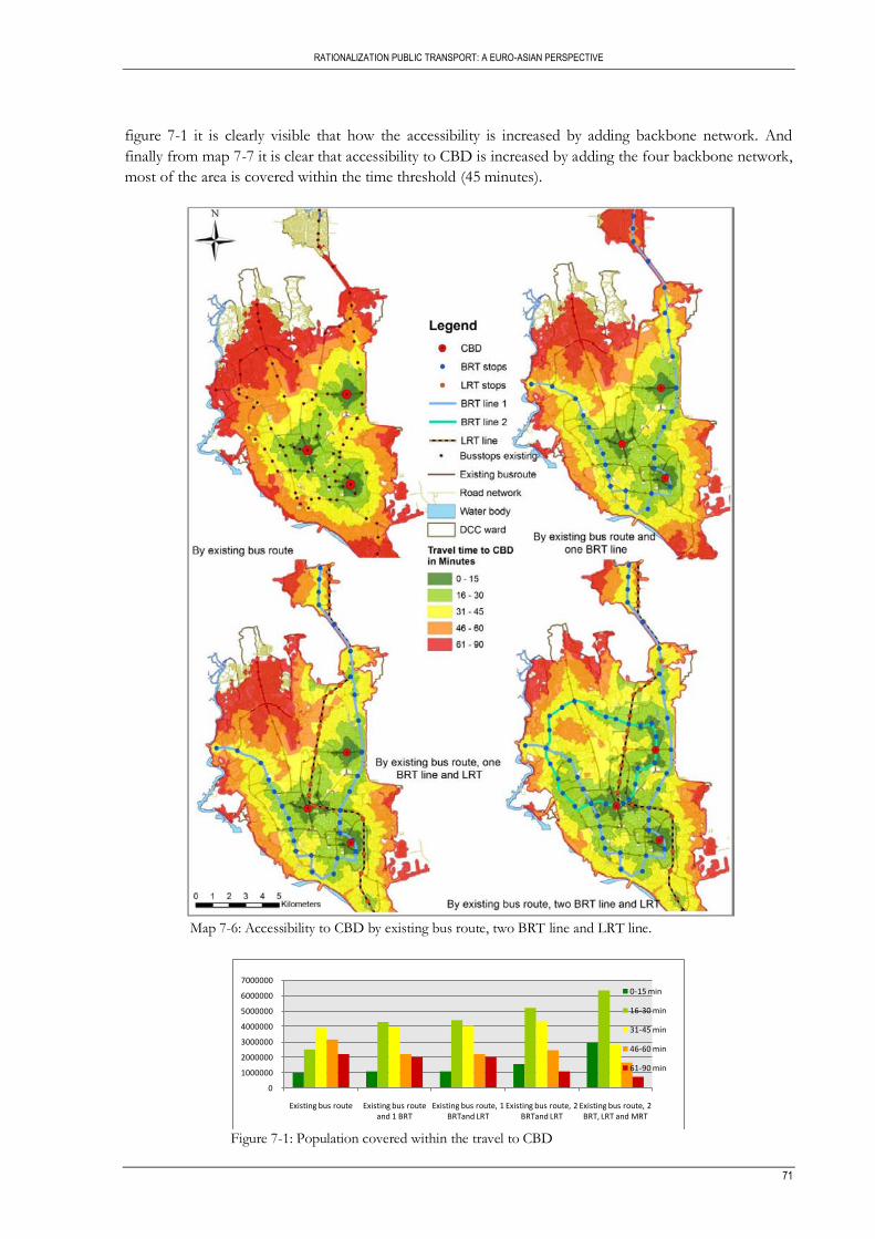
RATIONALIZATION PUBLIC TRANSPORT: A EURO-ASIAN PERSPECTIVE
71
figure 7-1 it is clearly visible that how the accessibility is increased by adding backbone network. And
finally from map 7-7 it is clear that accessibility to CBD is increased by adding the four backbone network,
most of the area is covered within the time threshold (45 minutes).
Map 7-6: Accessibility to CBD by existing bus route, two BRT line and LRT line.
Figure 7-1: Population covered within the travel to CBD
0
1000000
2000000
3000000
4000000
5000000
6000000
7000000
Existing bus route Existing bus route and 1 BRT
Existing bus route, 1 BRTand LRT
Existing bus route, 2 BRTand LRT
Existing bus route, 2 BRT, LRT and MRT
0-15 min
16-30 min
31-45 min
46-60 min
61-90 min

RATIONALIZING PUBLIC TRANSPORT: A EURO-ASIAN PERSPECTIVE
72
Map 7-7: Accessibility to CBD by backbone network
The similar analysis but based on industrial area, major government health facilities and major institutions
has been executed and are shown in Annex 4.
3. Service provision of existing bus route and proposed backbone network:
Service provision of existing bus route and proposed backbone network are summarized in table 7-2.
Three main characteristics that are travel speed, capacity and frequency, of existing bus route and
proposed backbone network are compared in this table.

RATIONALIZATION PUBLIC TRANSPORT: A EURO-ASIAN PERSPECTIVE
73
Table 7-2: Service provision of existing bus route and proposed backbone network
Characteristics Existing bus Proposed backbone network
BRT LRT Metro (source:JICA)
Travel speed 8 Km/hr 15 Km/hr 30 Km/hr 35 Km/hr Capacity (person) 30 to 45 60 500 to 1000 1778
Frequency 15 to 30 min (No
defined frequency) 10 – 15 min (peak hr) 20 – 25 min (off peak)
10 – 15 min (peak hr) 20 – 25 min (off peak)
3 min 20 seconds
7.3. Some policy guidelines and recommendations
In the expert‟s interview and also in European planning considerations, beside main components of
rationalization, there is several policy guidelines also provided. Considering experts critical comments and
also by reviewing documents regarding policy issues in study area, below there are few policy guide lines
and recommendations are provided towards achieving rationalized public transport system in Dhaka city.
1. Rationalise and harmonise the existing private sector buses into a number of limited companies
and allocate major routes to one of these different companies. Each route will be served by only
one company under a strictly set of rules and regulations. These would include number and types
of buses to be used on each routes, frequencies of operation, fares to be charged, etc. No other
buses or other companies will be allowed to ply on the designated routes.
2. The Government needs to implement a policy that removes the inefficient competition between
modes.
3. The Government should identify those areas of the city and the expanded development where
there will be a policy of emphasizing public transport access over private vehicle access.
4. Parking control should be the responsibility of the municipalities who will administer it through a
central parking control office. The office will retain its own staff and will employ parking wardens
to monitor space usage and issue tickets to violators. It is preferred that this aspect be undertaken
by the private sector and the Government will enact such rules as will make this possible. And
also need to provide and build as many parking-only structures (not mixed with other commercial
uses) as possible on all major arterial roads of the city.
5. There should be investigate means whereby subsidies can be allocated to the poor and needy in
order to make the transportation system affordable to all. Public transport of all kinds need to be
planned and designed or adapted so as to provide some facilities in the vehicles so that disabled
persons can access the vehicles and ride on them in comfort. The bus stations, terminals, railway
stations and motor launch landing stations will be re-planned to provide proper facilities for
disabled persons so that they do not encounter any impedance to movement.
6. Non-motorized transport will be prevented from operating on many sections of arterial highways
and especially at intersections. Rickshaws will be encouraged and assisted to ply on the lanes and
narrow roads to serve local neighbourhood demands and to provide feeder services from the
neighbourhoods to the main line rapid transit stops.
7. Bicycles need to be recognized as a mode of transport and separate lanes and crossings will be
provided within the city in order to make bicycle journeys safe and pleasant.

RATIONALIZING PUBLIC TRANSPORT: A EURO-ASIAN PERSPECTIVE
74
8. The Government need to enact a pedestrian policy to ensure the construction of properly
designed and continuous pedestrians with well-defined and maintained pedestrian routes in the
city, the provision of pedestrian crossing facilities giving the pedestrian priority over all other
traffic and the prohibition of unauthorised encroachment on the footpath by street vendors and
others.
9. The Government will initiate a comprehensive review of the existing laws and regulations as they
apply to private sector investments and will amend the laws such that they provide equitable ways
to enter into contracts between the parties.
The formulation of the most efficient plan and organizational set up will not be enough, is most essentially
needed is the political will and determination of the Government.
RATIONALIZATION PUBLIC TRANSPORT: A EURO-ASIAN PERSPECTIVE
75
8. CONCLUSION AND RECOMMENDATION
The objective of this chapter is to conclude the study and give recommendations. It is composed in three
main sections. First, conclusive remarks from the scope of study are given. Second the limitation of
achieving answers through analysis of all research questions is given. Finally recommendations are given
for further research from this study.
8.1. Conclusion
In drawing conclusion of this study, the research objective which is to study rationalization of public
transport; particularly public transport system design (routes and their categorization) in Dhaka,
Bangladesh, based on European public transport planning tradition and best practices is evaluated against
the findings and the observation.
Analyzing existing public transport situation of Dhaka city.
Dhaka is over densely populated city and its transport system is based on mainly road systems and it‟s
related to the traffic congestion and traffic management. The study shows that current public bus
provision was inadequate in relation to the demand. The present bus services (operated under as many as
750 individual ownerships) provide inefficient, unproductive, and unsafe level of services. Long waiting,
delay on plying, overloading, discomfort, and long walking distance from the residence/work place to bus
stoppages are some of the obvious problems that confront the users in their daily life. In peak hours they
very often load and unload in unspecified stops.
The real hindrance to smooth traffic as experts look at it does not lie in inadequate roads. Dhaka‟s
unplanned growth, a Dhaka-centric development of the country, the lack of east-west connecting roads,
unplanned construction inside the city, increased number of private transports, the lack of mass transit are
some of the contributory factors to these problem. At the same time the poor traffic management,
increasing number of rickshaws, lack of parking space and pedestrian walkways and reluctance to use of
foot over-bridge make travelling more difficult on the streets.
Also transport service in Dhaka has several deficiencies resulting from a combination of factors - physical,
developmental and institutional-cum-policy framework-related which lead to lower efficiency, higher
transport costs, longer waiting & travel time, discomfort and more significantly, “transport unreliability”
with major adverse consequence for the economy & environment. Rapid population growth, the absence
of planning control and poor economic conditions has contributed to the lack of organization on the
public rights-of-way. There is also a high level of operation disorder, which significantly diminishes the
efficiency and effectiveness of the existing transport systems.
Derive a theoretical framework from European scientific knowledge, planning practices and
example of European PT planning
By integrating scientific knowledge and discussions with European PT planning experts and an example of
PT planning, a theoretical framework on public transport rationalization is derived. This framework is
mainly captured from main two aspects which are scientific knowledge and expert‟s opinion through
RATIONALIZING PUBLIC TRANSPORT: A EURO-ASIAN PERSPECTIVE
76
interviews. This framework explores five main components of rationalization which are network, system
planning, organization, institutional framework and finance. All about the components regarding the
theoretical frameworks are closely connected and interlinked with each other.
From the scientific knowledge and expert‟s opinion it is quite clear that the main aspects of rationalization
to some extent are similar. But after analyzing expert‟s interview it has confronted that there are some
points or sub aspects which yet not documented. For example in Vuchic theory there are hardly any
discussions on establishing hierarchy and also on the importance of terminal locations which according to
planning practices are quite important aspects. Also about the integration of transport policy and spatial
planning are missing.
Establish this theoretical framework to Dhaka and draw planning and policy lessons.
After analyzing the existing situation it is clear that without a collaborative Mass Rapid Transport (MRT)
system the roads of Dhaka City will not be able to cope with the growing vehicles and expanded
passengers in the near future and the whole transportation system will collapse. So establishing the
theoretical framework where one of the major components is to ensure proper network by proper mass
rapid transit system is one way to solution the existing PT problem of Dhaka city. An integrated transport
scheme with BRT, LRT and metro to achieve hierarchy are already discussed in the previous chapter along
with the other components of theoretical framework. This will be two BRT lines on grade on existing
roads, but with separate designated lane exclusive to bus system. The existing railway stations and road
intersections at Tongi, Airport, Cantonment, Banani, Tejgaon, Kamalapur and Naranyanganj must be
expanded and rebuilt to function as multimodal exchange nodes. New such stations will have to be built at
the intersections of the key roads and railway tracks at Mohakhali, Maghbazar, Panthapath and Rampura
Road. Also feeder route need to integrate with the backbone system.
To overcome these increasing transportation burdens and to meet the transport needs of residents and to
promote desirable patterns of land use in Greater Dhaka over the next decades it is necessary to change
the existing policies. However, organizational supports and infrastructure development needed to meet the
demand of the mobility of the urban dwellers.
Establishment of this theoretical framework (chapter-7) to the study area are shown in this study which
will be useful to transportation planners, urban planner and policy makers in development of present PT
crisis and congestion of Dhaka city. Hopefully, hierarchy of routes and future proposed feeder access
accordingly will help to PT Planner and experts to influence the performance of public transportation
systems of Dhaka.
8.2. Study limitation
In the course of this research, some limitations are encountered:
Limitation on the existing situation analysis of the study area
The main limitation of this research regarding the analysis of the study area is the reliance on secondary
data and the inability to commence fieldwork in the study area, hence its not possible to check all data
correct or not. Since it is not possible to conduct an extensive survey in study area required for this study,
in the analysis it is necessary to rely on assumption and own knowledge. Although the researcher lives in
the study area it is quite impossible to have complete understanding and information about the entire
study area.
RATIONALIZATION PUBLIC TRANSPORT: A EURO-ASIAN PERSPECTIVE
77
Another limitation is the lack of spatial data covering the entire area of study which limits the scope of the
spatial analysis and a better understanding of existing situation of study area. Also regarding data
limitations, the data used for DCC is in GIS format but the population information used in analysis is
collected from paper sources. There is a slight difference in ward sizes used in GIS format vs ward sizes
collected from paper sources and keeping this in mind the further analysis is carried out.
As data and information collected from relevant organizations and published reports, many of the relevant
organizations and reports show the different figure of the same data for the same period. Therefore, some
of the data are incorporated based on assumption. Also data that have been used in this report from
different sources may have some inaccuracies. Sometimes they are not trustworthy like data have been
used from the internet sources (website), which may not be very reliable. These may lead to inaccuracies in
analysis. Sufficient updated data are not available for all priority issues and most of the data are used not
recent data.
Limitation on the theoretical framework approach
The theoretical framework is mainly based on scientific knowledge, expert‟s opinion and one of the
examples of EU planning practice. In this regard there are also few limitations, in capturing scientific
knowledge several documents are analysed but the framework mainly derived from Vuchics book which
mainly covered operational aspects. There are also few guide lines regarding planning issues but policy
guidelines are missing. Regarding experts interview it is initialized to cover all the expertise of PT planning
including operational, organizational, institutional and operator point of views. But due to expert‟s
unavailability and time limitations it is not possible to cover academician‟s points of view. Also another
limitation is about one of the example of European PT planning practices. Bearing in mind that the city
neither in same size nor generate same demand the analysis is carried out.
Limitation on the assessing the framework
Due to data limitation only the first component of framework implemented and evaluated in the study
area, in the rest of the components suggested guidelines but not implemented. Also the theoretical
framework implemented in the study area could not be assessed quantitatively and qualitatively due to lack
of data for doing so. This has been identified as a recommendation for future research.
8.3. Further research
This thesis reflects an initial step to the development of a theoretical framework to rationalize transport
system from European knowledge and practice and how to implement this framework in a developing city
like Dhaka with various constraints of land use and transport development. However further research in
this field is required.
Firstly there is an emerging need to analyse existing PT situation of the study area with a detail survey
which is able to integrate other factors within its analysis. The existing situation analysis used for this study
had a lot of limitation in term of data on cost (travel cost, fare cost, reliability of mode, safety and travel
information).
Secondly further study is required in defining the theoretical framework to be able to capture
rationalization in public transport planning. Further study can be done aimed at revealing consequences of
theoretical framework. Further study can focus on capturing expert‟s opinion, to cover all the aspects of
PT planning and also increase the number of expert‟s interview.
RATIONALIZING PUBLIC TRANSPORT: A EURO-ASIAN PERSPECTIVE
78
Thirdly the implementation of framework needs to be evaluated both qualitatively and quantitatively. Also
in this study the entire population is treated as equal, no competition is considered in term of education
and income level. Evaluating accessibility by taking into account the diversity in the socio-economic
structure of the society would result in more accurate results.
Finally in this research, while implementing the framework in Dhaka the cost benefit issue are not
included in the analysis due to the limitation of data. Further study can be done by considering this issue.
79
LIST OF REFERENCES
Ahsan, H. M. (1990). A Study of Mass Transit in Metropolitan Dhaka. BUET, Dhaka. Alterkawi, M. M. (2006). A Computer Simulation Analysis for Optimizing Bus Stops Spacing: The Case of
Riyadh, Saudi Arabia. Habitat International, 30(3), 500-508. Amin, M. S. R., Rahman, M. M., Uddin, M. Z., & Maniruzzaman, K. M. (2005). State of Public
Transport:An Analysis of Bus Routes and Stoppages of Dhaka City. Jahangirnagar Planning Review,, 3, 93-104.
Ammons, D. N. (2001). Municipal Benchmarks: Assessing Local Performance and Establishing Community Standards (2nd ed.): Thousand Oaks: Sage.
Armstrong-Wright et al. (1987). Bus services: Reducing cost, Raising standards: The world bank. Badami, M. G. (2005). The urban transport challenge in India - Considerations, implications and strategies.
International Development Planning Review, 27(2), 169-194. Badami, M. G., & Haider, M. (2007). An Analysis of Public Bus Transit Performance in Indian Cities.
Transportation Research Part A: Policy and Practice 41(10), 961-981. Banister, D. (2008). The Sustainable Mobility Paradigm. Transport Policy, 15(2), 73-80. Barter, P., & Raad, T. (2000). TAKING STEPS: A community action guide to people-centred, equitable and
sustainable transport: The SUSTRAN network. BBS. (2001). Statistical Year Book of Bangladesh, : Dhaka Reproduction Documentation and Publication
Wing, BBS. BBS. (2008). Statistical Year Book of Bangladesh: Dhaka Reproduction Documentation and Publication Wing,
BBS. BCAS. (2005). Dhaka City State of Environment: 2005: Report for Department of Environment, Ministry of
Environment and Forests. Beirão, G., & SarsfieldCabral, J. A. (2007). Understanding Attitudes towards Public Transport and Private
Car: A Qualitative Study. Transport Policy 14(6), 478-489. BRTA. (2002). Statistical List of Route Permit of Bus and Minibus in Dhaka City. Dhaka: Bangladesh Road
Transport. Button, K., & D. Hensher. (2001). Handbooks in transport 3: Handbook of transport systems and traffic
control. DCC. (2001). “Ward Details”: Annual Report of Dhaka City Corporation. DCC. (2007). Dhaka Profile: City Growth- Area and Population. from
http://www.dhakacity.org/html/dhaka_profile.html DDC. (1998). Dhaka Urban Transport Plan Phase II Consultancy Draft Final Report (Volume III): Environmental
Action Plan (EAP): Development Design Consultants (DDC) and Mott MacDonald and PPK prepared for the Ministry of Transport, Government of Bangladesh.
DDC. (1998). Dhaka Urban Transport Plan Phase II Consultancy Draft Final Report (Volume III): Environmental Action Plan (EAP): Development Design Consultants (DDC) and Mott MacDonald and PPK prepared for the Ministry of Transport, Government of Bangladesh.
Demetsky, M. J., & Lin, B. (1982). “Bus Stop Location and Design.”. Transportation Engineering Journal of ASCE, 108, , 313–327.
DITS. (1994). “Dhaka Integrated Transport System (DITS)”. Dhaka: Dhaka Transport Coordination Board (DTCB).
DMDP. (1995). Dhaka Structure Plan 1995-2015: Dhaka Metropolitan Development Plan, RAJUK. DUTP- II. (1998). Draft Final Report, . Dhaka.: Prepared by PPK, Mot MacDonald and Development
Design Consultant (DDC), . DUTP. (1998). Draft Final Report, Prepared by PPK. Dhaka: Mot MacDonald and Development Design
Consultant (DDC), . ECMT. (2004). Improving access to public transport. Eppell, V. A. T., J. M. Bunker, & et al. (2001). A four level road hierarchy for network planning and management.
Paper presented at the 20th ARRB Conference, Melbourne. Furth, P. G., & A.B. Rahbee. (2000). “Optimal Bus Stop Spacing Through Dynamic Programming and Geographic Modeling.”. Transportation Research Record, 1731, 15-22. GB50220-95. (1995). Code for Transport Planning on Urban Road. Beijing: Ministry of Construction of the
People's Republic of China. Gutierrez, J., & J. C. Garcia-Palomares. (2008). Distance-measure impacts on the calculation of transport
service area using GIS. Environmental and Planning B : Planning and Design 2008(35), 480-503.

80
Gwilliam, K. M. (2002). Cities on the Move: A World Bank Urban Transport Strategy Review. Washington D.C., : World Bank Publications.
Handy, S. L., & Niemeier, D. A. (1997). Measuring accessibility: an explanation of issues and alternatives. Environment and Planning A, 29(7), 1175-1194.
Hook, W. (2004). Maximizing the Air Quality Benefits of Bus Rapid Transit. Paper presented at the BAQ Conference 2004.
Hoque, M. S., & Choudhury, C. F. (2009). Mass Transit System in Dhaka City. Paper presented at the Workshop on Future Direction of Dhaka Urban Transport.
Ingram. (1998). Patterns of metropolitan development: what have we learned? Urban studies, 35(7), 1019-1035.
JBIC. (2000). Study on the Improvement of Transportation and Environment in Dhaka: Japan Bank for International Cooperation.
Karim, M. M. (1998). Engineering, Regulatory, and Financial Options for Mass Transit in Metropolitan Dhaka: Government of the People's Republic of Bangladesh.
Khan, S. I. (2010). Mass rapid transit for Dhaka: The last ray of hope. The Daily Star. Retrieved from http://www.thedailystar.net/newDesign/news-details.php?nid=134581
Levinson, H. S. (1983). “Analyzing Transit Travel Time Performance.”. Transportation Research Record, 915, , 1–6.
Maas, C. J. v. d. (1998). Successful public transport in urban regions: A European study on policy and practice. Mackett, R. L. (2001). "Policies to Attract Drivers out of their Cars for Short Trips. Transport Policy, 8(4),
295-306. Martens, K. (2004). The Bicycle as a Feedering Mode: Experiences from Three European Countries.
Transportation Research Part D: Transport and Environment, 9(4), 281-294. Monayem, M. A. (2001). Evaluation of Traffic Operation Conditions on Two Urban Arterials in Metropolitan Dhaka.
BUET Dhaka. Murray, & Davis. (1998). Public Transportation Access. Transportation Research Part D: Transport and
Environment, 3(5), 319-328. Murray, R. Davis, R.J. Stimson, & Ferreira. (1998). “Public Transport Access.”. Transportation Research D 3, 319–328. Nagari, A. T. M. H. (2001). Strategic Transport Planning for Dhaka Metropolitan Area. Newman, P., & Kenworthy, J. (1999). Sustainability and Cities: Overcoming Automobile Dependence. Washington,
DC: Island Press. Palmner, C., Astrop, A., & al., e. (1996). Attitudes and Travel Behavior of Households in Pune, India.
International Symposium on Infrastructure of the Future. Bangalore, India. Transport Research Laboratory.
Paul. (2001). Transport research and information network. Journal of transport geography, 9, book reviews: 75 - 81.
Quium, A. S. M. (1995). Dhaka Metropolitan Development Plan, Review of Structures, and Urban Area Plans, Sub Sector: Transport. Paper presented at the Dhaka Metropolitan Development Plan,.
Rahman, G., Majumder, M. K., & Rana, B. (1999). State of Air Pollution in Bangladesh.: Forum of Environmental Journalists of Bangladesh (FEJB).
Rahman, M. S. (2008). Future Mass Rapid Transit in Dhaka City: Options, Issues and Realities. Jahangirnagar Planning Review, 6, 69-81.
Rahmatullah, M. (2005, 22 March 2005). Strategic Transport Plan for Dhaka. Paper presented at the Proceedings of the seminar on Contemporary Planning Issues, URP Seminar Series, Department of URP,
Jahangirnagar University. RMMS. (2004). Road Maintenance and Management System (RMMS). Dhaka: Dhaka City Corporation (DCC). Rodrigue, J.-P., Comtois, C., & al, e. (2009). The Geography of Transport Systems, Second Edition. New York, :
Routledge. Saka, A. A. (2001). “Model for Determining Optimum Bus-Stop Spacing in Urban Areas.” Journal of
Transportation Engineering 127, , 195–199. Santhakumar. (2003). Transportation system management for Madurai city using GIS. Retrieved from
http://www.gisdevelopment.net/application/utility/transport/mi03189.htm
81
Scott, D., Novak, D., & al, e. (2006). Network robustness index: A new method for identifying critical links and evaluating the performance of transportation networks. Journal of Transport Geography, 14(3), 215-227.
STP. (2004). “Strategic Transport Plan(STP) for Dhaka, Final Report, 2006”: Dhaka Transport Coordination Board.
Tiwari, G. (2002). Urban Transport Priorities: Meeting the Challenge of Socio-economic Diversity in Cities, a Case Study of Delhi, India ''Cities'', 19(2), 95-103.
Tiwari, G. (2006). Safer Infrastructure Design of Bus Rapid Transit System in Asian Cities. . Paper presented at the Proceedings of International Conference on Road Safety in Developing Countries, Bangladesh University of Engineering and Technology (BUET).
TranSafety, I. (1998). Strategies for solving urban transportation problems in developing countries. Road management and engineering journal.
Untermann, R. K. (1984). Accommodating the Pedestrians. New York: Van Nostrand Reinhold. Vuchic, V. (2007). Urban transit Systems and Technology: system and technology. Wiley. White. (2002). Public transport: its planning, management and operation. London: Newyork, spon press. Wikipedia. (2010). from http://en.wikipedia.org/wiki/Dhaka Wirasinghe, S. C., & N.S. Ghoneim. (1981). “Spacing of Bus-Stops for Many to Many Travel Demand.”.
Transportation Science 15, , 210–221. World Bank. (1996). Sustainable Transport: Priorities for Policy Reform. Washington DC: World Bank. World Bank. (2009). Bus Rapid Transit (BRT) Primer. Paper presented at the Workshop and Training on
Urban Transport Planning and Reform, Baku. Zhao, F., L. Chow, & et al. (2003). Forecasting transit walk accessibility: a regression model alternative to
the buffer method. Transportation Research Board Annual Meeting. Zuidgeest. (2005). Sustainable urban transport development: A dynamic optimisation approach. University of
Twente, Enschede, The Netherlands.

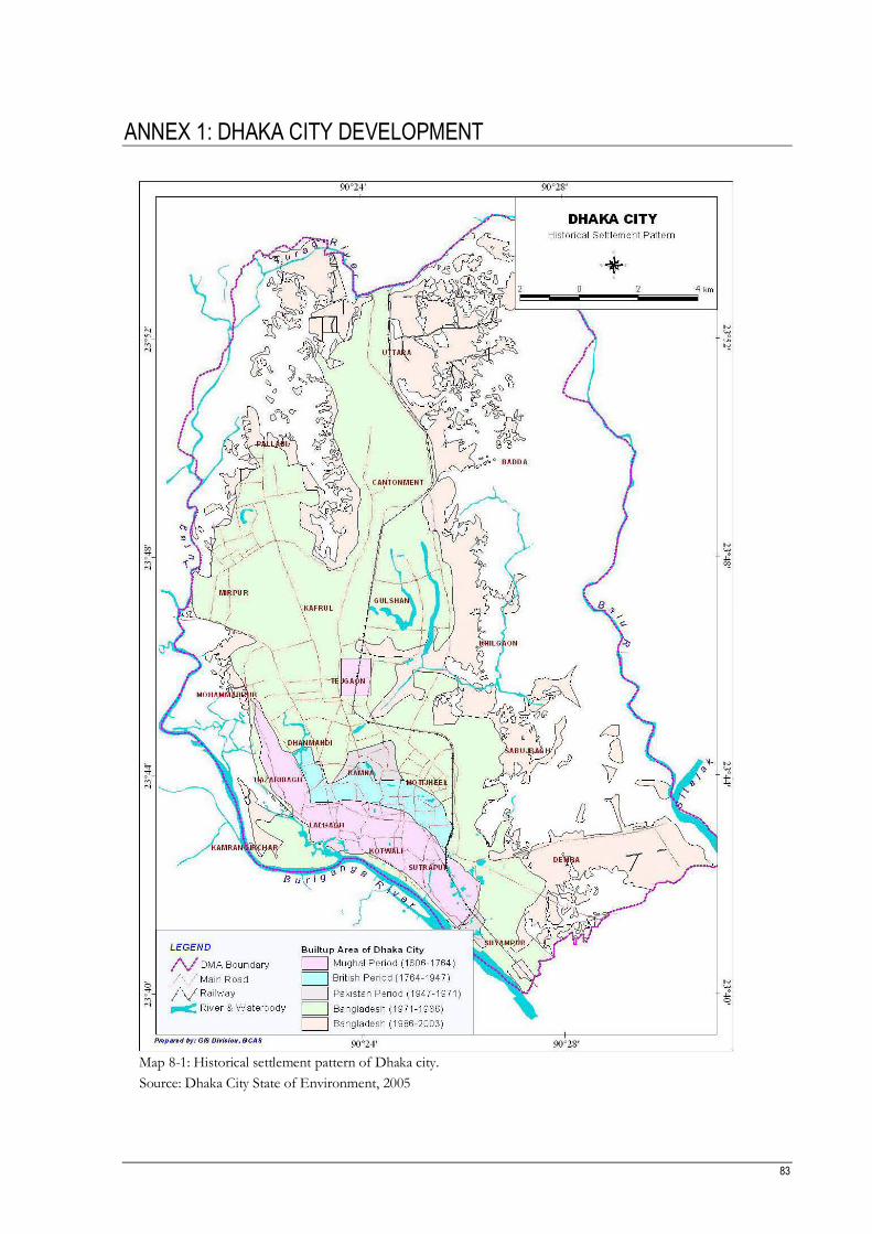
83
ANNEX 1: DHAKA CITY DEVELOPMENT
Map 8-1: Historical settlement pattern of Dhaka city.
Source: Dhaka City State of Environment, 2005


85
ANNEX 2: DHAKA CITY POPULATION GROWTH TRENDS
Table 8-1: Increasing trend of total population, area and density of Dhaka Mega City
Year Area (Km2)
Population % increase of population
over the preceding years Density (per Km
2)
1951 85.45 411,279 - 4813.09 1961 124.45 718,766 74.76 5775.54 1974 335.79 2,068,353 187.76 6159.66 1981 509.62 3,440,147 66.32 6750.41 1991 1352.82 6,844,131 98.95 5059.16 2001 1352.82 10,712,206 56.51 7918.43
Source: BBS, 1991 & 2001
Table 8-2: Increasing trend of population of DCC based on Thana
No Thana Area Km2
Year
1981 1991 2001
1 Gulshan 10.29 215329 281000 190720 2 Cantonment 14.36 116166 191000 147960 3 Lalbag 4.08 294659 402000 335040 4 Mirpur 14.22 347416 338000 577440 5 Mohammadpur 12.14 219406 316000 456300 6 Dhanmondi 6.23 142762 202000 263560 7 Tejgaon 8.89 186118 221000 301680 8 Motijheel 4.95 343821 224000 270840 9 Ramna 7.71 119299 195000 255940 10 Kotwali 1.93 188626 210000 261360 11 Sutrapur 3.99 307501 307000 352580 12 Demra (part) 31.10 326123 521000 421540 13 Sabujbagh (part) Estd. In 1988 6.74 355000 299820 14 Uttara (part) Estd. In 1988 58.85 146,000 351140 15 Hajaribagh Estd. In 1998 5.89 135060
16 Kamrangirchar Estd. In 1998 3.68 143560 17 Pallabi Estd. In 1993 17.96 440180 18 Kafrul Estd. In 1998 8.85 295880 19 Badda (part) Estd. In 1998 49.85 359380
20 Khilgaon Estd. In 1998 20.26 341800 21 Shaympur (part) Estd. In 1998 10.94 376340 22 Airport Estd. In
Source: BBS, 1983; 1991 & 2001

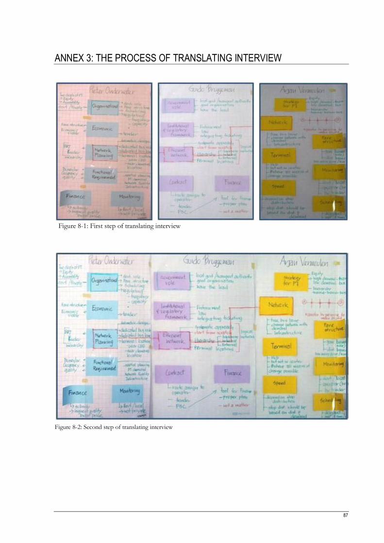
87
ANNEX 3: THE PROCESS OF TRANSLATING INTERVIEW
Figure 8-1: First step of translating interview
Figure 8-2: Second step of translating interview

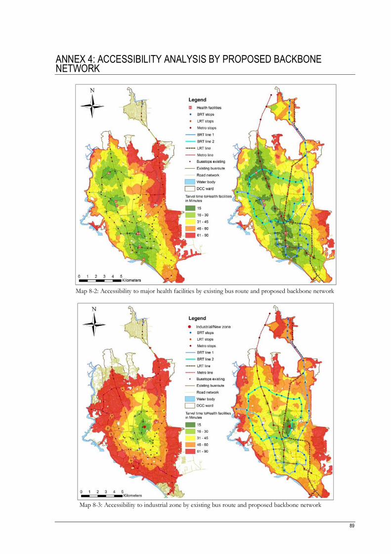
89
ANNEX 4: ACCESSIBILITY ANALYSIS BY PROPOSED BACKBONE NETWORK
Map 8-2: Accessibility to major health facilities by existing bus route and proposed backbone network
Map 8-3: Accessibility to industrial zone by existing bus route and proposed backbone network


![RATIONALIZING PUBLIC TRANSPORT: A EURO-ASIAN ...essay.utwente.nl/84978/1/niger.pdfTRANSPORT: A EURO-ASIAN PERSPECTIVE MAHER NIGER Enschede, the Netherlands, [June, 2011] DISCLAIMER](https://static.fdocuments.in/doc/165x107/60c5151050ae71661741bcaa/rationalizing-public-transport-a-euro-asian-essay-transport-a-euro-asian-perspective.jpg)