r&9 KANNUR ,9
103
r&9 KANNUR ,9" UNIYERSITY (Abstract) fuISc Geography Progruilrnrc - uncler Credit Based Sernester Systern in Affitiated Cotleges - Revised Sclrente, Syllabus & Model Questiott Papers - lmplernented rvith effect frorn 2014 admission - Orders Issued. ACADEMIC BRANCH No. Acatl/C2 I 12149 12014 Dated, Civil Station P.0,30- 09-2014 Read: l.U.O No. Acad/C 1/1 146012013 dated l2-03-20t4 2. Minr-rtes of the meetirrg of the Board of Studies in Ceograpliy (Cd) held on 26-09-2013 3. Vlinutes of the meeting of the Faculty of Science held 25.03.2014 4. Lelter dated 18.09.20 [4 frorn the Chairman, BOS in Geography (Cd) ORDBR t. The Revised Regulations for PG Programme under Credit Based Semester Systern (CBSS) were implemented in this Universiry rvith effect from 2014 admission as per paper reacl (1) above. 2. As per paper read (2) above the Board of Studies in Geography (Cd) finalized the Scheme, Syllabus & model Question Papers of MSc Geography programme to-be iniplemented r.vith etTect frorn 2014 admission. l ; 3. As per read (3) above the Faculty of Science held on 25-03-2014 approvecl Scheme, sy[labus & model question papers of MSc Geography programme to be implemented r,vith effect frorn 2014 admission. i 4. The Chairman, Board oflstudies in Geography (Cd) vide paper read (4) above has submittecl the t'inalized copy of Scheme, syllabus & Model qr.restion papers of MSc Ceography programme for implernentatior-r with eft-ect from 2014 admission. 5. The Vice Chancellor, afier examining the matter in detai[, and in exercise of the porvers of the Acadernic Council as per section I l(l) of Kannur University Act 1996 and all other enabli,g provisions read together with, has accorded ianction to implement the revised scheme, sytlabus& rnodel question papers of MSc ceography Programme with effect irom 2014 admission. I 6. Orders, are therefore issued implernenting the revised scheme, sytlabus & model cluestion papers of VISc Geography programme under Credit Based Semester System (C-BSS) i1 affiliated colleges witli ef,fect from 2014 admission subject to report to Academic council i 7. [mplemented revised Scheme, Syllabus & Model Question Papers are appended. I sd/ i DEPUTY RBGISTRAR (ACADENIIC) FOR REGISTRAR t, To: l 1. The Principals of Affiliated Colleges offering M.Sc Geography Programmes 2. The Examination Branch (through PA to CE) Contd. ..^......2
Transcript of r&9 KANNUR ,9
r&9
KANNUR ,9" UNIYERSITY(Abstract)
fuISc Geography Progruilrnrc - uncler Credit Based Sernester Systern in Affitiated Cotleges - RevisedSclrente, Syllabus & Model Questiott Papers - lmplernented rvith effect frorn 2014 admission - OrdersIssued.
ACADEMIC BRANCHNo. Acatl/C2 I 12149 12014 Dated, Civil Station P.0,30- 09-2014
Read: l.U.O No. Acad/C 1/1 146012013 dated l2-03-20t42. Minr-rtes of the meetirrg of the Board of Studies in Ceograpliy (Cd) held
on 26-09-20133. Vlinutes of the meeting of the Faculty of Science held 25.03.20144. Lelter dated 18.09.20 [4 frorn the Chairman, BOS in Geography (Cd)
ORDBR
t. The Revised Regulations for PG Programme under Credit Based Semester Systern (CBSS)were implemented in this Universiry rvith effect from 2014 admission as per paper reacl (1) above.
2. As per paper read (2) above the Board of Studies in Geography (Cd) finalized the Scheme,Syllabus & model Question Papers of MSc Geography programme to-be iniplemented r.vith etTect frorn2014 admission.
l;
3. As per read (3) above the Faculty of Science held on 25-03-2014 approvecl Scheme,sy[labus & model question papers of MSc Geography programme to be implemented r,vith effect frorn2014 admission.
i
4. The Chairman, Board oflstudies in Geography (Cd) vide paper read (4) above has submitteclthe t'inalized copy of Scheme, syllabus & Model qr.restion papers of MSc Ceography programme forimplernentatior-r with eft-ect from 2014 admission.
5. The Vice Chancellor, afier examining the matter in detai[, and in exercise of the porvers ofthe Acadernic Council as per section I l(l) of Kannur University Act 1996 and all other enabli,gprovisions read together with, has accorded ianction to implement the revised scheme, sytlabus& rnodelquestion papers of MSc ceography Programme with effect irom 2014 admission.
I
6. Orders, are therefore issued implernenting the revised scheme, sytlabus & model cluestionpapers of VISc Geography programme under Credit Based Semester System (C-BSS) i1 affiliated collegeswitli ef,fect from 2014 admission subject to report to Academic council
i
7. [mplemented revised Scheme, Syllabus & Model Question Papers are appended.
I sd/
i DEPUTY RBGISTRAR (ACADENIIC)FOR REGISTRAR
t,
To:
l
1. The Principals of Affiliated Colleges offering M.Sc Geography Programmes2. The Examination Branch (through PA to CE)
Contd. ..^......2

j,1
Forwarded/By Order
Section Officer
on to www.ksnnur university.uc.in
Copy To:1. The Chairman, BOS GeographY (Cd)2. PS to VC/PA to PVC/PA {o Registrar
3. DzuAR I Academic i
4. Central Library I
S.PAtoFO i
6. SFiDF/FCI
7. Computer Programmer I
(For Uploading in the Web Site)
l
I
F Fr" more detaits log
I
Iwll
I
i

KANNUR UNIVERSITY
PROGRAMME STRUCTURE FOR MSc GEOGRAPHY UNDER CREDIT BASED SEMESTER SYSTEM (CBSS)
Sem Course Code Course Title Instruction
al Hours
weekly
hrs Credit
sem
credit
Exam
Hours
Marks Total
marks Sem
total Internal External
1
GRY1 C01 Concepts and Trends in Geography 5
25
4
16
3 15 60 75
300
GRY1 C02 Geomorphology 5 4 3 15 60 75
GRY1 C03 Climatology 5 4 3 15 60 75
GRY1 E01 Oceanography
5 4 3 15 60 75 GRY1 E02 Political geography
GRY1 E03 Bio Geography
*Practical @ Geomorphic and Climatic Data Analysis 5 * …. … … …..
2 GRY2 C04 Geography of India 5
25
4
24
3 15 60 75
450
GRY2 C05 Regional Planning and Development 5 4 3 15 60 75
GRY2 C06 Cartography 5 4 3 15 60 75
GRY2 E04 Economic Geography
5 4 3 15 60 75 GRY2 E05 Medical Geography
GRY2 E06 social Geography
GRY2 P01 Geomorphic and Climatic Data Analysis .. 4 3 15 60 75
GRY2 P02 Quantitative Techniques in Geography 5 4 3 15 60 75
3 GRY3 C07 Remote Sensing 5
25
4
16
3 15 60 75
300
GRY3 C08 Agricultural Geography 5 4 3 15 60 75
GRY3 C09 Population Geography 5 4 3 15 60 75
GRY3 E07 Geography of Kerala
5 4 3 15 60 75 GRY3 E08 Geography of Tourism
GRY3 E09 Research Methods in Geography
**Practical @ Socio Economic data analysis and Study Tour 5 **
4
GRY4 C10 Geographic Information System 5
25
4
24
3 15 60 75
450
GRY4 C11 Urban Geography 5 4 3 15 60 75
GRY4 C12 Environmental Geography 5 4 3 15 60 75
GRY4 P0 3 Socio Economic data analysis and Study Tour .. 4 3 15 60 75
GRY4 P04 Geo informatics 5 4 3 15 60 75
GRY4 (Pr) DESSERTATION 5 2 3 8 32 40
GRY4 C13 VIVA VOCE .. 2 3 7 28 35
TOTAL 100 80 80 3 300 1200 1500 1500
* - Examination at the end of Second Semester ** - Examination at the end of Fourth Semester, Study tour to any place in India for not exceeding 15 days

1
KANNUR UNIVERSITY
COURSE STRUCTURE, SYLLABUS AND
MODEL QUESTION PAPER
FOR
MSc. GEOGRAPHY
(UNDER CREDIT BASED SEMESTER SYSTEM)
2014 ADMISSION ONWARDS

2
KANNUR UNIVERSITY MSc GEOGRAPHY
SEMESTERWISE PROGRAMME STRUCTURE
SEMESTER I
Course Code Course Title Instructio
nal Hours
Cred
it
Exa
m
Hou
rs
Marks Total
marks Intern
al
Extern
al
GRY 1 C01
Concepts and Trends in
Geography 5 4 3 15 60 75
GRY1 C02 Geomorphology 5 4 3 15 60 75
GRY1 C03 Climatology 5 4 3 15 60 75
GRY1 E01 Oceanography
5 4 3 15 60 75
GRY1 E02 Political geography
GRY1 E03 Bio Geography
Practical @
Geomorphic and Climatic Data
Analysis 5 * …. … … …..
TOTAL 25 16 3 60 240 300
SEMESTER II
Course Code Course Title Instructio
nal Hours
Cred
it
Exa
m
Hou
rs
Marks Total
marks Intern
al
Extern
al
GRY2 C04 Geography of India 5 4 3 15 60 75
GRY2 C05
Regional Planning and
Development 5 4 3 15 60 75
GRY2 C06 Cartography 5 4 3 15 60 75
GRY2 E04 Economic geography
5 4 3 15 60 75
GRY2 E05 Medical geography
GRY2 E06 social geography
GRY2 P01
Geomorphic and Climatic Data
Analysis .. 4 3 15 60 75
GRY2 P02
Quantitative Techniques in
Geography 5 4 3 15 60 75
TOTAL 25 24 3 90 360 450

3
SEMESTER III
Course Code Course Title Instructio
nal Hours
Cred
it
Exa
m
Hou
rs
Marks Total
marks Intern
al
Extern
al
GRY 3 C07 Remote Sensing 5 4 3 15 60 75
GRY3 C08 Agricultural Geography 5 4 3 15 60 75
GRY3 C09 Population Geography 5 4 3 15 60 75
GRY3 E07 Geography of Kerala
5 4 3 15 60 75
GRY3 E08 Geography of Tourism
GRY3 E09 Research Methods in Geography
Practical @
Socio Economic Data Analysis
and Study Tour 5 **
TOTAL 25 16 3 60 240 300
SEMESTER IV
Curse Code Course Title Instructio
nal Hours
Cred
it
Exa
m
Hou
rs
Marks Total
marks Intern
al
Extern
al
GRY4 C10 Geographic Information System 5 4 3 15 60 75
GRY4 C11 Urban Geography 5 4 3 15 60 75
GRY4 C12 Environmental Geography 5 4 3 15 60 75
GRY4 P03
Socio Economic data analysis
and Study Tour .. 4 3 15 60 75
GRY4 P04 Geo informatics 5 4 3 15 60 75
GRY4 (Pr) DESSERTATION 5 2 3 8 32 40
GRY C13 VIVA VOCE .. 2 3 7 28 35
TOTAL 25 24 3 90 360 450

4
KANNUR UNIVERSITY MSc GEOGRAPHY
SEMESTERWISE CREDIT DISTRIBUTION
TOTAL CREDITS 40
SEMESTER I
SEM Course Title Instructional
Hours Credit TOTAL
SEM I
CORE 15 4+4+4 12
ELECTIVE COURSE 5 4 4
PRACTICALS 5 ….. ….
TOTAL 25 16 16
SEMESTER II
SEM Course Title Instructional
Hours Credit TOTAL
II
CORE 15 4+4+4 12
ELECTIVE COURSE 5 4 4
PRACTICALS 5 4+4 8
TOTAL 25 24 24
SEMESTER III
SEM Course Title Instructional
Hours Credit TOTAL
III
CORE 15 4+4+4 12
ELECTIVE COURSE 5 4 4
PRACTICAL 5 ….. ….
TOTAL 25 16 16
SEMESTER IV
SEM Course Title Instructional
Hours Credit TOTAL
IV
CORE 15 4+4+4 12
ELECTIVE COURSE ….. …. ….
PRACTICAL 5 4+4 8
DESSERTATION 5 2 2
VIVA VOCE .. 2 2
TOTAL 25 24 24
5
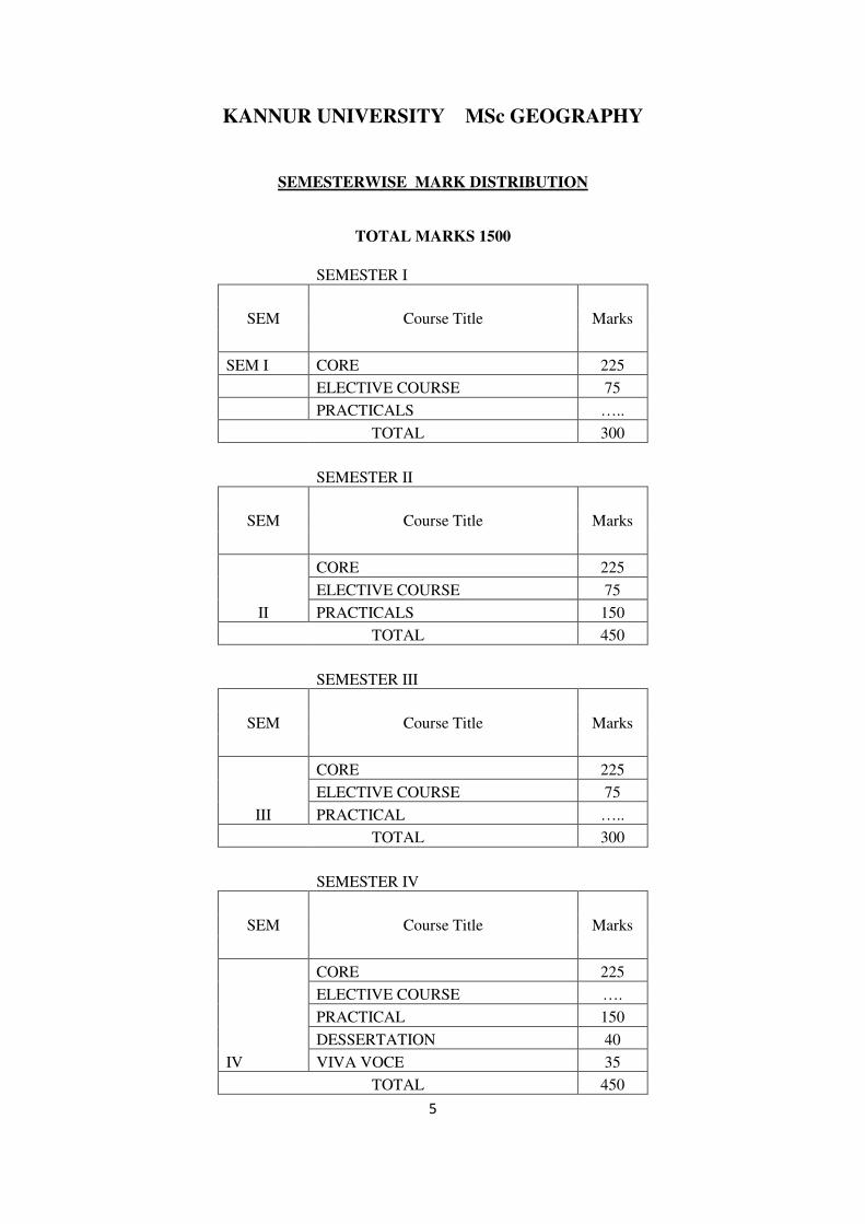
KANNUR UNIVERSITY MSc GEOGRAPHY
SEMESTERWISE MARK DISTRIBUTION
TOTAL MARKS 1500
SEMESTER I
SEM Course Title Marks
SEM I CORE 225
ELECTIVE COURSE 75
PRACTICALS …..
TOTAL 300
SEMESTER II
SEM Course Title Marks
II
CORE 225
ELECTIVE COURSE 75
PRACTICALS 150
TOTAL 450
SEMESTER III
SEM Course Title Marks
III
CORE 225
ELECTIVE COURSE 75
PRACTICAL …..
TOTAL 300
SEMESTER IV
SEM Course Title Marks
IV
CORE 225
ELECTIVE COURSE ….
PRACTICAL 150
DESSERTATION 40
VIVA VOCE 35
TOTAL 450

6
KANNUR UNIVERSITY MSc GEOGRAPHY
DETAILS OF ELECTIVE COURSES OFFERED IN DIFFERENT SEMESTERS
SE
M
Course Code Course Title
Instructi
onal
Hours
Credit
Marks Total
marks Int Ext
I
GRY1 E01 Oceanography
5 4 15 60 75 GRY1 E02 Political geography
GRY1 E03 Bio Geography
II
GRY2 E04 Economic geography
5 4 15 60 75 GRY2 E05 Medical geography
GRY2 E06 social geography
III
GRY3 E07 Geography of Kerala
5 4 15 60 75 GRY3 E08 Geography of Tourism
GRY3 E09
Research Methods in
Geography
IV .. …. …. ….. …. …. ….
TOTAL 15 12 45 180
225
Dr. P.K. VIJAYAN
Chairman
Board of Studies in Geography

7
KANNUR UNIVERSITY MSc. GEOGRAPHY
(CBSS 2014 Adm onwards)
GRY1 C01 - CONCEPTS AND TRENDS IN GEOGRAPHY
Marks 75 credit 4 5 hrs/week
UNIT I - The Field of Geography – Meaning and Scope – Fundamental Concepts –
Anamalous status of Geography as a Discipline –Nature of Geography-Geography and the
rise of the scientific revolution; Geography as a Science, its relationship with natural and
social sciences; Branches of Geography, Approaches to study geography; Development of
Geographical Thought - Classical period – Greeks, Romans, Ancient Indians, Chinese;
Medieval Period – Arabs
UNIT II - Modern Schools of Geographical Thought - German, British, French,
American, Soviet - Development of Professional Geography in France, Great Britain -
Foundations of Scientific Geography – Founders of Modern Geographical thought –
Alexander Von Humboldt, Carl Ritter, Impact of Darwinism, Ratzel, Richthofen, Alfred
Hettner, Vidal de la Blache, Jean Brunhes, Mackinder, WM Davis. EC Semple, E Hintington
UNIT III – Four traditions in Geography - Dualism and Dichotomies in Geography –
Philosophy of Determinism, Possibilism and Neo-determinism – Conceptual nature in
Geography - Positivism, Pragmatism, Functionalism, Idealism, Existentialism, Realism,
Marxism, Radicalism, Behaviouralism, Humanism; Paradigms in Geography
UNIT IV – Recent trends in Geography - Quantitative revolution, Laws, Theories and
Models in Geography, Spatial Analysis, Locational Analysis, Systems Approach and
Analysis; Inductive, deductive approaches, reasoning, Multidisciplinary approach, Welfare
Geography, Human Ecology, Sustainable development, Geography of Gender, Time and
Space Geography, Postmodernism and geography; ; Geomatics – Remote Sensing, GIS,
GPS –Date explosion -Internet resources.
References
Husain M (2007) Evolution of Geographical Thought, Rawat Publications

8
Rana L (2008) Geographical Thought: A systematic record of Evolution, Concept
Publication,
Chorley R J and Hagget P (1969) Integrated Models in Geography, Metheun, Londo
Dickinson (1969) The Maker’s of Modern Geography, Routledge and Kagen Paul,
London
Harvey, D (1989) The condition of Post Modernity: An Enquiry into the Origins of
Culutral Change, Blackwell, Oxford
Majid Husain (2009) Models in Geography, Rawat Publications,
Adhikari S (1992) Geographical Thought, Chiatanya Publishing House, Allahabad
Aeils Holt Jensen (2009) Geography, History and Concepts: A student’s guide, Sage
Dikshit, R.D (1994) Art and Science of Geogaphy, Prentice Hall of India, New Delhi
George Henderson ed. (2009) Geographic Thought, A Praxis Perspective, Routledge
Hartshorne R (1939) The Nature of Geography, Chicago
Minshull R (1970) The changing nature of Geography, Hutchinson University, London
Richard Peet (2004) Modern Geographical Thought, Blackwell Publishers
Alison Blunt (2002) Post Colinial Geogaphies, Cintinuum, New York
Dikshit R D (2006) Geogaphical Thought – A contextual Hisotry of Ideas, Prentice Hall
of India
9
MODEL QUESTION PAPER
First Semester M Sc Degree Examination
GEOGRAPHY
GRY1 C01 CONCEPTS AND TRENDS IN GEOGRAPHY
Time 3 hrs Marks 60
I Answer any six of the following; each question carries 6 marks (1+2+3)
1. i) Explain Geocratic Geography.
ii) Why Geography is considered as a anomalous discipline?
iii) Discuss the Greek contribution to Physical Geography.
2. i) What is ‘Ontography’ according to WM Davis?
ii) What do you understand by Vidal’s concept of the ‘Principles of Terrestrial unity”?
iii) Discuss the impact of Darwinism on Geographical thinking,
3. i) Define Neo-determinism
ii) How do Spatial tradition differ from Area Studies tradition in Geography?
iii) Discuss the concept and principles of “Functionalism” as a geographical thought.
4. i) What do you mean by ‘Entropy’ of a system?
ii) Discuss the concept and utility of “Time-Space” Geography
iii) Explain the modern concept of Sustainable Development
5. i) What is compage geography?
ii) Discuss the contributions made by Eratosthenees to Greek
geographical thought
iii) Discuss the place of Geography in the classification of Sciences
6. i) What is Ratzel’s concept of cultural landscape?
ii) Discuss Penck’s contribution as a formulator of geomorphology
iii) Explain the contribution of French scholars in the development of Human Geography
7. i) What does Spate mean by ‘Probabilism”?
ii) Explain Radicalist views on “Women and Environment”.
iii) Justify ‘Realism’ as a viable alternative explanation to Idealism.
8. i) What do you mean by location analysis?
ii) What are the merits and demerits of Quantitative techniques?
iii) Give an account on the data explosion in Geography.
(6 x 6 =36)

10
II. Answer any one of the following in 100 words, each question carries 3
marks
9. a) Discuss the main factors responsible for the growth and
development of geographical knowledge in the Arab world
OR
b) Why Strabo is identified as father of regional geography
10. a) Discuss the nature of exploratory geography of United States of
America,
OR
b) Discuss in brief the contribution of British geographers to economic,
agricultural and historical geography
11. a) Give an account on the dualism and dichotomy of physical geography
versus human geography
OR
b) Explain the concept of Paradigm shift and discuss on the
Paradigm in Geography
12. a) Explain the significance of Geomatics in geographical studies
OR
b) Define models and explain the uses of models in Geography
( 4 x 3 =12)
III. Answer any one of the following in 400 words, each carries 6 marks
13 a) What are the approaches to study geography? Discuss the concept
and nature of Regional and systematic approaches to study geography
OR
b) Discuss the contribution made by Alexander von Humboldt and Carl
Ritter to modern geographical thought
14. a) Discuss briefly the various themes in ‘Humanistic geography”
OR
b) Explain the conceptual aspects of Systems Approach and Systems
Analysis.
(2 x 6 =12)

11
KANNUR UNIVERSITY MSc- GEOGRAPHY
(CBSS 2014 Adm onwards)
GRY1 C02 - GEOMORPHOLOGY
Marks 75 credit 4 5 hrs/week
Unit I: Nature and scope of geomorphology- Evolution of geomorphic thought-recent trends
in geomorphology - Geological time scale- Fundamental concepts.
Unit II: Geomorphic processes- Endogenic processes- volcanism-continental drift- plate
tectonics- mountain building theories- exogenic processes- factors of weathering and
mass wasting- gradational land forms associated with respective agents.
Unit III: Land form evolution- cycle of erosion- views of W.M Davis- W. Penk- L.C. King-
land form evolution in different environments - Slopes- slope elements- slope
evolution- theories of slope evolution- down wearing, parallel retreat and slope
replacement models.
Unit IV: Climatic geomorphology – Diagnostic land forms- Morphogenetic regions-
Anthropogenic geomorphology- Human intervention on geomorphic processes-
Applied geomorphology: Meaning and concept- application in Hydrology-
engineering projects.
References
Thornbury, W. D. 1969, Principle of Geomorphology, John Wiley & Sons, New
York,.
Singh, Savinder, 1998. Geomorphology, Prayag Publication, Allahabad, 1998.
12
Embleton, C. Thormne. J. (eds) 1979. Process in Geomorphology. Edward Arnold,
London,
Bloom AL. 2002. Geomorphology : A systematic Analysis of late Canozic landforms.
Prentice – Hall Private Limited, New Delhi
Sparks B. W.,1960. Geomorphology, Longman, London.
Sharma, H.S. and Kale VS. 2009. Geomorphology in India, Prayag Pustak Bhawan,
Allahabad.
Fourbridge, R. W. (Ed) 1968 Encyclopedia of Geomorphology, John Wiley & Sons,
New York,
Sharma, V.K. 2010. Introduction to process Geomorphology. Tayler and Francs’S,
London
13
MODEL QUESTION PAPER
KANNUR UNIVERSITY
First Semester M Sc Degree Examination
GEOGRAPHY
Course: GRY1C02 GEOMORPHOLOGY
Time 3 hrs marks 60
I Answer any six of the following; each question carries 6 marks (1+2+3)
1. i) Define geomorphology
ii) What are the contributions of ancient Greeks in the development of geomorphological
thought
iii) Discuss the recent trends in geomorphology with special reference to system approach
2. i) State Uniformitarianisam concept
ii) What do you mean by cyclic nature of earth history
iii) Critically examine the views of Hotton on geomorphic processes
3. i) What are plates?
ii) What are the salient features of converging plate boundaries
iii) Discuss the significance of plate tectonic theory in geomorphology
4. i What is exfoliation?
ii) Write a short note on various forms of physical weathering
iii) Discuss the role of climate in weathering processes
5. i) Define cycle of erosion
ii) What are the assumptions of Davis regarding cycle of erosion
iii) Discuss the limitations of Davis theory of land form evolution
6. i) Name the basic slope elements
ii) What are the factors controlling slope evolution
iii) Examine the advantages of Penk’s model of slope evolution.
7. i) What do you mean by morphogenetic landforms?
ii) Discuss the recent trends in climatic geomorphology?
iii) What are diagnostic land forms? What is their significance in geomorphological
studies?
8. i) Define applied geomorphology?
ii) Explain its significance.

14
iii) Discuss the scope of geomorphology in hydrological studies.
(6X6=36)
II Answer any one of the following in 100 words, each question carries 3 marks
9. a) what are the applications of geo-informatics in geomorphology-
OR
b) Complexity of geomorphic evolution is more common than simplicity”- Justify
10. a) discuss different types of volcanoes with examples-
OR
b) What are the factors contributing the occurrence of land slides
11. a) Discuss the concept of pediplanation-
OR
b) What do you mean by Parallel retreat of slopes
12. a) Discuss the human intervention on riverine processes –
OR
b) Explain the application of geomorphology in Dam construction
(4X3=12)
III answer any one of the following in 400 words, each carries 6 marks
13 a) discuss the nature and scope of geomorphology –
OR
b) Critically examine the geo-syncline theory of mountain building
14. a) Compare and contrast the views of Davis and Penk on land form evolution
OR
b) Each climatic type produce its own characteristic assemblage of land forms-
Elucidate
(2X6=12)
15
KANNUR UNIVERSITY MSc- GEOGRAPHY
(CBSS 2014 Adm onwards)
GRY1 C03 - CLIMATOLOGY
Marks 75 credit 4 5 hrs/week
Unit I scope and content of Climatology-an integral part of geography; relationship with
meteorology- Atmosphere- structure, interaction with solar and terrestrial radiation, Climatic
elements-mutual relationships; insolation and temperature, temperature and pressure, pressure
and winds; winds as element and control of climate.
Unit II Humidity-measurement; relative humidity- significance to weather; Atmospheric
stability, instability, conditional instability -adiabatic changes; clouds- types, characteristics;
Planetary wind systems-seasonal shifting and its climatic significance; Seasonal winds-
Monsoon-theories of origin; Indian monsoon, Asiatic monsoon.
Unit III Atmospheric disturbances-cyclones; tropical, temperate; tropical storms; hurricane,
typhoon; thunderstorms-anticyclones- upper air circulation- long waves, jet streams-air mass-
source region, classification-fronts; frontogenesis-warm, cold, occluded fronts; frontolysis.
Unit IV Climatic classification- genetic and empirical schemes; classifications by Koeppen,
Threwartha, and Thornthwaite- climatic change-past and present; evidences of past climate
change; causes for present climate change-El nino, La Nina, Enso- Human intervention on
climate; Global warming- causes, consequences- Applied climatology- meaning and
significance.
References:
Critchfield, J.H., 1993. General Climatology, Prentice Hall, India, New Delhi,
Thompson, R.D. and Perry, A (ed.), 1997. Applied Climatology, Principles and Practice,
Routledge, London.
Robinson, P.J. and Henderson S., 1999. Contemporary Climatology, Henlow, Lal, D.S.:
Climatology, Chaitanya Publications, Allahabad,

16
Trewartha Glenn D, 1968. An Introduction to Climate, McGraw- Hill, Kogakusha Ltd,
Tokyo,
Lydolph, P.E., 1985. The Climate of the Earth, Rowman,
Das, P.K., 1987. Monsoon, National Book Trust, New Delhi,
Fein, J.S. and Stephens, P.N., 1987. Monsoon. Wiley Inter science,
Barry R G & Chorley P J, 1998. Atmosphere, Weather and Climate, Routledge, London
and New York,
Peterson, S. 1969, Introduction to Meteorology, Mc Graw Hill Publication, London,

17
MODEL QUESTION PAPER
KANNUR UNIVERSITY
First Semester M Sc Degree Examination
GEOGRAPHY
Course : GRY1 C03 CLIMATOLOGY
Time 3 hrs marks 60
I Answer any six of the following; each question carries 6 marks (1+2+3)
1. i) Define Insolation
ii) What are the factors controlling insolation
iii) Discuss the role of atmospheric constituents on the insolation
2. i) What do you mean by vertical distribution of temperature?
ii) What do you mean by inversion of temperature?
iii) Examine the geographical conditions leading to inversion of temperature?
3. i) What are fronts?
ii) What are the factors controlling the formation of fronts
iii) Discuss the stages in frontogenisis
4. i) What is atmospheric instability?
ii) What do you mean by conditional instability?
iii) Discuss the role of adiabatic changes on atmospheric processes
5. i) Define monsoon
ii) Discuss the factors controlling Monsoon winds
iii) Critically examine any two theories of origin of Monsoons
6. i) What do you mean by front
ii) What are the factors controlling frontogenesis
iii) Discuss the life cycle of a cyclone with the help of a diagram
7. i) What do you mean by Elnino?
ii) Discuss the factors leading to the development of Elnino and LaNina?
iii) Analyse the consequences of Elnino on global climate
8. i) Define applied climatology?
ii) Explain its significance.
iii) Discuss the scope of climatology in geomorphological studies.
(6X6=36)

18
II Answer any one of the following in 100 words, each question carries 3 marks
9. a) What are the elements of climate-
OR
b) Discuss the interrelationship between climatology and meteorology
10. a) Discuss the recent trends in climatology-
OR
b) What are the factors contributing the occurrence of thunderstorms
11. a) Discuss the concept of Global warming-
OR
b) What are the climatic conditions associated with anti-cyclones?
12. a) Discuss the impact of human intervention on atmospheric processes
OR
b) Explain the salient features of Trewartha’s climatic classifications
(4X3=12)
III answer any one of the following in 400 words, each carries 6 marks
13 a) Discuss the nature and scope of climatology
OR
b) Discuss the role of upper air circulations on global climate
14. a) Explain the climatic change and its implicationsn
OR
b) Critically examine the Koeppen’s Classification of Climate
(2X6=12)

19
KANNUR UNIVERSITY MSc- GEOGRAPHY
(CBSS 2014 Adm onwards)
GRY1 E01 - OCEANOGRAPHY
Marks 75 credit 4 5 hrs/week
Unit I: Nature and scope of oceanography- History of oceanography- Distribution of
land and water- Features in continental margin and deep ocean basins - Plate Tectonics
and marine sediments.
Unit II: Physical and Chemical properties of ocean water- inter relationships-
atmospheric circulation and oceanic circulation patterns- thermocline.
Unit III: Marine ecology and biological productivity- meaning, factors- regional and
global pattern of productivity- trophic levels and food chains- energy flow in marine
ecosystem.
Unit IV: Marine biomes and Sea organisms; meaning, characteristics, types-
classification of marine organisms; phytoplankton’s, zooplanktons- food and marine
resources of the sea- EEZ.
References
Sharma,R.C. and Vatal,M (1997) Oceanography for Geographers, Chaitanya Publishing,
Allahabad.
Lal. D.S. (2006) Oceanography, Sharda Pustak Bhavan, Allahabad.
Savindra Singh (2008), Oceanography, Prayag Pustak Bhavan, Allahabad.
20
Sharma, R.C. (1985), The Oceans, Rajesh Publications, New Delhi.
Ummerkutty, A.N.P. (1985), Science of the Oceans and Human Life, NBT, New Delhi.
Davis Richard, C.A (1986), “Oceanography- An Introduction to Marine Environment”,
Wm.C.Brown lowa.
Duxbary, C.A and Duxbury (1996), An Introduction to World Oceans, C. Brown lowa,
2nd
ed.
Garrison, T (2001), Oceanography - An Introduction to Marine Science, Books/Cole,
Pacific Grove, USA.

21
MODEL QUESTION PAPER
First Semester M Sc Degree Examination
GEOGRAPHY
GRY1 E01 – OCEANOGRAPHY
I. Answer any six of the following; each question carries 6 marks (1+2+3)
1. i) Define oceanography
ii) Give an account of the historical development of oceanography in the world.
iii) Discuss the scientific base of the origin of oceans.
2. i) Distributional characteristics of continents and oceans.
ii) continental drift theory of Wagener.
iii) continental drift theory of Taylor.
3. i) What is relief features of first order.
ii) Write a short note on convergent plate boundaries.
iii) Bring out the salient features of divergent plate boundaries.
4. i) Name the major components of sea water.
ii) Examine the sources of oceanic salinity
iii) What are the factors controlling oceanic salinity.
5. i) Mention the major features of atmosphere-ocean system.
ii) Discuss the transport of heat from equator to poles.
iii) Give an account of heating and cooling of ocean surface and atmosphere.
6. i) Define monsoon.
ii) What are the facts related to origin and mechanism of monsoon.
iii)State the concepts of the origin of monsoon.
7. i) What do you mean by water masses.
ii) Explain the sources of water masses.
iii) Discuss the thermohaline circulation.

22
8. i) Bring out the different aspects in marine ecology.
ii) Distinguish between land habitat and marine habitat.
iii) Discuss the factors influence the marine ecology. (6x6=36)
II. Answer any one of the following in 100 words, each question carries 3 marks
9. a) Give an account of the adaptation of phytoplankton’s to marine environment
OR
b) Adaptation of nektons to marine environment.
10. a) Discuss the biological productivity in marine environment
OR
b) The complexity of food chain and food web of the marine biome.
11. a) Mention the acceptance of EEZ in the world
OR
b) Exclusive economic zones is a common source of conflicts between states over
marine waters. Eluciadate.
12. a) Significance of marine resources in the oceans.
OR
b) Elaborate the law of sea treaty. (4x3=12)
III. Answer any one of the following in 400 words, each carries 6 marks
13. a) Discuss the nature and scope of oceanography
OR
b) Bring out the salient features of marine biomes in the world.
14. a) Examine the physical properties of sea water in detail.
OR
b) Explain the major characteristics of distribution of land and water. (2x6=12)

23
KANNUR UNIVERSITY MSc- GEOGRAPHY
(CBSS 2014 Adm onwards)
GRY1 E02 – POLITICAL GEOGRAPHY
Marks 75 credit 4 5 hrs/week
Unit I
Definition, Nature, Scope and Significance of Political Geography- Emergence of Political
Geography- Approaches to the study of political Geography- Functional, Landscape and
Unified Field approaches – Recent trends in Political Geography- Concept of Geopolitics-
Political Ecology- Human territory, maps and the divisions of space.
Unit II
Concepts of state- definitions and components – State formation and Classification-
Geographical factors of state- Physical, Spatial, Human and Economic factors- Concepts of
national boundary and frontier- Concepts of Nation and Nation state – Core area and Capital
cities- Nationalism.
Unit III
Global Strategic Models- Mahan’s Sea power model- Mackinder’s Geographical pivot and
Heartland model- Spykman’s Rimland model and Critical assessments of the strategic
models- Colonization, Global Organizations and Regional Associations- World
organizations- UNO, GATT, WTO- Regional associations- BRICS, SAARC, ASEAN and
EU
Unit IV
Federal System in Political Geography- Concepts of Federalism- types of federal states,
Concepts of symmetry and asymmetry model of federalism, Geographical basis of Indian
Federation, Nature of Indian federation- Partition of India and its Socio-economic and
political implications- Future of Indian federation- State partitions.

24
References
Athikari S, 1997. Fundamentals of Political Geography, Rawat Publication, Jaipur,
Rajasthan
Dikshid RD, 1999. Political Geography, Tata Mc Graw Hill Publication, New Delhi.
Dwivedi RL, 1990. Fundamentals of Political Geography, Chaithanya Publishers,
Alahabad.
Mark Blacksell, 2014, Political Geography, Routledge, London
Taylor P, 1985. Political Geography, Addison Wesly, New York
Valkenburg V, 1962. Elements of political geography. Prentice Hall, London

25
MODEL QUESTION PAPER
First Semester M Sc Degree Examination
GEOGRAPHY
GRY1 E02 – POLITICAL GEOGRAPHY
Time: 3 hrs Marks: 60
I Answer any six of the following; each question carries 6 marks (1+2+3)
1. i) Define Political Geography?
ii) What is Political Ecology?
iii) Consider Political Geography as an inter-disciplinary subject?
2. i) Describe landscape?
ii) What you mean by human territory?
iii) Describe the subject matter of Political Geography?
3. i) What is a state?
ii) Bring different components of a state?
iii) Discuss the nationalism in details?
4. i) Define a frontier?
ii) Give the importance of the nation state?
iii) Bring different definitions of states?
5. i) What is a strategic model?
ii) Explain Sea power model by Mahan?
iii) Give a geographical account of sea power model?
6. i) Define colonization?
ii) Explain BRICS?
iii) Produce a short note on Rimland?
7. i) What is a federal system?
ii) Give a detailed account on federal states?
iii) Specify the symmetry and asymmetry model of federalism?
8. i) What is Radcliff line?
ii) What is Line of Control? Explain POK & COK?
iii) Present your opinion about the future of Indian federation (6 x 6 = 36)
26
II Answer any one of the following in 100 words, each question carries 3 marks
9. a) Define Scope and Significance of Political Geography
Or
b) Differentiate between Political Geography and Geopolitics?
10. a) What you mean by core area and capital cities?
Or
b) Give a detail of classification of states with examples?
11. a) What is heart land theory? Explain?
Or
b) Give an account of regional association with suitable example?
12. a) How the partition of India influenced the economy of both sides?
Or
b) Examine the geographic basis of Indian federalism?
(4 x 3 = 12)
III Answer any one of the following in 400 words, each question carries 6 marks
13. a) Bring the development of Political Geography as a discipline?
Or
b) Explain geographical factors of a state?
14. a) Elucidate any three world organizations in details?
Or
b) Briefly explain the partition of India and its political implications?
(2 x 6 = 12)

27
KANNUR UNIVERSITY MSc- GEOGRAPHY
(CBSS 2014 Adm onwards)
GRY1 E03 – BIO GEOGRAPHY
Marks 75 credit 4 5 hrs/week
Unit I: Path of Modern Biogeography: Evolution - Plate Tectonics –- palaeontology, and
climatology; Critique of the theory of evolution; physical environment and ecological setting-
. Approaches to biogeography
Unit II: Ecological foundations of Biogeography - Principles of Ecology - Limits to
distributions: local to global scales- Speciation. Concept of bio diversity- global distribution-
threats to bio diversity- endangered species.
Unit III: Geographic Distribution of species and communities - Geographical variation
within species- The Geographic Template: Visualization and Analysis of Biogeography
Patterns with special reference to India.
Unit IV: Bio geographic Processes: Dispersal and Immigration, Extinction and Changing
Earth, Conservation and Bioethics. Ecological Biogeography- Biodiversity Patterns: Hotspots
and Cold spots- Climate Change Science and Policy- Invasive Species and Climate Change
References
G. MacDonald. 2001. Biogeography: Introduction to space, time and life. Wiley.
ISBN 0471241938. pages 1-5.
Mark V. Lomolino and Lawrence Heaney (Ed). 2004. Frontiers Of Biogeography:
New Directions in the Geography of Nature. Sinauer Associates, Incorporated, ISBN
0878934790.
Darwin, C.D. 1859. On the origin of species. John Murray. Wilson, E.O. 1992. The
Diversity of Life. W.W. Norton and Co. ISBN 0-393-31047-7. pages 94-112 and 215-
228.
Lomolino, M.V., Riddle, B.R. Whittaker, R.J., and Brown, J.H. 2010. Biogeography,
4th Ed. Sinauer. Chapter 6 dispersal and immigration 167.

28
World Commission On Environment and Development. 1987. Our Common Future.
Oxford University Press. USA. ISBN-10: 019282080X
UN. 2013. Agenda 21: Earth Summit: The United Nations Programme of Action from
Rio. UN Publications. ISBN-10: 1482672774
Briggs J C. Biogeography and Plate Tectonics. Elsivier Science Publishing Company
Inc. USA.
Eugene Pleasants Odum, Gary W. Barrett. 2005. Fundamentals of Ecology. Thomson
Brooks/Cole.
A. Townsend Peterson. 2011. Ecological Niches and Geographic Distributions (MPB-
49) (Monographs in Population Biology). Princeton University Press.
J. M. Anderson, Jonathan Michael Anderson. 1981. Ecology for environmental
sciences: biosphere, ecosystems, and man. Wiley.
Janet Franklin. 2010. Mapping Species Distributions: Spatial Inference and Prediction
(Ecology, Biodiversity and Conservation). Cambridge University Press.
M. S. Mani. 1974. Ecology and biogeography in India. W.Junk. 2009 (Digital
Edition), University of California.
29
MODEL QUESTION PAPER
First Semester M Sc Degree Examination
GEOGRAPHY
GRY1 E 03 - BIO GEOGRAPHY
Time: 3 hrs Marks: 60
I Answer any six of the following; each question carries 6 marks (1+2+3)
1. i) Define Biogeography?
ii) What is Biological niche?
iii) Consider Biogeography as an inter-disciplinary subject?
2. i) Describe Ecology?
ii) What you mean territory of an organism?
iii) Describe the territorial stress?
3. i) What is a species?
ii) Bring the hierarchical classification of living organisms?
iii) Discuss the concept of national parks in details?
4. i) Define extinction?
ii) Give the importance of red data book?
iii) Bring out the concept of ecological biogeography?
5. i) What is modern Biogeography?
ii) Explain ‘Origin of Species’?
iii) Give the geographical importance of palaeontology?
6. i) Define colony?
ii) Explain isolation and adaptation?
iii) Produce a short note on biodiversity?
7. i) What you mean by a community?
ii) Give a detailed account on territorial war between species?
iii) Specify the geographical variations of species?
8. i) What is bioethics?
ii) What is a cold spot? Explain with suitable examples?
iii) Present your opinion about the future of biodiversity in Western Ghats?
(6 x 6 = 36)

30
II Answer any one of the following in 100 words, each question carries 3 marks
9. a) Define Scope and Significance of Biogeography
OR
b) Explain different approaches to the study of Biogeography?
10. a) What you mean by the ecological foundations of Biogeography?
OR
b) Give a detail account of endangered species with suitable examples?
11. a) What is the importance of foothills of Himalaya in biodiversity? Explain?
OR
b) Give an account of regional distribution of wild animals in India?
12. a) Distinguish between in-situ and ex-situ conservation? Give examples?
OR
b) Describe the major biological hotspots in India?
(4 x 3 = 12)
III Answer any one of the following in 400 words, each question carries 6 marks
13. a) Explain the theory of evolution?
OR
b) Elucidate the causes and consequences of Biodiversity degradation?
14. a) Give a detailed account on distribution of the major aquatic species on the
world?
OR
b) Briefly explain the consequences of climatic changes on biotic component of
the earth?
(2 x 6 = 12)

31
KANNUR UNIVERSITY MSc- GEOGRAPHY
(CBSS 2014 Adm onwards)
GRY1 P01 – GEOMORPHIC AND CLIMATIC DATA ANALYSIS
Marks 75 credit 4 5 hrs/week
Unit 1: Slope analysis – profiles- Calculation of average slopes, methods of preparation of
slope maps - Trend surface analysis- Hypsometric curve, area – height curve, clinographic
curve & altimetric frequency curve.
Drainage basin morphometry - Identification of watersheds – Calculation of basin area -
stream ordering and its significance – Characteristics of drainage basin – Bifurcation ratio-
Density, Structure, Basin Intensity – Drainage pattern
Unit II: Block diagrams – One point perspective & Two point perspective – Preparation of
block diagrams from contour maps – Multi section method. Block diagrams representing
erosional and depositional features produced by river, glacier, wind, under goundwater and
waves.
Surveying- Preparation of maps using plane table and drawing profiles using the Dumpy
level
Unit III: climatic data analysis- climatic maps and diagrams – Isopleths- representation of
different climatic data by Isopleths, Columnar, Linear and Circular graphs – Frequency
graphs – Trend graphs - Wind Rose diagrams – Climographs, Hythergraphs, Climatograph-
Study of Indian daily weather map of two different seasons.
Unit IV: Analysis of water balance- Concept of water balance – Calculation of water
balance using Thorthwait method – Index of Aridity – Determination of climatic types by
using Thornthwait’s method –
References
L.R Singh, (2009): Fundamentals of Practical Geography, Sharda Pustak Bhavan
A. M. Bangulia, (2006), Practical Geography, Anmol publishers Pvt Ltd

32
L.R Singh, (2009): Fundamentals of Practical Geography, Sharda Pustak Bhavan
Monkhouse FJ, Wilkinson- Maps and Diagrams, Muthen& Col Ltd, London
Siya Ram Sharma, (2008): Practical Geography, Murali Lal & Sons Pvt.Ltd
M.D Zulfequar ahmad Khan, (1998): Text book of Practical Geography, concept Pubishing
company
R.L Singh & Rana P.B. Singh,(2005): Elements of Practical geography, Kalyani Publishers
Ashish Sarkar, (2009): Practical Geography a systematic approach. Orient Blackswan Pvt Ltd
Dent BD (1990). Cartography, Thematic Map Design, Brown Publishers
Imhof E (1982). Cartographic Relief presentation, Walter de Gryter, New York
Keates J S (1989). Cartographic Design and Production, Longman Group UK Limited,
London
Robinson, H Arthur et al, (2002) Elements of Cartography, John Wiley and Sons, Inc.
Singapore

33
KANNUR UNIVERSITY MSc- GEOGRAPHY
(CBSS 2014 Adm onwards)
GRY2 C04 - GEOGRAPHY OF INDIA
Marks 75 credit 4 5 hrs/week
Unit I: Location and space relation, unity and diversity. Land: Major terrain and
stratigraphical units of India and other characteristics. Drainage system and their functional
significance of the country, the Indian monsoon, recent views – regional and seasonal
variations, regionalization of climate in India- soil regions and their characteristics,
Vegetative zones – characteristics and their conservation
Unit II: Economy: changing nature of Indian economy – an overview. Main and
characteristics and problems of Indian agriculture, spatial patterns, land use, cropping pattern,
irrigation, technological development in agriculture, Green revolution and its spatial
dimensions; regionalization of agriculture in India, food production and population growth.
Unit III: Mineral and power resources, production and problems of conservation, Resource
regions of India; Industry – industrial development and Indian economy an overview,
locational patterns of industrial activity, localizations factors and spatial pattern of major
industries in India, Iron and steel, engineering goods, textiles, chemicals, cement, sugar,
paper etc, industrial regions of India.
Unit IV: Transport and trade, development of transport network different modes and their
functional significance, internal and international trade – composition and change (both
spatial and temporal terms)

34
References
Sharma, T. C. and Continho, (1988). Economic and Commercial Geography of India,
Vikas Publishing House, New Delhi.
Khullar, D. (2000). India-A Comprehensive Geography, Kalyani publishers, New
Delhi.
Nag, P. and Roy, P. (1998). Geography of India, Concept Publications, New Delhi.
Memoria, C. B. (1984). Economic and Commercial Geography of India, Shivlal
Agarwal Publication Co. Agra.
Gopal Singh (1976). Geography of India, Atma Ram, India
Tirtha, R. (1996). Geography of India, Rawat Publications, Jaipur.
Gopal Singh (1976). Geography of India, Atma Ram, India.
India, (2014).Year Book, Ministry of Information and Broadcasting, Govt. of India

35
MODEL QUESTION PAPER
Second Semester M Sc Degree Examination
GEOGRAPHY
GRY2 C04 - GEOGRAPHY OF INDIA
Time 3 hrs Marks 60
I Answer any six of the following; each question carries 6 marks (1+2+3)
1. i) What is Redcliff line?
ii) Describe the distribution of Gondwana rocks in India
iii) Distinguish between the east peninsular rivers and Himalayan rivers
2. i) List out the major Kharif crops?
ii) Explain the FDI?
iii) Describe the types of irrigation systems in India?
3. i) Mention the distribution of iron and steel industries in India?
ii) Examine the features of sugar industries in India?
iii) Explain the major industrial regions of India?
4. i) Mention the major mountain passes in India ?
ii) Elaborate the water ways in India?
iii)Give an account of major export items of India?
5. i) What is mean by Thermal concept of origin of monsoon in India?
ii) Explain the seasons in India?
iii) Discuss the uneven distribution of rainfall I India?
6. i) Describe green revolution in India?
ii) Write a short note on food production of India?
iii) Explain the environmental problems related with green revolution in India
7. i) What are the major nuclear power plants in India ?
ii) Explain the distribution of coal in India?
iii) Give an account of textile industries in India?
8. i) Describe about India and ASEAN Agreement?
ii) Write a detailed note on India’s railway zones?
iii) Give an account on the inland water ways in India
(6 x 6 =36)

36
II. Answer any one of the following in 100 words, each question carries 3 marks
9. a) Discuss the concept unity and diversity in India
OR
b) Describe the Himalayan mountain system?
10. a) Bring out the major problems of Indian agriculture?
OR
b) Explain the major cropping pattern of India?
11. a) Discuss the minerals regions of India?
OR
b) Give an account of iron and steel industries in India?
12. a) Discuss the major constraints in railway development in north eastern India
OR
b) Examine the uneven distribution of population distribution in India?
(4 x 3 =12)
III. Answer any one of the following in 400 words, each carries 6 marks
13. a) Discuss the major soil group found in India?
OR
b) Evaluate the salient features of Indian agriculture?
14. a) Briefly explain the power resources of India?
OR
b) Examine the historical developments of major industries in India
(2 x 6 =12)

37
KANNUR UNIVERSITY MSc- GEOGRAPHY
(CBSS 2014 Adm onwards)
GRY2 C05 - REGIONAL PLANNING AND DEVELOPMENT
Marks 75 credit 4 5 hrs/week
Unit I: Concept of region and regional planning, Types of regions, Planning regions and its
characteristics, Hierarchy of regions, Delineation of regions and methods of delineation.
Types of planning, Objectives and principles of regional planning , approach to regional
planning
Unit II: Theories of regional growth: Economic base theory, convergence and divergence
growth theory, Multiplier effects, Intra and Inter regional planning, Input output analysis.
Growth pole hypothesis and regional planning Polarization effects- inadequacies of growth
pole hypothesis. Modified growth foci concept of RP Misra.
Unit III: Regional imbalance and the levels of development- causes and consequences Need
for balanced regional development, Indicators of measuring regional imbalance and extent of
regional imbalance in India. Policies and programmes to remove regional imbalance in India
Unit IV: Issues in regional planning and approach to planning; social environmental issues,
top down and bottom up approaches. District, Block and panchayath level planning in India.
Backward and tribal area development programmes, People participation in planning process,
watershed planning.
References
Misra R.P, 1969. Regional Planning, Concepts, Techniques, Policies and Case studies,
Concept Publishing Company, New Delhi
Chandana R.C, 2004. Regional Planning, Kalyani Publishers, Ludhiana
Mahesh Chand and Puri V.K, 2011. Regional Planning India, Allied Publishers PVT LTD ,
New Delhi.
Misra R,P and Achyutha R.N, 1998. Micro level Rural Planning – Principles, Methods and
Case Studies, Concept Publishing Company, New Delhi
38
Rangawala, 2005. Town Planning, Charotar Publishing House, Anand.
Sukhamoy Chakravarthy, 2010. Development Planning, The Indian Experience, Oxford
Univdrsity Press, New Delhi.
Sakundala Devi, 2006. Planning and Rural Development, Indian Perspective, Sarup and Sons,
New Delhi
39
MODEL QUESTION PAPER
Second Semester M Sc Degree Examinations December 2014
GEOGRAPHY
GRY2 C05 – REGIONAL PLANNING AND DEVELOPMENT
Time 3 hrs Marks 60
I Answer any six of the following; each question carries 6 marks (1+2+3)
1. i) What you mean by adhoc region ?
ii) Describe the types of planning?
iii) Explain the characteristics of planning region?
2. i) Explain the term regional growth?
ii) Write a short note on multiplier effect?
iii) Give an account of economic base theory?
3. i) Define growth pole?
ii) What are the concepts developed by Gunard Myrdel about the growth pole theory?
iii) Distinguish between trickling down and polarization ?
4. i) What you mean by regional imbalance ?
ii) Give an account of integrated area development programme (IRDP)?
iii) Explain the causes of regional imbalance in India?
5. i) District level planning in India?
ii) Describe the top down and bottom up approach in regional planning?
iii) Explain people participation in watershed planning?
6. i) Define Compage?
ii) Bring out the features of natural regions?
iii)What are the objectives of planning
7. i) Explain the input and output analysis ?
ii) Mention about backward and tribal area development programme?
iii) Give an account of growth pole concept according to RP Mishra?
8. i) Define integrated regional development ?
ii) What are the major policies for the removal of regional imbalance n India?
iii) Explain the significance of Panchayath level planning in India?
(6 x 6 =36)
40
II. Answer any one of the following in 100 words, each question carries 3 marks
9. a) Discuss the geographical perspective in regional planning?
OR
b) Explain various methods for regional delineation?
10. a) Give an account of intra and inter regional planning?
OR
b) Discuss the environmental and social issues related to regional planning?
11. a) Examine the need for balanced regional development?
OR
b) Explain the various indicators of measuring of regional imbalance?
12. a) Briefly explain the approaches to regional planning?
OR
b) Write a short note on five year plans in India? (4 x 3 =12)
III. Answer any one of the following in 400 words, each carries 6 marks
13. a) Discuss the types of regions in regional planning?
OR
b) Explain the causes and consequences or regional imbalances in India with suitable
examples?
14. a) Briefly explain the growth pole theory?
OR
b) Discuss the planning policies for tackling regional imbalances in India
(2 x 6 =12)

41
KANNUR UNIVERSITY MSc- GEOGRAPHY
(CBSS 2014 Adm onwards)
GRY2 C06 CARTOGRAPHY
Marks 75 credit 4 5 hrs/week
Unit I Cartography – Nature and scope – Cartographic communication process – History
of cartography; Types of maps – Map characteristics – Map functions and types - Simple
and complex thematic maps, Special purpose maps; Basic Geodesy – Map Projections -
Scale, reference and coordinate Systems: Cartographic data and processing – Sources –
image processing – digital database – cartographic data base management – statistical
processing – GIS
Unit II Map compilation – Compilation process, Compilation Worksheet - Cartographic
Abstraction – Selection and Generalization Principles – Graphic and conceptual processes
and tools; Symbolization, Symbolization problem, Feature Attributes – Portraying of land-
surface form – Relief – Digital terrain models – terrain visualization – topographic data
mapping and charting organizations.
Unit III Cartographic design – Design process – perceptual considerations – Controls of
map design – Design planning – Color Theory and Models - Pattern creation - Lettering and
Toponomy – Functions - Lettering style, size, types - Nature of typography, Lettering the
map Topography – Georeferencing, Map projections, Geometric transformations;
Geostatistics, Statistical mapping – Surveys, Cartographical data analysis, classification -
Mapping methods
Unit IV Map reproduction - Methods and techniques of Map reproduction - Role of
Remote sensing in the development of Cartography, Automation in Cartography;
Cartographic tools - Geographic Information Systems and Maps – Geospatial data – Digital
data products, Geospatial analysis and operations – GIS packages -

42
References
Robinson A. H Arthur et al. (1995): Elements of Cartography, John Wiley & Sons,
New York.
Taylor DRF (1983): Graphic Communication and Design in Contemporary
Cartography, John Wiley & Sons, New York
Menno Jan Kraak, Ferjan Ormeling (2004): Cartography Visualization of Geospatial
Data, Pearson Education
Dent BD (1990) : Cartogaphy, Thematic Map Design, Brown Publichsers
Imhof E (1982) : Cartographic Relief presentation, Walter de Gryter, New York
Monmonier M S (1982) : Computer Assisted Cartography: Principles and Prospects,
Englewoood Cliffs NJ , Prentice Hall
Robinson A. H Arthur et al (1995) : Elements of Cartography, John Wiley & Sons
Brown LA (1949): Maps and Map Makers, Batsford, London
Keates, J.S (1982): Understanding Maps, John Wiley & Sons, Newyork
Lillesand TM, Keifer RW (1994): Remote Sensing and Image Interpreter, John
Wiley & Ssons, New York
Misra R P, Ramesh A (1969): Fundamentals of Cartography, Concept Publishing
Company, New Delhi
Pearson, F (1990) : Map Projections: Theory and Applications, CRC Press
Prithvish Nag (1992): Thematic Cartography and Remote Sensing, Concept
Publishing Co. New Delhi

43
MODEL QUESTION PAPER
Second Semester M Sc Degree Examinations December 2014
GEOGRAPHY
GRY2 C06 - CARTOGRAPHY
Time 3 hrs Marks 60
I Answer any six of the following; each question carries 6 marks (1+2+3)
1. i) Define Cartography.
ii) Distinguish between Magnetic north and True North ?
iii) Explain Cartogaphy as a Science of human communication.
2. i) What is pull-ups?
ii) Distinguish between Vertical photographs and Oblique photographs
iii) Briefly explain the ideal characteristics of a map projection
3. i) What are Block diagrams
ii) Mention the methods of mapping the climatic data
iii) Explain the theory of Visual perception
4. i) Explain qualitative area symbols?
ii) Illustrate the format of a map
iii) Briefly explain the major constraints in Map design
5. i) What is isochrones map?
ii) Distinguish between simple and complex thematic maps
iii) Give a brief account on the visual variables in Symbolization
6. i) Explain UTM Grid System?
ii) What are the various forms of Electronic imaging?
iii) Explain the major co-ordinate systems used on maps
7. i) Explain Isarithmic mapping?
ii) What are the sources of digital data?
iii) Give a brief account on the controls of map design.
8. i) What are Electronic Display Screens?
ii) Explain the function of an Image Mapping Software?
iii) Give an account on the Graphic file formats in digital cartography.
(6 x 6 =36)

44
II. Answer any one of the following in 100 words, each question carries 3 marks
9. a) Explain the significance of Cartography in Geography
OR
b) Mention the methods of changing map scale
10. a) Explain the need for the standardization of symbol
OR
b) Explain the stages of map compilation
11. a) Explain the methods applied in the cartographic data analysis
OR
b) Discuss the various colour theory and models in map design
12. a) Explain the significance of Geomatics in Cartography
OR
b) Discuss the role of maps as a decision tool
( 4 x 3 =12)
III. Answer any one of the following in 400 words, each carries 6 marks
13 a) Discuss briefly the sources of cartographic data and its processing
OR
b) Explain the major principles and processes in Cartographic
abstraction
14. a) Discuss briefly the various aspects of lettering and typography in
Cartography
OR
b) Give a detailed account on the latest techniques in map reproduction (2 x 6 =12)

45
KANNUR UNIVERSITY MSc- GEOGRAPHY
(CBSS 2014 Adm onwards)
GRY2 E04 - ECONOMIC GEOGRAPHY
Marks 75 credit 4 5 hrs/week
Unit I: Economic Geography -Definition, Nature and Scope and Significance of economic
Geography. Approaches to the study of Economic Geography. Multi Disciplinary Nature –
economic geography and commercial geography, resources geography .Functional concepts
in economic geography
Unit II : Economy and Economic systems Concepts- Brief history of Economy ,operation
of the economy ,approaches ,Geographical perspectives on the economy ,Types of economic
systems .Key factors in Economic Space –state, ,types of firms ,corporations
Unit III : Economic activities –meaning and classification ,primary activities-Agriculture-
types and systems , Fishing , Hunting and Food Gathering ,Mining and livestock rearing
.Resources –meaning ,classification ,major resources –mineral resources ,energy and power
resources ,Human resources .Resources and Environment –Environmental problems –
depletion and degradation of resources.
Unit IV : Recent trends in Manufacturing, Transport and Trade-manufacturing
industries –iron and steel ,textiles industry ,engineering industry .Industrial Regions of the
world . Transport- means of Transport -Road ,Rail ,Water and Air transportation .Trade and
Development-trade agreements ,Regional and global Associations and organizations- UNO,
GATT, WTO –European union, ASEAN,BRICS,SAARC-Policies and programmes

46
References
K.K.Khanna and Dr.V k Gupta 2002 ,Economic and commercial Geography, Sultan
chand publications New Delhi.
Truman A Hartshorn and John w Alexander2002 ,Economic Geography ,Prentice Hall
India
Dr Alka Gautham 2004Advanced Economic Geography, Sharda Pustak Bhavan
Allahabad
R Jagannathan2012, Economic Geography ,Dominant Publishers New Delhi
Dr .Ahmad Husain 2006 Economic Geography,Vishvabharati Publications New Delhi
Majid Husain 1998Economic Geography ,Anmol Publications Pvt Ltd Newdelhi
William P Anderson, 2012. Economic Geography, Routledg Publishers London –
Newdelhi
M .A Bangash, 2006. Economic Geography, Anmol Publications Pvt Ltd Newdelhi
Prithwish Roy, 1992. Economic Geography – Study of Resources, New Central Book
Agency, London.
47
MODEL QUESTION PAPER
Second Semester M Sc Degree Examination
GEOGRAPHY
GRY2 E04 - ECONOMIC GEOGRAPHY
Time 3 hrs Marks 60
I Answer any six of the following; each question carries 6 marks (1+2+3)
1. i) Define economic geography?
ii) Describe spatial approaches in economic geography?
iii) Differentiate economic geography from commercial; geography?
2. i) What is mean by mixed economy?
ii) Distinguish between developing and developed countries?
ii) Describe operations of the economy in a region?
3. i) What is mean by footloose industries?
ii) Describe the significance of Suez Canal?
iii) Give an account of inland water ways in India?
4. i) Mention the key factors in economic space?
ii) Describe the types of economy?
iii) Give a short note on the significance of Konkan Railway?
5. i) Panama canal?
ii) Write a short on ASSEAN free trade agreement?
iii) Examine the railway development tin India
6. i) What is mean by quaternary activities?
ii) Explain the population density of the world?
iii) Discuss the merit and demerit of Free Trade Agreement
7. i) List out the major mineral resources of the word?
ii) Describe continental Trans Siberian Railway
iii) Explain the Rostow’s model of economic development
8. i) What is mean by commodity approach?
ii) Elucidate the nature of Economic Geography?
iii) Give an account on uneven distribution of resources?
(6 x 6 =36)

48
II. Answer any one of the following in 100 words, each question carries 3 marks
9. a) Briefly explain the functions of state as a economic space?
OR
b) Explain the scope of economic geography?
10. a) Discuss on the planned economy
OR
b) Examine the geographical perspectives on the economy?
11. a) Give a detailed account on renewable and non renewable resources?
OR
b) Describe the environmental impact of slash and burn agriculture?
12. a) Explain briefly the major textile industries of the world?
OR
b) Discuss the major ocean route of the world?
(4 x 3 =12)
III. Answer any one of the following in 400 words, each carries 6 marks
13. a) Discuss the major concepts in Economic Geography?
OR
b) Examine the historical development of economy?
14. a) Evaluate the availability of power resources in the world?
OR
b) Explain the growth and development of iron and steel industry in the world
(2 x 6 =12)
49
KANNUR UNIVERSITY MSc- GEOGRAPHY
(CBSS 2014 Adm onwards)
GRY2 E05 - MEDICAL GEOGRAPHY
Marks 75 credit 4 5 hrs/week
UNIT-I. Concepts and Traditions: Definition, nature and scope, objectives of medical
geography elements, Growth and developments of medical Geography ,methods and
techniques- Geographic information system .Medical developments in India
UNIT-II. Human-Environment Interaction: Health and environment-concept of health,
Geographical approaches of health, Natural environment and health- Inorganic and Organic,
Social environment and health : Food intake, Perception of diseases,Treatment of
diseases,Socio-economic conditions and health. Food poison Biogeomedical wastes –types
and their management ,occupations and health Environment
UNIT-III. Modernization, Population change and health: Disease classification-
Genetic, Communicable, non-communicable, Occupational, deficiency diseases, WHO
Classification of diseases. Diseases Diffusion: Meaning, factors/barriers, Phases, Types of
diffusion. Epidemiological Transition-The theory of epidemiological transition (Omran
theory) factors of transition- Demographic, Changes in risk factors, Practices of modern
medicine. Indicators. Migration and diseases
UNIT-IV. Global Inequalities in Health resources: Concept of health care, levels of health
care, social context of disease, health care accessibility and utilization, Health care system
world wide, health care services in India, health care policy in India.special and
empowerment Programmes for woman and childrens
References:
Husain Majid (1994): ‘Medical Geography’, Amol Publication Pvt.Ltd. New
Delhi
Learmonth A T A (1978): ‘Patterns of diseases and hunger’, a case study in
Medical Geography, David and Charles, Victoria
50
May J M (1970): ‘The world atlas of diseases’ National Book Trust, New Delhi
Mc. Glashan N.D (1972): ‘Medical Geography, Methuen, London
Misra R P (1970): ‘Medical Geography’ National Book Trust, New Delhi
Rais A S Learmonth A T A (1990): ‘Geographical aspects of health and diseases
in India’ Rawat Publication, Jaipur
Stamp L. D. (1964): ‘Some aspects of Medical Geography’, Oxford University
Press Oxford
M.S.Meade and R.J. Erickson (2005), Medical Geography Guilford press.
51
MODEL QUESTION PAPER
Second Semester M Sc Degree Examinations December 2014
GEOGRAPHY
GRY2 E05 - MEDICAL GEOGRAPHY
Time 3 hrs Marks 60
I Answer any six of the following; each question carries 6 marks (1+2+3)
1. i) Define medical Geography?
ii) Describe the methods in medical geography?
iii) Distinguish between traditional and modern medicine ?
2. i) What is mean by human environment ?
ii) Explain the organic and in organic conditions of human health ?
iii) Describe various junk food and its effects on health ?
3. i) What is mean by disease ecology ?
ii) Distinguish between the communicable and non communicable diseases ?
iii) Give an account on deficiency diseases?
4. i) What is mean by health transition ?
ii) Write a short notes on the need for biomedical waste management system ?
iii) Give an account of methods of water and energy conservation in the health care ?
5. i) Briefly explain the elements of medical geography ?
ii) Write a short on contributions of Hippocrates in the field of medicine ?
III) Explain the significance of GIS in health care planning ?
6. i) What are the factors responsible for waterborne diseases ?
ii) Write a short notes on demographic changes on health pattern ?
iii) Discuss the consequences of fast food behavior ?
7. i) Define genetic diseases ?
ii) Describe the factors related to diseases diffusion?
iii) Briefly explain the development of modern medical system?
8. i) Mention the diseases related to radioactive explosion ?
ii) Write a short notes on health care accessibility and utilization?
iii) Give a detailed account on empowerment programmes for woman and children in
India?
(6 x 6 =36)
52
II. Answer any one of the following in 100 words, each question carries 3 marks
9. a) Briefly explain the types of disease diffusion ?
OR
b) Explain the theory of epidemiological transition ?
10. a) Discuss the nature and scope of medical geography ?
OR
b) Explain the objectives of Medical geography ?
11. a) Examine the relationship between socio economic conditions and health status ?
OR
b) Give an account on geographical approaches of health conditions?
12. a) Explain the concept of health care delivery system ?
OR
b) Discuss the health care policies in India ?
(4 x 3 =12)
III. Answer any one of the following in 400 words, each carries 6 marks
13. a) Discuss the growth and development of modern medical Geography?
OR
b) Examine the influence of natural environment on human health?
14. a) Give a detailed account on the classification of diseases ?
OR
b) Evaluate the significance of worldwide health care system ?
(2 x 6 =12)

53
KANNUR UNIVERSITY MSc- GEOGRAPHY
(CBSS 2014 Adm onwards)
GRY2 E06 - SOCIAL GEOGRAPHY
Marks 75 credit 4 5 hrs/week
Unit I : Nature, Scope and Contents of Social Geography- Emergence of Social Geography-
Relationship of social geography with other Social Sciences - Social variations in space-
Causes and Consequences.
Unit II: Evolution of man and society- spatial distribution and characteristics of primary
races of the world- Evolution of languages and its diffusion- Influence religion and creeds in
social life- Cradle lands of major religions. Rise of civilization and urbanization- socio
economic characteristics of Mesopotamian, Nile, Indus and Hwang Ho valley civilizations -
Unit III: Indicators of Social Wellbeing- Social indicators, Economic indicators, Material
indicators and Psychological indicators- Security feeling- Personnel, Economic, Family,
Environmental and Neighbourhood – Gender issues in social wellbeing- Family planning and
women health.
Unit IV: Social area analysis- social indicators movement- Personal capital and Social
capital- Social inequalities in different level- Household, Localities, Districts, States and
National levels- Micro level Human Development Index and Quality of Life.
References
Aijazuddin Ahmad, 1999. – Social Geography, Rawat Publication, Jaipur
Hammelt, Chris (Ed.), 1975. Social Geography, A Reader, Oxford University Press, London.
Kulkarni K M, 1990. Geographical Patterns of Social Wellbeing, Concept Publishing
Company, New Delhi.
Paul Knox, 1975. Social Wellbeing, A Spatial Perspective, Oxford University Press, London.
Pacliona M (Ed.), 1987. Social Geography- Progress and Prospects
Smith David, 1973. Social Problems and the City, Oxford University Press, London.

54
MODEL QUESTION PAPER
Second Semester M Sc Degree Examination
GEOGRAPHY
GRY2 E06 - SOCIAL GEOGRAPHY
Time 3 hrs Marks 60
I Answer any six of the following; each question carries 6 marks (1+2+3)
15. i) Define areal differentiation?
ii) What is an ideal society?
iii) Explain Social Geography?
16. i) Describe Neolithic period?
ii) What you mean by race?
iii) Explain the creed of Christianity?
17. i) What is a household?
ii) Bring the concept of quality of life?
iii) Discuss the human development index?
18. i) Bring the concept of social wellbeing?
ii) What is an indicator?
iii) Define social indicators movement? Give its importance in Geography?
19. i) What is spatial organization?
ii) Define social capital?
iii) Give an idea of environmental impact on human life?
20. i) What you mean by a society?
ii) Give physical characteristics of Mangloids?
iii) Produce a short note about cradle lands of major religion?
21. i) Define social structure?
ii) What is urbanization?
iii) Give an account of Hwang Ho valley civilization?
22. i) Define a Neighborhood?
ii) What is territorial social indicator?
iii) Present a short note about economic indicators of wellbeing?
(6 x 6 = 36)
55
II Answer any one of the following in 100 words, each question carries 3 marks
23. a) Explain the relationship of social geography with sociology?
OR
b) Give the basic principle of social geography?
24. a) What is ethnicity? Give detail of Hinduism in Indian context?
OR
b) Give an account of areal and social characteristics of Negroids?
25. a) Conceptualize social inequalities?
OR
b) Give an account of social organization of Indus valley civilization?
26. a) How the security feeling influence quality of life?
OR
b) Examine the gender issues in social wellbeing?
(4 x 3 = 12)
III Answer any one of the following in 400 words, each question carries 6 marks
27. a) Bring the concept of social variations in space?
OR
b) Elucidate the diffusion of different languages on globe?
28. a) Correlate the rise of civilization and urbanization?
OR
b) Briefly explain different types of social indicators?
(2 x 6 = 12)

56
KANNUR UNIVERSITY MSc- GEOGRAPHY
(CBSS 2014 Adm onwards)
GRY2 P02 - QUANTITATIVE TECHNIQUES IN GEOGRAPHY
Marks 75 credit 4 5 hrs/week
Unit 1: Introduction to computer hardware and software – advantage and applications of
computers in Geographical studies. Introduction to Operating Systems- Database concept,
data models. DBMS.
Unit II: Working with Microsoft Word, Microsoft Excel & Microsoft Power Point –
Representation of geographical data through graphs and diagrams-Statistical Software- SPSS
Unit III: Quantitative techniques in geography- Statistical analysis- Correlation and
Regression analysis - Testing measures – testing hypothesis – tests of significance – students
t test, ‘F’ test, Chi-square test
Unit IV: Map projections. Classifications of map projections, construction of graticule for
the following projections (graphical method only) Zenithal projections – Gnomonic,
Stereographic and Orthographic (Equatorial case only); Conical projection – International
projection, Cylindrical projection –, Conventional projection – Globular, Interrupted
Mollweide’s, Interrupted Sinusoidal.
References
Michael Miller (2007), Absolute Beginner’s guide to computer Basics, Fourth
Edition, Pearson Education
Peter Norton, (2007). Introduction to computers, Sixth Edition TataMcGraw Hill

57
Alexis Leon, Mathews Leon, and Vijay Nicole 2004. Introduction to Information
Systems, imprints private Limited, Chennai,
Monkhouse FJ, Wilkinson- Maps and Diagrams, Muthen& Col Ltd, London
Siya Ram Sharma, (2008): Practical Geography, Murali Lal & Sons Pvt.Ltd
M.D Zulfequar ahmad Khan, (1998): Text book of Practical Geography,concept
Pubishing company
R.L Singh & Rana P.B. Singh,(2005): Elements of Practical geography, Kalyani
Publishers
Ashish Sarkar, (2009): Practical Geography a systematic approach. Orient Blackswan
Pvt Ltd
Robinson, H Arthur etal, (2002) Elements of Cartography, John Wiley and Sons, Inc.
Singapore
Danies Wheeler, Gareth Shaw, Stewart Bar, (2004). Statistical Techniques in
Geographical Analysis, David Fulton,
58
KANNUR UNIVERSITY MSc- GEOGRAPHY
(CBSS 2014 Adm onwards)
GRY3 CO7 - REMOTE SENSING
Marks 75 credit 4 5 hrs/week
UNIT I: Remote Sensing- Definition – Historical Development – Active and
Passive Remote Sensing – Basic Principles – Ideal Remote Sensing System – –
Elements of EMR – Energy Interaction in Atmosphere – Terrestrial Interaction –
FOV and IFOV – Pixel - Spectral Signature – Spectral Reflectance Curves - Platforms –
Sensors – Resolution:
UNIT II Aerial Photography - Types of Photographs – Aerial Triangulation - Photo
Mosaics – Basics of Photogrammetry.- Space Borne Remote Sensing - Orbit –
Sensor / Resolution Characteristics - Weather satellites: GOES, NOAA, METEOSAT,
INSAT - Land observation satellites: LANDSAT, SPOT, IRS, IKONOS, GEOEYE,
WORLDVIEW - Marine observation satellites: Seasat, Nimbus: CZCS, MOS, SeaStar:
SeaWiFS, Oceansat.
UNIT III Digital Image Analysis: Visual Interpretation: – Visual Interpretation
Equipments - Elements Of Image Interpretation And Applications – Digital Image
Processing: Image Classification: Supervised, Unsupervised a n d Hybrid –
Importance Of Training Site – Spectro- Radiometric Survey – Digital Change
Detection - Accuracy Assessment.
UNIT V- Remote sensing Applications. Geology And Geomorphology: Lithological
/ Structural Mapping - Mineral Exploration - Landuse / Land Cover and Agriculture
Analysis - Precision Farming; Forest: Mapping The Forest Cover - Deforestation - Forest
Fire - Diseases – Bio Diversity - Hydrology : Monitoring And Mapping Of Water
Bodies, Pollution, Siltation - Flood Zones - Ocean and Coastal Zone Studies: Mapping
Shoreline Features / Beach Dynamics - Oil Spill Extent And Drift – Cyclone Formation
And Movement Analysis.

59
References
Lillisand T.M and R.W. Kiefer (1994) Remote Sensing and Image Interpretation (3rd
edition).John Wiley & Sons, New York.
Wolf. P.R., (1974). Elements of Photogrammetry, McGraw Hill books Co., London.
Campbell. J.B. (2002) Introduction to Remote Sensing, Taylor and Francis, London.
Sabins F.F Jr. (1987) Remote Sensing: Principles and Interpretation, W.H.Freeman &
Co., New York.
Curran P.J (1985) Principles of Remote Sensing, Longman, London.
60
MODEL QUESTION PAPER
Third Semester MSc Degree Examinations December 2014
GEOGRAPHY
GRY3 CO7 - REMOTE SENSING
Time 3 hrs Marks 60
I Answer any six of the following; each question carries 6 marks (1+2+3)
1 i) Define remote Sensing?
ii) What is an ideal remote sensing system?
iii) Explain different types of photography?
2 i) Describe electromagnetic spectrum?
ii) What you mean by Spectral Reflectance Curve?
iii) Define Sensor and bring out any three types of sensors?
3 i) What is Land Observation Satellites? Give examples?
ii) Bring the resolution characteristics of IKONOS
iii) Discuss the orbital characteristics of satellites
4 i) What is a stereoscope?
ii) Define buffering? Give its importance in image analysis?
iii) Clarify Digital Change Detection?
5 i) What is a coastal zone management?
ii) What are important constrains in a forest mapping?
iii) Give details on applications of remote sensing?
6 i) What is photogrammetry?
ii) Give an account of platforms?
iii) Produce a short note about LANDSAT?
7 i) What is an image?
ii) What you understand by stereopairs?
iii) Specify the image enhancement?
8 i) What is WORLDVIEW?
ii) What is Aerosol monitoring?
iii) Present the resolution characteristics of IKONOS
(6 x 6 = 36)

61
II Answer any one of the following in 100 words, each question carries 3 marks
9 a) Define active and passive remote sensing with suitable examples?
OR
b) Give the basic principles of remote sensing?
10 a) What is scattering? Give detail of types of scattering?
OR
b) Give a detail of marine observation satellites with examples?
11 a) What is vegetation index? Explain?
OR
b) Give an account of image classification?
12 a) How the remote sensing useful for the mineral exploration?
OR
b) Examine the application of remote sensing in Hydrology?
(4 x 3 = 12)
III Answer any one of the following in 400 words, each question carries 6 marks
13 a) Bring out the development of remote sensing in 20th
century?
OR
b) What is Resolution? Elucidate the types of resolution?
14 a) Explain the elements of visual image interpretation?
OR
b) Briefly explain the Characteristics of IRS satellites?
(2 x 6 = 12)

62
KANNUR UNIVERSITY MSc- GEOGRAPHY
(CBSS 2014 Adm onwards)
GRY3 C08 – AGRICULTURAL GEOGRAPHY
Marks 75 credit 4 5 hrs/week
UNIT I : Meaning, Definition, Nature, Scope, Significance and Development of Agricultural
Geography; Origin of Agriculture; Importance of agriculture; Approaches to Agricultural
Geography; Factors affecting agriculture – physical, socio-cultural and economic
determinants; Basic concepts of agricultural geography
UNIT II: Models in Agricultural Geography; Von Thunen’s theory of agricultural location
and its recent modifications, Applications of Von Thunen’s theory to present data location of
agricultural activities; Agricultural Systems of the World
UNIT III: Sources of Agricultural data; Agricultural Statistics and Sampling; Land use
surveys; land capability classification; Agricultural regionalization – concept, techniques and
methods - measurement of agricultural productivity - methods of delineating crop
combination regions – Weaver, Doi, Raifullah - crop diversification regions – Bhatia’s
method.
UNIT IV: Indian Agriculture – Characteristics, Agricultural regions of India– Green
revolution, problems and prospects of Indian agriculture – Indian Agriculture during different
five year plans; Agroclimatic regions of Kerala.
References
Majid Husain (2007): Systematic Agricultural Geography, Rawat Publications, New
Delhi
63
Majid Husain (1982): Crop Combinations in India A study, Concept Publishing
Company, New Delhi
Majid Husain (2007): Models in Geography, Rawat Publications, New Delhi
Mohammed Shafi (2006) : Agricultural Geography, Pearson Education, New Delhi
Hanif M (2005) : Encylopaedia of Agricltural Geography. Anmol Publications, New
Delhi
Jasbir Singh, Dhillon (2004): Agricultural Geography, Tata McGraw-Hill, New
Delhi
Mamoria CB (2008): Agricultural Problems of India, Kitab Mahal, Patna
Kashi Nath Singh (2004) Agricltural Geography in India, Sunrise Publcations, New
Delhi
Sailesh Kumar Aggarwal (2006) : Indian Agriculture, Arise Publishers and
Distributors, new Delhi
Venugopal S L, (2012) Agricultural Geography, Arise Publishers and Distributors,
New Delhi

64
MODEL QUESTION PAPER
Third Semester M Sc Degree Examination
GEOGRAPHY
GRY3 C08 - AGRICULTURAL GEOGRAPHY
Time: 3 hrs Marks: 60
I Answer any six of the following; each question carries 6 marks (1+2+3)
1. i) Define Agricultural Geography
ii) What do you mean by land tenancy ?
iii) What are the elements of agriculture?
2. i) Explain Isolated state?
ii) Briefly discuss about Intensity theory
iii) Mention any two criticisms of Von thunen Model
3. i) Define agricultural productivity
ii) What are the main components of land use classification?
iii) Explain location Quotient method of crop concentration
4. i) Mention the areas where nomadic herding is prominent?
ii) What are the main objectives in classifying area into agro-climatic regions
iii) List out the special zone of problems areas in Kerala
5. i) Explain the mechanization of agriculture
ii) Discuss the region approach
iii) What are the merits of group farming
6. i) Define truck farming?
ii) What are the characteristics of agricultural region?
iii) Critically examine the Bhatia’s method of crop diversification region
7. i) Describe Slash and burn agriculture?
ii) Discuss the merits of Agricultural Typology?
iii) Explain the recent methods in land use survey.
8. i) Define cropping intensity?
ii) Why dairying is a capital intensive farming?
iii) Explain Raifullah method of crop combination. (6 x 6 =36)

65
II. Answer any one of the following in 100 words, each question carries 3 marks
9. a) Explain the significance of land and labour for agriculture with reference to
Kerala
OR
b) Distinguish between empirical and normative approach in Agricultural
Geography
10. a) Explain the influence of climate on agricultural land use
OR
b) Give a brief account on the models of Agricultural Geography
11. a) Discuss the techniques used by geographers for the delineation of
agricultural regions
OR
b) Explain the main causes of crop diversification
12. a) Give an account on the agro-climatic regions of Kerala
OR
b) Critically analyse the impact of Green Revolution in Indian agriculture
( 4 x 3 =12)
III. Answer any one of the following in 400 words, each carries 6 marks
13 a) The nature and scope of Agricultural Geography has considerably Widened
during the 20th
century. Explain
OR
b) Explain Von Thunen’s model and its application in India
14. a) Illustrate land capability classification with special reference to USDA
classification system
OR
b) Briefly describe the agricultural regions of the world (2 x 6 =12)

66
KANNUR UNIVERSITY MSc- GEOGRAPHY
(CBSS 2014 Adm onwards)
GRY3 C09 - POPULATION GEOGRAPHY
Marks 75 credit 4 5 hrs/week
Unit I: Scope and Content of Population Geography – Sources of Population Data –
Data Quality – Problems of Mapping Population Data – Statistical Packages for
Population Data - Attributes of Population – Demographic, Social and Economic –
Distribution and Growth of Population – Dynamics of Population Growth – Population
Projection
Unit II: Population dynamics- Fertility and Mortality – Its Measures, Determinants and
World Trend. Migration – Types – Internal and External Migration – Migration Stream –
Causes and Consequences – Laws of Migration – Migration in the Modern Period
Unit III: Human Resource Development – Concepts of Optimum, Over Population and
Under Population – Demographic Transition Theory – Growth of Urban Population and
its Impacts – Population Resource Relationship – Theories of Population (Malthus,
Ricardo, And Marx) Population resource regions by Ackerman.
Unit IV : Population in India and Kerala - Distribution and Growth – Spatial Pattern –
Rural and Urban Population – Population Change – Natural Increase Rate and Death
Rate; Fertility Rate; Infant Mortality Rate – Population Structure - Age, Gender,
Dependency and Dependency Ratio – Migration – Human Development Index and Its
Components – India’s Population Policies
67
References
Chandana, R.C. 2000. Geography of Population; Concept, Determinants and Patterns.
Kalyani Publishers, New York Garnier, B.J. Geography of Population Longman, London
1970.
Crook, John I., 1997. Principles of Population and Development. Pergmon Press, New
York Clarke, John I., Population Geography, Pergamon Press, Oxord 1973.
I. Singh, 2006. Population Geography, alfa Publications, New Delhi
K.V Joseph, 1988. Migration and Economic Development of Kerala, Mittal Publications,
New Delhi
Census of India, 1991. India: State Profile,
Bose, Ashish et.al. 1974. Population in India’s Development (1947 – 2000); Vikas
Publishing House, New Delhi
Mamoria C.B. 1981. India’s Population Problem, Kitab Mahal New Delhi
S.L Kayastha, 2007. Geography of Population Selected Essays, Rawat Publications, New
Delhi
Peter Daniels, Michael Bradshaw Denis Shaw, James Sidaway, 2003.Human Geography
Issues for the 21st Century, Pearson Education, New Delhi
William Petersen, 1975. Population Third Edition, Macmillan Publishing Co., Inc. New
York, Collier Macmillan Publishers London.
Bogue, D.J. 2001. Principles in Demography, John Wiley, New York 1969. Peter A.
Rogerson, Statistical Methods for Geography, Sage Publications, New Delhi
Ashis Sarkar, 2013. Quantitative Geography Techniques and Presentations, Orient
BlackSwan, New Delhi
J.H. Paterson, 1976. Land, Work and Resources An Introduction to Economic
Geography, Arnold-Heinemann, New Delhi
Danies Wheeler, Gareth Shaw, Stewart Bar, 2004. Statistical Techniques in Geographical
Analysis, David Fulton,
68
MODEL QUESTION PAPER
Third Semester M Sc Degree Examination
GEOGRAPHY
GRY3 C09 - POPULATION GEOGRAPHY
Time 3 hrs Marks 60
I. Answer any six of the following; each question carries 6 marks (1+2+3)
1. i) Census
ii) What are the errors in population data?
iii) How can you correct errors in population data?
2. i) Fertility
ii) Determinants of fertility
iii) Measures of fertility.
3. i) Population combination
ii) Growth of urban Population
iii) Problem of urban Population.
4. i) Malthus
ii) Theory
iii) Criticism
5. i) India’s natural increase of population
ii) Birth rate and Death rate
iii) Population change.
6. i) Emigration
ii) Emigration in Kerala
iii) Impacts of emigration
7. i) Population Data
ii) Sources
iii) Statistical Packages
8. i) Family planning
ii) Methods of population control
iii) Counter streams of migration

69
II. Answer any one of the following in 100 words, each question carries 3 marks.
9. a) Describe scope and content of population geography.
OR
b) What are the problems for representing population data on map?
10. a) Causes and consequences of migration
OR
b) Determinants of Mortality
11. a) Demographic transition theory
OR
b) Human development index
12. a) Impacts of emigration from Kerala
OR
b) Describe the population growth and food production.
III Answer any one the following in 400 words, each carries 6 marks
13. a) What are the factors responsible for the uneven distribution of population.
OR
b) Explain the distribution and production of Plantation crops in Kerala.
14. a) Critically evaluate the views of Karl Max on population
OR.
b) Discuss the trends in population composition in Kerala.

70
KANNUR UNIVERSITY MSc- GEOGRAPHY
(CBSS 2014 Adm onwards)
GRY3 E07 –GEOGRAPHY OF KERALA
Marks 75 credit 4 5 hrs/week
UNIT 1: Location and Locational advantages- Physiography-Drainage and Water
Resources-Soil-Climate-Monsoon-Rainfall Variability-Climatic Zones-Natural Vegetation-
Bio-Diversity-Wild Life Sanctuaries and National Parks-Backwaters.
UNIT 2: Agriculture-Production and distribution of Cereal and other Crops-Food Production
Vs Population Growth-Plantation Agriculture with special reference to Rubber, Tea, Coffee
and Spices-Horticulture-Livestock-Fisheries(Marine and Inland Fishing)-Fishing Villages-
Importance of fishing in the economy of Kerala-Irrigation-Recent Developments in
Irrigation-Government Programmes for Sustainable Agriculture-Problems of Agriculture.
UNIT 3:Minerals and Industries-occurrence and distribution of major minerals of Kerala-
Bauxite, Clay, Black Sand, Gold, Gems, Magnesite and Talc, Graphite, Iron Ore, Rare
Earths-Power Resources-Hydel and Thermal-An Overview of Industrial development in
Kerala-Major Cottage and Small Scale Industries-IT Industry-Tourism Industry-Problems
and Prospects of tourism-Major Tourist attractions-Problems of Industries.
UNIT 4: Population-Growth and Distribution-Density-Literacy-Sex-Ratio-HDI in Kerala-
Kerala Model Development-Migration-Impact of Migration in the Economy of Kerala-
Urbanisation in Kerala-Trends and Problems of Urbanisation-settlement Pattern in Kerala-

71
Transportation-Road, Railways, Inland waterways and Airways-Recent Developments in
Transportation-Sustainable Development in Kerala.
References
.
Dr.V.Prasanna Kumar, 2007, ‘Geomorphology of Kerala’, International Centre for Kerala
Studies, University of Kerala, Kariavattom.
Dr.K.Soman, ‘Geology of Kerala’, Geological Society of India.
Dr. George Kurien, ‘Geography of Kerala’.
‘Water Atlas of Kerala’. CWRDM, Kozhikode.
Karunakaran and Sankaranarayanan, ‘Economy of Kerala’.
‘Resource Atlas of Kerala’, Centre for Earth Science Studies.
‘Kerala Tourism Statistics’, Research and Statistics Division, Department Of Tourism,
Government of Kerala.
‘Gazetteer of Kerala’, Kerala Gazetteer, Government of Kerala.
‘District Handbooks’, Department of Public Relations, Government of Kerala.

72
MODEL QUESTION PAPER
Third Semester M Sc Degree Examination
GEOGRAPHY
GRY3 E07 - GEOGRAPHY OF KERALA
Time 3 hrs Marks 60
I Answer any six of the following; each question carries 6 marks (1+2+3)
1. i) Major backwaters in Kerala ?
ii) Explain shoala forest?
iii) Write a short note on palghat gap?
2. i) Give an account of Teak plantation in Kerala?
ii) Briefly importance of rubber in Kerala economy?
iii) Give an account of inland fishing in Kerala?
3. i) Describe china clay mining in Kerala?
ii)Write a short on Aluwai industrial hub?
iii)List out major hydro electric power project in Kerala?
4. i) Mention the inland water ways of Kerala ?
ii)Give an account of trends of urbanization in Kerala?
iii)Write a short note on migration pattern in Kerala?
5. i) List out the east flowing rivers of Kerala?
ii)Mention the major national parks in Kerala?
iii)Briefly explain the major vegetations found in Kerala?
6. i) Commercial live stock farming in Kerala?
ii)Bring out the major irrigation projects in Kerala?
iii)Inland fishing in Kerala
7. i) Describe Rare earth metals in Kerala ?
ii)Explain the thermal power projects in Kerala?
iii)Give an account of significance of eco tourism in Kerala?
8. i) Write a short note on railway development in Kerala?
ii) Examine the HDI in Kerala?
iii) Explain the settlement pattern in Kerala?
(6 x 6 =36)

73
II. Answer any one of the following in 100 words, each question carries 3 marks
9. a) Discuss the soil groups of Kerala? OR
b) Explain the distribution pattern mansoon rainfall of Kerala?
10. a) Write a short note on cereal crops in Kerala? OR b) Discuss the major problems in agriculture of Kerala?
11. a) Examine the tourism significance of Kerala coast? OR b) Write a short note on knowledge based industries in Kerala?
12. a) Briefly explain the road networks in Kerala? OR b) Give an account of population distribution of Kerala? (4 x 3 =12)
III. Answer any one of the following in 400 words, each carries 6 marks
13. a) Explain the physiographic division of Kerala? OR
b) Describe significance of plantation crops in Kerala?
14. a) Give an account of major mineral resources of Kerala? OR
b) Discuss the Kerala model development
(2 x 6 =12)

74
KANNUR UNIVERSITY MSc- GEOGRAPHY
(CBSS 2014 Adm onwards)
GRY3 E08 –GEOGRAPHY OF TOURISM
Marks 75 credit 4 5 hrs/week
Unit I: Tourism – Concept, nature, scope, definition and importance; Components of
tourism – approaches to the study of tourism - Types of Tourism - Socio-economic-
political significance of tourism; Role of Geography in tourism
Unit II: Travel motivations - Factors influencing the growth of tourism – Tourism
infrastructure -Accommodation – Types of Hotels – Supplementary accommodations – Role
of travel agency in tourism – Tout itinerary –International Organizations - Travel formalities
– Visa, Passport, Credit cards
Unit III: Economy, Environment and Planning of Tourism – Economic significance,
socio-cultural and environmental impact, Multiplier effect on the economy - Tourism
planning - Tourist Paradigms : Eco-tourism, Green tourism, Heritage tourism, Soft and hard
tourism and adventure tourism
Unit IV: Tourism in the World – Major natural and cultural attractions of USA, UK, France,
Switzerland, Hongkong, Singapore & Malaysia -
Tourism in India – Growth & development - Tourism organization in India – Major natural
and cultural attractions – Problems and prospects
Tourism in Kerala – major natural and cultural tourist centres, Eco-tourism, Rural tourism,
Monsoon tourism and medical tourism in Kerala – Tourism as an industry in Kerala –
problems and prospects
References
Bhatia.A.K, 1996. Toursim Development: Principles and Practices, Sterling
Publishers, New Delhi
75
Bhatia.A.K, 1991. International Tourism – Fundamental and Practices, Sterling, New
Delhi
Bhardwaj, D S, 2006. Toursim Education, Am Merging Essential, Kanishka Pub.
New Delhi
Chandra R.H, 1998. Hill Tourism: Planning and Development, Kanishka Publishers,
New Delhi,
Frechtling D C Forecasting Toursim Demand: Methods and Strategies, Butterwork –
Hannemann
Hunter C and Green H, 1995. Toursim and Environment: A sustainable relationship,
Routledge, London
Inskeep E, 1991. Tourism Planning: An Integrated and Sustainable Development
Approach, Van Nostrand and Reinhold, New York,
Kaul R.K, 1985. Dynamics of Tourism & recreation, Inter-India, new Delhi
Pearce D G, 1987. Tourism Today: A Geographical Analysis, Longman d,

76
MODEL QUESTION PAPER
Third Semester M Sc Degree Examination
GEOGRAPHY
GRY3 E08 - GEOGRAPHY OF TOURISAM
Time: 3 hrs Marks: 60
I Answer any six of the following; each question carries 6 marks (1+2+3)
1. i) What you mean Tourism ?
ii) Give a account on significance of Ecotourism?
iii) Explain the nature and scope of Geography of Tourism?
2. i) What is mean by physical motivators in Tourism ?
ii) Explain the major problems of travelling in ancient times?
iii) What are the major elements of tourism?
3. i) Define inbound tourism ?
ii) Explain the role of accessibility in tourism?
iii)Describe the role of tour operators?
4. i) Mention the natural heritage sites in India ?
ii) Give an account of National parks in Kerala?
iii) Explain the significance of tourism planning?
5. i) What is mean by credit cards ?
ii) Explain the multiplier effect in the tourism industry?
iii) Describe the history of pass port?
6. i)What is mean by caravan-camping site ?
ii) Bring out the major supplementary means of accommodation units?
iii) Explain the environmental impacts of tourism
7. i) Define Green tourism ?
ii) Distinguish between the soft adventure and hard adventure tourism ?
iii) Explain the environmental impacts of global warming?
8. i) Mention the major categories of adventure tourism ?
ii) List out the natural and cultural attractions in Europe?
iii)Explain the natural attractions of Africa?
(6 x 6 =36)

77
II. Answer any one of the following in 100 words, each question carries 3 marks
9. a) Describe the various forms of tourism?
OR
b) Explain the components of Tourism ?
10. a) Briefly explain the various types of visa ? ?
OR
b) Give a detailed account on the concept of passport and its types?
11. a) Bring out the cultural attractions in USA ?
OR
b) Write a short note on tourism attraction in South Africa?
12. a) Explain the major problems in the tourism industry of Kerala ?
OR
b) Discuss the beach tourism in Kerala?
(4 x 3 =12)
III. Answer any one of the following in 400 words, each carries 6 marks
13. a) Discuss the nature and development of tourism?
OR
b) Explain various types of hotels as an accommodation unit in Tourism industry?
14. a) Describe the role of major international organizations in the field of tourism ?
OR
b) Examine the sigficance of westernghat as natural tourist in attractions in Kerala?
(2 x 6 =12)
78
KANNUR UNIVERSITY MSc- GEOGRAPHY
(CBSS 2014 Adm onwards)
GRY3 E09 – RESEARCH METHODS IN GEOGRAPHY
Marks 75 credit 4 5 hrs/week
Unit I: Research: Meaning and definition – need for Scientific research- Types of research –
Traditional and scientific – Theories and lows in geography – data Explosion – Quantitative
Revolution.
Unit II: Uses of models and empirical techniques in the analysis of Geographic problems,
Research designs – Identification of problem. Hypothesis - Formulation of hypothesis in
Geography.
Unit III: Data acquisition and analysis – Source of data- Primary, Secondary and alternative
source – Drafting of questionnaire- types-Schedules-Various methods of primary data
collection- Interview. Sampling – types of sampling, significance of sampling in
Geographical research. Literature review and the role of internet, preparation of bibliography
Unit IV: Thesis writing: Organization of the thesis, the preliminaries, the text and reference
materials – drafting of the thesis – first, second and final report – Writing of Research papers
and abstract and preparation of research programmes
References
Sheskin, I.M, 1987. Survey Research for Geographers Scientific Publisher, Jodhpur,
David Dooley , 1985. Social Research Methods, Prentice Hall of India Pvt. Ltd., New
Delhi,

79
Misra H N and V P Singh, 1998. Research Methodology in Geography, Social,
Spatial and Policy Dimensions, Rawat Publications, New Delhi
Goode, W and P K Hatt, 1962. Methods in Social Research, Mc Graw Hill, Tokyo,
Har Prasad, 1992. Research Methods and Techniques in geography, Rawat
Publications, New Delhi,
Harvey, David, 1971. Explanation in Geography, Edward Arnold, London
Kothari C R, 1994. Research methodology, Methods and Techniques, Viswa
Prakashan,

80
MODEL QUESTION PAPER
Third Semester M Sc Degree Examination
GEOGRAPHY
GRY3 E09 - RESEARCH METHODS IN GEOGRAPHY
Time: 3 hrs Marks: 60
I Answer any six of the following; each question carries 6 marks (1+2+3)
1. i) Define research?
ii) Write a short note on laws in Geography?
iii) Distinguish between the traditional and scientific theories in Geography
2. i) Describe tabulation of data?
ii) Explain different steps in writing a thesis report?
iii) Describe the methods of data analysis?
3. i) Define empirical techniques?
ii) How we can formulate the hypothesis in a research?
iii) Distinguish between the schedule and questionnaire?
4. i) What is mean by sampling?
ii) Give an account on the interview methods in data collection?
iii) Explain positive and negative aspects of questionnaire method?
5. i) What is mean by ground truth verification?
ii) What are the major constrains in transformation of field data
iii) Give the detailed account on internet library
6. i) What you mean by data explosion in research?
ii) Give an account on qualitative and quantitative research?
iii) Explain structure and types o f theories?
7. i) Define spatial sampling?
ii) Mention the elements of review of literature?
iii) Explain the preliminary works in thesis writing?
8. i) Mention the components of research problems?
ii) Distinguish between research abstract and research paper?
iii) Explain the various methods of data analysis?
(6 x 6 = 36)
81
II Answer any one of the following in 100 words, each question carries 3 marks
9. a) Give an account on significance of research?
OR
b) Explain different types of research?
10. a) Give an account of significance of Hypothesis?
OR
b) Explain the need of research designs?
11. a) What are the qualities of a research report?
OR
b) Give an account on internet sources in research?
12. a) Explain the role of literature review in research?
OR
b) Give an account on preparation of bibliography?
(4 x 3 = 12)
III Answer any one of the following in 400 words, each question carries 6 marks
13. a) Bring the basic premises of quantitative revolution in Geography?
OR
b) Illustrate the research design for geographical studies?
14. a) What is primary data? Explain different methods of primary data collection?
OR
b) Discuss different types of sampling with suitable examples?
(2 x 6 = 12)
82
KANNUR UNIVERSITY MSc- GEOGRAPHY
(CBSS 2014 Adm onwards)
GRY4 P03 – SOCIO-ECONOMIC DATA ANALYSIS AND
STUDY TOUR
Marks 75 credit 4 5 hrs/week
UNIT 1: Thematic mapping; mapping population and settlements, dot maps, population
pyramid-Nearest neighbour analysis, choropleth maps, isopleths, population potential,
Study of Indian toposheets of different scales.
UNIT 2: Transportation network analysis – Measures of Accessibility, Connectivity and
Efficiency of Transport Network – Centrality, Spread and Diameter of network,
Detour index – Degree of development of network, diameter, Density and route shape
of network -
UNIT 3: Mapping agricultural data – index of concentration and diversification- Crop
combinations and concentration techniques – Weaver’s, Doi, and Coppock’s – Crop
diversification – Index of Agricultural productivity
UNIT 4: Study Tour
Field trip / Field work / Study tour will be discretion of the department. The duration
of the programme should not exceed 15 days and a detailed report of field experience
should be submitted to the department within 30 days. The evaluation of Field trip /
Field work / Study tour shall be internal.
References
Monkhouse FJ, Wilkinson- Maps and Diagrams, Muthen& Col Ltd, London

83
Siya Ram Sharma, (2008): Practical Geography, Murali Lal & Sons Pvt.Ltd
R.L Singh & Rana P.B. Singh,(2005): Elements of Practical geography, Kalyani
Publishers
Danies Wheeler, Gareth Shaw, Stewart Bar, Statistical Techniques in Geographical
Analysis, David Fulton, 2004
Majid Husain (1982): Crop Combinations in India A study, Concept Publishing
Company, New Delhi
Mohammed Shafi (2006) : Agricultural Geography, Pearson Education, New Delhi
Ashish Sarkar, (2009): Practical Geography a systematic approach. Orient Blackswan
Pvt Ltd
Robinson, H Arthur etal, (2002) Elements of Cartography, John Wiley and Sons, Inc.
Singapore
M.D Zulfequar ahmad Khan, (1998): Text book of Practical Geography,concept
Pubishing company

84
KANNUR UNIVERSITY MSc- GEOGRAPHY
(CBSS 2014 Adm onwards)
GRY4 C10 – GEOGRAPHIC INFORMATION SYSTEM
Marks 75 credit 4 5 hrs/week
UNIT I: Advanced Cartography: Maps - Map Types - Scale – Coordinate Systems –
Survey Of India – Activities – Great Trigonometric Survey – Topographic Mapping –
Cadastral Mapping – State Organizations – Geodetic Network In India – Projection For
Remote Sensing And GIS – Symbols And Mapping – Map Design - Internet Mapping.
UNIT II: Geographic Information System (GIS)
Fundamentals of GIS, Definition and Concept of GIS, Evolution of GIS, Components of GIS
– Spatial data, Maps and Spatial data – Thematic characteristics of spatial data – Sources of
spatial data. Coordinate system and reference, Geodetic datum, Fundamental s of
DBMS, Raster and Vector Data Structures
UNIT III Data input and Analysis: Spatial data input, Methods of data input, Data
editing. Transformation and Generalization -3D Modelling and methods, DEM & DTM.
Measurements in GIS, Queries, and attribute based operation, Neighbourhood Analysis,
Connectivity Analysis, Proximity analysis, Network analysis. Overlay –Vector & Raster.
Map outputs in GIS, Errors in GIS.
UNIT IV A p p l i c a t i o n s : L a n d u s e A n d Urban Planning - Navigation Systems -
Public Health - Crime Mapping - Environmental Modelling – Defence – Transport Network
Planning – Agriculture – Meteorology - Oceanography and Cyclone Tracking - Tele
communications - Aviation and Maritime Transport - Natural Resources Management –
Tourism - National Survey and Mapping Organisations.
85
References
Burrough P A, 1986. Principles of GIS and Land resource Assessment, Oxford University
Press, New York
Chang Kang – Tsung, 2004 An introduction ot Geographical Informatiion Systems, Tata
McGraw Hill, New Delhi
Heywood I, Cornclius,S and Carver ,S, 2004.An introduction ot Geographical Information
Systems (II edition) Pearson Education (Singapore) Delhi
Burrough, P. A., and McDonnell, R., (2000). Principles of Geographical Information
Systems, Oxford University Press, London. Heywood, I., Comelius, S., and Carver, S., (2004). An Introduction to Geographical
Information Systems, Addison Wiley Longmont, New York. Robinson, H Arthur et.al. (2004). Elements of Cartography, John Wiley & Sons, Inc.
Singapore
86
MODEL QUESTION PAPER
Fourth Semester M Sc Degree Examination
GEOGRAPHY
GRY4 C10 - GEOGRAPHIC INFORMATION SYSTEM Time 3 hrs Marks 60
I Answer any six of the following; each question carries 6 marks (1+2+3)
1. i) What do you mean by special purpose maps?
ii) Why cadastral maps are important?
iii) Discuss about different types of scales used in maps.
2. i) What is meant by internet mapping ?
ii) What do you understand by coordinate systems?
iii) Discuss the impact of Remote Sensing and GIS in landuse mapping,
3. i)Define WGS 1984.
ii) Explain the evolution of GIS.
iii) Describe the components of data base management system.
4. i) List out the different sources of spatial data.
ii) Discuss the concept and utility of Geodetic datum.
iii) Evaluate the thematic characteristics of spatial data.
5. i) Write a note on standard query languages.
ii) Give an account on Network analysis.
iii) Examine the important types of errors in GIS.
6. i) What is meant by neighbourhood analysis?
ii) Discuss the various methods of data input in GIS.
iii) Distinguish between raster overlay and vector overlay.
7. i) Write a note on National Survey and Mapping Organisations in India.
ii) Explain the role of GIS in natural resource management.
iii) Discuss the topological relationship between spatial entities.
8. i) What do you mean by network analysis?
ii)“Both public and private sector can apply GIS to its fullest extent”. Justify the
statement.
iii) Give an account on in measurements in GIS.
(6 x 6 =36)

87
II. Answer any one of the following in 100 words, each question carries 3 marks
9. a) Explain the concept of GIS work flow with a suitable diagram.
OR
b) Explain hierarchical data models.
10. a) Discuss the stages involved in constructing a GIS data model
OR
b) Discuss in brief the various coordinate systems used in GIS.
11. a) Describe the main characteristics of relational data base model. Why have
relational data bases dominated in GIS?
OR
b) Explain the concept of Digital Elevation Model
12. a) Explain the significance of Universal Transverse Mercator Projection.
OR
b) Compare the techniques of Edge matching and Rubber sheeting.
( 4 x 3 =12)
III. Answer any one of the following in 400 words, each question carries 6 marks
13 a) Explain the vector approach to DTM
OR
b) Explain the important types of spatial analysis in GIS
14. a) Discuss the application of GIS in various fields
OR
b) Explain what mechanism are available for the delivery of GIS output
(2 x 6 =12)

88
KANNUR UNIVERSITY MSc- GEOGRAPHY
(CBSS 2014 Adm onwards)
GRY4 C11 - URBAN GEOGRAPHY
Marks 75 credit 4 5 hrs/week
UNIT 1. Nature and scope of urban geography-approaches-origin and growth of urban
centres- process of urbanization-urban growth-classification of urban centres- on the basis of
size; function- theories of urban growth- Central Place Theory of Christaller and Losch-
Theories of Peroux and Boudeville- Indian contribution to urban geography.
UNIT 2. Urban economic base- Basic-Non basic functions; input-output models;
concept of dualism- Organization of urban space: Urban morphology and land use structure;
land use models: concentric zone model, sector model and multiple nuclei model- urban
expansion; counter urbanization; umland and rural urban fringe; suburbanization.
UNIT 3. Urban issues- Urban sprawl, urban poverty, slums, congestion- traffic and
housing; solid and liquid wastes- problem of disposal; environmental pollution caused by
urbanization-on land, air and water, noise; urban heat island; counter urbanization.
UNIT 4. Urban planning- need for planning; contemporary issues in urban planning;
Changing urban land use; land use planning; green belts; Hinterlands and urban fields-
Urbanization in India- pre-independence and post-independence periods; spatial variations in
urbanization in India- analysis based on census; planned and unplanned cities- characteristics.
References:
Carter Harold, (1972). The Study of urban Geography, Edward Arnold Publishers,
London,
Hagget Peter, (1979). Geography- A Modern Synthesis, Harper International Edition,
Harper& Row Publishers, Inc., New York

89
Meyor H M, Kohn C F (eds): 1955. Readings in Urban Geography, University of
Chicago Press, Chicago,.
Smailes A E: 1953. Geography of Towns, Hutchinnson, London.
Mumford L, 1958: Culture of Cities, McMillan and Co; London,
Singh K, Steinberg F. (eds) 1998: Urban India in crisis, New Age Intems, New Delhi,
Rao VLSP, 1979. : The structure of an Indian Metropolis: A Study of Bangalore, Allied
Publishers, Bangalore,
Kundu A, 1992: Urban Development and Urban Research in India, Khanna Publications,
Hall P, 1992: Urban and Regional Planning, Routledge, London,
.Gibbs J P, 1961: Urban Research Methods, D Van Nostrand Co.inc. New Jersey,
Nangia, Sudesh, 1976: Delhi Metropolitan Region: A Study in Settlement Geography,
Rajesh Publication,
Tewari, Vinod K, Jay A Weinstien, VLS Prakasana Rao (editors), 1986: Indian Cities,
Ecological perspectives, Concept,.
Dickinson R E, 1964: City and Region, Routledge, London,
Hauser, Philip M, and Schnore Leo F (ed), 1964, The Study of Urbanization, Wiley, New
York,
Chorley R J O, Haggett. P (ed), 1966: Models in Geography, Methuen, London,

90
MODEL QUESTION PAPER
Fourth Semester M Sc Degree Examination
GEOGRAPHY
GRY4 C11 – URBAN GEOGRAPHY Time 3 hrs Marks 60
I Answer any six of the following; each question carries 6 marks (1+2+3)
1. i) What you mean by Urban Geography?
ii) Explain urbanization process?
iii) Mention the major cities according to functional classification of Ashok Mithra?
2. i) Basic and non basic concept in Urban Geography?
ii) Explain the concentric circles according to Berges?
iii) Evaluate the input and output analysis?
3. i) What is urban sprawl?
ii)Examine life in the slum?
iii)Give an account of Urban Heat Island?
4. i) Define the term urban planning?
ii) Explain the green belt in the urban areas?
iii) Explain the urbanization in India?
5. i) Define Central places?
ii) Explain the range of goods and threshold population?
iii) Bring out the principles of central place theory according to Christaller
6. i) Sector model of urban land use?
ii) Explain the multiple nucli model of urban land use
iii) Elaborate the concept umland or hinterland
7. i) Urban housing?
ii) Environmental pollution in urban areas
iii) Explain the major causes of E-waste in urban areas
8. i)What is mean by urban field?
ii) Elucidate the urban planning?
iii) What are the issues in urban planning?
(6 x 6 =36)

91
II. Answer any one of the following in 100 words, each question carries 3 marks
9. a) Discuss the nature of Urban Geography
OR
b) Write a note on the origin and growth of urban centres
10. a) Describe the urban morphology and land use structure?
OR
b) Evaluate the counter urbanization process?
11. a) make a notes on characteristics of Rural-Urban fringe ?
OR
b) Discuss the sources and impacts of municipal solid waste in India?
12. a) Give am account of urban land use changes
OR
b) Examine the spatial variation of urbanization of India
(4 x 3 =12)
III. Answer any one of the following in 400 words, each carries 6 marks
13. a) Discuss the criteria for the classification of urban centres?
OR
b) Examine the factors associated with urbanization?
14. a) Discuss the major issues in the urban areas?
OR
b) Briefly explain the planned and unplanned areas in India
(2 x 6 =12)

92
KANNUR UNIVERSITY MSc- GEOGRAPHY
(CBSS 2014 Adm onwards)
GRY4 C12 - ENVIRONMENTAL GEOGRAPHY
Marks 75 credit 4 5 hrs/week
Unit I: Nature and scope of environmental studies – Role of Geography. Man and
environmental relationship – changing nature of the concepts. Ecosystem – structure.
Classification –Functioning of the Ecosystem – Food web – Food pyramid - Biomes –
Nutrient cycles-Natural disruptions of the ecosystem.
Unit II: Biodiversity- threats to bio diversity- Man’s modification of the Biosphere –
Agriculture – Green revolution HYV and pesticides – Man’s impact on land and water –
Mining soils – Coastal areas. Natural hazards – Floods, Drought and others- man - made
disasters.
Unit III: Human settlements and environment – Industrial environment – Environmental
problems – Urban environment and pollution. Environmental degradation – Emerging
environmental issues. Environment and Health – Environment and development
Unit IV: Eco-crisis – Environmental management and planning. Environmental quality.
Environmental law and protection – EIA-Environmental valuation and impact assessment
with emphasis on Indian context – Need for interdisciplinary approach.
References
Savindra Sing, 2004. Environmental Geography, Prayag Pusthak Bhavan, Alahabd.
Botkin, Daniel B Keller - Environmental studies
CSE - The State of India’s environment
Detwyler - Man’s impact on environment
Duffey E - Conservation of nature

93
Edington JM & Edington MA - Ecology and Environmental Planning
Park CC - Ecology and Environmental management
Savindra Singh - Environmental Geography.
Saxena- Environmental Geography

94
MODEL QUESTION PAPER
Fourth Semester M Sc Degree Examination
GEOGRAPHY
GRY4 C12 – ENVIRONMENTAL GEOGRAPHY Time 3 hrs Marks 60
I Answer any six of the following; each question carries 6 marks (1+2+3)
1. i) What you mean by Possibilistic approach ?
ii) Give a account on influences of environment on human life?
iii) Explain the scope and nature of environmental geography ?
2. i) Define Tundra biome ?
ii) Distinguish between Natural Hazards and disaster?
iii) Give an account on the carbon cycles in the environment?
3. i) What is mean by Eutrophication ?
ii) What are the environmental impacts of Mining activities?
iii) Describe the long term consequences of irrigation on the environment?
4. i) What you mean by pollution ?
ii) Give an account of environmental degradation?
iii) Explain the causes and consequences of water pollution?
5. i) Define environmental planning ?
ii) Write short notes on national parks and wildlife sanctuaries?
iii) Describe the concept of environmental evaluation?
6. i) What is mean by eco-cline ?
iv) Bring out the causes of desertification?
v) What are the sources and impacts of E-wastes on the environments
7. i) Mention the major consequences of pesticides on the ecosystem ?
ii) Give an account of man’s modification of the Biosphere?
iii) Explain the environmental impacts of global warming?
8. i) Define ecological niche ?
ii) Give an account on the Leopold Matrix in EIA?
iii)Explain the concept of Environmental Management ?
(6 x 6 =36)

95
II. Answer any one of the following in 100 words, each question carries 3 marks
9. a) Discuss the objectives of environmental geography ?
OR
b) Explain teleological approach in man –environment relationship?
10. a) Give an account of Food chain and food web on the ecosystem ?
OR
b) Explain the types of Biodiversity?
11. a) Examine environmental issues related to Green Revolution in India ?
OR
b) Discuss the significance of Environmental Impact Assessment (EIA)?
12. a) Briefly explain the environmental issues in Urban areas ?
OR
b) Analyze the impacts of Ozone depletion? (4 x 3 =12)
III. Answer any one of the following in 400 words, each carries 6 marks
13. a) Discuss the changing nature of Man –Environment relationship ?
OR
b) Explain the structure, function and classification of Ecosystem?
14. a) Describe the man’s impact on land and water ?
OR
b) Examine the major environmental legislations in India?
(2 x 6 =12)

96
KANNUR UNIVERSITY MSc- GEOGRAPHY
(CBSS 2014 Adm onwards)
GRY4 P04 - GEOINFORMATICS
Marks 75 credit 4 5 hrs/week
Unit I: Principles of Geo-informatics-Air Photo Interpretation: Photo annotation –
Stereovision – Photo scale, applying elements of Visual image interpretation –
Unit II: Interpretation of air photos- Natural environment – Geomorphology and lineaments,
forest cover, drainage pattern, man made environment – Urban transportation-
Unit III: Satellite imagery: Marginal information – false colour composite image, Visual
Image interpretation. Satellite Remote sensing equipments. - Digital Image
Interpretation.
Unit IV: Geographic Information system: Spatial Data base - Vector / Raster structure and
spatial analysis. Scanning, Integration of attribute data Geographic analysis,
Preparation of thematic maps –. Spatial analysis- 3 D Analysis- out put generation-
Layout- Applications.
GPS survey
References
Lillisand T.M and R.W. Kiefer (1994). Remote Sensing and Image Interpretation (3rd
edition).John Wiley & Sons, New York.
Campbell. J.B. (2002) Introduction to Remote Sensing, Taylor and Francis,
Sabins F.F Jr. (1987) Remote Sensing: Principles and Interpretation, W.H.Freeman &
Co., New York.

97
Burrough, P. A., and McDonnell, R., (2004). Principles of Geographical
i nformation Systems, Oxford University Press, London.
Heywood, I., Comelius, S., and Carver, S., (2004). An Introduction to Geographical
Information Systems, Addison Wiley Longmont, New York.
Robinson, H Arthur et.al. (2004). Elements of Cartography, John Wiley&Sons,
Inc.Singapore
Hofmann – Wellenhof, Lichtenegger, and Wasle, (2008). Global Navigational Satellite
Systems (GNSS) Springer Wien, New York.
Agraval, N. K., (2006). Essentials of GPS, Geodesy and GPS publications, Hyderabad.

98
KANNUR UNIVERSITY MSc- GEOGRAPHY
(CBSS 2014 Adm onwards)
GRY4 (Pr) - DESSERTATION
Marks 40 credit 2 5 hrs/week
Each student of M Sc Geography has to carry out an individual dissertation work
highlighting any issue relating to geographic knowledge and analysis. All data analysis and
survey related projected shall necessarily present in a series of thematic maps. The data
analysis mapping and documentation shall be conducted in the remote sensing and Computer
Applications Laboratory of the Department. The dissertation report should be submitted to
the Head of the Department, 10 days before the commencement of examination of the Fourth
Semester.

99
KANNUR UNIVERSITY MSc- GEOGRAPHY
(CBSS 2014 Adm onwards)
GRY4 C13 – VIVA VOCE
Marks 35 credit 2
Comprehensive Viva voce is to be conducted along with the Practical examination of the
Fourth Semester
Dr. P.K. VIJAYAN
Chairman
Board of Studies in Geography
![KANNUR UNIVERSITY (Examination Branch) · PDF fileKANNUR UNIVERSITY (Examination Branch) ... SEMESTER B.Sc DEGREE EXAMINATIONS,MAY 2015. ... [PO] Kannur 670673 . KANNUR UNIVERSITY](https://static.fdocuments.in/doc/165x107/5aa056977f8b9a62178dfaad/kannur-university-examination-branch-kannur-university-examination-branch.jpg)