Rainy Lake on the Map - Rainy Lake Conservancy - … · 8.5 miles 47.9964,-89.7342 Savanna Portage...
36
Rainy Lake on the Map (1688 to 1875) V5.02 September 18, 2017 By Paul A. Anderson with the assistance of Stephen Challis and Merv Ahrens
Transcript of Rainy Lake on the Map - Rainy Lake Conservancy - … · 8.5 miles 47.9964,-89.7342 Savanna Portage...
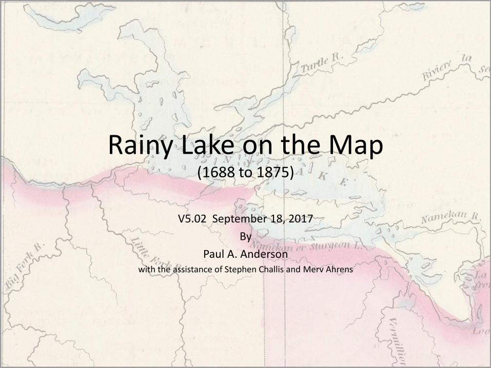
Rainy Lake on the Map(1688 to 1875)
V5.02 September 18, 2017
By
Paul A. Andersonwith the assistance of Stephen Challis and Merv Ahrens
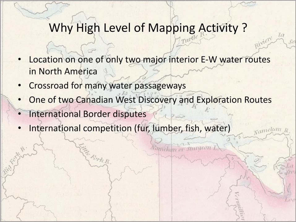
Why High Level of Mapping Activity ?
• Location on one of only two major interior E-W water routes in North America
• Crossroad for many water passageways
• One of two Canadian West Discovery and Exploration Routes
• International Border disputes
• International competition (fur, lumber, fish, water)
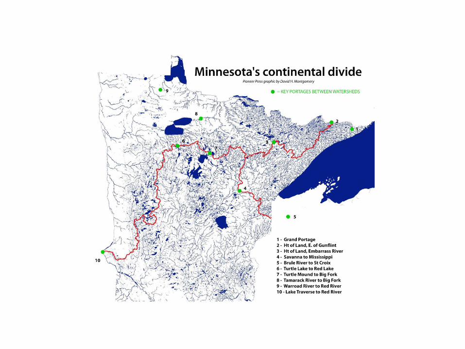

Strategic Portages to Cross Watershed Boundaries in Minnesota
Portage Name Watershed Connection Connecting Bodies of Water Distance Lat,Long
None Upper/Lower Red Lake to Big Fork/Rainy River
Upper Red L. to Tamarack R. to Sturgeon R. to Big Fork R.
4.3 miles 48.2025,-94.2813
Height of Land St Louis River to Vermilion River/Rainy Lake
Embarrass R to Pike River to Lake Vermilion
4.5 miles 47.651,-92.2929
Turtle Lake Portage
Upper Mississippi to Upper/Lower Red Lake
Turtle L to Lake Julia to Mud R 0.6 miles 47.6552,-94.8878
Grand Portage Lake Superior to Rainy River Headwaters
Lake Superior to Pigeon River(portage into Rainy watershed at 500 yd Height of Land just east of Gunflint Lake)
8.5 miles 47.9964,-89.7342
Savanna Portage
St Louis River to Mississippi Grand Rapids
East Savanna to West Savanna River to Big Sandy Lake
6 miles 46.8375,-93.1567
Turtle Mound Portage
Upper Mississippi to Big Fork/Rainy River
Cut Foot Sioux to Bowstring Lake to Dora Lake
4 miles 47.5353,-94.007
Bois Brule-St. Croix Portage
Lake Superior to Upper St Croix
Brule R. to Upper St Croix Lake 2.2 miles 46.3814,-91.7762
None Minnesota/Mississippi to Red River
Little Minnesota R. portage to Lake Traverse to Bois des Sioux R. to Red
0.8 miles 45.6066,-96.8533
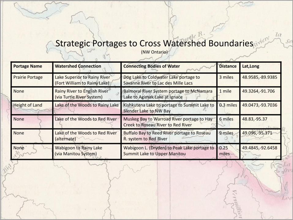
Strategic Portages to Cross Watershed Boundaries(NW Ontario)
Portage Name Watershed Connection Connecting Bodies of Water Distance Lat,Long
Prairie Portage Lake Superior to Rainy River(Fort William to Rainy Lake)
Dog Lake to Coldwater Lake portage to Savanne River to Lac des Mille Lacs
3 miles 48.9585,-89.9385
None Rainy River to English River(via Turtle River System)
Balmoral River System portage to McNamara Lake to Agimak Lake at Ignace
1 mile 49.3264,-91.706
Height of Land Lake of the Woods to Rainy Lake Kishkutena Lake to portage to Summit Lake to Slender Lake to NW Bay
0.3 miles 49.0473,-93.7036
None Lake of the Woods to Red River Muskeg Bay to Warroad River portage to Hay Creek to Roseau River to Red River
6 miles 48.83,-95.37
None Lake of the Woods to Red River(alternate)
Buffalo Bay to Reed River portage to Roseau R. system to Red River
9 miles 49.096,-95.371
None Wabigoon to Rainy Lake(via Manitou System)
Wabigoon L. (Dryden) to Peak Lake portage to Summit Lake to Upper Manitou
0.25 miles
49.4845,-92.6458

RAINY CANOE ROUTES
Lac Seul via Turtle River
Dryden Area via Manitou
LOW via “Back Road”
Lake Superior via multiple routesLake Vermillion
via Little Fork
LOW via Rainy River
Mississippi River
via Big Fork
Atikokan Area via Seine River
Manitou Area via Trout River

Key MapsMap/Author Region Year
Franquelin Great Lakes/New France 1688
DeLisle North America 1722
Ochagach Lake Superior to Lake Winnipeg 1730
La Veranderie Lake Superior to Lake Winnipeg 1740
Mitchell North America 1755
Carver Interior North America 1779
Pond NW Canada 1785
Arrowsmith North America 1802
Cary Upper and Lower Canada 1807
Thompson Lake Superior to Rockies 1813
Farmer Michigan/Wisconsin Territories 1830
Palliser Lake Superior to Rockies 1857
Dawson Lake Superior to Red River 1870
Stieler State of Minnesota 1875

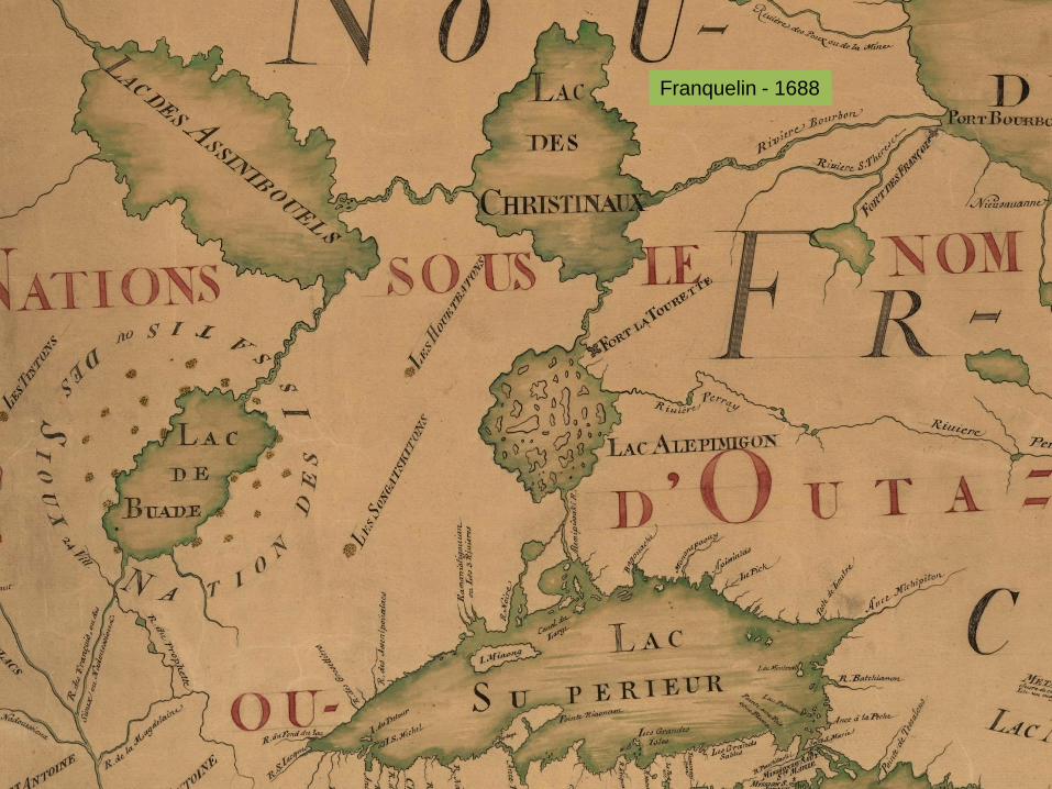
Franquelin - Great Lakes/New France - 1688
Background
The King's hydrographer and cartographer Jean-Baptiste-Louis Franquelin submitted this map to the
French authorities in 1688, in response to the Court's request to establish the borders between New France and New England.
Names, Features and Errors
• Great Lakes and Mississippi River fairly accurately placed
• No features in Rainy Lake Region
• LAC DES CRISTINAUX may represent Rainy Lake (De Noyon called Rainy Cristinaux)
• LAC DE BUADE represents Lake Mille Lacs, Red Lake, or Leech
Franquelin - 1688

DeLisle - North America - 1722
Background
DeLisle is important as the first "scientific" cartographer who incorporated the most current information
on exploration and topography into his maps. His maps of North America contain many innovations: discarding the fallacy of California as an island, first naming of Texas, first correct delineation of the Mississippi Valley, and first correct longitudes of North America. One of the most important maps published in the 18th century. So detailed was it for its day that this map was used as a template by many cartographers over the next 100 years.
Names, Features and Errors
• Few features in Western Canada
• First Time Rainy Lake is noted with certainty (Lac Tacamamioiien), not shown on 1703 DeLisle Map
• Mississippi River source and Rainy Lake are placed too far North
• Indications of canoe routes to Rainy from Mississippi Basin and Thunder Bay area

DeLisle - 1722
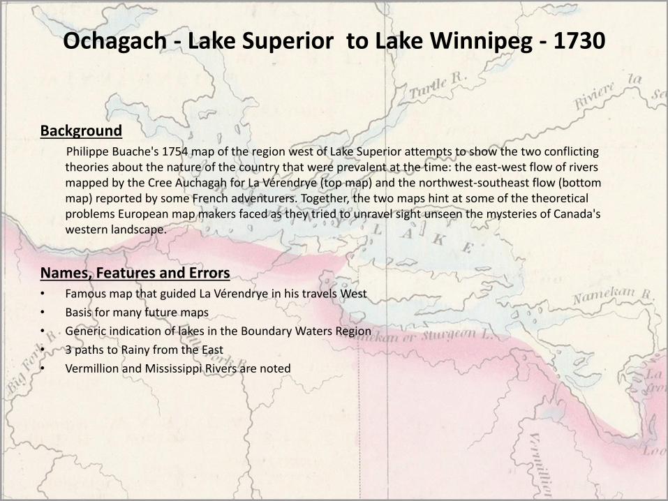
Ochagach - Lake Superior to Lake Winnipeg - 1730
BackgroundPhilippe Buache's 1754 map of the region west of Lake Superior attempts to show the two conflicting theories about the nature of the country that were prevalent at the time: the east-west flow of rivers mapped by the Cree Auchagah for La Vérendrye (top map) and the northwest-southeast flow (bottom map) reported by some French adventurers. Together, the two maps hint at some of the theoretical problems European map makers faced as they tried to unravel sight unseen the mysteries of Canada's western landscape.
Names, Features and Errors• Famous map that guided La Vérendrye in his travels West
• Basis for many future maps
• Generic indication of lakes in the Boundary Waters Region
• 3 paths to Rainy from the East
• Vermillion and Mississippi Rivers are noted

About 1730

La Veranderie - Lake Superior to Lake Winnipeg - 1740
BackgroundAs is the case with earlier La Veranderie maps, this one should be viewed along the north-south line in order to gain the most understandable impression. This configuration of lakes and rivers is the most significant, and most copied of all the maps resulting from the French trading venture. The border Lakes form a more correct angle with Manitoba Lakes, and Hudson Bay is more appropriately placed in relation to these features. However, there is still a large error in the distance shown between the Bay and the lakes.
Names, Features and Errors• Relative positions of Rainy Lake regional lakes and rivers are OK
• Generic indication of lakes
• French and HBC forts are placed on the map

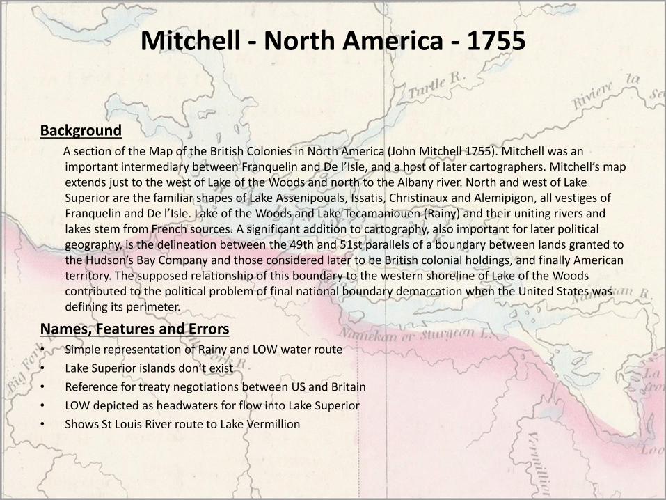
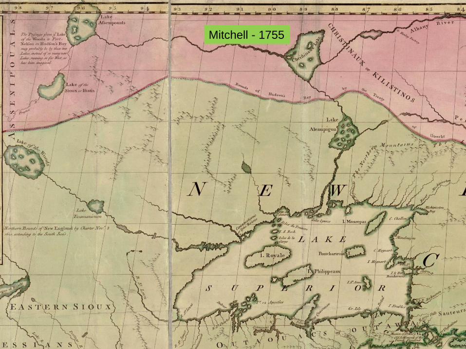
Mitchell - North America - 1755
BackgroundA section of the Map of the British Colonies in North America (John Mitchell 1755). Mitchell was an important intermediary between Franquelin and De l’Isle, and a host of later cartographers. Mitchell’s map extends just to the west of Lake of the Woods and north to the Albany river. North and west of Lake Superior are the familiar shapes of Lake Assenipouals, Issatis, Christinaux and Alemipigon, all vestiges of Franquelin and De l’Isle. Lake of the Woods and Lake Tecamaniouen (Rainy) and their uniting rivers and lakes stem from French sources. A significant addition to cartography, also important for later political geography, is the delineation between the 49th and 51st parallels of a boundary between lands granted to the Hudson’s Bay Company and those considered later to be British colonial holdings, and finally American territory. The supposed relationship of this boundary to the western shoreline of Lake of the Woods contributed to the political problem of final national boundary demarcation when the United States was defining its perimeter.
Names, Features and Errors• Simple representation of Rainy and LOW water route
• Lake Superior islands don’t exist
• Reference for treaty negotiations between US and Britain
• LOW depicted as headwaters for flow into Lake Superior
• Shows St Louis River route to Lake Vermillion
Mitchell - 1755

Carver - Interior N.A. - 1779
Background
Carver was the first Englishman to undertake an exploration of the west. His purpose was to map the land, to befriend the native Americans, and to discover the Northwest passage. His journey began in 1766 and, in some ways, was the precursor of the Lewis and Clark expedition; his book was the first popular American travel book.
Names, Features and Errors• Rainy Lake starts to take shape
• Basic representation of Border Lakes
• 2 Routes shown between Rainy and LOW
• Shows the Namakan River, but unnamed
• Shows St Louis River route to Rainy area

Carver - 1779
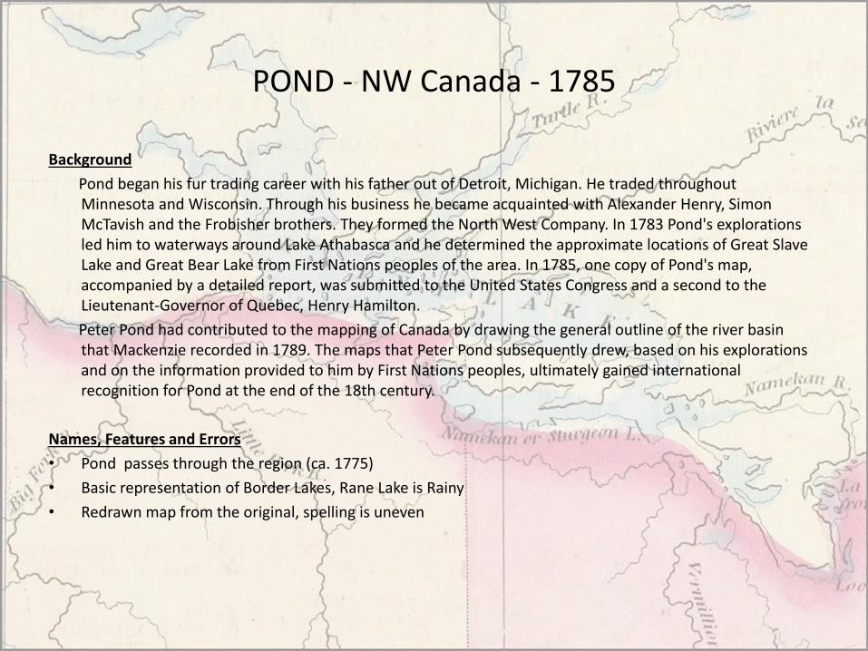
POND - NW Canada - 1785
Background
Pond began his fur trading career with his father out of Detroit, Michigan. He traded throughout Minnesota and Wisconsin. Through his business he became acquainted with Alexander Henry, Simon McTavish and the Frobisher brothers. They formed the North West Company. In 1783 Pond's explorations led him to waterways around Lake Athabasca and he determined the approximate locations of Great Slave Lake and Great Bear Lake from First Nations peoples of the area. In 1785, one copy of Pond's map, accompanied by a detailed report, was submitted to the United States Congress and a second to the Lieutenant-Governor of Quebec, Henry Hamilton.
Peter Pond had contributed to the mapping of Canada by drawing the general outline of the river basin that Mackenzie recorded in 1789. The maps that Peter Pond subsequently drew, based on his explorations and on the information provided to him by First Nations peoples, ultimately gained international recognition for Pond at the end of the 18th century.
Names, Features and Errors
• Pond passes through the region (ca. 1775)
• Basic representation of Border Lakes, Rane Lake is Rainy
• Redrawn map from the original, spelling is uneven

POND - 1787
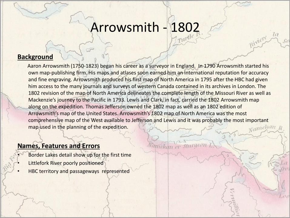
Arrowsmith - 1802
BackgroundAaron Arrowsmith (1750-1823) began his career as a surveyor in England. In 1790 Arrowsmith started his own map-publishing firm. His maps and atlases soon earned him an international reputation for accuracy and fine engraving. Arrowsmith produced his first map of North America in 1795 after the HBC had given him access to the many journals and surveys of western Canada contained in its archives in London. The 1802 revision of the map of North America delineates the complete length of the Missouri River as well as Mackenzie’s journey to the Pacific in 1793. Lewis and Clark, in fact, carried the 1802 Arrowsmith map along on the expedition. Thomas Jefferson owned the 1802 map as well as an 1802 edition of Arrowsmith’s map of the United States. Arrowsmith’s 1802 map of North America was the most comprehensive map of the West available to Jefferson and Lewis and it was probably the most important map used in the planning of the expedition.
Names, Features and Errors• Border Lakes detail show up for the first time
• Littlefork River poorly positioned
• HBC territory and passageways represented

Arrowsmith - 1802

Cary - Upper and Lower Canada - 1807
BackgroundMap shows Upper and Lower Canada from the St. Lawrence estuary to Lake Winnipeg during the heyday of the Canadian fur trade and the Hudson's Bay Company, with many engraved place names as well as commentary.
Names, Features and Errors• Rainy shape remains generalized
• Minnesota - Canada border is distorted
• New names (English) for lakes East of Rainy
• “Back Road” identified from LOW to Rainy
• Falls at Rainy outlet named “Kettle Falls”

Cary - 1807
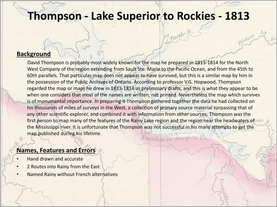
Thompson - Lake Superior to Rockies - 1813
BackgroundDavid Thompson is probably most widely known for the map he prepared in 1813-1814 for the North West Company of the region extending from Sault Ste. Marie to the Pacific Ocean, and from the 45th to 60th parallels. That particular map does not appear to have survived, but this is a similar map by him in the possession of the Public Archives of Ontario. According to professor V.G. Hopwood, Thompson regarded the map or maps he drew in 1813-1814 as preliminary drafts, and this is what they appear to be when one considers that most of the names are written, not printed. Nevertheless the map which survives is of monumental importance. In preparing it Thompson gathered together the data he had collected on his thousands of miles of surveys in the West, a collection of primary source material surpassing that of any other scientific explorer, and combined it with information from other sources. Thompson was the first person to map many of the features of the Rainy Lake region and the region near the headwaters of the Mississippi river. It is unfortunate that Thompson was not successful in his many attempts to get the map published during his lifetime.
Names, Features and Errors• Hand drawn and accurate
• 2 Routes into Rainy from the East
• Named Rainy without French alternatives

Thompson - 1813

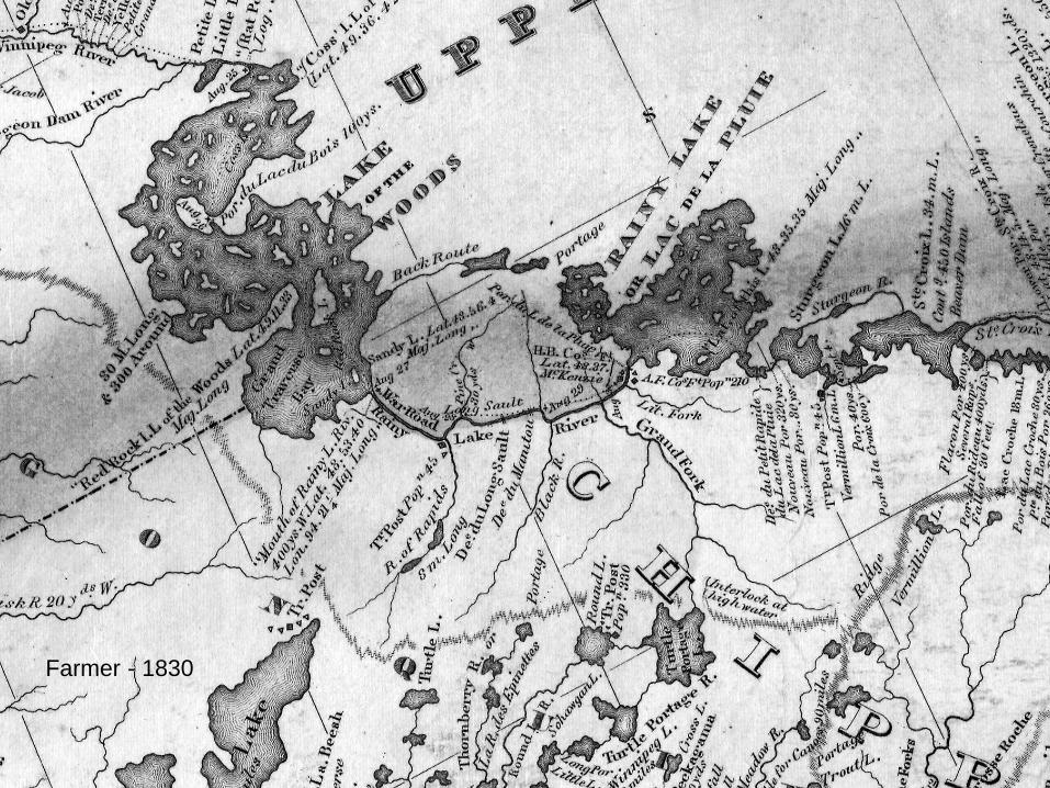
Farmer - Michigan/Wisconsin Territories - 1830
Background
John Farmer’s map has an unique orientation that enabled him to include the large area under the nominal jurisdiction of Michigan. His excellent engraver was able to include a great deal of information from Henry Schoolcraft and Major Long about the Lake Superior region. An extraordinary amount of information about Native American populations appears on this map.
Names, Features and Errors• High level of regional detail (from Major Stephen H. Long’s 1823 Border Survey Expedition)
• Trading posts are identified, portage lengths noted
• Names Sturgeon Lake and River
Farmer - 1830
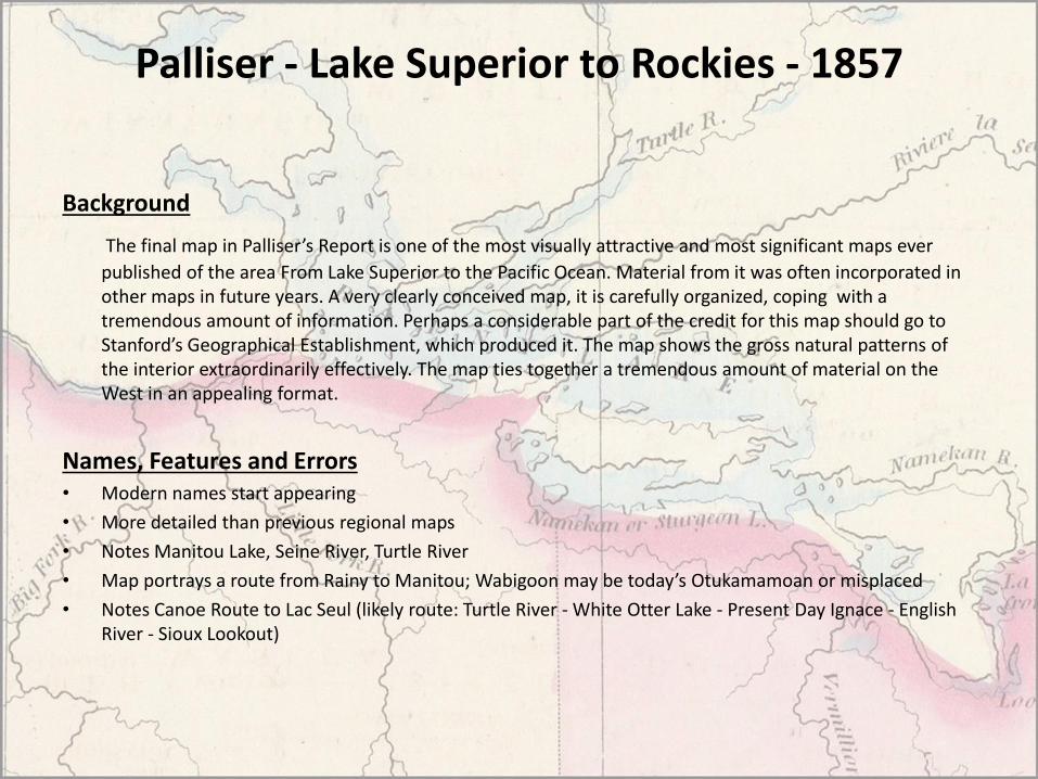
Palliser - Lake Superior to Rockies - 1857
Background
The final map in Palliser’s Report is one of the most visually attractive and most significant maps ever
published of the area From Lake Superior to the Pacific Ocean. Material from it was often incorporated in other maps in future years. A very clearly conceived map, it is carefully organized, coping with a tremendous amount of information. Perhaps a considerable part of the credit for this map should go to Stanford’s Geographical Establishment, which produced it. The map shows the gross natural patterns of the interior extraordinarily effectively. The map ties together a tremendous amount of material on the West in an appealing format.
Names, Features and Errors• Modern names start appearing
• More detailed than previous regional maps
• Notes Manitou Lake, Seine River, Turtle River
• Map portrays a route from Rainy to Manitou; Wabigoon may be today’s Otukamamoan or misplaced
• Notes Canoe Route to Lac Seul (likely route: Turtle River - White Otter Lake - Present Day Ignace - English River - Sioux Lookout)

Palliser - 1857

Dawson - Lake Superior to Red River - 1870
Background
The map shows the route between Lake Superior and Red River Settlement and was compiled from S.J. Dawson's exploratory surveys, and maps in Depart. Of Crown Lands O. By A.L. Russell. It was decided to use the northwest canoe route as the line of advance for the Red River Expeditionary Force. Several variations of the old canoe system had been explored by S.J. Dawson, W.H. Napier, and H.Y. Hind. This map, drawn after the arrival of the troops at Fort Garry, shows the route actually traversed by Wolseley and his men in 1870. Russell has included such features as the road line from Fort Garry to Lake of the Woods and has added dates along the route, referring to the arrival of the first troops at each point. It is interesting to note that as a result of the travels of the expeditionary force, a considerable body of new knowledge was gathered concerning the geography of the region. Russell incorporated this new information into this map and as a result, produced the first truly accurate map of this section of NW Ontario.
Names, Features and Errors• Accurate portrayal of Rainy, some bays are distorted
• Details of canoe routes East of Rainy

Dawson - Lake Superior to Red River - 1870Dawson - 1870

Stieler - State of Minnesota - 1875
BackgroundStieler's Atlas is extraordinarily detailed. Close examination of the maps shows many features that one would expect to find only on much larger maps. This atlas was first published in 1817, with editions continuing well into the 20th century. It was one of the most comprehensive and best executed 19th century German atlases.
Names, Features and Errors• Approaches modern depiction of Rainy
• Turtle River named
• Elevations are shown
• Fort Francis (sp?)
• Falls at Rainy outlet named “Rainy Falls”

Stieler - 1875
Map References
• Historical Atlas of Manitoba http://www.flickr.com/photos/manitobamaps/collections/72157603367266295/
• David Rumsey Historical Map Collection http://www.davidrumsey.com/
• US Library of Congress http://memory.loc.gov/ammem/gmdhtml/dsxphome.html
• ACMLA http://www.ssc.uwo.ca/assoc/acml/maps.html
• Minnesota Historical Society
http://www.mnhs.org/library/
• McGill
http://digital.library.mcgill.ca/pugsley