RAILWAY LANDS WEST AND CENTRAL - Toronto DESIGN GUIDELINES June 2004 RAILWAY LANDS WEST AND CENTRAL...
32
June 2004 URBAN DESIGN GUIDELINES RAILWAY LANDS WEST AND CENTRAL TORONTO Re-development in the former railway lands will be consistent with the following urban design guidelines. The guidelines correspond to the Railways Lands West and Central in Sections 18 and 19 of Chapter 6 of the Official Plan. The guidelines are to be read in conjunction with the urban design policies of the Official Plan. LOCATION The Railway Lands West and Central is the area of the city generally bounded by Front Street, the Gardiner–Lake Shore Corridor, Bathurst Street and Simcoe Street. It includes SkyDome and the CN Tower at the east end, and abuts Front Street at its west. These urban design guidelines, are intended to provide a context for development of the lands into a predominantly residential neighbourhood for approximately 7,500 residential units, along with non-residential and entertainment uses, new streets, parks, schools, day cares and other amenities. The guidelines illustrate and describe an urban design framework, and provide a context for co- ordinated incremental development and for evaluating development applications. GUIDELINES These guidelines: Promote the highest quality of design Describe the anticipated approach to site planning, built form and amenity Provide a coordinated approach to the design and definition of the public realm Allow for a range of development scenarios, ownership patterns, architectural and landscape architectural expressions and phasing approaches. While these guidelines apply to the public realm for the entire Railway Lands West and Central, the blocks currently owned by the City of Toronto (18AB, 31, 32 and 36), Canada Lands Corporation (18C) and Wittington (33 and 37) continue to be governed by zoning by-laws passed in 1994.
Transcript of RAILWAY LANDS WEST AND CENTRAL - Toronto DESIGN GUIDELINES June 2004 RAILWAY LANDS WEST AND CENTRAL...

June 2004URBAN DESIGN GUIDELINES
RAILWAY LANDS WEST AND CENTRAL
TORONTO
Re-development in the former railway lands will beconsistent with the following urban designguidelines. The guidelines correspond to the RailwaysLands West and Central in Sections 18 and 19 ofChapter 6 of the Official Plan. The guidelines are tobe read in conjunction with the urban designpolicies of the Official Plan.
LOCATIONThe Railway Lands West and Central is the area ofthe city generally bounded by Front Street, theGardiner–Lake Shore Corridor, Bathurst Street andSimcoe Street. It includes SkyDome and the CNTower at the east end, and abuts Front Street at itswest. These urban design guidelines, are intended toprovide a context for development of the lands intoa predominantly residential neighbourhood forapproximately 7,500 residential units, along withnon-residential and entertainment uses, new streets,parks, schools, day cares and other amenities.
The guidelines illustrate and describe an urbandesign framework, and provide a context for co-ordinated incremental development and forevaluating development applications.
GUIDELINESThese guidelines:
� Promote the highest quality of design
� Describe the anticipated approach to siteplanning, built form and amenity
� Provide a coordinated approach to the designand definition of the public realm
� Allow for a range of development scenarios,ownership patterns, architectural and landscapearchitectural expressions and phasing approaches.
While these guidelines apply to the public realm forthe entire Railway Lands West and Central, theblocks currently owned by the City of Toronto(18AB, 31, 32 and 36), Canada Lands Corporation(18C) and Wittington (33 and 37) continue to begoverned by zoning by-laws passed in 1994.

June 2004 URBAN DESIGN GUIDELINESTORONTO
RAILWAY LANDS WEST AND CENTRAL
Bremner
SkyDome
BREMNER
The Railway Lands Location Map 1
Block Map Map 2

June 2004URBAN DESIGN GUIDELINES
RAILWAY LANDS WEST AND CENTRAL
TORONTO
SITE PLAN REVIEW AND DEVELOPMENTCONTEXT PLANThe Railway Lands West and Central SecondaryPlans require that a Development Context Plan beprepared as a part of any site plan application toprovide context, ensure coordinated incrementaldevelopment, and assist City Council in evaluatingsite plan applications. The Development ContextPlan will assist the City in coordinating newdevelopments with existing and anticipateddevelopments in the vicinity, and will be reviewed bythe ongoing Urban Design and EnvironmentAdvisory Group for the Railway Lands, as well asCity staff.
The City has developed a Public Art Master Plan forthe Railway Lands West and Central identifyingopportunities and priorities for the Public Artprogram on these lands as a companion to theseurban design guidelines.
CN Tower
BREMNER
Task Force Mandate Map Map 3

June 2004
HISTORY AND SIGNIFICANCE OF THE SITEThe Railway Lands historically were occupied by raillines and railway related infrastructure as passengerand freight access to the city was focused on thewater. As industry and related freight services movedout of the city core, plans began to evolve for this areato permit more urban uses and to provide connectionsfrom the central city to the waterfront. Along with thenumerous opportunities to acknowledge the railwayheritage of this site as it develops, the Railway Landsalso includes parts of the former shoreline of LakeOntario and the mouth of Garrison Creek.
URBAN DESIGN GUIDELINESTORONTO
RAILWAY LANDS WEST AND CENTRAL
figure 1

June 2004URBAN DESIGN GUIDELINES
RAILWAY LANDS WEST AND CENTRAL
TORONTO
THE STRUCTURE PLANThe structure plan (Map 4) summarizes the urbandesign objectives for the area and shows thisneighbourhood in the context of the Harbourfront,Bathurst–Strachan and King–Spadina districts.
MAP B
QUEEN’S QUAY
OldFort York
BREMNER
Structure Plan for Urban Design Guidelines Map 4

URBAN DESIGN GUIDELINESTORONTO
RAILWAY LANDS WEST AND CENTRAL
June 2004
OBJECTIVES
Objective 1: Parks and Open Space SystemsThe Railway Lands West and Central are structuredaround a system of high quality useable, linkedparks, open spaces and setbacks which providespatial relief to, and appropriate settings for,adjacent development.
An Open Space Master Plan has been prepared as apart of these guidelines which illustrates thelocation of existing and future open spaces, bothpublic and privately owned, and indicates how andwhere connections should be made (see Map 10).
The connected system of parks and open spaces willconsist of a variety of spaces and extend existingcity patterns wherever possible. Optimummicroclimate, noise and vibration conditions will beachieved throughout the system.
Open Spaces

Objective 2: Connections to the CityAn important objective in developing the RailwayLands West and Central is to unite the central citywith the waterfront by extending the urban patternsouthwards towards the waterfront and by thedecreasing the impact of the existing Rail Corridorand Gardiner Expressway barriers. This is combinedwith the objective to create a new neighbourhoodwith a strong sense of place centred at theintersection of Spadina Avenue and Bremner–Boulevard / Bremner Extension.
To support this objective, development will:
� Strive to have public infrastructure in place asearly as possible, recognizing its key role increating a positive public realm
� Provide a continuous public realm linking to theKing-Spadina neighbourhood, HarbourfrontRailway Lands East and Bathurst–Strachan
URBAN DESIGN GUIDELINES
RAILWAY LANDS WEST AND CENTRAL
TORONTOJune 2004
� Establish Bremner Boulevard and its extension asa significant public street acting as an east-westspine for the entire Railway Lands
� Incorporate Bremner Boulevard and its extensionas a new street joining the major open spaces inthe Railway Lands and acting as an address forpublic buildings and community facilities in thedistrict, in addition to its functional role ofproviding frontage for new development andaccommodating pedestrians, cyclists, publictransit and private vehicles.
Street Pattern
June 2004 URBAN DESIGN GUIDELINESTORONTO
RAILWAY LANDS WEST AND CENTRAL
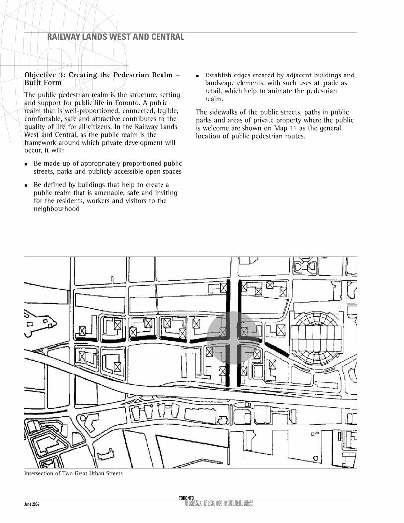
Objective 3: Creating the Pedestrian Realm –Built FormThe public pedestrian realm is the structure, settingand support for public life in Toronto. A publicrealm that is well-proportioned, connected, legible,comfortable, safe and attractive contributes to thequality of life for all citizens. In the Railway LandsWest and Central, as the public realm is theframework around which private development willoccur, it will:
� Be made up of appropriately proportioned publicstreets, parks and publicly accessible open spaces
� Be defined by buildings that help to create apublic realm that is amenable, safe and invitingfor the residents, workers and visitors to theneighbourhood
� Establish edges created by adjacent buildings andlandscape elements, with such uses at grade asretail, which help to animate the pedestrianrealm.
The sidewalks of the public streets, paths in publicparks and areas of private property where the publicis welcome are shown on Map 11 as the generallocation of public pedestrian routes.
Intersection of Two Great Urban Streets

URBAN DESIGN GUIDELINES
RAILWAY LANDS WEST AND CENTRAL
TORONTOJune 2004
GUIDELINES FOR BUILT FORM
ObjectivesThe aim of the built form guidelines is to achievethe following.
� Ensure adequate street walls through appropriatebase building heights adjacent to public streetsand open spaces.
� Built form will recognize Spadina Avenue andBremner Boulevard / Bremner Extension as theprincipal spines to the new neighbourhood, andtheir intersection as a significant place.
� Allow for flexibility within the Zoning By-lawenvelopes (see figure illustrating the buildingenvelopes).
� Allow for architectural expression and permit highquality architectural design, particularly on thelandmark tower on Block 22, through designcompetitions, wherever possible.
� Create “gateways” to the neighbourhood at theintersections of Spadina Avenue and Front Streetand Spadina Avenue at Lake Shore Boulevard Westwith streetwalls and towers to clearly define thepublic realm at both the pedestrian and cityscapescales.
� Contribute to mitigating against the impact ofthe Gardiner Expressway and the Rail Corridorthrough building massing.
� Arrange towers to allow views through the RailwayLands, frame open spaces, and create gateways.
Participation in Design� The use of one architect to design multiple
buildings is not appropriate and will not achievethe objective of these guidelines.
� The use of multiple architects will ensure diversityin architectural styles in the context of a co-ordinated development plan.
� A single architect may design individual projectsacross the street from each other to create asense of cohesive containment and to generate a“gateway” where appropriate.
� Over time, the entire Railway Lands West andCentral will be the result of the collaborativeeffort of many architectural firms.
Zoning Envelope

June 2004
BUILT FORM GUIDELINES
Build-to ZoneThe Railway Lands include build-to zones alongmajor streets, which ensure that buildings willprovide a substantial presence along the build-toposition at the street edge. The exception to thisprinciple is on Bathurst Street north of BremnerBoulevard Extension where the “street wall” hasbeen eroded to open the site to the street for theinterpretation of historic Garrison Creek and toimprove views from Fort York’s “West Gate” towardthe skyline view of the financial district towers.Where the lot is not fronted with buildings,additional building or landscape elements will beconsidered to define the edge of the public realm.
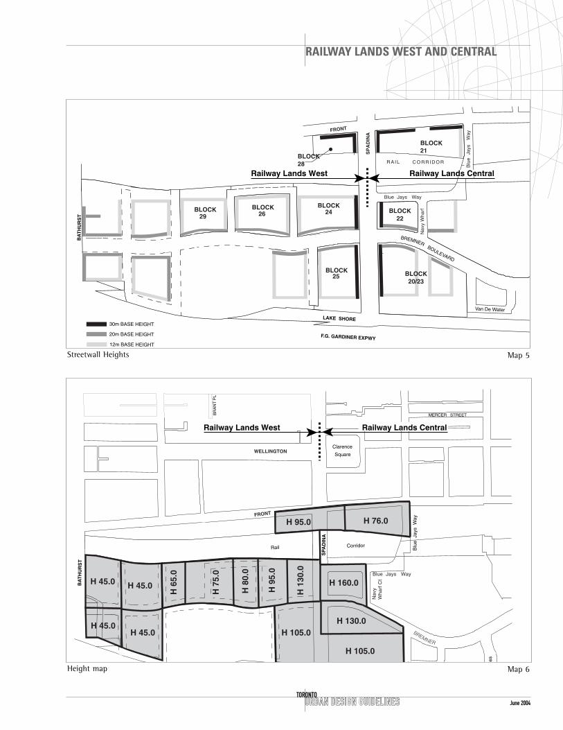
Street Wall HeightAn appropriate street wall height depends on manyfactors, including the width and intended characterof the street. The Railway Lands Zoning By-law setsout minimum and maximum street wall heights fornew buildings. Within this range of heights, theurban design guidelines include a preferred streetwall height that reflects the scale and importance ofeach street.
Spadina Avenue and Bremner Boulevard and itsextension are two generously scaled streets, whichtraverse the Railway Lands, north-south and east-west. These unifying elements of the plan will havethe characteristics of great urban boulevardsincluding well-defined edges, lively uses andattractive sidewalks. A strong and continuous streetwall system will be established for these two streets.Building setbacks along the north side of theBremner Boulevard / Bremner Extension will followthe curve of the street.
The public realm will be defined with the followingappropriate street wall heights:
� 12 metres on side streets
� 20 metres on the Bremner Boulevard / BremnerExtension and Dan Leckie Way (between BremnerBoulevard / Bremner Extension and Lake ShoreBoulevard)
� 30 metres on Spadina Avenue and Front Street.
URBAN DESIGN GUIDELINESTORONTO
RAILWAY LANDS WEST AND CENTRAL
Spadina Avenue street wall from College Street to Front Street
Leslie Frost Building following the curve of Queens Park Crescent
June 2004URBAN DESIGN GUIDELINES
RAILWAY LANDS WEST AND CENTRAL
TORONTO
Van De Water
R A I L C O R R I D O R
BLOCK BLOCK20/23
BLOCK22
BLOCK21
BLOCK28
25
29BLOCK
26BLOCK
24BLOCK
Railway Lands West Railway Lands Central
Nav
y W
harf
Blu
e J
ays
W
ay
Blue Jays Way
SP
AD
INA
LAKE SHORE
BA
TH
UR
ST
F.G. GARDINER EXPWY
FRONT
30m BASE HEIGHT
20m BASE HEIGHT
12m BASE HEIGHT
BREMNERBOULEVARD
BR
AN
T P
L
H 76.0H 95.0
H 160.0
H 130.0
H 105.0
H 105.0
H 45.0
H 45.0
H 45.0
H 45.0
H 6
5.0
H 7
5.0
H 8
0.0
H 9
5.0
H 1
30.0
ees
MERCER STREET
Clarence
Square
Rail Corridor
Nav
yW
harf
Ct
Blu
e J
ays
Way
V D
Blue Jays Way
BA
TH
UR
ST
SPA
DIN
A
FRONT
WELLINGTON
BREMNER
Railway Lands West Railway Lands Central
Height map Map 6
Streetwall Heights Map 5

URBAN DESIGN GUIDELINESTORONTO
RAILWAY LANDS WEST AND CENTRAL
June 2004
Corner Building at King Street and Springhurst
Corner Expression
Typical Victorian Toronto local street
Spadina Avenue
� The built form guidelines recommend a streetwall height of 30 metres for 75% of the frontageof base buildings along Spadina Avenue and amaximum of 35 metres. This ensures compatibilitywith the King-Spadina built form to the north.
Bremner Boulevard / Bremner Extension and Dan Leckie Way
� A street wall height of 20 metres is recommendedfor the north side of Bremner Boulevard /Bremner Extension and Dan Leckie Way. Alongthese streets, a minimum of 66% of the blockfrontage must be occupied with a building, andthe maximum height for a base building is 26metres.
Corner Conditions: Spadina and Front, Spadinaand Bremner Boulevard / Bremner Extension
� A zone extending 18 metres to either side of thebuilding envelope corner will be developed in aparticular manner other than that which governsthe respective constituent streets, as long asadequate wind deflection and pedestrian weatherprotection is maintained.
� At the intersection of Bremner Boulevard /Bremner Extension and Spadina Avenue, modifiedbuild-to requirements permit more flexibility andallow for a range of massing alternatives. The minimum percentage of build-to is increasedfrom 75% to 90% to ensure that the corners aredefined and occupied.
Local Streets
� The recommended street wall height for buildingsalong minor north-south streets is 12 metres.
� Buildings constructed on these frontages willform generally contiguous facades at the build-tozones within the 12 to 18 metre height zone.
� Individual expression of buildings is encouragedthrough the provision of a two-metre lateral zonefor the build-to. At grade, this zone will allow forthe building of porches, stoops and otherresidential building elements appropriate forgrade accessible units that are encouraged inthese locations. Above grade, this allows for theprovision of habitable bay windows and otherresidential building elements.

URBAN DESIGN GUIDELINES
RAILWAY LANDS WEST AND CENTRAL
TORONTOJune 2004
Building MassingBuilding elements rising above the street wallheights may be the source of undesirable windeffects which could, at least locally, compromisesunlight and sky exposure. Street wall buildings andother lower building elements can mitigate againstthe effects of tall building downdrafts. Tallerbuilding elements above the base building heightwill be reviewed in conjunction with therequirements for the street wall and base buildingson each block.
Setback
� Buildings rising above the maximum street wallheight will step back a minimum of two metresfrom the street wall, to ensure that the primarydefinition of the street is in proportion with thewidth of the street and that the adjacent streetsand open spaces are protected from adverse wind effects.
Cornices
� The consistent use of such architectural elementsas a cornice and belt courses on individual streetwall buildings is encouraged.
� These types of elements can provide for theharmonious composition of several buildings intoa single street wall and when they are applied tobuildings on opposing sides of the street, willhelp to unify the space between the buildings.
� The general location for these elements is up toindividual builders and will be examined at thetime of site plan review.
� To allow for building articulation, reveals andvariations in the thickness of constructionmaterials, all build-to zones allow for a buildingface to be located within a specific distance ofthe setback line. Depending upon which buildingface it is, this thickness is either 1.2 or 2.0 metres.
� Permitted projections are allowed into setbackareas for certain building elements includingcornices, canopies, lighting fixtures and otherbuilding elements.
� The design of adjacent buildings on the sameblock will be coordinated to provide continuity to any street wall elements such as canopies,arcades, and projecting cornices.
Section of Setbacks

June 2004 URBAN DESIGN GUIDELINESTORONTO
RAILWAY LANDS WEST AND CENTRAL
Towers
The relationship of tall buildings in the Railway LandsWest to others in adjacent areas is an importantconsideration. Tall buildings will develop architecturalcharacter and contribute to the visual coherence ofthe city. The greatest permitted building heights arealong Spadina Avenue and range in total heightbetween 95 and 160 metres. Height at these locationsis encouraged to assist in establishing SpadinaAvenue as a significant, processional street, and astreet of arrival to the city. A building of up to 160metres in height at the northeast corner of BremnerBoulevard / Bremner Extension and Spadina Avenuewill provide a landmark for other heights andbuildings in the area. All other heights descend fromthis location. An architectural competition will beheld for this building.
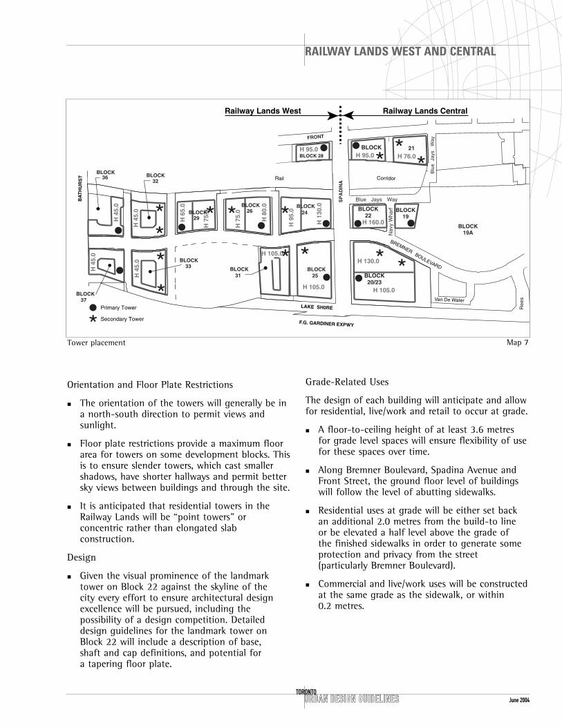
Tower locations have been coordinated to ensureviews from and across the Railway Lands. Map 7shows the preferred placement of towers to ensurelandmark elements, framing of public spaces, skylinecomposition, and coordinated views.
Location
� Most development blocks can accommodate morethan one tower. In each case, a primary and asecondary tower for each block will beestablished and placed to reflect the primary andsecondary streets in the area. Map 7 shows theirpreferred location.
� The position and shape of the towers will beconsidered as one composition to create urbandesign coherence, frame streets and parks, anddefine intersections.
� Significant pairings of towers are encouragedbetween Bremner Boulevard / Bremner Extensionand Lake Shore Boulevard and at Front Street.The design of each pair will create a gate atthese important threshold locations.
� Towers will be placed to form a cluster oppositethe two corners of the community park on thenorth side of Bremner Boulevard Extension.
Spadina Avenue with arcades
36-50 Lombard Street: well designed residential tower
June 2004URBAN DESIGN GUIDELINES
RAILWAY LANDS WEST AND CENTRAL
TORONTO
Railway Lands West Railway Lands Central
H 76.0H 95.0H 95.0
H 160.0
H 130.0
H 105.0H 105.0
H 105.0
H 4
5.0
H 4
5.0
H 4
5.0
H 4
5.0
H 6
5.0
H 7
5.0
H 7
5.0
H 8
0.0
H 9
5.0
H 1
30.0
Nav
y W
harf
Ree
s
Rail Corridor
Blue Jays Way
BLOCK22
BLOCK20/23
BLOCK 28
BLOCK 21
BLOCK31
BLOCK32
33
BLOCK BLOCK
BLOCK
2426
25
BLOCK37
BLOCK36
BLOCK
29BLOCK BLOCK
19
BLOCK19A
Van De Water
Blu
e J
ays
W
ay
SP
AD
INA
LAKE SH0RE
BA
TH
UR
ST
F.G. GARDINER EXPWY
FRONT
Primary Tower
Secondary Tower
BREMNERBOULEVARD
Tower placement Map 7
Orientation and Floor Plate Restrictions
� The orientation of the towers will generally be ina north-south direction to permit views andsunlight.
� Floor plate restrictions provide a maximum floorarea for towers on some development blocks. Thisis to ensure slender towers, which cast smallershadows, have shorter hallways and permit bettersky views between buildings and through the site.
� It is anticipated that residential towers in theRailway Lands will be “point towers” orconcentric rather than elongated slabconstruction.
Design
� Given the visual prominence of the landmarktower on Block 22 against the skyline of the city every effort to ensure architectural designexcellence will be pursued, including thepossibility of a design competition. Detaileddesign guidelines for the landmark tower onBlock 22 will include a description of base, shaft and cap definitions, and potential for a tapering floor plate.
Grade-Related Uses
The design of each building will anticipate and allowfor residential, live/work and retail to occur at grade.
� A floor-to-ceiling height of at least 3.6 metresfor grade level spaces will ensure flexibility of usefor these spaces over time.
� Along Bremner Boulevard, Spadina Avenue andFront Street, the ground floor level of buildingswill follow the level of abutting sidewalks.
� Residential uses at grade will be either set backan additional 2.0 metres from the build-to line or be elevated a half level above the grade of the finished sidewalks in order to generate someprotection and privacy from the street(particularly Bremner Boulevard).
� Commercial and live/work uses will be constructedat the same grade as the sidewalk, or within 0.2 metres.

June 2004 URBAN DESIGN GUIDELINESTORONTO
RAILWAY LANDS WEST AND CENTRAL
Grade related uses, Market Square
Pedestrian, Parking and Service EntrancesPedestrian Entrances
� The general location of principal pedestrianentrances is indicated on Map 8.
� Principal pedestrian entrances have been locatedaway from major intersections in order to avoidunnecessary congestion and conflict associatedwith pick-up and drop-off.
� Buildings on north-south streets will reflect thetopography of the site by having entrances at the same grade as the adjacent sidewalk.
� Residential units directly accessible from gradeare encouraged at the base of buildings alongstreets, in courtyards and at mid-block connectionsto assist in animating the public realm.
� The use of traditional elements like stoops, smallporches and gardens to provide privacy areencouraged at the base of taller apartmentbuildings on both street and lane faces, and oninterior courtyards.
Railway Lands West Railway Lands Central
Nav
y W
harf
Ree
s
Rail Corridor
Blue Jays Way
BLOCK22
BLOCK20/23
BLOCK28
BLOCK 21
BLOCK31
BLOCK32
33
BLOCKBLOCK
BLOCK
29BLOCK 24
26
25
BLOCK37
BLOCK36
BLOCK
Van De Water
Blu
e J
ays
W
ay
SP
AD
INA
LAKE SH0RE
BA
TH
UR
ST
F.G. GARDINER EXPWY
FRONT
Principal Pedestrian Entrances
BLOCK19
BLOCK18C BLOCK
18AB
BLOCK19A
BREMNERBOULEVARD
Location of principal pedestrian entrances Map 8
� It is intended that the final location of principalpedestrian entrances will be determined in thecontext of full site plan review for any given lot.All applicants will be expected to demonstrate acoordinated solution, which does not provideunnecessary congestion with adjacentdevelopment on the block.

June 2004URBAN DESIGN GUIDELINES
RAILWAY LANDS WEST AND CENTRAL
TORONTO
Parking and Service Entrances
� The general location of service and vehicularaccess has been identified on Map 9.
� Access to underground servicing and parking willtake place within the mass of buildings, not inopen space.
� Placement of exhaust vents will be incorporatedinto building faces at 2.0 metres or greater abovegrade, or remote from pedestrian activity.
Above-Grade Parking Garages� Above–grade parking garages will have animated
facing uses. These uses will occur for the full heightof the parking structure, and will resemble adjacentresidential or commercial buildings with respectto windows, entrances, materials, roof lines andgrade uses.
� The facing uses will be directly accessible forpedestrians from the adjacent public areas.
� The parking will be directly accessible forpedestrians from the street or adjacent publicareas.
Residential entrances, 942 Yonge Street on McAlpine Street
Vehicular service entrance integrated into the street wall
Railway Lands West Railway Lands Central
Nav
y W
harf
Ree
s
Rail Corridor
Blue Jays Way
BLOCK 22
BLOCK20/23
BLOCK28
BLOCK21
BLOCK31
BLOCK32
33
BLOCKBLOCK
BLOCK
29BLOCK 24
26
25
BLOCK37
BLOCK36
BLOCK
Van De Water
Blu
e J
ays
W
ay
SP
AD
INA
LAKE SH0RE
BA
TH
UR
ST
F.G. GARDINER EXPWY
FRONT
BREMNERBOULEVARD
Vehicular Access
Building Parcels
Location of parking and service entrances Map 9

June 2004
BLOCK SPECIFIC GUIDELINESThe following guidelines have been prepared toensure that site specific issues are addressed duringthe preparation of site plans for these blocks.
Block 20/23 (east side of Spadina Avenue))� The extension of the public street system through
Block 20/23 may be appropriate and will bereviewed at the time of site plan review.
� The design of the publicly accessible open spaceon the east edge of Block 20, will be coordinatedby Urban Development Services.
� Residential uses will have a landscaped setback of3.0 metres.
� Each retail space located on these blocks musthave a direct street-related entrance.
Block 21 and 28 (Front Street)� The Front Street parcels north of the rail corridor
help to visually define the north limit of theneighbourhood, and act as a gateway betweenthe neighbourhoods. The “pairing” of towers isencouraged at the Spadina and Front Streetintersection to create this gateway.
� These parcels are permitted to be commercial orresidential, and will include street-related retail.
� Careful shadow studies are required as part ofany submission on these blocks to examineimpact on the public realm along Front Street,Clarence Square and adjacent private developments.
� Views and pedestrian walkways will be continuousand consistent on both sides of Front Street.
Block 22 (Landmark Tower)� The design of this building by way of an open
design competition will be considered.
� Detailed design guidelines for the landmark toweron Block 22 include a requirement for distinctbase, shaft and cap definitions and potentials fora tapering floor plate.
URBAN DESIGN GUIDELINESTORONTO
RAILWAY LANDS WEST AND CENTRAL
Blocks 24 and 25 (west side of SpadinaAvenue))� Permission is maintained for an emergency access
route along the northern limit of Block 24.
� Each retail space on these blocks must have adirect street related entrance.
Blocks 26 and 29 (north of the Park)� Towers on these blocks north of the community
park will be placed to frame the park, and markits east and west limits (as shown on Map 7).
� Views from the park to the base building andtowers will be terminated architecturally.
� Entrances at grade will reflect the park design,entry points, and crosswalks.
� Permission is maintained for a lane along thenorthern limit of Block 29.

June 2004URBAN DESIGN GUIDELINES
RAILWAY LANDS WEST AND CENTRAL
TORONTO
GUIDELINES FOR THE PUBLIC REALM
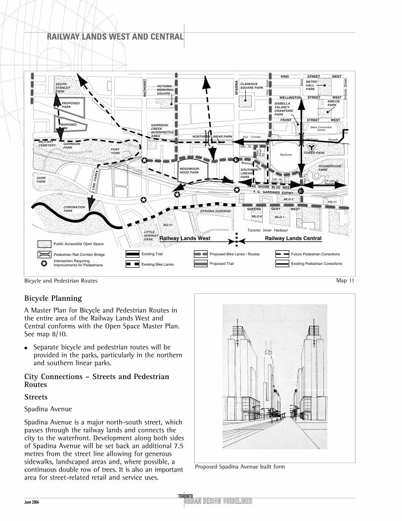
Parks and Open Space SystemsThe Open Space Master Plan for the Railway Landswest of SkyDome (Map 10) includes a full networkof parks, linkages into publicly accessible openspace, and public streets.
A plan for an interconnected system of bicycle andpedestrian routes within the Railway Lands is shownon (Map 11).
ViewsAll major view corridors and termini are indicated onthe Structure Plan (Map 4).
Central Community ParkThe community park located south of BremnerBoulevard / Bremner Extension between Dan LeckieWay and the proposed school/community centre isthe principal public open space in the Railway Landswest of Spadina Avenue. The Round House Park andthe Central Community Park are the two major publicplaces located along the serpentine BremnerBoulevard / Bremner Extension as it traverses theland between Fort York and the Air Canada Centre.
Program and Design Considerations
� Active and passive uses, (e.g. playing fields,strolling)
� Community centre programming, (e.g. outdoor classes, community events)
� School requirements, (e.g. hard and soft play areas)
� Preschool daycare requirements for secureoutdoor play space
� Hard and soft areas
� Adult and children’s programs
� Local circulation patterns and views
� Planting and greening
� Historic references, (e.g. shoreline)
� Storm water detention
Park Citroen, a 12 hectare park, is a green focus for anew district in Paris
Comparison of major urban parks in Toronto.
Allen Gardens
Queen’sPark

June 2004 URBAN DESIGN GUIDELINESTORONTO
RAILWAY LANDS WEST AND CENTRAL
Grading
� There is an approximately eight-metre change inelevation across the north-south section of thepark, and this could be used creatively in thedesign of the park.
� Any changes in grade across the park space willbe carried out in a manner that minimizes stairsand is accessible to everyone.
� The perimeter of the park will be maintained atthe same elevation as the adjacent streets.
View Corridor
� The 20-metre zone at the east end of thecommunity park will provide a view corridoracross the park to the Toronto Harbour south ofQueens Quay.
� This space will be designed as an extension atthe same level as the Nelson Mandela Boulevardsidewalk connecting to the southern linear park.
� This space will contain elements of the designlanguage of the adjacent public realm includingdecorative paving, pedestrian-scale lighting andstreet furnishing including benches, landscapeand bicycle storage.
� Any paved area necessary for service access to theadjacent block or park will be minimized andintegrated into the larger landscape design forthe space. The space will be accessible at all times.
Linear ParksIn addition to the Community Park, two linear parks(northern and southern) are planned within theRailway Lands West. They are to be consideredextensions of the public street system, and will betreated as streets with an address and visualoverlook.
Northern Linear Park
The northern linear park is south of the rail corridorand is intended for the interpretation of GarrisonCreek. The Garrison Creek system begins within theRailway Lands West (Block 36) where the oldshoreline met the creek (see Map 10). Interpretationof the mouth of the creek is proposed at thislocation to orient and commemorate this system.Northern linear park design strategies will include: aprivacy zone adjacent to residential uses; provisionfor pedestrian and bicycle passage; and coordinated tree and shrub planting.
� This linear park may have a private road toservice the adjacent development blocks on itssouthern 15 metres. The design will complementthe linear park’s primary role of providingpedestrian, bicycle circulation and landscapingthat will help provide a buffer to the rail corridor.
� The northern linear park will be defined anddesigned as a public route in its entirety.
� A lane along the northern limit of Block 32 willbe considered as an extension of the road system,and materials used in the lane will be the sameas those used in the park.
� Planting will be introduced along the northernlimit of the park, possibly a double row of trees.
� The design of the space will allow for informalplay areas for children.
� There will be no street or lane along the northernlimit of Block 36, immediately east of BathurstStreet.
Northern Linear Park - Blue Jay Way to Spadina Avenue

June 2004URBAN DESIGN GUIDELINES
RAILWAY LANDS WEST AND CENTRAL
TORONTO
Toronto Inner Harbour
CN Tower
KING
WELLINGTON
SP
AD
INA
Pet
er
S
tree
t
John
S
tree
t
QUEENS QUAY WEST
STREET WEST
Sta
F. G. GARDINER EXPWY
SkyDome
Ree
s S
t
Bremner Blvd
CP John StRoundhouse
Metro ConventionCentre
Skywalk
Peter St
Nav
y W
harf
C
t
Van deWater Cr
Rail Corridor
LAKE SHORE BLVD WEST
AV
EN
UE
BA
TH
UR
ST
ST
RE
E
STREET WEST
Sim
coe
S
tree
t
FRONT WESTSTREET
GORE PARK
LIN
K P
AR
K
MILITARYCEMETERY
GARRISONPARK
GARRISONCREEKINTERPRETIVEAREA
NEIGHBOUR-HOOD PARK
CLARENCESQUARE
LITTLENORWAYPARK
CORONATION PARK
FORTYORK
ROUNDHOUSEPARK
HARBOURCENTRE
TOWER PARK
ISABELLAVALENCIACRAWFORDPARK
BQ-11
MLQ-6
SOUTH LINEARPARK
MLQ-1
MLQ-2YQ-11
SPADINA GARDENS
NORTHERN LINEAR PARK
SOUTHSTANLEYPARK
VICTORIAMEMORIALSQUARE
AR
RIS
ON
CRE
EK
PROPOSEDPARK
PROPOSEDPARK
Railway Lands West Railway Lands Central
Public Accessible Open Space
Midblock Pedestrian Connections
Lands to be Leased or Conveyedto the City for Parks Purposes
General Location for Future Community Centre and Schools
Pedestrian Rail Corridor Bridge
Landscape Edge
Map 10
� Grade the northern linear park to permitconnections under the Bathurst Street bridge,under or over the Dan Leckie Way Bridgeabutment, under the Spadina Avenue Bridge, andconnections to the Garrison Creek system.
� The change in elevation from the finished parklevel and the railway track level will be either aretaining wall or absorbed as part of thelandscape design.
� The fire route along the northern limit of Block24, visually an extension of Blue Jay Way and anentrance into the northern linear park, will bedesigned to read as a public route, with standardcity pavers, lighting, curbs and benches. The fireaccess route will have a clear dimension of 6.0metres. A stair and/or ramp in this area willconnect the northern linear park under SpadinaAvenue.
Southern Linear Park
Adjacent to Lake Shore Boulevard, along the southedge of the Railway Lands West, a 12-metre widelinear park is proposed. Its role is to provide atransition between the development on the adjacentblocks and the Gardiner Expressway–Lake ShoreBoulevard Corridor and to connect the RoundhousePark, across Spadina Avenue, to the communitypark. The park will also provide an opportunity forpedestrian circulation, bicycle circulation and linkagebetween blocks, and in particular will link SpadinaAvenue, Globe Street and the Bathurst-Spadinacommunity park.
� The southern linear park will be graded to becompatible with adjacent development blocks andprovide barrier-free connections to all adjoiningpublic streets and parkland.
June 2004
Bicycle PlanningA Master Plan for Bicycle and Pedestrian Routes inthe entire area of the Railway Lands West andCentral conforms with the Open Space Master Plan.See map 8/10.
� Separate bicycle and pedestrian routes will beprovided in the parks, particularly in the northernand southern linear parks.
City Connections – Streets and PedestrianRoutes
StreetsSpadina Avenue
Spadina Avenue is a major north-south street, whichpasses through the railway lands and connects thecity to the waterfront. Development along both sidesof Spadina Avenue will be set back an additional 7.5metres from the street line allowing for generoussidewalks, landscaped areas and, where possible, acontinuous double row of trees. It is also an importantarea for street-related retail and service uses.
URBAN DESIGN GUIDELINESTORONTO
RAILWAY LANDS WEST AND CENTRAL
GORE PARK
MILITARYCEMETERY GARRISON
PARK
GARRISONCREEKINTERPRETIVEAREA
NEIGHBOUR-HOOD PARK
CLARENCESQUARE PARK
LITTLENORWAYPARK
CORONATIONPARK
FORTYORK
ROUNDHOUSEPARK
TOWER PARK
BQ-11
MLQ-1
MLQ-2YQ-11
SPADINA GARDENS
NORTHERN LINEAR PARK
SOUTHSTANLEYPARK
PROPOSEDPARK
PROPOSEDPARK
VICTORIAMEMORIALSQUARE
QUAY QUEENS
Toronto Inner Harbour
CN Tower
KING
WELLINGTON
SP
AD
INA
Pet
er
Str
eet
John
S
tree
t
STREET WEST
F. G. GARDINER EXPWY
SkyDome
Bremner Blvd.
CP John StRoundhouse
Metro ConventionCentre
Skywalk
Peter St
Nav
y W
harf
C
t
Van deWater Cr
Rail Corridor
LAKE SHORE BLVD WEST
BA
TH
UR
ST
STREET WEST
Sim
coe
Str
eet
FRONT WESTSTREET
Ree
s S
t
WEST
LIN
K P
AR
K
ISABELLAVALANCYCRAWFORDPARK
METROHALLPARK
SIMCOEPARK
MLQ-6
SOUTHERN LINEARPARK
Railway Lands West Railway Lands CentralPublic Accessible Open Space
Existing Trail
Existing Bike Lanes
Proposed Bike Lanes / Routes
Proposed Trail
Pedestrian Rail Corridor Bridge Future Pedestrian Conections
Existing Pedestrian Conections✪Intersection Requiring Improvements for Pedestrians
✪
✪
✪✪ ✪
✪
Bicycle and Pedestrian Routes Map 11
Proposed Spadina Avenue built form

June 2004URBAN DESIGN GUIDELINES
RAILWAY LANDS WEST AND CENTRAL
TORONTO
� The existing public sidewalk and the setbackfrom the street line will be treated as continuouslandscape space that reinforces pedestrianpassage to the waterfront.
� Conceptual “gateways” to the neighbourhood at theintersections of Spadina Avenue and Front Streetand Spadina Avenue at Lake Shore Boulevard willbe created through street design and adjacentbuilding design.
Bremner Boulevard / Bremner Extension
To facilitate its role as an east-west primary spine,the Bremner Boulevard / Bremner Extension right-of-way is wider than normal streets at 30 metres.This boulevard creates important intersections, linkspublic open spaces, is the address for publicinstitutions in the area, and accommodatespedestrians cyclists, public transit and privatevehicles. The intended landscape quality andpavement width for this street has been realized inthe section of Bremner Boulevard adjacent to theRound House Park between Rees Street and YorkStreet.
� A generous landscaped boulevard (approximately10 to 14 metres wide) is proposed along thenorth side of Bremner Boulevard / BremnerExtension and is meant to connect the openspaces with significant street tree-planting, cafes,benches and weather protection.
� Buildings on both sides of Bremner Boulevard /Bremner Extension will be set back and haveweather protection canopies and/or colonnadesat the significant corners.
Gardiner–Lake Shore Corridor
� All north south streets will be designed for futureextension across the Gardiner–Lake Shore Corridor.
Local Streets
New local north-south streets will serve as addressesfor adjacent development as well as connect thenorthern linear park to Bremner Boulevard / BremnerExtension.
� The minor streets and open spaces will benarrower, with less traffic, smaller sidewalks andlower-scaled buildings.
� Dan Leckie Way will continue as a bridge acrossthe rail corridor to Front Street, connectingnorthwards to the existing Portland Street, andsouthwards to Lake Shore Boulevard and Queen’sQuay. The local north-south streets betweenSpadina Avenue and Dan Leckie Way will connectsouth of the Bremner Extension into a publicpark.
St. Nicholas Street local street character

June 2004 URBAN DESIGN GUIDELINESTORONTO
RAILWAY LANDS WEST AND CENTRAL
� The proposed bridges at Dan Leckie Way, andapproximately midway between Dan Leckie Wayand Spadina Avenue, and the existing bridges atSpadina Avenue and Bathurst Street will be themajor pedestrian connectors to the waterfront.On these streets, buildings will be systematicallyset back, allowing for generous sidewalks,landscaped areas and, where possible, acontinuous double row of trees.
Weather Protection� A continuous colonnade or canopy will be built
along the length of Spadina Avenue from FrontStreet to Lake Shore Boulevard, including spacesbetween buildings and across the bridge. Uponsubmission of the context plan for this street, asingle and consistent treatment will bedetermined. The first building on either the eastor west side of Spadina will dictate whether thisentire section of street is arcades or canopies, inorder to ensure cohesiveness.
Railway Lands West Railway Lands Central
Rail Corridor
Nav
yW
harf
Ct
Blu
e J
ays
Way
Blue Jays WaySP
AD
INA
LAKE SHORE
BA
TH
UR
ST
F.G. GARDINER EXPWY
FRONT
BREMNERBOULEVARD
LOCATION OF CANOPIES
LOCATION OF COLONNADES
OR CANOPIESZONE FOR COLONNADES
BLOCK 28 BLOCK 21
BLOCK 20/23
BLOCK 222624
25
29BLOCK
36BLOCK
32BLOCK
37BLOCK
33BLOCK
BLOCKBLOCK
BLOCK31
BLOCK
Colonnades and Canopies Map 12

June 2004URBAN DESIGN GUIDELINES
RAILWAY LANDS WEST AND CENTRAL
TORONTO
� Weather protection along Bremner Boulevard /Bremner Extension beyond that which is requiredin the By-law is encouraged and could varydepending on the type of building facing thestreet.
� Colonnades or canopies must be provided at thefollowing corners: Bremner Boulevard / BremnerExtension and Spadina Avenue, and the BremnerExtension and Bathurst Street.
� Canopies will be permanent, well-maintained,and of the appropriate height and width.
� At the south edge of Blocks 22 and 25 alongSpadina Avenue adjacent to the Gardiner wherethere is no build-to requirement, a permanentcolonnade structure is preferred, which can eitherbe stand-alone as part of the park entrances orincorporated into a building.
� Bathurst Street and Spadina Avenue will eachhave a continuous colonnade system to provideweather-protected accesss across to thewaterfront.
� Bathurst Street may be reconstructed after thedevelopment of Blocks 36 and 37. Integratedcolonnades within the new development forpedestrian circulation are to be linked by bridgesto the existing Bathurst Street bridge as aninterim condition.
Spadina Avenue with continuous canopies
Continuous canopy: Dundas Street East
June 2004 URBAN DESIGN GUIDELINESTORONTO
RAILWAY LANDS WEST AND CENTRAL
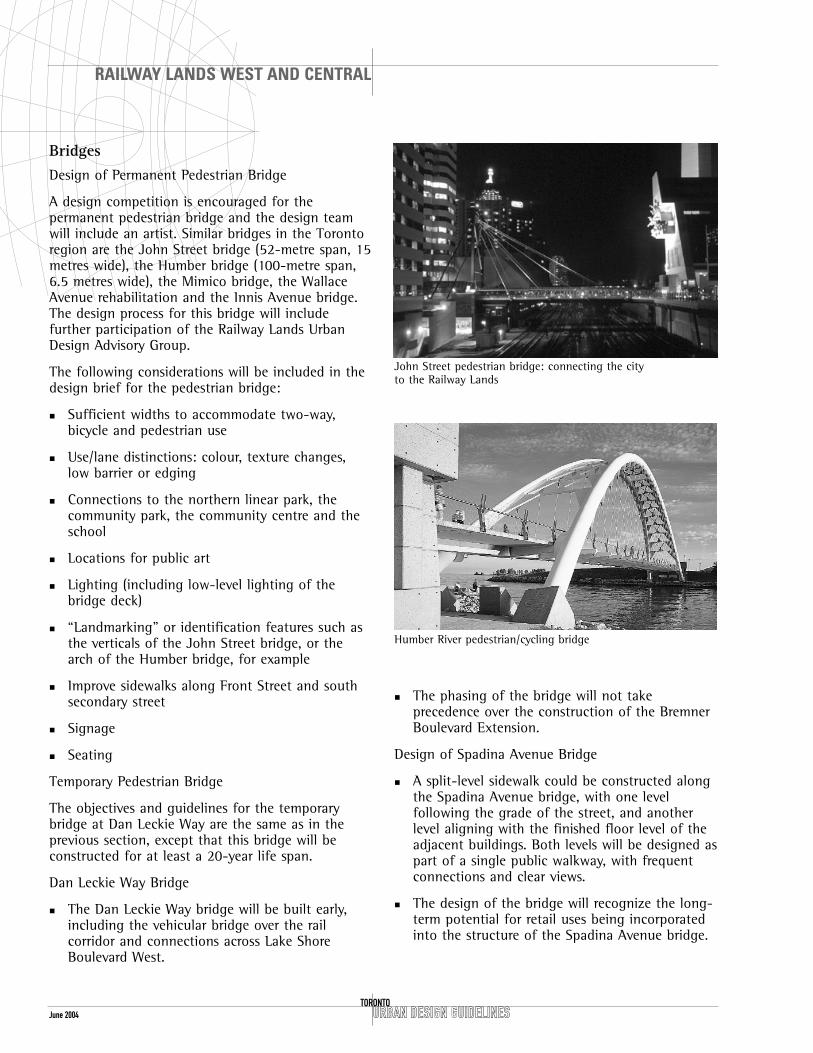
BridgesDesign of Permanent Pedestrian Bridge
A design competition is encouraged for thepermanent pedestrian bridge and the design teamwill include an artist. Similar bridges in the Torontoregion are the John Street bridge (52-metre span, 15metres wide), the Humber bridge (100-metre span,6.5 metres wide), the Mimico bridge, the WallaceAvenue rehabilitation and the Innis Avenue bridge.The design process for this bridge will includefurther participation of the Railway Lands UrbanDesign Advisory Group.
The following considerations will be included in thedesign brief for the pedestrian bridge:
� Sufficient widths to accommodate two-way,bicycle and pedestrian use
� Use/lane distinctions: colour, texture changes,low barrier or edging
� Connections to the northern linear park, thecommunity park, the community centre and theschool
� Locations for public art
� Lighting (including low-level lighting of thebridge deck)
� “Landmarking” or identification features such asthe verticals of the John Street bridge, or thearch of the Humber bridge, for example
� Improve sidewalks along Front Street and southsecondary street
� Signage
� Seating
Temporary Pedestrian Bridge
The objectives and guidelines for the temporarybridge at Dan Leckie Way are the same as in theprevious section, except that this bridge will beconstructed for at least a 20-year life span.
Dan Leckie Way Bridge
� The Dan Leckie Way bridge will be built early,including the vehicular bridge over the railcorridor and connections across Lake ShoreBoulevard West.
� The phasing of the bridge will not takeprecedence over the construction of the BremnerBoulevard Extension.
Design of Spadina Avenue Bridge
� A split-level sidewalk could be constructed alongthe Spadina Avenue bridge, with one levelfollowing the grade of the street, and anotherlevel aligning with the finished floor level of theadjacent buildings. Both levels will be designed aspart of a single public walkway, with frequentconnections and clear views.
� The design of the bridge will recognize the long-term potential for retail uses being incorporatedinto the structure of the Spadina Avenue bridge.
John Street pedestrian bridge: connecting the city to the Railway Lands
Humber River pedestrian/cycling bridge

June 2004URBAN DESIGN GUIDELINES
RAILWAY LANDS WEST AND CENTRAL
TORONTO
Streetscapes
� On Spadina Avenue, Dan Leckie Way and thenorth side of Bremner Boulevard / BremnerExtension, a second row of trees to complementcurb-side street trees will be secured andcoordinated at the time of site plan approval.
� Pedestrian scale lighting and general streetlighting are proposed to follow the theme asdeveloped by the City and implemented along theconstructed Railway Lands streets.
� Lighting fixtures are to be “Railway Lands” types,and will be both high level and pedestrian-levelluminaires. This fixture type will extend intoparks and other publicly accessible open spaces.Smaller residential streets will have a lower-scaled, closer-spaced, lower-intensity lightquality.
Pedestrian Crossings at Major Intersections
� Preliminary designs will be reviewed for theintersections at: Lake Shore Boulevard andBathurst Street, Dan Leckie Way, Spadina Avenueand Rees Street; Spadina Avenue and BremnerBoulevard / Bremner Extension; and BathurstStreet at Bremner Extension–Fort York Boulevard.Full pedestrian movements and signals will be incorporated.
Esplanade sidewalk, Crombie Park
Bremner Boulevard, Spadina to Bathurst preferred option, north side promenade

June 2004 URBAN DESIGN GUIDELINESTORONTO
RAILWAY LANDS WEST AND CENTRAL
Portland Street
URBAN DESIGN GUIDELINES
RAILWAY LANDS WEST AND CENTRAL
TORONTOJune 2004
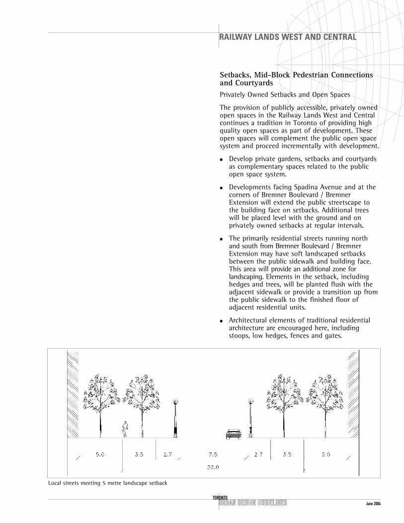
Setbacks, Mid-Block Pedestrian Connectionsand CourtyardsPrivately Owned Setbacks and Open Spaces
The provision of publicly accessible, privately ownedopen spaces in the Railway Lands West and Centralcontinues a tradition in Toronto of providing highquality open spaces as part of development. Theseopen spaces will complement the public open spacesystem and proceed incrementally with development.
� Develop private gardens, setbacks and courtyardsas complementary spaces related to the publicopen space system.
� Developments facing Spadina Avenue and at thecorners of Bremner Boulevard / BremnerExtension will extend the public streetscape tothe building face on setbacks. Additional treeswill be placed level with the ground and onprivately owned setbacks at regular intervals.
� The primarily residential streets running northand south from Bremner Boulevard / BremnerExtension may have soft landscaped setbacksbetween the public sidewalk and building face.This area will provide an additional zone forlandscaping. Elements in the setback, includinghedges and trees, will be planted flush with theadjacent sidewalk or provide a transition up fromthe public sidewalk to the finished floor ofadjacent residential units.
� Architectural elements of traditional residentialarchitecture are encouraged here, includingstoops, low hedges, fences and gates.
Local streets meeting 5 metre landscape setback

URBAN DESIGN GUIDELINESTORONTO
RAILWAY LANDS WEST AND CENTRAL
June 2004
Tree and shrub planting between base buildings and sidewalk
Mid-block Connections
Mid-block pedestrian connections are encourageswithin the development parcels, and are intended tobe designed as pedestrian landscaped mews.
� The design of these spaces will visually andphysically connect Bremner Boulevard / BremnerExtension sidewalks to the linear parks.
� The sidewalks will be flush to and connected tothe public sidewalks to the north and south. Anychanges in grade will be taken up in a mannerthat minimizes stairs and is accessible.
� On Block 20, the east edge will define an openspace. If there are residential units at grade theywill face this open space and have a transitionallandscaped “front yard” zone.
� Mid-block connections will provide pedestrianaccess and an address to individual residentialunits along their frontage.
� Any paved area necessary for service access to theadjacent blocks will be integrated into the largerlandscaped design for the space. The space willcontain elements of the design language of theadjacent public realm such as decorative paving,pedestrian scaled lighting, benches and ifpractical, be accessible to the general public.
Residential Courtyards
Courtyards will be formed by most of the residentialdevelopments. Their principal role will be to providefor an on-site open space amenity for the residentsin the adjacent development. In the context of siteplan review for the first development on a block,applicants will be expected to demonstrate acoordinated design concept which will provideappropriate grading, facilities for pedestriancirculation and landscaping, coordinated servicingand automobile access and connectivity to theadjacent lands to maximize amenity and usefulnessfor pedestrians. To be most effective, the courtyardwill have a unified landscape design with openspace amenity such as gardens and play areas onindividual sites shared with those of the block.
The design of residential courtyards will consider:
� Venting for parking garage below
� Air quality
� Noise quality
Well landscaped residential courtyard at Queen Street andBrooklyn Avenue

� Sun/shade patterns
� Access from units
� Access from street
� Impact of rail corridor (particularly Blocks 21 and 28).
� In addition to the above, courtyards will havelow-level lighting, wheelchair access, solid surfacepathways, benches, garbage receptacles andweather protection. Secured gates will preventthe general public from access, but will bedesigned to be visible and accessible to residents.A view into the courtyards from adjacent streets,parks, walkways and surrounding units allowsinformal surveillance.
� Elevated courtyards will not have any servicefunctions.
� Trees planted on slabs in courtyards will haveappropriate soil cover on top of waterproofing topermit the design intent to be met.
URBAN DESIGN GUIDELINES
RAILWAY LANDS WEST AND CENTRAL
TORONTOJune 2004
Block 36
� A portion of the Block 36 residential courtyardhas been given to the interpretation of themouth of the former Garrison Creek. The on-siteamenity and uses are reduced by the change insize of the courtyard. The amenity and usesassociated with courtyards in the district will berelocated to the roofs of the buildings on thisblock.
� Special care will be taken in designing roof-topamenity space to provide adequate shelter fromprevailing winds with architectural and landscapeelements to promote comfortable use.
Mouth of former Garrison Creek
Block 36

June 2004 URBAN DESIGN GUIDELINESTORONTO
RAILWAY LANDS WEST AND CENTRAL
Public Transit Facilities� TTC stops along Bathurst Street, Spadina Avenue
and Bremner Boulevard / Bremner Extension willbe co-ordinated with building entrances, locationof adjacent weather protection, crosswalks andpedestrian routes through and around adjacentblocks.
Phased Implementation and Long-TermPlanningThe development of the Railway Lands will occurincrementally over a long period of time. It isimportant to consider the following interimmeasures and long-term strategies as these landsdevelop.
Landscaping Undeveloped Blocks
� Undeveloped blocks will have setback areasplanted as part of the public sidewalk area, a fence or barrier at the build-to lines, andhydroseed planting.
� Streetscape paving, planting and lighting willoccur at the time of the road construction.
Dismantling of the Gardiner
� Blocks abutting the Gardiner Expressway will bedesigned to anticipate future dismantling of thestructure with appropriate setbacks, windowtreatment, building access, and openings betweenbuildings.
� The ongoing recommendations of theGardiner–Lakeshore Task Force will be taken intoconsideration for the design of the southern edgeof the Railway Lands West and Central.
� View corridors will be graded to allow for viewsover the Gardiner where possible.
Building over the Rail Corridor
� Initial grading of the lands immediately south of the rail corridor between Dan Leckie Way and Spadina Avenue will not preclude theconstruction of a deck over the rail corridor.Development along the northern linear park will not preclude this possibility.
� All temporary uses and structures on these landswill have regard for these guidelines.
Landscaping of interim at-grade parking
� In order to minimized the visual impact ofparking at-grade within the Railway Lands, allparking will be screened from the street in amanner that contributes to the continuity of thestreet edge and provides for the safety of theparking lot user and the pedestrian on the publicsidewalk.