Stratigraphy, Radiocarbon Dating, and Culture History of Charlie ...
Upload
nguyenquynhCategory
view
216download
1
[RADIOCARBON, VOL. 38, No. 2,19%, P. 277-293]
RADIOCARBON DATING OF SOILS: DATABASE CONTRIBUTION BY BONN AND HAMBURG
H. W. SCHARPENSEEL, FRANZ PIETIG, HEINRICH SCHIFFMAN and PETER BECKER- HEIDMANN
Institut " Bodenkunde, University of Hamburg, Allende-Platz 2, D-20146 Hamburg, Germany
ABSTRACT. We present a compilation of 14C soil dates measured at the University of Hamburg through 1984 (HAM-1597).
INTRODUCTION
The inherent problems in determining the "age of a soil" were described by Scharpenseel and Becker-Heidmann (1992). The dating procedure applied in the production of 14C dates of soil pro- files and samples listed below was described by Scharpenseel, Pietig and Tamers (1968) and Scharpenseel and Pietig (1970). For reasons of brevity, we report only the oldest 14C age of the data set indicated for the layers, thin layers or horizons of the 14C-dated soil profiles. We present an anno- tated bibliography as well as date lists of our work. We also include unpublished soil dates measured in our laboratory, and, following this contribution, Peter Becker-Heidmann reports continuing dates from HAM-1600 onward.
DATE LISTS IN RADIOCARBON: BONN I-VII AND HAMBURG I-IVY
Material dated Lab code(s) Age (yr BP)
University of Bonn, Natural Radiocarbon Measurements I (Scharpenseel, Pietig and Tamers 1968)
Soil and Soil Profile Dates
Germany Hapludoll, Sollingen A B 26-31 4800 100 Hapludoll, Sollingen B B 33-40 s 4060 80 Hapludoll, Sollingen C B 98-104 s 5300 80 Hapludoll, Sollingen D B 106-113 s 5550 80 Haplaquoll, Hildesheim A B 114-120 s 3130 70 Haplaquoll, Hildesheim A B 121-128 s 4000 80 Fossil Chernozem below Hapludalf, Soest II B 3 4000 80 Fossil Chernozem below Hapludalf, Soest I B 4 4170 80 Fossil Chernozem in dark-brown steppe soil, Wallertheim B 22 2560 60 Buried Eutrochrept below AllerOd trachyt blanket B 96 9130 100 Udoll, Ostholsteen A, Grossenbrode B 156 s 1850 70 Udoll, Ostholsteen B, Grossenbrode B 161-165 s 1390 70 Plaggept, Greven (Albachtenesch, Marktesch, etc.) B 9-13 s 1300 80 Plaggept, Greven, Albachtenesch, whole profile B 43-48 s 1220 80 Plaggept, Rheine B 49-54 s 1260 60 Plaggept, Lengerich B 129-135 s 1190 70
(B 135, 80 cm deep 3960 ± 80) Spodosol, Sennesand B 14 930 80 Spodosol, Irrel B19 810 50 Spodosols, Darlaten A and B B 20, 21 s 1220 60
*From 1968-1974 our laboratory was located in Bonn, and our laboratory code designation, as reported inRadiocarbon, was BONN. In 1976, our laboratory numbers changed to HAM- to reflect our relocation to Hamburg. (Lab codes in this table are abbreviated to "B" and "H".) This compilation of our work represents 27 years of soil dating from all over the world.
277
https://doi.org/10.1017/S0033822200017653Downloaded from https://www.cambridge.org/core. IP address: 54.39.17.49, on 10 Apr 2018 at 11:17:13, subject to the Cambridge Core terms of use, available at https://www.cambridge.org/core/terms.

278 H. W. Scharpenseet et al.
Material dated Lab code(s) Age (yr BP)
Spodosols, Scherpenseel A and B B 90, 91 s 2960 t 70
Spodosol, Wilsede B 41 1140 ± 60
Spodosol, Obrehaverbeck B 42 940 ± 50
Spodosols, Flaesheim B 15-17 s 2420 ±80 Hapludalf, Frimmersdorf B 92-95 s 1880 ±80 Half bog soils, Fibrist, Kalkarer Moor I B 82-85 s 7790 ± 110
Half bog soils, Fibrist, Kalkarer Moor II B 8639 s 3160 t 50
University of Bonn, Natural Radiocarbon Measurements II (Scharpenseel, Pietig and Tamers 1969)
Germany Rendolls
Tangelrendsina, Kramer (German Alps) 318-322 4180 ± 70
Moderrendsina Krottenkopf (German Alps) B 324 600 ± 50
Udalfs, argillic horizon probably former A horizon of Mollisol: Parabrown earth, Eltville B 326-331 4940± 80
Parabrown earth, Inden B 334342 s 4170 ± 70
Brown earth, Haaren-Sintfeld B 355-358 s 1580 ± 50
Parachernozem, Fellbach B 372-379 s 2730 ± 70
Parachernozem, Fellbach, brickpit B 380384 s 4150 ± 50
Plaggepts: Southeast of Rietberg B 343-345 1200 ± 70 Brede near Rietberg B 348 720 ± 70
Hoffeld B349-350 s 1130 ± 70
Sinnesche Brede B 351 1540 ± 60
Am Hohen Lande B352 810 ± 70 Krax bei Neuenkirchen B 353 900 ± 60
Modern bomb-carbon samples BONN 172-200 and BONN 303-317 (bomb C curve on cereals, beets, winter rape, wine, 1956-1967)
University of Bonn, Natural Radiocarbon Measurements III (Scharpenseel and Pietig 1970)
Udolls, Vertisols, Fossil A-horizon of Paleosol-Mollisol in Argillic Horizon of Hapludalf
Germany Parabrown earth Lantershofen B 403-409 5530 90 Ochtendung (below trachytic pumice) B 411-416 s 10,580 100
Muddersheim, Thineland B 417-421 s 3700 60 Quarry "Schaferkalkwerke" B 422-431 s 25,000 700 Buried soil organic matter (SOM), Eddersheim B 448 8300 120 Humus containing sand with charcoal (fireplace), Amalienhof B 608a 2530 70 Buried humus, Heiligensee Forest, Berlin B 609 760 60 Bone collagen in paleosol below trachytic tuff, Michelsberg B 763 10,800 100
Bohemia, Czech Republic Argiudoll, Kozojedy, Jicin District B 437-440 4150 90 Agiudoll, Smince, Uradec, Kralove District B 441 4020 60
Hapludoll, Brazdim, Prahoviphod, Tilery District B 442-444 s 3430 65 Vertisol (Smonitza), Prunevor, Choumtov District B 445-447 s 6370 65 Hapludoll, Chernozem, Zozelice, Koniggratz District B 485-487 s 1460 110
Aquoll, Zozelice II, Koniggratz District B 488-490 s 1950 70
Moravia, Czech Republic Argiudoll, Brnicko, Olmutz District B 491, 495 4055 Udoll, sandy loess, Moravia B 496-499 s 3610 75 Udoll, Chernozem, Bilorice B 500, 600-603 s 2450 70 Vertic Udoll (Vertisol-like Chernozem), Tegel, Pole, Brunn B 604-607 s 4070 70
https://doi.org/10.1017/S0033822200017653Downloaded from https://www.cambridge.org/core. IP address: 54.39.17.49, on 10 Apr 2018 at 11:17:13, subject to the Cambridge Core terms of use, available at https://www.cambridge.org/core/terms.

Bonn-Hamburg 14C Dating of Soils 279
Material dated Lab code(s) Age (yr BP) Russia
Hapludoll, Vermudoll, Chernozem, Orel B 455-457 s 4720 ± 60 Udoll, Chernozem, Charkov B 460-462 s 5920 ± 140 Udoll, Chernozem, Zaparoskje B 464-466 s 3270 ± 80 Udoll, Chestnut soil, Askania Nova B 468-470 s 2710 ± 80 Tunisia Vertisol, Beja (deepest humus layer) B 433 40 Vertisol, Zouarme, Ebba Ksour B 434 3680 ± 65 Finland Sandy humus 75 cm deep, Kevo, North Finlandia B 449 70 Spitzbergen
Fossil A horizon, 55 cm deep, Hohenstaufen Plateau, Barents I B 432 80 Germany SOM fractions Chernozem, Sollingen, total organic matter 6A 80 Chernozem, Sollingen, humic acid extract only B 6B 2240 ± 80 Spodosol, Scherpenseel, brown humic acid fraction B 138 2060 ± 60 Spodosol, Scherpenseel, gray humic acid fraction B 139 1720 ± 60 Spodosol, Scherpenseel, rim of gravel pit B 366 2930 ± 40 Spodosol, Scherpenseel, hymatomelanic acid fraction B 367 1580 ± 80 Spodosol, Scherpenseel, brown humic acid fraction B 368 2530 ± 60 Spodosol, Scherpenseel, gray humic acid fraction B 369 2980 ± 70 Spodosol, Scherpenseel, humin fraction B 370 2850 ± 70 Histosol, Kalkarer Moor, fulvic acid fraction B 360 4270 ± 80 Histosol, Kalkarer Moor, hymatomelanic acid fraction B 361 4510 ± 80 Histosol, Kalkarer Moor, brown humic acid fraction B 362 5380 ± 80 Histosol, Kalkarer Moor, gray humic acid fraction B 363 5970 ± 40 Histosol, Kalkarer Moor, humin fraction B 364 3490 ± 70 Histosol, Kalkarer Moor, humus coal fraction B 365 4460 ± 80 Aquoll, pseudogley-Chernozem, Adlum, fulvic acid fraction B 397 1800 ± 60 Aquoll, pseudogley-Chernozem, hymatomelanic acid fraction B 398 1390 ± 70 Aquoll, pseudogley-Chernozem, brown and gray humic acid fraction B 399 4890 ± 50 Aquoll, pseudogley-Chernozem, humin fraction B 401 2980 ± 70 Aquoll, pseudogley-Chernozem, humus coal fraction B 402 2810 ± 60
University of Bonn, Natural Radiocarbon Measurements IV (Scharpenseel and Pietig 1971) Soil Profiles
Hun gary Udalf, Chernozem, Erd, southeast Budapest B 611-615 9680± 100 Udalf, Chernozem in sand-loess, Balatonfoldvar, south bank of Lake B 625-627 s 4690 60
Balaton Udalf, Chernozem in fine sandy loess, Koszarhegy B 633-636 4575 60 Udalf, meadow soil, Boconad, east-northeast Budapest B 616-620 s 5260 50 Eutrochrept, Brown earth in loess, Kapoly B 628-632 s 3990 70 Hapludalf, Nagyresce, southeast Budapest B 621-624 s 2870 115
(below 112 cm, 14C age jumps to 16,750 ± 290) Natrustalf, Hortobagy, southwest Debrecen, Rusta Plain B 648-651 10,080 160 Histosol, bog soil, Nadasdladany, northeast of Lake Balaton B 637-647 s 9300 340 Russia Udoll, deep Chernozem, Orel (240 cm) B 458 360
https://doi.org/10.1017/S0033822200017653Downloaded from https://www.cambridge.org/core. IP address: 54.39.17.49, on 10 Apr 2018 at 11:17:13, subject to the Cambridge Core terms of use, available at https://www.cambridge.org/core/terms.
280 H. W. Scharpenseel et al.
Material dated Lab code(s) Age (yr BP)
Ireland Plaggept, Donoure, Ardfield B 660 50
Plaggept, Cahesetrant, Dingle B 661-663 s 2135 ±50
Australia Ustoll, Krasnozem, Wollongbar B 664 60
Ustoll, Krasnozem, Babbinbar B 679-680, 766 s 6010 100
Ustoll, Krasnozem, Beechmont B 681, 767 s 3850 360
Krasnozem, Binjour on lateritic plateau B 682 and 768 s 1780 70
Krasnozem, Gurgena on lateritic plateau B 683 and 769 s 570 70
Krasnozem, Coulston Lakes I, valley plain B 684 and 770 s 950 50
Krasnozem, Coulston Lakes II, valley plain B 685 and 771 s 980 50
Krasnozem, Maleny, dissected plateau, 15 cm B 685 150 50
Krasnozem, Memerambi, dissected plateau B 687 and 772 4000 150
Argentina Vertisol, Entre Rios, ConcepciGn del Uruguay B 804-813 11,160 150
Germany Humod, Hauset/Hergenrath B 652-656 2240 50
Placorthod, Schliffkopfhaus B 859-861 s 2280 60
Andosol, Brown earth in trachytic ash, 200 m south of Andernach- B 818-822 s 4470 70
Kruft road Andosol, Brown earth in trachytic ash, Neuwied basin B 823-828 4210 80 Inceptisol, Brown earth in trachytic ash, Niedermendig B 829 3990 100
Mardelle with peat-carbon, Pirmasens B 1132 900 60
Czech Republic Udalf, Chernozem (buried), Sedlec B 843-845 12,480 120
Udalf, Chernozem (not buried), Sedlec B 843-845 s 5910 60
Udalf, Chernozem (buried) underlying Holocene Chernozem B 847 25,730 550
Udalf, Chernozem, Chabry (Holocene) B 848-849 s 5810 60 Udalf, Chernozem, Chabry (Pleistocene) B 850-853 s 17,520 540
Udalf, Chernozem, Chabry (some locations, deepest point) B 854 25,630 710
Italy Fossil steppe soil, buried, Vintschgau, Bolzano B 864 60
SOM Fractions
Germany Udoll, Chernozem, Sollingen, fulvic acids B 670 0.5 pMC Same soil, brown- and gray humic acids B 671 1560 ± 70
Same soil, humin and humus coal B 672 2275 ±60 Michelsberg, fulvic acids B 673 4310 ± 210 Same soil, brown and gray humic acids B 674 7600 ± 220
Same soil, humins B 675 6930 ± 80 Same soil, humus coal B 676 6830 ± 100
SOM of Udalf, Chernozem, Sollingen, different centrifugal gravity 500 rpm B 831 50 2000 rpm B832 1870 ± 70
3000 rpm B833 1680± 50 4000 rpm B 834 1820 ± 100 5000 rpm B835 1770± 60
5400 rpm B836 1780 ± 50
https://doi.org/10.1017/S0033822200017653Downloaded from https://www.cambridge.org/core. IP address: 54.39.17.49, on 10 Apr 2018 at 11:17:13, subject to the Cambridge Core terms of use, available at https://www.cambridge.org/core/terms.
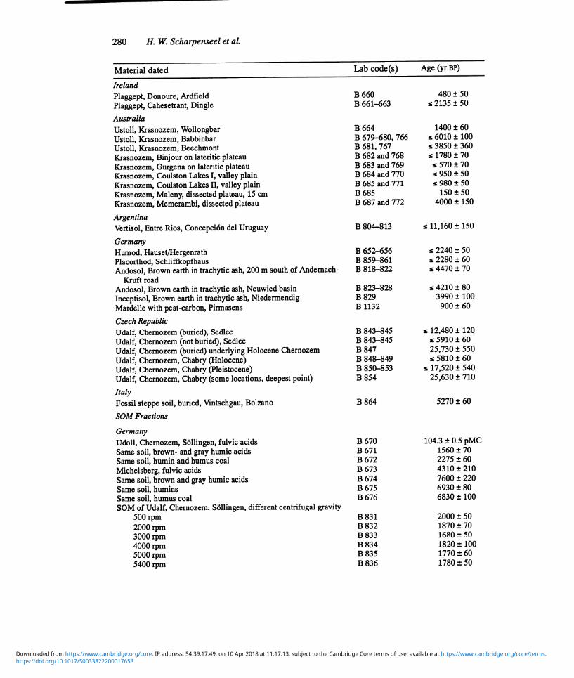
Bonn-Hamburg 14C Dating of Soils 281
Material dated Lab code(s) Age (yr BP)
Hapludalf, Inden, fossil A horizon in B, (argillic horizon), varying texture fractions
>60 µ O B 1133 3170 ± 80 60-21u B 1134 3450 ± 80 2-1k B 1135 3280 ± 80 1-0.5k B 1136 2790± 770 0.5-0.25,u B 1137 2500 ± 70
Subhydrous Soils, Gyttja Germany Schalkenmeerer Maar, 0-230 cm B 781-802 s 4600 ± 70 Lake of Selent, gyttja, 0-560 cm B 882-908 s 6800 ± 150
University of Bonn, Natural Radiocarbon Measurements V (Scharpenseel and Pietig 1973a) Soil Profiles
Israel Xeralf, Hamra, below dune cover, Tel Aviv-Haifa highway, corner of B 688-691 s 14,740 ± 200
Richlon Street Xeralf, same location, foot of slope, no continuous dune cover B 692-695 s 10,470 ± 130 Xeralf, same location, emerging into recent soil, no dune cover B 696-699 s 11,860 ± 150 Xeralf, Hamra, in dune material with lime concretions (Curcar), Win- B 701-706 s 17,920 ± 180
gate Institute of Athletics, near Tel Aviv-Haifa highway Xeralf, calcinated root in Hamra, street to Ecron B 709 16,930 ± 240 Curcar-Hamra sequence, Rehovot, corner of Main Street and Batia B 711 14,920 ± 230
Markov Aqualf, Nazas, Jashresh B 712, 713 s 2960 ± 220 SoilAssocations on Limestone Xeroll on soft limestone, Mitzpe Mesua B 742, 743 s 1500 ± 50 Xerochrept, calcareous brown earth on harder limestone, near Mitzpe B 744 2040 ± 60
Mesua Rhodustalf-Terra Rossa on hard limestone, Mattah B 745 2420 ± 70 Xeralft with recalcification (Husmas soil), Agricultural School, B 748, 749 s 5050 ± 160
Kanot Xeroll, Burozem, overlying Xeralf with recalcification (Husmas),
Kibbutz Ruchama Xeroll B 751, 752 s 9000 ± 200 Underlying recalcified Xeralf B 753-755 s 13,400 ± 190 Fossil clay below recalcifted Xeralf B 757 19,920 ± 340
Dark brown soil in calcareous dune sand, chesnut-like soil, Mafkiim, B 750 4760 ± 80 south of Ashkalon
Palexeroll near Shuval, road from Beer Shewa to Tel Aviv B 760-762 s 15,470 ± 230 Paleorthid in loess, Eshel Hanassi, neer Beer Sheva B 758-759 s 4020 ± 220 Xerert, west Plain of Barkai, road from Afula to Hedra B 715-718 s 1850 ± 70 Xerert, Valley of Jesrael B 719-723 s 2760± 80 Xerert, Valley of Jesrael, drainage ditch B 724-728 s 7440 ± 80 Xerert, El Hamma B 729-734 s 19,430 ± 350 Xerert, near Kefar Manachem Kibbutz B 735-741 s 16,100 ± 270 Xerert along Syrian Quarantine Station and Jordan flow into Lake B 773-776 s 2670 ± 100
Genezareth
Bulgaria Vertic Albaqualf, Glavatsi B 1071-1074 s 8050 ± 80 Udic Haplustoll, leached Chernozem, near Gorni Dubnik B 1075-1079 s 11,100 ± 90
https://doi.org/10.1017/S0033822200017653Downloaded from https://www.cambridge.org/core. IP address: 54.39.17.49, on 10 Apr 2018 at 11:17:13, subject to the Cambridge Core terms of use, available at https://www.cambridge.org/core/terms.

282 H. W. Scharpenseel et al.
Material dated Lab Code(s) Age (yr BP)
Typic Caciustoll, calcareous Chernozem, northwest Pleven B 1080-1085 Paleustalf, Gray Forest soil, 12 km south of Pleven B 1086-1092 Udic Haplustalf, Gray Forest soil, Kozlevo-Shoumen B 1093-1097 Udertic Paleustalf, degraded Cinnamon Forest soil, near Bourgas B 1098-1104 Vertic Albaqualf, Cinnamonic, podzolized Planosol, Badeshte, Thra-
cian plain B 1105-1108
Pellustert, Smonitsa-Vertisol, Sredets, Thracian Plain B 1108-1114 Chromic Luvisol, Cinnamonic Forest soil, Koren
Sardinia
B 1115-1119
Xerert (aquic), Plane de Cuga, Ittiri, southwest Sassari B 1154-1157 Chromoxerert, river terrace, Rio Mannu di S. Vero B 1141-1164 Pelloxerert, Arziadas, Tuvoi B 1167-1174 Chromoxerert, Monastir, 20 km north of Cagliari B 1175-1178 Pellustert, Nurallo
Sicily
B 1180-1187
Chromoxerert, Scalilli near Corleone B 1326-1331 Pelloxerert, Plana di Scala, Corleone B 1332-1338 Pelloxerert, Aziena Sporacia, Farm, University di Palermo B 1339-1351 Pelloxerert, Aziena Sporacia, Farm, University di Palermo
Romania
B 1352-1363
Humic horizon underlying Danube alluvium, near Bucharest
Germany
B 1379-1385
Aqualfic Fragiorthod, Amelsburen B 1363-1369 (below 160 cm, 15,170 ± 230)
Placorthod Grindenschwarzwald Gemsbach B 1371-1377
s 5760 ± 90 s 18,920 ± 340
s 3370 ± 100 s 14,150 ± 240
s 9850 ± 240
s 16,140 ± 460 s 8480 ± 140
s 570 ± 50 s 3870 ± 130
5430 ± 100 s 2270 ± 70 s 3220 # 80
s 3030 ± 90 s 3670 ± 100 s 5470 ± 120
s 15,160 ± 370
s 8070 ± 130
s 1980 ± 80
s 2550 ± 70
University of Bonn, Natural Radiocarbon Measurements VI (Scharpenseel and Pietig 1973b)
Soil Profiles
Spain Xerert, La Rinconada (Seville), Casas vacas 1388-1392 6470 130 Xerert, Carmona, km 10.5 Carmona-Arahal Street B 1393-1397 s 6650 120 Xerert, Los Palacios, Torbiscal Farm B 1398-1406 s 8850 130 Xerert, El Arahal, Estrella Farm, 40 km east of Seville B 1407-1413 s 3480 100 Xerert, Carmona, La Motilla Chica Farm B 1417-1423 s 3440 290
Portugal Xerert, Black Barros, Beja B 1425-1432 3070 140 Vertic Xerochrept, Safara-Camauros Farm B 1433-1437 s 2430 70 Xerert, Safara field B 1438-1442 s 2230 190 Red Xerert, Salvada-Bej a B 1443-1446 s 1380 70 Roman grain silo in Xerert, Beja-Serpa B 1447 5150 100 Dark red Xerert, Montes Velhos Aljustrel B 1452-1457 s 2240 80 Red-brown Xerert, Terra Grande de Lisboa, Tapaiao da Ajuda, uni- B 1458-1463 s 3170 80
versity campus near Lisbon
Australia Ustert, Lillimur, Kaniva District, Victoria, Gilgai mound 1466-1485 5880 180 Ustert, Lillimur, Kaniva District, Victoria, Gilgai depression B 1486-1507 s 2280 150 Ustert, Miram, Kaniva District, Victoria, Gilgai mound B 1508-1527 s 8530 250 Ustert, Miram, Kaniva District, Victoria, Gilgai depression B 1528-1548 s 8450 260
https://doi.org/10.1017/S0033822200017653Downloaded from https://www.cambridge.org/core. IP address: 54.39.17.49, on 10 Apr 2018 at 11:17:13, subject to the Cambridge Core terms of use, available at https://www.cambridge.org/core/terms.
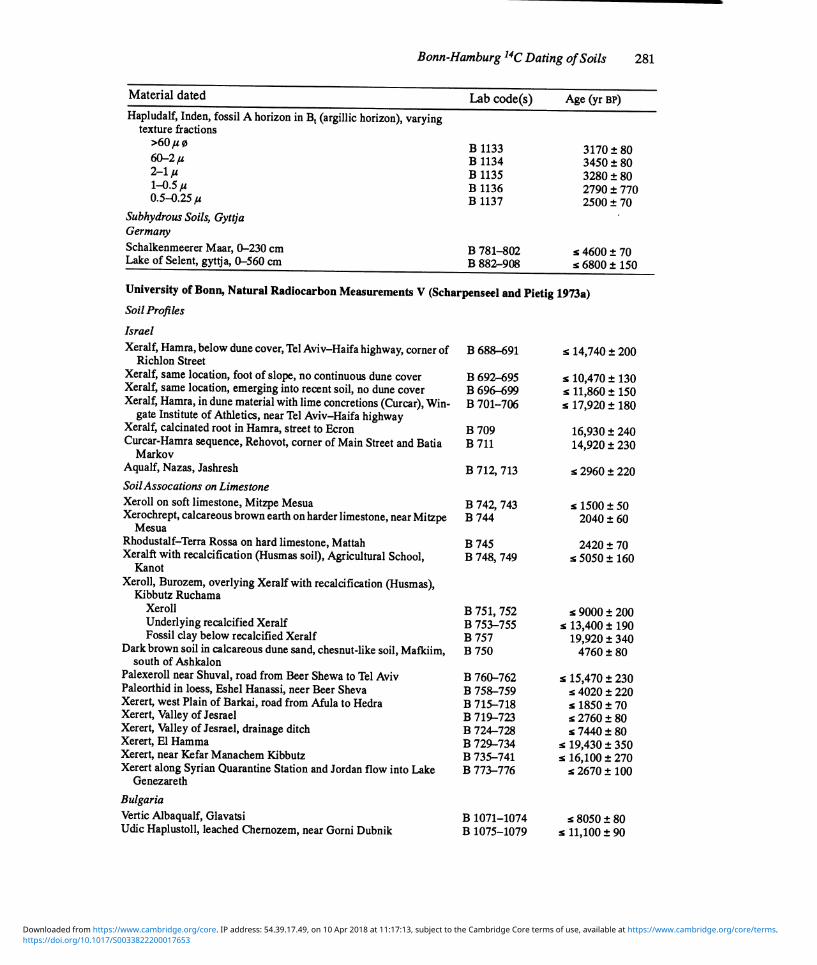
Bonn-Hamburg 14C Dating of Soils 283
Material dated Lab code(s) Age (yr BP)
Germany Fossil A horizon, Eberspoint,10 km west of Freising B 1464 90 Fossil A horizon, terrace brown earth, 5 km south of Siegenburg, B 1648 2270 70
Abens Valley, north Bavaria Charcoal from different fireplaces B 1648,1649 1460 70 Hapludalf in flood loam, lower terrace of the Rhine River B 1652 5080 110 Fossil A horizon below Hapludalf, same location B 1653 8230 470 Bituminous coating on gravel in younger Isar terrace, Ascholding, B 1657 28,320 470
Wolfratshausen Basin Umbrept (Plaggept?), Wurmian basal moraine of Isar foreland gla- B 1669-1672 3800 80
cier, Unterbuchen, Bavaria Root in Maintag gravel pit, Upper Franconia B 1700 70 Fossil A horizon in Maintag gravel pit, Upper Franconia B 1801 7980 110 Root, vertical in sediment, Maintag gravel pit B 1802 4360 90 Fossil A horizon, covered by Pleistocene terrace material, Karlich, B 1659 30,450 1270
Rhineland Humus in silty A horizon, below tuffaceous material, north slope of B 1699 510
Bausenberg, Lengsdorf, Rhineland Fossil A horizon, gravelly gley, Gammelsbach valley, North Eber- B 1815 110
bach, Odenwald
Soil Fractions Fossil A horizon, underlying Allerod trachytic tuff, charcoal only B 1681 160 Same location, particle size fraction > 0.2 mm B 1681 7570 ± 190 Same location, particle size fraction 63-2,u B 1684 10,950 ± 150 SOM from continuous extraction, successive fractions (1st extrac-
tion: 0.1N H2SO4, 2nd extraction: 0.15 M Na4P2O ) 7 Udalf Aseler Holz:
B 1809 100 B 1810 4130 ± 270 B 1811 4970 ± 80
Spodosol (Humod) gravel pit Weber Scherpenseel (Dutch border): ,
B 1688 1400± 140 B 1689 1160 ± 70 B 1691 1460 ± 80 B 1692 1350± 110 B 1693 1510± 130
Humod, Scherpenseel, Weber gravel pit B 1697 1290 ± 70 Subhydrous Soils Gyttja, bottom of Schalkenmehrer Maar, Eifel I B 994-1005 s 12,130 ± 140 Gyttja, bottom of Schalkenmehrer Maar, Eifel II B 1007-1025 s 12,160 ± 130 Gyttja, bottom of Schalkenmehrer Maar, Eifel IV B 1026-1045 s 12,130 ± 140 Gyttja, bottom of Schalkenmehrer Maar, Eifel V B 1046-1064 s 3840 ± 80 Gyttj a, bottom of Lake of Selent, Holsteen I B 869-880, s 1670 ± 100
1122-1125 2 m below end of case lot (sampling instrument) 10,170 ± 140
Gyttj a, bottom of Lake of Selent, Holsteen III B 911-932, s 24,830 ± 970 963 964
Gyttja, bottom of Lake of Selent, Holsteen IV -
B 933-959 17,390 ± 460 On-shore profile, Lake of Selent, Holsteen IV (opposite Profile IV) B 1127-1131 s 2670 ± 70 Gyttj a, bottom of Lake of Selent, Holsteen V B 967-976 s 14,180 ± 670 Gyttj a, bottom of Lake of Selent, Holsteen VI B 977-993 s 10,080 ± 520 at 340 cm depth 30,930 ± 1150
https://doi.org/10.1017/S0033822200017653Downloaded from https://www.cambridge.org/core. IP address: 54.39.17.49, on 10 Apr 2018 at 11:17:13, subject to the Cambridge Core terms of use, available at https://www.cambridge.org/core/terms.
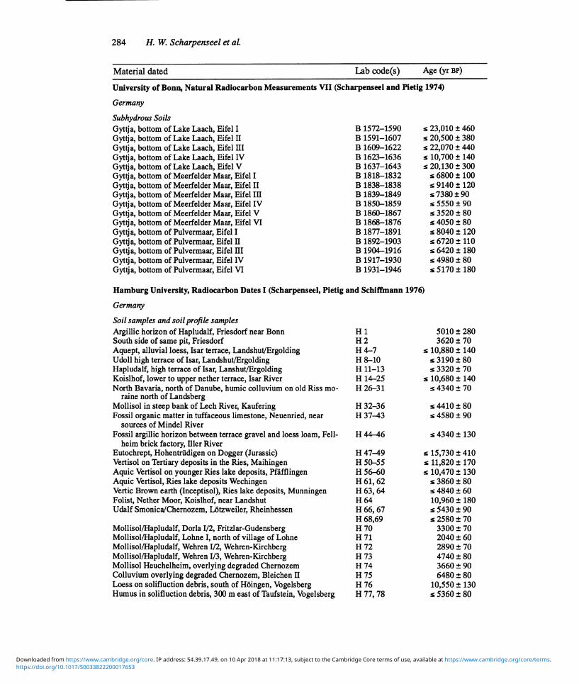
284 H. W. Scharpenseel et al.
Material dated Lab code(s) Age (yr BP)
University of Bonn, Natural Radiocarbon Measurements VII (Scharpenseel and Pietig 1974)
Germany
Subhydrous Soils Gyttja, bottom of Lake Laach, Eifel I 1572-1590 23,010 ± 460 Gyttja, bottom of Lake Laach, Eifel II B 1591-1607 s 20,500 ± 380 Gyttj a, bottom of Lake Laach, Eifel III B 1609-1622 s 22,070 ± 440 Gyttj a, bottom of Lake Laach, Eifel IV B 1623-1636 s 10,700 ± 140 Gyttja, bottom of Lake Laach, Eifel V B 1637-1643 s 20,130 ± 300 Gyttja, bottom of Meerfelder Maar, Eifel I B 1818-1832 s 6800± 100 Gyttja, bottom of Meerfelder Maar, Eifel II B 1838-1838 s 9140± 120 Gyttja, bottom of Meerfelder Maar, Eifel III B 1839-1849 s7380±90 Gyttja, bottom of Meerfelder Maar, Eifel IV B 1850-1859 s 5550 ± 90 Gyttja, bottom of Meerfelder Maar, Eifel V B 1860-1867 s 3520 ± 80 Gyttja, bottom of Meerfelder Maar, Eifel VI B 1868-1876 s 4050± 80 Gyttja, bottom of Pulvermaar, Eifel I B 1877-1891 s 8040± 120 Gyttj a, bottom of Pulvermaar, Eifel II B 1892-1903 s 6720± 110 Gyttja, bottom of Pulvermaar, Eifel III B 1904-1916 s 6420± 180 Gyttja, bottom of Pulvermaar, Eifel IV B 1917-1930 s 4980 ± 80 Gyttja, bottom of Pulvermaar, Eifel VI B 1931-1946 s 5170± 180
Hamburg University, Radiocarbon Dates I (Scharpenseel, Pietig and Schiffmann 1976)
Germany
Soil samples and soil profile samples Argillic horizon of Hapludalf, Friesdorf near Bonn Hi 280 South side of same pit, Friesdorf H2 3620 ± 70 Aquept, alluvial loess, Isar terrace, Landshut/Ergolding H4-7 s 10,880 ± 140 Udoll high terrace of Isar, Landshut/Ergolding H8-i0 s 3i90±80 Hapludalf, high terrace of Isar, Lanshut/Ergolding H 11-13 s 3320 ± 70 Koislhof, lower to upper nether terrace, Isar River H i4-25 s 10,680 ± 140 North Bavaria, north of Danube, humic colluvium on old Riss mo- H26-3i s 4340 ± 70
raine north of Landsberg Mollisol in steep bank of Lech River, Kaufering H3236 Fossil organic matter in tuffaceous limestone, Neuenried, near H 37-43 s 4580 ± 90
sources of Mindel River Fossil argillic horizon between terrace gravel and loess loam, Fell- H44-46 4340± 130
heim brick factory, lller River Eutochrept, Hohentrudigen on Dogger (Jurassic) H 47-49 15,730 ± 410 Vertisol on Tertiary deposits in the Ries, Maihingen H 50-55 s 11,820 ± 170 Aquic Vertisol on younger Ries lake deposits, Pfafflingen H 56-60 s 10,470±130 Aquic Vertisol, Ries lake deposits Wechingen H 61, 62 s 3860 ± 80 Vertic Brown earth (Inceptisol), Ries lake deposits, Munningen H 63, 64 s 4840 ± 60 Folist, Nether Moor, Koislhof, near Landshut H 64 10,960 ± 180 Udalf Smonica/Chernozem, Lotzweiler, Rheinhessen H 66, 67 s5430±90
H 68,69 s 2580 ± 70 Mollisol/Hapludalf, Dorla I/2, Fritzlar-Gudensberg H 70 3300 ± 70 Mollisol/Hapludalf, Lohne I, north of village of Lohne H 71 2040 ± 60 Mollisol/Hapludalf, Wehren I/2, Wehren-Kirchberg H 72 2890 ± 70 Mollisol/Hapludalf, Wehren I/3, Wehren-Kirchberg H 73 4740 ± 80 Mollisol Heuchelheim, overlying degraded Chernozem H 74 3660 ± 90 Colluvium overlying degraded Chernozem, Bleichen II H 75 6480 ± 80 Loess on solifluction debris, south of Hoingen, Vogelsberg H 76 10,550 ± 130 Humus in solifluction debris, 300 m east of Taufstein, Vogelsberg H 77, 78 s 5360 ± 80
https://doi.org/10.1017/S0033822200017653Downloaded from https://www.cambridge.org/core. IP address: 54.39.17.49, on 10 Apr 2018 at 11:17:13, subject to the Cambridge Core terms of use, available at https://www.cambridge.org/core/terms.
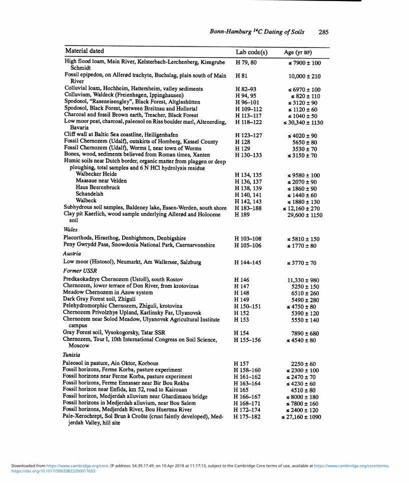
Bonn-Hamburg 14C Dating of Soils 285
Material dated Lab code(s) Age (yr BP)
High flood loam, Main River, Kelsterbach-Lerchenberg, Kiesgrube Schmidt
H 79, 80 7900 100
Fossil epipedon, on Allerod trachyte, Buchslag, plain south of Main River
H 81 210
Colluvial loam, Hochheim, Hattersheim, valley sediments H 82-93 s 6970 100 Colluvium, Waldeck (Freienhagen, Ippinghausen) H 94, 95 s 820 110 Spodosol, "Raseneisengley", Black Forest, Altglashutten H 96-101 s 3120 90 Spodosol, Black Forest, between Breitnau and Hollertal H 109-112 s 1120 60 Charcoal and fossil Brown earth, Trescher, Black Forest H 113-117 s 1040 50 Low moor peat, charcoal, paleosol on Riss boulder marl, Altenerding,
Bavaria H 118-122 30,340 1130
Cliff wall at Baltic Sea coastline, Heiligenhafen H 123-127 s 4020 90 Fossil Chernozem (Udalf), outskirts of Homberg, Kassel County H 128 5650 80 Fossil Chernozem (Udalf), Worms I, near town of Worms H 129 3530 70 Bones, wood, sediments believed from Roman times, Xanten Humic soils near Dutch border, organic matter from plaggen or deep
ploughing, total samples and 6 N HCl hydrolysis residue
130-133 3150 70
Walbecker Heide H 134,135 s 9580 100 Maasaue near Velden H 136,137 s 2070 90 Haus Beerenbruck H 138,139 s 1860 90 Schandelah H 140,141 s 1440 60 Walbeck H 142,143 s 1880 130
Subhydrous soil samples, Baldeney lake, Essen-Werden, south shore H 183-188 s 12,160 270 Clay pit Kaerlich, wood sample underlying Allerod and Holocene
soil
Wales
189 1150
Placorthods, Hiraethog, Denbighmors, Denbigshire H 103-108 s 5810 150 Peny Gwrydd Pass, Snowdonia National Park, Caernarvonshire
Austria H 105-106 1770 80
Low moor (Histosol), Neumarkt, Am Wallersee, Salzburg
Former USSR
H 144-145 3770 70
Predkaokadzye Chernozem (Ustoll), south Rostov H 146 11,330 ± 980 Chernozem, lower terrace of Don River, from krotovinas H 147 5250 ± 150 Meadow Chernozem in Azow system H 148 6510 ± 260 Dark Gray Forest soil, Zhiguli H 149 5490 ± 280 Pelehydromorphic Chernozem, Zhiguli, krotovina H 150-151 s 4750 ± 80 Chernozem Privolzhye Upland, Karlinsky Far, Ulyanovsk H 152 5390 ± 120 Chernozem near Solod Meadow, Ulyanovsk Agricultural Institute
campus H 153 140
Gray Forest soil, Vysokogorsky, Tatar SSR H 154 7890 ± 680 Chernozem, Tour I, 10th International Congress on Soil Science,
Moscow
Tunisia
155-156 4540 ± 80
Paleosol in pasture, Ain Oktor, Korbous H 157 2250 ± 60 Fossil horizons, Ferme Korba, pasture experiment H 158-160 s 2300± 100 Fossil horizons near Ferme Korba, pasture experiment H 161-162 s 2470 ± 70 Fossil horizons, Ferme Ennasser near Bir Bou Rekba H 163-164 s 4230 ± 60 Fossil horizon near Enflda, km 52, road to Kairouan H 165 4510 ± 80 Fossil horizon, Medjerdah alluvium near Ghardimaou bridge H 166-167 s 8000 ± 180 Fossil horizons in Medjerdah alluvium, near Bou Salem H 168-171 s 7800 ± 160 Fossil horizons, Medjerdah River, Bou Huertma River H 172-174 s 2400 ± 120 Pale-Xerochrept, So! Brun a Croflte (crust faintly developed), Med-
jerdah Valley, hill site H 175-182 27,160 ± 1090
https://doi.org/10.1017/S0033822200017653Downloaded from https://www.cambridge.org/core. IP address: 54.39.17.49, on 10 Apr 2018 at 11:17:13, subject to the Cambridge Core terms of use, available at https://www.cambridge.org/core/terms.

286 H. W. Scharpenseel et aL
Material dated Lab code(s) Age (yr BP)
Hamburg University, Radiocarbon Dates II (Scharpenseel and Schiffmann 1977)
Argentina Argiudoll, Brunizem, Rafaela Argiudoll, Brunizem, Esperanza Argiudoll, slightly planosolic Brunizem, Angel Gallardo Arguidoll, Profile B9, Villa Concepcibn del Tio
Tunisia Paleosol in Bou Huertma alluvium
Germany Mud in old river bed of Ems River, on top of low moor, Rietberg Ochrept, Holzkirchen, near Munich-Salzburg highway Humic acid samples of Lower Saxonian soils SOM fractions, Spodosol, Scherpenseel, near Dutch border SOM fractions, Udoll, Aseler Wald, near Hildesheim SOM fraction, paleosol of loess, below trachytic tuff of Allerod vol-
canism SOM fractions, vertic, clayey Histosol, Koislhof, lower terrace of Isar
River SOM fractions after repeated 6 HC1 hydrolysis, Udoll from Asel clay
pit near Hildesheim SOM fractions after repeated 6 HCl hydrolysis, histic Udoll, Ergold-
ing near Landshut Sea level-coast line study based on peat dating, North Sea shore Humus in Elbe River alluvium, Billwerder-Allermohe, south Ham-
burg, measurement of deposition date
H 238-244
H 246-252 H 253-257
H 258-259
H 280-281 H 631-634 H 260-279 H 282-285 H 286-297 H 298-310
H 311-328
H 623-630,
H 762-788,
H 765-776 H 791-799
1
s 2030
s 2780 s 1870
s 4930
s 6680 s 2510
s 19,800 s 5410 s 3160
s 11,360
s 13,140
s 3260
s 6110
s 6130 s 3370
± 80 ± 80 ±
90
± 80
± 90 ± 50 ± 710 ± 90 ± 70 ± 150
± 200
± 100
± 90
± 240 ± 100
Hamburg University, Radiocarbon Dates III (Scharpenseel, Schiffmann and Hintze 1984)
Germany Histic Hapludoll, 5 km south of Sollingen, 0-90 cm, at 5-cm intervals
Carbonate-free soil 2255-2272 s 6210 90 6 N HCl hydrolysis residue B 2401--433 s 6370 ± 80 6N HCl hydrolyzate B 2400-2428 s 3240 ± 70 Acid from carbonate destruction B 2438-2450 s 3570 ± 70
Typic Hapludoll, Sollingen, near old windmill, 0-75 cm, at 5-cm in- B 2275-2289 s 2450 ± 60 tervals, carbonate-free soil
6 N HCl hydrolysis residue B 2476, 2478, s 3260 60 2484-2492,
2500, 2502, 2504
6 N HC1 hydrolyzate B 75, 2477, s 40 ± 60 2483-2491, 2499, 2501, 2503
Acid from carbonate destruction B 2459-2469 s 240 ± 90 Eutochrept, near Hohentrudingen, Jurassic Dogger, near Nordlinger
Ries crater, taken in 5-cm intervals, 5 to 105 cm depth H 635-654 16,776 ± 280
Haplaquept on Isar River terrace, near Landshut, Ergolding, Bavaria, taken in 5-cm intervals, 0 to 90 cm depth
H 655-672 5560 ± 80
Humic matter, coastline levee along Baltic coast, near Heiligenhafen B 2367-2385 s 6240 ± 110 Elbe River marsh series, Allermohe, Vier and Marschlande, south of
Hamburg H 826-841 3970 ± 80
(H 835, paleosol, 7420 ± 110)
https://doi.org/10.1017/S0033822200017653Downloaded from https://www.cambridge.org/core. IP address: 54.39.17.49, on 10 Apr 2018 at 11:17:13, subject to the Cambridge Core terms of use, available at https://www.cambridge.org/core/terms.

Bonn-Hamburg 14C Dating of Soils 287
Material dated Lab code(s) Age (yr BP)
Peaty material, underlying valley of Elbe River, sampled in three H 1393-1406 cross-sections, east and west of Hamburg
Australia (see also B 664 to 772, Scharpenseel and Pietig (1973b: 258-263))
8140 100
Vertisol (Chromustert), Chinchilla H 674-702 s 9850 170 Vertisol (Chromustert), Paget H 734-758 s 11,570 210 Eutrustox (Krasnozem) Gabbinbar H 719-726 s 1810 80
(H 731, 200-220 cm, 7420 ± 110) Eutrustox (Krasnozem), Beechmont (subtropical rainforest) H 703-711 s 2020 70
Hamburg University, Radiocarbon Dates IV (Scharpenseel, Schiffmann and Becker 1984)
Soil Samples and Profiles
Tunisia Fossil gyttja, northwest Degache, Chott el Rharsa H 1029 70 Paleoargid, near Algerian border, underlying fringe of dunes H 1030 22,730 400 Paleosol in terrace, Oued Lakarit H 1031 8050 100 Buried Argixeroll,12 km from Ksour Essaf H 1032 3470 70 Tirsoid Xerert, Enfida, Station, Amelioration des Parcours H 1033 4550 80 Paleroll,18 km from Tadjerouine toward La Kef H 1034 7960 110 Saem profile fossil horizon 180 cm deep H 1035 8520 180 Dates of paleosols from perhumid to Saharian climate, 20 km west of H 1222-1223 s 10,260 120
Nefta North rim of Chott Djerid,13 km from Nefta H 1224-1226 4330 90 Humic layer, gravel terrace, rim of Chott H 1227 1950 60 Paleosol, street bridge G P 16, Kebili to Gabes, 62 km west of Gabes H 1229 920 80 Polyphasic steppe soil, bank of Oued Ersifa, 25 km from Matmata H 1233-1236 s 6420 130 Paleosol in bank of Oued, 5 km north of Remada, near GP 19 H 1237,1239 s 5200 160 Paleosols in Oued Tatahouine, profile north of Foum Tatahouine H 1240,1247 s 13,490 220 Cut in sediments 300 m southwest of Matmata-Toujane Street H 1248-1251 s 13,530 370 Sequence of paleosols, south of St. M 201 Gafsa-Moulares, cut in H 1264-1274 s 5520 80
bank of Oued Melah Polyphasic paleosol, west El Frouch, Djebel Chambi, east of road to H 1275-1279 7270 90
Serept Red relict soil in rock crevices, Sta. Bordj Chambi, Djebel Chambi H 1283 80 Polyphasic paleosol, ca. 800 m from H 1275-1279 H 1285-1292 s 4880 80 Cut in bank of Oued Bou Hamid, foot of Djebel Semmama H 1295,1304 s 3070 90 Bank of Oued Bou Hamid, profile 200 m downstream from H 1295- H 1305-1311 s 6860 100
1304
(H 1311300 cm 14,530 ± 250) Transition to terrace at base of previous profile H 1312 9920 120 Organic matter in Oued Bou Hamid terrace, opposite bank to profile H 1313-1318 s 4670 90
H 1305-1312 Duplex Vertisol, northwest Jendouba, north of street to Chamtou, be- H 1319-1324 s 6760 90
fore Satfoura Polyphasic paleosol, bank of Oued Ogla, 2 km west of GP 17, Le Kef- H 1326-1330 5550 80
Tadjerouine, north bank Mejerdah alluvium, east Tebourba H 1334-1340 5850 90 Alluvium of Oued Miliane, north of street Pont du Fahs-Smindja,10 H 1341-1346 s 3350 90
km from Pont du Fahs Paleosol in Wadi north of GP 3, Kairouan to Sbeitla H 1347-1352 4030 90 Cut in alluvium of Oued Melize, south of GP 6, Jendouba to Ghardi- H 1358-1364 s 11,020 130
maou, near bridge West of GP 1, Tunis-Sfax, 84 km from Sousse, near crossing to Ham- H 1365-1367 780 80
mamet Road cut
https://doi.org/10.1017/S0033822200017653Downloaded from https://www.cambridge.org/core. IP address: 54.39.17.49, on 10 Apr 2018 at 11:17:13, subject to the Cambridge Core terms of use, available at https://www.cambridge.org/core/terms.
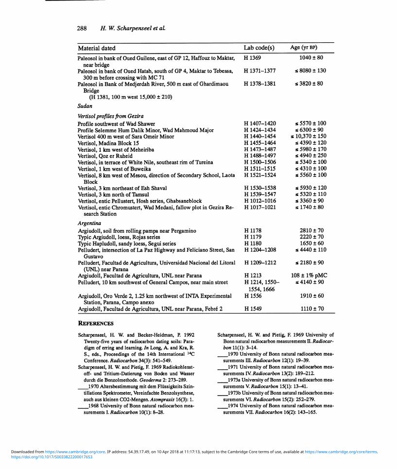
288 H. W. Scharpenseel et al.
Material dated Lab code(s) Age (yr BP)
Paleosol in bank of Oued Guilene, east of GP 12, Haffouz to Maktar, near bridge
H 1369 80
Paleosol in bank of Oued Hatab, south of GP 4, Maktar to Tebessa, 300 m before crossing with MC 71
H 1371-1377 8080 ± 130
Paleosol in Bank of Medjerdah River, 500 m east of Ghardimaou Bridge
H 1378-1381 3820 ± 80
(H 1381,100 m west 15,000 ± 210)
Sudan
Vertisol profiles from Gezira Profile southwest of Wad Shawer H 1407-1420 s 5570± 100 Profile Selemme Hum Dalik Minor, Wad Mahmoud Major H 1424-1434 s 6300 ± 90 Vertisol 400 m west of Sara Omeir Minor H 1440-1454 s 10,370 ± 150 Vertisol, Madina Block 15 H 1455-1464 s 4390 ± 120 Vertisol, l km west of Meheiriba H 1473-1487 s 5980 ± 170 Vertisol, Qoz er Ruheid H 1488-1497 s 4940 ± 250 Vertisol, in terrace of White Nile, southeast rim of Tureina H 1500-1506 s 5340 ± 100 Vertisol, l km west of Buweika H 1511-1515 s 4310 ± 100 Vertisol, 8 km west of Mesou, direction of Secondary School, Laota
Block H 1521-1524 5560 ± 100
Vertisol, 3 km northeast of Esh Shaval H 1530-1538 s 5930 ± 120 Vertisol, 3 km north of Tamsul H 1539-1547 s 5320 ± 110 Vertisol, entic Pellusert, Hosh series, Ghabsaneblock H 1012-1016 s 3360 ± 90 Vertisol, entic Chromustert, Wad Medani, fallow plot in Gezira Re-
search Station
Argentina
1017-1021 1740 ± 80
Argiudoll, soil from rolling pampa near Pergamino H 1178 2810 ± 70 Typic Argiudoll, loess, Rojas series H 1179 2220 ± 70 Typic Hapludoll, sandy loess, Segui series H 1180 1650 ± 60 Pelludert, intersection of La Paz Highway and Feliciano Street, San
Gustavo H 1204-1208 4440 ± 110
Pelludert, Facultad de Agricultura, Universidad Nacional del Litoral (UNL) near Parana
H 1209-1212 2180 ± 90
Argiudoll, Facultad de Agricultura, UNL near Parana H 1213 108 ± 1% pMC Pelludert, 10 km southwest of General Campos, near main street H 1214,1550- s 4140 ± 90
1554,1666 Argiudoll, Oro Verde 2, 1.25 km northwest of INTA Experimental
Station, Parana, Campo anexo H 1556 60
Argiudoll, Facultad de Agricultura, UNL near Parana, Febre 2 H 1549 1110 ± 70
REFERENCES
Scharpenseel, H. W. and Becker-Heidman, P. 1992 Twenty-five years of radiocarbon dating soils: Para- digm of erring and learning. In Long, A. and Kra, R.
S., eds., Proceedings of the 14th International 14C
Conference. Radiocarbon 34(3): 541-549. Scharpenseel, H. W. and Pietig, F. 1969 Radiokohlenst-
off- and Tritium-Datierung von Boden and Wasser durch die Benzolmethode. Geoderma 2: 273-289.
1970 Altersbestimmung mit dem Flussigkeits Szin- tillations Spektrometer, Vereinfachte Benzolsynthese, auch aus kleinen C02-Mengen. Atompraxis 16(3):1.
1968 University of Bonn natural radiocarbon mea- surements I. Radiocarbon 10(1): 8-28.
Scharpenseel, H. W. and Pietig, F. 1969 University of Bonn natural radiocarbon measurements II. Radiocar- bon 11(1): 3-14.
1970 University of Bonn natural radiocarbon mea- surements III. Radiocarbon 12(1):19-39.
1971 University of Bonn natural radiocarbon mea- surements IV. Radiocarbon 13(2):189-212.
1973a University of Bonn natural radiocarbon mea- surements V. Radiocarbon 15(1):13-41.
1973b University of Bonn natural radiocarbon mea- surements VI. Radiocarbon 15(2): 252-279.
1974 University of Bonn natural radiocarbon mea- surements VII. Radiocarbon 16(2):143-165.
https://doi.org/10.1017/S0033822200017653Downloaded from https://www.cambridge.org/core. IP address: 54.39.17.49, on 10 Apr 2018 at 11:17:13, subject to the Cambridge Core terms of use, available at https://www.cambridge.org/core/terms.

Bonn-Hamburg 14C Dating of Soils 289
Scharpenseel, H. W., Pietig, F. and Schiffman, H. 1976 Hamburg University radiocarbon dates I. Radiocar- bon 18(3): 268-289.
Scharpenseel, H. W., Pietig, F. and Tamers, M. A. 1968 University of Bonn natural radiocarbon measurements I. Radiocarbon 10(1): 8-28.
Scharpenseel, H. W. and Schiffman, H. 1977 Hamburg University radiocarbon dates H. Radiocarbon 19(2):
170-182. Scharpenseel, H. W., Schiffman, H. and Becker, P. 1984
Hamburg University radiocarbon dates IV. Radiocar- bon 26(3): 367-383.
Scharpenseel, H. W., Schiffman, H. and Hintze, B. 1984 Hamburg University radiocarbon dates III. Radiocar- bon 26(2):196-205.
APPENDIX 1: ANNOTATED BIBLIOGRAPHY
(Publications based partly to completely on 14C dates on soil and secondary carbonates in soils; arranged in chronological order)
Muckenhausen, E., Scharpenseel, H. W. and Pietig, F. 1968 Zum Alter des Plaggeneschs. Eiszeitalter and Ge- genwart 19:190-196.
Description of Plaggepts Table of three 14C-dated Plaggepts, in 10-cm intervals Table of 14 additional Plaggept 14C-dating results
Scharpenseel, H. W., Ronzani, C. and Pietig, F. 1968 Comparative age determination on different humic-matter fractions. In Isotopes and Radiation in Soil Organic Matter Studies. Vienna, IAEA: 67-73.
Fractionation method; table of 14C dating, by 10-cm intervals, of Udoll, Aquoll, Rendoll, Hapludalf, Spo- dosol soils; table of comparative humus SOM fraction dates of Udalf, two Spodosols, Histosol and Aquoll, indicating highest C residence time in the Gray humic acid fractions
Scharpenseel, H. W, Tamers, M. A. and Pietig, F. 1968 Altersbestimmung von Boden durch die Radiokohlen- stoffdatierungsmethode. Zeitschrift fur Pflanzenernahrung and Bodenkunde 119(1): 44-52.
Tables with separate sets of 14C dates: Mollisols of Germany, Hapludalfs, Rendolls and Histosols, Plaggepts, Histosols and Spodosols
Scharpenseel, H. W, Tamers, M. A. and Pietig, F. 1968 Altersbestimmung von Boden durch dei Radiokohlen- stoffdatierungsmethode. Zeitschrift fur Pflanzenernahrung and Bodenkunde 119(1): 34-44.
Bomb-carbon curve of year-specific field-experimental crop samples and alcohol, distilled from wine of specific origin Description of sample preparation and method of benzene synthesis Reflection on rejuvenation of soil carbon Histogram of all 14C dates known through 1967, identified by soil types and Quaternary geological origin
Scharpenseel, H. W. and Pietig, F. 1969 Altersbestimmung von Boden durch die Radiokohlenstoffdatierungs- methode. Zeitschrift fur Pflanzenernahrung and Bodenkunde 122(2):145-152.
Table of 14C dates from Hapludalfs, probably formerly Udolls; dating of individual genetic horizons and subhorizons; the highest 14C ages always occur in argillic horizons Table with 14C dates of paleosols (Mollisols), some > 10,000 BP
Scharpenseel, H. W. 1972 Natural radiocarbon measurement of soil and organic matter fractions and on soil pro- files of different pedogenesis. Proceedings of the 8th International Conference on RadiocarbonDating. Well- ington, New Zealand, Royal Society: 384-393.
Table of 14C dates on SOM fractions from Histosol, Spodosols, Aquoll, Udoll and a Paleudoll Table of 14C dates of different particle fractions of silt and clay, compared with charcoal samples; highest age among particle fractions in fine silt and coarse clay Diagrams with date-points: regression line and correlation equation for available dates of Spodosols, Alfisols, Udolls, Plaggepts and Vertisols Age vs. depth curves of 39 Vertisols in diagram, split into six fields of different countries of origin
https://doi.org/10.1017/S0033822200017653Downloaded from https://www.cambridge.org/core. IP address: 54.39.17.49, on 10 Apr 2018 at 11:17:13, subject to the Cambridge Core terms of use, available at https://www.cambridge.org/core/terms.

290 H. W. Scharpenseel et al.
Scharpenseel, H. W. 1972 Messung der naturlichen C-14 Konzentration in der organischer Substanz von rezenten "den. Eien Zwischenbilanz. Zeitschrift fur Pflanzenernahrung undBodenkunde 133(3): 241-263.
Balance of work: Reference collection, 12 figures and 3 tables, summarizing all our 14C-dating of soil samples, profile scans, SOM-fractions and integral regression/correlation curves
Scharpenseel, H. W. 1974 Zur Berechtigung der Interpretation naturlicher Radiokohlenstoffinessungen an or- ganischem Kohlenstoff CaCO3-reicher Boden. Mitteilungen der Deutschen Bodenkundlichen Gesellschaft 18:198-201.
Seven Udoll, Vertisol and Hapludlf profiles from Czechoslovakia, Bulgaria, Italy and Germany; '4C dat- ing and 813C measurement in all genetic horizons
Scharpenseel, H. W. 1975 Relative age sequence of fractions of soil organic matter. Application of Nuclear Methods in Biology andAgriculture. ENSA (European Society of Nuclear Methods in Agriculture) 5:10-17.
Table of SOM fraction dating, including Sephadex gel fractionation Setup for preparative gel fractionation as a graph
Scharpenseel, H. W. 1975 Relativalter and Sukzession von Fraktionen der organischen Bodensubstanz. Mittei- lungen der Deutschen Bodenkundlichen Gesellschaft 22: 453-466.
Soil fraction 14C dating; all available fractionation methods are compared. Dimethylsulfoxide extract as
well as 6N HCl hydrolysis residue seem to produce the highest 14C ages
Scharpenseel, H. W. and Schiffmann, H. 1977 Radiocarbon dating of soils, a review. Zeitschrift fiirPflanzen- ernahrung and Bodenkunde 140:159-174.
Review of the state of the art
Scharpenseel, H. W. 1977 The search for biologically inert and lithogenic carbon in recent soil organic matter. Soil Organic Matter Studies. Volume 2. Vienna, IAEA: 193-200.
All fractionation methods including gel fractions and repetitive 6N HCl-hydrolysis dating results and comparison. Repetitive acid hydrolysis seems to be the best method, but laborious sample preparation methods prohibit routine use.
Blackburn, G., Sleeman, J. R. and Scharpenseel, H. W. 1979 Radiocarbon measurements and soil micromor- phology as guides in the formation of Gilgai at Kaniva, Victoria. Australian Journal of Soil Research 17:1- 15.
Four Vertisol profiles, sampled in 10-cm intervals; one mound and one depression profile each from Lillimur and Miram were 14C-dated. Mound samples are superior in carbon residence time to depression samples.
Meyer-Spasche, H. and Scharpenseel, H. W. 1980 Die Grundbelastung von Boden mit 14C and dessen Transfer zum Menschen. Zeitschrift, f iir Pflanzenernahrungnnd Bodenkunde 143(5): 537-545.
Bomb-carbon curve up to 1980, mainly from wine and grass Bomb-carbon transfer pCi/gC in grass, milk and human hair Natural 14C activity by layer in a pine forest, pasture and cropland, also as 14C activity pCi/gC
Stephan, S., Berrier, J., De Petre, A. A., Jeanson, C., Kooistra, M. J., Scharpenseel, H. W. and Schiffman, H. 1983 Characterization of in situ organic matter constituents in Vertisols from Argentina, using submicro- scopic and cytochemical methods. First report. Geoderma 30: 21-34.
Carbon dating of Vertisol profiles as part of very detailed soil investigations
Schleser, G. H., Bertram, H. G. and Scharpenseel, H. W. 1983 Aussagen fiber Bildungsprozesse tunesischer Kalkkrusten mittles 13C/12C-Isotopenanalysen. Mitteilungen der Deutschen Bodenkundlichen Gesellschaft 38: 573-578.
Checking the ad ascensum and ad descensum hypothesis of calcrete formation by changes in 13C concen- tration throughout a profile
https://doi.org/10.1017/S0033822200017653Downloaded from https://www.cambridge.org/core. IP address: 54.39.17.49, on 10 Apr 2018 at 11:17:13, subject to the Cambridge Core terms of use, available at https://www.cambridge.org/core/terms.
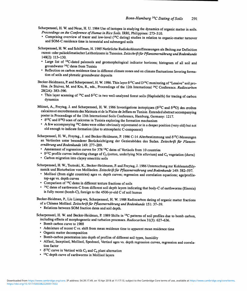
Bonn-Hamburg 14C Dating of Soils 291
Scharpenseel, H. W. and Neue, H. U. 1984 Use of isotopes in studying the dynamics of organic matter in soils. Proceedings on the Conference of Humus in Rice Soils. IRRI, Philippines: 273-310.
Comprising overview of tracer and low-level (14C dating) studies in relation to organic-matter turnover and SOM-C residence time in terrestrial and submerged soils
Scharpenseel, H. W. and Schiffman, H. 1985 Natiirliche Radiokohlenstoffmessungen als Beitrag zur Definition rezent- oder palaoklimatischer Leithorizonte in Tunesien. Zeitschrif t fur Pflanzenernahrung and Bodenkunde 148(2):113-130.
Large list of 14C-dated paleosols and geomorphological indicator horizons; histogram of all soil and groundwater 14C dates from Tunisia Reflection on carbon residence time in different climate zones and on climate fluctuations favoring forma- tion of soils and phreatic groundwater deposits
Becker-Heidmann, P. and Scharpenseel, H. W. 1986. Thin layer b13C and D14C monitoring of "Lessive" soil pro- files. In Stuiver, M. and Kra, R., eds., Proceedings of the 12th International 14C Conference. Radiocarbon 28(2A): 383-390.
Thin layer scanning of 14C and b13C in two well-analyzed forest soils (Hapludalfs) for tracing of carbon dynamics
Mtimet, A., Freytag, J. and Scharpenseel, H. W. 1986 Investigations isotopiques (813C and 8180) des crofltes calcaires et encrofltements des Matmata et de la Plaine de Jeffara en Tunisie. Extended abstract accompanying poster in Proceedings of the 13th International Soils Conference, Hamburg, Germany: 1217.
813C and b180 scan of calcretes in Tunisia exploring the formation mechanism A few accompanying 14C dates were either obviously rejuvenated or in a deeper position (very old) but not old enough to indicate formation (due to atmospheric C-component)
Scharpenseel, H. W., Freytag., J. and Becker-Heidmann, P. 1986 C-14 Alterbestimmung and b13C-Messungen an Vertisolen unter besonderer BerUcksichtigung der Gezieraboden des Sudan. Zeitschrift fiir Planzen- ernahrung and Bodenkunde 149: 277-289.
Assessment of regression curves for 37814C dates of Vertisols from 10 countries b13C profile curves indicating change of C3 (cotton, underlying Nile alluvium) and C4 vegetation (durra) Carbon migration into clayey smectitic soils
Scharpenseel, H. W., Tsutsuki, K., Becker-Heidmann, P. and Freytag, J. 1986 Untersuchung zur Kohlenstoffdy- namik and Bioturbation von Mollisolen. Zeitschrift fur Pflazenernahrung and Bodenkunde 149: 582-597.
Mollisol (from eight countries) ages vs. depth curves; regression and correlation equations; age/profile- top-age vs. depth curves Comparison of 14C dates in different texture fractions of soils
. 14C dates of earthworm-C from different soil depth layers indicating that body-C of earthworms (Eisenia) is fully recent (bomb-C), foreign to the 4500-yr-old C of soil humus
Becker-Heidman, P., Liu Liang-wu, Scharpenseel, H. W. 1988 Radiocarbon dating of organic matter fractions of a Chinese Mollisol. Zeitschrift fur Pflazenernahrung and Bodenkunde 151: 37-39.
Relations between SOM fraction dates and soil depth.
Scharpenseel, H. W. and Becker-Heidman, P. 1989 Shifts in 14C patterns of soil profiles due to bomb carbon, including effects of morphogenetic and turbation processes. Radiocarbon 31(3): 627-636.
Bomb carbon curve to 1988 Admixture of recent C vs. shift from mean residence time to apparent mean residence time Organic matter decomposition Bomb-carbon penetration into depth of profiles of different soil types, humidity Alfisol, Inceptisol, Mollisol, Spodosol, Vertisol ages vs. depth regression curves, regression and correla- tion factor bi3C curve in Vertisol with C3 and C4 plant alternation 14C depth curve of earthworms in Mollisol layers
https://doi.org/10.1017/S0033822200017653Downloaded from https://www.cambridge.org/core. IP address: 54.39.17.49, on 10 Apr 2018 at 11:17:13, subject to the Cambridge Core terms of use, available at https://www.cambridge.org/core/terms.
292 H. W. Scharpenseel et al.
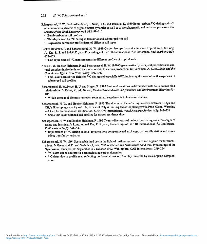
Scharpenseel, H. W., Becker-Heidman, P., Neue, H. U. and Tsutsuki, K. 1989 Bomb-carbon, '4C-dating and 13C-
measurements as tracers of organic matter dynamics as well as of morphogenetic and turbation processes. The
Science of the Total Environment 81/82: 99-110. Bomb carbon in soil profiles Thin-layer scan by 14C dating in terrestrial and submerged rice soil
Regression curves for profile dates of different soil types
Becker-Heidman, P. and Scharpenseel, H. W. 1989 Carbon isotope dynamics in some tropical soils. In Long,
A., Kra, R. S. and Srdo, D., eds, Proceedings of the 13th International '4C Conference. Radiocarbon 31(3):
672-679. Thin-layer scan of 14C measurements in different profiles of tropical soils.
Neue, H. U., Becker-Heidman, P. and Scharpenseel, H. W. 1990 Organic matter dynaics, soil properties and cul-
tural practices in ricelands and their relationship to methan production. In Bouwman, A. F., ed., Soils and the
Greenhouse Effect. New York, Wiley: 456-466. Thin-layer scan of rice fields by 14C dating and especially b13C, indicating the zone of methanogenesis in
submerged soil profiles
Scharpenseel, H. W., Neue, H. U. and Singer, St. 1992 Biotransformations in different climate belts; source-sink
relationships. In Kubat, K., ed., Humus, Its Structure and Role in Agriculture and Environment. Elsevier: 91- 105.
Within context of biomass turnover, some minor supplements to low-level studies
Scharpenseel, H. W. and Becker-Heidman, P. 1993 The dilemma of conflicting interests between C02's and
CH4's IR trapping capacity and role, in case of CO2 as limiting factor for plant growth. Proc. Global Warming
- A Call for International Coordination. SUPCON International. World Resource Review 4(2): 242-258.
Some thin-layer scanned soil profiles for carbon residence time
Scharpenseel, H. W. and Becker-Heidman, P. 1992 Twenty-five years of radiocarbon dating soils: Paradigm of
erring and learning. In Long, A. and Kra, R. S., eds., Proceedings of the 14th International 14C Conference.
Radiocarbon 34(3): 541-549. Implications of 14C dating of soils: rejuvenation; compartmental exchange; carbon elluviation and illuvi-
ation; transfer by turbation
Scharpenseel, H. W. 1994 Sustainable land use in the light of resilience/elasticity to soil organic matter fluctu-
ations. In Greenland, D. and Szabolcs, I, eds., Soil Resilience and Sustainable Land Use. Proceedings of the
Symposium, Budapest 28 September to 2 October 1992. Wallingford, CAB International: 249-264. 14C dates due to soil profile scan indicating carbon dynamics 14C dates due to profile scan reflecting preferential link of C to clay minerals by clay-organic complex-
ation
https://doi.org/10.1017/S0033822200017653Downloaded from https://www.cambridge.org/core. IP address: 54.39.17.49, on 10 Apr 2018 at 11:17:13, subject to the Cambridge Core terms of use, available at https://www.cambridge.org/core/terms.
Bonn-Hamburg 14C Dating of Soils 293
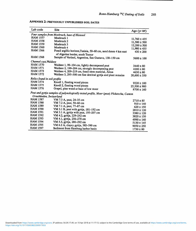
APPENDIX 2: PREVIOUSLY UNPUBLISHED SOIL DATES
Lab code Site Age (yr BP) Four samples from Mosbruch, base of Histosol HAM 1557 Mosbruch 1 11,760 ± 435 HAM 1558 Mosbruch 2 11 580 ± 500 HAM 1559 Mosbruch 3
, 12,200 ± 500
HAM 1560 Mosbruch 4 11,980 ± 435 HAM 1566 Fossil argillic horizon,Tunisia, 50-60 cm, sand dunes 4 km east 430 ± 200
HAM 1568 of Algerian border, south Tozeur
Sample of Vertisol, Argentina, San Gustavo,130-150 cm 100 Channel cas4 Waldsee HAM 1570 Waldsee 1, 99-104 cm, lightly decomposed peat 3440 80 HAM 1571 Waldsee 2,199 204 cm, strongly decomposing peat 4200 80 HAM 1573 Waldsee 4, 209-219 cm, fossil stem material, Alnus 4630 80 HAM 1572 Waldsee 3, 295-300 cm fine detritral gyttja and plant remains 20,600 350 Relics found in soil profile HAM 1574 Knodl 1, floating wood pieces 9220 100 HAM 1575 Knodl 2, floating wood pieces 25,500 900 HAM 1576 Grapel, pine wood at base of low moor 8700 160 Peat and gyttja samples of palynologically tested profile, Moor (peat) Plidutscha, Canton
Graubunden, Switzerland HAM 1587 VM 7.3 A, peat, 24-35 cm 2710 ± 85 HAM 1588 VM 7.2 A, peat, 50-60 cm 910 ± 140 HAM 1589 VM 7.1 A, peat, 77-,87 cm 620 ± 150 HAM 1590 VM 3.1 B, peat with gyttja, 181-192 cm 2810± 120 HAM 1591 VM 3.1 A, gyttja with peat, 195-207 cm 3380 ± 120 HAM 1592 VM 4.2, gyttja, 229-242 cm 3820 ± 150 HAM 1593 VM 4.1, gyttja, 256-270 cm 4990 ± 140 HAM 1594 VM 5.3, gyttja, 280-292 cm 5130± 145 HAM 1595 VM 6.2 A, clayey gyttja, 382-390 cm 9050 ± 250 HAM 1597 Sediment from Hamburg harbor basin 1730 ± 80
https://doi.org/10.1017/S0033822200017653Downloaded from https://www.cambridge.org/core. IP address: 54.39.17.49, on 10 Apr 2018 at 11:17:13, subject to the Cambridge Core terms of use, available at https://www.cambridge.org/core/terms.