RADAR REMOTE SENSING FOR ANALYSING HISTORICAL SITES … fileAbstrak: Lembah Bujang merupakan pusat...
14
Norzailawati et al, International Journal of Environment, Society and Space, 2017, 5(1), 17-30 17 RADAR REMOTE SENSING FOR ANALYSING HISTORICAL SITES AT BUJANG VALLEY, KEDAH, MALAYSIA Norzailawati M.N. a *, Alias A.A. a , Akma R.S. a and Zuraini M.A. b a Urban and Regional Planning Department, Kulliyah of Architecture and Environmental Design, International Islamic University of Malaysia, 50728 Kuala Lumpur, Malaysia. b Department Of Building Surveying, Faculty Of Built Environment, University of Malaya, 50603 Kuala Lumpur, Malaysia. Abstract: Bujang Valley was an international cultural and commercial crossroad ever since 2000 years ago. Its history, potential, economic and socio-cultural administrator and significance, its art and architecture as well as diplomatic relationships offer fertile ground for scholarly investigations. However, the issue of these pre-historic sites being demolished in secrecy for modern development brings in a further analysis. With that, this research aims to identify potential mound areas, which are two study areas consisting of Bujang Valley and Sungai Batu Complex, using the RADARSAT. Local Adaptive Filtering and Feature Extraction were applied to multi- temporal images of RADARSAT for years 2003 and 2014 to identify potential mounds. Two study areas were selected using ENVI 4.8. The finding shows that The Local Adaptive Filtering on GAMMA Map filter is one of the best techniques in identifying potential mounds areas immediately. This technique proves to be a reliable guide in historical site detection in Malaysia which will also contribute in the chronology of the land use development planning in Bujang Valley. Simultaneously, this technique will also aid in making recommendations for land use planning guidelines in preservation and conservation of heritage sites. Keywords: Remote Sensing, RADARSAT, Filtering Techniques, Historical sites and Urban Planning Abstrak: Lembah Bujang merupakan pusat pertembungan budaya dan komersil antarabangsa sejak 2000 tahun lalu. Sejarah, potensi, pentadbiran ekonomi dan sosio-budaya, seni bina serta hubungan diplomatiknya membuka peluang yang luas bagi tujuan kajian para ilmuan. Namun begitu, isu berkaitan dengan kemusnahan tinggalan pra-sejarah yang dimusnahkan secara diam memerlukan analisis rentetan. Dengan itu, tujuan penyelidikan ini adalah untuk mengenal pasti kawasan berpotensi di dua kawasan kajian iaitu Lembah Bujang dan Kompleks Sungai Batu dengan menggunakan satelit RADARSAT. Teknik penapisan Local Adaptive dan Pengekstrakan ciri digunakan pada imej Radarsat bagi tahun 2003 dan 2014 bagi tujuan mengenalpasti kawasan tinggalan yang berpotensi. Penemuan kajian menunjukkan bahawa teknik penapisan Local Adaptive melalui proses penapis peta GAMMA merupakan teknik yang terbaik dalam mengesan tinggalan dikawasan kajian. Teknik tersebut turut membuktikan keupayaannya dalam mengesan kawasan tinggalan sejarah yang mana dalam masa yang sama melibatkan pembangunan gunatanah di Lembah Bujang. Hatta, kajian ini juga turut menyokong pembentukan garispanduan kepada perancangan gunatanah sekaligus memulihara dan memelihara kawasan warisan. Kata kunci: Penderiaan Jauh, RADARSAT, Teknik Penapisan, Tapak Sejarah dan Perancang Bandar. a* E-mail: [email protected]
Transcript of RADAR REMOTE SENSING FOR ANALYSING HISTORICAL SITES … fileAbstrak: Lembah Bujang merupakan pusat...

Norzailawati et al, International Journal of Environment, Society and Space, 2017, 5(1), 17-30
17
RADAR REMOTE SENSING FOR ANALYSING
HISTORICAL SITES AT BUJANG VALLEY, KEDAH, MALAYSIA
Norzailawati M.N. a*, Alias A.A. a, Akma R.S. a and Zuraini M.A.b
a Urban and Regional Planning Department, Kulliyah of Architecture and Environmental Design,
International Islamic University of Malaysia, 50728 Kuala Lumpur, Malaysia.
b Department Of Building Surveying, Faculty Of Built Environment, University of Malaya, 50603
Kuala Lumpur, Malaysia.
Abstract: Bujang Valley was an international cultural and commercial crossroad ever since 2000 years ago. Its
history, potential, economic and socio-cultural administrator and significance, its art and architecture as well as
diplomatic relationships offer fertile ground for scholarly investigations. However, the issue of these pre-historic
sites being demolished in secrecy for modern development brings in a further analysis. With that, this research
aims to identify potential mound areas, which are two study areas consisting of Bujang Valley and Sungai Batu
Complex, using the RADARSAT. Local Adaptive Filtering and Feature Extraction were applied to multi-
temporal images of RADARSAT for years 2003 and 2014 to identify potential mounds. Two study areas were
selected using ENVI 4.8. The finding shows that The Local Adaptive Filtering on GAMMA Map filter is one of
the best techniques in identifying potential mounds areas immediately. This technique proves to be a reliable
guide in historical site detection in Malaysia which will also contribute in the chronology of the land use
development planning in Bujang Valley. Simultaneously, this technique will also aid in making
recommendations for land use planning guidelines in preservation and conservation of heritage sites.
Keywords: Remote Sensing, RADARSAT, Filtering Techniques, Historical sites and Urban Planning
Abstrak: Lembah Bujang merupakan pusat pertembungan budaya dan komersil antarabangsa sejak 2000 tahun
lalu. Sejarah, potensi, pentadbiran ekonomi dan sosio-budaya, seni bina serta hubungan diplomatiknya
membuka peluang yang luas bagi tujuan kajian para ilmuan. Namun begitu, isu berkaitan dengan kemusnahan
tinggalan pra-sejarah yang dimusnahkan secara diam memerlukan analisis rentetan. Dengan itu, tujuan
penyelidikan ini adalah untuk mengenal pasti kawasan berpotensi di dua kawasan kajian iaitu Lembah Bujang
dan Kompleks Sungai Batu dengan menggunakan satelit RADARSAT. Teknik penapisan Local Adaptive dan
Pengekstrakan ciri digunakan pada imej Radarsat bagi tahun 2003 dan 2014 bagi tujuan mengenalpasti kawasan
tinggalan yang berpotensi. Penemuan kajian menunjukkan bahawa teknik penapisan Local Adaptive melalui
proses penapis peta GAMMA merupakan teknik yang terbaik dalam mengesan tinggalan dikawasan kajian.
Teknik tersebut turut membuktikan keupayaannya dalam mengesan kawasan tinggalan sejarah yang mana dalam
masa yang sama melibatkan pembangunan gunatanah di Lembah Bujang. Hatta, kajian ini juga turut
menyokong pembentukan garispanduan kepada perancangan gunatanah sekaligus memulihara dan memelihara
kawasan warisan.
Kata kunci: Penderiaan Jauh, RADARSAT, Teknik Penapisan, Tapak Sejarah dan Perancang Bandar.
a* E-mail: [email protected]

Norzailawati et al, International Journal of Environment, Society and Space, 2017, 5(1), 17-30
18
INTRODUCTION
The Bujang Valley, a place located in northern Malaysia (Kuala Muda, Kedah) is one of the most
remarkable archaeological sites. Bujang Valley was an international cultural and commercial
crossroad ever since 2000 years ago. Its history, its potential, economic and socio-cultural
administrator and significance, its art and architecture, its diplomatic relationship and so on offer
fertile ground for scholarly investigations. Apart from the Muda, another principal river is the
Merbok, while the 1217 meter Mount Jerai is the highest landmark in the area. Situated in the rice
bowl region of Kedah, the valley was home to a prosperous kingdom around the 4th century A.D
(Maznah et al, 2010). With the increase of trade in the straits of Melaka, the Bujang Valley developed
into a collecting centre for the products of the Malay Peninsula, and by the 7th century it had evolved
into an entreport. In 670 A.D, the Bujang Valley Kingdom fell under the influence of Srivijaya, but
regained its power with the weakening of the Srivijaya Empire at the end of the 11th century. It was
still existence in the 14th century but declined with the coming of Islam and Melaka as an entreport.
The exploration on this site is still continuous, and their works are still yet to finish. This has been
supported with the latest evidence, which also revealed that this civilizations covers an area of over
1000 square kilometer compared to an area previously estimated, which was only 400 square
kilometer. However, recently news stated that many of these prehistoric sites are being rapidly
destroyed due to modern land use practices with the developments of new settlements and
constructions of new townships, causing a major destruction thus requiring urgent conservation by the
local authority. Over 50 mounds and hundreds of relics that were on displayed in the nearby Bujang
Valley archaeological museum were ruined because of these developments’ encroachment.
The issue on these pre-historic ruins at archaeological sites in Bujang Valley is that they were being
secretly demolished by land developers. Some sites have been dug up from its spot near Sungai Batu
with particular mounds hidden from sight and were believed to be an old palm estate, causing the
developer to demolish them first before clearing the oil palm trees. It is an outrage that those ancient
and significant archaeological sites were not only, unprotected but was also allowed to be dug up to
make way for development. At present, most of cultural heritage legislation and management is based
on expensive and old-fashioned methods of field survey which underpin regional and national
registers of cultural heritage sites. This old method which is influenced by realistic forecasting and
lack of reliable data are costly and time consuming due to their application over large areas and
introduces unnecessary conflicts (Grøn & Loska, 2002).
SAR system (synthetic aperture radar) is one of the recent active sensors used for archaeological
investigation which can be operated from satellites and facilitate registration of small-scale
topographical features which are penetrating vegetation, variation in ground moisture, and the
occurrence of stones. It was proved particularly useful for archaeology research. It was sensitive to
linear and geometric features on the ground. It is also important to include a method called ground
trothing or the process of physically visiting (on foot) the localities surveyed to verify the data, as it
helps form the interpretation. SAR data sets, with the ability to record data beneath the earth`s surface
have been applied to a number of archaeological investigations. In the central Iberian Peninsula of
Spain, SAR data (with a 2.4-13.7m resolution) found potentially buried architecture (Ayuga et al,
2006). SAR data has also been used to detect archaeological sites that were not discovered during foot
survey (Sarah, 2009). In examining structural patterns at Petra, Jordan, SAR detected previously
unknown linear features. The data also showed ancient pathways, open subterranean chambers, and
natural landforms related to known archaeological sites. This study continues at Beidha, Jordan
through a cultural sites analysis initiative, which identified the general landscape condition of the area
(Comer, 2003). AIRSAR has also been used extensively at Angkor Wat to understand more
complicated human-environment interactions (Evans et al, 2007). Work done at an early Bronze Age
site in Israel, Leviah Enclosure (not seen in the ground or in aramid photographs) was detected with
ATR and later confirmed with excavation (Ben-Dor & Saaroni, 1997). Therefore, the objective of this
study is to identify potential mounds in two study areas consisting of Bujang Valley and Sungai Batu
Norzailawati et al, International Journal of Environment, Society and Space, 2017, 5(1), 17-30
19
Complex using RADARSAT in order to conserve the historical sites in the context of efficient land
use planning.
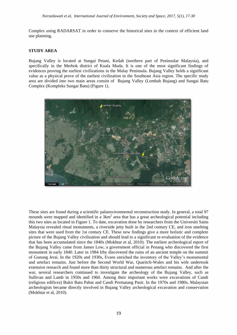
STUDY AREA
Bujang Valley is located at Sungai Petani, Kedah (northern part of Peninsular Malaysia), and
specifically in the Merbok district of Kuala Muda. It is one of the most significant findings of
evidences proving the earliest civilizations in the Malay Peninsula. Bujang Valley holds a significant
value as a physical prove of the earliest civilization in the Southeast Asia region. The specific study
area are divided into two main areas consist of Bujang Valley (Lembah Bujang) and Sungai Batu
Complex (Kompleks Sungai Batu) (Figure 1).
These sites are found during a scientific palaenvironmental reconstruction study. In general, a total 97
mounds were mapped and identified in a 3km2 area that has a great archeological potential including
this two sites as located in Figure 1. To date, excavation done by researchers from the Universiti Sains
Malaysia revealed ritual monuments, a riverside jetty built in the 2nd century CE, and iron smelting
sites that were used from the 1st century CE. These new findings give a more holistic and complete
picture of the Bujang Valley civilization and should lead to a significant re-evaluation of the evidence
that has been accumulated since the 1840s (Mokhtar et al, 2010). The earliest archeological report of
the Bujang Valley came from James Low, a government official in Penang who discovered the first
monument in early 1840. Later in 1984 Irby discovered the ruins of an ancient temple on the summit
of Gunung Jerai. In the 1920s and 1930s, Evans enriched the inventory of the Valley’s monumental
and artefact remains. Just before the Second World War, Quaritch-Wales and his wife undertook
extensive research and found more than thirty structural and numerous artefact remains. And after the
war, several researchers continued to investigate the archeology of the Bujang Valley, such as
Sullivan and Lamb in 1950s and 1960. Among their important works were excavations of Candi
(religious edifices) Bukit Batu Pahat and Candi Permatang Pasir. In the 1970s and 1980s, Malaysian
archeologists became directly involved in Bujang Valley archeological excavation and conservation
(Mokhtar et al, 2010).

Norzailawati et al, International Journal of Environment, Society and Space, 2017, 5(1), 17-30
20
THEORETICAL REVIEW
a) Remote Sensing in Archeology
In the last few decades, archeology has benefited from the development of earth observation (EO)
technologist, including optical multispectral, LiDAR and Synthetic aperture radar (SAR) remote
sensing. The latter is gaining the attention of an expanding community of scientists and archaeologists
due to the increasing availability of multi-platform, multi-band, multi-polarization and very high-
resolution satellite SAR data. It is increasingly becoming an important tool in archeology owing to
specific characteristic of its operational modalities, e.g all-weather, penetration, polarization and
interferometry. Remote sensing techniques in archeology are increasingly important components of
the technical and methodological tool set available in archeology research. The use of remote sensing
techniques allows archaeologists to uncover unique data that is unobtainable using traditional
archaeological excavation techniques. This is a non-invasive method for mapping and monitoring
potential archeological sites in an ever changing world that faces issues such as urbanization, looting
and ground water pollution that could pose threats to such sites. In spite of this, this is mostly a tool
for broad scale survey. Focused excavation and all archeological projects require a ground work in
order to verify any potential findings.
Renowned because of that, the capability of remote sensing techniques offer the advantage of
providing a synoptic view, covering large areas, and demonstrating the capability to detect features
not easily visible on the ground that may be important for archaeological applications (Brivio et al.,
2000). Nevertheless, the availability of multi-spectral data proved to be an effective data source for
paleo-geographic environment studies (Brivio et al., 2000; Parry, 1992). The use of remote sensing
techniques in both historic and prehistoric sites is well documented (Lyons & Hitchcock, 1977;
Kruckman, 1972). RADARSAT-1 provides horizontal transmit and horizontal receiver (HH) data
(793-821 km altitude), RADARSAT-2 was launched 2008, provides VV polarization, cross
polarization (HV or VH), dual polarization (HH+HV@VV+VH) and quad-polarization
(HH+VV+HV+VH). This makes RADARSAT an incredibly versatile imagery type (798km altitude).
The application of radar to a later phase of development was because the multi-spectral technique
seems to be the most promising in terms of cultural heritage site localization and monitoring, and has
already shown its usefulness (Shennan & Donoghue, 1991).
Remotely sensed optical images from satellite sensors can meet most needs in practical applications;
considering that weather-dependence limits its functional deployment under some circumstances. In
practical applications, the optical satellite images, in particular with high resolutions from sensors
such as SPOT (Chevrel et al., 1981) and IKONOS (Tanaka & Sugimura, 2001), provides excellent
legibility, but they may be affected by the clouds and weather conditions. On the other hand, SAR
images are not influenced by climate and they can be obtained day-and-night, but they suffer from a
serious intrinsic speckle or noise (Franceschetti & Lanari, 1999; Lampropoulos & Boulter, 1997). In
relation to this, the joint application of these two different kinds of data information will be of great
interest for many geological problems that is associated with remote sensing (Chen et al., 2003).
b) Filtering techniques for RADARSAT
Reducing noise from a satellite imageries are a challenge for the researchers in digital image
processing. Generally speckle noise is commonly found in synthetic aperture radar images, satellite
images and in the ultrasound medical images. It is a granular noise that inherently exists in and
degrades the quality of the Active Radar and Synthetic Aperture Radar (SAR) images. Speckle noise
in conventional radar results from random fluctuations in the return signal from an object that is no
bigger than a single image processing element. It increases the mean grey level of a local area’s
demonstrated image with speckle noise (Mokhtar et al., 2010). Several approaches for noise reduction
was filtering. Filtering is a transformation of the pixel intensity values to reveal certain image

Norzailawati et al, International Journal of Environment, Society and Space, 2017, 5(1), 17-30
21
characteristics such as enhancement of the images to improve contrast, smoothing which remove
noises known as speckles and template matching which detects known patterns by locating the
template in the images. The common filters that applied in radar imagery is local adaptive filters
including the Lee filter (Lee, 1980, 1981), Frost filter (Frost et al., 1981, 1982), Kuan filter (Kuan et
al., 1985), Gamma (MAP or Maximum A Posteriori) filter (Kuan et al., 1987; Lopes et al., 1993), and
Lee-sigma filter (Lee, 1983). All of these adaptive filters aim to effectively reduce speckle in radar
images without eliminating the fine details (Jensen, 2004).
Local Adaptive Filters, such as the Lee filter are based on the assumption that the mean and variance
of the pixel of interest are equal to the local mean and variance of all pixels within the user-selected
moving window (Lee, 1980, 1981). It was believed that it can reduce speckle/noise while preserving
the edges in the images. It removes the noise by minimizing either the mean square error or the
weighted least square estimation. This filter assumes multiplicative noise and stationary statistic.
The Frost filter replaces the pixels of interest with a weighted sum of the values within the moving
window (Frost et al., 1981, 1982). The weighting factors decrease with distance from the pixel of
interest and increase for the central pixels as variance within the window increases. The principles of
frost filters are the un-speckled pixel value estimated using a sub window of the processing window.
The size of the sub window varies as a function of the target local heterogeneity measured with the
coefficient of variation, meaning that the larger the coefficient of variation (standard deviation) the
narrow the processing sub-window. The Gamma (MAP: Maximum A Posteriori) filter was
developed by Lopes et al., (1993) based on the improved Kuan MAP filter (Kuan et al., 1987). A
priori knowledge of the probability density function of the scene is required before the filter can be
applied. It is derived under the assumption of the images scene having a Gamma Distribution, which
is believed to be more suitable to the realistic case. The advantage of this filtering technique is their
accuracy in estimating the backscattering coefficient inside homogenous area while preserving the
edge and texture of the images’ non-homogenous scene.
RESEARCH METHODOLOGY
In order to understand the phenomenon of potential mounds locations, the basic requirement is the
availability of information of site existing land using categories, topography maps, on site verification
and skill of image interpretation. In this study all these required information have been compiled and
converted into digital forms that are readily used in both data processing in Digital Image Processing
system and Geographic Information System. The latest ENVI version has been used, while ArcGIS
10.2 software system in GIS was used to generate various thematic layers that supports the main
process in detecting potential shrines areas. A complete methodology is shown in Figure 2.
a) Material and Software
The data has been collected from primary and secondary data sources. The data collected from the
primary sources include topographic maps of the area and land use map. Imageries used in this study
are RADARSAT for years of 2003 and 2014. Table 1 shows the detail specification for imageries
used in this study.

Norzailawati et al, International Journal of Environment, Society and Space, 2017, 5(1), 17-30
22
Table 1: Detail specification of RADAR imageries used in this study
SPECIFICATIONS IMAGE 1 IMAGE 3
Radarsat RADARSAT1 RADARSAT2
Acquisition Date Year 2003 Year 2014
Modes Standard Standard
Swath width Standard Standard
Band C-Band C-Band
Polarisation HH
Nominal resolution Standard: 25m Standard : 30m
Areas Bujang Valley and Sungai Batu
b) Methods
In this study, we have conducted a data collection in two different sites consisting of Bujang Valley
and Kompleks Sungai Batu. The specific inventory on material of mounds are identified and were
further used in next image processing. Complete methodology is shown in Figure 3.
Pre-Processing
The image pre-processing and data preparation techniques are the first to be carried out; these include
image rectification and subset. The image- to-map procedures has been applied to the Radar image
using a set of ground control points. The area appear in the same place both in the imagery and known
locations in the corresponding map. Urban plan was used as ancillary information in the rectification
process. The rectified data sets are then subset, producing the two sets of specific study areas. The
Radar satellite imagery shows the subset of the study area with the main shrine are located at Bujang
Valley and Kompleks Sungai Batu, Malaysia in multi-temporal images; 2003 and 2014. The process
has been done by via ENVI 4.8. The result of subset for two area of study are as shown in Figure 3:
(a) (b)
Figures 2: Subset of study area for three study area of (a) Bujang Valley;
and (b) Kompleks Sungai Batu
Norzailawati et al, International Journal of Environment, Society and Space, 2017, 5(1), 17-30
23
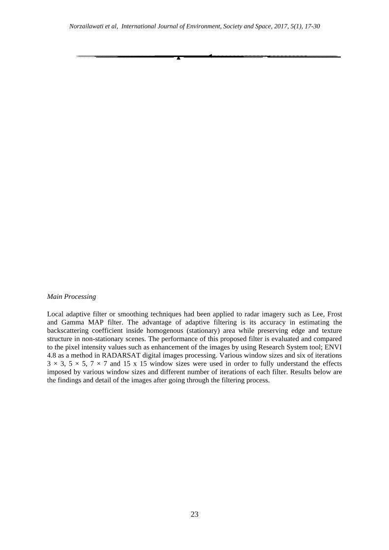
Main Processing
Local adaptive filter or smoothing techniques had been applied to radar imagery such as Lee, Frost
and Gamma MAP filter. The advantage of adaptive filtering is its accuracy in estimating the
backscattering coefficient inside homogenous (stationary) area while preserving edge and texture
structure in non-stationary scenes. The performance of this proposed filter is evaluated and compared
to the pixel intensity values such as enhancement of the images by using Research System tool; ENVI
4.8 as a method in RADARSAT digital images processing. Various window sizes and six of iterations
3 × 3, 5 × 5, 7 × 7 and 15 x 15 window sizes were used in order to fully understand the effects
imposed by various window sizes and different number of iterations of each filter. Results below are
the findings and detail of the images after going through the filtering process.
Main Processing Result Analysis Data Preparation Pre Processing Multi-Temporal Image 2003 Multi-Temporal Image 2014 (Speckle Reduction) Adaptive Filters:
Lee
Frost
Gamma
(For Visual Interpretations) Edge Enhancement
High Pass Enhancement
Low Pass Enhancement

Norzailawati et al, International Journal of Environment, Society and Space, 2017, 5(1), 17-30
24
RESULT AND DISCUSSION
Exploiting the backscattering and movements (Dore et al, 2013), we can retrieve information on the
surface characteristic (revealing in some cases the presence of archeological features); whereas by
exploiting the phase information, we can obtain the topography and subtle deformations from
inferometric analyses based on multiple data acquisition, such as tandem configuration or a multi-
temporal dataset. Topography is an important factor influencing the detection and discovery of
heritage targets (e.g. proximity of ancient rivers if located in high level wetland platforms (Garrson et
al, 2011), whereas, the identification of subtle deformations has potential relevance for preventive
diagnosis of the vulnerability of monuments and surrounding environments, thus, providing early
warning risk (Zhou et al, 2015).
The 2 sets of RADARSAT have been successfully geometrically corrected and transformed to local
mapping coordinate with RMSE ± 0.5 pixel to ensure accuracy of shrine analysis. In fact this RMSE
had been widely used as a good practice in assessing good geometric output apart from ensuring
sound configuration of ground control point, evenly distributed in study area. To evaluate proposed
filter capability in identifying potential shrine areas in Lembah Bujang, all the filters available in
ENVI have been used using default system parameters, with Lee, Frost and Gamma applied with user
defined multiplier value 1.5 purposely to assess performance of the filters in detailing potential shrine
area in study area. The finding shows, Frost filter obscured the linear features and other fine details,
resulting in very “fuzzy” filtered images. The result of Lee filter shows better in visual analysis
comparing the other filters. (Figure 4 & 5).
Norzailawati et al, International Journal of Environment, Society and Space, 2017, 5(1), 17-30
25
Figure 4: Result of Low pass filter image for different windows are tested for Bujang Valley
The term of enhancement is used to mend the alteration of the appearances of an image in such a way
that the information contained in the images are more readily interpreted by the viewer in terms of his
particular need. Four types of enhancement has been tested to compare the images’ appearances in the
study areas. The result of Edge Enhancement in Bujang Valley; and Sungai Batu imageries shows the
equation with Kernel Size at Field to 5 and Applied Images Add Back Field to 90% per 100% with
Laplacian techniques on convolution method. Same goes to high pass and low pass enhancement
Figure 5: Result of Low pass filter image for different windows are tested for Kompleks Sungai Batu

Norzailawati et al, International Journal of Environment, Society and Space, 2017, 5(1), 17-30
26
techniques, the value of kernel size is 5 and Images Add Back Field to 90% per 100%. This
convergent study has provided refinements to the problem-solving process part of the detection of
mounds area by using geospatial application technique in the heritage site. The increasing values of
the concomitant windows show the increase in the value of the brightness of the images. However,
further studies in other filtering techniques can improve the radar images to minimize the speckle
texture.
Figure 6: Result of Image Enhancement for different techniques are tested for Bujang Valley
a) Gamma Filtering 3x3, b) Edge Enhancement, c) High Pass Enhancement, d) Low Pass
Enhancement

Norzailawati et al, International Journal of Environment, Society and Space, 2017, 5(1), 17-30
27
Figure 7: Result of Image Enhancement for different techniques are tested for Kompleks Sungai Batu
a) Gamma Filtering 3 x 3, b) Edge Enhancement, c) High Pass Enhancement, d) Low Pass
Enhancement
RECOMMENDATION AND FUTURE OUTLOOKS
Conservation of Bujang Valley historical site needs effective and non-invasive techniques for periodic
monitoring. The remote sensing technique highlighted in this paper is based on the filtering
techniques using microwave radar signals of RADARSAT satellite. Future challenges substantially
deal with the exploitation, as much as possible, of the data which are currently available from both
active and passive sensors, and in turn with setting up effective and reliable automatic and/or
semiautomatic data processing strategies and the integration of the traditional ground truth activity
with numerical scientific testing. This shows that there is a great need for ground truth verification of
the result as well as for a calibration of the instruments or improvements on existing algorithm.
However, from this perspective, it can be argued that methodologies applied in a specific
archeological environment might not adequately work in other sites (Beck, 2007). In addition,
archeological surveys and findings should always be linked with the interpretation results of the
remote sensing (and vice versa) achieved.
This study proved the filtering techniques that acquired from RADARSAT (k- band) are able to
deliver a good finding in detecting mounds at Bujang Valley area. However, the capabilities of its
resolution and technique chosen need to crucially to be improved. Remote sensing for archeology,
regardless of the technological tools and procedures employed for each case, seems to be widely
accepted and established through time. New technologies (such as radar satellite images has already
been applied at various archeological sites (Stular et al., 2012; Gaber et al., 2013; Tapete et al, 2015).
New satellite sensors such as Sentinel missions, are also expected to support archeological research in
the near future (Agapiou et al., 2014). The WorldView-3 sensor with a spatial resolution of 31 cm
highlights the latest achievement of space technology. Using data with such an improved quality,
scientist can seek even more elaborate details for sub-surface remains and a better understanding of
archeolandscape.
Next generation of satellite data for archeological applications are expected to offer improved
technical capabilities, with higher spatial and spectral resolution to support the diverse phases of
archeological research from discovery, to documentation, from preservation to valorization. This
approach can effectively support a smart management of cultural heritage including the sustainable
“touristic exploitation” and educational activities to spread new technologies and “attitude” in the
context of natural and cultural heritage management.
CONCLUSION
Remote sensing technologies are used to support archeologists in providing useful information for
sub-surface remains, documentation of sites and landscapes and monitoring of cultural heritage sites.
Remote sensing and image analysis algorithm have been merely applied in different archeological and
cultural heritage contexts with different rate of success. Along with the technological achievement of
remote sensing sensors, new topics of interest have been also raised and alongside it are new
terminologies which include, amongst others, archeoloandscapes, coastal archeology and radar

Norzailawati et al, International Journal of Environment, Society and Space, 2017, 5(1), 17-30
28
images. In addition, remote sensing archeology can be considered as an innovative approach for
monitoring and protecting both existing sites of cultural interest and previously unsuspected buried
archeological remains. Driven from these technological innovations, the archeologists started
addressing new questions to guide their research, which can only lead to further improvements of all
the science and technologies involved. The promising, wide spread, knowledge is an indicator of what
to expect in the near future; even more institution working on remote sensing data to support
archeological investigation and cultural heritage and, at the same time, truthful transfer of knowledge
can be achieved. The goal of our research is to demonstrate the multi techniques of image processing
in attempt to identify shrine areas in heritage sites at Bujang Valley at once to improve the existing
tool of urban planning in preserving the historical sites. The use of radar images in this study shows a
good, significant, support system and is very competent for acquiring a better understanding in
identifying a potential mounds area. The future studies suggested here will provide a means for land
use planning development by using the remote sensing technology in the significant site area
especially on historical site.
ACKNOWLEDGEMENT
The authors greatly acknowledged Universiti Malaya and International Islamic University of
Malaysia for Joint research grant on Program Rakan Penyelidikan, Malaysia Remote Sensing Agency
(ARSN) and Town and Country Planning Department (JBPD), Centre for Global Archaeological
Research (CGAR), Universiti Sains Malaysia, Department of National Heritage and Universiti
Teknologi Malaysia for providing invaluable respective data used in this study. Authors sincerely
thank all referees for their suggestions to improve the manuscript.
REFERENCES
Ayuga, J.G.R., Mozota, F.B., Lopez, R. & Abadia, M.F. (2006). Application of Hyperspectral Remote Sensing
To The Celtiberian City Of Segeda, in S. Campana and M. Forte (eds), From Space to Place: 2nd
International Conference on Remote Sensing in Archaeology, Oxford: British Archaeology.
Agapiou, A., Alexakis, D. & Hadjimitsis, D.G. (2014). Evaluation of spectral sensitivity of ALOS, ASTER,
IKONOS, LANDSAT and SPOT satellite sensors intended for the detection of archaeological crop
marks. Digital Earth, 7 (5). http://dx.doi.org/10.1080/17538947.2012.674159.
Agapiou, A., Alexakis, D. D., Lysandrou, V., Sarris, A., Cuca, B., Themistocleous, K. & Hadjimitsis, D. G.
(2015). Impact of urban sprawl to cultural heritage monuments: the case study of Paphos area in Cyprus,
J. Cult. Herit., ISSN 1296-2074, http:// dx.doi.org/http://dx.doi.org/10.1016/j.culher.2014.12.006
(Available online 7 February 2015).
Alias, A.R., Powel, B., Christopher, G. & Mohamad, N.S. (2013). Development in multidimensional spatial data
models. Lecture notes in Geoinformation and Cartography (LNGSC), Springer.
Ben-Dor, E. & Saaroni, H. (1997). Video Thermal Radiometry as a tool for monitoring urban heat island. A case
study over Tel Aviv Israel. International Journal of Remote Sensing, 18 (14), 3039-3053.
Norzailawati et al, International Journal of Environment, Society and Space, 2017, 5(1), 17-30
29
Brivio, P. A., Pepe, M. & Tomasoni, R. (2000). Multispectral and multi-scale remote sensing data for
archaeological prospecting in an alpine alluvial plain. Journal of Cultural Heritage, 1, 155–164.
Chevrel, M., Courtois, M. & Weill, G. (1981). The SPOT Satellite Remote Sensing Mission. Photogrammetric.
Engineering and Remote Sensing, 47, 1163-1171.
Comer, D.C. (2003). Environmental History at an Early Prehistoric Village. An Application of Cultural site
Analysis at Beidha, Southern Jordan. Journal of GIS in Archeology, 1, 103-115.
Comer, D. & Harrower, M. (2013). Mapping Archaeological Landscapes from Space. Springer: New York, NY:
Springer. p. 276.
Chen, F., Lasaponara, R. & Masini, N. (2015). An overview of Satellite Synthetic aperture radar remote sensing
in archeology: From site detection to monitoring. Journal of Culture Heritage, 21, 5-11.
Dore, N., Patruno, J., Pottier, E. & Crespi, M. (2013). New research in polarimetric SAR technique for
archaeological purposes using ALOS PALSAR data. Archaeol. Prospection, 20, 79–87.
Franceschetti, G. & Lanari, R. (1999). Synthetic Aperture Radar Processing, CRC, 0-8493-7899-0, Boca Raton,
FL, USA.
Evans, D., Pottier, C., Fletcher, R., Hensley, S., Tapley, I., Milne, A. & Barbetti, M. (2007). A comprehensive
archaeological map of the world’s largest pre-industrial settlement complex at Angkor, Cambodia.
Proceedings of the National Academy of Sciences of the United States of America 104(36), 14277–
14282.
Frost, V. S., Stiles, J. A., Shanmugan, K. S. & Holtzman, J.C. (1982). A Model for Radar Images and Its
Application to Adaptive Digital Filtering of Multiplicative Noise. IEEE Transactions on Pattern
Analysis and Machine Intelligence, 4(2), 157-166.
Frost, V. S., Stiles, J. A., Shanmugan, K. S., Holtzman, J. C., and S. A. Smith, (1981). An Adaptive Filter for
Smoothing Noisy Radar Images. In the Proceedings of the IEEE, January 1981, 133-155.
Gaber, A., Koch, M., Griesh, H.M., Sato, M., & El-Baz, F. (2013). Near-surface imaging of a buried foundation
in the Western Desert, Egypt, using space-borne and ground penetrating radar. J. Archaeol. Sci. 40(4),
1946–1955.
Grøn, O., & Loska, A. (2002). Development of methods for satellite monitoring of cultural heritage sites.
Technical report, The Norwegian Directorate for Cultural Heritage, The Norwegian Space centre, NIKU.
Oslo.
Jensen, J.R. (2004). Introductory Digital Image Processing—a Remote Sensing Perspective. Upper Saddle
River, NJ: Prentice Hall, 3rd Ed., 526 p.

Norzailawati et al, International Journal of Environment, Society and Space, 2017, 5(1), 17-30
30
Kruckman, L. (1972). The Techniques and Application of Aeril Photography to Anthropology; A Bibliography.
Coun. Planning Librarians Exch. Biblio. #339. Monticello, 111.
Kuan, D. T., Sawchuk, A. A., Strand, T. C. & Chavel, P. (1985). Adaptive Noise Smoothing Filter for Image
with Signal-Dependent Noise. IEEE Transactions on Pattern Analysis and Machine Intelligence, 7(2),
165-177.
Kuan, D. T., Sawchuk, A. A., Strand, T. C., & Chavel, P. (1987). Adaptive Restoration of Images with Speckle.
IEEE Transactions on Acoustics, Speech, and Signal Processing, 35(3), 373-383.
Lee, J.S., Jurkevich, L., Dewaele, P., Wambacq, P., & Oosterlinck, A. (1994). Speckle Filtering of Synthetic
Aperture Radar Images: A Review. Remote Sensing Review, 8(3)13-340.
Lyons, T.R. & Hitchcock, R.K. (Eds.), (1977). Aerial Remote Sensing Techniques in Archaeology. Reports of
the Chaco Centre, No 2, US Department of the Interior, National Park Service, Cult Res Mgt Dew,
Washington, D. C.
Maznah, W.O., Syakirah, M., Razanawati, N., Aluyah, J. & Syazliyati, I. (2010). Hidden Tales of the Bujang
Valley. Asian Culture and History. 2(2), 221-230.
Mokhtar, S., Jaffrey, A., Jalil, O. & Azman, A. (2010). Issues and Problem of Previous Studies in the Bujang
Valley and The Discovery of Sungai Batu. In Chia, S. & Andaya, B.W. (eds), Bujang Valley and Early
Civilisations in Southeast Asia. Department of National Heritage, Ministry of Information,
Communications and Culture, Malaysia. pp 1-26.
Nayan, P., Abishek, S. & Kruti, D. (2014). A study of Digital Image Filtering Techniques in Spatial Image
Processing. Introduction Conference on Convergence of Technology. 978-1-4799-3759-2/14.
Parry, J. T. (1992). The investigative role of Landsat TM in the examination of pre-proto-historic water
management sites in northeast Thailand, Geocarto International, 4, 5–24.
Shennan, I. & Donoghue, D.N.M. (1991). Remote sensing in archeological research. Proceedings of the British
Academy. 77, 223-232.
Štular, B., Kokalj, Z., Oštir, K., Nuninger, L (2012). Visualization of LIDAR-derived relief models for detection
of archaeological features. J. Archaeol. Sci. 39, (11), 3354–3360.
Tanaka, S. & Sugimura. T. (2001). A new frontier of Remote Sensing from Ikonos images. International
Journal of Remote Sensing, 22, 1-5.
Tapete, D., Morelli, S., Fanti, R., & Casagli, N. (2015). Localising deformation along the elevation of linear
structures: an experiment with space-borne InSAR and RTK GPS on the Roman Aqueducts in Rome,
Italy. Appl. Geogr. 58, 65–83.
Zhou, W., Chen, F.L. & Guo, H.D. (2015). Differential radar interferometry for structural and ground
deformation monitoring: a new tool for the conservation and sustainability of cultural heritage sites,
Sustainability, 7, 1712–1729.