r o d 2 i m ri 1 G V S 0 D 2 T M Te ku i l L u K – Brighton & Hove Urban Characterisation Study...
87
Luke Bennett, Mark Thomas, Piotr Kulik, Tom Mannings, Tom Schmidt, David Griggs 2012 Hollingdean Visual Survey
-
Upload
truongminh -
Category
Documents
-
view
215 -
download
2
Transcript of r o d 2 i m ri 1 G V S 0 D 2 T M Te ku i l L u K – Brighton & Hove Urban Characterisation Study...

Luke
Ben
nett
, Mar
k Th
omas
, Pio
tr
Kulik
, Tom
Man
ning
s, To
m S
chm
idt,
Davi
d Gr
iggs
2012
Hol
lingd
ean
Visu
al
Surv
ey


Introduction Hollingdean is a residential suburb located in the northern area of the city with its boundaries defined by the railway line to the east and the south, Ditchling Road to the west, and Hollingbury Park Golf Club to the north which forms the boundary to the South Downs National Park.
The Study The purpose of this study is to create a wider vision for Hollingdean going into the future having briefly assessed how it has grown and developed over time and conducted visual surveys in the field as well as gathering secondary data to build a picture of how Hollingdean is today.
Key Stages in the Growth of Hollingdean
Mid C19 – 1920s
Harrington Farm was located between the sites now occupied by Hollingdean Terrace and the southern end of Hertford Road
Late C19 Southern areas were the industrial fringe of Brighton with a dust yard, abattoir, and waterworks. The rest of the area was open farmland.
1890s First signs of housing development with the Hollingbury Road/Roedale Road area being built.
1910s Grid layout of neighbouring Preston extended into what is now Hollingdean (north-south street orientation of terraced houses)
1920s Hertford Road area was developed 1930s Majority of farmland replaced by extensive allotments 1931 Hertford Road School built on the site of the farmhouse 1950s Estate to the east was developed (separated from earlier
development by a north-south line of low-rise terraced flats) 1960/70s Further development in the northern areas 1966 Twin tower blocks in the south opened (Dudeney Lodge and
Nettleton Court) 1980s - present
New blocks of flats to the north. The utility uses on the site of the old dust yard continue to this day. A materials recovery facility and waste transfer station has replaced the abattoir.
Source – Brighton & Hove Urban Characterisation Study January 2009 Source – Brighton & Hove Urban Characterisation Study January 2009 & www.bhlis.org

Hollingdean in 1865
Hollingdean in 1928
Source – Brighton & Hove Urban Characterisation Study January 2009 Source – Brighton & Hove Urban Characterisation Study January 2009

Hollingdean Today The map above shows the general layout of Hollingdean as it is today with the 4 character areas that this study focuses on highlighted in their own unique colour. These four areas are Lower Hollingdean, Crestway, Upper Hollingdean, and Brentwood & Lynchet.
Demographics Demographic statistics are difficult to obtain solely for Hollingdean as statistics are recorded on a ward by ward basis and Hollingdean falls into the Hollingdean and Stanmer ward which includes the smaller settlements of Coldean and Stanmer to the north. Also obtaining the most up to date information is also a challenge as the vast majority of statistical information is based on the 2001 Census which is now over 10 years old. However, the graph below gives a general idea of the population structure with the 16-24 age range showing a significantly large student population when compared to Brighton and Hove as a whole.
Source – Brighton & Hove Urban Characterisation Study January 2009
Source – http://neighbourhood.statistics.gov.uk – ONS Mid Year Estimates June 2010
With regards to the age structure the ward has a population of nearly 16,000 with in total women outnumbering men by 600. This can be seen only in the 16-24 age range and the retirement age range where women hold the clear numerical advantage whereas in the other 3 age ranges it is in fact that men who dominate, but only slightly in most instances.
With the publication of the 2011 Census data over the next 18 months it will be interesting to see how the other demographic statistics that were recorded in 2001 have changed over the 10 year period to gain an understanding of the direction in which Hollingdean is heading regarding its identity and population characteristics.
Community Views In 2011 Hollingdean Community Centre conducted a questionnaire with nearly 200 residents responding with their views on various issues that affect the area. Of the people surveyed 55% had lived in the area for over 10 years and 84% of respondents said they were either ‘fairly’ or ‘very satisfied’ with the Hollingdean area. These 2 statistics in particular give an impression that the residents of Hollingdean do enjoy living in the area. When residents were asked what their 3 favourite things about the area were there were some key answers that stood out. Most notably these were:
Good bus service (38 votes) Open Space and access to the Downs (31 votes) Close to town (26 votes) Neighbours (23 votes) Quiet (22 votes) Schools (21 votes) Handy shops (20 votes)
However, some of the resident’s least favourite things included:
Litter (25 votes) Traffic Speed (18 votes) Dog mess (16 votes) Student houses (13 votes) Anti Social Behaviour (10 votes)
Source – http://neighbourhood.statistics.gov.uk – ONS Mid Year Estimates June 2010

When asked what they felt could improve Hollingdean, residents suggested:
More trees (11 votes) A 20mph speed limit (8 votes) Planting at the Dip (6 votes) More activities in the park (5 votes) Less student housing (4 votes)
It is clear that the residents of Hollingdean have some strong views on the area that they live in with a range of positive and negative opinions expressed. As the results of the questionnaire show regarding residents favourite and least favourite things about the area it is clear that the number of good things that were said appear to outweigh the number of bad things, at least numerically. Despite this even fewer residents offer suggestions of possible improvements and when asked only 23% of respondents said that they would like to have more say about what happens in Hollingdean. This figure can be interpreted in one of two ways. Firstly, the other 77% of residents may feel that they already have enough say in what happens in the area, or, secondly, they are simply not interested or do not have the time to have a stronger influence on the area in which they live. If the latter point is indeed true then Hollingdean has a major hurdle to overcome when improving and enhancing the area in the future, if this statistic is reflective of the whole population, as any change from within will need as much support as possible to show that the residents want to develop and change Hollingdean for the better.
However, the Community Centre that conducted the questionnaire is managed by the Hollingdean Development Trust which is a charity dedicated to addressing issues of poverty, deprivation and education within the Hollingdean area and that works to attract funding for resident-led initiatives. So the Hollingdean community clearly has made some key steps in enhancing the area, with this leadership group, with key goals and targets to achieve.

Streetscape
Introduction Streetscapes are the area's around and in between buildings and routes. They are also the spaces that join these and the other components of the built environment together (or not as the case may be). The characteristics of these spaces provide the setting for the life and activities of the city, and the quality of their design can dictate the quality of this life and activity (Gibbons & Oberholzer, 1991:1-4)
Hollingdean is an example of how suburbs and neighbourhoods on the urban fringe of conurbations often have a lack of thoughtful design into their streetscape. While the City of Brighton & Hove possesses squares and streets possessing distinct identities steeped in history and embodying aspects of the City itself, Hollingdean's streetscape is typical of suburbs in that it feels like it could be anywhere.
The analysis of the streetscape is divided into the four established character areas (Upper Hollingdean, Lower Hollingdean, Brentwood Rd & Lynchet Cl and Crestway). In each of these a specific case study is considered, these were selected most of all for their potential for improvements that could spread to other parts of their character areas. Within these the components of the streetscape are considered - below grade, ground level, furniture, vegetation, and architecture (which has it's dedicated section in the report), and composite - how all the components fit to together. Emphasis has been placed on firstly how this streetscape forms space, the dimension of the built environment that people use, navigate, traverse, and secondly how it communicates place, the dimension that they feel, love or hate, and identify with or feel alienated from. For each an Urban Design Analysis Tool (borrowed from CABE/DETR's The Value of Urban Design (2001)) is used to quantify and compare the successfulness of their urban design.
Hundertwasser Haus, Vienna Concert Square, Liverpool
Bracknell Town Centre, Berkshire
North Laine, Brighton

Streetscape
Upper Hollingdean The residential streetscape of Upper Hollingdean is relatively pleasant and containing a sense of place, compared to the alienating and decaying fabric of Crestway and Lower Hollingdean, although this is less so in transitional areas (such as The Dip. This is due more to architecture and layout rather than streetscape. Manmade and green frontages onto the pavement do integrate the housing nicely into the composite built environment and provide a sense of continuity without cold uniformity.
Hollingbury Park Avenue Hollingbury Park Avenue—Personalisation can create a sense of ownership
Hollingbury Park Avenue - Vegetation brightens up neighbourhoods
Hollingbury Road—A distinctive ground plane can bestow an area with identity in
an unobtrusive way
Hollingbury Terrace— Alterations to a theme can create consistency and individuality at the same
time—but maintenance is an issue
Streetscape
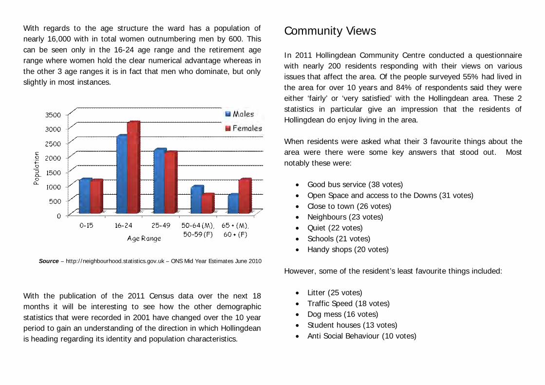
The Dip
Hollingbury Place—'The Dip'
The Dip—Traffic calming pinch points
The material on Hollingbury Place itself is largely tarmac, but there are various materials used for different shop frontages which demarcate from routes for pedestrian through-movement. Paving on Hollinbury Crescent leading down to Hollingbury Place is in a very bad state of disrepair. The poor state of paving on Hollingbury Crescent is an issue, in terms of pedestrian safety, especially those with mobility (this is exacerbated by the steepness and accent of the curve), but also in terms of a sense of place. This is the gateway to The Dip, and it would benefit from an attractive and characteristic (not to mention intact) entrance. A solution to the poor state and lack of identity in the ground level streetscape would be to expand and improve the colourful paving at the corner of Hollingbury Road. This red and grey colour scheme matches not only the red brick housing of Upper Hollingdean but also the red brick and flint wall surrounding the Waste Depot and seen in other parts of the locality (including Queensdown School Rd, an entrance to Hollingdean from Moulsecoomb, another Shopfront
Materials
Ground Plane The Dip, which it is useful to consider as including Hollinbury Crescent and the Western half of The Crossway as well as the shopping parade on Hollingbury Place, has wide pavements suitable for retail frontage, allowing room for people to use the pavement, enter/leave shops, enter/ leave cars and space for street furniture. The curb height has been dropped at certain places for accessibility issues and the pavement has been butted out in places as traffic calming measures. This has been argued by local residents to have failed to slow down traffic, who have signed an e- petition that a zebra crossing is needed (see www.brighton-hove.gov.uk).
Hollingbury Crescent—Broken ground plane
Hollingbury Road—Distinctive paving
suburb). A change in material (perhaps red brick again) and raising the road to pavement level at The Dip would clearly identify the area as pedestrian centric. Currently it is heavily traffic centric and a busy route for Hollingdean, including for buses. Any such works would have to be implemented from further up than just the small shopping parade of Hollingbury Place (e.g Stanmer Villas - Barnett Rd). Altering the curb radii at corners would also serve to slow down traffic (this has been done at the buttouts, but not other corners, which have been curb cut.

Streetscape
The Dip Furniture The street furniture on The Dip is in some places intelligently consolidated, in others cluttered. For example, a Children Crossing Sign is attached to a Street Lamp, removing the need for specific signage. However this could also be repeated for litterbins, which create an obstacle. The street furniture could benefit from a coordinated approach to street furniture. As it is the furniture is haphazard and there has obviously been no attempts at harmony (black plastic litter bins, modern light grey lamp posts, chrome bikebar, even the bollards at the ped crossings (pinch points, and buttouts) are not uniform). New street lighting is being installed, reducing the oppressive current street lamps which lurch over into the road.
Vegetation Apart from trees and shrubs in residential gardens, The Dip lacks vegetation. The width of Hollingbury Place's pavements allow space for vegetation, however this would create difficulties for people leaving their cars on the pavement side. This could be solved by having 30° parking, which would also encourage slower road traffic through The Dip. Trees, especially on corners, would also serve to slow down traffic by reducing visibility.
Hollingbury Park Avenue—Vegetation
The Dip—Thoughtful consolidation, The Dip— Cluttered furniture The Dip— Cluttered furniture poor maintenance
Apart from the bus shelter, The Dip also lacks any seating. This is probably largely from the assumption that the only reason that anybody would want to sit in this area is because they are waiting for a bus. This is probably the case, but any public realm improvements on the parade area, especially in terms of vegetation and improved paving would benefit from seating to appreciate it. Especially considering how exhausting walking around Hollingdean can be, and also from the potential views.

Urban Design Objective
Criteria Strengths Weaknesses Mark (0-5)
Character Distinct sense of place responding to local context
Location at centre of area and bottom of basin give the parade a character based on topography. (i.e. you know you’re at “The Dip”)
Built environment produces no sense of identity and fails to capitalise on local context (despite the sense of place in nearby residential neighbourhoods)
1
Continuity & Enclosure
Continuity of frontages and clearly defined public space
Buttouts and pinchpoints serve to slow down traffic, hinting at the suggestion of public space
The frontages of the shops are in dischord due to the inconsistent use of materials. The public space is not clearly defined, traffic use is dominant.
1
Quality of the Public Realm
Safe, attractive and functional public space
There is ample pavement space for a shopping parade. The pinchpoints and chicanes make crossing safer. Although the extent is debated. (Crime?) Street lighting is being improved.
Unattractive and uncoordinated materials and furniture. Distinct lack of vegetation. Cluttered and haphazard streetscape.
1
Ease of Movement
Accessible, well connected, pedestrian friendly environment
Attempts have been made to make crossing the parade safer. Ballustrades are provided (to some extent) on steep slope into the parade. Central location is walkable from most places in area.
Movement priorities in area are still auto-centric. Cluttered environment unnecessarily hinders pedestrian movement. Ballustrades are incomplete and poor design.
2
Legibility Readily understandable, easily navigable environment
- Entrances into The Dip do not communicate anything about the nature of the environment. Area not that distinctive from a residential area.
1
Adaptability Flexible and adaptable public and private environments
The relatively wide pavements (afforded by shop frontages) leaves open potential for improvements to public realm (e.g. vegetation, monuments)
Small dimensions of parade and lack of viable alternatives for traffic routes greatly restrict potential for alternative uses.
2
Diversity A varied environment offering a range of uses and experiences
Central location creates good opportunity for retail and community uses
There is a monotone and stale experience to The Dip offering no variety of experience
1
Urban Design Analysis Tool ‘The Dip’ Score – 9/35 Summary The urban fabric of The Dip creates no sense of vitality or identity. As the hub of the community (Neighbourhood Renewal Strategy) it should feel pleasant to walk through, produce confidence in visitors, shoppers, retailers and potential investors and have a sense of identity that distinguishes it, producing civic pride for the local population and making it a viable destination for those outside Hollingdean. However, The Dip achieves none of these things. The approach to urban design has been piecemeal and utilitarian, functional furniture being placed in as and when it’s needed, producing an uninspiring, colourless and cluttered streetscape. Clearly there has been no (successful at least) forward planning, coordinated design, or attempts to provide a sense of character or high quality environment. There is potential for the sense of place in residential parts of Upper Hollingdean to be spread to The Dip, in terms of theme, materials (red brick), colour (red and greys (light to dark)), form and vegetation.

Streetscape
Lower Hollingdean Lower Hollingdean is a largely industrial area, dominated by the Waste Depot and tower blocks. As such, much of its streetscape is based around masking the bulk of these and other developments (though arguably the Depot, which is subject to most camouflaging is much less unattractive than the tower blocks (Dudeney Lodge and Nettleton Court) or otherwise ameliorating their effects.
Davey Drive—Vegetation fails to mask the depot in winter
Upper Hollingdean Road—Dudeney Lodge and Nettleton Court dominate the streetscape
Hollingdean Road—Tunnels can create a claustrophobic experience for pedestrians and
Hollingdean Lane—bollards mark a clear change of route rules
Streetscape
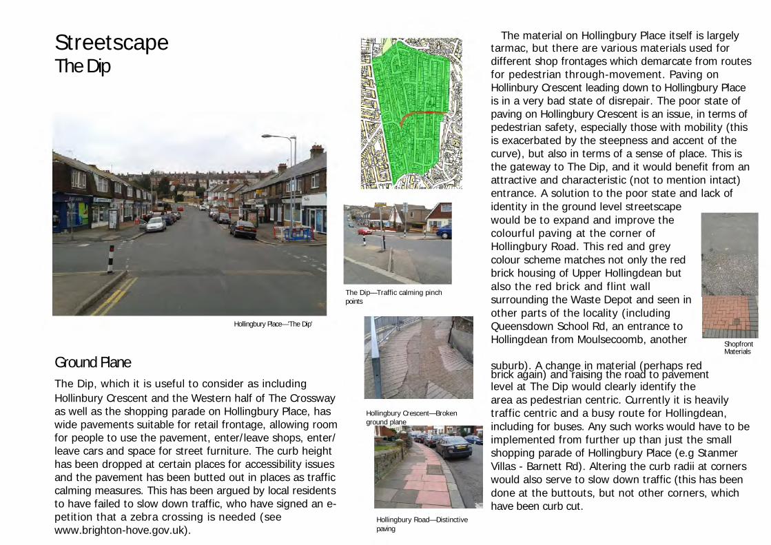
SE Gateway Ground Plane
The pavements alongside Upper Hollingdean Road are necessarily thin, due to wide roads being needed to accommodate the copious
Upper Hollingdean Rd—an uninspiring
HGV traffic created by the Waste Depot. As such the function of the Furniture entrance for Hollingdean
streetscape (much like The Dip) has been subject to the demands of road users. These thin pavements and high walls demonstrate how the pedestrian experience of this area has been inadequately considered. This is likely to be because pedestrians are not likely to linger here (as they are in areas such as The Dip), however there are retail uses in operation on Upper Hollingdean Road, as well as a pub. The latter especially could be coordinated with improvements to the public realm, as it shares the red brick of the wall surrounding the depot/ business estate. Though widening the pavements is perhaps unviable, there are other augmentations to the urban fabric that could bestow it with a sense of identity, creating a more welcoming entrance to the area, a more enjoyable pedestrian and driving experience (especially relevant considering this road is often congested) and living environment.
The pavements alongside Upper Hollingdean Road are necessarily thin, due to wide roads being needed to accommodate the copious HGV traffic created by the Waste Depot. As such the function of the streetscape (much like The Dip) has been subject to the demands of road users. These thin pavements and high walls demonstrate how the pedestrian experience of this area has been inadequately considered. This is likely to be because pedestrians are not likely to linger here (as they are in areas such as The Dip), however there are retail uses in operation on Upper Hollingdean Road, as well as a pub. The latter especially could be coordinated with improvements to the public realm, as it shares the red brick of the wall surrounding the depot/ business estate. Though widening the pavements is perhaps unviable, there are other augmentations to the urban fabric that could bestow it with a sense of identity, creating a more welcoming entrance to the area, a more enjoyable pedestrian and driving experience (especially relevant considering this road is often congested) and living environment.
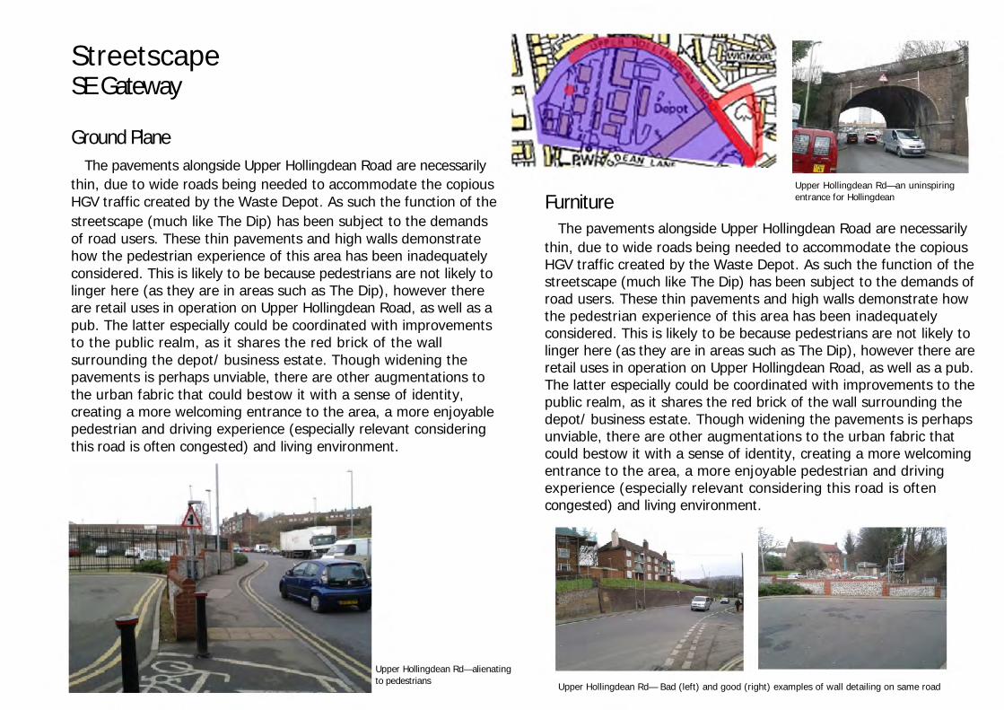
Upper Hollingdean Rd—alienating to pedestrians
Upper Hollingdean Rd— Bad (left) and good (right) examples of wall detailing on same road

Streetscape
SE Gateway Furniture
Vegetation
Davey Drive
Dudeney Lodge & Nettleton Court
Bollards are used to signal that Hollingdean Road does not carry onto Hollingdean Lane (at least for vehicles), and again to signify the pedestrian island by The Hollingbury. These are standard issue, black painted metal double disc-ended bar with a red band around the top disc. While perfectly functional, the appropriateness of the design has not been considered in depth. Two directions could have been taken. Firstly a modern, scratched metal design, perhaps with lighting, to fit in with the modern architecture of the Materials Recovery and Waste Transfer Facility. Secondly a more ornate iron bollard as an homage to the Waste Depot's Victorian heritage.
The streetscape of the SE Gateway has a large portion of greenspace, with trees planted as part of the planning obligations from the development of the Waste Depot to mitigate the visual impact. The greenspace also serves as an interval of development and separate the industrial area of Lower Hollingdean and busy Upper Hollingdean Rd from the heavily residential area of Crestway. There is little scope for this greenspace to play any amenity function, as it is right next to a busy road (even if safety measures were installed there is still the matter of air pollution). A pathway is, however, a thoughtful addition.
Hollingdean Lane (left) and Upper Hollingdean Rd (right) - expedient design and lack of coordination in street furniture There is a rather pathetic single bench at the Dudeney/ Nettleton Blocks. Up a steep flight of steps, the reward is the view of the tower blocks themselves, perhaps the biggest eye sores in Hollingdean. The amenity was no doubt considered a necessity of the development. A relatively simple improvement to the environment here would be to create a more sociable atmosphere, having seating and benches faces each other, rather than at the tower blocks, and perhaps more vegetation to create more of a garden feel.
Dudeney Lodge & Nettleton Court—a courtyard that inade- quately considers the density and diversity of its users, as well as over-estimating the quality of the view. See top right for where the bench should be facing

Urban Design Objective
Criteria Strengths Weaknesses Evaluation (0-5)
Character Distinct sense of place responding to local context
The older Depot buildings and Hollingbury pub provide some sense of history to the streetscape
The heritage of the area is underplayed, and an opportunity to connect streetscape to local history missed. No distinctive streetscape.
1
Continuity & Enclosure
Continuity of frontages and clearly defined public space
The Western wall is consistent, and in material and colour is consistent with the pub.
There is no consistency with other walls, which dominate the SE Gateway. The greenspace at the bottom of Davey Drive is not clearly defined in function.
1
Quality of the Public Realm
Safe, attractive and functional public space
- The fast and prioritised traffic makes crossing Upper Hollingdean Road unsafe. The streetscape (e.g. walls, railings) is dilapidated. The streetscape demonstrates a lack of imagination and effort.
0
Ease of Movement
Accessible, well connected, pedestrian friendly environment
Ped/cycle access from Hollingdean Road to Hollingdean Lane is useful for Depot/ estate workers, Lane residents, and through peds.There is a pedestrian island crossing by the Hollingbury pub.
Other than this, the pedestrian routes are not well connected to Upper Hollingdean or Crestway. More pedestrian island crossings would help to solve this. movement is heavily weighted towards traffic.
1
Legibility Readily understandable, easily navigable environment
The depot and tower blocks serve as potential landmarks for navigation purposes, but only If destination is known in relation to these.
The walls create a blank environment and it’s not clear from the streetscape where you are. More simple signage to indicate the Depot, pub, Crestway, etc needed
1
Adaptability Flexible and adaptable public and private environments
Use of Depot leaves little scope for adaptability, and anchors the industrial estate to current B class use
0
Diversity Varied environment offering a range of uses and experienc
Old and modern Depot buildings makes for an interesting comparison
Dominating industrial and urban character from MRF/WTS, Waste Depot and tower blocks.
1
Urban Design Analysis Tool ‘SE Gateway’ Score – 5/35 Summary Through the size and character of their developments, and the proliferation of (often HGV) traffic, industrial areas often have a dehumanising affect on their surrounding streetscapes. Though there are attempts to stem this, Lower Hollingdean remains much the same. The decorative wall and small amounts of vegetation serve to shield the streetscape somewhat from the Waste Depot, but by lacking any sense of continuity with other walls or street furniture fail to introduce any character in the area and in fact in combination with the wall underneath the flats, and the thin pedestrian access under the dark tunnel, create a claustrophobic urban experience. An opportunity to capitalise on defining an entrance to Hollingdean has been missed.

Streetscape
Crestway A typical mid 20th century suburban development, the streetscape of Crestway is lacking in attempts to accent the streetscape. Nothing stands out from the materials used, vegetation or street furniture gracing the pavements and building frontages, though their degraded condition is noticeable. However, the topography of the area has created necessary adjustments to the streetscape that have the potential for augmentation. One noticeable example of personalisation is a mural at the top of Horton Road, this kind of local modification of the streetscape can increase a sense of ownership of place.
Tavistock Downs
Horton Rd
Stephens Rd—degraded street furniture

Streetscape
Crestway Parade Crestway Parade is situated in the centre of the Crestway character area. Shops and the Unemployed Worker's Centre sit below a storey of flats, and adjacent to Lindfield Court care home and further along St. Joseph's Catholic School. Round the corner is Hollingdean Community Centre. Just as urban decay can be seen as a manifestation of underlying socioeconomic context, so too can the relationship be reversed and a high quality public realm produce value both in use and economic terms. An improvement streetscape here has the potential to reinvigorate the competitiveness of the retail outlets, bring attention to the community services, and provide an attractive environment for all to share (stressing inclusion of elderly and young people) in the heart of Crestway. However, the streetscape is thoughtless and clearly been designed in an expedient way.
Crestway Parade
Furniture Balustrades aiding pedestrian movement up the very steep pavement of Thompson Road are unattractive in the first place, but have also been allowed to fall into a state of disrepair. The threat of this is that mobility impaired residents, especially elderly ones who should have bus passes, might choose to travel further away using public transport, rather than struggle up the slope. Beyond this, it does no favours for the urban quality of the Parade, nor the Tavistock Downs flats. A simple improvement to this balustrade, integrated into improvements to the green space adjacent to it, would greatly increase the ease and enjoyment of walking through Crestway. Thompson
balustrade Rd—unattractive and dysfunctional

Streetscape
Crestway Parade Furniture Because of the topography of the area there are several steps and ramps on the pavement sides. In particular outside Lindfield Court. These have been added in an expedient way, as have the paving. Steps have the potential to add another dimension to the streetscape, which has been lost here. The disrepair in some examples also generates a mistrust of the urban environment in the pedestrian. Bike parking bars have been situated modestly around the hubs of Hollingdean, including The Dip and The Parade. In the instance of the latter, the bar is bent, though no reducing its function particularly. They have not been integrated well into the streetscape, disrupting the ground level components without even
attempts to ameliorate this. The result is incongruity in the urban
Various Crestway locations demonstrate how crumbling material and thoughtlessness can create a mistrust in the urban environment. Uplands Rd (bottom right) demonstrates how to make the pedestrian feel secure.
The Crestway—opportunity for greenspace to mitigate the
Vegetation urban decay and anonymity
The Crestway—deformed bike bar
While the greenspace does have some trees on the Parade side, a more landscaped approach to the space, coordinated between the two patches of grass either side of Thompson Road, perhaps wild flowers lining the pavement (as on Lewes Road in Moulsecoomb) would provide something to look at and signal a change in the nature of the area. This could be coordinated with the Parade with something as simple as hanging baskets of flowering plants or planters outside the shops. The public sign on this bit of greenspace is also conspicuous by its bareness and degradation. There are clearly several community facilities in the area, however the blank sign does nothing but exaggerate a sense of lack of community and civic pride in the area.

Urban Design Objective
Criteria Strengths Weaknesses Evaluation (0-5)
Character Distinct sense of place responding to local context
- No sense of place; area only distinguishable from residential areas by shop fronts. Potential for community engagement missed
0
Continuity & Enclosure
Continuity of frontages and clearly defined public space
- Crestway Parade frontages uncoordinated with frontages of other developments (Lindfield Court, St. Josephs).
0
Quality of the Public Realm
Safe, attractive and functional public space
Space functions to the extent that it provides a few facilities in one place.
Degradation of street furniture and building facades produces an unattractive environment with the perception of a lack of safety.
1
Ease of Movement
Accessible, well connected, pedestrian friendly environment
Steps and ramps demonstrate a consideration of accessibility issues.
Degraded steps and balustrades hinder the ease of movement up and down changes in topography.
2
Legibility Readily understandable, easily navigable environment
Topography of area often aids navigation via views of surrounding urban environment.
Signage or notable landmarks would make the area more adequately navigable.
2
Adaptability Flexible and adaptable public and private environments
There is scope for adaptation on the Parade, with possibly further retail development along the Crestway.
The area would need an integrated upgrade to the streetscape to make it more suitable to other uses.
1
Diversity A varied environment offering a range of uses and experiences
Retail amenity provides brief break in residential character.
Brief and unvaried experience. The basics are there for a more diverse environment (greenspace, retail, community amenity)but no cohesion
1
Urban Design Analysis Tool ‘Crestway Parade’ Score – 7/35 Summary Crestway Parade’s streetscape offers a very transient and fleeting experience. Barely differentiated from the residential surroundings and possessing no enclosure of public space or attempts to form character or coordinate it with its surroundings, it is a missed opportunity to provide an attractive environment for the Crestway community, residents of Lindfield Court, and pupils of the primary school.

Streetscape
Brentwood Rd & Lynchet Cl
Brentwood & Lynchet is a residential area characterised by its proximity to the natural environment North of Hollingdean, namely the Wild Park Local Nature Reserve, Roedale Valley and Lower Roedale allotments, Holingbury and Roedale woods, Holingbury Golf Club and Holingbury Park, some of which reside within the South
Lynchet Close—natural m a t e r i a ls f or s t r e e t
Downs National Park. This is manifested in street views of the neighbouring woods, more vegetation in general, and a sparser and less dominating nature of streetscape which cedes much visual dominance to the nature.
Brentwood Rd—Views of Hollingbury Wood
furni ture identity
carry the
Burstead Close—bulkier developments that still manage to appropriate the nature. Though the appropriateness of further development is questionable (Pioneer House (top)).
Brentwood Crescent—sparser, quieter neighbourhoods

Streetscape
Golf Drive Though all the streets in Brentwood & Lynchet are at least relatively more integrated into/ sensitive of, the natural environment than other parts of Hollingdean (and indeed other Brighton suburbs), none display a better example of this than Golf Drive. Golf Drive and its ancillary developments, The Dyad and The The Diggers, have an understated streetscape that lets the natural environment provide as much of the character and furniture as possible, otherwise using sparse and sensitive furniture that serves its purpose without dominating or cluttering the streetscape.
The Diggers
Golf Drive
The Dyad

Streetscape
Golf Drive
Ground Plane The ground plane uses typical tarmac/asphalt throughout. Pavement is only on the developed side of the road, and as such the Western side of the streetscape gives itself over to Hollingbury Woods, the grass and wooden fence being a nice rural transition. In The Dyad the ground plane has ceded its borders to the grass, as have other parts of the street furniture, such as street lighting. These serve to imbed the streetscape within its natural environment. There are other examples of this across the character area. Threats arising from this are various accessibility issues, e.g. maintenance access to street lighting.
Furniture The balustrade to the steps leading up from Golf Drive to The Dyad is the most visually jarring piece of furniture in the streetscape. The steps themselves, with their simple brownish-grey colour and slight uneven character, blend nicely into the greens and browns of the foliaged slope. Likewise, in The Dyad themselves, a conspicuous highly reflective metal ramp betrays the steps underneath it, which fit nicely into the cosy rural, almost feral, character of the space. These could be improved by the use of more sympathetic materials, e.g. wood, perhaps turfed in places. A threat of the uneven surfacing of the steps, or aspirations of a rustic feel, is an acceptance of unsafe steps. This demonstrates the difficulty of attaining balance in such streetscapes. The use of typical street lighting and signage is a missed opportunity to further consolidate the identity of the neighbourhood.
Golf Drive—typical ground materials... ...are surrendered to nature (The Dyad) Golf Drive/ The Dyad—Jarring material choices
Hollingbury Woods—Choice of material and colour more sensitive to location can make huge changes to stre scape with relatively little effort
Laburnum Grove, Burstead Close Golf Drive

Streetscape
Golf Drive Furniture The gateways to Golf Drive and The Dyad are important components of their streetscape. They immediately inform the observer of what kind of neighbourhood they are entering, and set the tone for the identity of the streetscape. At the gateway to Golf Drive is a flint house which has a rural character that distinguishes itself from the rest of Hollingdean. The gateway to The Dyad is more feral than the rural flint house. The steps ascending into tree and flora-enclosed space feel like an entrance to woodland rather than a neighbourhood and connote a removal from the urban sphere. The pillars by the entrance of 30 Golf Drive also form a unique gateway to the rest of Golf Drive, which, like The Dyad is more secluded. A potential threat to the seclusion and camouflage of the gateways is fooling people that there is no neighbourhood here at all. Of course, that is part of the reason for it's charm, but does raise issues of legibility. Some signage, in appropriate form, would remedy this.
Vegetation The flora of Golf Drive/ The Dyad/ The The Diggers is the streetscapes most distinguishing feature. By keeping furniture to a minimum, allowing vegetation to creep over the streetscape and by using wood for material (e.g. for fencing in The Dyad), the streetscape blends into its environment, ideal for its location by the Wild Park Local Nature Reserve and South Downs National Park. This must be properly maintained however, not just in terms of trimming branches but also cleaning up leaves, so as not to become a threat to safety. Once again, this environment demands a management of balance, which also serves to attach the residents to their
Brentwood Rd
Golf Drive—Rural character Golf Drive—seclusion
The Dyad—What's up the stairs? The Dyad

Streetscape
Urban Design Objective
Criteria Strengths Weaknesses Evaluation (0-5)
Character Distinct sense of place responding to local context
Distinct sense of place derived from an affinity with the local natural environment.
Some street furniture is conspicuously, and jarringly, urban in character.
4
Continuity & Enclosure
Continuity of frontages and clearly defined public space
The frontages on Golf Drive are identical. In The Dyad, they are more individual, with personalised fencing and vegetation, but it is this spontaneity that defines its consistency.
The public space of The Dyad is not particularly clearly defined. The lack of through passage or signage creates a sense of invasion of privacy.
4
Quality of the Public Realm
Safe, attractive and functional public space
The settling into the natural environment makes for a very attractive public space.
Flora growth and litter, and the maintenance of steps do create some safety issues.
3
Ease of Movement
Accessible, well connected, pedestrian friendly environment
Ballustrades aid movement into The Dryad. There is a ramp up to the rest of Golf Drive and The Dyad. The environment is heavily pedestrian friendly
The neighbourhood is somewhat tucked away, and only accessible from one end (Stanmer Villas/ Brentwood Rd). There is maintenance required to some steps in The Dryad.
3
Legibility Readily understandable, easily navigable environment
- It is not clear from Golf Drive that there is residential development further up into The Dyad and The Dyad.
1
Adaptability Flexible and adaptable public and private environments
The light touch of the streetscape means that reconfiguration and personalisation is possible.
There is not much scope for different land uses to be facilitated by the streetscape, e.g. a small office in The Dyad.
2
Diversity A varied environment offering a range of uses and experiences
Though possessing a common theme, the three “units” of the neighbourhood do offer different takes on homes integrated into the natural environment and possess their own charm. They offer residential use and enjoyment of nature. It is also adjacent to other uses (Hollinhbury Woods, Roedale Valley allotments)
Though imbedded in the natural environment, there are no facilities to provide education or further enjoyment of it. There is potential for this, possibly in the property at the bottom of Golf Drive.
3
Urban Design Analysis Tool ‘Golf Drive’ Score – 20/35 Summary The sense of place created by the streetscape of the Golf Drive neighbourhood is removed from that of the rest of Hollingdean. The acceptance of the dominance of the natural environment and minimal attempts to intrude upon it or counter its character make it a pleasant place to experience and bestow upon it a sense of enclosure and tranquillity missing from much residential development, including that of Hollingdean. What is enjoyable about it its surrender to the spontaneity of nature, rather than attempts to organise and conquer it.

Future Potential – The Dip
As a principal retail and community hub, as well as central location, in Hollingdean, The Dip presents itself as an ideal area for upgrades to the public realm. Improving the character and quality here could spread a higher level of urban design across the residential areas adjacent.
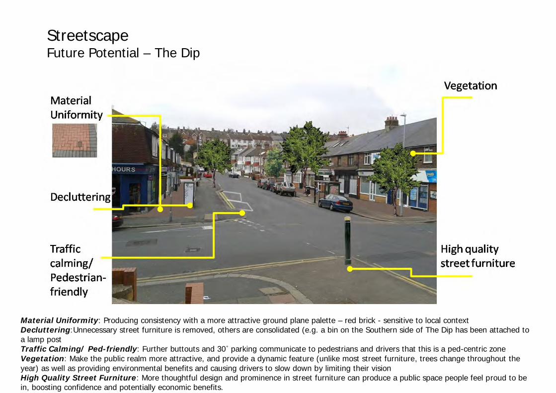
Streetscape Future Potential – The Dip
Material Uniformity: Producing consistency with a more attractive ground plane palette – red brick - sensitive to local context Decluttering:Unnecessary street furniture is removed, others are consolidated (e.g. a bin on the Southern side of The Dip has been attached to a lamp post Traffic Calming/ Ped-friendly: Further buttouts and 30˚ parking communicate to pedestrians and drivers that this is a ped-centric zone Vegetation: Make the public realm more attractive, and provide a dynamic feature (unlike most street furniture, trees change throughout the year) as well as providing environmental benefits and causing drivers to slow down by limiting their vision High Quality Street Furniture: More thoughtful design and prominence in street furniture can produce a public space people feel proud to be in, boosting confidence and potentially economic benefits.

Environment Hollingdean
Groundwater & Geology
All of Hollingdean is within a Groundwater Source Protection Zone (SPZ) (protected by the Environment Agency), though in different zones. Zones are designated based on radius and water travel time from the source.
The entire Hollingdean area is above a Principal Bedrock Aquifer, a solid permeable foundation of chalk that has high permeability, meaning it provides a high level of water storage. It is part of the Seaford Chalk Formation, a sedimentary bedrock formed 84 to 89 million years ago in the Cretaceous period (British Geological Survey, 2012).
A narrow Seconday (undifferentiated) Superficial (drift rock, e.g. sand and gravel) Deposit also runs under the Lower Hollingdean and the Western part of Upper Hollingdean. These deposits were formed up to 2 million years ago in the Quaternary Period (ibid). These are less strategically important than Principal Aquifers, and its undifferentiated status (they are otherwise classed A or B) means that it has different designations in different locations due to the specific local characteristics of the rock type. Either way, it doesn't have more than a local scale of water supply or river base flow capacity.
The significance of the aquifer and its vulnerability is a key planning and development consideration. For example, since Veolia's Mat Recovery Facility and Waste Transfer Station (MRF/WTS) was built on the site of a former abbatoir and obviously bearing in mind the nature of the material the MRF/WTS handles, measures had to be taken to ensure that its construction and use would not compromise the SPZ. These included borehole testing and an integrated drainage system for the plant.

Environment Hollingdean Soilscape Hollingdean has shallow, lime-rich soils over chalk and a freely draining water board suitable for habitats of herb-rich Downland and limestone pastures, limestone pavements and lime-rich woodlands. The soil texture is loamy (National Soil Resources Institute, 2012). The moderately high fertility of the soil is positive since there are several allotments in Hollingdean, including the biggest in Brighton & Hove. However, the chalk character of the soilscape means that water is drained very well, causing issues with growing vegetables at the allotments, this is especially a threat considering the current drought in the South of England.
Hollingdean (NSRI, 2012)
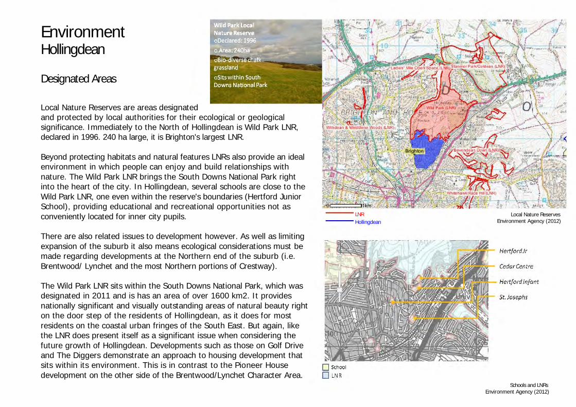
Environment Hollingdean Designated Areas Local Nature Reserves are areas designated and protected by local authorities for their ecological or geological significance. Immediately to the North of Hollingdean is Wild Park LNR, declared in 1996. 240 ha large, it is Brighton's largest LNR. Beyond protecting habitats and natural features LNRs also provide an ideal environment in which people can enjoy and build relationships with nature. The Wild Park LNR brings the South Downs National Park right into the heart of the city. In Hollingdean, several schools are close to the Wild Park LNR, one even within the reserve's boundaries (Hertford Junior School), providing educational and recreational opportunities not as conveniently located for inner city pupils. There are also related issues to development however. As well as limiting expansion of the suburb it also means ecological considerations must be made regarding developments at the Northern end of the suburb (i.e. Brentwood/ Lynchet and the most Northern portions of Crestway). The Wild Park LNR sits within the South Downs National Park, which was designated in 2011 and is has an area of over 1600 km2. It provides nationally significant and visually outstanding areas of natural beauty right on the door step of the residents of Hollingdean, as it does for most residents on the coastal urban fringes of the South East. But again, like the LNR does present itself as a significant issue when considering the future growth of Hollingdean. Developments such as those on Golf Drive and The Diggers demonstrate an approach to housing development that sits within its environment. This is in contrast to the Pioneer House development on the other side of the Brentwood/Lynchet Character Area.
LNR Hollingdean
Local Nature Reserves Environment Agency (2012)
Schools and LNRs Environment Agency (2012)

Environment Hollingdean Designated Areas
The South Downs National Park (left) is vulnerable to threats of development on its doorstep. The Dyad (bottom right) demonstrates how such development can let the nature
environment camouflage and even define its existence. Pioneer House, Burstead Close (top right), however, is a bulky development that though of relatively good quality visual
design relies on its proximity to other developments of its kind in the neighbourhood (Mimosa Court and Laburnum Grove) to justify its approval.

Environment Hollingdean Greenspace The distribution of green amenity in Hollingdean is uneven. By far the most greenspace is in the Brentwood Rd/ Lynchet Cl area, with Hollingdean Park, which also has a playground and is adjacent to Wild Park Local Nature Reserve and the South Downs National Park. In this area there is also the Roedale Valley allotments, over 5 and a half hectares with 216 plots (one of the largest in Brighton & Hove) and Lower Roedale allotments, about 3 and a half hectares with 122 plots. While there are gardens for the flats in Crestway (Horton Rd and Stephens Rd) and various small patches of greenspace throughout Hollingdean (e.g. The Crossway, Tavistock Downs, Davey Drive) the only significant and good quality space is that at the top. The rest of Hollingdean has inadequate amounts of neighbourhood greenspace and where it does exist, it is of poor quality and often inconvenient or unsafe (e.g. the garden at the tower blocks is right next to the buildings, meaning the view is ugly and ball games are dangerous; the greenspace at the bottom of Davey Drive is right next to a busy road (Upper Hollingdean Road)). Upper Hollingdean doesn't have any greenspace, though Blaker's Park is nearby. The Lower Hollingdean tower blocks do have a garden, but it is not big enough considering the density of the blocks. This represents a lack of amenity for the neighbourhood. The greenspace at the top is a good local resource, but the topography of the area make it difficult to access for some. Also, it is not a substitute for a urban greenspace, which children can play on in close proximity to their homes, in a safe neighbourhood environment but without having to be constantly supervised. Gardens (which most residential properties have) and a single park 25 minutes walk from some parts of Hollingdean are not adequate to provide the social and health benefits of open space.
Greenspace in Hollingdean

Environment Hollingdean Flora & Fauna Developments in Upper Hollingdean and Crestway are unlikely to need any sort of ecological assessment. Even the major application of the MRF/WTF in Lower Hollingdean did not have flora and fauna scoped into its Environmental Impact Assessment. Although Veolia didn't find anything of ecological significance when assessing the area (rare or endangered species) bird and bat boxes and a green roof were part of the approved. Similarly, Upper Hollingdean's residential character and lack of much green space at all, mean that it does not have any ecological significance. Various species of bats have been recorded in Brentwood Rd/ Lynchet Cl (including Serotine, Pipistrelle and Greater Horseshoe Bat). All British bats are European Protected Species and they are listed in the Wildlife and Countryside Act 1981. This means it is an offence to intentionally or recklessly destroy or obstruct access to structures being used by bats for shelter or nesting. Thus developments in this area, especially when demolishing existing buildings are potential threats to the ecology of the area (and in danger of breaking the law). Evidence in surrounding area (mammal holes and paths) also suggests the likely habitation of foxes (however, these are of limited conservation interest and do not receive protection under specific legislation (like bats or badgers). Burstead Woods, to the North East of Burstead Close is a Habitat Action Plan woodland, meaning its strategic ecological significance has been recognised. Desktop studies for the Pioneer House planning application ecological survey and assessment (Aspect Ecology, 2009) found several records of birds protected under the Wildlife and Countryside Act 1981, including Great Tits and Blue Tits. Background records of reptiles show presence of Grass Snake, Slow-worm and Common Lizard (ibid). Being heavily residential, there is not likely to be any significant flora or fauna in the Crestway area. However the Eastern border does run alongside a railway line, likely to be a wildlife corridor, especially in the forested section by Crespin Way. This is especially relevant since the line runs North into Wild Park Local Nature Reserve. This corridor is part of the Brighton urban green network, which is recognised as a Biodiversity Opportunity Area, areas prioritised for conservation and restoration as part of the Sussex Biodiversity Action Plan, with opportunities for urban biodiversity, community engagement and possibilities for biodiversity enhancement and management associated with development. The principal threat to ecology is development and activity in the Brentwood Rd/ Lynchet Cl area, due to its location adjacent to a Local Nature Reserve, woodlands, and a golf course.

Environment Hollingdean Flora & Fauna
Eptesicus serotinus (Serotine Bat)
Cyanistes caeruleus (Blue Tit)
Pipistrellus pipistrellus (Pipistrelle Bat)
Vulpes vulpes (Fox)
Burstead Woods (Habitat Action Plan woodland) Wildlife Corridor (Brighton Urban Network)

Environment Hollingdean Threats
Pioneer House, Burstead Close
The biggest environmental threats in Hollingdean are:
• MRF/WTS, where there was a significant air pollution incident
in 2010 (Environment Agency Incident Number 803853)
• The (especially HGV) traffic and rail pass-bys in the area,
evaluated as the most significant source of noise pollution by Terence O'Rourke for the MRF/WTS planning application's Environmental Statement (2006).
• Future developments that could have significant impacts on
the SPZ and/or the ecology in the Brentwood Rd & Lynchet Cl area
Veolia MRF/WTS, Hollingdean Lane
Proposed Preston Barracks development, Lewes Rd
Environmental Statement, Veolia MRF/WTS, Hollingdean Lane Planning Application (2006)

Transport Hollingdean is situated to the north of Brighton, between the A270 (Lewes Road) which links Brighton, Lewes and the south coast beyond, and Ditchling Road, which runs north-south though Brighton, linking Ditchling to the north and running south to The Level and St. Peters Church, which are situated south of Hollingdean. The north of Hollingdean adjoins Hollingbury Golf course and the South Downs National Park. The main vehicle routes within Hollingdean are Upper Hollingdean Road, which links Ditchling Road and the junction with the A270 (Lewes Road) and Bear Road (which links to Brighton Racecourse and the Woodingdean area to the east of Brighton). Important and high trafficked roads in Hollingdean are The Crestway which links Upper Hollingdean Road to the east and north of Hollingdean, and Hollingbury Place which contains the local shopping parade for the area, known locally as ‘The Dip’, and acts as a link route between the east and west of Hollingdean and beyond to the ‘Fiveways’ junction at Hollingbury Road/ Ditchling Road. The only bus route directly serving the Hollingdean area is the no. 50. This bus runs to and from Brighton Station, with key stops at the London Road local shopping centre and the main Brighton shopping district Churchill Square/ Western Road. Within Hollingdean the no. 50 runs a looping one way circuit of the area, starting at the junction of The Crestway, heading north towards Lynchet Close and Brentwood Road from where it heads west, and then returning south to Upper Hollingdean Road via ‘The Dip’. The route runs every 10 minutes, with a loop of Hollingdean (to and from Upper Hollingdean Road) scheduled to take less than 10 minutes, and a further 15 minutes approx. journey time required to arrive at Brighton Station at the end of the route. Moulsecoomb train station is situated to the north-east corner of Hollingdean. The station runs services northwards to the Falmer campus of Brighton and Sussex universities, Lewes and onwards to Seaford, Eastbourne and Hastings on the south coast to the east of Brighton. Southbound trains run to Brighton, with connecting trains running westbound along the coast to Worthing, Littlehampton and beyond, and northwards to Gatwick, London terminals, Ashford international and Bedford. The train station is popular with students travelling to the Lewes Road campuses of Brighton University which are to the east of the station, students travelling to the Falmer campuses, and commuters travelling in both directions- the larger part travelling to Brighton for connecting routes. Locally the station is within walking distance of The Crestway and Brentwood Road/ Lynchet Close area of Hollingdean. London Road station is situated outside of the Hollingdean area, approximately five minutes walk from the junction of Upper Hollingdean Road and Ditchling Road, and is easier to access from the south and west area of Hollingdean than Moulsecoombe Station. This station has northbound, regular stopping, services to London terminals, and southbound links to Brighton for connecting trains. There are no designated cycle routes within Hollingdean. Lewes Road to the east features cycle lanes to Brighton seafront and town centre, and this cycle route joins into the cycle network around The Level to the south.

Primary Vehicle Route
Secondary Vehicle Road
Bus Route
Train Route
Junctions (bigger-busier)
Bus Stops
Main transport routes, junctions and stopping places

Traffic calming at ‘The Dip’
Typical parking in Upper Hollingdean
Hollingbury Road- Busy traffic ‘cut-through’ route
Upper Hollingdean
The Upper Hollingdean area is generally well served by the number 50 bus route, with access also available to routes 26/46 which runs from Ditchling Road into the town centre and to Fiveways. London Road train station is situated 5 minutes walk from the junction of Upper Hollingdean Road and Ditchling Road. Road traffic is high from the Fiveways junction from Ditchling Road/ Preston Drove on to Hollingbury Road; and also from the junction with Upper Hollingdean Road. These routes are particularly high trafficked since the roads are used as cut-throughs to and from Lewes Road/ Bear Road to the east. All junctions on Upper Hollingdean Road are busy as is the junction between Hollingbury Road and Hollingbury Place. These four junctions represent the only access paths for vehicles into the Hollingdean area. The volume of traffic has historically proved problematic, and traffic calming measures have been introduced at ‘The Dip’ and on Hollingbury Road. The area is characterised by terraced housing, and as such there is very little provision for off-street parking. On –street parking is dense, and overflows onto Upper Hollingdean Road. Instances of ‘double parking are not uncommon in the area.
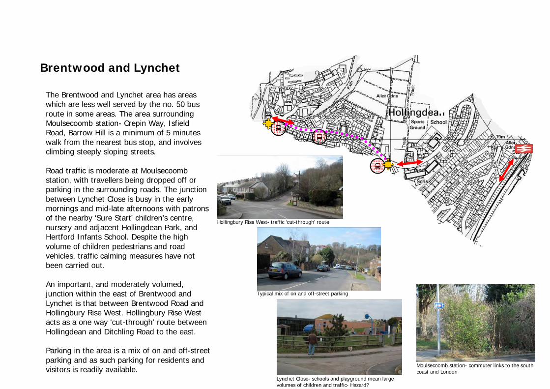
Brentwood and Lynchet
The Brentwood and Lynchet area has areas which are less well served by the no. 50 bus route in some areas. The area surrounding Moulsecoomb station- Crepin Way, Isfield Road, Barrow Hill is a minimum of 5 minutes walk from the nearest bus stop, and involves climbing steeply sloping streets. Road traffic is moderate at Moulsecoomb station, with travellers being dropped off or parking in the surrounding roads. The junction between Lynchet Close is busy in the early mornings and mid-late afternoons with patrons of the nearby ‘Sure Start’ children’s centre, nursery and adjacent Hollingdean Park, and Hertford Infants School. Despite the high volume of children pedestrians and road vehicles, traffic calming measures have not been carried out. An important, and moderately volumed, junction within the east of Brentwood and Lynchet is that between Brentwood Road and Hollingbury Rise West. Hollingbury Rise West acts as a one way ‘cut-through’ route between Hollingdean and Ditchling Road to the east. Parking in the area is a mix of on and off-street parking and as such parking for residents and visitors is readily available.
Hollingbury Rise West- traffic ‘cut-through’ route
Typical mix of on and off-street parking
Moulsecoomb station- commuter links to the south coast and London
Lynchet Close- schools and playground mean large volumes of children and traffic- Hazard?

Lower Hollingdean
Lower Hollingdean is heavily trafficked, being a through route to and from the east of Brighton and beyond, and containing three of the four direct access roads into Hollingdean. The nearest train station is London Road- 5 minutes walk from the junction of Upper Hollingdean Road and Ditchling Road. The area is well served by bus routes 50 and 26/46, which provide a link to London Road shops, Brighton town centre and Brighton Station- with the 26/46 providing access to shops and services at Fiveways. The area contains only two residential buildings- Dudeney Lodge and Nettleton Court, although these are highrise tower blocks. These blocks provide off-street parking within the front forecourt. Elsewhere on Upper Hollingdean Road parking is difficult, with the road acting as an overflow from surrounding streets, free parking for commuters using London Road station (the area immediately surrounding the station is within a controlled parking zone), and parking for workers at the Hollingdean Depot (waste transfer station). The depot itself has access on Upper Hollingdean Road, although associated traffic is staggered throughout the day and does not represent a significant capacity problem to surrounding streets.
Congestion at railway bridge on Upper Hollingdean Road
Heavy vehicle entrance into Hollingdean Depot

Crestway
Typical mix of on and off-street parking
Road widths and on-street parking restricts dual flow of traffic
The Crestway area is moderately trafficked with Davey Drive and The Crestway itself and The Crossway being key routes. Davey Drive/ The Crestway is accessed from Upper Hollingdean Road and is the arterial route for the east of Hollingdean. The Crossway braches off from The Crestway and is an important link route with the shopping parade at ‘The Dip’ and also serves as a vehicle cut through towards Fiveways and Ditchling Road. The area is well served by the no. 50 bus, and the north of the area is in close proximity to Moulsecoomb Station. The area features a mix of on and off-street parking and parking for visitors is readily available. Due to parking restrictions in front of vehicle pavement crossovers which are numerous, parking at a specific destination is not always possible, although provision is usually available within a short walk.
The combination of on-street parking, relatively narrow roads, and The Crestway being on the main bus route means that the dual-flow of traffic is often restricted, and this is the likely source of congestion when it occurs.

Accessibility Hollingdean is served by a single bus route, no. 50, running every 10 minutes from Brighton Station, via Brighton Town Centre and London Road shopping facilities. The route is a one way circuit which provides access within Hollingdean to local facilities, including the shopping parade at Hollingbury Place ‘The Dip’ (post office, convenience store, chemist), Hollingdean Community Centre, Hollingdean ‘Sure Start’ Centre/ nursery, local schools and a G.P. surgery. Facilities at ‘Fiveways’ are accessible from the west of Hollingdean and by the nos. 26/46 bus which runs up Ditchling Road, with a scheduled stop in close proximity to the junction between Upper Hollingdean Road and Ditchling Road. These facilities include shops (food store, post office, chemist), a bank and a dentist. The east of Hollingdean contains Moulsecoomb Station and London Road station is a short walk from the western end of Upper Hollingdean Road. Accessibility to the above services varies, and key barriers to these services and access to public transport modes include the challenges of the location’s topography and factors affecting the ease of pedestrian travel adjacent to and across roads. Accessibility within Hollingdean varies by location, and notably within the studies four character areas. A more in depth investigation, by location is outlined below.


RED ZONE-250m+ from
nearest bus stop
Upper Hollingdean is well connected to the no. 50 bus route, with only a limited area to the northeast being situated more than 250m walking distance from the nearest stop. Bus stops however pose some problems for the less able-bodied. Aside from the stop at ‘The Dip’ and that at the southern end of Roedale Road, local stops do not provide shelter of seating. Further, these stops do not feature raised kerbs to allow for an easy commute onto or off of the bus.
The provision of shops within the dip provides for day to day convenience shopping, but residents would likely be required to leave the area for food shopping in particular. Fiveways is accessible only via a steep hill for pedestrians, again without rest stops, or via two buses- with the need to cross the busy Ditchling Road to access the no. 26/46 bus.
The Dip and the surrounding streets provide many services for day-to-day convenience- Post Office, G.P. surgery, Pharmacy and a small convenience store. Access to the convenience store and post office is stepped, and would be impractical for wheelchair users, or those with mobility problems. Access to The Dip from the east and west is difficult due to the steeply raising slopes to these ends of Hollingbury Place. There is no direct public transport link running east-west on Hollingbury Place, and those wishing to travel to the east and western extremes of Hollingdean would have to travel the full looping route of the no. 50 bus, and/or walk between stops for connecting service. Those wishing to undertake the difficult walk are not provided for in terms of places to stop and rest or take shelter.
Facilities at ‘The Dip’
Stepped access to shops at ‘The Dip’
Benches and shelter needed for rest stops on bus routes and on steep hills
Upper Hollingdean

RED ZONE-250m+ from nearest bus
stop
The Brentwood and Lynchet character area is steeply sloping, descending to the east and west either side of the junction between Lynchet Close and Brentwood Road. The eastern end of Lynchet Close and the roads surrounding Moulsecoomb train station, by virtue of the topography and distance are not well served by the no. 50 bus route. The topography of these less accessible areas also restricts movement to and from parked vehicles. The sloping nature of the area means that parked vehicles are often on significantly different ground level than the pavement, and entrance points to houses is often at a further different level than the pavement. Where pedestrian routes are provided these are stepped and impractical for the less able-bodied. Bus stops in the area provide shelter and seating for travellers which also provide for resting spaces for pedestrians. Access onto the bus is improved for those with sight or mobility impairment by raised kerbs with tactile paving. Similarly designates road crossing points feature dropped kerbs and tactile paving. Moulsecoomb train station represents a barrier for the less able-bodied. The approach to the station is steep, and the access path is narrow and the ground surface irregular and in poor condition. The platforms at the station are linked only by a bridge. Whilst the station provides a link between Hollingdean and Lewes Road (including Brighton University campus) this is not available to those with mobility issues, and the alternative route is not a walkable distance. The main community services are provide in Lynchet Close by the ‘Sure Start’ centre which offers childrens services, a community café, a nursery and Hollingdean playground adjacent. Access to the centre is good with ramped access and the centre has disabled W.C.’s.
Sure Start centre and nearby Hertford Junior School provide location for range of children’s and community groups with good access
Station bridge represents a barrier for the less able-bodied
Bus stops with raised kerbs, shelter and benches
Restrictive access to Moulsecoomb station
Brentwood and Lynchet

Sainsburys, Lewes Road 5-8 minutes walk
The Lower Hollingdean area has only two residential buildings, Dudeney Lodge and Nettleton Lodge. Parking is offered within the forecourt of these buildings and access to the buildings for residents is good, with level access and lifts to all floors. The area is well served by bus routes 26/46 which run on Ditchling Road and provide access to the facilities at ‘Fiveways’. Access to ‘The Dip’ by bus would meaning travelling the full loop of Hollingdean, via The Crestway and Brentwood Road. Train access is via London Road station which is approximately 5 minutes walk from the junction of Ditchling Road and Upper Hollingdean Road. Direct public transport is not available to this station, and parking in the surrounding streets is difficult due to the designation of the majority of parking space for residents within this Controlled Parking Zone. Access via foot is steep via Ditchling Rise where ramped access is provided. Access via Springfield Road is stepped. A newsagent is available on the north side of Upper Hollingdean Road adjacent the junction with Ditchling Road, although the busy road a dense on-street parking make crossing the road a hazard for pedestrians. Inspite of the heavy traffic. Calming measures have not been implemented as they have in nearby Hollingbury Road. Further, there are few pedestrian crossing places designated on Upper Hollingdean Road. Sainsburys supermarket to the east on Lewes Road is a 5-8 minute walk, although there is no direct bus route. The area has few community facilities in addition to those within Hollingdean. The area does contain the only Public House, however, The Hollingbury at the junction of Upper Hollingdean Road and Roedale Road.
Dense on-street parking
Lower Hollingdean


RED ZONE-250m+ from nearest bus
stop
The Crossway- steep pedestrian link with ‘The Dip’
Bus stops with stepped access to buses and no seating/ shelter
Poor access to community Centre itself
Bus stop serving Hollingdean Community Centre
The Crestway character area is well served by regular bus stops on Davey Drive and The Crestway. Only a limited area incorporating part of Horton Road and Tintern Close to the west are more than 250m from a bus stop. Bus stops on Davey Drive have poor access to buses by virtue of the topography of the area. Davey Drive/ The Crestway rises not only south- north but also east- west and as such the grass verges on the western side of the road are sloped, with stepped descent only at bus stops. Further, many bus stops on Davey Drive/ The Crestway do not provide shelter or seating for passengers or pedestrians using this route. The main destination within The Crestway is towards Crestway Parade which houses a local convenience store, and Hollingdean Community Centre on Thompson Road which is served by the same bus stop. The bus stop offers good access onto and from buses, incorporating a raised kerb with tactile paving, shelter/seating and ramped access. In contrast to the good accessibility of the bus stop is the accessibility of the Community Centre itself. The approach is steeply sloping, and although there are dropped kerbs, the pavement is very narrow. There is no designated parking for the community centre, and there is no provision of seating for those waiting for a taxi. Access into the centre is poor, with damaged irregular ground treatment to the access path. Internally the accessible toilet is too small for a wheelchair, and the internal door layout means that access to the kitchen is via a tight corner which is not appropriate for a wheelchair user. The bus route provides access to facilities at ‘The Dip’. The pedestrian link to The Dip is via The Crossway. This route, again, is steep and there is no provision for resting en route.
The Crestway

Proposal 1: ‘The Dip’ Shared Space, benches and ramps Future Transport and Accessibility Proposal
‘The Dip’- locally viewed as a traffic hazard despite traffic calming measures
Despite traffic calming measures, and falling reported traffic accidents ‘The Dip’ is viewed as a hazard by local residents- in March 2011 a petition signed by 835 local residents was submitted to Brighton and Hove City Council, although to date improvement works have not been forthcoming. New Road in Brighton town centre has recently been transformed by a ‘shared-space’ system. Through uniform paving and the blurring of the divide between vehicle and pedestrian spaces, road users are naturally more cautious when travelling through such a space. At The Dip the proposal is to replicate the scheme, although due to the residential nature of the area to demarcate between pedestrian and vehicle areas with bollards, or planting carefully selected not to conceal pedestrians wishing to cross the road. Parking provision would be removed.
New ramps would be introduced to the Post Office and convenience store to aid those with mobility issues. Benches would be introduced at and on the steep approaches to the east and west to encourage walking to the centre by providing resting and meeting spaces.

Proposal 2: Hollingdean Community Centre Improved access and Layout Future Transport and Accessibility Proposal
As previously covered, the Hollingdean Community Centre is well served by ramped bus stop on The Crestway, although access to the centre itself is down a narrow path on a steep hill. The entrance path is in poor condition. The entrance door is heavy, and within the building the disabled W.C. is to small and access to the kitchen involves a tight corner, without turning space for a wheelchair. Those wishing to travel by taxi do not have outside seating when waiting, and disabled patrons do not have designated parking. It is proposed that the access route from The Crestway is widened and re-laid, and the entrance path to the centre similarly improved. A disable parking bay would be provided at the front of the centre, as would a bench for resting/ waiting. The centre itself would be reconfigured to provide for a larger disabled toilet, and improved access to the kitchen. The main entrance door would be replaced/ upgraded to incorporate an assisted opening mechanism.
New bench- an opportunity to provide visual interest in the area.

Proposal 3: Moulsecoomb Station Improved access Future Transport and Accessibility Proposal
Widen and re-lay approach path for improved accessibility
Remove barriers
The barrier within the station- the bridge between platforms- is unlikely to be improved upon. Access to the north/east bound train service however could be improved through the provision of a disabled parking bay in close proximity to the station on Crespin Way. It is proposed that the access path be widened over part of the grassed area which currently flanks it. The existing barriers (above) shall be removed to improve access. As a safety measure cyclists shall be instructed to dismount well in advance of the entrance point.

EDUCATION
1. List of stakeholders.
Nursery or Infants School
- Cherry Tree Nursery, Sure Start Centre, Brentwood
Road, Brighton BN1 7DY
- Hertford Nursery and Infant School, Hertford Road,
Brighton, BN1 7GF
- Downs Infants School, Ditchling Road, Brighton, BN1
6JA
- Butterfly Bays Children’s Nursery, Ditchling
Road, Brighton BN1 6JL
Junior School:
- Downs Junior School, Rugby Road, BN1 6ED
- Hertford Junior School, Lynchet Close, BN1 7FP
Learning Support Services:
- Learning Support Service, Florence Place, BN1 7GU
- The Cedar Centre,Lynchet Close, BN1 7FP
- Alternative Centre For Education, Queensdown School
Road Off Lewes Road, BN1 7LA
Primary School:
- St Joseph’s Catholic School (Promary School), Dave
Drive, BN1 7BF

Figure 1. Percentage of the educational facilities within the Hollingdean area (authors’ research).
In terms of the educational profile, Hollingdean as a typical residential area mainly consists of the early-education courses and
the adult education is limited. There are four Nursery/ Infants schools, two Junior Schools, one Primary School and three
Education Support Services within area of the research, including western boarder- Ditchling Road. Some adult learning courses
are offered by local community services; however external schools (e.g. University of Brighton or Brighton City College) play
crucial role in mature residents schooling and over 60% of adults (males and females) hold at least Level 1 degree (Figure 2).

Figure 2. Qualification by gender- Males and Females aged 16-74 (Census 2001).

Also, almost 60% of the Hollingdean population is aged between 0 and 29 (Figure 3).
Figure 3. Total population by age (Census 2001).
The choice of several early-education schools and short-walking distance to those places may encourage young parents to settle
down in this area. It is noticeable that few schools appeared within Brentwood and Lynchet part of Hollingdean and there are
relatively new buildings as, for instance, Sure Start Centre has been founded less than seven years ago. To explain that, it has to be
highlighted the fact that there is a written law provision to arrange a new educational institution and that is at least 3-5 ha available
land for early-stage education sites, and even more for higher than Primary School establishments. Other parts of this area are
highly occupied and there is no available ground for future investments so only north part can be considered, although neighbouring
the South Downs National Park can acts as a barrier for any future investigations

STRENGHTS WEAKNESSES OPPORTUNITIES THREATS (SWOT) ANALYSE: Strengths:
- Mainly appropriate for residential demands (young parents and a high level of the early-year education students)
- A choice of several schools within a short walking distance
- Most of the educational facilities are relatively new
Weaknesses:
- Only early-year education facilities (may cause other groups out-migration)
- Eastern part of Hollingdean contains only one school
- Limited land availability for further education facilities
Opportunities:
- Facilities structure may encourage young parents to settle down in Hollingdean
- High level of children and young parents population may increase further investments within a particular educational sector
- Competing facilities might increase the quality of available services to encourage potential customers
Threats:
- Uniformity of educational may increase the level of the competitiveness between those places
- Lack of the ground under further investments as a result of the high residential buildings density and neighbouring green
spaces (parks and the South Down National Park)
- Undiversified educational facilities network may discourage other social groups to live within the Hollingdean neighbourhood

COMMUNITY SERVICES
1. List of stakeholders.
Church or Chapel:
- St Matthias C Of E Church, 45 Hollingbury Park Avenue, BN1 7JQ
- Chapel of The Holly Family, Hollingdean Street, BN1 7GQ
- St Richard’s Church, Beal Cresent, BN1 7BU
- City Gate @ The Dip, 119d Hollingdean Terrace, BN1 7HB
Community Centres:

- Hollingdean Community Centre, Thomson Road, BN1 7BH
- Sure Start Children’s Centre, Brentwood Road, BN1 7DY
Sport Facilities:
- Hollingbury Park Bowls Club, Tennis Courts, Ditchling Road, BN1
- Hollingbury Golf Course, Ditchling Road, BN1
- Hollingdean Park (Skatepark, Football Pitch), Lynchet Close, BN1 7DY
Pubs:
- Hollingbury Pub, 1 Roedale Road,BN1 7GB
- Stanmer Pub, 292 Ditchling Road, BN1 6JG
- Tamplin’s Ale House, 176 Ditchling Road, , BN1 6JA
Allotment or Community Garden:
- Roedale Allotments and Garden Society, Lower Roedale and Roedale Valley
- The Moulsecoomb Forest Garden and Wildlife Project at the north end of Crespin Road
- Historical Jewish cemetery, Florence Place, BN1 7GU

Figure 4. Percentage of the community facilities within the Hollingdean area (authors’ research).
Hollingdean offers a variety of community services where local residents can be actively involved in available projects and
activities. Within area of the research including Ditchling Road on the west side, there are four Christian Church institutions, two
community centres, four sport facilities, one historical Jewish cemetery, three parts of the local allotments and gardens and three
pubs that play some role in local community.
Despite of the fact that residential churches offer typical Sunday’s services, people can also take participation in several activities
organized in those places as, for example, yoga, drama classes or aerobic. It has to be underlined that this area only contains
Christian churches and Christians create over 60% of the whole Hollingdean’s population (Figure 5).

Figure 5. Hollingdean’s religion profile (Census 2001).
It has to be also remained the fact that there is only one cemetery by Florence Place, and that is a historical Jewish cemetery that
attracts some tourists arriving to Brighton (Picture 1).

Picture 1. The Historical Jewish cemetery, Florence Place (Photo: author).
Local community centres have a wide range of activities where most of those classes are free of charge. Hollingdean Children's
Centre (Picture 2) offers services for families with children under five to all areas of Hollingdean, Preston Park/Preston area,
Hollingbury and Patcham, Withdean, Westdene and Tongdean There is also a community café allocated inside the Sure Start
Centre and this place is open for public use as well. There is noticeable lack of public toilets within Hollingdean neighbourhood
what may discouraged elderly people to walking so in some cases, Community Café act as a public toilet facility.
Picture 2. The Hollingdean SureStart Centre (Photo: author).
The main community centre called the Hollingdean Community Centre (Picture 3) is managed by charity organization, the
Hollingdean Development Trust. This place is addressing issued to poverty, deprivation, education or trainings, to provide sport

facilities, and to provide or assist in the provision of public health or childcare services within the Hollingdean. This centre is self-
founded and financial activity is described in figure 6.
Picture 3. The Hollingdean Community Centre (Photo: author).

(Previous page)Figure 6. The Hollingdean Community Centre’s previous financial activity (www.cafonline.org).
There are several projects supported by the Hollingdean Community Centre, and one of the latest initiatives encourages
community members to plant green roofs on the disused bin sheds. This project involves local residents that can provide a help in
planting and creating more roofs partially or completely covered with vegetation over a waterproof membrane. There are several
advantages of those constructions as, for instance, providing insulation or creating a habitat for wildlife. Another eco-friendly
project called ‘Free Home Energy Survey’ has been announced recently and offers free energy survey and home report worth £395
each for first 50 residents from Hollingdean and Hanover area who will sign up.
Local resident can also express their feels and raise some ideas to improve local quality of life or decrease social anti-behaviour by
being a part of the Local Action Team (LAT). The LAT is fully supported and managed by the Hollingdean Community Centre.
Regular meetings involve attendance of The Police Community Support Officers, the Community Warden and the Community
Development Workers or Officers from Brighton & Hove City Council that discuss certain issues with community.
There are only two sport facilities within area of the research (Hollingdean Park and local skatepark) and both of those complexes
are open for public use. Both of those places are allocated on North-East boarder of Brentwood and Lynchet. The Hollingdean Park
is open for public and consists of large playground and football pitch on the top. The Hollingdean’s skatepark is allocated close to
the Hollingdean Children’s Centre on Lynchet Close and is completely separated from the main play park. It is not visible from the
main road, has been vandalised recently and skatepark users feel unsafe. All those issues raise a proposal of the skatepark
relocation. After several consolations (mainly with skaters), the preferred site is just below the football pitch in the main park.
After two public meetings with local skaters and the local community, a new skatepark design has been finally produced. A 3D
model (Figure 7) is available on the Hollingdean Community Centre website and a new construction will consists of concrete
comprising bowl and plaza. This project will cost £74,999 and the money has come from a variety of sources. The skatepark
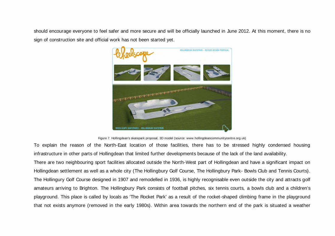
should encourage everyone to feel safer and more secure and will be officially launched in June 2012. At this moment, there is no
sign of construction site and official work has not been started yet.
Figure 7. Hollingdean’s skatepark proposal, 3D model (source: www.hollingdeancommunitycentre.org.uk)
To explain the reason of the North-East location of those facilities, there has to be stressed highly condensed housing
infrastructure in other parts of Hollingdean that limited further developments because of the lack of the land availability.
There are two neighbouring sport facilities allocated outside the North-West part of Hollingdean and have a significant impact on
Hollingdean settlement as well as a whole city (The Hollingbury Golf Course, The Hollingbury Park- Bowls Club and Tennis Courts).
The Hollingury Golf Course designed in 1907 and remodelled in 1936, is highly recognisable even outside the city and attracts golf
amateurs arriving to Brighton. The Hollingbury Park consists of football pitches, six tennis courts, a bowls club and a children’s
playground. This place is called by locals as ‘The Rocket Park’ as a result of the rocket-shaped climbing frame in the playground
that not exists anymore (removed in the early 1980s). Within area towards the northern end of the park is situated a weather
station and underground reservoir. This park offers views over the city to the English Channel and an area of woodland planted in
the nineteenth century is regularly visited by locals.
Hollingdean’s allotments and garden areas are one of the main centres of the community life. Two sites, the Lower Roedale and
Roedale Valley are mainly managed by allotment holders that create a federation called the ‘Roedale Allotments and Gardens
Society (RAGS)’. The RAGS encourage, for instance, volunteering and helps to improve those sites. This federation has own
committee that meets monthly to discuss variety of issues, as for example, site security, tree cutting, mentoring scheme or
planting. Another allotments’ site is located outside the Hollingdean boundaries in the north end of Crespin Road. The
Moulsecoomb Forest Garden and Wildlife Project is a community food initiative allocated on 9 plots at the Moulsecoomb Place
allotment site. This place is open to everyone two days a week and provides a variety of educational, work skills and social
opportunities to all residents and people who want to participate in this programme. The Moulsecoomb Forest Garden and Wildlife
Project also carry out work in the woods outside the project followed by management plan in co-operation with the South Downs
National Park. The aims of this movement are, for example, to reduce anti-social behaviour, to offer free organic food, to improve
community health, to enhance skills and employability by offering trainings or volunteering opportunities.
It has to be added that local pubs can play a secondary role in community life where people are gathering and have a chance to
meet other residents. There is only one Pub in Hollingdean paradoxically called the ‘Hollingbury Pub’ and two other taverns are
allocated by Ditchling Road.
In overall, available community services have wide range activities to offer local residents (Figure 8). Nevertheless, most of those
classes are pre-dominated by sessions mainly dedicated to young parents or children. Elderly people may suffer from the lack of
activities dedicated to them; however according to Brighton and Hove’s ‘Active for Life’ programme, there will be weekly sessions
for 50+adults starting in Spring 2012. Local community centres are situated in hardly accessible north part of Hollingdean because

of this area topography that can discourage some people with walking difficulties. Those sites are allocated far away from other
parts of Hollingdean, although different activities can be found in alternative places, e.g. community churches or sport facilities.
Figure 8. Weekly activities in Hollingdean (authors’ research).

EXAMPLE OF FUTURE PROPOSALS: 1. The wide network of out-door benches.
a. People could admire some local views
b. Elderly people could use them as a rest/ chill out point within areas of the unfriendly topography (hills)
Source: Google Images
2. Local market.
a. Place where people could co-operate on the regular base
b. ‘The dip’ as a suggested location
c. Local market could co-operate with local allotment and garden societies

Source: Google Images
3. Transformation of existing buildings (e.g. disused, abandoned properties) for different social purpose that could resolve the
problem of the lack of the free ground for new investments.
Source: Google Images
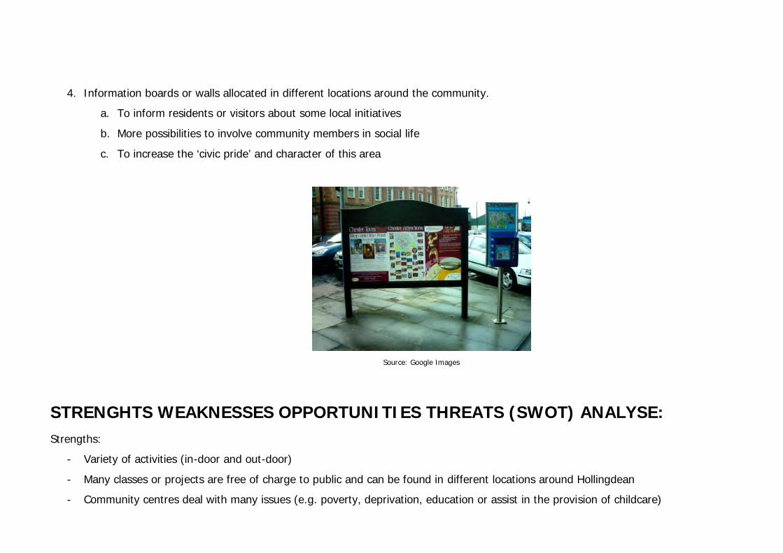
4. Information boards or walls allocated in different locations around the community.
a. To inform residents or visitors about some local initiatives
b. More possibilities to involve community members in social life
c. To increase the ‘civic pride’ and character of this area
Source: Google Images
STRENGHTS WEAKNESSES OPPORTUNITIES THREATS (SWOT) ANALYSE: Strengths:
- Variety of activities (in-door and out-door)
- Many classes or projects are free of charge to public and can be found in different locations around Hollingdean
- Community centres deal with many issues (e.g. poverty, deprivation, education or assist in the provision of childcare)

- Some local initiatives offer variety of educational, work skills and volunteering opportunities
Weaknesses:
- Limited access to some facilities (e.g. unwelcoming topography or lack of the public toilets accessibility)
- Community centres are not big enough and most of the available activities are dedicated to the certain demographic groups
(young parents or children)
- There is a need for further street furniture (benches or sign posts)
- The main community centre is self-founded
Opportunities:
- Great outdoor opportunities, e.g. for dog owners (local parks and the South Down National Park)
- Some of the available services can encourage external authorities for further investments within this area in context of the
economy or tourism
- Local federations or community groups can increase the feel-good factor and social affiliation in this area
Threats:
- The lack of the social diversity may affect the choice of available activities and make them dull or unattractive for other groups
- The low level of elderly people in this area may excluded them from the participation in social activities
- Limited land for possible investments in the future (high density of the building infrastructure and neighbouring green spaces
under protection; however there may be solution in transforming existing buildings)

Housing and Architecture Upper Hollingdean
The borough of Hollingdean first developed at the beginning of the 20th century. The area lies in the northern zone of Brighton and offers a characteristic topography. Settlement began in the lower part around 1910 when long clusters of terraced housing were realised. The very first settlements in the surrounding were farming estates. Their presence on older town maps gives some insight of their age, Harrington Farm figures on a map of 1885. Another settlement was theRoedale Farm, one of the main longitudinal axis in the early developed area of Upper Hollingdean is called Roedale Road. Starting the urbanisation in the southern and western parts of Upper Hollingdean, the area grew gradually during the 1930's till the whole valley was covered. The lower area is almost exclusively covered by terraced housing showing partially Victorian and Edwardian style elements amongst others. The houses are both gable-end and side-gabled onto the streets due to their respective design and orientation of the ridged roofs. The terraced houses shown were erected with bricks, dressed stones and even a few half-timbered structures stand in the north-western angle. Some houses have a cladding with weather-boards even if the lower area is far less exposed to the wind and weather conditions as the places on top of Hollingdean. The majority of the terraced houses are privately owned, few are used as students flats and others are currently unoccupied. Aside the arrays of terraced housing of the early 20th
century, the area of the Dip as the economic core of Hollingdean shows a mixed-used housing scheme which is less old than the surrounding terraces.
Roedale Road
On the fringe of the shopping strip, a certain number of detached houses have been built, they are probably related to a later development of this area. There is only one site where a residential block and some adjacent terraces have been realised recently. The major part of the older housing show rather pleasant examples of care by the dwellers. Further the oldest part of Hollingdean hides a small Roman-catholic “Chapel of the Holy Family” in a byroad called Hollingdean Street. The entrance shows a classicist frontage, the building's cladding does not have any other distinctive features. It's location is exceptional as it fits barely in a space limited by the backyards of the adjacent terraces on both sides.
Stanmer Villas
Section: Stanmer

After World War II, a second phase of settlement began in the 1950's and 60's in the elevated areas east of the valley. The buildings are generally blocks of flats with 3 stories. The brick-built blocks are staggered in groups along ring roads which follow the contour lines of the topography. The building's design is functional and mostly identical without any distinctive traits. There are also some terraced housing layouts added at a later date along the major access roads. The blocks of flats are governed by the council, they constitute the poorest area of Hollingdean. The lack of plants and trees is a significant feature which appears in many locations. The residential blocks are surrounded by vast lawn surfaces and the streets offer just the basic street furniture.
In a central location of this ward, there is the Anglican St. Richard church settled on a hemispheric lot within the Beal Crescent. The brick-built structure shows a functional design on a classic cross-shaped footprint with an abside to the North-east. There is no tower attached, but its distinction is merely due to its large open lawn surfaces which surround it. Despite the fabulous views over the Lewes Road corridor and the opposite residential boroughs of Brighton, there is generally a stern atmosphere when walking through the streets. The pavement and the alleys are often in a miserable state, the bus shelters have been subject to vandalism and there is litter spread in public areas. Bulky waste accumulates in the private frontyards of certain terraced houses in this area and gardening is neglected by some residents.
The Crestway, council houses
Brentwood Road
The Linkway
The Crestway
The Crossway
Davey Drive

Section: Upper Hollingdean Road
The top part of Hollingdean was the latest to be developed. The area spreads from the north-western edge along to the eastern border which touches the railway line and Moulsecoomb station. The main roads are Brentwood Road and Lynchet Close. There is quite adistinctive character associated with both streets. Brentwood Road touches an area with terraced houses and housing estates that were built in the 1970's and 80's. There is sheltered housing available, the area is well maintained and lies in a slope that connects the elevated plain to the East with the terraced housing estates to the West.
Lynchet Close offers some facilities dedicated for the younger generations such as the 'Sure Start' Community Centre, adjacent is the playground and skate area in Hollingdean Park. Further there are two schools for infants and juniors located in Lynchet Close. The local housing consists mainly of brick-built terraced housing, semi-detached constructions and bungalows. Most of the housing are privately owned, the houses are provided with a front-garden and a driveway which leads to the garage and the entrance. The traffic congestion is quite high next to the school facilities, the surrounding areas are set in a quiet environment, most of the streets on the east edge have got a dead end. Section: Uplands Road
Brentwood and Lynchet

Residential buildings Dudeney Lodge & Nettleton Court
Depot: view from Davey Drive
Upper Hollingdean Road
Lower Hollingdean is a mixed-use area which is enclosed by the Upper Hollingdean Road. The Hollingdean Depot and its waste recycling facility is located in the lowest part, hence it is overlooked by the residents who live further uphill. Some of the main arterial roads throughout Hollingdean lead to the depot site which is the entrance gate towards the town centre. Further the depot was used as a slaughterhouse, in the actual context the site is still delimited by a high brick wall. Aside the recycling facilities are the two distinctive residential tower blocks which are by far the highest structures in the surrounding. They feature either as an entrance gate to the inner city and they designate the changeover from the mixed-use urban pattern to the rather suburban residential surrounding. Lower Hollingdean does not feel to be an integral part of the Hollingdean borough because it is cut by the highly congested Upper Hollingdean Road which constitutes a main link between the eastern and the western boroughs of Brighton. The few shops located along the road seem rather to be focussed on the passing traffic than on the local community.
Lower Hollingdean
Upper Hollingdean Road
Upper Hollingdean Road towards Lewes Road
Section: Upper Hollingdean Rd

Upper Hollingdean Road
Brentwood Rd – Lynchet Close Arranging a local square next to the communty centre. The array of trees to the right delimits the greenspace from the street.
Beal Crescent St Richard church is framed by trees in a symmetric order. The layout accentuates the Beal Crescent. The road surface is redesigned with a distinctive pavement which runs along the church.
The Dip – Hollingbury Place Trees (or alternatively: bollards) arranged on both sides underline the axis of the road that connects the lower with the upper part. The new pavement layout forms a spatial entity with the terrace structure.
Proposals Future urban measures

Proposals part II Future urban measures
Character / Identity The blocks show all the same functional design. They do not feature any distinctive architectural elements. One additional glass-panelled frontage aligned with the main entrance would accentuate the identity of the buildings. They could be provided in diverse colour schemes to add a characteristic note, further the large surface of the gables allow to realise artistic mural paintings on every object. Some streets in Upper Hollingdean feature old 'Art Nouveau' light posts. Hence could an original design of light posts be dedicated to every area related to their period of development ( i.e.1960's, 70's, 80's...).
' Feel good factor ' The wide open green spaces between the blocks which are characteristic for the Crestway area do not offer any privacy to the residents. The planting of trees enables to create a visual barrier between the road and the buildings. The trees can be arranged dependant on the topography and the orientation of the blocks.

Retail & Economy
Despite the diversity of businesses within the borough, the local retail seems to be attended exclusively by locals for convenience matters. The present stores along Lewes Road and in the Hollingbury Industrial Estate are a big if not an intangible market challenger for the local businesses.
Despite the four distinctive areas which are significant for their original development, the local shops mostly concentrate along the main access road to Hollingdean which is The Dip / Hollingbury Place area. There are some shopping facilities grouped along The Dip. These are take-aways, convenience stores, a barber shop, a pharmacy, a post office, a betting agency and a café. The shops lie along the sole bus route n°50 which connects Hollingdean to Brighton town centre. Nonetheless there are a few retail shops settled in a small block along The Crestway which is dedicated to the close surrounding area and also lies on the bus route n°50. In Roedale Road there is a small car repair service established in a former garage in between the terraced houses. In a parallel running road called Hollingdean Terrace a space was created for people who need a venue or a workshop for artistic activities. This is the only location within the borough that offers the service which might be an interesting scheme to be established in various forms by the local community. In the Community Centre in Lynchet Close a café features among the facilities which are offered to the residents and visitors.

Health and Wellbeing The World Health Organisation defines Health as ‘a state of complete physical, mental and social wellbeing and not merely the absence
of disease or infirmity.’ This piece of the report will use this definition as a starting point to analyse Hollingdean as a whole, and as the
four separate character areas which have been outlined previously. Briefly touching on health provision within the area but further
explored elsewhere in this report, this section is more concerned with the current issues in Hollingdean both positive and negative
which affect the residents wellbeing.
Taking Census data from 2001 is not necessarily indicative of Hollingdean as it is now, but can provide an insight into long term health
problems and the provision of healthcare. With this is mind, the 2001 Census asked people to describe their health, over the preceding
12 months as 'good', 'fairly good' or 'not good'. The results as seen in the table below show that the majority of residents describe
themselves in good health, but in terms of Brighton and national averages fall short.
Hollingdean Brighton and Hove
England and Wales
Good 66.5 68 68.6 Fairly Good
24.2 22.9 22.2
Not Good 9.2 9 9.2 The Census also asked questions about any limiting long-term illness, health problem or disability which limited peoples daily activities
or the work they could do. This is shown in the figure below, and highlights that almost 1 in 5 people suffer from a long term illness
which impacts on their life.
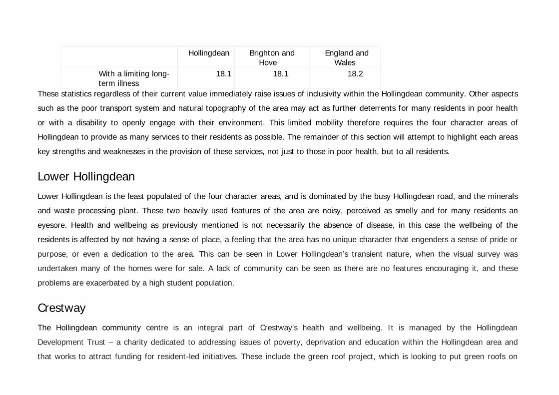
Hollingdean Brighton and Hove
England and Wales
With a limiting long-term illness
18.1 18.1 18.2
These statistics regardless of their current value immediately raise issues of inclusivity within the Hollingdean community. Other aspects
such as the poor transport system and natural topography of the area may act as further deterrents for many residents in poor health
or with a disability to openly engage with their environment. This limited mobility therefore requires the four character areas of
Hollingdean to provide as many services to their residents as possible. The remainder of this section will attempt to highlight each areas
key strengths and weaknesses in the provision of these services, not just to those in poor health, but to all residents.
Lower Hollingdean Lower Hollingdean is the least populated of the four character areas, and is dominated by the busy Hollingdean road, and the minerals
and waste processing plant. These two heavily used features of the area are noisy, perceived as smelly and for many residents an
eyesore. Health and wellbeing as previously mentioned is not necessarily the absence of disease, in this case the wellbeing of the
residents is affected by not having a sense of place, a feeling that the area has no unique character that engenders a sense of pride or
purpose, or even a dedication to the area. This can be seen in Lower Hollingdean’s transient nature, when the visual survey was
undertaken many of the homes were for sale. A lack of community can be seen as there are no features encouraging it, and these
problems are exacerbated by a high student population.
Crestway The Hollingdean community centre is an integral part of Crestway’s health and wellbeing. It is managed by the Hollingdean
Development Trust – a charity dedicated to addressing issues of poverty, deprivation and education within the Hollingdean area and
that works to attract funding for resident-led initiatives. These include the green roof project, which is looking to put green roofs on

disused bin sheds throughout the area. This attempt to brighten the locale, and encourage wildlife is a significant step towards
improving wellbeing, as utilising the natural environment in this area of low density housing will stimulate the neighbourhood to use the
open space available to them, and may inspire them to venture to the South Downs National Park. The community centre itself acts as
a hub for Crestway and the Hollingdean community, providing child friendly services and classes throughout the week, and also hosting
several multicultural classes, such as the Chinese parent and toddler group.
Crestway is one of the more permeable areas of Hollingdean, and this feeling that everywhere else is walkable helps to alleviate the
sense of enclosure which can affect housing estates such as this one. From the projects put forward by the community centre it can be
seen that they are trying to produce a feeling of sensory variety, and personal control over environmental conditions, instilling a sense
of pride and ownership. These initiatives designed to enhanced wellbeing will therefore have positive impacts on the community.
Upper Hollingdean Upper Hollingdean itself consists of two parts. The houses facing onto Ditchling road which act as the boundary for the Hollingdean
area, and everything else in between them and the other three boundary areas. The houses on ditchling road are juxtaposed with the
houses within upper hollingdean. Still terraced and built in the same time period, but the level of care taken in the maintenance of
these homes is completely different. The two areas within Upper Hollingdean themselves are almost separate communities and there is
no cohesion between the two. The lack of community cohesion, and intense privacy suggests a disinterested and potentially ‘just
passing through’ attitude of the residents in this area. This can be seen by the lack of care taking in the few green spaces available at
the front of residents homes, and the disrepair the homes themselves are in.
Upper hollingdean from the visual survey has very limited visible outlets for exercise both indoor and out. There is a distinct lack of a
connection to nature, with the green spaces provided in disrepair and some being used for fly tipping. These are important factors
when considering an areas health and wellbeing and so evidently need to be addressed. Undertaking the visual survey there is a sense

of privacy within the area, but this is almost too private. Ground floor windows are closed with the curtains drawn, and there is no
feeling of community in this area. Feeling trapped in their own homes undoubtedly has a detrimental effect on occupants wellbeing.
Arguably the most central of the four character areas, Upper Hollingdean should have the most to offer, with The Dip shopping parade
acting as a focal point for the community to interact. In reality this is plainly not true, as many of the shops are uninhabited and the
traffic do very little to promote a welcoming sense of place. The Community office is based in this area and is a visual presence but
despite this presence, what effect they have on the surrounding area remains to be seen. Being the more central of the four areas
there is good access to a surgery and a pharmacy, but very little additional services.
Brentwood and Lynchet Brentwood and Lynchet has perhaps the greatest sense of community ownership of the four areas. A large part of this is due to the
Surestart centre which Ofsted judged as outstanding in 2011. A recent questionnaire taken to assess the centre when awarding this
grade provides a useful insight into what gives a community a sense of health and wellbeing.
The questionnaire reported that the neighbourhood find the area safe and secure, the access to help and advice through a wide range
of courses and activities available at the centre provide an opportunity to interact with the community and the centre provided
accredited courses for local residents to receive help in accessing employment and volunteer opportunities.
The area itself is not restricted by housing and so there is no sense of imprisonment, although there is a degree of isolation being at the
top of the hill and away from many amenities. However, the large amount of green space, and the vistas available to the residents all
combine to provide a positive wellbeing.


Future Crime The future of crime in Hollingdean is difficult to predict. Safety and the perception of safety are important factors contributing to a crime free environment. However, while safety is an important element of good urban design of public spaces, it is only one aspect. It is important that strategies for crime prevention contribute to the vitality, accessibility and diversity of uses of public places and take into account other factors, such as environmental and social issues. From the report crime rates were stated as being average for the area of Brighton and Hove. Antisocial crime however was highlighted as a key issue in all four character areas. Antisocial behaviour is defined under the Crime and Disorder Act 1998 as Ôbehaviour which causes or is likely to cause harassment, alarm and distressÕ. Antisocial behaviour can have a negative impact on communities and can sometimes be unintentional. In other circumstances it can be directed and very intentional. To counter this as previously mentioned is simply not a question of eliminating crime itself, but more viewing the problem more holistically. For example, antisocial crime may be attributed to conflicting user groups in certain areas, such as The Dip, which was highlighted in this report as being a problem area. Users of this space, range from teens to the elderly. While these conflicting uses do not necessarily generate crime, the perception of conflict or an unsafe environment can lead to some people not using this space. This can reduce the effectiveness of crime prevention strategies, such as surveillance and community cooperation. Also different groups using spaces for different reasons can often cause conflicts, for instance when pathways are used both by cyclists and walkers. Attention must be given to the relationship between different uses, the likely users of an area or facility and how they access it, and the location of activities to avoid creating or exacerbating conflicts between user groups1. Whilst one method to negate these conflicts is by providing specific amenities for certain groups such as the local skate park project, other methods include the provision of facilities which respond to a range of ages and social profile, encouraging interaction between a more diverse range of residents. The future of HollingdeanÕs crime rates is likely to depend on the other investments in the community.

Future of Health and Wellbeing Many of HollingdeanÕs health and wellbeing problems are in the process of being addressed. Benefitting from a comprehensive Neighbourhood Action Plan which is monitored by the Local Action Team, the future of HollingdeanÕs four character areas is promising. Key areas of health and wellbeing targeted include improved access to sports and physical education opportunities through the Brentwood and Lynchet area skatepark, the promotion of local health services whose details can now be regularly accessible through the Hollingdean news, and the strengthening of resident involvement in local decision making, aiming to achieve this through increased numbers at the Local Action Team meetings. Hollingdean as an area has a structured plan of what it wants to achieve and how it is going to attempt to reach those goals. This report has taken on this challenge as well from an urban design aspect. Taking into account what Hollingdean wants to achieve and using the problems highlighted in the health and wellbeing section of this report, the following section is a few potential options for Hollingdean to undertake. Urban Agriculture - small-scale gardening, orchards and vineyards. This would provide the community with more green space which is sorely needed, particularly in Upper and Lower Hollingdean and give the area a sense of ownership and identity, with residents personalising the small areas as their own. Promote the focal points within the community more. A large part of community ownership is having one key area where all members of the neighbourhood frequent to interact. There is a distinct lack of these areas that are readily accessible for one and all in Hollingdean. Instead of a large and infrequent bus service, a more regular land train could be used to transport residents from one area to another. Isolation plays a role in poor health and so the opportunity for the frail and infirm to travel simply and on a more flexible basis would be beneficial to their wellbeing, and may encourage them to interact more with their local community. 1 Colquhon, I. (2003) Design Out Crime: Creating Safe and Sustainable Communities. London, Architectural Press.

Planning Policy The Local Planning Authority for Hollingdean, Brighton & Hove City Council, have planning policies in place that manage and shape the Hollingdean area and how it will change in the future. This is a tool that Hollingdean residents can use to their advantage in expressing their views on how they want the area to develop and grow. Earlier on in this report the views of the Hollingdean residents were expressed in the Community Views section based on their responses to a questionnaire conducted by Hollingdean Community Centre. On the list of residents least favourite things, student housing came 4th with 13 votes, and 5th was anti social behaviour with 10 votes (which residents have associated with the high student numbers). When asked what residents would do to improve Hollingdean one of the popular suggestions was to have less student housing. In order for students to live together in a House of Multiple Occupation, which is defined as a small shared house or flat occupied by between 3 and 6 unrelated individuals who share basic amenities, planning permission is not needed to change a dwellings use from Class C3 Dwelling House to Class C4 House in Multiple Occupation (HMO). Therefore, in Hollingdean there is currently no restriction on the number of student houses/flats that can be introduced in the area. There is recognition at both national and local levels that concentrations of HMOs, a particular issue in university and coastal towns (of which Brighton is both), can result in adverse impacts and lead to tensions in host communities. If left uncontrolled, this form
of development can have an adverse impact on the character and amenity of affected neighbourhoods through such problems as anti-social behaviour; noise and nuisance; pressure on parking provision; growth in the private rented sector at the expense of owner-occupation; reduced choice of family housing; pressure on local community facilities; and an imbalance in the demographic profile of the local community. These are already issues which are being felt in the Hollingdean area.

Due to the proximity of Hollingdean to the Moulsecoomb campus, there are concerns among residents that the number of HMOs providing accommodation for students could increase. Where there are concerns about the impact of concentrations of HMO development in a particular area, Local Authorities are able to use Article 4 Directions to remove Permitted Development rights and require planning applications for such development. In the instance of Hollingdean, this would require planning consent for the change of use from a Class C3 Dwelling House to a Class C4 HMO. This would not mean planning permission would automatically be rejected, and it could not reverse the current volume of student housing, but at least the Local Authority will now have control over the level of student accommodation in this residential area.