Quick Report on the Study of the 2004 Sumatra Earthquake ... · Quick Report on the Study of the...
14
Page 1 of 14 Quick Report on the Study of the 2004 Sumatra Earthquake and Tsunami Effects Department of Civil Engineering Indian Institute of Technology Kanpur IIT Kanpur organized a reconnaissance study of the affected areas of the December 26, 2004 M9.0 Sumatra earthquake and the resulting tsunami with a view to document the scientific, engineering and disaster management lessons from this tragedy. The study was sponsored by the Department of Science and Technology, Government of India, New Delhi. A total of 13 investigators were divided into six groups with independent responsibilities: each of the groups spent about eight days in the field, during January 1 to January 13, 2005, as per the following details: Groups Activities • Professor Sudhir K Jain, IIT Kanpur • Mr. Hemant Kaushik, Research Scholar, IIT Kanpur Coordination, Areas around Port Blair, Meetings with administrators in Andhra Pradesh and in Andaman and Nicobar Islands • Professor C V R Murty, IIT Kanpur • Professor Javed Malik, IIT Kanpur • Mr. Suresh Ranjan Dash, M.Tech student, IIT Kanpur Islands south of Port Blair, Meetings with administrators in Tamilnadu • Professor Durgesh C Rai, IIT Kanpur • Mr. Gautam Mondal, Research scholar, IIT Kanpur Area north of Port Blair • Ms Alpa Sheth, Seismic Advisor, Govt of Gujarat, and Consulting Engineer, Mumbai • Ms Pratibha Gandhi, Research Scholar, IIT Madras Area along the coast from Cochin to Chennai • Mr Arvind Jaiswal, Consulting Engineer, Hyderabad • Ms Snigdha Sanyal, Senior Project Associate, IIT Kanpur Area along the coast from Ichchapuram in Andhra Pradesh to Chennai • Lt Col J S Sodhi, M.Tech student, IIT Kanpur • Lt Col G Santhosh Kumar, M.Tech student, IIT Kanpur Car Nicobar Island GENERAL OBSERVATIONS: Due to the subduction of the Indo-Australian plate under the Eurasian plate, the Andaman and Nicobar Islands have experienced uplift and subsidence at different places as seen from the field evidence. At Port Blair, the sea water level has risen by about one meter, suggesting a subsidence of the landmass, whereas in Middle Andaman Islands emergence of new shallow coral beaches suggests an uplift. In Middle Andaman Islands, at Baratang an older mud volcano became active again after the earthquake and also several new small mud volcanoes erupted along with large ground deformation.
Transcript of Quick Report on the Study of the 2004 Sumatra Earthquake ... · Quick Report on the Study of the...

Page 1 of 14
Quick Report on the Study of the 2004 Sumatra Earthquake and Tsunami Effects
Department of Civil Engineering Indian Institute of Technology Kanpur
IIT Kanpur organized a reconnaissance study of the affected areas of the December 26, 2004 M9.0 Sumatra earthquake and the resulting tsunami with a view to document the scientific, engineering and disaster management lessons from this tragedy. The study was sponsored by the Department of Science and Technology, Government of India, New Delhi. A total of 13 investigators were divided into six groups with independent responsibilities: each of the groups spent about eight days in the field, during January 1 to January 13, 2005, as per the following details:
Groups Activities • Professor Sudhir K Jain, IIT Kanpur • Mr. Hemant Kaushik, Research
Scholar, IIT Kanpur
Coordination, Areas around Port Blair, Meetings with administrators in Andhra Pradesh and in Andaman and Nicobar Islands
• Professor C V R Murty, IIT Kanpur • Professor Javed Malik, IIT Kanpur • Mr. Suresh Ranjan Dash, M.Tech
student, IIT Kanpur
Islands south of Port Blair, Meetings with administrators in Tamilnadu
• Professor Durgesh C Rai, IIT Kanpur • Mr. Gautam Mondal, Research
scholar, IIT Kanpur
Area north of Port Blair
• Ms Alpa Sheth, Seismic Advisor, Govt of Gujarat, and Consulting Engineer, Mumbai
• Ms Pratibha Gandhi, Research Scholar, IIT Madras
Area along the coast from Cochin to Chennai
• Mr Arvind Jaiswal, Consulting Engineer, Hyderabad
• Ms Snigdha Sanyal, Senior Project Associate, IIT Kanpur
Area along the coast from Ichchapuram in Andhra Pradesh to Chennai
• Lt Col J S Sodhi, M.Tech student, IIT Kanpur
• Lt Col G Santhosh Kumar, M.Tech student, IIT Kanpur
Car Nicobar Island
GENERAL OBSERVATIONS: Due to the subduction of the Indo-Australian plate under the Eurasian plate, the Andaman and Nicobar Islands have experienced uplift and subsidence at different places as seen from the field evidence. At Port Blair, the sea water level has risen by about one meter, suggesting a subsidence of the landmass, whereas in Middle Andaman Islands emergence of new shallow coral beaches suggests an uplift. In Middle Andaman Islands, at Baratang an older mud volcano became active again after the earthquake and also several new small mud volcanoes erupted along with large ground deformation.

Page 2 of 14
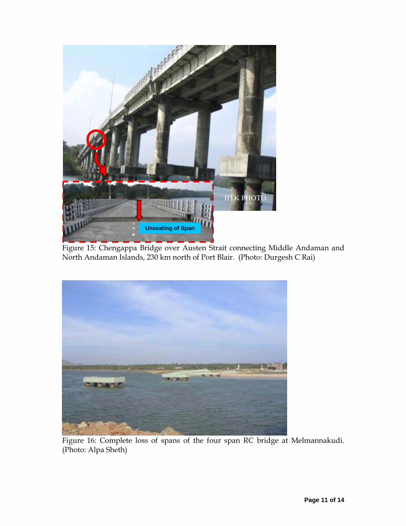
Damage to buildings and other structures were primarily due to tsunami (as against due to ground shaking) on the mainland India, and in Little Andaman and other islands south of it; structural damage in islands north of Little Andaman was primarily due to ground shaking. DAMAGES ON THE ANDAMAN & NICOBAR ISLANDS: Tsunami created giant waves as high as 10-12 m; in several instances, objects were found on top of the trees after the tsunami. In the islands of Great Nicobar, Car Nicobar, and Little Andaman, buildings constructed on the coast were washed away by the great waves, while those located on high grounds survived. When a number of rows of buildings existed on the coast, buildings in the first row from the sea suffered extensive damage while those in the rear rows did better due to the shielding provided by the front row. In general, constructions circular in plan (e.g., circular water tanks, light house) did better under the onslaught of tsunamis as the water could easily flow around such objects. At Car Nicobar about 100 personnel of air-force (including the family members) lost life or are missing. However, the operational area and the air-strip survived enabling rescue and relief operations by the air force after the event. Due to the ground shaking, the wooden buildings have performed very well as compared to the more modern RC frame and concrete block masonry buildings. The latter sustained large damage when the seismic codes were not complied with. For instance, the Passenger Terminal Building at the Phoenix Bay in Port Blair was recently constructed but did not comply with the seismic codes. This rather expensive building has been irreparably damaged. A number of houses built by local people using reinforced concrete but without proper engineering supervision and seismic detailing collapsed. A three-storey apartment building in Port Blair on stilt columns, not complying with the codal requirements, collapsed. Similar damages were also observed in Rangat, and Mayabandar in northern islands as well. A number of jetties collapsed or were severely damaged in a number of islands: this has severely affected the sea traffic and hence the relief operations. A new 268m long bridge between North Andaman and Middle Andaman at Austen Strait had to be closed to even the light vehicles. The superstructure has moved on the substructure by a substantial amount and middle three spans fell off from the bearing. Dr CVR Murty and Dr Durgesh C Rai of IIT Kanpur had visited this region two years back after a moderate earthquake on 14 September 2002 and in their published report had expressed concerns about this very bridge as follows:
“Inadequate seating of bridge deck over piers and abutments is a serious concern for its safely during a stronger earthquake in future. The bearings are simple neoprene pads which are far from satisfactory for a bridge located in seismic zone V. Bridge deck restrainers are the minimum that need to be provided to ensure that the spans are not dislodged from the piers in future earthquakes.”
The report can be downloaded from http://www.nicee.org/EQ_Reports/Andaman/AndamanReport.pdf. A free hard copy of the same can also be requested by sending an email with complete postal address to the National Information Center of Earthquake Engineering at IIT Kanpur ([email protected]).

Page 3 of 14
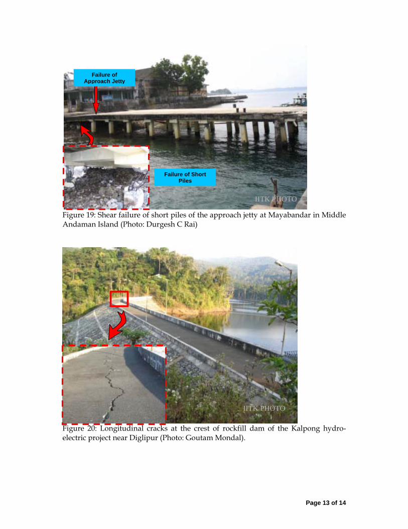
Widespread lateral spreading in Andaman Islands led significant damage to pavement and drainage structures of Andaman Trunk Road (ATR) and other link roads. Lateral spreading and other liquefaction related phenomenon were responsible for extensive damage to residential buildings and healthcare facilities in the low-lying areas, especially in the vicinity of water bodies, at several places in the northern Andaman Islands. The flexible airstrip at Diglipur developed on unconsolidated marshy land developed cracks. Electric power supply was severely affected: the 20 MW fossil-fuel based power plant at Bamboo Flat near Port Blair was flooded by tsunami waves causing extensive damage to electrical and mechanical equipment requiring several weeks for restoration. The 5.25 MW Kalpong Hydro-electric power plant near Diglipur, North Andaman Islands, also suffered damage to its turbines which could be restored only partially in a week�s time. The collapse of transmission tower at Middle Strait further restricted its power distribution to North Andaman Islands. Longitudinal cracks at the crest of its rockfill reservoir dam were also observed. DAMAGES ON THE MAINLAND The fishing community living along the shore suffered the maximum damage: to its housing, to its boats and fishing equipment, and in terms of loss of life. The other major sufferers were the tourists on some of the beaches. Most houses along the coast had been non-engineered. In general, quality of construction had a major influence on the level of damage sustained by the buildings. Buildings with low foundation depth, those with poorer building materials, poor integrity and poor workmanship were worst sufferers. Several bridges suffered serious damages. Super structure of all four spans of a bridge at Melmanakuddi came off the sub structure and two of the spans washed away to large distances. A good connection between the superstructure and the substructure and the additional provision of restraining upstands, recommended features for seismic design, would have helped these bridges. Infrastructure in Nagapattinam District was significantly affected: a railway line on the shore, telecommunication tower and control panel room were irreparably damaged. Compound walls upto 300m inside the shoreline were very extensively damaged. In ports and harbours, major disturbance was caused by vessels parting their ropes and becoming loose and hitting other vessels and causing damage. Small boats and ships were tossed astray onto the land by the incoming wave and thereby damaging them. Some boats were sunk to the basin due to the returning giant waves. Breakwaters generally did well, and helped reduce the impact of waves. Beaches shielded by land-mass or by rocky cliff sustained less damage. Sea-water intrusion was less in area covered with thick vegetation as compared to those with bare lands. Sand deposits due to tsunami in delta areas have damaged standing crops and affected fertility of the land. ATTACHED PHOTOS (21 Numbers) Comments and suggestions may be sent to: Sudhir K Jain at [email protected]

Page 4 of 14
Figure 1: Up-throw of coral beds and rock strata due to uplift on the western coast of middle Andaman Island near Flat Island. (Photo: Javed Malik)
Figure 2: Barren look with an occasional partially collapsed structure of an erstwhile-full military residential colony south of Malacca on the east coast of Car Nicobar Island. (Photo: CVR Murty)
IITK PHOTO
IITK PHOTO
Page 5 of 14
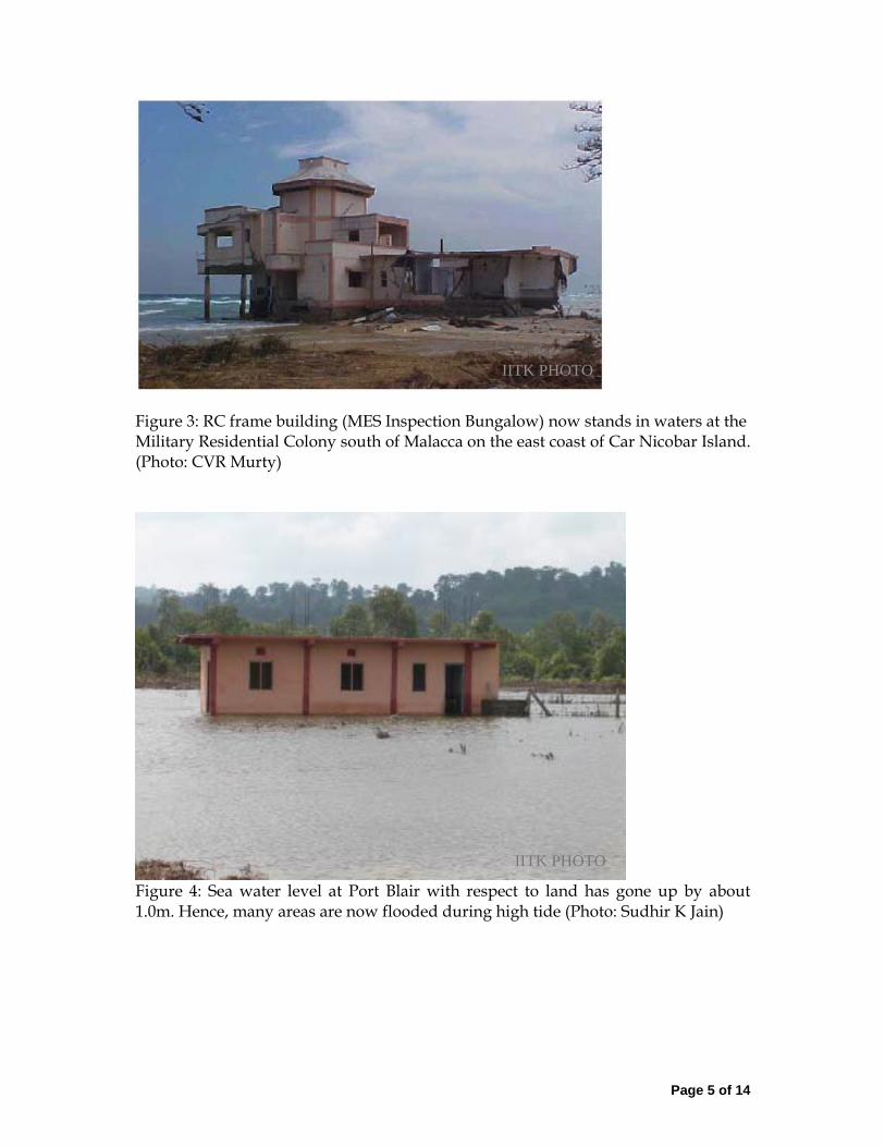
Figure 3: RC frame building (MES Inspection Bungalow) now stands in waters at the Military Residential Colony south of Malacca on the east coast of Car Nicobar Island. (Photo: CVR Murty)
Figure 4: Sea water level at Port Blair with respect to land has gone up by about 1.0m. Hence, many areas are now flooded during high tide (Photo: Sudhir K Jain)
IITK PHOTO
IITK PHOTO
Page 6 of 14
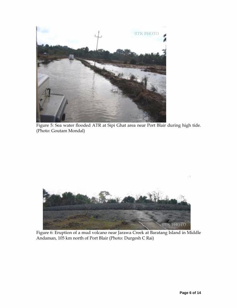
Figure 5: Sea water flooded ATR at Sipi Ghat area near Port Blair during high tide. (Photo: Goutam Mondal)
Figure 6: Eruption of a mud volcano near Jarawa Creek at Baratang Island in Middle Andaman, 105 km north of Port Blair (Photo: Durgesh C Rai)
IITK PHOTO
IITK PHOTO

Page 7 of 14
Figure 7: Ground deformation at Jarawa Creek, Baratang Island, Middle Andaman, (a) Damage to road connecting Baratang and Baludera Beach, (b) Splitting of a tree trunk due to ground rupture (≈1.2 m wide). (Photo: Goutam Mondal)
Figure 8: Ravaged houses at Nagapattinam due to poor constructions. (Photo: Alpa Sheth)
IITK PHOTO IITK PHOTO

Page 8 of 14
Figure 9: Small mechanized boat sunk into the harbour basin being pulled out of water at the Fisherman�s Wharf at the city of Chennai. (Photo: Arvind Jaiswal)
Figure 10: Severe damage to Passenger Terminal Building at Port Blair. (Photo: Sudhir K Jain)
IITK PHOTO

Page 9 of 14
Figure 11: Collapse of a three storey reinforced concrete frame building at Port Blair (Photo: Sudhir K Jain)
Figure 12: Collapse of a stilt Plus one storey house in reinforced concrete near Port Blair. (Photo: Sudhir K Jain)
IITK PHOTO
IITK PHOTO

Page 10 of 14
Figure 13: Collapse of a open storey reinforced concrete house at Rampur, near Mayabunder. (Photo: Durgesh C Rai)
Figure 14: Collapse of RC bare frame of three storey building under construction at Rangat, Middle Andaman Islands. (Photo: Durgesh C Rai)
IITK PHOTO
IITK PHOTO
Page 11 of 14
Figure 15: Chengappa Bridge over Austen Strait connecting Middle Andaman and North Andaman Islands, 230 km north of Port Blair. (Photo: Durgesh C Rai)
Figure 16: Complete loss of spans of the four span RC bridge at Melmannakudi. (Photo: Alpa Sheth)
Unseating of Span
IITK PHOTO

Page 12 of 14
Figure 17: Gandhinagar Jetty in North Andaman: Total collapse of the berthing Jetty and partial collapse of the approach jetty. (Photo: Durgesh C Rai)
Figure 18: Collapse of the 80m segment of approach in Great Nicobar Island jetty at Campbell Bay This has adversely affected the relief work. (Photo: CVR Murty)
Collapsed Berthing Jetty (Now Submerged)
Collapsed Approach Jetty
IITK PHOTO
IITK PHOTO
Page 13 of 14
Figure 19: Shear failure of short piles of the approach jetty at Mayabandar in Middle Andaman Island (Photo: Durgesh C Rai)
Figure 20: Longitudinal cracks at the crest of rockfill dam of the Kalpong hydro-electric project near Diglipur (Photo: Goutam Mondal).
Failure of Approach Jetty
Failure of Short Piles
IITK PHOTO
IITK PHOTO

Page 14 of 14
Figure 21: Collapse of electric power transmission tower at Middle Strait (between South and Middle Andaman Islands), disrupting the power supply from Kalpong Hydrolectric Project to Baratang island (Photo: Durgesh C Rai).
IITK PHOTO