Quaternary Science Reviewsboer0160/docs/Stocchi_etal_QSR_2017.pdf · Rosanna Sciortino e, Catherine...
9
A stalactite record of four relative sea-level highstands during the Middle Pleistocene Transition Paolo Stocchi a, * , Fabrizio Antonioli b , Paolo Montagna c , Fabrizio Pepe d , Valeria Lo Presti b , Antonio Caruso d , Marta Corradino d , Gino Dardanelli e , Pietro Renda d , Norbert Frank f , Eric Douville g , François Thil g , Bas de Boer h , Rosario Ruggieri i, j , Rosanna Sciortino e , Catherine Pierre k a NIOZ Royal Netherlands Institute for Sea Research, Department of Coastal Systems (COS), and Utrecht University, P.O. Box 59,1790 AB Den Burg, Texel, The Netherlands b ENEA National Agency for New Technologies, Energy and Environment, Via Anguillarese 301, 00060, S. Maria di Galeria, Rome, Italy c ISMAR-CNR, Via Gobetti 101, 40129 Bologna, Italy d Dipartimento di Scienze Della Terra e Del Mare, Via Archirafi, 22, Universit a di Palermo, Palermo, Italy e Dipartimento di Ingegneria Civile, Ambientale, Dei Materiali (DICAM), Universit a di Palermo, Viale Delle Scienze, Ed. 8, 90128 Palermo, Italy f Universit€ at Heidelberg, Im Neuenheimer Feld 229, 69120 Heidelberg, Germany g LSCE/IPSL, UMR 8212 CNRS-CEA-UVSQ, 91198, Gif-sur-Yvette, France h IMAU, Utrecht University, Utrecht, The Netherlands i CIRS Centro Ibleo di Ricerche Speleo-Idrogeologiche, Via Torrenuova 87, 97100, Ragusa, Italy j University of Nova Gorica, SI-5000, Nova Gorica, Slovenia k LOCEAN, Jussieu, Paris Cedex, France article info Article history: Received 15 March 2017 Received in revised form 15 July 2017 Accepted 7 August 2017 Keywords: Interglacial(s) Pleistocene Sea level changes Western Europe Speleothems Corals Stable isotopes U-Th dating 87 Sr/ 86 Sr ages abstract Ice-sheet and sea-level fluctuations during the Early and Middle Pleistocene are as yet poorly under- stood. A stalactite from a karst cave in North West Sicily (Italy) provides the first evidence of four marine inundations that correspond to relative sea-level highstands at the time of the Middle Pleistocene Transition. The speleothem is located ~97 m above mean sea level as result of Quaternary uplift. Its section reveals three marine hiatuses and a coral overgrowth that fixes the age of final marine ingression at 1.124 ± 0.2, thus making this speleothem the oldest stalactite with marine hiatuses ever studied to date. Scleractinian coral species witness light-limited conditions and water depth of 20e50 m. Inte- grating the coral-constrained depth with the geologically constrained uplift rate and an ensemble of RSL scenarios, we find that the age of the last marine ingression most likely coincides with Marine Isotope Stage 35 on the basis of a probabilistic assessment. Our findings are consistent with a significant Ant- arctic ice-sheet retreat. © 2017 Elsevier Ltd. All rights reserved. 1. Introduction Changes in solar radiation due to orbital forcing and variations in the concentrations of atmospheric greenhouse gases led to a succession of glacial and interglacial periods during the Pleistocene (Bintanja et al., 2005; De Boer et al., 2013; Rohling et al., 2014). Large fluctuations in ice volumes on both hemispheres resulted in significant sea-level changes that can be inferred from proxy re- cords such as benthic and planktonic foraminiferal d 18 O from deep- sea sediment cores (Rohling et al., 2014; Lisiecki and Raymo, 2004; Grant et al., 2014). However, d 18 O time series lack direct age control and require numerical iteration to decouple the convolved deep- water temperature and global ice mass signal (Bintanja et al., 2005; De Boer et al., 2014). Relative sea-level (RSL) changes can be permanently recorded by coastal geomorphological markers that are linked to coastal uplift (Ferranti et al., 2006; Antonioli et al., * Corresponding author. E-mail address: [email protected] (P. Stocchi). Contents lists available at ScienceDirect Quaternary Science Reviews journal homepage: www.elsevier.com/locate/quascirev http://dx.doi.org/10.1016/j.quascirev.2017.08.008 0277-3791/© 2017 Elsevier Ltd. All rights reserved. Quaternary Science Reviews 173 (2017) 92e100
Transcript of Quaternary Science Reviewsboer0160/docs/Stocchi_etal_QSR_2017.pdf · Rosanna Sciortino e, Catherine...
lable at ScienceDirect
Quaternary Science Reviews 173 (2017) 92e100
Contents lists avai
Quaternary Science Reviews
journal homepage: www.elsevier .com/locate/quascirev
A stalactite record of four relative sea-level highstands during theMiddle Pleistocene Transition
Paolo Stocchi a, *, Fabrizio Antonioli b, Paolo Montagna c, Fabrizio Pepe d,Valeria Lo Presti b, Antonio Caruso d, Marta Corradino d, Gino Dardanelli e, Pietro Renda d,Norbert Frank f, Eric Douville g, François Thil g, Bas de Boer h, Rosario Ruggieri i, j,Rosanna Sciortino e, Catherine Pierre k
a NIOZ Royal Netherlands Institute for Sea Research, Department of Coastal Systems (COS), and Utrecht University, P.O. Box 59, 1790 AB Den Burg, Texel, TheNetherlandsb ENEA National Agency for New Technologies, Energy and Environment, Via Anguillarese 301, 00060, S. Maria di Galeria, Rome, Italyc ISMAR-CNR, Via Gobetti 101, 40129 Bologna, Italyd Dipartimento di Scienze Della Terra e Del Mare, Via Archirafi, 22, Universit�a di Palermo, Palermo, Italye Dipartimento di Ingegneria Civile, Ambientale, Dei Materiali (DICAM), Universit�a di Palermo, Viale Delle Scienze, Ed. 8, 90128 Palermo, Italyf Universit€at Heidelberg, Im Neuenheimer Feld 229, 69120 Heidelberg, Germanyg LSCE/IPSL, UMR 8212 CNRS-CEA-UVSQ, 91198, Gif-sur-Yvette, Franceh IMAU, Utrecht University, Utrecht, The Netherlandsi CIRS Centro Ibleo di Ricerche Speleo-Idrogeologiche, Via Torrenuova 87, 97100, Ragusa, Italyj University of Nova Gorica, SI-5000, Nova Gorica, Sloveniak LOCEAN, Jussieu, Paris Cedex, France
a r t i c l e i n f o
Article history:Received 15 March 2017Received in revised form15 July 2017Accepted 7 August 2017
Keywords:Interglacial(s)PleistoceneSea level changesWestern EuropeSpeleothemsCoralsStable isotopesU-Th dating87Sr/86Sr ages
* Corresponding author.E-mail address: [email protected] (P. Stocchi).
http://dx.doi.org/10.1016/j.quascirev.2017.08.0080277-3791/© 2017 Elsevier Ltd. All rights reserved.
a b s t r a c t
Ice-sheet and sea-level fluctuations during the Early and Middle Pleistocene are as yet poorly under-stood. A stalactite from a karst cave in North West Sicily (Italy) provides the first evidence of four marineinundations that correspond to relative sea-level highstands at the time of the Middle PleistoceneTransition. The speleothem is located ~97 m above mean sea level as result of Quaternary uplift. Itssection reveals three marine hiatuses and a coral overgrowth that fixes the age of final marine ingressionat 1.124 ± 0.2, thus making this speleothem the oldest stalactite with marine hiatuses ever studied todate. Scleractinian coral species witness light-limited conditions and water depth of 20e50 m. Inte-grating the coral-constrained depth with the geologically constrained uplift rate and an ensemble of RSLscenarios, we find that the age of the last marine ingression most likely coincides with Marine IsotopeStage 35 on the basis of a probabilistic assessment. Our findings are consistent with a significant Ant-arctic ice-sheet retreat.
© 2017 Elsevier Ltd. All rights reserved.
1. Introduction
Changes in solar radiation due to orbital forcing and variationsin the concentrations of atmospheric greenhouse gases led to asuccession of glacial and interglacial periods during the Pleistocene(Bintanja et al., 2005; De Boer et al., 2013; Rohling et al., 2014).
Large fluctuations in ice volumes on both hemispheres resulted insignificant sea-level changes that can be inferred from proxy re-cords such as benthic and planktonic foraminiferal d18O from deep-sea sediment cores (Rohling et al., 2014; Lisiecki and Raymo, 2004;Grant et al., 2014). However, d18O time series lack direct age controland require numerical iteration to decouple the convolved deep-water temperature and global ice mass signal (Bintanja et al.,2005; De Boer et al., 2014). Relative sea-level (RSL) changes canbe permanently recorded by coastal geomorphological markersthat are linked to coastal uplift (Ferranti et al., 2006; Antonioli et al.,

P. Stocchi et al. / Quaternary Science Reviews 173 (2017) 92e100 93
2015). A common approach in constraining Pleistocene ice-sheetfluctuations is to date RSL markers such as shallow karst cavespeleothems and measure their elevations with respect to modernmean sea level. The subaerial growth of speleothems inside cavesthat are connected to the sea is interrupted during marine flood-ings. Successive marine inundations appear as series of concentrichiatuses within speleothem sections and can be converted into RSLchanges (Dutton et al., 2009; Richards et al., 1994). While paleo sea-level markers such as fossil beaches from the Pliocene have beenidentified worldwide (Rovere et al., 2014), speleothems that can beused as reliable RSL indicators that are older than 1 million yearsare extremely rare because of cliff retreat due to coastal erosion andactive tectonics (Breitenbach et al., 2005; Artyushkov, 2012).
In this work we reconstruct the conditions and the chronologyof the events that led to the occurrence and preservation of fourmarine ingressions that are recorded by a stalactite that is locatedinside the uplifted Rumena karst cave (RKC) in Custonaci, NorthWest Sicily (NWS; Figs. 1 and 2). The descriptive work of Ruggieriand De Waele (2014) provides information on the RKCmorphology as well as a tentative minimum age of 1200 ka for thecave based solely on the age of the corals encrustation as providedby Antonioli et al. (2012, 2014).
Here we adopt a multidisciplinary and quantitative approach bycombining geodetic measurements, dating techniques, geologicaland paleoecological observations and reconstructed RSL curves thatare based on proxy data and numerical modelling. We aim at pin-pointing the elevation of the uplifting stalactite in time and withrespect to the fluctuating sea level. Our main goal is to correlate themarine ingressions that are observed within the stalactite sectionto the RSL changes that characterize the proxy-based sea-levelcurves. We evaluate the bathymetric conditions during the lastflooding event with respect to present-day local sea level.
2. Geological settings and quaternary uplift rate
NWS is a segment of the Early Miocene to present-day Sicilian-Maghrebian Fold and Thrust Belt (Fig. 2). The latter consists of athin-skinned, south-verging fold and thrust system formed byMesozoiceTertiary carbonates, siliciclastic and evaporites, locallyoverlain by late orogenic clastic deposits (Catalano et al., 2000).Quaternary extensional and strike-slip faults deformed the nappepile and formed structural ridges and intervening basins (Mauzet al., 1997). Post Middle-Pleistocene coastal terraces are pres-ently distributed around the NWS at elevations up to 160 m abovemodern mean sea level (msl) (Di Maggio et al., 2009), thusdemonstrating that vertical uplift occurred as a consequence ofdeep-seated processes. A swarm of NW-SE and N-S/NNE-SSWtrending faults accommodates the structural separation betweenthe Rocca Rumena Ridge, where the cave karst formed, and theCastelluzzo and Cornino coastal plains (Fig. 2; Catalano et al., 2006).Close to Custonaci, eolian deposits (Fig. 3a and b) and shallowmarine depositional systems (Fig. 3c and d) are preserved aboveMesozoic-Paleogene carbonates at an elevation of 120 ± 10 mabove msl in close proximity to the RKC (see Fig. 2; Di Maggio et al.,2009). Although index fossils in these deposits are lacking, based onregional stratigraphic correlations, it has been proposed that theyformed during the transgressive depositional cycle of the EarlyPleistocene Calabrian Stage (Ruggeri et al., 1979), which comprisesthe Marine isotope Stages (MIS) 53e35 (Milli et al., 2013). The ab-solute age of 1.48 (±0.10) Ma inferred for the oldest deposits(Ruggeri et al., 1979) suggests a long-term linear uplift rate of0.081 ± 0.014 mm yr�1. The latter is consistent with a shorter-termestimate of ~0.08 mm yr�1 that is based on MIS 5e (~125,000 yearsago and assuming an elevation of ~6.0 m above msl paleo sea level)elevated coastal terraces that lie approximately 1 km to the west at
~16 m above msl (Antonioli et al., 2002; Lambeck et al., 2004).
3. Materials and methods
Here we describe our multidisciplinary approach that in-corporates instrumental geodetic measurements of the stalactiteelevation, laboratory analytical dating techniques for the age ofspeleothem and fossil corals and numerical modelling of RSLchange.
3.1. Orthometric height of the stalactite
The orthometric height of the stalactite is the result of two in-tegrated different geodetic surveying techniques: tacheometric andGNSS methods (Dardanelli et al., 2009). A static GNSS survey wasconducted on several control points close to the RKC with thefollowing acquisition parameters: 10 km baseline distance, obser-vation time 4 h for each point, cut-off angle 10� and rate 5 s. Thegoal of the survey was the estimation of geoid undulation withinthe investigated zone. The data were calculated relative to thereference station TRAP (Trapani) of the UNIPA NRTK GNSS perma-nent GNSS network (Dardanelli et al., 2009); the geodetic undula-tion is approximately 43.52 m. A triple-difference analysis wasperformed by means of Network Deformation Analysis softwarepackage, which makes ionospheric and tropospheric corrections.The modelling of the tropospheric delay was carried out by usingthe ideal gas law refractivity model published by (Saastamoinen,1972; Niell, 1996), while the modelling of ionospheric error wasperformed using the Total Electron Content (Klobuchar, 1996) withdaily parameter values supplied by the Center for Orbit Determi-nation in Europe of the Astronomical Observatory of the Universityof Bern. In addition, the ocean loading correction and the zenithtroposphere delay estimation (which affects the baseline co-ordinates) were based on a hydrodynamic model (Schwiderski,1980). We also performed a correction of antenna phase centerposition using precise ephemeris. To fix the phase ambiguity, weused the LAMBDA method associated with a secondary test on the“ratio” (Teunnisen et al., 1995), inserting the parameters of rotationof the Earth (Earth Orientation Parameters) and the values of theocean tides to obtain an accurate result. The difference in elevationbetween the stalactite and the known points was derived by meansof tacheometric levelling. Using the backward intersection method,we connected the tacheometric survey inside the cave to the GNSSsurvey.
3.2. U/Th dating
Two small pieces of carbonate (~200 mg) were extracted fromthe innermost and outermost layers of the stalactite (Fig. 1f) using adiamond-studded blade. The fragments were mechanically cleanedusing the diamond blade to remove any visible contamination,leached with 0.1 HCl and dissolved with diluted HCl. The solutionwas equilibrated with a mixed 236U/233U/229Th spike, and the U andTh fractions were separated using UTEVA resin (Eichrom Technol-ogies, USA). U and Th separation and purification followed a pro-cedure slightly modified from Douville et al. (2010). Uranium andthorium isotopes were analysed using a ThermoScientific Neptu-nePlus MC-ICP-MS at the Laboratoire des Sciences du Climat et del’Environnement in Gif-sur-Yvette. Mass bias was corrected usingan exponential mass fractionation law (normalized to the natural238U/235U isotopic ratio) and the standard/sample bracketingtechnique (using a mixture of our triple spike and HU-1). For moredetails on the analytical procedure see Pons-Branchu et al. (2014).

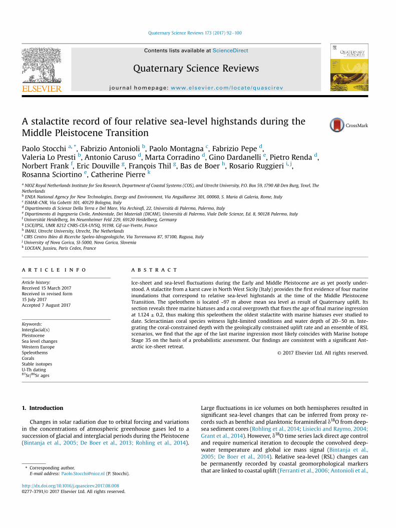
Fig. 1. Study area (a) and details of the RKC (bed). The cave wall (e) and the stalactite are covered by a coral encrustation. The stalactite section (f) reveals three concentric hiatuses.Lithophaga-produced boring holes penetrate the third hiatus. The external surface of the stalactite is covered by coral encrustations. The geographical coordinates of the RKC are38.07 N and 12.66 E (UTM WGS84).
P. Stocchi et al. / Quaternary Science Reviews 173 (2017) 92e10094
3.3. Strontium isotope analysis
Numerical ages of the encrusted corals (Fig. 1f) were estimatedusing Sr isotopes measured at the Laboratoire des Sciences du Cli-mat et de l’Environnement in Gif-sur-Yvette (France). Three small
coral fragments (3e5 mg) corresponding to the thecal walls wereextracted from the outermost coral overgrowth (Fig. 1f) and care-fully cleaned using a handheld dental drill bit in order to removethe external bioeroded zone, corresponding to ~400 mm. The in-ternal portion was further polished upon removal of other visible

Fig. 2. Simplified geological map of the study area in the North West Sicily (map adapted from the Geological Map at a scale 1:50.000 (CARG Project; Catalano et al., 2006).
P. Stocchi et al. / Quaternary Science Reviews 173 (2017) 92e100 95
contaminants. The sub-samples were examined using a binocularmicroscope to ensure against the presence of deep-penetrating andsediment-filled cavities and finally crushed into a powder with anagate mortar and pestle. The coral powder was rinsed three timeswith MilliQ water in acid-cleaned bullets before leaching with 0.3%acetic acid to remove 30e40% of CaCO3. This first leaching step is
designed to remove ions from exchangeable or leachable sites onthe mineral surfaces. The remaining material was rinsed withMilliQ water and leached again with 0.4% acetic acid to remove 30%of the CaCO3 for analysis, following the procedure published by Liet al. (2011). The supernatant solutions were evaporated andadjusted to 3 N HNO3 for ion exchange chromatography. The

Fig. 3. Thin Sections A and B e (samples Cu 13.1 and Cu 13.4) Photos of the eoliansandstones (qz - quartz; IO - iron oxide). C and D e (samples Cu 13.10a and Cu 13.10b.)Photos of calcarenites rich in foraminifera (El, Elphidium sp.; Gr e Globigerinoides ruber;Ec e Echinoid spine). Sites samples are indicated in Fig. 2.
P. Stocchi et al. / Quaternary Science Reviews 173 (2017) 92e10096
solutions were loaded into 300 ml columns containing 100e150 mmbead size Eichrom Sr-SPEC resin to remove matrix and isolate Srfrom other major and trace elements (e.g., the interfering elementsCa, Rb and REE). The columns were pre-flushed with 1 ml 3 N HNO3and 3 ml MilliQ-water and conditioned using 1 ml 3 N HNO3.Strontium was eluted from the columns with 2.5 ml MilliQ-water,and each solution was adjusted to 0.5 N HNO3 for isotopic mea-surements. A chemical blank was also prepared, following identicalprocedural steps. Strontium isotope ratios were measured using amulticollector-ICPMS ThermoScientific Neptune Plus. All the solu-tions were diluted to 50 ppb of Sr and introduced into the Neptuneusing an ESI-APEX desolvating system and a 100 ml/min nebulizer.The sensitivity of the 50 ppb Sr solution was approximately 8 V atthe 88Sr peak, and the chemical blank level was 0.008 V. Thesamples and standards were analysed in a static multi-collectionmode in a single block of 50 cycles with an integration time of 8 sper cycle. The instrumental mass fractionationwas corrected for byusing a stable isotopic 86Sr/88Sr ratio of 0.1194 and an exponentiallaw. No isobaric corrections for Ca dimers and argides wererequired, and only minor corrections for 87Rb to 87Sr wereconsidered. A correction was also applied for krypton isobaric in-terferences. Repeated measurements of strontium isotope standardNBS-987 during the analytical session yielded a mean 87Sr/86Srvalue of 0.710264 ± 0.000014 (2s SD, n ¼ 11, corresponding to anexternal reproducibility of 20 ppm). The 87Sr/86Sr ratio for all thesamples was corrected for instrumental bias to an accepted valuefor NBS-987 of 0.710248 (McArthur et al., 2001). All the 87Sr/86Srratios were converted into numerical ages using the regressioncurves LOWESS look-up Table version 4: 08/04 (revised from Liet al., 2011; see Table 1). The total uncertainty in 87Sr/86Sr(±0.000014) was calculated by adding in quadrature the analyticaluncertainty on the standard measurement (2s SD ¼ ±0.000014) tothe uncertainty of the LOWESS curve for the period considered(0e2 Ma ¼ ±0.000003), as suggested in equation (7.1) fromMcArthur et al. (2012). The lower and upper bounds on the ageswere calculated based on the total 87Sr/86Sr uncertainty (Table 1).
3.4. Reconstructed RSL curves
Three independent RSL change scenarios are considered for thetime interval between 0.9 and 1.5 Ma. The RSL-ANICE scenario
consists of an ensemble of RSL curves that are based on the ANICEglobal ice-sheet chronology (De Boer et al., 2014). The predicted RSLcurves account for local Glacial Isostatic Adjustment (GIA) andresult from the solution of the gravitationally self-consistent sealevel equation (SLE; Farrell and Clark, 1976) for a suite of mantleviscosity profiles. We solve the SLE bymeans of the pseudo-spectralmethod (Mitrovica and Milne, 2003) with SELEN Fortran 90 code(Spada and Stocchi, 2007). The solid Earth response to ice-sheetfluctuations is accounted for by a spherical, self-gravitating,rotating, radially stratified, deformable but incompressibleMaxwell viscoelastic Earth rheological model (Mitrovica andMilne,2003; Spada and Stocchi, 2007). We keep the elastic lithospherethickness fixed to 100 km. We vary the upper and lower mantleviscosity values between 0.25 and 1.0 � 1021 and 2 to10 � 1021 Pa∙s, respectively, and generate a combination of 20different mantle viscosity profiles. The second input of the SLE isthe forcing function, which represents the continental ice-sheetfluctuations through time. We employ two versions of the 2.2million years long ice-sheet chronology that is described by ANICEice-sheet model (De Boer et al., 2014). The first version does includethe contribution of summer austral insolation (SAI) to the AntarcticIce Sheet (AIS) variability (see AIS-SAI in Fig. 4), while in the secondversion of ANICE the SAI is not accounted for (see AIS-NSAI inFig. 4). Including SAI results in significant retreats of AIS during theinterglacials that characterize the MPT (Fig. 4). We solve the SLE for40 models (20 viscosity profiles x 2 ANICE versions) and computethe RSL curves at the location of the speleothem (red curve inFig. 5a). The second RSL scenario (RSL-Rohling14) is based on theRSL curve for Gibraltar that was derived by Rohling et al. (2014)through statistical analysis of previously published proxy datafrom Wang et al. (2010; green curve in Fig. 5a). The third scenario(RSL-Elderfield12) is complementary to RSL-Rohling14 and is basedon proxy data from Elderfield et al. (2012; green curve in Fig. 5a).Both proxy-based curves are corrected for the differential GIAresponse.
The average RSL change in time and its standard deviation areevaluated for all three RSL scenarios. These values are then used torandomly generate, by means of a Monte Carlo method, a normaldistribution of RSL values in time. The same is done for thereconstructed elevation of the speleothem (based on linear inter-polation). The four normal distributions are then overimposed toevaluate the probability (in time) for the speleothem to be inter-cepted by sea level and, consequently, to be located at a certaindepth with respect to sea level.
4. Results
On the basis of the method described in Section 3.1, we estimatethe orthometric height of the stalactite to be 97.12m. By shifting thecurrent elevation of the speleothem back in time according to thelinear uplift rate of 0.081 ± 0.014 mm yr�1 (see Section 2) andassuming that sea level has remained constant through time, aninterception with current msl occurs at ~ 1.225 Ma (Fig. 5a). Bothcalculated U/Th ages for the spelean carbonate layers are beyondthe upper limit of the 230Th age range, indicating an age older than~0.6 Ma (Cheng et al., 2013). The age of the stalactite is indirectlydetermined by analysing the coral overgrowth using the strontiumisotope dating method (see Section 3.3). The 87Sr/86Sr-derived agesof the three coral fragments encrusting the external surface of thespeleothem are identical within error (Table 1), suggesting that thecoral portions, which were carefully selected from the internal partof the thecal walls, were most likely pristine, and the ages can beconsidered reliable. Averaging the values of the three fragmentsyields a mean age for the corals of 1.124 ± 0.2 Ma, which representsthe age of the last marine ingression. The calculated standard

Table 187Sr/86Sr ages (Ma) of the corals encrusting the stalactite.
Sample ID Material Method 87Sr/86Sr Lower Age (Ma) Mean Age (Ma) Upper Age (Ma)
2572 Coral MC-ICP-MS 0.709130 (14) 0.814 1.131 1.2882573 Coral MC-ICP-MS 0.709137 (14) 0.665 1.023 1.2682574 Coral MC-ICP-MS 0.709124 (14) 0.957 1.218 1.460Mean value 1.1242 SD 0.2
P. Stocchi et al. / Quaternary Science Reviews 173 (2017) 92e100 97
deviation corresponds to 2s SD of the mean age. The latter broadlyagrees with the age of interception between the speleothem andcurrent msl.
The predicted RSL-ANICE ensemble is characterized by loweramplitude RSL fluctuations with respect to the proxy-based sce-narios (Fig. 5a). In particular, the predicted RSL highstands duringthe interglacial periods are significantly lower. Maximum RSL ele-vations of 4e6 m above current msl are found for MIS 25, 31 and 37and only for GIA solutions that account for the combination of theAIS sensitivity to austral summer insolation (see AIS-SAI in Fig. 4)and a high viscosity contrast between the upper and lower mantle.
When the three RSL scenarios are adopted, different numbersand timings of intersections between the uplifting stalactite andsea level occur at different elevations above current msl (Fig. 5a).The age and elevation of old shallowmarine deposits, together withthe age of the coral overgrowth and the number of hiatuses withinthe stalactite, are necessary constraints to reconstruct the chro-nology of marine inundations. In particular, the permissible livingdepth range for the corals is fundamental to pinpoint the elevationof the stalactite with respect to sea level during the fourth marine
Fig. 4. Antarctic Ice Sheet (AIS) and Greenand Ice Sheet (GIS) ice volumes (expressed in mlarger-than-today AIS during the interglacials that punctuate the MPT (solid red curve, AIS-Nlevel highstands above present-day msl (AIS-SAI; ~5.5 m at MIS 31, ~4 m at MIS 25, ~2 m atquite stable throughout the period under considerations. (For interpretation of the reference
ingression. Of the coral species that have been identified, Cladop-sammia rolandi indicates a water depth �20 m, with specimenscapable of surviving at depths�50munder normal light conditions(Rosso et al., 2015; Zibrowius,1978). Awater column height of 20mabove the stalactite is assumed as the minimum limit for the RSLpeak height during the formation of the coral. Accordingly, we use aMonte Carlo approach to generate normal distributions around themean values of, respectively, the elevation of the stalactite throughtime and the three RSL scenarios (Fig. 5a). We evaluate the prob-ability in time that the reconstructed RSL was at least 20 m abovethe predicted elevation of the cave within the plausible age rangefor the formation of the coral.We find that the RSL-ANICE ensembleis able to satisfy theminimum depth requirement during the fourthmarine ingression with very low probabilities, ~15% and ~10% forMIS 37 and 41, respectively (see Fig. 5b). Solutions for RSL-Rohling14 indicate MIS 37 and 35 as the most likely events, withprobabilities of 65% and 35%, respectively (see Fig. 5b). The sameoccurs for RSL-Elderfield12 scenarios, with the largest probability(100%) achieved for MIS 37, followed by MIS 35 (85%), MIS 39 (60%)and MIS 41 (65%) (see Fig. 5b).
eters of eustatic sea-level change) according to ANICE (22). Neglecting SAI results in aSAI). Accounting for SAI, instead, triggers significant retreats that result in eustatic sea-MIS 37). For both scenarios, the GIS is slightly larger than today (~1 m esl) and is alsos to colour in this figure legend, the reader is referred to the web version of this article.)

Fig. 5. (a) Elevation of the RKC in time (mean and standard deviation; dotted blue lines) with respect to three rsl change scenarios (95% confidence interval): RSL-ANICE (redshading), RSL-Rohling14 (blue shading), RSL-Elderfield12 (grey shading). The horizontal double-headed arrow indicates the age interval for the formation of the coral encrustation.(b) Probability of a water column height � 20 m above the corals according to the three rsl change scenarios. The probability decreases with time as a consequence of the uplift ofthe RKC and long-term rsl drop (with decreasing amplitude of shorter-term fluctuations). (For interpretation of the references to colour in this figure legend, the reader is referred tothe web version of this article.)
P. Stocchi et al. / Quaternary Science Reviews 173 (2017) 92e10098
5. Discussion
The requirement of a maximum of three interceptions beforethe formation of the coral encrustation restricts the range ofplausible solutions and shifts the chronological sequence of eventsto before the MIS 31 interglacial. Although MIS 37 is the most likelyevent for each of the three scenarios (Fig. 5b), the occurrence of acomparable RSL peak immediately afterwards suggests that theformation of the corals occurred during MIS 35, which is also closerin time to the mean age of the corals. The RSL highstands that
follow MIS 35 are characterized by lower amplitudes. According tothe RSL-Rohling14 and RSL-Elderfield12 scenarios, two in-terceptions between the stalactite and sea level might haveoccurred after MIS 35 and before MIS 23. However, these wouldhave resulted in lower highstands that could not have interferedwith previous coral encrustations. After MIS 25 the transition to-wards non-linear responses of ice sheet to astronomical andclimatological parameters resulted in long-period glaciations that,together with the uplift, prevented further marine inundation ofthe RKC.

P. Stocchi et al. / Quaternary Science Reviews 173 (2017) 92e100 99
The local sea level during the MIS 35 interglacial was 20e30 mhigher than present, which suggests that a significant retreat of theWest and East Antarctic Ice Sheet (WAIS and EAIS, respectively)occurred. The ANICE ice-sheet model reconstruction does not showa significant retreat of the AIS because the ice-sheet reconstructionis largely driven by the smoothed d18O stack curve (Lisiecki andRaymo, 2004), whereas regional RSL records might show moreamplified variability (De Boer et al., 2014; Konijnendijk et al., 2016).A marine transgression during MIS 35 was reported in form of achange in mollusks species recorded by sediments in the slowlyuplifting northern Po Plain (Gianolla et al., 2010). This correlates toan RSL highstand that was observed for the same region by Scardiaet al. (2006). Deep-sea sediment cores from two drilling sites offEast Antarctica (Prydz Bay and South Atlantic), however, show thatice-rafted debris was still being produced during MIS 35 (Teitleret al., 2015). This implies that there was an active sector of theEAIS that was capable of launching icebergs into the SouthernOcean. Only later, between MIS 33 and 31, did a widespread retreatof AIS, with increased contributions from EAIS, occur, resulting inan abrupt change in sedimentation. We argue, therefore, that thedrilling sites studied by Teitler et al. (2015) might have been mostlysensitive to the northeastern portion only of the EAIS, which wasstill active during the MIS 35 interglacial. The far-field site of Cus-tonaci, instead, recorded the cumulative response of local sea levelto the retreat of WAIS and southern portions of EAIS.
6. Conclusions
The RKC speleothem section is the oldest stalactite containingmarine hiatuses ever studied to date and is the first directgeological evidence of RSL changes during the MPT. The formationand subsequent preservation of the three hiatuses and of the coralsencrustation are direct consequences of two independent pro-cesses that worked in opposite direction. Quaternary uplift, whichis a reflection of deep-seated geodynamic processes, first facilitatedmarine ingressions by elevating the RKC towards msl. During thistime, higher-frequency RSL fluctuations left permanent marks inthe speleothem, which was very close to current msl. The transitionfrom 41,000 to 100,000 years periodicity in RSL fluctuationscontributed to the permanent disconnection of the uplifting cavewith msl and prevented any further inundation. The corals en-crustations, which mark the last marine ingression, show that localsea level rose up to 20e30 m above present. This implies thatamong the several factors that contributed to local RSL rise, a sig-nificant AIS retreat likely occurred. Our results, combined withcoeval AIS-proximal sedimentological observations, confirm thatthe variability of AIS during climate transitions is sectoral (Teitleret al., 2015). The evidence presented in this study agrees withpredictions for both the past and near future of AIS response toclimate variability and show that different portions of EAIS likelycontribute to sea-level highstands during warm periods (Pollardand Deconto, 2009; Dutton et al., 2015).
Acknowledgments
We are thankful to David Richards, Christian Ohneiser andEnrico Di Stefano for their helpful comments. This work was partlyfinancially supported by the grant “Fondo Finalizzato alla Ricerca2012/2013 (CUP B71J12001450001)” funded by the University ofPalermo (Italy). Bas de Boer is funded by NWO Earth and Life Sci-ences (ALW), project 863.15.019.
References
Antonioli, F., Cremona, G., Immordino, F., Puglisi, C., Romagnoli, C., Silenzi, S.,
Valpreda, E., Verrubbi, V., 2002. New data on the holocenic sea-level rise in NWsicily (central mediterranean sea). Glob. Planet. Change 34, 121e140.
Antonioli, F., Montagna, P., Caruso, A., Ruggieri, R., Lo Presti, V., Silenzi, S., Frank, N.,Douville, E., Pierre, C., 2012. Investigation of Marine and Continental Layers in aStalactite Older than 1 Million Years (Custonaci, North-western Sector of Sicily).SLALOM 2012, abstract volume, Athens 19e22 March 2012, pp. 57e58.
Antonioli, F., Ruggieri, R., Montagna, P., Pepe, F., Caruso, A., Stocchi, P., Renda, P., LoPresti, V., Frank, N., Douville, E., Pierre, C., Messina Panfalone, D., 2014. Thegeosite Rumena cave a unique paleoclimate and sea level archive in the Med-iterranean area (northwestern Sicily). In: 4th International Symposium, KarstGeosites, Abstract Volume, Favignana 30 Maye2 June, pp. 64e66.
Antonioli, F., Lo Presti, V., Rovere, A., Ferranti, L., Anzidei, M., Furlani, S.,Mastronuzzi, G., Orru, P.E., Scicchitano, G., Sannino, G., 2015. Tidal notches inmediterranean sea: a comprehensive analysis. Quat. Sci. Rev. 119, 66e84.
Artyushkov, E.V., 2012. Vertical crustal movements on the continents as a reflectionof deep-seated processes in the earth's crust and mantle: geological effects. Her.Russ. Acad. Sci. 82 (6), 432e446.
Bintanja, R., Van de Wal, R.S.W., Oerlemans, J., 2005. Modelled atmospheric tem-peratures and global sea level over the past million years. Nature 437, 125e128.
Breitenbach, S., Fernandez, D., Adkins, J., Mingram, B., Oberh€ansli, H., Haug, G., 2005.Speleothem records older than 500 ka from Southern Siberia. In: Proc. 14thInternational Conference of Speleology, Athens 2005, pp. 1e7.
Catalano, R., Franchino, A., Merlino, S., Sulli, A., 2000. Central western Sicilystructural setting interpreted from seismic reflection profiles. Mem. Soc. Geol.It. 55, 5e16.
Catalano, R., Abate, B., Agate, M., Basilone, L., Di Maggio, C., Di Maio, D.,Mancuso, M., Sulli, A., Vaccaro, F., Arnone, M., Avellone, G., Barchi, M.,Bonomo, S., Cottone, S., D'Argenio, A., Fallo, L., Lo Cicero, G., Lo Iacono, C.,Lucido, M., Pepe, F., Scannavino, M., Sprovieri, R., 2006. Carta geologica d'Italiaalla scala 1:50.000 del foglio 593 “Castellammare del Golfo”. Progetto CARG 1.
Cheng, H., Edwards, R.L., Shen, C.-C., Polyak, V.J., Asmeron, Y., Woodhead, J.,Hellstrom, J., Wang, Y., Kong, X., Sp€otl, C., Wang, X., Alexander Jr., E.C., 2013.Improvements in 230Th dating, 230Th and 234U half-life values, and U/Th isotopicmeasurements by multi-collector inductively coupled plasma mass spectrom-etry. Earth Planet. Sci. Lett. 371-372, 82e91.
Dardanelli, G., Franco, V., Lo Brutto, M., 2009. Accuracy and reliability in GNSS NRTK.In: Proceedings of European Navigation Conference - Global Navigation SatelliteSystems. Naples, Italy.
De Boer, B., Van de Wal, R.S.W., Lourens, L.J., Bintanja, R., 2013. A continuoussimulation of global ice volume over the past 1 million years with 3-D ice-sheetmodels. Clim. Dyn. 41, 1365e1384.
De Boer, B., Lourens, L.J., Van de Wal, R.S.W., 2014. Persistent 400,000-year vari-ability of Antarctic ice volume and the carbon cycle is revealed throughout thePlio-Pleistocene. Nat. Commun. 5:2999 http://dx.doi.org/10.1038/ncomms3999.
Di Maggio, C., Agate, M., Contino, A., Basilone, L., Catalano, R., 2009. Unconformity-bounded stratigraphic units of quaternary deposits mapped for the CARGProject in northern and western sicily. Alp. Mediterr. Quat. 22 (2), 354e364.
Douville, E., Salle, E., Frank, N., Eisele, M., Pons-Branchu, E., Ayrault, S., 2010. Rapidand accurate U- Th dating of ancient carbonates using inductively coupledplasma-quadrupole mass spectrometry. Chem. Geol. 272, 1e11.
Dutton, A., Bard, E., Antonioli, F., Esat, T.M., Lambeck, K., McCulloch, M.T., 2009.Phasing and amplitude of sea level and climate change during the penultimateinterglacial. Nat. Geosci. 355e359.
Dutton, A., Carlson, A.E., Long, A.J., Milne, G.A., Clark, P.U., DeConto, R., Horton, B.P.,Rahmstorf, S., Raymo, M.E., 2015. Sea-level rise due to polar ice-sheet mass lossduring past warm periods. Science 349. http://dx.doi.org/10.1126/science.aaa4019.
Elderfield, H., et al., 2012. Evolution of ocean temperature and ice volume throughthe Mid-Pleistocene climate transition. Science 337, 704e709.
Farrell, W.E., Clark, J.A., 1976. On postglacial sea level. Geophys. J.R. Astron. Soc. 46,647e667.
Ferranti, L., Antonioli, F., Mauz, B., Amorosi, A., Dai Pra, G., Mastronuzzi, G.,Monaco, C., Orrù, P., Pappalardo, M., Radtke, U., Renda, P., Romano, P., Sans�o, P.,Verrubbi, V., 2006. Markers of the last interglacial sea-level high stand alongthe coast of Italy: tectonic implications. Quat. Int. 145-146, 30e54.
Gianolla, D., Negri, M., Basso, D., Sciunnach, D., 2010. Malacological response toPleistocene sea-level change in the northern Po Plain, N. Italy: detailed palae-oenvironmental reconstructions from two lombardian cores. Riv. Ital. Paleontol.Stratigr. 116 (1), 79e102.
Grant, K.M., Rohling, E.J., Bronk Ramsey, C., Cheng, H., Edwards, R.L., Florindo, F.,Heslop, D., Marra, F., Roberts, A.P., Tamisiea, M.E., Williams, F., 2014. Sea-levelvariability overt five glacial cycles. Nat. Commun. http://dx.doi.org/10.1038/ncomms6076.
Klobuchar, J.A., 1996. Global Positioning System: Theory and Applications. Volume I,Cap. XII: Ionospheric Effects on GPS. American Institute of Aeronautics andAstronauitcs Inc, pp. 485e515.
Konijnendijk, T.Y.M., Ziegler, M., Lourens, L.J., 2016. On the timing and forcingmechanisms of late Pleistocene glacial terminations: insights from a new high-resolution benthic stable oxygen isotope record of the eastern Mediterranean.Quat. Sci. Rev. 129, 308e320. http://dx.doi.org/10.1016/j.quascirev.2015.10.005.
Lambeck, K., Antonioli, F., Purcell, A., Silenzi, S., 2004. Sea level change along theItalian coast for the past 10,000 years. Quat. Sci. Rev. 23, 1567e1598.
Li, D., Shields-Zhou, G.A., Ling, H.F., Thirlwall, M., 2011. Dissolution methods forstrontium isotope stratigraphy: guidelines for the use of bulk carbonate andphosphorite rocks. Chem. Geol. 290, 133e144.

P. Stocchi et al. / Quaternary Science Reviews 173 (2017) 92e100100
Lisiecki, L., Raymo, M., 2004. A Pliocene-Pleistocene stack of 57 globally distributedbenthic d18O records. Paleoceanography 20, PA1003. http://dx.doi.org/10.1029/2004PA001071.
Mauz, B., Buccheri, G., Zoller, L., Greco, A., 1997. Middle to upper Pleistocene mor-phostructural evolution of the NW coast of Sicily: thermoluminescence datingand paleontological stratigraphical evaluations of littoral deposits. Palaeogeogr.Palaeoecol. Palaeogeogr. 128, 269e285.
McArthur, J.M., Howarth, R.J., Bailey, T.R., 2001. Strontium isotope stratigraphy:LOWESS version 3: best fit to theMarine Sr-Isotope curve for 0e509 Ma andaccompanying look-up table for deriving numerical age. J. Geol. 109, 155e170.
McArthur, J.M., Howarth, R.J., Shields, G.A., 2012. Strontium isotope stratigraphy. In:Gradstein, F., Ogg, J., Schmitz, M., Ogg, G. (Eds.), The Geologic Time Scale 2012.Elsevier, pp. 127e144.
Milli, S., D'Ambrogi, C., Bellotti, P., Calderoni, G., Garboni, M.G., Celant, A., Di Bella, L.,Di Rita, F., Frezza, V., Magri, D., Pichezzi, R.M., Ricci, V., 2013. The transition fromwave-dominated estuary to wave-dominated delta: The Late Quaternarystratigraphic architecture of Tiber River deltaic succession (Italy). Sediment.Geol. 284e285, 159e180.
Mitrovica, J.X., Milne, G.A., 2003. On post-glacial sea level: I. General theory. Geo-phys. J. Int. 154, 253e267.
Niell, A.E., 1996. Global mapping functions for the atmosphere delay at radiowavelengths. J. Geophys. Res. 100 (B2), 3227e3246.
Pollard, D., Deconto, R.M., 2009. Modelling West Antarctic ice sheet growth andcollapse through the past five million years. Nature 458, 329e333.
Pons-Branchu, E., Douville, E., Roy-Barman, M., Dumont, E., Branchu, P., Thil, F.,Frank, N., Bordier, L., Borst, W., 2014. A geochemical perspective on Parisianurban history based on U-Th dating, laminae counting and yttrium and REEconcentrations of recent carbonates in underground aqueducts. Quat. Geo-chronol. 24, 44e53.
Richards, D.A., Smart, P.L., Edwards, R.L., 1994. Maximum sea levels for the lastglacial period from U-series ages of submerged speleothems. Nature 367,357e360.
Rohling, E.J., Foster, G.L., Grant, K.M., Marino, G., Roberts, A.P., Tamisiea, M.E.,Williams, F., 2014. Sea-level and deep-sea-temperature variability over the past5.3 million years. Nature 508, 477e482. http://dx.doi.org/10.1038/nature13230.
Rovere, A., Raymo, M.E., Mitrovica, J.X., Hearthy, P.J., O'Leary, M.J., Inglis, J.D., 2014.The Mid-Pliocene sea-level conundrum: glacial isostasy, eustasy and dynamictopography. Earth Planet. Sci. Lett. 387, 27e33.
Rosso, A., Sanfilippo, R., Ruggieri, R., Maniscalco, R., Vertino, A., 2015. Exceptionalrecord of submarine cave communities from the Pleistocene of Sicily (Italy).Lethaia 48, 133e144.
Ruggeri, G., Sprovieri, R., Unti, M., 1979. Evidenze della trasgressione dell'Emiliano(Pleistocene inferiore) nella Sicilia Orientale. Boll. Soc. Geol. It. 98, 469e473.
Ruggieri, R., De Waele, J., 2014. Lower- to Middle Pleistocene flank margin caves atCustonaci (Trapany, NW Sicily) and their relation with past sea levels. ActaCarsologica 43/1, 11e22.
Saastamoinen, J., 1972. Atmospheric correction for the troposphere and strato-sphere in radio ranging of satellites. Geophys. Monogr. 15. AmericanGeophysical Union, Washington DC.
Scardia, G., Muttoni, G., Sciunnach, D., 2006. Subsurface magnetostratigraphy ofPleistocene sediments from the Po Plain (Italy): constraints on rates of sedi-mentation and rock uplift. GSA Bull. 118 (11/12), 1299e1312. http://dx.doi.org/10.1130/B25869.1.
Schwiderski, E.W., 1980. On charting global ocean tides. Rev. Geophys. Space Phys.18, 243e268.
Spada, G., Stocchi, P., 2007. SELEN: a Fortran 90 program for solving the “sea-levelequation”. Comput. Geosciences 33, 538e562.
Teitler, L., Florindo, F., Warnke, D.A., Filippelli, G.M., Kupp, G., Taylor, B., 2015.Antarctic Ice Sheet response to a long warm interval across Marine IsotopeStage 31: a cross-latitudinal study of iceberg-rafted debris. Earth Planet. Sci.Lett. 409, 109e119.
Teunnisen, P.J.G., de Longe, P.J., Tiberius, C.C.J.M., 1995. The LAMBDA-method for fastGPS surveying. In: International Symposium “GPS Technology Applications”.Bucharest, Romania.
Wang, P., Tian, J., Lourens, L.J., 2010. Obscuring of long eccentricity cyclicity inPleistocene oceanic carbon isotope records. Earth Planet. Sci. Lett. 290,319e330.
Zibrowius, H., 1978. Les Scleractiniaires des grotte sous-marine en Mediterranee etdans l'Atlantique nord-orientale (Portugal,Madere, Canaries, Azores). Pub-blicazioni della Stazione Zool. Napoli 40, 516 545.25.