Quaternary geology of Manitoba: digital … of Activities 2012 189 Quaternary geology of Manitoba:...
5
189 Report of Activities 2012 Quaternary geology of Manitoba: digital compilation of point and line data, with updating of the dataset using remotely sensed (SPOT) imagery by M.S. Trommelen, G.R. Keller and B.K. Lenton GS-18 Trommelen, M.S., Keller, G.R. and Lenton, B.K. 2012: Quaternary geology of Manitoba: digital compilation of point and line data, with updating of the dataset using remotely sensed (SPOT) imagery; in Report of Activities 2012, Manitoba Innovation, Energy and Mines, Manitoba Geological Survey, p. 189–193. Summary The aim of this project is to provide an up-to-date digital compilation of historic and new ice-flow and geomorphic data to better assist drift prospecting, land-use and research projects in Manitoba. Current objectives of the project are to compile data, complete quality control, update with high-resolution remote-sensing imagery (SPOT 1 ) and digitized aerial photographs, and augment with newly acquired field data. Introduction Up-to-date, queryable surficial geological data are essential for the successful interpretation of ice flow and glacial history in Manitoba. These data are used by the agriculture, land-use, aggregate, groundwater, environment, hazard and exploration industries, which all require current knowledge to make effective decisions. Manitoba has successfully compiled and released seamless queryable digital surficial-material maps (Matile and Keller, 2007), but these compilations do not include point and line features. The aim of this new project is to fill that gap by updating the existing digital surficial compilation to include such features. To further enhance this compilation, an interpretation of the ice-flow indicator and streamlined landform database is being completed by the lead author. Objectives The objectives of this project are to • digitize all ice-flow indicators and surficial landforms from all pre-existing Quaternary geology maps in Manitoba; • achieve consistency with the existing (McMartin et al., 2010) digital compilations completed for northwestern Manitoba (NTS 63I, J, O, P, 64A, B, C, F, G, H); and • update mapping at a more detailed scale, using remotely sensed imagery. Methods Compilation Digitization and edge-matching of all point and line features from pre-existing surficial geology maps in Manitoba at the most detailed scales available, along with a database index of metadata, has been completed (Figure GS-18-1). Tables GS-18-1 and -2 provide a list of the included line and point features. Line features are digitized to scale, whereas points represent features occurring at a site but are not to scale. Because this is a compilation, not all original data—such as site numbers, striae characteristics (type, position, abundance) and fossil radiocarbon lab numbers—are preserved. Instead, the compiled database will serve as a guide and the reader will be referred to the original maps and publications for more information. Update Remotely sensed re-interpretation and new mapping of point and line features is ongoing for the entire province. This is possible because of the recent release of panchromatic SPOT 4/5 imagery (10 m resolution; Geobase ® , 2005–2010). A comparison of the imagery resolutions is presented in Figure GS-18-2. A major part of this compilation is the re-interpretation of preliminary reconnaissance point ice-flow features (e.g., streamlined features and drumlins) into line features to ensure consistency and completeness of the dataset. Care was taken to ensure that bedrock structures were not mapped as glacial landforms by referring to published bedrock maps. Compilations using the Shuttle Radar Topography Mission (SRTM, 90 m resolution; United States Geological Survey, 2002), Landsat 7 Enhanced Thematic Mapper Plus (ETM+; 15 m resolution, Geobase ® , 1999- 2003) and select digital aerial photographs have already been released for parts of northwestern (McMartin et al., 2010) and northern (Trommelen and Ross, 2010) Manitoba. Products The planned release of the new and updated data will give users the ability to add the point and line features to the existing Surficial Geology Compilation Map Series of Manitoba (Matile and Keller, 2007). The data will also be available as a queryable layer in the Manitoba Geological Survey’s GIS Map Gallery. In 2013, a new set of 1:250 000 scale surficial geology maps with integrated point and line features will be released as downloadable PDF files. 1 Système Pour l’Observation de la Terre
Transcript of Quaternary geology of Manitoba: digital … of Activities 2012 189 Quaternary geology of Manitoba:...
189Report of Activities 2012
Quaternary geology of Manitoba: digital compilation of point and line data, with updating of the dataset using remotely sensed
(SPOT) imageryby M.S. Trommelen, G.R. Keller and B.K. Lenton
GS-18
Trommelen, M.S., Keller, G.R. and Lenton, B.K. 2012: Quaternary geology of Manitoba: digital compilation of point and line data, with updating of the dataset using remotely sensed (SPOT) imagery; in Report of Activities 2012, Manitoba Innovation, Energy and Mines, Manitoba Geological Survey, p. 189–193.
SummaryThe aim of this project is to provide an up-to-date
digital compilation of historic and new ice-flow and geomorphic data to better assist drift prospecting, land-use and research projects in Manitoba. Current objectives of the project are to compile data, complete quality control, update with high-resolution remote-sensing imagery (SPOT1) and digitized aerial photographs, and augment with newly acquired field data.
IntroductionUp-to-date, queryable surficial geological data are
essential for the successful interpretation of ice flow and glacial history in Manitoba. These data are used by the agriculture, land-use, aggregate, groundwater, environment, hazard and exploration industries, which all require current knowledge to make effective decisions. Manitoba has successfully compiled and released seamless queryable digital surficial-material maps (Matile and Keller, 2007), but these compilations do not include point and line features. The aim of this new project is to fill that gap by updating the existing digital surficial compilation to include such features. To further enhance this compilation, an interpretation of the ice-flow indicator and streamlined landform database is being completed by the lead author.
ObjectivesThe objectives of this project are to
• digitize all ice-flow indicators and surficial landforms from all pre-existing Quaternary geology maps in Manitoba;
• achieve consistency with the existing (McMartin et al., 2010) digital compilations completed for northwestern Manitoba (NTS 63I, J, O, P, 64A, B, C, F, G, H); and
• update mapping at a more detailed scale, using remotely sensed imagery.
Methods
CompilationDigitization and edge-matching of all point and
line features from pre-existing surficial geology maps
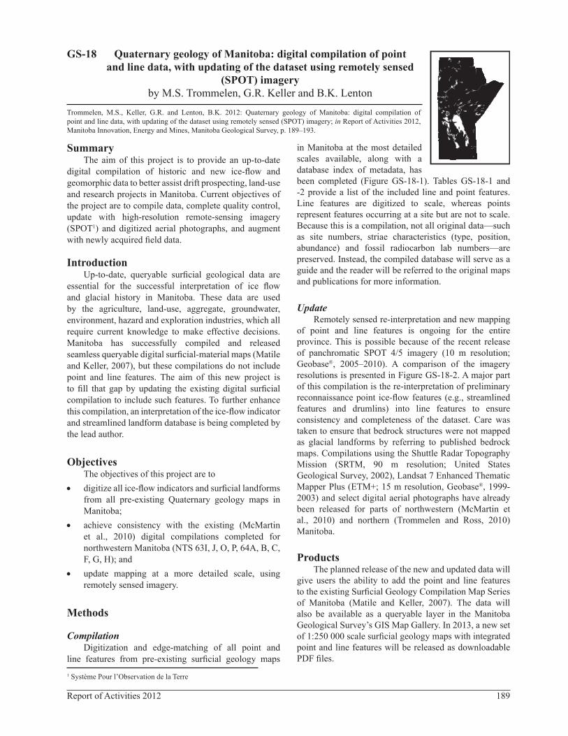
in Manitoba at the most detailed scales available, along with a database index of metadata, has been completed (Figure GS-18-1). Tables GS-18-1 and -2 provide a list of the included line and point features. Line features are digitized to scale, whereas points represent features occurring at a site but are not to scale. Because this is a compilation, not all original data—such as site numbers, striae characteristics (type, position, abundance) and fossil radiocarbon lab numbers—are preserved. Instead, the compiled database will serve as a guide and the reader will be referred to the original maps and publications for more information.
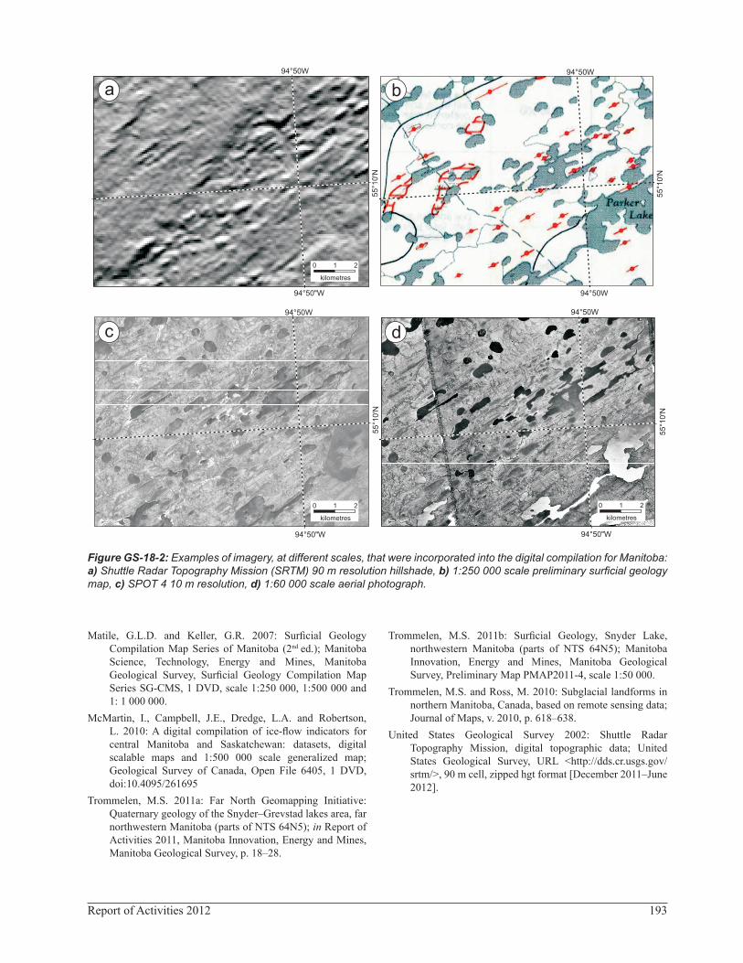
UpdateRemotely sensed re-interpretation and new mapping
of point and line features is ongoing for the entire province. This is possible because of the recent release of panchromatic SPOT 4/5 imagery (10 m resolution; Geobase®, 2005–2010). A comparison of the imagery resolutions is presented in Figure GS-18-2. A major part of this compilation is the re-interpretation of preliminary reconnaissance point ice-flow features (e.g., streamlined features and drumlins) into line features to ensure consistency and completeness of the dataset. Care was taken to ensure that bedrock structures were not mapped as glacial landforms by referring to published bedrock maps. Compilations using the Shuttle Radar Topography Mission (SRTM, 90 m resolution; United States Geological Survey, 2002), Landsat 7 Enhanced Thematic Mapper Plus (ETM+; 15 m resolution, Geobase®, 1999-2003) and select digital aerial photographs have already been released for parts of northwestern (McMartin et al., 2010) and northern (Trommelen and Ross, 2010) Manitoba.
ProductsThe planned release of the new and updated data will
give users the ability to add the point and line features to the existing Surficial Geology Compilation Map Series of Manitoba (Matile and Keller, 2007). The data will also be available as a queryable layer in the Manitoba Geological Survey’s GIS Map Gallery. In 2013, a new set of 1:250 000 scale surficial geology maps with integrated point and line features will be released as downloadable PDF files.
1 Système Pour l’Observation de la Terre
190 Manitoba Geological Survey
Figure GS-18-1: Existing surficial geology maps of Manitoba at scales ranging from 1:50 000 to 1:500 000; these maps are mainly from the Geological Survey of Canada but also from the Manitoba Geological Survey.
Data reliabilityThis compilation is based predominantly on remotely
sensed imagery, incorporating data presented at various scales from different types of imagery. The data are considered more accurate where detailed (1:50 000 scale) surficial geology maps were produced, or where areas were updated using 1:60 000 scale aerial photographs. As with all remotely sensed imagery, information gleaned from fieldwork is more accurate. For example,
in the Snyder Lake area of far northwestern Manitoba (Trommelen, 2011a, b), abundant secondary meltwater has modified the original landscape. This modification has tended to mask primary subglacial landforms on both aerial photographs and remotely sensed imagery, and, as discovered during fieldwork, led to incorrect remotely sensed mapping. In these areas, fieldwork is necessary to determine the extent of secondary modification and to enable better recognition of primary features. Note that
191Report of Activities 2012
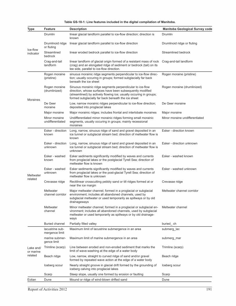
Table GS-18-1: Line features included in the digital compilation of Manitoba.
Type Feature Description Manitoba Geological Survey code
Ice-flow indicator
Drumlin linear glacial landform parallel to ice-flow direction; direction is known
Drumlin
Drumlinoid ridge or fluting
linear glacial landform parallel to ice-flow direction Drumlinoid ridge or fluting
Streamlined bedrock
linear eroded bedrock parallel to ice-flow direction Streamlined bedrock
Crag-and-tail landform
linear landform of glacial origin formed of a resistant mass of rock (crag) and an elongated ridge of sediment or bedrock (tail) on its lee side, parallel to ice-flow direction.
Crag-and-tail landform
Moraines
Rogen moraine (pristine)
sinuous morainic ridge segments perpendicular to ice-flow direc-tion; usually occuring in groups; formed subglacially far back beneath the ice sheet
Rogen moraine (pristine)
Rogen moraine (drumlinized)
Sinuous morainic ridge segments perpendicular to ice-flow direction, whose surfaces have been subsequently modified (streamlined) by actively flowing ice; usually occuring in groups; formed subglacially far back beneath the ice sheet
Rogen moraine (drumlinized)
De Geer moraine
Low, narrow morainic ridges perpendicular to ice-flow direction; deposited into proglacial lakes
De Geer moraine
Major moraine Major morainic ridges; includes frontal and interlobate moraines Major moraine
Minor moraine undifferentiated
Undifferentiated minor morainic ridges forming small morainic segments, usually occuring in groups; mainly recessional moraines
Minor moraine undifferentiated
Meltwater related
Esker - direction known
Long, narrow, sinuous ridge of sand and gravel deposited in an ice tunnel or subglacial stream bed; direction of meltwater flow is known
Esker - direction known
Esker - direction unknown
Long, narrow, sinuous ridge of sand and gravel deposited in an ice tunnel or subglacial stream bed; direction of meltwater flow is unknown
Esker - direction unknown
Esker - washed known
Esker sediments significantly modified by waves and currents from proglacial lakes or the postglacial Tyrell Sea; direction of meltwater flow is known
Esker - washed known
Esker - washed unknown
Esker sediments significantly modified by waves and currents from proglacial lakes or the post-glacial Tyrell Sea; direction of meltwater flow is unknown
Esker - washed unknown
Crevasse ridge Rectilinear crosscutting pebbly sand or till ridges formed at or near the ice margin
Crevasse ridge
Meltwater channel corridor
Major meltwater channel; formed in a proglacial or subglacial environment; includes all abandoned channels, used by subglacial meltwater or used temporarily as spillways or by old drainageways
Meltwater channel corridor
Meltwater channel
Minor meltwater channel; formed in a proglacial or subglacial en-vironment; includes all abandoned channels, used by subglacial meltwater or used temporarily as spillways or by old drainage-ways
Meltwater channel
Buried channel Partially filled valley buried_ ch
Lake and/or marine related
lacustrine sub-mergence limit
Maximum limit of lacustrine submergence in an area submerg_lac
marine submer-gence limit
Maximum limit of marine submergence in an area submerg_mar
Trimline (scarp) Line between eroded and non-eroded sediment that marks the limit of wave-washing at the edge of a water body
Trimline (scarp)
Beach ridge Low, narrow, straight to curved ridge of sand and/or gravel formed by repeated wave action at the edge of a water body
Beach ridge
Iceberg scour Nearly straight groove in glacial drift formed by the grounding of iceberg calving into proglacial lakes
Iceberg scour
Scarp Steep slope, usually one formed by erosion or faulting Scarp
Eolian Dune Mound or ridge of wind-blown drifted sand Dune
192 Manitoba Geological Survey
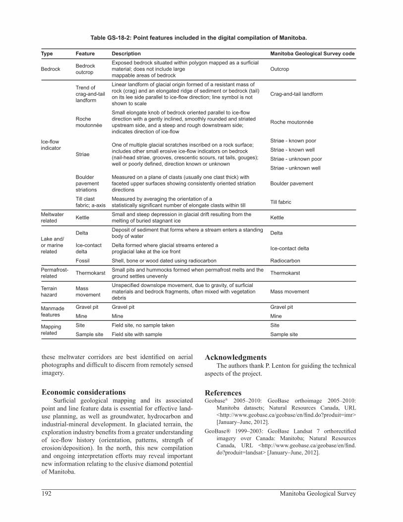
Table GS-18-2: Point features included in the digital compilation of Manitoba.
Type Feature Description Manitoba Geological Survey code
Bedrock Bedrock outcrop
Exposed bedrock situated within polygon mapped as a surficial material; does not include large mappable areas of bedrock
Outcrop
Ice-flow indicator
Trend of crag-and-tail landform
Linear landform of glacial origin formed of a resistant mass of rock (crag) and an elongated ridge of sediment or bedrock (tail) on its lee side parallel to ice-flow direction; line symbol is not shown to scale
Crag-and-tail landform
Roche moutonnée
Small elongate knob of bedrock oriented parallel to ice-flow direction with a gently inclined, smoothly rounded and striated upstream side, and a steep and rough downstream side; indicates direction of ice-flow
Roche moutonnée
Striae
One of multiple glacial scratches inscribed on a rock surface; includes other small erosive ice-flow indicators on bedrock (nail-head striae, grooves, crescentic scours, rat tails, gouges); well or poorly defined, direction known or unknown
Striae - known poor
Striae - known well
Striae - unknown poor
Striae - unknown well
Boulder pavement striations
Measured on a plane of clasts (usually one clast thick) with faceted upper surfaces showing consistently oriented striation directions
Boulder pavement
Till clast fabric; a-axis
Measured by averaging the orientation of a statistically significant number of elongate clasts within till Till fabric
Meltwater related Kettle Small and steep depression in glacial drift resulting from the
melting of buried stagnant ice Kettle
Lake and/or marine related
Delta Deposit of sediment that forms where a stream enters a standing body of water Delta
Ice-contact delta
Delta formed where glacial streams entered a proglacial lake at the ice front Ice-contact delta
Fossil Shell, bone or wood dated using radiocarbon Radiocarbon
Permafrost-related Thermokarst Small pits and hummocks formed when permafrost melts and the
ground settles unevenly Thermokarst
Terrain hazard
Mass movement
Unspecified downslope movement, due to gravity, of surficial materials and bedrock fragments, often mixed with vegetation debris
Mass movement
Manmade features
Gravel pit Gravel pit Gravel pit
Mine Mine Mine
Mapping related
Site Field site, no sample taken Site
Sample site Field site with sample Sample site
these meltwater corridors are best identified on aerial photographs and difficult to discern from remotely sensed imagery.
Economic considerationsSurficial geological mapping and its associated
point and line feature data is essential for effective land-use planning, as well as groundwater, hydrocarbon and industrial-mineral development. In glaciated terrain, the exploration industry benefits from a greater understanding of ice-flow history (orientation, patterns, strength of erosion/deposition). In the north, this new compilation and ongoing interpretation efforts may reveal important new information relating to the elusive diamond potential of Manitoba.
AcknowledgmentsThe authors thank P. Lenton for guiding the technical
aspects of the project.
ReferencesGeobase® 2005–2010: GeoBase orthoimage 2005–2010:
Manitoba datasets; Natural Resources Canada, URL <http://www.geobase.ca/geobase/en/find.do?produit=imr> [January–June, 2012].
GeoBase® 1999–2003: GeoBase Landsat 7 orthorectified imagery over Canada: Manitoba; Natural Resources Canada, URL <http://www.geobase.ca/geobase/en/find.do?produit=landsat> [January–June, 2012].
193Report of Activities 2012
Figure GS-18-2: Examples of imagery, at different scales, that were incorporated into the digital compilation for Manitoba: a) Shuttle Radar Topography Mission (SRTM) 90 m resolution hillshade, b) 1:250 000 scale preliminary surficial geology map, c) SPOT 4 10 m resolution, d) 1:60 000 scale aerial photograph.
94°50'0"W
94°50'0"W
55
°10
'0"N
0 21
Kilometers
a
94°50"W
94°50W
55°1
0'N
0 21
kilometres
94°50'0"W
94°50'0"W
55°1
0'0
"N
0 21
Kilometers
0 21
kilometres
94°50"W
94°50W
0 21
kilometres
55°1
0'N
94°50"W
94°50W
b
c d
55°1
0'N
94°50W
55°1
0'N
94°50W
Matile, G.L.D. and Keller, G.R. 2007: Surficial Geology Compilation Map Series of Manitoba (2nd ed.); Manitoba Science, Technology, Energy and Mines, Manitoba Geological Survey, Surficial Geology Compilation Map Series SG-CMS, 1 DVD, scale 1:250 000, 1:500 000 and 1: 1 000 000.
McMartin, I., Campbell, J.E., Dredge, L.A. and Robertson, L. 2010: A digital compilation of ice-flow indicators for central Manitoba and Saskatchewan: datasets, digital scalable maps and 1:500 000 scale generalized map; Geological Survey of Canada, Open File 6405, 1 DVD, doi:10.4095/261695
Trommelen, M.S. 2011a: Far North Geomapping Initiative: Quaternary geology of the Snyder–Grevstad lakes area, far northwestern Manitoba (parts of NTS 64N5); in Report of Activities 2011, Manitoba Innovation, Energy and Mines, Manitoba Geological Survey, p. 18–28.
Trommelen, M.S. 2011b: Surficial Geology, Snyder Lake, northwestern Manitoba (parts of NTS 64N5); Manitoba Innovation, Energy and Mines, Manitoba Geological Survey, Preliminary Map PMAP2011-4, scale 1:50 000.
Trommelen, M.S. and Ross, M. 2010: Subglacial landforms in northern Manitoba, Canada, based on remote sensing data; Journal of Maps, v. 2010, p. 618–638.
United States Geological Survey 2002: Shuttle Radar Topography Mission, digital topographic data; United States Geological Survey, URL <http://dds.cr.usgs.gov/srtm/>, 90 m cell, zipped hgt format [December 2011–June 2012].