QUARTERLY ACTIVITIES REPORT - dmaltd.com.au...fine textures within the iron oxides possibly...
7
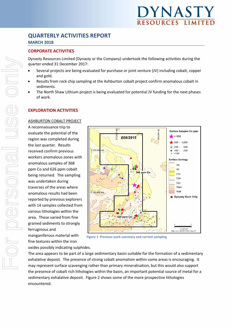
QUARTERLY ACTIVITIES REPORT MARCH 2018 CORPORATE ACTIVITIES Dynasty Resources Limited (Dynasty or the Company) undertook the following activities during the quarter ended 31 December 2017: • Several projects are being evaluated for purchase or joint venture (JV) including cobalt, copper and gold. • Results from rock chip sampling at the Ashburton cobalt project confirm anomalous cobalt in sediments. • The North Shaw Lithium project is being evaluated for potential JV funding for the next phases of work. EXPLORATION ACTIVITIES ASHBURTON COBALT PROJECT A reconnaissance trip to evaluate the potential of the region was completed during the last quarter. Results received confirm previous workers anomalous zones with anomalous samples of 368 ppm Co and 626 ppm cobalt being returned. The sampling was undertaken during traverses of the areas where anomalous results had been reported by previous explorers with 14 samples collected from various lithologies within the area. These varied from fine grained sediments to strongly ferruginous and manganiferous material with fine textures within the iron oxides possibly indicating sulphides. The area appears to be part of a large sedimentary basin suitable for the formation of a sedimentary exhalative deposit. The presence of strong cobalt anomalism within some areas is encouraging. It may represent surface scavenging rather than primary mineralisation, but this would also support the presence of cobalt rich lithologies within the basin, an important potential source of metal for a sedimentary exhalative deposit. Figure 2 shows some of the more prospective lithologies encountered. Figure 1 Previous work summary and current sampling For personal use only
Transcript of QUARTERLY ACTIVITIES REPORT - dmaltd.com.au...fine textures within the iron oxides possibly...
QUARTERLY ACTIVITIES REPORT MARCH 2018
CORPORATE ACTIVITIES
Dynasty Resources Limited (Dynasty or the Company) undertook the following activities during the quarter ended 31 December 2017: • Several projects are being evaluated for purchase or joint venture (JV) including cobalt, copper
and gold. • Results from rock chip sampling at the Ashburton cobalt project confirm anomalous cobalt in
sediments. • The North Shaw Lithium project is being evaluated for potential JV funding for the next phases
of work.
EXPLORATION ACTIVITIES
ASHBURTON COBALT PROJECT A reconnaissance trip to evaluate the potential of the region was completed during the last quarter. Results received confirm previous workers anomalous zones with anomalous samples of 368 ppm Co and 626 ppm cobalt being returned. The sampling was undertaken during traverses of the areas where anomalous results had been reported by previous explorers with 14 samples collected from various lithologies within the area. These varied from fine grained sediments to strongly ferruginous and manganiferous material with fine textures within the iron oxides possibly indicating sulphides. The area appears to be part of a large sedimentary basin suitable for the formation of a sedimentary exhalative deposit. The presence of strong cobalt anomalism within some areas is encouraging. It may represent surface scavenging rather than primary mineralisation, but this would also support the presence of cobalt rich lithologies within the basin, an important potential source of metal for a sedimentary exhalative deposit. Figure 2 shows some of the more prospective lithologies encountered.
Figure 1 Previous work summary and current sampling
For
per
sona
l use
onl
y
March 2018 Quarterly Report 2
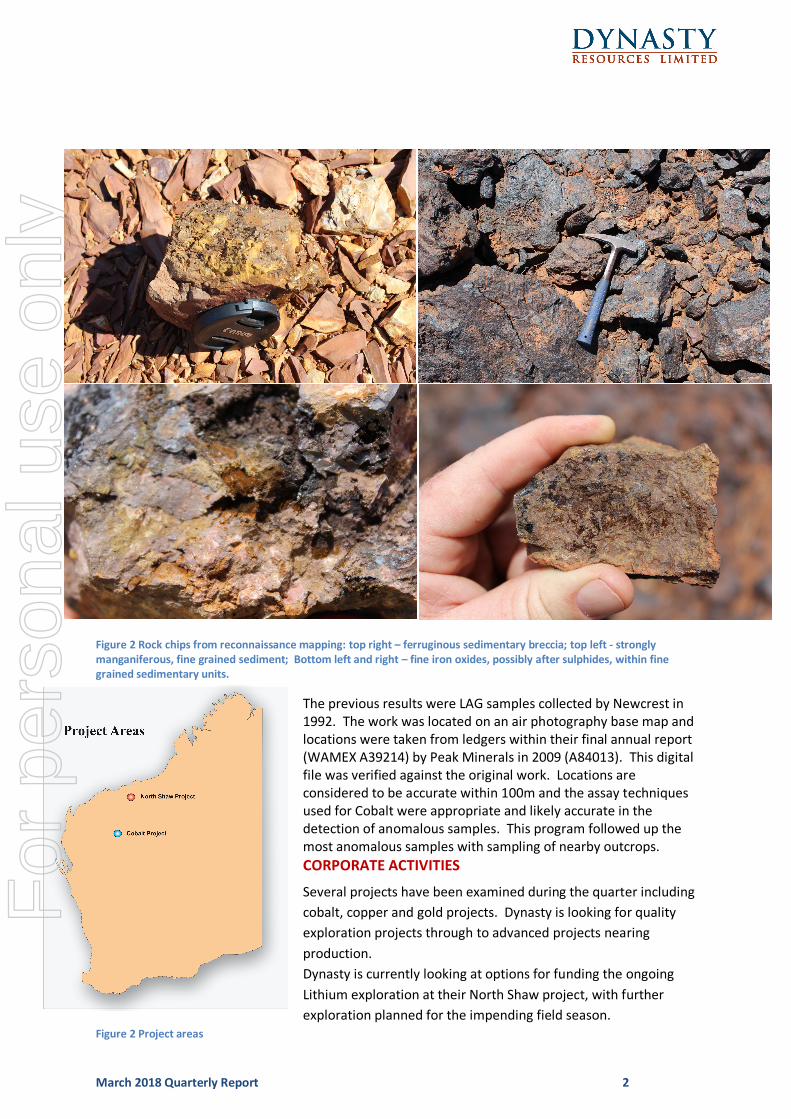
Figure 2 Rock chips from reconnaissance mapping: top right – ferruginous sedimentary breccia; top left - strongly
manganiferous, fine grained sediment; Bottom left and right – fine iron oxides, possibly after sulphides, within fine
grained sedimentary units.
The previous results were LAG samples collected by Newcrest in 1992. The work was located on an air photography base map and locations were taken from ledgers within their final annual report (WAMEX A39214) by Peak Minerals in 2009 (A84013). This digital file was verified against the original work. Locations are considered to be accurate within 100m and the assay techniques used for Cobalt were appropriate and likely accurate in the detection of anomalous samples. This program followed up the most anomalous samples with sampling of nearby outcrops. CORPORATE ACTIVITIES
Several projects have been examined during the quarter including cobalt, copper and gold projects. Dynasty is looking for quality exploration projects through to advanced projects nearing production. Dynasty is currently looking at options for funding the ongoing Lithium exploration at their North Shaw project, with further exploration planned for the impending field season.
Figure 2 Project areas
For
per
sona
l use
onl
y
March 2018 Quarterly Report 3
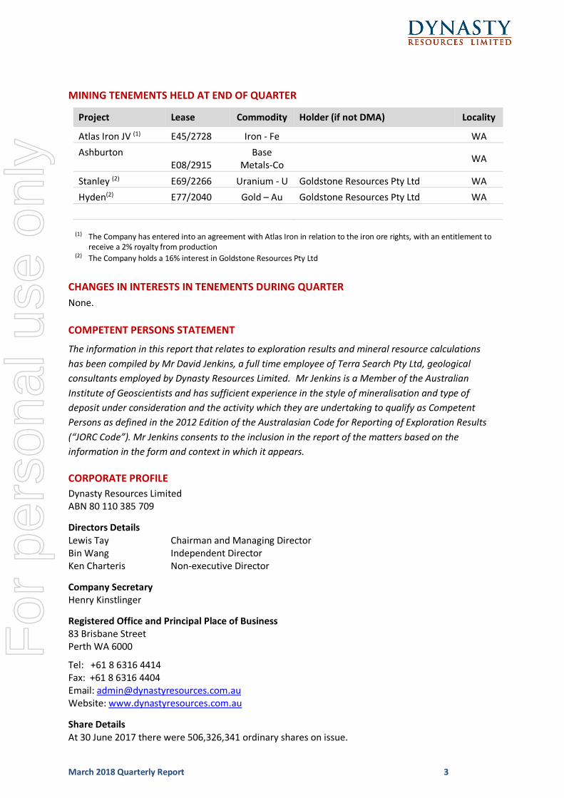
MINING TENEMENTS HELD AT END OF QUARTER
Project Lease Commodity Holder (if not DMA) Locality
Atlas Iron JV (1) E45/2728 Iron - Fe WA Ashburton
E08/2915 Base
Metals-Co WA
Stanley (2) E69/2266 Uranium - U Goldstone Resources Pty Ltd WA
Hyden(2) E77/2040 Gold – Au Goldstone Resources Pty Ltd WA
(1) The Company has entered into an agreement with Atlas Iron in relation to the iron ore rights, with an entitlement to
receive a 2% royalty from production (2) The Company holds a 16% interest in Goldstone Resources Pty Ltd
CHANGES IN INTERESTS IN TENEMENTS DURING QUARTER
None.
COMPETENT PERSONS STATEMENT
The information in this report that relates to exploration results and mineral resource calculations has been compiled by Mr David Jenkins, a full time employee of Terra Search Pty Ltd, geological consultants employed by Dynasty Resources Limited. Mr Jenkins is a Member of the Australian Institute of Geoscientists and has sufficient experience in the style of mineralisation and type of deposit under consideration and the activity which they are undertaking to qualify as Competent Persons as defined in the 2012 Edition of the Australasian Code for Reporting of Exploration Results (“JORC Code”). Mr Jenkins consents to the inclusion in the report of the matters based on the information in the form and context in which it appears.
CORPORATE PROFILE Dynasty Resources Limited ABN 80 110 385 709
Directors Details
Lewis Tay Chairman and Managing Director Bin Wang Independent Director Ken Charteris Non-executive Director
Company Secretary
Henry Kinstlinger
Registered Office and Principal Place of Business
83 Brisbane Street Perth WA 6000
Tel: +61 8 6316 4414 Fax: +61 8 6316 4404 Email: [email protected] Website: www.dynastyresources.com.au
Share Details
At 30 June 2017 there were 506,326,341 ordinary shares on issue.
For
per
sona
l use
onl
y

March 2018 Quarterly Report 4
JORC2012Table1-
Criteria JORC Code explanation Commentary Sampling techniques
• Nature and quality of sampling (eg cut channels, random chips, or specific specialised industry standard measurement tools appropriate to the minerals under investigation, such as down hole gamma sondes, or handheld XRF instruments, etc). These examples should not be taken as limiting the broad meaning of sampling.
• Include reference to measures taken to ensure sample representivity and the appropriate calibration of any measurement tools or systems used.
• Aspects of the determination of mineralisation that are Material to the Public Report.
• In cases where ‘industry standard’ work has been done this would be relatively simple (eg ‘reverse circulation drilling was used to obtain 1 m samples from which 3 kg was pulverised to produce a 30 g charge for fire assay’). In other cases more explanation may be required, such as where there is coarse gold that has inherent sampling problems. Unusual commodities or mineralisation types (eg submarine nodules) may warrant disclosure of detailed information.
• Surface rock chip samples from outcropping lithologies
• Selected samples were taken of prospective lithologies.
Drilling techniques
• Drill type (eg core, reverse circulation, open-hole hammer, rotary air blast, auger, Bangka, sonic, etc) and details (eg core diameter, triple or standard tube, depth of diamond tails, face-sampling bit or other type, whether core is oriented and if so, by what method, etc).
Not Applicable
Drill sample recovery
• Method of recording and assessing core and chip sample recoveries and results assessed.
• Measures taken to maximise sample recovery and ensure representative nature of the samples.
• Whether a relationship exists between sample recovery and grade and whether sample bias may have occurred due to preferential loss/gain of fine/coarse material.
• Not Applicable
Logging • Whether core and chip samples have been geologically and geotechnically logged to a level of detail to support appropriate Mineral Resource estimation, mining studies and metallurgical studies.
• Whether logging is qualitative or quantitative in nature. Core (or costean, channel, etc) photography.
• The total length and percentage of the relevant intersections logged.
• Lithological observation made
Sub-sampling techniques and sample preparation
• If core, whether cut or sawn and whether quarter, half or all core taken.
• If non-core, whether riffled, tube sampled, rotary split, etc and whether sampled wet or dry.
• For all sample types, the nature, quality and appropriateness of the sample preparation technique.
• Quality control procedures adopted for all sub-sampling stages to maximise representivity of samples.
• Measures taken to ensure that the sampling is representative of the in situ material collected, including for instance results for field duplicate/second-half sampling.
• Whether sample sizes are appropriate to the grain size of
• Not Applicable •
For
per
sona
l use
onl
y
March 2018 Quarterly Report 5
Criteria JORC Code explanation Commentary the material being sampled.
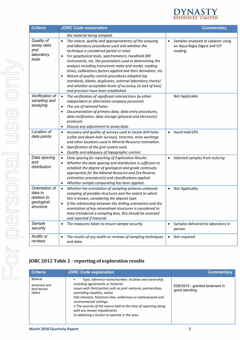
Quality of assay data and laboratory tests
• The nature, quality and appropriateness of the assaying and laboratory procedures used and whether the technique is considered partial or total.
• For geophysical tools, spectrometers, handheld XRF instruments, etc, the parameters used in determining the analysis including instrument make and model, reading times, calibrations factors applied and their derivation, etc.
• Nature of quality control procedures adopted (eg standards, blanks, duplicates, external laboratory checks) and whether acceptable levels of accuracy (ie lack of bias) and precision have been established.
• Samples analysed at Labwest using an Aqua Regia Digest and ICP reading.
Verification of sampling and assaying
• The verification of significant intersections by either independent or alternative company personnel.
• The use of twinned holes. • Documentation of primary data, data entry procedures,
data verification, data storage (physical and electronic) protocols.
• Discuss any adjustment to assay data.
Not Applicable
Location of data points
• Accuracy and quality of surveys used to locate drill holes (collar and down-hole surveys), trenches, mine workings and other locations used in Mineral Resource estimation.
• Specification of the grid system used. • Quality and adequacy of topographic control.
• Hand held GPS
Data spacing and distribution
• Data spacing for reporting of Exploration Results. • Whether the data spacing and distribution is sufficient to
establish the degree of geological and grade continuity appropriate for the Mineral Resource and Ore Reserve estimation procedure(s) and classifications applied.
• Whether sample compositing has been applied.
• Selected samples from outcrop
Orientation of data in relation to geological structure
• Whether the orientation of sampling achieves unbiased sampling of possible structures and the extent to which this is known, considering the deposit type.
• If the relationship between the drilling orientation and the orientation of key mineralised structures is considered to have introduced a sampling bias, this should be assessed and reported if material.
• Not Applicable
Sample security
• The measures taken to ensure sample security. • Samples delivered to laboratory in person
Audits or reviews
• The results of any audits or reviews of sampling techniques and data.
• Not required
JORC2012Table2-reportingofexplorationresults
Criteria JORC Code explanation Commentary Mineral
tenement and land tenure status
• Type, reference name/number, location and ownership including agreements or material issues with third parties such as joint ventures, partnerships, overriding royalties, native title interests, historical sites, wilderness or national park and environmental settings. • The security of the tenure held at the time of reporting along with any known impediments to obtaining a licence to operate in the area.
E08/2915 - granted tenement in good standing.
For
per
sona
l use
onl
y
March 2018 Quarterly Report 6
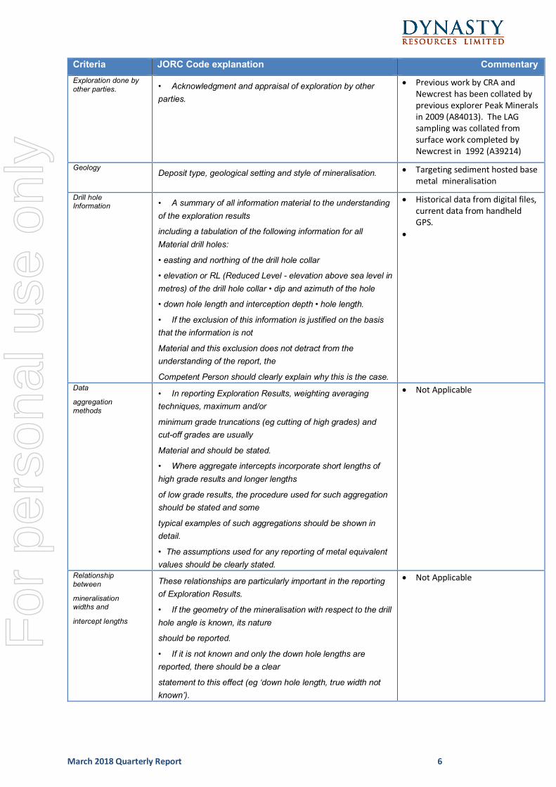
Criteria JORC Code explanation Commentary Exploration done by other parties. • Acknowledgment and appraisal of exploration by other
parties.
• Previous work by CRA and Newcrest has been collated by previous explorer Peak Minerals in 2009 (A84013). The LAG sampling was collated from surface work completed by Newcrest in 1992 (A39214)
Geology Deposit type, geological setting and style of mineralisation. • Targeting sediment hosted base
metal mineralisation
Drill hole Information
• A summary of all information material to the understanding of the exploration results
including a tabulation of the following information for all Material drill holes:
• easting and northing of the drill hole collar
• elevation or RL (Reduced Level - elevation above sea level in metres) of the drill hole collar • dip and azimuth of the hole
• down hole length and interception depth • hole length.
• If the exclusion of this information is justified on the basis that the information is not
Material and this exclusion does not detract from the understanding of the report, the
Competent Person should clearly explain why this is the case.
• Historical data from digital files, current data from handheld GPS.
•
Data
aggregation methods
• In reporting Exploration Results, weighting averaging techniques, maximum and/or
minimum grade truncations (eg cutting of high grades) and cut-off grades are usually
Material and should be stated.
• Where aggregate intercepts incorporate short lengths of high grade results and longer lengths
of low grade results, the procedure used for such aggregation should be stated and some
typical examples of such aggregations should be shown in detail.
• The assumptions used for any reporting of metal equivalent values should be clearly stated.
• Not Applicable
Relationship between
mineralisation widths and
intercept lengths
These relationships are particularly important in the reporting of Exploration Results.
• If the geometry of the mineralisation with respect to the drill hole angle is known, its nature
should be reported.
• If it is not known and only the down hole lengths are reported, there should be a clear
statement to this effect (eg ‘down hole length, true width not known’).
• Not Applicable
For
per
sona
l use
onl
y
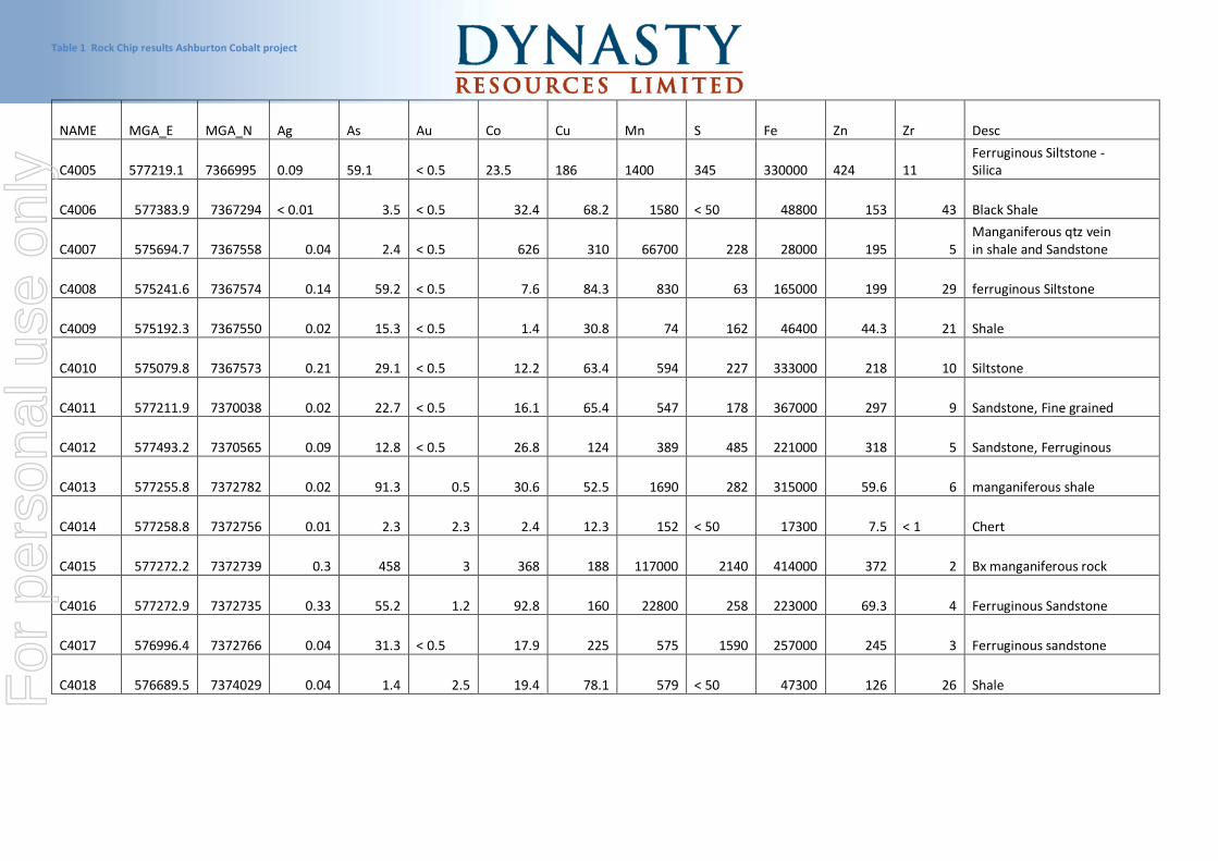
Table 1 Rock Chip results Ashburton Cobalt project
NAME MGA_E MGA_N Ag As Au Co Cu Mn S Fe Zn Zr Desc
C4005 577219.1 7366995 0.09 59.1 < 0.5 23.5 186 1400 345 330000 424 11 Ferruginous Siltstone - Silica
C4006 577383.9 7367294 < 0.01 3.5 < 0.5 32.4 68.2 1580 < 50 48800 153 43 Black Shale
C4007 575694.7 7367558 0.04 2.4 < 0.5 626 310 66700 228 28000 195 5 Manganiferous qtz vein in shale and Sandstone
C4008 575241.6 7367574 0.14 59.2 < 0.5 7.6 84.3 830 63 165000 199 29 ferruginous Siltstone
C4009 575192.3 7367550 0.02 15.3 < 0.5 1.4 30.8 74 162 46400 44.3 21 Shale
C4010 575079.8 7367573 0.21 29.1 < 0.5 12.2 63.4 594 227 333000 218 10 Siltstone
C4011 577211.9 7370038 0.02 22.7 < 0.5 16.1 65.4 547 178 367000 297 9 Sandstone, Fine grained
C4012 577493.2 7370565 0.09 12.8 < 0.5 26.8 124 389 485 221000 318 5 Sandstone, Ferruginous
C4013 577255.8 7372782 0.02 91.3 0.5 30.6 52.5 1690 282 315000 59.6 6 manganiferous shale
C4014 577258.8 7372756 0.01 2.3 2.3 2.4 12.3 152 < 50 17300 7.5 < 1 Chert
C4015 577272.2 7372739 0.3 458 3 368 188 117000 2140 414000 372 2 Bx manganiferous rock
C4016 577272.9 7372735 0.33 55.2 1.2 92.8 160 22800 258 223000 69.3 4 Ferruginous Sandstone
C4017 576996.4 7372766 0.04 31.3 < 0.5 17.9 225 575 1590 257000 245 3 Ferruginous sandstone
C4018 576689.5 7374029 0.04 1.4 2.5 19.4 78.1 579 < 50 47300 126 26 Shale
For
per
sona
l use
onl
y


![2009 Proceedings_Processing of Refractory Sulphides at Mantos de or[877175]](https://static.fdocuments.in/doc/165x107/552e3a7d4a7959485c8b48de/2009-proceedingsprocessing-of-refractory-sulphides-at-mantos-de-or877175.jpg)